BE IT ORDAINED by the Board of Supervisors of Chesterfield County:
|
|
|
- Roger Leonard Reeves
- 5 years ago
- Views:
Transcription
1
2
3 Attachment A AN ORDINANCE TO AMEND THE CODE OF THE COUNTY OF CHESTERFIELD, 1997, AS AMENDED, BY AMENDING AND REENACTING SECTIONS , , , , , , , , , & OF THE ZONING ORDINANCE RELATING TO NORTHERN JEFFERSON DAVIS HIGHWAY DESIGN DISTRICT AND AUTOMOBILE AND MOTOR VEHICLE RELATED USES IN SHOPPING CENTERS. BE IT ORDAINED by the Board of Supervisors of Chesterfield County: (1) That Sections , , , , , , , , , & of the Code of the County of Chesterfield, 1997, as amended, are amended and re-enacted, to read as follows Use Table A. USES ENUMERATED. P = Permitted by Right R and RS = Permitted with Restrictions A=Accessory C = Conditional Use S = Special Exception M = Manufactured Home Permit Zoning Districts R-7 R-C R-TH R-MF MH-1 MH-2 MH-3 A O-1 O-2 C-1 C-2 C-3 C-4 C-5 I-1 I-2 I-3 thru 88 OOO Automobile rental C R R R RP C C C Automobile repair, excluding body, major engine or transmission C R R RP C C OOO Automobile sales, excluding consignment lot C R R RP C C OOO Motor vehicle sales RP C C OOO Sec Restricted Uses Listed as R or RS. Automobile rental 1. C-2 District: a. Use is not located in Bon Air Special Design District; or a.b. Use is not located within a shopping center; and b.c. Automobile repair or sales does not occur. 1
4 Attachment A 2. C-3, C-4 Districts: a. Use is not located in Bon Air Special Design District, or within a shopping center unless it was within the center prior to May 26, 2004; b. Elevated display of automobiles does not occur; c. Use is set back 100 feet from adjacent R, R-TH, R-MF or O property, or adjacent A property shown on the comprehensive plan for R, R-TH, R-MF or O uses. The setback is landscaped at a density of 2.5 times Perimeter Landscaping C; d. Garage-type doors are either oriented away from, or screened from view of, adjacent R, R-TH, R-MF or O property, adjacent external roads, or adjacent A property shown on the comprehensive plan for residential or office uses; e. Repair services occur only as accessory to the use, and repair does not include body repair; f. Except for minimal repairs necessary to allow a vehicle to be moved into the service area, repair activities and storage of new or replaced repair materials either occurs inside a building, or the area is screened from view of adjacent R, R-TH, R-MF or O property, adjacent external roads, or adjacent A property shown on the comprehensive plan for residential or office uses; and g. Storage yards for vehicles awaiting body repair, painting, auction or wholesale sales are screened from view of adjacent property on which such yards are not permitted or do not exist, adjacent external roads, or adjacent A property shown on the comprehensive plan for residential or office uses. 3. C-5 Districts: a. Use is not located in Bon Air Special Design District; b. Use is not located within a shopping center; Automobile repair excluding body, major engine or transmission 1. C-3, C-4 Districts: a. Use is not located in Bon Air or Chester Special Design Districts; and b. The following requirements are met unless the use was in operation prior to May 26, 2004: Use is not within a shopping center; Use is set back 100 feet from adjacent R, RTH, R-MF or O property, or A property shown on the comprehensive plan for R, R-TH, R-MF or O uses. The setback is landscaped at a density of 2.5 times Perimeter Landscaping C; Except for minimal repairs necessary to allow a vehicle to be moved into the service area, repair activities and storage of new or replaced repair materials shall either occur inside a building, or the area is screened from view of adjacent R, R-TH, R-MF or O properties, adjacent external roads, or adjacent A property shown on the comprehensive plan for residential or office uses; and Storage yards for vehicles awaiting body repair or painting are screened from view of adjacent property on which such yards are not permitted or do not exist, adjacent external roads, or adjacent A property shown on the comprehensive plan for residential or office uses. 2
5 Attachment A 2. a. Use is not located in Bon Air or Chester Special Design Districts; and b. Use is not located within a shopping center. Automobile repair including body, major engine or transmission a. Use is not located in Midlothian Area East; and. b. Use is not located in a shopping center. Automobile sales excluding consignment lots 1. C-3, C-4 Districts: a. Use is not located in Special Design Districts; b. Use is not within a shopping center unless it was within the center prior to May 26, 2004; c. Elevated display of motor vehicles does not occur; d. Use is set back 100 feet from adjacent R, R-TH, R-MF or O property, or A property shown on the comprehensive plan for R, R-TH, R-MF or O uses. The setback is landscaped at a density of 2.5 times Perimeter Landscaping C; e. Garage-type doors are either oriented away from, or screened from view of, adjacent R, R-TH, R-MF or O property, adjacent external roads, or adjacent A property shown on the comprehensive plan for residential or office uses; f. Repair services occur only as accessory to the use and repair does not include body repair; g. Except for minimal repairs necessary to allow a vehicle to be moved into the service area, either repair activities and storage of new or replaced repair materials occurs inside a building, or the repair area is screened from view of adjacent R, R-TH, R-MF or O properties, adjacent external roads, or adjacent A property shown on the comprehensive plan for residential or office use; and h. Storage yards for vehicles awaiting body repair, painting, auction or wholesale sales are screened from view of adjacent property on which such yards are not permitted or do not exist, adjacent external roads, or adjacent A property shown on the comprehensive plan for residential or office uses. 2. Use is not located within a shopping center. Boat sales, service, repair and rental a. Use is not located in Midlothian Area East.; and b. Use is not located within a shopping center. Farm equipment, implement and machinery sales, repair and rental 3
6 Attachment A a. Use is not located in Midlothian Area East;. and b. Use is not located within a shopping center. Manufactured home sales, service, repair and rental a. Use is not located in Midlothian Area East; and a.b. Use is not located within a shopping center. Modular home sales, service, repair and rental a. Use is not located in Midlothian Area East;. and a.b. Use is not located within a shopping center. Motor vehicle rental a. Use is not located in Midlothian Area East; and. b. Use is not located within a shopping center. Motor vehicle repair a. Use is not located in Midlothian Area East;. and b. Use is not located within a shopping center. Recreational equipment sales, service and repair excluding boats a. Use is not located in Midlothian Area East; and. b. Sales, service or repair of recreational vehicles does not occur within a shopping center. Rental of heavy equipment a. Use is not located in Midlothian Area East;. and 4
7 Attachment A b. Use is not located within a shopping center. Travel trailer sales, service, repair and rental Truck rental a. Use is not located in Midlothian Area East;. and b. Use is not located within a shopping center. a. Use is not located in Midlothian Area East;. and b. Use is not located within a shopping center. Utility trailer rental a. Use is not located in Midlothian Area East;. and b. Use is not located within a shopping center. Utility trailer sales, service and repair a. Use is not located in Midlothian Area East;. and b. Use is not located within a shopping center. Vendor, outdoor, fruit, vegetable and prepared food 1. C-2 District: a. Sales are restricted to retail of fruits, vegetables and prepared food; b. Use is located on property occupied by a permanent use; c. Use is located where improved permanent parking facilities are available for use; d. Required minimum and most convenient parking spaces for the permanent use are not used; e. Vendor areas are either: set back 100 feet from R, R-TH or R-MF property, or A property designated for residential use on the comprehensive plan; or sales areas are separated from such property by a permanent building; 5
8 Attachment A f. Vendor areas conform to the setback requirements of the district except in Ettrick Special Design District or the Northern Jefferson Davis Highway Design District where use may be located within permitted hardscaped pedestrian areas; g. 1 stand not to exceed 200 square feet is allowed; h. 1 properly licensed, inspected and operative truck or other vehicle associated with the vendor use is parked; i. Use is not operated more frequently than 3 consecutive days nor more than 3 days in any 7 day period beginning on Monday and ending on Sunday; j. Hours of operation is limited to those of the permanent use; k. Stand, vehicle, signs, trash, debris or other material associated with, or resulting from, the use is removed no later than 24 hours following the end of each sales period. 2. C-3, C-4, C-5 Districts: a. Sales are restricted to retail of fruits, vegetables and prepared food; b. Use is located on property occupied by a permanent use; c. Use is located where improved permanent parking facilities are available for use; d. Required minimum and most convenient parking spaces for the permanent use are not used; e. Vendor areas are either: set back 1,300 feet from R, R-TH or R-MF property, or A property designated for residential use on the comprehensive plan; or sales areas are separated from such property by a permanent building; f. Vendor areas conform to the setback requirements of the district except in the Northern Jefferson Davis Highway Design District where use may be located within permitted hardscaped pedestrian areas; and g. Stands, vehicles, signs, trash, debris or other material associated with, or resulting from, the use is removed no later than 24 hours following the cessation of the use. Sec Required Parking Spaces per Use. Table A. Required Number of Parking Spaces by Use Number of Spaces Required Specific Use General Use Category or All Areas Excluding Special Design Districts Size of Use Special Design Districts [2] [3] [4] [1] [2] [3] [4] OOO OOO OOO OOO 6
9 Attachment A Notes for Table A. [1] In the Northern Jefferson Davis Highway Design District Corridor, parking requirements for nonresidential uses shall be based upon the lesser of that outlined in the Table or 4.4 per 1 s/f of gfa. [2] In the Northern Jefferson Davis Highway Design DistrictCorridor, Employment Center, Special Design Districts and C-1 Districts, the required number of parking spaces may be reduced by 10% if the development contains a sidewalk or other pedestrian system which connects, or will connect, to existing or future sidewalks or pedestrian systems. [3] In the Northern Jefferson Davis Highway Corridor Design District and Special Design Districts, for nonresidential uses parking spaces in a road may be counted toward the required number of parking spaces when more than 1/2 of the space adjoins the use. [4] Within a non-residential development adjacent to a bikeway required by Sec , the number of parking spaces may be reduced by 1 for each 6 bicycle storage spaces, with a maximum reduction of 3 and provided a minimum of 5 parking spaces shall be provided. [5] For residential uses, parking spaces within a garage or an enclosed or covered space may be counted toward parking requirements. [6] In an MH-1 District, one of the required parking spaces may be located in a common parking area within the park. [7] If a drop-off or pick-up area is provided directly from vehicles to the building, stacking space shall be provided. If such an area is not provided, 5 additional parking spaces shall be installed. If care is provided for school age children, a sidewalk shall be installed from the building to the school bus stop for the facility. [8] In the Ettrick Special Design District, parking requirements for the use shall be based upon 2.2 parking spaces per 1, s/f of gfa. [9] The required number of spaces shall be based upon the square footage of the outside dining that exceeds 20 percent of the gfa of the associated principal use. Sec Tree Preservation. A. Setbacks along Roads and Buffers. 1. Preservation. Existing trees and shrubs within required setbacks along roads and buffers shall be retained to provide continuity, improve buffering, and minimize new landscaping that requires watering.; except that, in the Northern Jefferson Davis Highway Design District, tree preservation shall not be required along a road where parking is located within 10 feet of the road. At time of plan review, removal of existing healthy vegetation may be approved to accommodate vehicular access or utilities that run generally perpendicular through the setback or buffer, or as necessary to accommodate healthy vegetative growth. 7
10 Attachment A Sec Landscaping Standards for Surface Parking Areas. B. Required Landscaped Area. With the exception of parking areas in the Northern Jefferson Davis Highway Design District, ppaved parking areas shall have 30 square feet of interior landscaping for each space. Required landscape areas for individual type trees shall be as per Table B. TABLE B. Landscape Area Requirements for Parking Minimum Size Of Landscape Area Landscape Type Area (s/f) [1] Dimension of Landscape Area at Tree Location (ft) Large Deciduous Trees [2] Small Deciduous Trees [2] Continuous Planting Islands Notes for Table B. [1] If approved through plan review, a maximum of 10 percent of the required area may be smaller. [2] In lieu of planting in isolated areas, required trees may be planted in continuous planting islands, as specified herein. Sec Specific Buffer Requirements. A. Buffers between Different Zoning Districts. 1. Exemptions. The buffers shown in Table A.1.a. shall not apply to O and C property located in the Ettrick and Bon Air Special Design Districts. 2. Buffer Widths. Buffers shall be provided between different zoning districts as outlined in Tables A.1.a. and A.1.b. 8
11 Attachment A Table A.1.b. Required Buffers Between Different Zoning Districts Within Northern Jefferson Davis Highway Design District Adjacent Property Zoning and Buffer Width(feet) [1][2] Vacant A Designated on Subject Property Zoning Comprehensive Plan for Residential Use or R-7 thru R-88, R-C R-TH MH R-MF R-TH 25 R-MF O O C C C C C I I I Note for Table A.1.b. [1] If the Northern Jefferson Davis Design District requirements allow building or parking areas to be constructed without being set back from the property line, a buffer shall not be required. Except for C-5 and I Districts, the buffer width may be reduced as follows: a. 10 feet in width with a wall provided along the property line. The wall must be a minimum of 6 feet in height, composed either of brick, stone or other durable masonry material approved by the planning department. b. 5 feet in width with a wall provided along the property line as outlined in footnote 1.a. where the only use within 45 feet of the property line is automobile parking. c. No buffer for a building if the building wall adjacent to the property line has no openings, and no openings occur within 10 feet of the property line. Remainder of buffer to be 25 feet or as provided in a and b above. [2] For a C-5 district, the buffer may be reduced to 15 feet with a 6 foot wall, as outlined in a. above, along the property line, with upward growing evergreen trees planted 10 feet on center for the length of the wall. 9
12 Attachment A Sec Zoning Districts and Areas of Applicability. The provisions of this division apply to O, C and I zoned property in Emerging Growth Design District as shown on the zoning maps. The Emerging Growth Design District is generally the area as shaded in Figure FIX MAP Figure: Sec Zoning Districts and Areas of Applicability. A. The provisions of this division apply to O, C and I zoned property in Post Development Design District. B. The Post Development Design District shall be comprised of the following areas as generally shown on the zoning maps and described as follows: 10
13 Attachment A 2. Jefferson Davis Highway: a. Eastern area, south of the county line, west of the boundaries of the Northern Jefferson Davis Highway Design District, to the James River, east of the center line of Interstate 95, north of Proctors Creek. The area also includes, and an area located south of Proctors creek, west of the Emerging Growth District, east of the center line of Interstate 95, to the center line of Coxendale Road. The eastern Jefferson Davis Highway Post Development Design District is generally the area as shaded in Figure B.2.a.; Figure: B.2.a. FIX MAP b. Central area, from Route 288 to the center line of Old Bermuda Hundred Road. This district extends east from the center line of Jefferson Davis Highway to Interstate 95. The and width of this district is west from the center line of Jefferson Davis Highway a minimum of 800 feet east and west of the centerline of Jefferson Davis Highway, but if any portion of a project extends further than 800 feet, the requirements apply to the entire project. The central Jefferson Davis Highway Post Development Design District is generally the area as shaded in Figure B.2.b.; FIX MAP Figure: B.2.b. 11
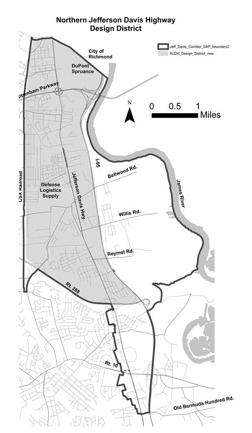
14 Attachment A DIVISION 19. NORTHERN JEFFERSON DAVIS HIGHWAY DESIGN DISTRICT Purpose and Intent of Northern Jefferson Highway Design District. Sec Purpose and Intent of Northern Jefferson Highway Design District. The purpose and intent of the Northern Jefferson Davis Highway Design District is to recognize the opportunities to shape patterns of development in accordance with the goals, guidelines, and recommendations of the Northern Jefferson Davis Special Area Plan. The requirements are designed to enhance the quality, appearance and functions of development along Jefferson Davis Highway and connecting roads and to foster the creation of a higher density and pedestrianfriendly environment.area as unique and enhance development patterns. Sec Zoning Districts and Area of Applicability. The provisions of this division apply to O, C and I zoned property in the Northern Jefferson Davis Highway Design District as shown on the zoning maps. The Northern Jefferson Highway Design District is generally both the areas as shaded in Figure FIX 12
15 Attachment A Figure: Draft Map non shaded area will become post development 13
16 Attachment A FIX MAP 14
17 Attachment A OOO Sec Required Conditions Northern Jefferson Davis Highway Design District. A. Building and Parking. Buildings and parking in Northern Jefferson Davis Highway Design District shall meet the requirements outlined in Tables A.1 and A.2: Table A.1. O and C Districts Northern Jefferson Davis Highway Design District Building and Parking Required Conditions A. Building Setbacks (feet) [1] /Required Perimeter Landscaping 1. Road type 2. Interior side yard 3. Rear yard a. Limited access 40/C b. Collector or mmajor arterial 15/J25/H [2] c. Other roads 8/J25/H [2] a. Adjacent to A, R, R-TH, R-MF or MH 25/B20 [3] b. Adjacent to O, C or I 0 [4] a. Adjacent to A, R, R-TH, R-MF or MH 25/B 30 [3] b. Adjacent to O, C, or I 0 [4] B. Parking Setbacks(feet) [1] /Required Perimeter Landscaping 1. Road type 2. Interior side yard 3. Rear yard a. Limited access 40/C b. Major arterial 15/J10/H or 5/L or c. Other roads 0/M [54][6][7] 15/J10/H or 5/L or 0/M [54][6][7] a. Adjacent to A, R, R-TH, R-MF or MH 10 [35][76] b. Adjacent to O, C or I 0 [4] a. Adjacent to A, R, R-TH, R-MF or MH 25 [3][6][7] b. Adjacent to O, C or I 0 [4] C. Building Heights (maximum) [8] Lesser of 3 stories or 45 feet [9][10] 15
18 Attachment A Notes for Table A.1. [1] Setbacks may be impacted by Buffer, Setbacks Generally, Permitted Yard Encroachments for Principal Buildings, Floodplain or Chesapeake Bay regulations. [2] Landscaping shall not be required if parking is located less than 10 feet from the road. [2] Setback must be sufficient to allow for required improvements to include sidewalks, bikeways, landscaping, street trees and streetlights.this setback may be reduced to 0 feet adjacent to property designated for nonresidential uses on the comprehensive plan if the wall of the building along such property line has no openings other than those required by the fire marshal. [3] Setback may be reduced to correlate with that provided for buffers under Table A.1.b. [4] Except where adjacent to I districts, for lots having a use first permitted in the C-5 district the setback shall either be 25 feet with perimeter landscaping J or 15 feet with a 6 foot masonry wall along the property line, with upward growing evergreen trees planted 10 feet on center for the length of the wall. [5] Where buildings are constructed along an external road, no more than one row of parking and associated drive shall be located between the road and the building. For internal roads, no parking shall be provided between buildings and the road. [6] Except as provided for the single row of parking in footnote 5, parking shall be set back no closer than the front façade of the building it serves and be located behind architectural and/or landscaping features. Decorative architectural and/or landscaping features shall be designed to reduce open views of parking from the road and include improvements which accommodate pedestrian travel across storefronts, between buildings, and between sites. [4][7] For parking areas accommodating recreational equipment having a length of 25 feet or more, tractor trailers, or motor vehicles, the setback for spaces shall be increased to 50 feet and any drive serving such areas shall be setback 10 feet with Perimeter Landscaping H planted within the setback. [5] For parking areas accommodating recreational equipment having a length of 25 feet or more, tractor trailers, or motor vehicles, the setback shall be increased to 30 feet. [6] For parking areas accommodating automobiles or recreational equipment less than 25 feet in length, if the adjacent property is designated for nonresidential use by the comprehensive plan and is not occupied by a dwelling, then the setback may be reduced to zero. If such adjacent property is occupied by a dwelling, the setback may be reduced to 0 feet with a 4 foot high fence along such property line. [7] For parking areas accommodating recreational equipment having a length of 25 feet or more, tractor trailers, or motor vehicles, the setback shall be increased to 40 feet. [8] Height limits are subject to Article IV, Division 2. [9] Subject to Footnote 5, the height of offices, hospitals and hotels may be increased to the lesser of 12 stories or 120 feet, but within 100 feet of undeveloped R, R-TH, R-MF, MH or A property, height shall not exceed lesser of 3 stories or 50 feet. [10] Within 200 feet of a developed residential neighborhood, the height shall not exceed the lesser of 2 stories or 30 feet unless there is an existing dwelling more than 2 stories within 100 feet of the common boundary of the neighborhood, then the height may be increased to the height of the dwelling, but not more than the maximum permitted height. 16
19 Attachment A Table A.2. I-1, I-2 and I-3 Districts Northern Jefferson Davis Highway Design District Building and Parking Required Conditions A. Building Setbacks (feet) [1] /Required Perimeter Landscaping 1. Road type 2. Interior side yard District I-1 I-2 I-3 a. Limited access 40/C 40/C 40/C b. Major arterial 25/JH [2] 60/B 60/B c. Other roads 25/JH [2] 60/B 60/B a. Adjacent to A, R, R-TH, R-MF or MH 20 [3] 30 [3] 30 [3] b. Adjacent to O, C or I 15/J0 [2][4] 30/J [2]4] 30/J [2][4] a. Adjacent to A, R, R-TH, R-MF or MH 30 [3] 30 [3] 30 [3] 3. Rear yard b. Adjacent to O, C or I 30/J [2][4] 30/J [2][4] 30/J [2][4] B. Parking Setbacks (feet) [1] /Required Perimeter Landscaping 1. Road type 2. Interior side yard 3. Rear yard a. Limited access 40/C 40/C 40/C b. Major arterial c. Other roads C. Building Heights (maximum) [78] a. Adjacent to A, R, R-TH, R-MF or MH 50/B or 25/J 10/H or 5/L or 0/M [54] 15/J10/H or 5/L or 0/M [54] 50/B or 25/J10/H or 5/L or 0/M [54] 15/J10/H or 5/L or 0/M [54] 50/B or 25/J10/H or 5/L or 0/M [54] 15/J10/H or 5/L or 0/M [54] 10 [3][5][6] 10 [3][[5][6] 10 [3][[5][6] b. Adjacent to O, C or I 15/J ] 0 [4][6] 15/J0 [4][6] 15/J0 [4][6] a. Adjacent to A, R, R-TH, R- MF or MH 25 [6][7][3][5] 25 [6][7][3] 25 [6][7][3] b. Adjacent to O, C or I 15/J0 [4][6] 15/J0 [4][6] 15/J0 [4][6] 1. I-1 District Lesser of 3 stories or 50 feet [89][910] 2. I-2 and I-3 District 150 feet [89][910] 17
20 Attachment A Notes for Table A.2. [1] Setbacks may be impacted by Buffer, Setbacks Generally, Permitted Yard Encroachments for Principal Buildings, Floodplain or Chesapeake Bay regulations. [2] The setback shall be increased by one foot for each foot the building exceeds 45 feet in height.landscaping shall not be required if parking is located less than 10 feet from the road. [3] Setbacks shall correlate with that required for buffers as provided Table A.1.b. [3][4] Perimeter landscaping is not required adjacent to I-2 or I-3 District.This setback may be reduced to 0 feet adjacent to property designated for nonresidential uses on the comprehensive plan if the wall of the building along such property line has no openings other than those required by the fire marshal. [4][5] For parking areas accommodating recreational equipment having a length of 25 feet or more, tractor trailers, or motor vehicles, the setback for spaces shall be increased to 50 feet and any drive serving such areas may be setback 10 feet with Perimeter Landscaping H B planted within the setback. [5][6] Except where adjacent to I-2 or I-3 districts, Ffor parking areas accommodating recreational equipment having a length of 25 feet or more, tractor trailers, or motor vehicles, the setback shall be increased to 30 feet with Perimeter Landscaping J. [6] For parking areas accommodating automobiles or recreational equipment less than 25 feet in length, if the adjacent property is designated for nonresidential use by the comprehensive plan and is not occupied by a dwelling, the setback may be reduced to zero. If such adjacent property is occupied by a dwelling, the setback may be reduced to 0 feet with a 4 foot high fence along such property line. [7] For parking areas accommodating recreational equipment having a length of 25 feet or more, tractor trailers, or motor vehicles, the setback shall be increased to 40 feet. [8][7] Height limits are subject to Article IV, Division 2. [9][8] Subject to Footnote 59, height of offices, hospitals and hotels may be increased to the lesser of 12 stories or 120 feet, but within 100 feet of undeveloped R, R-TH, R-MF, MH or A property, the height shall not exceed lesser of 3 stories or 50 feet. [10][9] Within 200 feet of a developed residential neighborhood, the height shall not exceed the lesser of 2 stories or 30 feet, unless there is an existing dwelling more than 2 stories within 100 feet of the common boundary of the neighborhood, then the height may be increased to height of the dwelling, but not more than the maximum permitted height. 18
21 Attachment A B. Drive-in or Drive Through Facilities, Gasoline Pumps and Associated Drives. Drive-in or drive through facilities and gasoline pumps, shall not be located between a building and the road. Gasoline pumps and associated drives shall meet the setback requirements for parking of automobiles or recreational equipment less than 25 feet in length outlined in Tables A.1. and A.2. C. Other Required Conditions. 1. Architecture Generally. For the purposes of architectural standards, the Northern Jefferson Davis Highway Corridor District is comprised of 2 different geographies shown on the zoning maps as Area A and Area B and as generally shown in Figure In addition to the requirements of Sec , buildings shall meet the following architectural requirements: 1. Area A. Building facades visible from a road shall not be constructed of unadorned concrete block, unfinished corrugated metal or unfinished sheet metal. 2. Area B. Facades shall not be constructed of unpainted concrete block, unfinished corrugated metal or unfinished sheet metal; Use of different materials on different facades shall be permitted, but inferior materials shall not be used on sides which face adjoining property; and Facades visible to R, R-TH, R-MF, MH, A or O property, or a road shall not have architectural materials inferior in appearance or detail to any other facade of the same building or be constructed of unadorned concrete block. a. Facades visible from a road or from property that is zoned, or designated on the comprehensive plan for residential use shall not be constructed of unadorned concrete block, corrugated metal or sheet metal; and b. Use of different materials on different facades shall be permitted, but architectural materials inferior in quality, appearance or detail to any other facade on the same building shall not be used. 2. Building Design. Buildings along a road shall incorporate features that contribute to a streetfocused, pedestrian-scale development style to include, but not be limited to, the following: a. Any building along a public or private road shall architecturally front, and have main entrances that face, such road. For corner lots this shall apply to only one such road. b. The first floor of any building shall incorporate storefront windows and pedestrian entrances facing the road. Pedestrian entrances shall either connect directly to the sidewalk along the road or to a sidewalk that connects to the sidewalk along the road; and c. Where building lengths exceed 250 feet, buildings shall provide breezeways or similar designs to accommodate pedestrian access to parking located to rear of building. The 19
22 Attachment A director of planning may grant relief to this provision where it is determined that the intent to provide frequent and reasonable pedestrian access through or across sites is provided through other design means. 3. Sidewalks and Pedestrian Amenities Generally. Sidewalk and pedestrian ways shall be provided along roads, from parking areas to uses and as pedestrian connections from projects to adjacent development and sidewalks along roads. Exact location, treatment, design and use of sidewalks and pedestrian amenities shall be determined at time of plan review. Prior to plan approval, easements, acceptable to the Planning Department shall be recorded across such improvements to allow public use. 4. Uses Permitted in Hardscaped Pedestrian Areas. Hardscaped pedestrian areas may be located within required setbacks between buildings and roads. Such areas shall not encroach onto required sidewalks or bikeways. Hardscaped pedestrian areas shall be designed to facilitate, and include amenities to support, outdoor gatherings and activity such as dining, temporary vendors, civic or community events or seating areas. The areas may also include, but are not limited to, pedestrian amenities such as foundation plantings, street furnishings, benches, bike racks and trash receptacles 5. Road network arrangement. Roads and private pavement serving the development shall be arranged so as to accommodate a pedestrian friendly street focused environment and meet the following: a. Roads and private pavement shall be arranged in an interconnected grid pattern of walkable blocks; b. Blocks shall have a maximum length of 400 feet, or provide pedestrian short cuts at midblock locations to facilitate foot traffic between parallel roads; c. Arrangement shall accommodate amenities to include sidewalks, bikeways, street trees, pedestrian street lighting, pedestrian crosswalks, and on-street parking; and d. These improvements shall be developed in conjunction with projects they are intended to serve. 6. Road and Private Pavement Design a. Roads, unless otherwise specified by VDOT, and private pavement shall have concrete curb and gutter. Roads that accommodate general traffic circulation, as determined by the director of transportation, shall be designed, and constructed to, VDOT standards and taken into the state system; and b. Roads and private pavement with on-street parallel parking shall narrow at intersections to the minimum width necessary to accommodate the travel lanes of the associated road or private pavement and the narrowed portion shall include a tangent length sufficient to accommodate the width of a crosswalk perpendicular to the curb line. 7. Bikeways. In addition to the bikeways required by Sec , bikeways shall be provided throughout projects to connect uses, open spaces, and common areas within the project. If approved by VDOT, such facilities should be located within right-of-way, otherwise the 20
23 Attachment A facilities shall be located in a public easement which establishes maintenance provisions by underlying owner, owner s association or other parties as approved at time of plan review. If the development is located adjacent to a bikeway required by Sec , bikeway(s) shall be provided to connect to those shown on the Plan as well as to adjacent property, nearby public facilities, and other nearby projects, as determined at the time of plan review. 8. Street Trees. Except as provided herein street trees shall be provided in accordance with Sec Within sidewalks and other hardscaped areas tree well shall be grated. Unless otherwise approved at the time of site plan review, the same species shall be used along a road and within a project and maintenance of such trees shall be provided by adjacent owner. If approved at time of plan review, large deciduous trees as required to meet perimeter landscaping requirement along a road may be located and arranged so as to serve as street trees. 9. Exterior Lighting. In addition to the requirements of Section , the following standards shall be met: a. Streetlights. Within required setbacks along roads, pedestrian scale streetlights shall be installed as follows: Streetlights shall be designed to enhance the pedestrian character of the design district and be compatible with development standards of the district. The design of fixtures, poles and lamp shall be consistent along a road; Streetlights shall be spaced generally 60 feet on center and be located a maximum of 5 feet from right-of-way unless otherwise approved through plan review; and Fixture mounting heights shall be limited to 12 to 15 feet above the finished grade. b. Other Exterior Lighting. With the exception of pedestrian scale streetlights, exterior lighting shall comply with the following: Exterior lighting shall be designed to enhance the character of the design district and be compatible with development standards of the district; Freestanding lights shall not exceed a height of 20 feet above finished grade; and Building mounted lights shall be no higher than the roofline or parapet wall. 10. Shared Cross Access. Direct and convenient onsite vehicular circulation and reciprocal access between properties shall be provided. The intent is to require shared access drives located to the front or rear of buildings fronting Jefferson Davis Highway. 11. Deck Parking. Deck parking structures shall either have commercial or office uses located along the ground floor or be located behind another building located on the lot. 21
24
25 Attachment B AN ORDINANCE TO AMEND THE CODE OF THE COUNTY OF CHESTERFIELD, 1997, AS AMENDED, BY AMENDING AND REENACTING SECTIONS , , , , , , , , , & OF THE ZONING ORDINANCE RELATING TO NORTHERN JEFFERSON DAVIS HIGHWAY DESIGN DISTRICT AND AUTOMOBILE AND MOTOR VEHICLE RELATED USES IN SHOPPING CENTERS. BE IT ORDAINED by the Board of Supervisors of Chesterfield County: (1) That Sections , , , , , , , , , & of the Code of the County of Chesterfield, 1997, as amended, are amended and re-enacted, to read as follows Use Table A. USES ENUMERATED. P = Permitted by Right R and RS = Permitted with Restrictions A=Accessory C = Conditional Use S = Special Exception M = Manufactured Home Permit Zoning Districts R-7 R-C R-TH R-MF MH-1 MH-2 MH-3 A O-1 O-2 C-1 C-2 C-3 C-4 C-5 I-1 I-2 I-3 thru 88 OOO Automobile rental C R R R RP C C C Automobile repair, excluding body, major engine or transmission C R R RP C C OOO Automobile sales, excluding consignment lot C R R RP C C OOO Motor vehicle sales RP C C OOO Sec Restricted Uses Listed as R or RS. Automobile rental 1. C-2 District: a. Use is not located in Bon Air Special Design District; b. Use is not located within a shopping center; and c. Automobile repair or sales does not occur. 1
26 Attachment B 2. C-3, C-4 Districts: a. Use is not located in Bon Air Special Design District, or within a shopping center unless it was within the center prior to May 26, 2004; b. Elevated display of automobiles does not occur; c. Use is set back 100 feet from adjacent R, R-TH, R-MF or O property, or adjacent A property shown on the comprehensive plan for R, R-TH, R-MF or O uses. The setback is landscaped at a density of 2.5 times Perimeter Landscaping C; d. Garage-type doors are either oriented away from, or screened from view of, adjacent R, R-TH, R-MF or O property, adjacent external roads, or adjacent A property shown on the comprehensive plan for residential or office uses; e. Repair services occur only as accessory to the use, and repair does not include body repair; f. Except for minimal repairs necessary to allow a vehicle to be moved into the service area, repair activities and storage of new or replaced repair materials either occurs inside a building, or the area is screened from view of adjacent R, R-TH, R-MF or O property, adjacent external roads, or adjacent A property shown on the comprehensive plan for residential or office uses; and g. Storage yards for vehicles awaiting body repair, painting, auction or wholesale sales are screened from view of adjacent property on which such yards are not permitted or do not exist, adjacent external roads, or adjacent A property shown on the comprehensive plan for residential or office uses. 3. C-5 Districts: a. Use is not located in Bon Air Special Design District; b. Use is not located within a shopping center; Automobile repair excluding body, major engine or transmission 1. C-3, C-4 Districts: a. Use is not located in Bon Air or Chester Special Design Districts; and b. The following requirements are met unless the use was in operation prior to May 26, 2004: Use is not within a shopping center; Use is set back 100 feet from adjacent R, RTH, R-MF or O property, or A property shown on the comprehensive plan for R, R-TH, R-MF or O uses. The setback is landscaped at a density of 2.5 times Perimeter Landscaping C; Except for minimal repairs necessary to allow a vehicle to be moved into the service area, repair activities and storage of new or replaced repair materials shall either occur inside a building, or the area is screened from view of adjacent R, R-TH, R-MF or O properties, adjacent external roads, or adjacent A property shown on the comprehensive plan for residential or office uses; and Storage yards for vehicles awaiting body repair or painting are screened from view of adjacent property on which such yards are not permitted or do not exist, adjacent external roads, or adjacent A property shown on the comprehensive plan for residential or office uses. 2
27 Attachment B a. 2. Use is not located in Bon Air or Chester Special Design Districts; and b. Use is not located within a shopping center. Automobile repair including body, major engine or transmission a. Use is not located in Midlothian Area East; and b. Use is not located in a shopping center. Automobile sales excluding consignment lots 1. C-3, C-4 Districts: a. Use is not located in Special Design Districts; b. Use is not within a shopping center unless it was within the center prior to May 26, 2004; c. Elevated display of motor vehicles does not occur; d. Use is set back 100 feet from adjacent R, R-TH, R-MF or O property, or A property shown on the comprehensive plan for R, R-TH, R-MF or O uses. The setback is landscaped at a density of 2.5 times Perimeter Landscaping C; e. Garage-type doors are either oriented away from, or screened from view of, adjacent R, R-TH, R-MF or O property, adjacent external roads, or adjacent A property shown on the comprehensive plan for residential or office uses; f. Repair services occur only as accessory to the use and repair does not include body repair; g. Except for minimal repairs necessary to allow a vehicle to be moved into the service area, either repair activities and storage of new or replaced repair materials occurs inside a building, or the repair area is screened from view of adjacent R, R-TH, R-MF or O properties, adjacent external roads, or adjacent A property shown on the comprehensive plan for residential or office use; and h. Storage yards for vehicles awaiting body repair, painting, auction or wholesale sales are screened from view of adjacent property on which such yards are not permitted or do not exist, adjacent external roads, or adjacent A property shown on the comprehensive plan for residential or office uses. 2. Use is not located within a shopping center. Boat sales, service, repair and rental a. Use is not located in Midlothian Area East; and b. Use is not located within a shopping center. Farm equipment, implement and machinery sales, repair and rental 3
28 Attachment B a. Use is not located in Midlothian Area East; and b. Use is not located within a shopping center. Manufactured home sales, service, repair and rental a. Use is not located in Midlothian Area East; and b. Use is not located within a shopping center. Modular home sales, service, repair and rental a. Use is not located in Midlothian Area East; and b. Use is not located within a shopping center. Motor vehicle rental a. Use is not located in Midlothian Area East; and b. Use is not located within a shopping center. Motor vehicle repair a. Use is not located in Midlothian Area East; and b. Use is not located within a shopping center. Recreational equipment sales, service and repair excluding boats a. Use is not located in Midlothian Area East; and b. Sales, service or repair of recreational vehicles does not occur within a shopping center. Rental of heavy equipment 4
29 Attachment B a. Use is not located in Midlothian Area East; and b. Use is not located within a shopping center. Travel trailer sales, service, repair and rental Truck rental a. Use is not located in Midlothian Area East; and b. Use is not located within a shopping center. a. Use is not located in Midlothian Area East; and b. Use is not located within a shopping center. Utility trailer rental a. Use is not located in Midlothian Area East; and b. Use is not located within a shopping center. Utility trailer sales, service and repair a. Use is not located in Midlothian Area East; and b. Use is not located within a shopping center. Vendor, outdoor, fruit, vegetable and prepared food 1. C-2 District: a. Sales are restricted to retail of fruits, vegetables and prepared food; b. Use is located on property occupied by a permanent use; c. Use is located where improved permanent parking facilities are available for use; d. Required minimum and most convenient parking spaces for the permanent use are not used; e. Vendor areas are either: set back 100 feet from R, R-TH or R-MF property, or A property designated for residential use on the comprehensive plan; or sales areas are separated from such property by a permanent building; 5
30 Attachment B f. Vendor areas conform to the setback requirements of the district except in Ettrick Special Design District or the Northern Jefferson Davis Highway Design District where use may be located within permitted hardscaped pedestrian areas; g. 1 stand not to exceed 200 square feet is allowed; h. 1 properly licensed, inspected and operative truck or other vehicle associated with the vendor use is parked; i. Use is not operated more frequently than 3 consecutive days nor more than 3 days in any 7 day period beginning on Monday and ending on Sunday; j. Hours of operation is limited to those of the permanent use; k. Stand, vehicle, signs, trash, debris or other material associated with, or resulting from, the use is removed no later than 24 hours following the end of each sales period. 2. C-3, C-4, C-5 Districts: a. Sales are restricted to retail of fruits, vegetables and prepared food; b. Use is located on property occupied by a permanent use; c. Use is located where improved permanent parking facilities are available for use; d. Required minimum and most convenient parking spaces for the permanent use are not used; e. Vendor areas are either: set back 300 feet from R, R-TH or R-MF property, or A property designated for residential use on the comprehensive plan; or sales areas are separated from such property by a permanent building; f. Vendor areas conform to the setback requirements of the district except in the Northern Jefferson Davis Highway Design District where use may be located within permitted hardscaped pedestrian areas; and g. Stands, vehicles, signs, trash, debris or other material associated with, or resulting from, the use is removed no later than 24 hours following the cessation of the use. Sec Required Parking Spaces per Use. Table A. Required Number of Parking Spaces by Use General Use Category Specific Use or Size of Use Number of Spaces Required All Areas Excluding Special Design Districts [1] [2] [3] [4] Special Design Districts [2] [3] [4] OOO OOO OOO OOO 6
31 Attachment B Notes for Table A. [1] In the Northern Jefferson Davis Highway Design District, parking requirements for nonresidential uses shall be based upon the lesser of that outlined in the Table or 4.4 per 1 s/f of gfa. [2] In the Northern Jefferson Davis Highway Design District, Employment Center, Special Design Districts and C-1 Districts, the required number of parking spaces may be reduced by 10% if the development contains a sidewalk or other pedestrian system which connects, or will connect, to existing or future sidewalks or pedestrian systems. [3] In the Northern Jefferson Davis Highway Design District and Special Design Districts, for nonresidential uses parking spaces in a road may be counted toward the required number of parking spaces when more than 1/2 of the space adjoins the use. [4] Within a non-residential development adjacent to a bikeway required by Sec , the number of parking spaces may be reduced by 1 for each 6 bicycle storage spaces, with a maximum reduction of 3 and provided a minimum of 5 parking spaces shall be provided. [5] For residential uses, parking spaces within a garage or an enclosed or covered space may be counted toward parking requirements. [6] In an MH-1 District, one of the required parking spaces may be located in a common parking area within the park. [7] If a drop-off or pick-up area is provided directly from vehicles to the building, stacking space shall be provided. If such an area is not provided, 5 additional parking spaces shall be installed. If care is provided for school age children, a sidewalk shall be installed from the building to the school bus stop for the facility. [8] In the Ettrick Special Design District, parking requirements for the use shall be based upon 2.2 parking spaces per 1, s/f of gfa. [9] The required number of spaces shall be based upon the square footage of the outside dining that exceeds 20 percent of the gfa of the associated principal use. Sec Tree Preservation. A. Setbacks along Roads and Buffers. 1. Preservation. Existing trees and shrubs within required setbacks along roads and buffers shall be retained to provide continuity, improve buffering, and minimize new landscaping that requires watering. At time of plan review, removal of existing healthy vegetation may be approved to accommodate vehicular access or utilities that run generally perpendicular through the setback or buffer, or as necessary to accommodate healthy vegetative growth. Sec Landscaping Standards for Surface Parking Areas. B. Required Landscaped Area. Paved parking areas shall have 30 square feet of interior landscaping for each space. Required landscape areas for individual type trees shall be as per Table B. 7
32 Attachment B TABLE B. Landscape Area Requirements for Parking Minimum Size Of Landscape Area Landscape Type Area (s/f) [1] Dimension of Landscape Area at Tree Location (ft) Large Deciduous Trees [2] Small Deciduous Trees [2] Continuous Planting Islands Notes for Table B. [1] If approved through plan review, a maximum of 10 percent of the required area may be smaller. [2] In lieu of planting in isolated areas, required trees may be planted in continuous planting islands, as specified herein. Sec Specific Buffer Requirements. A. Buffers between Different Zoning Districts. 1. Exemptions. The buffers shown in Table A.1.a. shall not apply to O and C property located in the Ettrick and Bon Air Special Design Districts. 2. Buffer Widths. Buffers shall be provided between different zoning districts as outlined in Tables A.1.a. and A.1.b. 8
33 Attachment B Table A.1.b. Required Buffers Between Different Zoning Districts Within Northern Jefferson Davis Highway Design District Adjacent Property Zoning and Buffer Width(feet) [1][2] Vacant A Designated on Subject Property Zoning Comprehensive Plan for Residential Use or R-7 thru R-88, R-C R-TH MH R-MF R-TH 25 R-MF 25 O O C C C C C I I I Note for Table A.1.b. [1]. Except for C-5 and I Districts, the buffer width may be reduced as follows: a. 10 feet in width with a wall provided along the property line. The wall must be a minimum of 6 feet in height, composed either of brick, stone or other durable masonry material approved by the planning department. b. 5 feet in width with a wall provided along the property line as outlined in footnote 1.a. where the only use within 45 feet of the property line is automobile parking. c. No buffer for a building if the building wall adjacent to the property line has no openings, and no openings occur within 10 feet of the property line. Remainder of buffer to be 25 feet or as provided in a and b above. [2] For a C-5 district, the buffer may be reduced to 15 feet with a 6 foot wall, as outlined in a. above, along the property line, with upward growing evergreen trees planted 10 feet on center for the length of the wall. 9


34 Attachment B Sec Zoning Districts and Areas of Applicability. The provisions of this division apply to O, C and I zoned property in Emerging Growth Design District as shown on the zoning maps. The Emerging Growth Design District is generally the area as shaded in Figure FIX MAP Figure: Sec Zoning Districts and Areas of Applicability. A. The provisions of this division apply to O, C and I zoned property in Post Development Design District. B. The Post Development Design District shall be comprised of the following areas as generally shown on the zoning maps and described as follows: 10

35 Attachment B 2. Jefferson Davis Highway: a. Eastern area, south of the county line, west of the James River, east of the center line of Interstate 95, north of Proctors Creek. The area also includes, and an area located south of Proctors creek, west of the Emerging Growth District, east of the center line of Interstate 95, to the center line of Coxendale Road. The eastern Jefferson Davis Highway Post Development Design District is generally the area as shaded in Figure B.2.a.; FIX MAP Figure: B.2.a. b. Central area, from Route 288 to the center line of Old Bermuda Hundred Road. This district extends east from the center line of Jefferson Davis Highway to Interstate 95 and west from the center line of Jefferson Davis Highway a minimum of 800 feet, but if any portion of a project extends further than 800 feet, the requirements apply to the entire project. The central Jefferson Davis Highway Post Development Design District is generally the area as shaded in Figure B.2.b.; FIX MAP Figure: B.2.b. 11
36 Attachment B DIVISION 19. NORTHERN JEFFERSON DAVIS HIGHWAY DESIGN DISTRICT Purpose and Intent of Northern Jefferson Highway Design District. Sec Purpose and Intent of Northern Jefferson Highway Design District. The purpose and intent of the Northern Jefferson Davis Highway Design District is to recognize the opportunities to shape patterns of development in accordance with the goals, guidelines, and recommendations of the Northern Jefferson Davis Special Area Plan. The requirements are designed to enhance the quality, appearance and functions of development along Jefferson Davis Highway and connecting roads and to foster the creation of a higher density and pedestrianfriendly environment. Sec Zoning Districts and Area of Applicability. The provisions of this division apply to O, C and I zoned property in the Northern Jefferson Davis Highway Design District as shown on the zoning maps. The Northern Jefferson Highway Design District is generally both the areas as shaded in Figure FIX 12

37 Attachment B Figure: Draft Map non shaded area will become post development 13

38 Attachment B NEW AREA 14
ORDINANCE AN ORDINANCE TO ADD A NEW SECTION 4.N. IN THE ZONING CODE FOR THE TOWN OF MIDDLETOWN, RELATING TO MIXED-USE DEVELOPMENT
 Introduced: November 5, 2018 Approved: ORDINANCE 18-11-01 AN ORDINANCE TO ADD A NEW SECTION 4.N. IN THE ZONING CODE FOR THE TOWN OF MIDDLETOWN, RELATING TO MIXED-USE DEVELOPMENT BE IT ENACTED BY THE MAYOR
CHAPTER 3. Design Standards for Business, Commercial, Industrial, Recreational and Institutional Uses
 CHAPTER 3 Design Standards for Business, Commercial, Section Number Title Ordinance Number Date of Ordinance 16-3-1 Applicability 2006-11 2008-04 07-01-08 16-3-2 Uniform Standards for Architectural Design
PART I-D BUFFERS AND LANDSCAPING REQUIREMENTS
 District Regulations Of General Applicability ARTICLE IX PART I-D BUFFERS AND LANDSCAPING REQUIREMENTS 9-107 BUFFERS AND LANDSCAPING 9-107 A. General Landscaping and Maintenance Requirements. Except for
Chapter PEDESTRIAN COMMERCIAL (PC) ZONING DISTRICT
 ZONING DISTRICT") Chapter 11-17 PEDESTRIAN COMMERCIAL (PC) ZONING DISTRICT Sections: 11-17-01 GENERAL PURPOSE 11-17-02 PERMITTED BUILDING TYPES 11-17-03 USES PERMITTED WITH DESIGN REVIEW 11-17-04 USES PERMITTED BY CONDITIONAL
Chapter 11-17 PEDESTRIAN COMMERCIAL (PC) ZONING DISTRICT Sections: 11-17-01 GENERAL PURPOSE 11-17-02 PERMITTED BUILDING TYPES 11-17-03 USES PERMITTED WITH DESIGN REVIEW 11-17-04 USES PERMITTED BY CONDITIONAL
CENTERS AND CORRIDORS
 INITIAL DESIGN STANDARDS AND GUIDELINES for CENTERS AND CORRIDORS City of Spokane Planning Services Third Floor, City Hall 808 W. Spokane Falls Blvd. Spokane, WA 99201-3329 (509) 625-6300 www.spokaneplanning.org
DRAFT. 10% Common Open Space
 % OF CHARLOTTE IS CATEGORIZED AS A. LAND USES : Placeholder map displaying location of Place Type GOALS: Accommodate XX% of future growth. Provide a concentration of primarily commercial and civic activity
KASPER. City of Georgetown, Texas PUD Planned Unit Development. December 30, 2015 Revised January 27, 2016
 KASPER City of Georgetown, Texas PUD Planned Unit Development December 30, 2015 Revised January 27, 2016 Applicant: Sentinel Land Company, LLC 4910 Campus Drive Newport Beach, CA Prepared by: SEC Planning
Design Guidelines for Residential Subdivisions
 Design Guidelines for Residential Subdivisions Development Services 972-466-3225 cityofcarrollton.com This page intentionally left blank. Table of Contents Purpose... 1 Design Objectives... 1 Design Guidelines
The Highway Overlay District applies to an area within the City of Papillion's zoning jurisdiction described as:
 ARTICLE XXVIII. HOD Highway Overlay District 205-164. Intent. The Highway Overlay District recognizes the strategic importance of the Highway 370 corridor as an entrance to Papillion from Interstate 80
City of Aurora Planning Department DESIGN STANDARDS FOR MOTOR VEHICLE FUEL DISPENSING STATION. August 3, 1998
 City of Aurora Planning Department DESIGN STANDARDS FOR MOTOR VEHICLE FUEL DISPENSING STATION August 3, 1998 1. GENERAL PURPOSE AND APPLICABILITY The following design standards for motor vehicle fuel dispensing
ARTICLE 9: LANDSCAPING AND FENCING REQUIREMENTS
 ARTICLE 9: LANDSCAPING AND FENCING REQUIREMENTS Section 9.01 Intent The intent of the landscaping requirements are to improve the appearance of lot areas and soften paved areas and buildings; to provide
5.1.1 The streetscape along US Highway 64 (Brevard Road); and, The built environment within new residential developments; and,
; and, The built environment within new residential developments; and,") Article 5. Landscaping 5.1 Purpose The Town of Laurel Park s landscape standards are designed to create a beautiful, aesthetically pleasing built environment that will complement and enhance community
Article 5. Landscaping 5.1 Purpose The Town of Laurel Park s landscape standards are designed to create a beautiful, aesthetically pleasing built environment that will complement and enhance community
CASE NUMBER: 16SN0701 APPLICANT: Hanky, LLC
 STAFF S ANALYSIS AND RECOMMENDATION Planning Commission (CPC) Public Hearing Date: MAY 17, 2016 CPC Time Remaining: 100 DAYS Applicant s Agent: DANIEL L. CASKIE (804-569-7060) Applicant s Contact: MICHAEL
MIDTOWN MIXED-USE VILLAGE. TECHNICAL DATA SHEET COMPONENT C-1 FOR PUBLIC HEARING - PETITION NUMBER Project No RZ1.1. Issued.
 N MIDTOWN MIXED-USE VILLAGE TECHNICAL DATA SHEET COMPONENT C- FOR PUBLIC HEARING - PETITION NUMBER 04-00 Project No. 496 Issued Revised SCALE: " = 0' N 0 0 0 40 RZ. c GENERAL PROVISIONS: a. SITE LOCATION.
VILLAGE OF SKOKIE Design Guidelines for Mixed-Use Districts NX Neighborhood Mixed-Use TX Transit Mixed-Use CX Core Mixed-Use
 VILLAGE OF SKOKIE Design Guidelines for Mixed-Use Districts NX Neighborhood Mixed-Use TX Transit Mixed-Use CX Core Mixed-Use TABLE OF CONTENTS CHAPTER 1 SITE DESIGN Purpose 1 CHAPTER 2 SITE DESIGN Streetscape
Article 7.05 Manufactured Home Park Districts
 Article Manufactured Home Park Districts.01 Intent The purpose of the MHP Manufactured Home Park District is to give recognition to the fact that manufactured homes can provide satisfactory living conditions
VEHICULAR AND PEDESTRIAN CIRCULATION
 This perspective sketch communicates the intended character and quality of a proposed streetscape design. Locate benches near a major intersection where people tend to gather. Seating and lighting provide
FREEWAY/TOURIST DISTRICT
 FREEWAY/TOURIST DISTRICT DESIGN STANDARDS FOR THE CITY OF MOUNTLAKE TERRACE March, 2014 MOUNTLAKE TERRACE FREEWAY/TOURIST DESIGN STANDARDS March, 2014 1 TABLE OF CONTENTS Introduction...1 Design Site Design
BOULEVARD AND PARKWAY STANDARDS
 88-323 BOULEVARD AND PARKWAY STANDARDS 88-323-01 PURPOSE Considerable public and private investment exists and is expected to occur adjacent to boulevards and parkways within the city. The following standards
5.1 Commercial and Industrial Development. (Effective April 1, 2006)
") 5.1 Commercial and Industrial Development. (Effective April 1, 2006) A. Applicability: The requirements of this section (5.10) shall apply to all uses within the LB Local Business; HB Highway Business;
5.1 Commercial and Industrial Development. (Effective April 1, 2006) A. Applicability: The requirements of this section (5.10) shall apply to all uses within the LB Local Business; HB Highway Business;
MIXED-USE VILLAGE OVERLAY FLOATING DISTRICT
 MIXED-USE VILLAGE OVERLAY FLOATING DISTRICT Zoning regulations developed by committee to the Planning Board for the Town of DeWitt, NY Issue date: 13 July 2017 revised 3/12/2018, revised 4/26/2018, 5/9/2018
VILLAGE OF CHANNAHON COMMERCIAL DESIGN GUIDELINES. Village of Channahon S. Navajo Drive Channahon, IL (815)
") VILLAGE OF CHANNAHON COMMERCIAL DESIGN GUIDELINES Village of Channahon 24555 S. Navajo Drive Channahon, IL 60410 (815) 467-6644 www.channahon.org Adopted March 6, 2006 VILLAGE OF CHANNAHON COMMERCIAL DESIGN
VILLAGE OF CHANNAHON COMMERCIAL DESIGN GUIDELINES Village of Channahon 24555 S. Navajo Drive Channahon, IL 60410 (815) 467-6644 www.channahon.org Adopted March 6, 2006 VILLAGE OF CHANNAHON COMMERCIAL DESIGN
RESIDENTIAL DISTRICTS
 RESIDENTIAL DISTRICTS The residential district standards have been revised to reflect on-the-ground conditions, while continuing to respect the use patterns established within the neighborhoods. This will
F. Driveways. Driveways which provide access to off-street parking or loading from public streets shall comply with the following:
 Section 20.945.040 General Design Standards for Surface Parking Areas. A. Review Authority. Parking lot design and drainage shall be subject to review and approval of the City Transportation Manager. B.
Landscaping Standards
 CHAPTER 29 ARTICLE 403 29.403 Landscaping Standards Purpose: The purpose of this section is to protect and promote the public health, safety and general welfare by requiring landscaping in relation to
FLORIN ROAD CORRIDOR Site Plan and Design Review Guidelines Checklist
 FLORIN ROAD CORRIDOR Site Plan and Design Review Guidelines Checklist Applicant s Name: Project Address: Phone: Email: Applicant shall fill out the design guidelines checklist for all guidelines applicable
EXHIBIT A. Chapter 2.7 SPECIAL PLANNED DISTRICTS. Article XVIII 15th Street School Master Planned Development
 EXHIBIT A Chapter 2.7 SPECIAL PLANNED DISTRICTS Article XVIII 15th Street School Master Planned Development Sections: 2.7.3600 15 th Street School Master Planned Development 2.7.3610 Purpose 2.7.3620 Definitions
The following specific definitions shall apply to the landscaping and screening regulations contained in this article:
 ARTICLE XII. LANDSCAPING Sec. 5-421. Purpose. The purpose of landscaping and screening requirements is to improve certain setback and yard areas, including off-street vehicular parking and open-lot sales
B L A C K D I A M O N D D E S I G N G U I D E L I N E S for Multi-family Development
 B L A C K D I A M O N D D E S I G N G U I D E L I N E S for Multi-family Development Adopted June 18, 2009 This section of the Design and focuses on site planning and design guidance for new multi-family
The Village. Chapter 3. Mixed Use Development Plan SPECIFIC PLAN
 The Village SPECIFIC PLAN Chapter 3 3.1 INTRODUCTION 3.1.1 Purpose This Chapter describes the development regulations applicable to the Mixed-Use and Transit Center Planning Areas. These form-based regulations
B. Blocks, Buildings and Street Networks
 B. Blocks, Buildings and Street Networks Figure IV.4 A rational block pattern with connected streets Introduction The single most important element in the physical and functional integration of mixed use
E. Natural areas include habitats such as wetlands, tidal marshes, waterways, natural drainage-ways, woodlands and grassland meadows.
 Adopted November 1999 I. Purpose A. The purpose of these guidelines is to assist in the design and layout of open space, as provided on developed lots within the District. The intent of these guidelines
DESIGN AND LANDSCAPE GUIDELINES FOR DEVELOPMENT
 DESIGN AND LANDSCAPE GUIDELINES FOR DEVELOPMENT IN THE SECOND SUPERVISORIAL DISTRICT (REVISED) ADOPTED BY RIVERSIDE COUNTY BOARD OF SUPERVISORS ON SEPTEMBER 15, 1998 REVISED OCTOBER 23, 1998 REVISED AUGUST
Harmony Technology Park Third Filing, Second Replat Custom Blending, Project Development Plan/Final Development Plan - FDP #130021
 ITEM NO FDP #130021 MEETING DATE July 23, 2013 STAFF Pete Wray ADMINISTRATIVE TYPE I HEARING STAFF REPORT PROJECT: APPLICANT: OWNER: Harmony Technology Park Third Filing, Second Replat Custom Blending,
DEVELOPMENT CONTROLS MEDICAL DISTRICT
 6.01. GENERAL DESIGN GUIDELINES A. Site Planning B. Architectural Design C. Medical Facility Signage & Lighting D. Exhibit 48. ARCHITECTURAL DESIGN CONCEPTS 6.02. MEDICAL FACILITY STANDARDS & GUIDELINES
Section 511: 11 th Street Overlay District 1. Intent: 11 th Street is the primary entrance route into the city from the south, providing direct
 Section 511: 11 th Street Overlay District 1. Intent: 11 th Street is the primary entrance route into the city from the south, providing direct access from US Highway 12. As such, the community has identified
Zoning Technical Review Presented by Camiros. November 10, 2015
 Zoning Technical Review Presented by Camiros November 10, 2015 TECHNICAL REVIEW OVERVIEW Purpose of this Report Outline issues with current Ordinance Present preliminary approaches for revisions Set drafting
SMALL LOT DESIGN STANDARDS. An Illustrated Working Draft for Test Implementation
 SMALL LOT DESIGN STANDARDS An Illustrated Working Draft for Test Implementation SMALL LOT DESIGN STANDARDS ILLUSTRATED WORKING FOR TEST IMPLEMENTATION OVERVIEW SMALL LOT CODE AMENDMENT & POLICY UPDATE
Landscape and Streetscape Design 2.5
 Landscape and Streetscape Design 2.5 2.5.1 Goals 2.5.2 Planting 2.5.3 Sidewalks and Pavement 2.5.4 Furnishings 2.5.5 Walls 2.5.6 Lighting 2.5.7 Stormwater 2.5.8 Street Cross Sections 2.5 LANDSCAPE AND
PLANNING COMMISSION WORKSESSION AGENDA. City Hall Second Floor Conference Room 9027 Center Street. July 1, :30 PM
 MEMBERS Harry J. Clark, Chairperson Bruce Wood, Vice-Chairperson Russell Harrison Ken Johnson Robert W. Schilpp Martha Wilson PLANNING COMMISSION WORKSESSION AGENDA City Hall Second Floor Conference Room
WASHINGTON COUNTY OREGON
 WASHINGTON COUNTY OREGON July 9, 2009 Revisions to Chapter 2 of the Bethany Community Plan The North Bethany Subarea Plan Exhibit pages 7 and 8 The sections for the Core and Flexible Streets were amended
WATERFRONT DISTRICT DESIGN STANDARDS
 WATERFRONT DISTRICT DESIGN STANDARDS 20.25.080 WATERFRONT DISTRICT A. Purpose. This section is intended to implement The Waterfront District Subarea Plan by: 1. Creating a safe, vibrant mixed-use urban
Building and Site Design Standards
 Commercial Design Standards All Business and Industrial Uses as Described in Section 2234 Requiring Special Permit Review Except Large-Scale Ground Mounted Solar Photovoltaic Installations and Wireless
SOUTHEAST ANTELOPE VALLEY COMMUNITY STANDARDS DISTRICT ORDINANCE NO. An Ordinance amending Title 22 Planning and Zoning of the Los Angeles County
 SOUTHEAST ANTELOPE VALLEY COMMUNITY STANDARDS DISTRICT Revised 2.7.07 ORDINANCE NO. An Ordinance amending Title 22 Planning and Zoning of the Los Angeles County Code to establish the Southeast Antelope
ARTICLE 6: Special and Planned Development Districts
 ARTICLE 6: Special and Planned Development Districts 6-10 Traditional Neighborhood Development (TND) District 6-10.10 Purpose and Intent The Traditional Neighborhood Development (TND) District provides
Community Mixed Use Zone Districts (CMU)
") 18.28.500 Community Mixed Use Zone Districts (CMU) The Community Mixed Use Zone Districts (CMU) are intended to help implement the land use goals and strategies found in the Golden Vision 2030 values,
18.28.500 Community Mixed Use Zone Districts (CMU) The Community Mixed Use Zone Districts (CMU) are intended to help implement the land use goals and strategies found in the Golden Vision 2030 values,
ARTICLE 13 STREETS General
 ARTICLE 13 STREETS 13.1 General Streets shall be designed to suit their functions. Many streets have purposes other than vehicular traffic. As an alternative to current N.C. Department of Transportation
APPENDIX E COUNTY ZONING REQUIREMENTS
 APPENDIX E COUNTY ZONING REQUIREMENTS 362 Table E-1 - Regulatory Requirements for R-2, DR, and PRD Development Zone Minimum Lot Area or Building Site Area Minimum Lot Width Maximum Building Height Front-
COMMUNITY DESIGN. GOAL: Create livable and attractive communities. Intent
 COMMUNITY DESIGN Intent An attractive, well-designed County will attract quality development, instill civic pride, improve the visual character of the community, and create a strong, positive image for
BUILDING SCALE AND SETBACKS 5 ELEMENTS:... 5 FAÇADES (COMMERCIAL/RESIDENTIAL) 5
 5") VISION STATEMENT 3 UTILIZATION OF THE GUIDELINES 3 IMPLEMENTATION 3 PROCEDURES FOR DESIGN REVIEW 3 LAND USE AND ZONING 4 LAND USE 4 ELEMENTS:... 4 ZONING 4 ELEMENTS:... 4 BUILDING SCALE AND SETBACKS 5
VISION STATEMENT 3 UTILIZATION OF THE GUIDELINES 3 IMPLEMENTATION 3 PROCEDURES FOR DESIGN REVIEW 3 LAND USE AND ZONING 4 LAND USE 4 ELEMENTS:... 4 ZONING 4 ELEMENTS:... 4 BUILDING SCALE AND SETBACKS 5
SECTION 24 DESIGN GUIDELINES FOR LARGE COMMERCIAL AND RETAIL DEVELOPMENTS INTRODUCTION & PROCEDURE 24-2
 1 SECTION 24 DESIGN GUIDELINES FOR LARGE COMMERCIAL AND RETAIL DEVELOPMENTS INTRODUCTION & PROCEDURE 24-2 Page # ARTICLE I. SITE DESIGN AND RELATIONSHIP TO COMMUNITY 1. Site Design 24-3 2. Multiple Stores/Structures
PUBLIC RIGHT-OF-WAY IN THIS CHAPTER PUBLIC REALM
 PUBLIC RIGHT-OF-WAY This section provides design guidelines for improvements in the public right-of-way. The public right-of-way refers to streets, sidewalks, non-vehicular thoroughfares, parks and greenways
PROPOSED WATERFRONT DISTRICT DESIGN STANDARDS
 PROPOSED WATERFRONT DISTRICT DESIGN STANDARDS 20.25 DESIGN REVIEW. 20.25.080 WATERFRONT DISTRICT A. Purpose. This section is intended to implement The Waterfront District Subarea Plan by: 1. Creating a
Public Frontage Regulations Map
 2.4. PUBLIC FRONTAGE REGULATIONS The Public Frontage is the area between the face of the curb and the back of the sidewalk. It includes the sidewalk, street trees, street lighting, and any landscaped planting
AIRPORT BUSINESS PARK
 PIER MAC PETROLEUM INSTALLATION LTD. AIRPORT BUSINESS PARK DEVELOPMENT APPLICATIONS March 2003 4.1 Airport Business Park Development Permit Area 4.1.1 Justification/Design Concept The design concept envisioned
BUSINESS DISTRICT DESIGN GUIDELINES
 Des Plaines, Illinois Prepared for the City of Des Plaines by: The Lakota Group Laurie Marston, AICP March 2005 Section 5: Streetscape Elements Business District Design Guidelines STREETSCAPE ELEMENTS
The transportation system in a community is an
 7 TRANSPORTATION The transportation system in a community is an important factor contributing to the quality of life of the residents. Without a sound transportation system to bring both goods and patrons
Eastcreek Farm. Planned Development Standards July, 2015
 Eastcreek Farm Planned Development Standards July, 2015 ek farm 01. General Standards 1.2 Applicability of Standards All regulations not specified in these Planned Development (PD) Standards for Eastcreek
U.S. Highway 377 North Overlay District. 1. General Purpose and Description
 U.S. Highway 377 North Overlay District 1. General Purpose and Description The purpose of the U.S. Highway 377 North Overlay District is to implement the recommendations within the U.S. Highway 377 North
4.9 Mendocino Avenue Corridor Plan Design Guidelines
 4.9 Mendocino Avenue Corridor Plan Design Guidelines The Mendocino Avenue Corridor Plan addresses the area between College Avenue and Steele Lane. Mendocino Avenue is a busy arterial that runs parallel
Gold Line Bus Rapid Transit Transit Oriented Development (BRTOD) Helmo Station Area Plan
 Helmo Station Area Plan") Appendix F Gold Line Bus Rapid Transit Transit Oriented Development (BRTOD) Helmo Station Area Plan Introduction and Purpose of the Plan The Gold Line Bus Rapid Transit facility is an eleven-mile dedicated
Appendix F Gold Line Bus Rapid Transit Transit Oriented Development (BRTOD) Helmo Station Area Plan Introduction and Purpose of the Plan The Gold Line Bus Rapid Transit facility is an eleven-mile dedicated
SECTION 39. Title V, Chapter 6, Article 2, added to the Zoning Code of Sacramento County shall read as follows: GREENBACK LANE SPECIAL PLANNING AREA
 SECTION 39. Title V, Chapter 6, Article 2, added to the Zoning Code of Sacramento County shall read as follows: GREENBACK LANE SPECIAL PLANNING AREA 506-20. INTENT. It is the intent of the Board of Supervisors
INSTITUTIONAL USE DESIGN COMPATIBILITY TECHNIQUES
 INSTITUTIONAL USE DESIGN COMPATIBILITY TECHNIQUES INTRODUCTION Community institutions are an important part of the character and vitality of neighborhoods in Forsyth County. Institutional uses include
Standards (R-3) Figure B-11: R-3 Residential Standards Exhibit
 Figure B-11: R-3 Residential Standards Exhibit") Avila Ranch Avila Ranch Specific Plan Development Standards High Medium Density - High Residential Density Residential Lot and Building Lot and Standards Building (R-3) Standards (R-3) EXAMPLES These sketches
Avila Ranch Avila Ranch Specific Plan Development Standards High Medium Density - High Residential Density Residential Lot and Building Lot and Standards Building (R-3) Standards (R-3) EXAMPLES These sketches
DRAFT. October Wheaton. Design Guidelines
 October 2011 DRAFT Wheaton Design Guidelines 2 Draft - Design Guidelines - Wheaton Sector Plan Contents 04 Section 1: Introduction 06 Section 2: Context 08 Section 3: Design Guidelines 09 Goal 1: Create
Chapter RM MULTI FAMILY BUILDING ZONES
 Chapter 19.17 RM MULTI FAMILY BUILDING ZONES 19.17.010 Established 19.17.020 Primary Permitted Uses 19.17.030 Accessory Permitted Uses 19.17.040 Secondary Permitted Uses 19.17.050 Conditional Property
ARTICLE 13 STREETS General
 ARTICLE 13 STREETS 13.1 General Streets shall be designed to suit their functions. Many streets have purposes other than vehicular traffic. As an alternative to current N.C. Department of Transportation
Asbury Chapel Subdivision Sketch Plan
 Asbury Chapel Subdivision Sketch Plan PART 1: PROJECT SUMMARY Applicant: NVR Inc. Project Size: +/- 76.13 acres Parcel Numbers: 02101112,02116101,02116112, 02116113 Current Zoning: Transitional Residential
ARTICLE 3 LANDSCAPING AND SCREENING REQUIREMENTS
 ARTICLE 3 CHAPTER 4 LANDSCAPING AND SCREENING REQUIREMENTS SEC 3.401 SEC 3.402 (D) (E) PURPOSE: The purpose of this Chapter is to establish minimum standards for the design, installation, and maintenance
WEST LOOP DESIGN GUIDELINES CHECKLIST
 WEST LOOP DESIGN GUIDELINES CHECKLIST Section 1.0 General Strategies 1.1 DESIGN EXCELLENCE: ENCOURAGE HIGH QUALITY AND INNOVATIVE DESIGN OF NEW BUILDINGS WITHIN THE WEST LOOP WITHOUT BEING PRESCRIPTIVE
PART 1: PROJECT SUMMARY. Proposed Land Use: 120 single-family lots. The application is Attachment A. The site plan is Attachment B.
 PART 1: PROJECT SUMMARY Applicant: JBH Development, LLC and Hopper Communities, INC Project Size: +/- 80.48 acres Parcel Number: 01513107, 01513108, 01513109, 01513113, 01513120, 01513121, 01513122, 01513124,
DEVELOPMENT STANDARDS
 CHAPTER 3 DEVELOPMENT STANDARDS Development proposals in the Mall Road (MR) Overlay District shall follow the standards outlined in this chapter. These standards may be adjusted by the Zoning Administrator
Be it enacted by the Town Board of the Town of Guilderland that the following new A (Transit Oriented Development (TOD) District) is adopted:
 District) is adopted:") Local Law No. 4 of 2018 (Adoption of 280-18A (Transit Oriented Development District) Be it enacted by the Town Board of the Town of Guilderland that the following new 280-18A (Transit Oriented Development
Local Law No. 4 of 2018 (Adoption of 280-18A (Transit Oriented Development District) Be it enacted by the Town Board of the Town of Guilderland that the following new 280-18A (Transit Oriented Development
Proposed Comprehensive Plan Strategies DRAFT for discussion June 28, 2017
 Proposed Comprehensive Plan Strategies DRAFT for discussion June 28, 2017 Land Use Rural Areas Refine the Farm and Forest area (FF) Update FF boundaries to account for existing lots less than five acres
Commercial Development Permit Area
 City of Kamloops KAMPLAN Commercial Development Permit Area PURPOSE The purpose of this Development Permit Area (DPA) is to establish objectives and provide guidelines for the form and character of commercial
Policies and Code Intent Sections Related to Town Center
 Policies and Code Intent Sections Related to Town Center The Town Center Vision is scattered throughout the Comprehensive Plan, development code and the 1994 Town Center Plan. What follows are sections
ORDINANCE NO /2008
 ORDINANCE NO. 2008-3-18 2007/2008 AN ORDINANCE AMENDING CHAPTER 7.01 (ZONING CODE) OF THE TOWN OF SHEBOYGAN MUNICIPAL CODE TO CREATE ARCHITECTURAL, EXTERIOR LIGHTING, AND LANDSCAPING STANDARDS WHEREAS,
4 January 11, 2012 Public Hearing APPLICANT:
 . 4 January 11, 2012 Public Hearing APPLICANT: MID-ATLANTIC AUTO PROPERTY OWNER: DZR, LLC STAFF PLANNER: Leslie Bonilla REQUEST: Conditional Use Permit (truck rental, automobile service, and automotive/bulk
STANDARDS THAT APPLY TO ALL OR SOME DEVELOPMENT PROJECTS WITH RESIDENTIAL USES
 6 STANDARDS THAT APPLY TO ALL OR SOME DEVELOPMENT PROJECTS WITH RESIDENTIAL USES STANDARDS THAT APPLY TO ALL OR SOME DEVELOPMENT PROJECTS WITH RESIDENTIAL USES 6-1 Figure 6-1: Parking Stall Width 9 Stall
The open space system should provide connective elements, relate to natural resources, and enhance the suburban character of the landscape..
 The open space system should provide connective elements, relate to natural resources, and enhance the suburban character of the landscape.. Mixed-use and infill development should maintain or enhance
Current City Warehouse Facility. City Market Re-Use Concept. Indoor Market/ Maker s Incubator 1.06 acres +/- Open Air Market 1.
 Current City Warehouse Facility City Market Re-Use Concept Indoor Market/ Maker s Incubator 1.06 acres +/- Open Air Market Open 1.63 acres Air Market +/- 1.63 acres +/- 4.59 acres +/- Artists Workshops/
BACKGROUND / DETAILS OF PROPOSAL
 8 APPLICANT AND OWNER: MISSION ENTERPRISES, L.L.C STAFF PLANNER: Kristine Gay REQUEST: Conditional Use Permit ( Eating and Drinking Establishment within 100 of Protected District ) ADDRESS / DESCRIPTION:
Gas Stations ottawa.ca
 Urban Design Guidelines for Gas Stations ottawa.ca Ce document est disponible en français sur ottawa.ca. This document is available in French on ottawa.ca. Approved by City Council May 24, 2006 City of
Figure Example of out door dining in the public right-of-way.
 Section 2 Core Area Goal 2.2.1 To maintain and enhance the character of existing streets in the Downtown Area. Character Figure 2.2.1 Example of out door dining in the public right-of-way. A. Provide street
Zoning Code Issues Prioritization
 City of Streetsboro The City of Streetsboro has begun the process of updating its Zoning Code. The new Zoning Code will be based on the recently adopted Comprehensive Plan, which establishes the overall
4.500 Preston Road Overlay District
 Section 4.500 Preston Road Overlay District 2004 Zoning Ordinance 4.500 Preston Road Overlay District (ZC 98-29; Ordinance No. 98-9-12) 4.501 Purpose To provide appropriate design standards for the use
Sheridan Boulevard S TAT I O N A R E A P L A N S H E R I D A N B O U L E VA R D S TAT I O N A R E A P L A N
 Sheridan Boulevard S TAT I O N A R E A P L A N 1 City of Lakewood Adopted November, 2006 S H E R I D A N B O U L E VA R D S TAT I O N A R E A P L A N The Vision The City of Lakewood s overall vision is
Supplemental Design Guidelines
 Supplemental Design Guidelines 65 SUPPLEMENTAL DESIGN GUIDELINES As a supplemental reference to the project, the following diagrams are included to illustrate the site planning approaches that were followed
A. Reducing noise pollution, air pollution, and visual pollution;
 A well designed landscape, when made an integral part of a development plan, provides aesthetic appeal and makes an important contribution to the health, safety, and general welfare of the community by:
5.1 Site Plan Guidelines
 5. Community Core Guidelines Development of the Community Core will take place by plan of subdivision and site plan approval. It will occur in a phased manner that will reflect the timing of residential
A Plan Enhancement Process for the Future of Howard Design Studio 2 May 28-30, The Howard Plan
 A Plan Enhancement Process for the Future of Howard Design Studio 2 May 28-30, 2011 The Howard Plan West of Pinecrest Future Land Use Plan Velp Corridor Land Use Analysis & Recommendations Duck Creek /Quarry
Chapel Hill LUMO Topic Revisions
 Chapel Hill LUMO Topic Revisions Sec. 5.9. Parking and Loading... 022 5.9.9. Parking Landscaping cumulatively, landscaping is required for both the existing parking lot and the new parking area. A. General
MONTGOMERY COUNTY PLANNING DEPARTMENT THE MARYLAND-NATIONAL CAPITAL PARK AND PLANNING COMMISSION
 MONTGOMERY COUNTY PLANNING DEPARTMENT THE MARYLAND-NATIONAL CAPITAL PARK AND PLANNING COMMISSION MCPB Item No. Date: 1/26/12 Hanover Shady Grove, Sketch Plan 320120020 Joshua Sloan, Coordinator, Joshua.Sloan@MontgomeryPlanning.org,
Request Alternative Compliance to the prescribed criteria of the Oceanfront Resort District Form- Based Code. Staff Recommendation Approval
 Applicant Property Owner Steven H. Murden Public Hearing June 14, 2017 City Council Election District Beach Agenda Item 8 Request Alternative Compliance to the prescribed criteria of the Oceanfront Resort
AWH REPORT OF THE PLANNING AND DEVELOPMENT DEPARTMENT FOR APPLICATION FOR REZONING ORDINANCE TO PLANNED UNIT DEVELOPMENT
 AWH REPORT OF THE PLANNING AND DEVELOPMENT DEPARTMENT FOR APPLICATION FOR REZONING ORDINANCE TO PLANNED UNIT DEVELOPMENT MAY 8, 2014 The Planning and Development Department hereby forwards to the Planning
Wadsworth Boulevard S TAT I O N A R E A P L A N
 Wadsworth Boulevard S TAT I O N A R E A P L A N City of Lakewood Adopted November, 2006 The Vision The City of Lakewood s overall vision is to transform the area around the light rail station into a mixed-use
(c) Certification of buffer plans. The MPC staff shall certify approved buffer plans to the zoning administrator for the issuance of permits.
 Certification of buffer plans. The MPC staff shall certify approved buffer plans to the zoning administrator for the issuance of permits.") Sec. 8-3066. Visual buffers and screening. (a) Generally. Buffers shall be provided as set forth herein to effectively protect all property from the adverse effects of adjacent land use activity of a more
Sec. 8-3066. Visual buffers and screening. (a) Generally. Buffers shall be provided as set forth herein to effectively protect all property from the adverse effects of adjacent land use activity of a more
DRAFT Northeast Quadrant of Kipling Avenue and Highway 7 DRAFT AUGUST 29, Goals Land Use. The goals of this Plan are to:
 AUGUST 29, 2017 12.15 Northeast Quadrant of Kipling Avenue and Highway 7 12.15.1 Goals 12.15.2 Land Use The goals of this Plan are to: 12.15.2.1 General Provisions: a) Ensure the development of a compact
Neighborhood Districts
 NEIGHBORHOOD DISTRICTS SEVEN MAIN DISTRICTS Neighborhood Districts While the Development Plan provides a broad-scale overview of the neighborhood, this section focuses on uses and relationships at the
The broad range of permitted and special uses allowed in the district remain, but some descriptions have been clarified.
 Memorandum To: Emily Fultz, AICP City Planner, City of Edwardsville From: Michael Blue, FAICP Principal, Teska Associates Date: January 24, 2019 RE: B-1 Zoning District Update A draft, updated B-1 Central