Town of Niles Comprehensive Plan - January
|
|
|
- Daniel Norman
- 5 years ago
- Views:
Transcription

1 Town of Niles Comprehensive Plan - January
2 2 Town of Niles Comprehensive Plan - January 2010
3 Table of Contents Introduction... 5 Public Participation... 6 Plan Structure... 6 Chapter 1 Goals and Recommendations... 7 Community Vision Statement... 7 Agriculture and Open Space... 8 Land Use Regulation... 8 Environmental Stewardship and Water Quality Protection... 9 Public Utilities and Community Services Economic Development and Cultural Heritage Recreation and Tourism Chapter 2 Adopting and Implementing the Plan Adopting the Comprehensive Plan Review and Maintenance of the Comprehensive Plan Implementing the Comprehensive Plan Appendix A Background, Historic Information and Demographics Location History of the Community Cultural History Hamlets and Historic Settlement Population Housing Demographics Business Development and Economic Base Municipal Infrastructure and Public Utilities Transportation Historic and Cultural Resources Natural Resources and Environmental Issues Owasco Lake Skaneateles Lake and Highlands Wind and Wind Energy The Marcellus Shale & Natural Gas Agriculture and Open Space Public Parks, Recreation and Protected Areas Regional Influences Land Use Regulation Environmental Stewardship and Water Quality Protection Economic Development Town of Niles Comprehensive Plan - January
4 Recreation and Tourism Appendix B Vision Sessions, Survey & Results Appendix C History of Planning and Land Use in the U.S. and the Region Federal and State Planning Initiatives Regional and Local Planning Initiatives Appendix D Comments List of Maps Regional Location, Colleges & Universities School Districts Energy Facilities and Resources Roads and Scenic Views Cemetery Locations in the Town of Niles Topography and Land Cover in Southeastern Cayuga County Slope Owasco Lake Watershed Skaneateles Highlands Topography Wetlands and Floodplains Average Annual Wind Speed Current Agricultural Districts in Cayuga County Proposed Agricultural Districts in Cayuga County Land Use & Agricultural Districts Farmland Classification of Soils Public Lands and Recreation GIS DATA Disclaimer The original sources of each dataset is identifi ed on the maps. Due to the different sources and scales of projection, key features such as roads, parcel boundaries and streams may not overlap accurately when comparing several data layers on the same map.acreage calculations for various parameters in this report were generated through the use of ArcGIS and are an approximation of the actual size. For more precise measurements, contact the Cayuga County Planning Department. 4 Town of Niles Comprehensive Plan - January 2010
 Introduction The Town of Niles Comprehensive Plan was initiated, generated, and supported by the Niles community in a collaborative process intended to guide Town officials and the community in")
5 View across the south end of Skaneateles Lake toward Niles in 1928, by O.D. Von Englund (source: rootsweb.ancestry.com/~springport/pictures.html) Introduction The Town of Niles Comprehensive Plan was initiated, generated, and supported by the Niles community in a collaborative process intended to guide Town officials and the community in making decisions that affect the future of the Town. The comprehensive plan provides a basis for guiding future growth, development and community preservation. The plan also acts as a historical document that identifies present land use and infrastructure, as well as the physical, cultural, and demographic characteristics of the Town. In early 2006, the Niles Town Board in consultation with the Niles Planning Board agreed to appoint a volunteer group of Niles citizens to a Comprehensive Planning Committee (CPC) to research and prepare a Comprehensive Plan. In July 2006, the CPC held its first meeting and began to identify the formal process it would follow to develop the plan. Members of the committee attended a training course presented by the Cayuga County Planning Board. The CPC has met on a monthly basis. The completed DRAFT plan was submitted to the community for input in September The Town of Niles CPC was guided and assisted in the comprehensive planning process by the Central New York Regional Planning Board (CNYRPB), under a grant provided by Congressman James Walsh. Town of Niles Comprehensive Plan - January
6 Members of the Comprehensive Plan Committee: Sharon Andrus Peter Andrus John Behrens Dick Coalson Teri Cuddeback Jason Cuddeback Tony Hart Caroline Head Jane Kozlosky Rose Roser Larry Roser Al Dougherty Russell Stayton Belinda Stayton Bill Carmin Kristopher Scholl Co-Chairs: Diana Plue, Dorothy Rizzo Secretary: Ellen Abend Public Participation The following series of public visioning and input sessions were held in two separate locations over a six (6) month period to seek the community s input, perception and ideas for the future of the Town of Niles: Visioning Session #1 March 24, 2007 Special Topic Agriculture Visioning Session #2 April 26, 2007 Special Topic Land use Regulations in Niles Visioning Session #3 July 21, 2007 Special Topic Lake and Watershed Issues Visioning Session #4 August 18, 2007 Special Topic Owasco and Skaneateles Lakes With input from the visioning process, the Comprehensive Planning Committee formulated a survey which was then mailed to 900 Town residences. The intent of the survey was to seek out public opinions on the Town of Niles at present, and how to address the future of the Town. Analysis of the results of both the written community survey, and comments from the community visioning process formed the basis for this comprehensive plan (see Appendices B and D). All CPC meetings, held on a monthly basis between August of 2006 and May of 2009, were open to the public. Citizens, Town Board and Planning Board members also attended many of these meetings. All thirty of the CPC and public meetings were well attended. Plan Structure The contents of this plan are divided into two chapters. Chapter 1, Goals and Recommendations gets into the specific recommendations of the CPC based on the input provided through the community survey and community visioning process. Chapter 2, Implementation Strategy, intends to define the Plan adoption process, suggested strategies for implementation of the Plan, and offers thoughts on reviewing and updating the Plan in the future. The five appendices included at the end of the report provide additional background and historical information related to the Town and the region. 6 Town of Niles Comprehensive Plan - January 2010
 Chapter 1: Goals and Recommendations As a direct result of the public participation process that included a community survey mailed to 900 Town residences, and input from four (4) community")
7 Carpenter s Falls in 1928, by O.D. Von Englund (source: Chapter 1: Goals and Recommendations As a direct result of the public participation process that included a community survey mailed to 900 Town residences, and input from four (4) community visioning sessions, the following statement was formulated by the Comprehensive Planning Committee to provide guidance in planning and development decisions in the future: Community Vision Statement The community seeks to preserve and enhance the unique natural, cultural, historic, and scenic rural characteristics of the Town of Niles; to encourage farmland protection in conjunction with sustainable economic growth; to foster preservation and revitalization of the historic hamlets of Niles; to protect the health of all environmental resources; and to create an inviting atmosphere in Niles for all to experience including the Skaneateles and Owasco Lake waterfronts, historic hamlets, and rural-agrarian landscape. The goals and recommended actions listed below should be considered in all future planning and decisionmaking in the Town of Niles. Town of Niles Comprehensive Plan - January
8 Agriculture and Open Space 1. Preserve the rural-agrarian character of the Town a. Support the protection of farmland balanced with managed community growth and preservation of open space b. Support a collaborative relationship with educational institutions and community-oriented nonprofit organizations in support of local agriculture and the farming community c. Consider sponsoring an annual Agricultural Day in conjunction with the Soil and Water Conservation District and Cornell Cooperative extension to educate the general public about the importance of local agriculture, local foods, etc. d. Work in collaboration with State, County and other agencies to encourage farmland preservation e. Consider working with Cayuga County to establish a local Purchase of Development Rights (PDR) program to preserve high quality farmland f. Continue to support farmland protection and agricultural easements 2. Support future viability of local agricultural practices a. Encourage and support sustainable growth in a wide range of local agricultural services and businesses in support of the local farming community including local processing and local markets b. Continue to support the Right-to-Farm law and cooperate with the NYS Department of Agriculture and Markets Agricultural District laws c. Watch for and make use of new NYS Dept. of Agriculture and Markets programs that can strengthen local agriculture including support for local produce distribution programs and farm markets 1 d. Work with Soil & Water District and Cornell Cooperative Extension personnel to address agricultural issues e. Support tax incentives to keep farmland in production f. Continue to allow agricultural values on farmland (not residences or farm buildings) for fire, am balance and other special districts for which a benefit assessment or special ad valorem levy exists g. Evaluate and implement tax abatement programs, if feasible, for further reductions in agricultural assessments from the State Agricultural Assessment Program coupled with comparable penalties for converting to non-farm use h. Encourage the use of Best Management Practices in all agricultural endeavors Land Use Regulation 3. Protect the existing open space and scenic views in the Town of Niles a. Review and rework existing land use regulations to effectively plan for and manage land uses to encourage smart growth while protecting the community s rural-agrarian and scenic identity. 2 1 see Agriculture and Farmland Protection Programs: Local Stakeholder Views, A Report to the New York State Advisory Council on Agriculture, New York State Department of Agriculture and Markets November 5, 2003, 2 Develop a Town-wide plan to support low-impact development patterns and land uses that conserve resources, complement the rural character of the residential setting, and encourage farms to remain in farm production, while providing reasonable land area for neighborhoods of single-family dwellings at a medium to low density on a range of lot sizes using conservation-sensitive design (The resources, lands and values identifi ed by the community as important to conserve include: rural character, agriculture, highly visible open space lands, scenic views, and wildlife buffer areas). - Encourage density averaging in rural and ecologically sensitive areas of the Town as well as other areas where lot sizes are large enough to allow the preservation of open space. - Regulate and limit building to areas with slopes less than 15% to reduce soil erosion, storm water - Investigate opportunities to apply for NYS Department of Agriculture and Markets grant funds. runoff, and sedimentation of water resources. - Encourage preservation of large and continuous areas of absorbent open space while minimizing overall land disturbance and the introduction of impervious surfaces associated with development. Town of Niles Comprehensive Plan - January
9 b. Review and revise existing subdivision regulations and site plan review c. Consider developing all land use policies with an eye toward achieving the goals set forth in this plan (especially water quality protection through three priority areas: management of steep slopes [over 15%], stormwater management, and retaining vegetated buffers to watercourses) 3 d. Consider establishing a local Conservation Advisory Council (CAC) to research, inventory and map open space, agricultural lands, scenic views and corridors, and historic resources in the Town e. Consider revising existing subdivision regulations to incorporate conservation analysis into the subdivision approval process for major subdivisions f. Ensure that home-based commercial business endeavors meet requirements of any new site plan review and overlay district laws g. Inventory publicly accessible scenic views and corridors throughout the Town and consider guide lines such as easements for preserving these views Environmental Stewardship and Water Quality Protection 4. Adopt effective strategies for protecting and enhancing the natural resources of significance to the Niles community a. Develop an inventory and map of all natural resources including stream corridors, water bodies, beaches, wetlands, watershed areas, vegetation communities, woodlands, swamps, meadows, wild life habitats, soils, geology, steep slopes, ridgelines, and aquifers b. Establish protective overlay districts 4 to require development precautions or to prohibit high risk land uses in critical public supply watershed and aquifer recharge areas c. Review and amend existing lakefront local laws to ensure both shoreline and water quality protections through adequate minimum shoreline requirements. 5 d. Support environmental conservation efforts in the town 5. Support water quality preservation and good stewardship of Skaneateles and Owasco Lakes and their watersheds a. Actively seek inter-town cooperation to improve water quality 6 b. Actively work with the Owasco Watershed Lake Association, the Tri-County Skaneateles Lake Pure Water Association, and the Skaneateles Lake Watershed Agricultural Program to preserve and 3 The composition of Land Cover (i.e. forests v.s. lawn, pavement, or frequent tilling) impacts water quality in very different ways. Ecosystem Services such as fi ltration and infi ltration of stormwater runoff can be cost-effectively implemented by incentivising the conversion of frequently tilled land or less pervious surfaces such as lawn and traditional paving to no-till land, meadow, garden, shrubland, or forest. Ecosystem services such as this can prevent the need for a costly traditional engineered municipal water treatment system in the future. 4 Overlay districts are additive restrictions mapped out for specifi c areas such as limits on excavation of soil within 100 feet of a stream corridor, or limits on fuel stations within an aquifer contribution zone. Overlay districts can be used to protect valuable resources without applying broad zoning restrictions to large areas. Three criteria are important in their creation: 1) the district should have a clearly defi ned purpose, e.g. to protect groundwater, prevent erosion, or preserve historical character. 2) areas that relate to achieving the purpose of the overlay district must be identified and mapped. 3) specifi c rules should be developed that apply to the identifi ed district such as development guidelines that require capture and fi ltering of runoff, architectural design guidelines, etc. 5 Excessive development of environmentally sensitive lake shorelands can have direct, adverse water quality impacts. Existing local law (Shared Lakefront Recreation) currently allows a development of 20 dwelling units to have deeded lake access rights on a shared lakefront parcel of less that 1 acre and only 200 of shoreline. With lake front access densities set this high, there is high potential for negative environmental impacts associated with 20 or more individual vehicles, boats and their guests using 200 of shoreline. Recommended lake front access densities designed to preserve water quality and for environmental protection would be best determined by an Environmental Carrying Capacity Study, but in general would be much lower, i.e. 70 of shoreline per dwelling unit (see Fair Lake Michigan Environmental Carrying Capacity Study : publications/fairlakeecc.pdf). 6 Work collectively with other Towns in both watersheds to identify watershed preservation districts and best practices that can be implemented to improve water quality including protection of steep slopes and watercourses. Work with other Town/government agencies to produce compatible zoning or land use regulations to address issues related to water quality and watershed protection. Town of Niles Comprehensive Plan - January
10 improve the quality of the water in these two lakes c. Work with Cayuga County Soil and Water Conservation District, Finger Lakes-Lake Ontario Watershed Protection Alliance (FL-LOWPA), Cayuga County Water Quality Management Agency (CCWQMA) and other appropriate agencies to seek funding to adopt the same Best Management Practices (BMPs) for Owasco Lake Watershed as recommended in the Skaneateles Lake Watershed Agricultural Program d. Work with the County Soil and Water Conservation District to implement improved and protective roadside ditch cleaning practices that will lessen or prevent erosion and pollutant runoff e. Amend site plan review to ensure that all site development requirements include standards for BMPs to minimize soil disturbance, erosion, and stormwater runoff; and ensure that those standards are met (particularly in lakefront and streamside areas) through erosion and runoff abatement procedures and limits on percentage of lot coverage with impervious surfaces. 7 f. Support/encourage watershed inspection and protection activities in both watersheds g. Encourage the protection of riparian corridors with the use of buffer strips along all perennial and intermittent streams and shorelines to help reduce or eliminate sedimentation and nutrient runoff h. Ensure that manure is spread and tilled in according to existing regulations and guidelines (ex. Section 1100 of NYS The Public Health Law, section d.7 states that manure shall not be field spread within 75 feet of a lake or watercourse unless it is plowed underground on the same day it is spread i. Encourage BMP s for the elimination of phosphorous fertilizers, the reduction of impervious surfaces, and the preservation of vegetated and forested land cover throughout the Town in residential applications j. Encourage BMP s for the minimization of phosphorous fertilizer application, and the preservation of vegetated and forested land cover throughout the Town in agricultural operations k. Work with other Town/government agencies to address impacts of heavy truck traffic on the community Public Utilities and Community Services 6. Work to improve communications infrastructure a. Explore options to improve/broaden internet access and foster the availability of Town-wide wireless internet service b. Explore options to improve/broaden cellular phone service and be pro-active with cell phone companies for placing cell towers 7. Work to improve electrical reliability a. Work with utility providers to update electrical infrastructure to guarantee reliability of electrical services in the Town b. Create a task force to work with National Grid on this issue c. Strongly consider pursuing opportunities to develop local municipal power 8. Support volunteer recruitment for fire and ambulance services a. Explore and review potential creative ways to provide incentives for volunteers such as tax breaks, 7 It is a general rule that 1 acre of impervious surface = 1 million gallons of runoff per year. Carried with that runoff are the many chemicals and particulates that accumulate on lawn, driving and parking surfaces from fertilizers, herbicides and gasoline combustion engines. Permeable surfaces such as green roofs, water permeable concrete, and gravel help to fi lter out these pollutants and reduce their transfer through runoff to water bodies. 10 Town of Niles Comprehensive Plan - January 2010
11 health insurance and tuition assistance b. Support and implement effective incentive programs for fire and emergency volunteers 9. Investigate opportunities for renewable energy development and green technologies such as wind, solar thermal, solar photovoltaic, geothermal, and biofuels throughout the Town and region and develop rules to regulate these activities a. Conduct a critical review of both individual and commercial wind power siting opportunities and their potential benefits and impacts on the Town b. Explore clean energy development and infrastructure funding opportunities available to municipalities through NYSERDA and the NY Department of State Shared Municipal Services Department 10. Increase community support for public education services a. Encourage increased representation on the Moravia School Board (which receives a significant portion of its funding from the Town of Niles) 11. Continue to maintain the present quality of Town roads and services a. Review road maintenance procedures to ensure continued quality of Town roads b. Maintain the Town s current practice of holding six (6) clean-up days c. Continue the whole Town garbage/trash collection program and keep the cost to the taxpayers low 12. Explore opportunities for consolidation of public services 13. Seek opportunities to increase community participation and civic resources a. Explore ways to attract young families to re-locate to the Town b. Explore the possibility of expanding the Town Newsletter (more frequent editions & community input) c. Encourage continuing development of the Town of Niles website d. Encourage recruitment of a growing volunteer base for Town organizations such as the Town Planning Board, Election Inspectors, and Assessments Economic Development and Cultural Heritage 14. Develop a plan to encourage economic growth in the Town that improves community life, and protects the existing cultural and environmental assets of the Town a. Encourage a mix of uses in the hamlets such as village scale commercial, retail, and professional uses in combination with second floor residential units b. Create a local entity such as a grange or chamber of commerce that would work with the Cayuga County Chamber of Commerce, Finger Lakes Tourism, and Skaneateles Chamber to support the development of low impact, eco-friendly cottage industry endeavors that would offer employment and services for the Niles community c. Identify unmet needs of both year-round and seasonal Niles residents (such as a country store in New Hope or West Niles) and encourage the development of local small businesses to fulfill those needs 15. Preserve the historic and rural character of the Town and hamlets a. Inventory the historic buildings, structures and landscapes that contribute to the historic character Town of Niles Comprehensive Plan - January

12 of the Town and hamlets b. Evaluate the potential for National Register designations, especially for hamlets such as Kelloggsville, but also for individual historic buildings and structures through the State Office of Historic Preservation c. Consider establishing Local Preservation Districts with special tax incentives for preservation and rehabilitation of historic buildings and structures d. Evaluate the potential for the establishment of a Town history museum and use this as an opportunity for the rehabilitation or restoration of an important historic building e. Consider development of regulations for signage design, placement, and maintenance compatible with the historic and rural character of Niles Niles Creamery Museum sketch courtesy of Clancy Edmonds, Capitalize on the many existing historic and natural resources, and the rural-agrarian character of the Town as an economic asset a. Focus economic development efforts on the rehabilitation and restoration of existing structures and on context sensitive development within or near the hamlets b. Encourage agriculture-related economic development in the Town and tourist or visitor-related economic development in the hamlets c. Encourage incentives for preferred character treatment in any commercial development within or near the hamlets d. Adopt clear form-based architectural and development standards compatible with the historic character of the hamlets to guide the Town Planning Boards in the preservation of that character e. Consider management of future economic development in the Town to ensure the protection of scenic views and corridors f. Encourage the use of federal and state investment and income tax credits available for the restoration of historic buildings and barns (NYS Office of Historic Preservation, state.ny.us/shpo/) g. Work cooperatively within the Finger Lakes Region to support state policy that would compensate Towns for maintaining their rural character h. Pursue preservation project funding through the Preservation League of New York and the New York Council on the Arts Architecture Planning & Design grants programs Recreation and Tourism 17. Consider developing a plan for a Town-wide greenway system that links scenic, natural, historic and recreational resources (well-marked hiking trails, bike paths, play and picnic areas, lake access points, and historic places of interest throughout the Town and hamlets) Consider the development of additional community recreational facilities a. Identify community recreation needs and pursue funding to assist in fulfilling those needs - for 8 NYS Department of State Division of Coastal Resources offers grants to waterfront communities through their Local Waterfront Revitalization Program (LWRP) (see: 12 Town of Niles Comprehensive Plan - January 2010

13 example (but not limited to) hiking trails, bike paths, playgrounds, skateboard park, Town docks, tennis courts, snowmobile trails, etc. b. Explore opportunities for the development of a Town park for multi-purpose recreation i.e. Old Home Days events, tennis courts, basketball courts, etc. c. Identify land that may be used or acquired for the development of community lake access at both Skaneateles and Owasco Lakes, and for additional community recreational facilities such as parks, hiking trails, bike paths, playgrounds, playing fields and courts, etc. d. Explore the possible use of the Town hall in New Hope as a community center 19. Consider developing a heritage tourism program to showcase the historic sites throughout the Town a. Encourage the development of a Town history brochure and map b. Consider promoting Niles historic sites through state and regional heritage tourism websites c. Support the efforts of the Town Historian to preserve physical evidence of the Town s history and establish a Town History Museum The Newland Home, built in 1859 in the Hamlet of Kelloggsville, October 2008 Chapter 2: Adopting and Implementing the Plan Adopting the Comprehensive Plan This Plan includes analytic documents, maps, strategies, and tools for use in the guidance of community well-being, future land use and development in the Town of Niles. Once adopted, review of future projects occurs in consideration of the community vision and the Comprehensive Plan. In addition, all other governmental agencies must consider this plan when directing or funding capital projects that occur within the Town. This Plan must meet the provisions of the New York State Environmental Quality Review Act prior to final adoption of the Plan by the Town Board. Adoption of a Comprehensive Plan is a discretionary decision and is considered a Type I action pursuant to Article 8 of the Environmental Conservation Law and Title 6 of the New York Code of Rules and Regulations Part 617.4(b)(1). Town of Niles Comprehensive Plan - January
.")
14 View west across Skaneateles Lake showing clear-cutting of trees that occurred at around the turn of the twentieth century on the steep southeast slopes of Niles, date unknown (source: The benefits of adopting this Plan far outweigh any potential adverse impacts that may be generated from the adoption and administration of the Plan. The purpose of adopting a Comprehensive Plan is the protection of the health, safety, and general welfare of the citizens of the community. In accordance with GML 239, the Governing Board must refer the adoption or amendment of the proposed Comprehensive Plan to the County Planning Board s 239 Land Use Committee for review for potential inter-municipal impacts of the proposed Plan. The Governing Board may adopt a Comprehensive Plan (or an amendment to a Comprehensive Plan) by resolution. Review and Maintenance of the Comprehensive Plan Because communities are continually changing and adjusting to new conditions, this Comprehensive Plan is a work in progress, and can be thought of as a temporary Constitution of the Town; a document that provides the guiding principles for the future development and growth. This Comprehensive Plan should be reviewed regularly to ensure its continued relevance with the existing conditions, goals and objectives of the Town of Niles. Every three (3) to five (5) years, the Town Board should conduct an in-depth review of the plan and make changes as needed. This in-depth review should assess the status of the Plan s recommendations and implementation actions such as land use regulation revisions, capital improvement programming, expansion of recreational opportunities, tourism, economic development, and progress on other work identified in the Goals & Recommendations (Chapter 1) of the Plan. As policy-making changes and the physical characteristics of the community change, the Comprehensive Plan should also change. The Plan should be a living document. Circumstances that may warrant revising the Plan include: A finding of significant change within the community or substantial unforeseen circumstances or impacts; A finding of significant public benefit associated with the proposed revision or a need to maintain and protect public investments and resources; or The need to maintain compliance with new laws, regulations, court actions, or other mandates 14 Town of Niles Comprehensive Plan - January 2010
15 The governing board should provide, as a component of a proposed Comprehensive Plan, the maximum intervals at which the adopted Plan shall be reviewed. Implementing the Comprehensive Plan All of the work that the community has done thus far in preparing the Comprehensive Plan can be lost without a solid framework for implementation based on available funding resources and realistic expectations. Some recommendations in this Plan may be implemented over a long time horizon, others will be a concentrated, short-term effort, but all elements of the Plan should be considered in terms of budgets and time frame. A Comprehensive Plan is a valuable resource a community can use to win significant grant funding from a wide variety of sources. Forming partnerships with various public agencies at the local, county, state and federal levels is advisable. These agencies can often assist communities in their implementation efforts. Special committees may be established by the Town Board to address specific focus areas identified in the Plan. These committees should include members of the community most familiar with the Comprehensive Plan and its guiding principles. Examples of such committees are a Revitalization Committee, a Conservation Advisory Council, an Open Space Committee, or a Business Improvement District. Through all of these efforts, the Town Board should pursue joint relationships with other agencies and neighboring municipalities. Planning for, and implementing change can be impacted by, and have impacts on the region that a community is a part of as a whole. Community efforts can often be strengthened and community benefits broadened by cooperative planning and promotional strategies among neighboring communities. Town of Niles Comprehensive Plan - January
16 16 Town of Niles Comprehensive Plan - January 2010

17 Looking west across Owasco Lake from Rockefeller Road in Niles, October 2008 Appendix A Background, Historic Information & Demographics Location The Town of Niles is located in Cayuga County in the eastern part of the Finger Lakes Region of Central New York. Cayuga County is comprised of a hilly southern plateau where the Town of Niles is located, and a relatively flat central plain region with drumlins in the north. Cayuga, in the Iroquoian language of the Cayuga people native to the region, means people of the wetlands. Largely a rural, agricultural community, Niles is located to the southeast of the City of Auburn in the heart of Cayuga County and is nestled between Owasco Lake to the west and Skaneateles Lake to the east, approximately halfway between the southeastern shore of Lake Ontario and the New York/Pennsylvania border. The region features deep north-south valleys bordered by beautiful sloping shorelines occasionally cut by picturesque glens and gorges. The gently rolling hills between the lake shores vary in elevation at near 900 feet and from their heights offer spectacular Town of Niles Comprehensive Plan - January
18 views of the deep, glacially-formed lakes and surrounding farmland. Both Skaneateles Lake and Owasco Lake offer prime water supply sources to populations throughout the region. Above Owasco Lake, the slope of the land is gradual. At the southern portion of Skaneateles Lake the slope of land to the lake is steep. Near the center of the Town, Dutch Hollow Brook flows north through the hollow formed by the steep hills. Also flowing north, but through the eastern part into Skaneateles Lake, is Bear Swamp Creek. The quality of life in Niles, in the heart of the Finger Lakes Region, is enhanced by the availability of both low-cost, and architecturally intact historical housing, high quality schools, nearby cultural, parks and recreational opportunities, and low crime rates. Outdoor recreation opportunities abound in central Cayuga County with many nearby locations for hiking, biking, cross-country skiing, snowmobiling, snowshoeing, hunting, and enjoying the outdoors. In the Town of Niles, access to two Finger Lakes offers plenty of potential opportunity for water activities including boating, sailing, canoeing and kayaking, swimming, and sport fishing. ( 18 Town of Niles Comprehensive Plan - January 2010
19 Salina Gen esee NY!( Syracuse UV 92!( 6 81!( 27!( 9 Cortland State Adams Raynor James Castle!( 11 NY Lodi 690 Irving Van Buren!( 3 Erie Newark Sodus University!( 26!( 28 Canandaigua!( 15 Genesee Euclid Lyons!( 13 90!( 17 Weedsport Geneva!( 32 Auburn!( 23!( 4!( 8!( 14 Oswego Skaneateles Niles 690!( 2 Syracuse!( Oneida!( 16!( 12 Chittenango!(!( 21 18!( !( Oneida Lake!( 5 Cazenovia!( Hamilton!( 7!( 25 Rome Utica Ilion--Herkimer Regional Location Colleges & Universities Town of Niles Comprehensive Plan MAP 1 50 Mile Buffer around the Town of Niles Municipal Town of Niles County Boundary Cayuga County Urban Areas Natural Features Water Body Transportation Little Falls Limited Access Highway Major Road Canajoharie Data obtained from Cayuga County Planning Department and the New York State Education Department. This map was created for planning purposes only. The CNYRPDB does not guarantee the accuracy or completeness of this map. Please see text for full disclaimer. Map created: July 2009 # NAME OF UNIVERSITY 1 BROOME COMMUNITY COLLEGE 2 BRYANT AND STRATTON BUSINESS INSTITUTE-PENN CAN CAMPUS 3 BRYANT AND STRATTON BUSINESS INSTITUTE-SYRACUSE 4 CAYUGA COUNTY COMMUNITY COLLEGE 5 CAZENOVIA COLLEGE 6 CENTRAL CITY BUSINESS INSTITUTE 7 COLGATE UNIVERSITY 8 CORNELL UNIVERSITY 9 CROUSE HOSPITAL SCHOOL OF NURSING 10 ELMIRA BUSINESS INSTITUTE 11 FINGER LAKES COMMUNITY COLLEGE 12 HAMILTON COLLEGE 13 HOBART AND WILLIAM SMITH COLLEGES 14 ITHACA COLLEGE 15 KEUKA COLLEGE 16 LE MOYNE COLLEGE 17 NEW YORK CHIROPRACTIC COLLEGE 18 ONONDAGA COMMUNITY COLLEGE 19 PRACTICAL BIBLE COLLEGE 20 SAINT JOSEPH'S HOSPITAL HEALTH CENTER SCHOOL OF NURSING-SYRACUSE 21 SIMMONS INSTITUTE OF FUNERAL SERVICE, INC. 22 STATE UNIVERSITY COLLEGE AT CORTLAND 23 STATE UNIVERSITY COLLEGE AT OSWEGO 24 STATE UNIVERSITY OF NEW YORK COLLEGE OF AGRICULTURE AND TECHNOLOGY AT MORRISVILLE 25 STATE UNIVERSITY OF NEW YORK COLLEGE OF AGRICULTURE AND TECHNOLOGY AT MORRISVILLE, NORWICH CAMPUS 26 STATE UNIVERSITY OF NEW YORK COLLEGE OF ENVIRONMENTAL SCIENCE AND FORESTRY AT SYRACUSE 27 STATE UNIVERSITY OF NEW YORK HEALTH SCIENCE CENTER AT SYRACUSE 28 SYRACUSE UNIVERSITY 29 SYRACUSE UNIVERSITY, ENDICOTT-OWEGO GRADUATE CENTER OF SYRACUSE UNIVERSITY 30 TOMPKINS-CORTLAND COMMUNITY COLLEGE 31 UTICA SCHOOL OF COMMERCE-CANASTOTA 32 WELLS COLLEGE Gloversville!( 10!(!( 29 19!( 1 Miles I Catskill State Park
20 History of the Community The Town of Niles was incorporated in Niles lies between the west shore of Skaneateles Lake and the east shore of Owasco Lake in Cayuga County. The regional setting of the Town between these beautiful glacial lakes to the southeast of the City of Auburn, NY, and between the Villages of Skaneateles and Moravia, offers much of historical interest to both residents and visitors. Historic sites of interest in the region include the boyhood home of Millard Fillmore, the 13th President of the U.S., the home of William Seward, President Lincoln s Secretary of State, and the Harriet Tubman Home and Reference Library in Auburn. Ted Case, at Case Research Lab in Auburn, pioneered the sound used in talking movies, and Willard Chapel, also located in Auburn, is the only complete Louis Comfort Tiffany religious interior remaining in the world. Cultural History Prior to European colonization, lands in the Finger Lakes Region of Central New York were home to the Haudenosaunee people of the six nations of the Iroquois. The Cayugas, one of the six nations, were known as the people of the marsh. The Haudenosaunee, raised crops and livestock in clearings, wetlands, and forested areas they maintained near regionally nomadic settlements. In 1779, President George Washington launched an effort to clear the Iroquois people from their ancestral homes across New York State. That year the Sullivan-Clinton Campaign employed over 5,000 troops, roughly one third of the Revolutionary Army in that effort. By Sullivan s official report, the 1779 Campaign burned 40 Haudenosaunee Towns and their agricultural fields ( In 1795 and 1807, as the new American colonial government continued to pursue a westward push, the State of New York purchased the lands of the region from the Iroquois, although the state land purchases were never ratified by the U.S. Congress. (Iroquoia, Engelbrecht, William, 2003) During the Revolutionary War, both New York State and the Continental government offered land as a bounty for enlistment in the military forces. On March 20, 1781, in an attempt to raise two regiments, New York State passed legislation promising bounties of un-appropriated land equal to five times the grant of the federal government (500 acres) to an enlisting private fulfilling a three year enlistment. By July 1782, an area known as the Military Tract was set aside for this purpose. The Military Tract, situated in the Finger Lakes area, contained 28 Townships, including two Native American reservations for the Cayugas and the Onondagas. Each of these subsections or Townships was comprised of 60,000 acres, and the Townships were named for classical heroes as they were surveyed, mapped and numbered 1 through 26. The Townships as originally surveyed were too large and geographically challenging to administer and were gradually divided into smaller Towns. On March 20, 1833 the Township of Sempronius was so divided and the Town of Niles was formed out of the upper section which included Lots No. 1-41, while the Towns of Moravia and Sempronius contained the other sixty lots. The Town of Niles derives its name from Elder Robert Niles, Former Pastor of the First Baptist Church of Sempronius. West Niles was once called Pennyville. Owasco and Skaneateles Lakes, between which the Town of Niles lies, generated some inconsistencies in the division of lands. It is interesting to note that, as the original Townships were laid out, because of the curve of the lake, parts of Lots 5, 12, 13, and 26, of the Township of Scipio, appeared on the western edge of the then Township of Sempronius, becoming a part of Niles when it incorporated in The same is true of the eastern edge of Niles, where Lots 11, 12, 13 and 14 are lost to the Town of Tully in Onondaga County, because of the curve in Skaneateles Lake. 9 9 (from Niles written by Mable L. Crosby, Town of Niles Historian, and Alberta Winters) Town of Niles Comprehensive Plan - January

21 Map of the Military Tract of Central New York, 1793 (source: 22 Town of Niles Comprehensive Plan - January 2010

22 View of Niles farmland, date unknown (source: Historic Photos and Maps of New York State, ancestry.com/~springport/pictures.html). Good agricultural soils in Niles led to the establishment of many small farms producing crops such as hay, corn, wheat, oats, rye, dairy, and beef cattle. Related businesses such as a creamery and flour mills developed in several locations during the nineteenth and early twentieth century taking advantage of the abundant water resources and filling a local and regional demand for high quality products. The census of 1875 indicated that 234,973 pounds of butter and 2,040 pound of cheese were made by Niles families from 1,686 dairy cows. Many commercial stores and service businesses were established throughout the Town of Niles as farms and hamlets were settled. Residences, churches, schools, post offices, libraries, and cemeteries consolidated in small, vibrant hamlets dotted the Town. Over the years, as the industrial age brought new technologies and ever more efficient ways of producing products (once the economic backbone of central New York s rural communities), small scale farming and production operations in the Town began to decline. During the mid-to-late twentieth century, many smaller rural industries were lost completely as a new service economy began to take hold offering economic opportunity unrelated to local agriculture industry pursuits. Land in close proximity to centers of economic development became more highly valued for residential development than as productive farmland, and many farms in the region succumbed to the pressure to sell. The landscape of Niles reflects these land and cultural value changes today with growing areas of residential development. Recent development patterns in Niles have a very different character than existed a century ago. Once consolidated among the small land parcels in rural hamlets, rural residential development now tends to spread out in large parcel subdivisions of former farmland. Even so, Niles today retains much of its historic and scenic rural character especially along its rural roadways where large lot residential development patterns have not yet consumed the agrarian landscape. Hamlets and Historic Settlements The settlement of New Hope, located about half way between Moravia and Skaneateles at the intersection of Glen Haven Road and Skaneateles Road (Route 41a) filled a need for local goods with the opening of its first store in With its roots in wagon-making and undertaking, the Hamlet of New Hope grew to become a small center of commercial activity with barber shops, a cobbler shop, a blacksmith, a flour mill, and a variety of other services and stores. Town of Niles Comprehensive Plan - January
23 Continued development and enterprising business in the Hamlet of New Hope no doubt benefited from the early success of a freight and passenger steamboat service from the Village of Skaneateles on Skaneateles Lake. The steamboat, Ben Porter, was named after a Civil War hero and travelled the 16 mile waterway beginning in In the 1870s, an annual fair was held in September in New Hope. For many years a series of steam vessels arrived on regularly scheduled trips to the Town of Niles. An 80 foot steamer, the Glen Haven, and a 68-footer, the Ossahinta, made the rounds to the massive wood docks (some 40 to 50 feet long) constructed at various private estates and resorts around the lake. Steam boat service included stops at New Hope Landing located at Carpenter s Point, and another landing at Glen Cove. Map showing the Hamlet of New Hope, New Hope Landing at Carpenter s Point and the landing at Glen Cove in c.1904 (source: Historic Photos and Maps of New York State, Passengers, mail and freight arrived and departed from these locations, and the activity surrounding the regularly scheduled steamer service contributed greatly to the early development of the Town of Niles and the Hamlets. Operation of the steamers steadily employed local youth in interesting and profitable summer jobs in positions such as Captain, Engineer, Stoker, Deck Hand, Postal Clerk, Candy, Butcher and Freight Clerk. According to The Story of the Steamboats on Skaneateles Lake, by Charles B. Cooper, As the 24 Town of Niles Comprehensive Plan - January 2010

. Postcard looking south, showing the inclined ramp, shade structure and dock at New Hope Landing in c.")

24 boat made its regular trips from Skaneateles to Glen Haven stopping at each of the individual piers, a feeling of camaraderie developed among the cottagers which added to the pleasure of the trip and fostered a sense of neighborliness around the lake. The 80 foot steamer, Glen Haven at a landing on Skaneateles Lake, date unknown (source: Historic Photos and Maps of New York State, Postcard looking south, showing the inclined ramp, shade structure and dock at New Hope Landing in c.1911 (source: Historic Photos and Maps of New York State, ancestry.com/~springport/pictures.html). Postcard looking north, showing New Hope Landing and Carpenter s Point in c.1911 (source: Historic Photos and Maps of New York State, At the turn of the twentieth century, the facilities at New Hope Landing included an inclined ramp providing access from the shore to a floating dock, with a small shade structure and sitting bench, tied to wood pilings. From this location, canoes and other small boats were launched for a row on the lake. Today, this same location is the shorefront of the Bahar Preserve. The Hamlet of New Hope, less than two miles from the old landing and historically the western heart of the Skaneateles Lake community retains several historic buildings and is the location of the Niles Town Hall. Town of Niles Comprehensive Plan - January

.")

25 Kelloggsville, a small hamlet at the intersection of Globe and Old Salt Roads, was settled in 1804 by Judge Charles Kellogg. Old Salt Road, bisecting the hamlet, was constructed in c.1794 and used for many years as the transport route for salt from the Syracuse shore of Onondaga Lake south to Ithaca and Owego. The salt that travelled along Old Salt Road by horse and carriage originated in the salt beds at Syracuse, New York, date unknown (source: Historic Photos and Maps of New York State, During the nineteenth century, Kelloggsville featured various merchant stores, a post office, law office, church, farms, residences and a school. In 1921, the Kelloggsville Library was established in the former Slade Law Office building at the center of the hamlet by local resident, Marie Kilborne Flaherty. The tiny library remained open through Although the Kelloggsville Library has not survived, many historic buildings remain at Kelloggsville today including the L.A. Newland Home which appears on an 1859 map of the hamlet. The picturesque historic settlement was recognized with a state historic marker in 1976 as the Home of Charles Kellogg and a place visited by Millard Fillmore and Family, but as yet has not been nominated for listing on the National Historic Register. At left, a barn and fi elds in the picturesque Hamlet of Kelloggsville at the intersection of Globe and Old Salt Roads, At right, the c.1859 L.A. Newland Home in the historic hamlet, Town of Niles Comprehensive Plan - January 2010

26 Various historic settlement sites are located throughout the Town including Niles, earlier known as Dutch Hollow, at the intersection of Route 38a and Dewitt Road, which once featured a grocery store, school, tavern, mills, and post office; Twelve Corners near the geographic center of Town at the intersection of Twelve Corners and Cream Hollow Roads, had a mill, church, school and cemetery; Austin, or Nine Corners as it was also known, in the western section near Owasco Lake had stores, shops, a post office, and dance hall; and Pennyville, also known as Ormro in southwestern Niles near the Moravia Town line featured a church and library. Some of these historic settlements retain historic structures and sites today that provide a unique character, and a reminder of the once vibrant life of the small settlements throughout the Town of Niles. An etching of the L.A. Newland home on Old Salt Road in the Hamlet of Kelloggsville, date unknown (source: photo copy from Town of Niles history archives). Town of Niles Comprehensive Plan - January


27 In addition to the historic settlement areas, many historic farm houses remain intact throughout the Town of Niles such as the c.1850 Abraham Van Etten home and farm on Twelve Corners Road. The Van Etten farm appears on an 1859 map of the Town of Niles, and remains in its historic location today. The c.1850 Abraham Van Etten residence on Twelve Corners Road, An etching of the Abraham Van Etten residence on Twelve Corners Road, date unknown (source: photo copy from Town of Niles history archives). 28 Town of Niles Comprehensive Plan - January 2010


28 The Bonnie Brae Airfield was constructed in c.1928 on the Philo Ramsey Farm, south of Keonig s Point overlooking Owasco Lake in the northwest corner of the Town of Niles. Bonnie Brae was one of the first airfields in Cayuga County and it operated through the early 1960s. Charles Lindbergh landed at Bonnie Brae Airfield in the late 1920s, one of hundreds of stops on an America tour following his ground-breaking solo flight across the Atlantic Ocean in Beginning in 1930, a 15 passenger Ford Tri-Motored Plane powered by three Wright Whirlwind Motors and a wing span of 74 feet offered 25 mile aerial tours to the public for $5.00. The City of Auburn s first air mail service began from Bonnie Brae Airfield in May of A small building, once used as the Bonnie Brae Airfiled Office still exists on the site today. Advertisement for 25 Mile Aerial Tours from Bonnie Brae Airfi eld, from the Auburn Citizen Photo of former Airfi eld Office building still located at the old airfi eld site, 2008 (courtesy of Dick Coalson). Town of Niles Comprehensive Plan - January
. 30 Town of Niles Comprehensive Plan - January 2010")
29 1955 USGS Map showing the location of Bonnie Brae Airstrip with two runways (at left, upper third of image). 30 Town of Niles Comprehensive Plan - January 2010
30 Population Cayuga County s total population for 2000 was 81,963. The largest proportion of this population resides within the center of the County and includes the City of Auburn with a population of 28,574, surrounded by the five Towns of Sennett, Throop, Owasco, Fleming and Aurelius. Other than the City of Auburn, there are twenty-three incorporated Towns in Cayuga County ranging in population from Brutus with 4,777 residents in 2000 to Sempronius with 893 residents. The largest block of residents of the Town of Niles is 47% in the age range of years of age. 22% are between the ages of 15 and 34; 19% under 15 years; and only 12% above the age of 65. Population growth trends have been much steeper in the more urban areas of Central New York such as Onondaga County and the Town of Moravia. The population of the Town of Niles fell gradually from a high of 1,579 residents in 1900 to 941 in 1950 and then rose steadily until levelling off at around 1,200 residents since the 1990 s. Town of Niles Age Distribution 12% 19% Under % 22% Over 65 (Source: U.S. Census Bureau, 2000 Census) Town of Niles Comprehensive Plan - January
31 Population Trends for Niles and Adjacent Towns 4,500 4,000 3,500 Population 3,000 2,500 2,000 1,500 Niles Scipio Moravia Sempronius 1, Year Population Trends for Cayuga and Adjacent Counties 600,000 Population 500, , , , , Year Cayuga Onondaga Cortland Tompkins Seneca Wayne (Source: U.S. Census Bureau, 2000 Census) Housing Demographics The total number of households in the County is approximately 30,558, with approximately 11,411 of those in Auburn. Although the County offers a diversity of housing choices, the majority of homes were built before 1939 and the County is well known for its wealth of 19th century architecture. 32 Town of Niles Comprehensive Plan - January 2010
32 In the Town of Niles, out of a total 824 housing units according to the 2000 U.S. Census, only 432 (52%) were owner-occupied. This data reflects the large number of seasonal and rental residences located along the lakefront areas of the Town. Housing values rose some 36% between 1990 and 2000 in the Town of Niles and rents were up 29% in that same period. These numbers represent substantial residential growth trends for a rural, agricultural community, and may predict an excellerated loss of Niles farmlands to future residential development to meet increasing pressures to sell these lands. Business Development and Economic Base Situated in Central New York State between Syracuse and Rochester, Cayuga County s principal source of employment is manufacturing, with most of the industry located in or near the City of Auburn. Manufactured products include electrical and electronic components, fiber optics, auto parts, glass bottles, plastic products, and high quality steel and machined products. Agriculture is vital to the area s economy, with Cayuga County producing some of New York State s finest livestock, dairy products and cash crops. Cayuga County is the State s number one corn producing county and ranks fourth in New York State for milk production. Agriculture generates $125.4 million in income for the County. Cayuga County has fared well in comparison to other Central New York counties in recent decades in terms of unemployment. The unemployment rate in Cayuga County fell from a high of 6.8% in 1960 to a low of 5.1% in 2000 with other counties experiencing growing unemployment rates. The Town of Niles experienced a high unemployment rate of 9.4% in the 1980s to a low of 2.8% in Unemployment Rate for Cayuga and Adjacent Counties 12.0% 10.0% % Unemployed 8.0% 6.0% 4.0% 2.0% Cayuga County Cortland County Onondaga County Seneca County Tompkins County Wayne County Syracuse MSA 0.0% Year (Source: U.S. Census Bureau, 2000 Census) Town of Niles Comprehensive Plan - January
33 Unemployment Rate for Niles and Adjacent Towns % Unemployed 10.0% 9.0% 8.0% 7.0% 6.0% 5.0% 4.0% 3.0% 2.0% 1.0% 0.0% Year Niles Moravia Scipio Sempronius (Source: U.S. Census Bureau, 2000 Census) Although the largest percentage of the Town of Niles workforce (58.7%) is employed outside the Town in either management, professional, sales or office work; the local economy of Niles includes many small business operations such as boat and excavation services, country markets and antiques, lumber, automotive services and pet care services. Rural-agriculture related commercial and service businesses comprise the largest sector of the local economy. Although the business of agriculture in recent years has necessitated consolidation of smaller farms into much larger operations, the practice continues in the production of much the same types of crops as have been produced in Niles for nearly 200 years. They include hay, corn, wheat, oats, rye, dairy and beef cattle. In addition, Niles features a variety of small service, amenity and family businesses catering to both residents and visitors to the area. The median family income for the Town of Niles in the year 2000 was $47,188. A list of businesses currently operating in the Town of Niles is included in Appendix C. 34 Town of Niles Comprehensive Plan - January 2010
34 Per Capita Income for Cayuga and Adjacent Counties $25,000 Dollars $20,000 $15,000 $10,000 $5,000 Cayuga Cortland Onondaga Seneca Tompkins Wayne Syracuse MSA $ Year Per Capita Income for Niles and Adjacent Towns $25,000 $20,000 Per Capita Income $15,000 $10,000 $5,000 Niles Moravia Scipio Sempronius $ Year (Source: U.S. Census Bureau, 2000 Census) Town of Niles Comprehensive Plan - January


35 Municipal Infrastructure and Public Services The Town of Niles, with two voting districts, is comprised of square miles of land area and 4.26 square miles of fresh water not including the two Finger Lakes it borders, Owasco Lake and Skaneateles Lake. Within the Town of Niles, there is no municipal sewer or water. All properties have private well water and septic systems. The Niles Town Hall, located on New Hope Road also functions as the Towns emergency shelter. A new Town garage has been erected adjacent to the Town Hall on New Hope Road. The closest hospitals are Auburn Memorial Hospital and Cortland Hospital, and there are several hospitals in Syracuse, NY. Skaneateles Urgent Care Center is located at 793 W. Genesee St. in Skaneateles, NY, and Community Medical Center is at 66 Central St. in Moravia. Family Health Network of CNY is located on Main St. in Moravia as well. Physicians have practices in both Skaneateles and Moravia. There is a Sheriff Satellite office in the Village of Moravia and the State Police serve the Town of Niles from Auburn and Moravia. There are two volunteer Fire Companies, New Hope Fire Department at 5949 New Hope Road in Moravia, and West Niles Fire Department on Valentine Road. Ambulance service is provided via the Cayuga County Dispatch by Four Town First Aid Squad, Inc. at 90 Main Street in Moravia. There are two school districts serving the Town of Niles, Skaneateles and Moravia. There is currently no public transportation in the Town, but the Cayuga County SCAT Van provides needed transportation to Town citizens over the age of 60, and Seneca Cayuga ARC, a not for profit agency providing programs and services for people with disabilities and their families, provides transportation to individuals enrolled in their programs. Powers Library, a part of the Finger Lakes Library System, serves the Town of Niles and is located in Moravia. 36 Town of Niles Comprehensive Plan - January 2010
36 Sally Rd [ Valentine Rd Buckley Hill Rd Old Salt Rd Cliffside Dr E Lake View Dr AUBURN Town of Owasco The La ne Way Twelve Corners Rd SKANEATELES Fitzpatrick Rd Town of Niles Rowe Rd Onondaga County Albring Rd SKANEATELES DeWitt Rd Meadow Ln Amerman Rd Twisting Ln Longpoint on Owasco Fire Lane 18 Sam Adams Ln Cross Rd Gahwiler Rd Richardson Rd Old S tate Rd [ Fire Lane 21B Carltons Clf Fallbrook Ln F ire Lane 18 Mack Rd Harter Rd Vanderstouw Rd Split Rock Rd Skaneateles Lake Fire Lane 16 F ire Lane 16A Onondaga County State Route 38A Murray Rd Plun kie Pt Widewaters Arnold Rd MORAVIA Derby Rd Appletree Pt L ocust Ln Fire Lane 12 Rockefeller Rd Grange Hall Rd Cream Hollow Rd Eberle Rd Carver Rd Glen Cove Rd Fire Lane 13A Town of Scipio Boscobel Ln Fire Lan e 23 Oak Hill Rd Case Rd Quarry Rd Corrigan Rd [ Fire Lane 13 Fire Lane 24 Granger Hill Rd Burdock Rd New Hope Rd N Glen Haven Rd Fire L ane 26 Robinia Hill R d Ridings Dr Ensenore R d Owasco Lake Hillcrest Dr Dolphin Point Ln Duryea St Glen Haven Rd Globe Rd Burtless Rd Welch Rd SOUTHERN CAYUGA Sherwood Rd Casowasco Dr Mather Rd Fire Lane 11 Lyons Rd [ State Route 38 Fire Lane 9 Firelane 3 Fire Lane 29 Firelane 30 Fire Fire Lane 31 l ane 1 Indian Co ve Rd Fire Lane 33 Lisa Ln Fire Lane 34 Fire Lane 35 SE On Owasco Rd Town of Moravia Hall Rd Riley Rd Church Rd Jugg St Cheese Factory Rd Town of Niles Decker Hill Rd Murphy Hill Rd Town of Sempronius White Rd New Rd Ganey Rd Sayles Corners Rd Hatheway Rd State Route 41A Bear Swamp Rd School Districts Town of Niles Comprehensive Plan School District Auburn Moravia Skaneateles Southern Cayuga Town of Niles Tax Parcels Towns County MAP 2 Curtin Rd Natural Features Streams Lakes Roads Miles Hartnett Rd Smith Ln Data obtained from Cayuga County Planning Department and New York State Department of Education. This map was created for planning purposes only. The CNYRPDB does not guarantee the accuracy or completeness of this map. Please see text for full disclaimer. Map created: July 2009 Ridge Rd I Reynolds Rd
37 The electric service provider for Niles is National Grid (see Map 3). The reliability of electric service in the Town of Niles has been less than desirable in recent years with frequent power outages reported by many residents. There is currently no Cable T.V. service in the Town, and only a small part of the Town has access to high speed internet through Verizon. Satellite or dial up service are the options for internet use. Transportation There are 38.7 miles of Town road and 31.5 miles of county road in the Town of Niles, and 11.1 miles of state road including Routes 38A and 41A running generally north/south through the Town. With a total of 81.3 miles of roads in the Town, the heaviest traffic in the Town (1,787 avg. daily traffic count) occurs on the segment of Route 41A north of Dewitt Rd. Truck traffic along the two lane Route 41A is frequent and has been a concern of some residents. The remaining sections of Routes 41A and 38A average significantly less daily traffic at 909. Most of the roads that access the shoreline of both Skaneateles and Owasco Lakes in the Town of Niles are private roads leading to private lakeside enclaves. The Town of Niles has a Highway Department that provides snow plowing of Town roads and some county roads. New York State plows state roads. It takes approximately 2½ hours to plow snow off of the roads in the Town of Niles. The Town Highway Department also provides road paving and annual spring clean up service (Source: Town of Niles Highway Superintendent, Cayuga County Planning Department and NYS Department of Transportation) Town of Niles Comprehensive Plan - January
38 40 Town of Niles Comprehensive Plan - January 2010


39 Oneida Conquest Cato Wayne Montezuma Mentz Brutus!%!%!!!%!%!%!!!%!%!!%!!%!!%!!%!!!%!!%!%!!!%! Throop Sennett Onondaga Madison Aurelius!%!!%!!%! Energy Facilities & Resources Owasco Town of Niles Comprehensive Plan Springport Fleming Cayuga Scipio Niles MAP 3 Hub Height 100 Meters!%! Power Plant Power Transmission Line Average Annual Wind Speed m/s mph m/s mph m/s mph m/s mph Ledyard Moravia Sempronius m/s mph m/s mph Venice m/s mph Cortland m/s mph m/s mph m/s mph Seneca!%!%! Genoa Tompkins Locke Summerhill Québec New York State!%!%!%!%!%!%!%!%!!!!%!%!%!!%!!%!%!%!%!%!%!%!%!!!%!%!%!%!!!%!%!%!%!%!!%!%!%!%!%!!!%!%!%!%!%!%!!%!%!%!!!%!%!%!!!%!!%!%!%!%!!%!!!%!%!!%!!%!!%!!%!!%!!!%!%!!%!%! Ontario!!!!%!!%!%!%!!%!!%!%!!%!!%!%!!%!%!!%!%!%!%!!%!!%!!%!%!%!%!!!%!!%!!!%!%!%!%!%!%!!%!%!!%!%!%!%!!%! Map Extent!%!!%!!%!!%!!%!%!%!%!!%!%!!!%!!%!!%!%!!%!!%!!%!%!!%!!!%!!%!!!%!!%!!!%!!%!%!!%!!%!!%!!%!%!!%!!%!!%!!%!!%!!%!%!!%!!%!!%!!%!!%!!%!!%!%!!%!!%!!%!!!%!!!%!!%!%!!!%!!%!!%!!%!!%!!%!!%!%!!%!!%!!%!%!%!%!!%!!!%!!%!!%!%!%!!%!!%!!!%!!%!%!%!%!!!%!%!%!%!%!!%!!!%!%!!%!!%! New York!%!!%!!!%!!%!%!%!!%!%!!%!!!!%!!%!!!%!%!%!%!!!%!%!%!%!%!%!!!%!%!!%!%!%!%!%!%!%!!%!!%!%!!%!%!!%!%!!%!!%!%!%!%!%!%!%!%!%!!!%!!%!%!%!!%!%!%!%!!%!%!%!%!%!!%!!%!%!%!%!%!!%!%!%!%!%!%!%!!%!%! Pennsylvania!%!!%!!!%!!!%! I not to scale Vermont New Hampshire Massachusetts Connecticut!%!!%! New Jersey Municipal Chenango Town of Niles City/Village I Town Miles Data obtained from Cayuga County Planning Department, Platts, and AWS Truewind. This map was created for planning purposes only. The CNYRPDB does not guarantee the accuracy or completeness of this map. See text for full disclaimer. Map created: July 2009

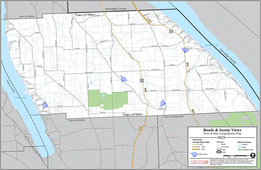
40 Historic and Cultural Resources The Rural-Agrarian Landscape As described by O. D. Von Engeln in his 1988 book The Finger Lakes Region, Its Origin and Environment, the Town of Niles is located in a region that is scenically unique. Von Engeln s description of the geographical environment of the Finger Lakes Region with its general expression wide farm acres and level upland pastures [amid] long, narrow, roughly parallel lakes...with high, almost cliff-steep shores.[and] narrow, deep gorges is an accurate description of much of the landscape in the Town of Niles. Located roughly halfway between NYS Designated Scenic Routes 20 and 90 to the north and south respectively, Niles is among the most picturesque places to traverse in the eastern Finger Lakes. NYS Route 41A originates in the Village of Skaneateles and crosses the Town of Niles to the southeast into Cortland County in the Town of Homer. There are scenic vistas of farmland sloping toward Skaneateles Lake along Route 41A in the Town of Niles, although land use along the northern section of this route is increasingly becoming suburban residential in character. Route 38A bisects the Town between the Hamlet of Mandana just north of Niles and heading south to the Village of Moravia. Route 38A is a scenic two lane rural-agrarian road featuring picturesque rolling farm fields with historic barns and buildings along its course. Several other roads in the Town of Niles feature spectacular scenic views particularly from their heights above the lakes. Some of the most impressive publicly accessible views in the Town are the northeastward view from the summit along Twelve Corners Road of Skaneateles Lake and the surrounding hills, the westward view from Rockefeller Road over Niles farmland and across Owasco Lake of Scipio farmlands, and the historic Hamlet of Kelloggsville surrounded by farm fields on Old Salt Road (see Map 4). Looking northeast from the high point of Twelve Corners Road in the Town of Niles, Town of Niles Comprehensive Plan - January
41 44 Town of Niles Comprehensive Plan - January 2010
42
 and later reelected to Congress (1825).")
43 Historic Resources In the 1850s, fifteen water powered industries lined the banks of Bear Swamp Creek, in the Town of Niles. New Hope Mills is the only factory still in existence on Bear Swamp Creek. The flour mill, still in operation today, was built by Judge Charles Kellogg, a member of the New York State Assembly ( , ) and later reelected to Congress (1825). Judge Kellogg sold the mill to Horace Rounds in 1851, and the mill remained in the Rounds family until The mill was then sold to Howard Weed, Hubert Latta, and Leland Weed becoming New Hope Mills. The mill originally contained three runs of stone and had a capacity of 200 bushels of grain a day. In 1892, the mill began grinding with roller mills which are still in the mill today. The flour mill along with a saw mill a short distance upstream, are known today as New Hope Mills Inc. Although the waterwheel is most visible, the mill s real power came from the water turbine underneath the mill. The turbine could run all year round providing there was sufficient water volume. The mill consistently produced quality flour without pollution because the water was aerated as it passed over the waterwheel or through the turbine, and the wheel did not add petroleum into the water because the wheel bearing is made of wood Lignum vitae which contains a natural lubricant. New Hope Mills in the Hamlet of New Hope, Local history contends that the community of New Hope was given its name from the top of its new flour mill in After the mill s forty-foot, five-sided ridge pole was put in place, a man climbed to the top and threw a gallon jug of whiskey over his shoulder declaring the Town of Sodom be renamed New Hope. New Hope Mills, at Glen Haven Road and NY Route 41A in Niles, was placed on the National Register in New Hope was the workplace of Sampson Eddy ( ) for almost 35 years, an African American born in slavery in Goldsboro, North Carolina. Eddy joined the Union Army during the Civil War and came north to settle in upstate New York when the War was over. Sampson Eddy left a special mark in New Hope due to a remarkable gift he had as a Christian evangelical preacher. When Eddy died, he was buried in New Hope Cemetery immediately south of the mills. Town of Niles Comprehensive Plan - January

44 New Hope Mills Falls, at Glen Haven Road in the Town of Niles features four large waterfalls, of which three are directly accessible. The falls are the result of the two mill ponds that power the mill; an upper mill pond with a twenty-four-foot waterfall before the saw mill, and the lower mill pond before the flour mill which has a twenty-eight-foot waterfall. Water can be stored overnight in the upper pond to run the mill the following day. There is also a small seasonal waterfall downstream from the mill, and numerous smaller cascades along Bear Swamp Creek. Carpenter Falls, 37 acres nestled in the Skaneateles highlands, above Skaneateles Lake, is fed by Bear Swamp Creek, a clear and clean water source in the protected and closely monitored Skaneateles Lake watershed. Forests abundant with oaks, maples, hemlocks, and beech trees cover the sides of the steep surrounding gorge. The Audubon Society has listed the Carpenter Falls area as an important birding area where rare goshawks and cerulean warblers nest. Carpenter Falls, a 90 Ribbon plunge fall, and Angel Falls, a 62 overhanging drop and cascade, are two of the largest waterfalls along the steep drop of Bear Swamp Creek on its way to the west shore of Skaneateles Lake. Once the site of industry and commerce, a trail along the creek to the falls was known as the old jug path where lake side residents travelled to a distillery that was located on the site. Two other waterfalls between 11 and 30 high feature various cascades and chutes not directly accessible from hiking trails. Carpenter Falls is now owned by the State of New York and managed by the NYS Department of Conservation. Old postcard of Carpenter s Fall in the Town of Niles (source: Historic Photos and Maps of New York State, Date Unknown). 48 Town of Niles Comprehensive Plan - January 2010


 Just west of North Glen Haven Road in Niles, is the site of the boyhood home of Millard Fillmore (1802-1816), 13th President of the United States, and signer of Fugitive Slave Act.")
45 The Mid-Lakes United Methodist Church of New Hope at New York 41A in Niles, New York has historic significance as the church of freedom seeker Sampson Eddy a preacher of power and one fervent in prayer. Eddy conducted evangelistic and worship services in local churches and school houses, private homes and camp meetings. In 1936, the local Methodist Church, to which his widow and son still belonged, installed a window in the church in memory of Eddy. 11 The window installed in memory of Samson Eddy in 1936 in the Methodist Church in New Hope, to which Samson Eddy s widow and son stilled belonged, (source: s%20memory%20ververs%20poster.pdf) Just west of North Glen Haven Road in Niles, is the site of the boyhood home of Millard Fillmore ( ), 13th President of the United States, and signer of Fugitive Slave Act. The home was moved to the front of the Purchase family farm barn, but when the barn was about the collapse, the Cayuga County Agricultural Museum salvaged beams from it and then the local fire department burned it down, not realizing the buildings historic significance. 12 New Hope Cemetery in the Town of Niles, Research by Sheila Tucker, Cayuga County Historian. Moravia Republican-Register, February 28, 1936, quoted in Leslie L. Luther, Moravia and Its Past (Moravia: F. Luther and Co., Cayuga County Historian s Offi ce, and Sheila Tucker Town of Niles Comprehensive Plan - January

46 North Glen Haven Road site of the boyhood home of Millard Fillmore, 13th President of the United States and signer of the Fugitive Slave Act. The historic site is now a Town park, Historic Cemeteries in the Town of Niles include New Hope Cemetery, Jayne Cemetery, Westfall Twelve Corner s Cemetery, Hults Cemetery, West Niles Davidson Cemetery, Selover Cemetery, Van Duyne Cemetery, and Conklin Cemetery. 13 Graves marked with the stories of local sons lost in the Civil War may still exist among Niles cemeteries. 13 Cayuga County NY County Historian s Offi ce Cemetery Location Maps (next page), 50 Town of Niles Comprehensive Plan - January 2010
47 Town of Niles Comprehensive Plan - January
48 52 Town of Niles Comprehensive Plan - January 2010

49 Natural Resources and Environment View north from the edge of a farm field above Skaneateles Lake at its southeast end. Carpenter s Point and the Town of Niles in the distance at left. The natural setting of the Town of Niles among rolling hills and winding roads, with open agricultural fields includes uniquely rich wetlands perched high above two of the 11 Finger Lakes in the region and countless streams through steep, forested slopes feeding those lakes. Due to its location amid the eastern Finger Lakes, the Town of Niles has a somewhat extended growing season even though it receives heavy amounts of snow in winter that are typical of Central New York State. The unusual topography of this region results in a great diversity of landscapes and ecological types within relatively small geographical areas like the Town of Niles. Within the boundaries of the Town, there are windy hilltops with expansive views, vast acres of open farmland, limestone cliffs dropping to lakes, deep wooded ravines with cascading waterfalls, maple beech mesic forest, perched wetlands, lowland creeks and sandy beaches. Town of Niles Comprehensive Plan - January
. Note the dramatic topography and steep slopes at the south end of each lake where the headwaters feed these lakes.")
50 Map showing the variations in topography and land cover among some of the Towns in the southeastern end of the Finger Lakes Region of Central New York (green indicated forested areas, tan represents mostly open land). Note the dramatic topography and steep slopes at the south end of each lake where the headwaters feed these lakes. 54 Town of Niles Comprehensive Plan - January 2010


51 Sally Rd [ Valentine Rd Buckley Hill Rd Old Salt Rd Cliffside Dr The La ne Way Twelve Corners Rd Onondaga County E Lake View Dr Town of Owasco Fitzpatrick Rd Rowe Rd Albring Rd DeWitt Rd Meadow Ln Amerman Rd Twisting Ln Longpoint on Owasco Fire Lane 18 Sam Adams Ln Cross Rd Gahwiler Rd Richardson Rd Old S tate Rd [ Fire Lane 21B Carltons Clf Fallbrook Ln F ire Lane 18 Mack Rd Harter Rd Vanderstouw Rd Split Rock Rd Skaneateles Lake Fire Lane 16 F ire Lane 16A Onondaga County State Route 38A Murray Rd Plun kie Pt Widewaters Arnold Rd Derby Rd Appletree Pt L ocust Ln Fire Lane 12 Rockefeller Rd Grange Hall Rd Cream Hollow Rd Eberle Rd Carver Rd Glen Cove Rd Fire Lane 13A Town of Scipio Boscobel Ln Fire Lan e 23 Oak Hill Rd Case Rd Quarry Rd Corrigan Rd [ Fire Lane 13 Fire Lane 24 Granger Hill Rd Burdock Rd New Hope Rd N Glen Haven Rd Fire L ane 26 Robinia Hill R d Ridings Dr Ensenore R d Owasco Lake Hillcrest Dr Dolphin Point Ln Duryea St Glen Haven Rd Globe Rd Burtless Rd Welch Rd Sherwood Rd Casowasco Dr Kennedy Rd Mather Rd Lyons Rd Fire Lane 10A [ State Route 38 Fire Lane 9 Firelane 3 Fire Lane 29 Firelane 30 Fire Fire Lane 31 l ane 1 Indian Co ve Rd Fire Lane 33 Lisa Ln Fire Lane 34 Fire Lane 35 SE On Owasco Rd Town of Moravia Hall Rd Riley Rd Church Rd Jugg St Cheese Factory Rd Decker Hill Rd Murphy Hill Rd Town of Sempronius White Rd New Rd Ganey Rd Sayles Corners Rd Hatheway Rd State Route 41A LEGEND Slope Bear Swamp Rd Town of Niles Comprehensive Plan Low (1% - 3%) Low to Moderate (4% - 6%) Moderate (7% - 12%) Moderate to High (13% - 20%) High (21% - 45%) Slope MAP 5 Curtin Rd Municipal Roads Tax Parcels Towns County Hartnett Rd Smith Ln Data obtained from Cayuga County Planning Department and the United States Geologic Survey. This map was created for planning purposes only. The CNYRPDB does not guarantee the accuracy or completeness of this map. Please see text for full disclaimer. Map created: July 2009 Ridge Rd Natural Features Streams Lake Miles I Reynolds Rd

52 Owasco Lake View southwest of the Town of Niles along Owasco Lake, photo courtesy of Bill Hecht. Carved into the Appalachian Plateau in Central New York State by Pleistocene glaciers, Owasco Lake has a surface area of 10.4 square miles, maximum depth of 177 feet and a watershed area of approximately 205 square miles. In the book Slim Fingers Beacon (1945), Archibald Merrill described Owasco Lake as a sapphire gem of purest ray serene seemingly born to shimmer unseen, away from casual tourist gaze. Around its rugged head stretches the farm countryside where a President of the United States, Millard Fillmore, was born, where an Oil King, John D. Rockefeller, lived as a boy, and a New York State Governor, Enus T. Throop, was given birth. Although Owasco Lake is one of the smallest Finger Lakes, its watershed ranks third of all the Finger Lakes and is comprised of all or portions of fourteen Towns including approximately 2/3 of the Town of Niles. Owasco Lake serves as a drinking water supply to an estimated 58,000 users (some 70% of Cayuga County residents) 14 and is considered to be an exceptional fishery with a variety of species prized for recreational fishing including yellow perch, smallmouth bass, northern pike, lake trout, brown trout, and landlocked salmon. The declining water quality of Owasco Lake in recent years has been a great concern of many residents in surrounding communities, and several studies have lead to a better understanding of issues contributing the decline as well as the implementation of measures such as monitoring and watershed inspection in an effort to reverse downward water quality trends. While Niles is largely an agricultural community with highly absorptive, vegatated land cover in crops with some remaining woodland; demand for lake front access may result in the conversion of large areas of vegetated land to the far less permeable conditions of mown lawn and asphalt drives and roadways. Land use changes, especially the continued loss of forest and shrubland cover on the slopes above the lake in watershed municipalities may result in decreasing percentages of stormwater infiltration to soils and increased run-off to tributaries that feed Owasco Lake, thus negatively impacting water quality in future years. Retaining wooded areas around the lake, encouraging rain gardens, meadows and green roofs, and minimizing road and driveway widths will contribute to higher water quality. 14 Source: State of Owasco Lake Watershed, published by the Cayuga County Soil and Water Conservation District, James Hotaling, Executive Director. Principal Author: Michele Wunderlich, Cayuga County Department of Planning and Development, July 2001 Town of Niles Comprehensive Plan - January

53 Map showing the extent of the Owasco Lake Watershed and Cayuga County Municipalities within the watershed. 58 Town of Niles Comprehensive Plan - January 2010
.")

54 USGS Satellite image highlighted to show at risk forested areas within the Owasco Lake Watershed in the Town of Niles. Retaining forest cover up slope provides free ecosystem services and is key in protecting water quality (Source: Skaneateles Lake and Highlands Skaneateles Lake from the southeast highlands with the Town of Niles shoreline and Carpenter s Point at left. Photo courtesy of Mark Whitmore, Finger lakes Land Trust, Skaneateles Lake, located in the Oswego River Drainage Basin, is the fourth largest of the Finger Lakes and one of the most picturesque of the Finger Lakes. It is a long, narrow lake that occupies a valley with oversteepened slopes in the south that gradually diminishes to the north where the lake meets the Lake Ontario Plain. The lake was formed in the Pleistocene Era by the advance of the continental glacier. Skaneateles Town of Niles Comprehensive Plan - January

55 Lake has a mean elevation of feet above sea level, a length of 16 miles, an average width of three quarters of a mile, and a maximum depth of 300 feet. The unusual ecology of the Skaneateles Highlands overlooking deep blue-green waters of Skaneateles Lake have been said by geologists to give the impression of a glacial fiord. Steep, forested lake valley walls are cut by numerous small ravines, and gorges harboring tiny wetland pockets and intermittent streams with stone cliffs in some areas. There are actively farmed lands on the gentler terrain of a plateau above the steep slopes and the many fields cleared for farming afford spectacular views of the surrounding countryside for which the Finger Lakes Region is famous. A farm field above Skaneateles Lake looking east from Route 41A. The Skaneateles Lake Watershed is comprised of portions of one Village and seven Towns within three counties: Onondaga, Cayuga, and Cortland. The 1/3 of the Town of Niles that is not in the Owasco Lake Watershed, is in the Skaneateles Lake Watershed. A large portion of the watershed is steeply sloped with the highest point of elevation, 1,980 feet at the southeast end. The headwaters of Skaneateles Lake lay in the steep valleys and perched wetlands to the south in the Towns of Niles, Sempronius, Scott, and Spafford. One of the two main tributaries to Skaneateles Lake is Bear Swamp Creek south of Glen Haven Road in the Town of Niles. The highlands encompassing the southern half of the lake include rugged natural areas such as the steep forested valley walls surrounding the lake and Bear Swamp, as well as large tracts of rich farmland that has been under cultivation for generations. The south and eastern portions of the Town of Niles are located within these highlands which have been widely recognized for their scenic beauty and their regional significance. The diverse natural features just to the south of the Town include Bear Swamp, a globally significant wetlands identified by the New York Natural Heritage Program and an Audubon-designated Important Bird Area (IBA) known as the Southern Skaneateles Lake Forest Important Bird Area. This forested area supports at-risk species of birds including the American Bittern, Northern Harrier, several species of Hawks, Thrushes, Warblers and many others. 60 Town of Niles Comprehensive Plan - January 2010

56 Map of the area identifi ed as the Skaneateles Highlands. The yellow line shown as the project boundary also delineates the extent of the Skaneateles watershed in the Highlands. Town of Niles Comprehensive Plan - January

57 Forests on the steep slopes above Skaneateles Lake serve as important buffers by minimizing sediment and nutrient runoff into the lake. Skaneateles Lake is one of only six AA unfiltered water sources serving a major metropolitan area in the United States. The City of Syracuse Water Department has identified the steep forested hillsides surrounding the lake as one of the most important factors influencing water quality. The quality of stormwater run-off from the many creeks and streams in the Highlands is key to maintaining the existing high quality of the lake water. Unchecked erosion, poorly planned land clearing, roadway pollutants, and nutrient run-off from agricultural practices all have the potential to severely impact the quality of this high quality resource. With the exception of existing public and private conservation lands, there are currently no special requirements for the management of these important forested lands. 15 USGS Satellite image highlighted to show some of the forested slopes within the Skaneateles Watershed in the Town of Niles that are so important to preserving water quality in Skaneateles Lake (Source: 15 Source: Auduban Society, le.do?siteid=2807&navsite=state, and Skaneateles Highlands Conservation Planning and Stakeholder Survey Project, Finger Lakes Land Trust and CNY Regional Planning and Development Board, Town of Niles Comprehensive Plan - January 2010
58 Sally Rd [ Valentine Rd Buckley Hill Rd Old Salt Rd Cliffside Dr The La ne Way Twelve Corners Rd Onondaga County E Lake View Dr Town of Owasco Fitzpatrick Rd Rowe Rd Albring Rd DeWitt Rd Meadow Ln Amerman Rd Twisting Ln Longpoint on Owasco Fire Lane 18 Sam Adams Ln Cross Rd Gahwiler Rd Richardson Rd Old S tate Rd [ Fire Lane 21B Carltons Clf Fallbrook Ln F ire Lane 18 Mack Rd Harter Rd Vanderstouw Rd Split Rock Rd Skaneateles Lake Fire Lane 16 F ire Lane 16A Onondaga County State Route 38A Murray Rd Plun kie Pt Widewaters Arnold Rd Derby Rd Appletree Pt L ocust Ln Fire Lane 12 Rockefeller Rd Grange Hall Rd Cream Hollow Rd Eberle Rd Carver Rd Glen Cove Rd Fire Lane 13A Town of Scipio Boscobel Ln Fire Lan e 23 Oak Hill Rd Case Rd Quarry Rd Corrigan Rd [ Fire Lane 13 Fire Lane 24 Granger Hill Rd Burdock Rd New Hope Rd N Glen Haven Rd Fire L ane 26 Robinia Hill R d Ridings Dr Ensenore R d Owasco Lake Hillcrest Dr Dolphin Point Ln Duryea St Glen Haven Rd Globe Rd Bear Swamp Rd Casowasco Dr Fire Lane 29 Firelane 30 Fire Lane 31 Town of Moravia Church Rd Town of Sempronius Burtless Rd Welch Rd Sherwood Rd Kennedy Rd Mather Rd Lyons Rd Fire Lane 10A [ State Route 38 Fire Lane 9 Firelane 3 Fire l ane 1 Indian Co ve Rd Fire Lane 33 Lisa Ln Fire Lane 34 Fire Lane 35 SE On Owasco Rd Hall Rd Riley Rd Jugg St Cheese Factory Rd Decker Hill Rd Murphy Hill Rd White Rd New Rd Ganey Rd Sayles Corners Rd Hatheway Rd State Route 41A Hydrology Streams Lakes 100 Year Flood Zone Wetlands & Floodplains Town of Niles Comprehensive Plan State Identified Wetlands Federally Identified Wetlands MAP 6 Curtin Rd Other Roads Tax Parcels Towns County Miles Hartnett Rd Smith Ln Data obtained from Cayuga County Planning Department and New York State Department of Environmental Conservation and United States Fish and Wildlife Service. This map was created for planning purposes only. The CNYRPDB does not guarantee the accuracy or completeness of this map. Please see text for full disclaimer. Map created: July 2009 Ridge Rd I Reynolds Rd
, the Town of Niles may be presented with opportunities to take advantage of this resource for commercial,")
59 Wind & Wind Energy Wind energy is a renewable resource that is abundant in Cayuga County. With significant areas of good power density class ratings (available wind energy), the Town of Niles may be presented with opportunities to take advantage of this resource for commercial, community-based, or on-site wind turbines. With the cost of non-renewable energy resources becoming increasingly costly, renewable resources such as wind can help to boost local economic development while contributing to resource conservation and the mitigation of global warming. The open, agricultural landscape throughout the Town of Niles may present potential aesthetic challenges to the siting of wind turbines.there are techniques for assessing and mitigating visual impacts of Small Wind Energy Systems (SWES). The Town may want to consider establishing overlay districts that define where (taller) wind energy systems may be appropriate; or to identify particular locations for these facilities on certain educational, industrial, or municipal land; or to discourage them within historic districts or sensitive habitat areas. In areas where there are distinctive scenic vistas, landscapes, and roadways, municipalities can consider prohibiting facilities of this kind. Alternatively, important viewsheds that have been identified may be protected by locating turbines toward the edges of the viewshed. A municipal scenic resource inventory and evaluation offers many benefits including determining which significant local areas merit some protection. Town of Niles Comprehensive Plan - January
60 The Marcellus Shale & Natural Gas Marcellus Shale, also referred to as the Marcellus Formation, is a Middle Devonian-age carbonaceous shale that occurs in the subsurface beneath a large swath of the northeastern U.S. The Town of Niles is located entirely within the Marcellus Formation which is estimated to contain an undiscovered resource of about 1.9 trillion cubic feet of natural gas. Natural gas occurring within the Marcellus Shale can be difficult to extract through tiny disconnected pore spaces, but recently energy companies have begun to employ a new extraction technique known as hydraulic fracturing that creates fractures in the shale and allows the gas to flow more readily through the rock and into a well bore. This extraction method involves high-pressure and high volumes of water, and a chemical gel injection to induce fractures in the rock surrounding the well bore to increase the flow of gas to the well. The hydraulic fracturing method for gas extraction in New York State is currently under review by the NYSDEC. Comments on NYSDEC s draft Supplemental Generic Environmental Impact Statement were submitted in December 2009 by the Federal Environmental Protection Agency (EPA) citing concerns about potential impacts to human health and the environment that warrant further scientific and regulatory analysis. Of particular concern to EPA were issues involving water supply, water quality, wastewater treatment operations, local and regional air quality, management of naturally occurring radioactive materials disturbed during drilling, and cumulative environmental impacts of hydraulic fracturing for natural gas extraction. Natural gas is a highly valuable resource and royalties to property owners from a well yielding over one million cubic feet of natural gas per day can be very high. Some landowners in the Town of Niles have already entered into lease agreements for research and development of gas production on their land. It is likely that additional leases will be pursued in the Town in the future. In addition to protecting vulnerable water supplies, communities located within the targeted region may want to review local regulations to assure protection from environmental impacts such as air-born emissions and impacts to existing rural character. New pipeline systems, wastewater (flowback) storage tanks, 24/7 noise and lights, as well as significantly increased truck traffic on local roads are some of the potential impacts on existing rural character of hydraulic fracturing for natural gas. 66 Town of Niles Comprehensive Plan - January 2010

61 A farm in the Town of Niles, date unknown (source: Historic Photos and Maps of New York State, Agriculture and Open Space The practice of farming in Niles has historically been a key component of the Town s character and economy. In past years Niles farms produced crops primarily for human consumption including red kidney beans, black turtle beans, sugar beets, sweet corn and buckwheat. Today, field crops produced in the Town of Niles include grain corn and soybeans for animal consumption, hay, barley, winter wheat grain and straw, and rye straw. Since its invention late in the eighteenth century, Niles farmers have used the moldboard plow to turn the soil along with disking, dragging or chisel plowing. Today, Niles farms employ a zone-till, no-till, minimal till, or conventional till method for conventional, natural, and organic agricultural crop production. Technological changes in agricultural practice in recent decades have included biological engineering, chemical inputs, and considerable advances in farm machinery. Since 1993 the use of bovine somatotropin (BST) a synthetic hormone that may increase milk production has been common in dairy production; and in 1996, Genetically Modified Organisms (GMOs) were introduced across the U.S. in agricultural production of corn, soybeans, cotton, and milk. These trends underscore the dilemma farmers face over production and pricing requirements that are increasingly challenging to meet, even as there has been cause for concern over the potential long-term effects of genetic modification of crops and hormones in food supplies. Environmental Best Management Practices (BMPs) in farm management that strive to protect Niles natural resources and are used faithfully can assure that farming is good land stewardship practice. High quality agricultural soils continue to be an important natural resource in the Town of Niles. Diverse and sustainable practices in farming open land also contribute to high aesthetic values associated with scenic farmland views from surrounding lands, and in addition provide an important source of food and forage for migrating birds and pollinator species. The working farms that continue the practice of agriculture in Niles today continue to give the community its much valued rural-agrarian character. Town of Niles Comprehensive Plan - January
62 Nearly all of the Town of Niles is located within an Agricultural District. Agricultural Districts provide protection from conflicting land uses and demonstrate a commitment to the future of the community s farming industry. In New York State, Agricultural Districts must predominately consist of viable agricultural land; more than fifty percent of the land must be in farms. The identification of Agricultural Districts helps keep lands in production, municipalities manage growth and development; and communities maintain their rural character, and scenic landscapes. Cayuga County has a Farmland Protection Program and administers six NYS-certified Agricultural Districts, assisting local municipalities with land use planning, supporting agricultural economic development, and working with local farmers to develop alternative energy sources including ethanol and methane in addition to supporting the growth and enhancement of local farmers markets. In the Town of Niles, most land is included in Cayuga County Agricultural District 6, one of six agricultural districts containing a total of 364,617 acres. Agricultural District 6, comprised of 82,142 acres, is the most recent agricultural district to be established in Cayuga County in 1981 and is currently under review. Proposed changes to the six agricultural districts in the County are primarily concerned with consolidation of the six separate County districts into three County districts. Agricultural District 6 parcels in Niles range in size from less than 1 acre to over 239 acres, but the largest number of acres on any one parcel that is currently farmed is 161. The increase in the scale of agricultural operations in recent years has raised concerns about associated impacts of manure spreading and nutrient runoff to Skaneateles and Owasco Lakes. The Skaneateles Lake Watershed Agricultural Program and its recommendations have been implemented by many farms in the Town of Niles to help preserve and improve the quality of the water in these two lakes. In 2008, the Cayuga County Soil and Water Conservation District launched an Agricultural Environmental Management (AEM) program to assist county farmers in improving their environmental stewardship as well as economic viability. The vision of the AEM program is to have a strong, progressive and sustainable farming sector in Cayuga County through a voluntary method of assessment, planning, implementation and education addressing natural resource concerns related to agriculture. Some farms in the Town of Niles are currently implementing AEM program Best Management Practices (BMP s). The Niles community survey revealed a desire to protect both agricultural lands and open space. To address this community desire, the Town may consider establishing a local Conservation Advisory Council (CAC) to research, inventory and map open space, agricultural lands, scenic views and corridors, and historic resources in the Town. In addition, the Town might consider setting a required minimum acreage for preservation for agriculture, especially those areas featuring prime agricultural soils, or open space in areas identified as priority areas for conservation. Lands identified as dedicated open space could be permanently protected from future development through conservation easements, purchase of development rights programs, or other protective land use tools. Two priority conservation projects listed in the 2006 New York State Open Space Conservation Plan are located in the Town of Niles: the Carpenter Falls/Bear Swamp Creek Corridor; and as part of a regional priority, the Finger Lakes Shorelines and Wetlands. 68 Town of Niles Comprehensive Plan - January 2010
63 Map showing the location of six current agricultural districts in Cayuga County (Source: Cayuga County Planning, 2009). Town of Niles Comprehensive Plan - January
.")
64 70 Map showing the proposed consolidation of the six existing agricultural districts in Cayuga County into three agricultural districts (Source: Cayuga County Planning, 2009). Town of Niles Comprehensive Plan - January 2010

65 Sally Rd [ Valentine Rd Buckley Hill Rd Old Salt Rd Cliffside Dr The La ne Way Twelve Corners Rd Onondaga County Inset Map of Glen Cove Skaneateles Lake E Lake View Dr Town of Owasco Fitzpatrick Rd Rowe Rd Albring Rd DeWitt Rd Meadow Ln Amerman Rd Twisting Ln Glen Cove Rd Longpoint on Owasco Fire Lane 18 Sam Adams Ln Cross Rd Gahwiler Rd Richardson Rd Old S tate Rd [ Fire Lane 21B Carltons Clf Fallbrook Ln F ire Lane 18 Fire Lane 13A Mack Rd Harter Rd Vanderstouw Rd Split Rock Rd Skaneateles Lake Fire Lane 16 F ire Lane 16A Onondaga County State Route 38A Murray Rd Plun kie Pt Widewaters Arnold Rd Derby Rd Appletree Pt L ocust Ln Fire Lane 12 Rockefeller Rd Grange Hall Rd Cream Hollow Rd Eberle Rd Carver Rd Glen Cove Rd Fire Lane 13A Town of Scipio Boscobel Ln Fire Lan e 23 Oak Hill Rd Case Rd Quarry Rd Corrigan Rd [ Fire Lane 13 Fire Lane 24 Granger Hill Rd Burdock Rd New Hope Rd N Glen Haven Rd Fire L ane 26 Robinia Hill R d Ridings Dr Ensenore R d Owasco Lake Hillcrest Dr Dolphin Point Ln Duryea St Glen Haven Rd Globe Rd Burtless Rd Sherwood Rd Casowasco Dr Church Rd Jugg St State Route 41A Bear Swamp Rd Ridge Rd Mather Rd [ State Route 38 Hall Rd White Rd Welch Rd Lyons Rd Fire Lane 29 Firelane 30 Fire Lane 31 Town of Moravia Murphy Hill Rd Town of Sempronius Land Use & Agricultural Districts Town of Niles Comprehensive Plan Kennedy Rd Fire Lane 10A Fire Lane 9 Indian Co ve Rd Fire Lane 33 Lisa Ln Fire Lane 34 Decker Hill Rd Inset Map of the Hamlet of New Hope State Route 41A Bear r Swamp C Ganey Rd Land Use Agricultural Residential Vacant / Unused Commercial MAP 7 Towns I Miles Firelane 3 Fire l ane 1 Fire Lane 35 SE On Owasco Rd Riley Rd Cheese Factory Rd New Hope Rd Glen Haven Rd rreek New Rd Sayles Corners Rd N Glen Haven Rd Recreation/Entertainment Community Service Industrial Public Services Forested/Conservation Curtin Rd Cayuga County Agricultural District Data obtained from Cayuga County Planning Department and the New York State Office of Real Property Services. This map was created for planning purposes only. The CNYRPDB does not guarantee the accuracy or completeness of this map. Please see text for full disclaimer. Map created: July 2009 Smith Ln Hatheway Rd Reynolds Rd Hartnett Rd


66 TOWN OF OWASCO Owasco TOWN OF SKANEATELES ONONDAGA COUNTY ROWE R D 38A Niles DEWITT R D KAHLER LN AMERMAN RD 41A Skanea teles Lake 41 Long Pt. CROSS RD GAHWILER RD Fallbrook Pt. F.L. 18 SAM ADAMS LN VALENTIN E RD FITZPATRICK RD HARTER RD RICHARDSON RD SPLIT ROCK RD MACK RD F.L. 16 Carpenter Pt. MUR RAY R D DERBY RD Adams Pt. Seward Pt. BOSCOBEL LN F.L. 23 ROCKEFELLER RD OAK HILL RD CASE RD GRANGE HALL RD QUARRY R D VANDERSTOUW RD CREAM HOLLOW RD 38A TWELVE CORNERS RD BURDOCK RD OLD SALT RD NEW HOPE RD 41A New Hope CARVER RD N GLEN HAVEN RD GLEN COVE RD BEAR SWAMP RD Gregory Landing Glen Cove LAKE RIDGE LN Threemile Pt. F.L. 26 CORRIGAN RD N GLEN HAVE N RD Owasco Lake 38 Rice Pt. Dolphin Pt. F.L. 29 DURYEA ST TOWN OF MORAVIA CHURCH RD GLOBE RD Kelloggsville TOWN OF SEMPRONIUS RIDGE RD Farmland Classification of Soils Town of Niles Cayuga County, New York Sources: Prime Farmland Prime Farmland if Drained Farmland of Statewide Importance Not Prime Farmland Digital Soil Survey Geographic (SSURGO) database for Cayuga County, USDA Natural Resources Conservation Service, National Map Unit Interpretation Record (MUIR) Database, USDA Natural Resources Conservation Service, Cayuga County G I S Cayuga County Department of Planning and Economic De velopment Miles


67 Public Parks, Recreation and Protected Areas Public lands in the Town of Niles include the Behar Nature Preserve, Carpenter Falls, and Frozen Ocean State Forest. The Bahar Nature Preserve, a 52-acre preserve purchased by the Finger Lakes Land Trust in 1998, is located along Bear Swamp Creek on the western slope above Skaneateles Lake. The land was purchased by the State of New York to protect the area from development, and the waterfront and forest is accessible to those who come to enjoy the preserve s natural beauty. Although most evidence of an old mill disappeared when the lake level rose in the 1800 s; a former sluiceway remains to guide hikers up to a knoll shaded by hemlock trees. From the knoll there is a wonderful view of the 100-foot-deep Bear Swamp Creek ravine. The preserve extends across the creek and up the opposite slope. Upstream beyond the preserve boundary, Bear Swamp Creek cascades over Carpenter Falls. A carpet of mosses and ferns such as shining clubmoss and maidenhair fern add to the lush forest vegetation. White trillium and Jack-in-the-pulpit are among the woodland wildflowers. The Bahar Nature Preserve also includes a 65-foot crescent of shorefront on Skaneateles Lake. In 1904 this same location was known as New Hope Landing, one of two places along the Skaneateles shore where steamboats on lake excursions frequently made a stop in the Town of Niles. The landing featured an inclined ramp connecting the shore with a floating dock that was also used to launch canoes and small rowboats. Although the shoreline of the Bahar Preserve remains in public ownership, an access ramp and dock are no longer in place. The rocky shore in this location makes it a challenging place to access the lake, or beach a canoe or kayak near the trail into the preserve. ( The Bahar Nature Preserve features a unique ecology and dramatic geologic features that draw visitors to explore the beautiful, but uninterpreted preserve along undeveloped hiking paths on the hillside above Bear Swamp Creek. The Preserve is currently managed by the NYS Department of Conservation. 16 New Hope Landing, c.1911 (left). The same location at the shorefront of the Bahar Preserve, 2009 (right). 16 Friends of Reinstein Nature Preserve in Cheektogwa, NY provide an example of a successful NYS DEC partnership with community non-profi t groups committed to improved resource management and interpretation (see: The Town of Marathon, NY recently received a $515K grant through the NYS Department of State Division of Coastal Resources - Local Waterfront Revitalization Program (LWRP) (see: NYS Offi ce of Parks, Recreation and Historic Preservation also offer grants to communities for trail development through the federally funded Recreational Trails Program (see:. Town of Niles Comprehensive Plan - January


68 Frozen Ocean State Forest encompasses 754 acres of land in the Town of Niles and is situated on one of the highest points in Cayuga County. The New York State Department of Environmental Conservation manages Frozen Ocean State Forest which was acquired by the state in purchases made during the 1930s and also as recently as the 1990s. The name is said to have originated from the fact that during the winter season, extremely cold winds sweep across the land turning the woods into endless stretches of frozen forest, the way that the ocean stretches endlessly across the horizon seemingly frozen in time. The forest is comprised of northern hardwood, hemlock, European and Japanese larch, Norway spruce, red pine and white spruce providing a wide range of diverse habitats that allow many species to call the area home. The forest s primitive nature provides excellent hunting and trapping opportunities, as well as true roughing it camping experiences. Frozen Ocean State Forest offers year-round recreational opportunities including hiking, cross-country skiing, hunting, trapping, and of course nature viewing. There are several trails designated for the public s enjoyment including a hiking trail and a cross-country ski trail. One trail from Quarry Road runs east for about 1/4 mile to an 11 acre pond. There is also a foot trail leading west to a scenic 16 acre pond. Two glistening ponds offer visual relief from the endless stretches of trees and a wonderful environment in which to cast a line. The ponds attract the local wildlife, and there are many varieties of plants and wildflowers. 17 ( Left) A pond at Frozen Ocean State Forest in Niles, 2008, (Center & Right) Camp Y Owasco and Yaiewano Program Center in Niles. Camp Y-Owasco, a YMCA Camp is located along the east shore of Owasco Lake, and offers limited camping use to YMCA members. Specialized sports camps combine instruction and games under the direction of high school and professional coaches. Camp Y-Owasco is nestled on 35 acres of fields, woods and hills on the east shore of Owasco Lake, approximately 8 miles south of Auburn feet of shoreline provide the setting for a variety of aquatic programs, while the unspoiled terrain provides a natural backdrop for outdoor play and learning. An A-frame lodge and cabins provide shelter, while platform tents equipped with bunks and mattresses become home for the campers. 18 Camp Rotary, located on 29 acres on Owasco Lake in Niles, NY. is a Cub Scout summer camp that offers year-round camping, tent campsites, lean-tos, rowboats and canoes. 19 Currently, a merger of the Cayuga and Seneca County chapters of the national organization has led to uncertainty as to the specific future use of the site. The Girl Scouts of NYPENN Pathways maintains Yaiewano Program Center also located in the Town of Niles on Owasco Lake with activities offered to include girls from ages Source: 18 Source: 19 Source: 20 Source: 76 Town of Niles Comprehensive Plan - January 2010
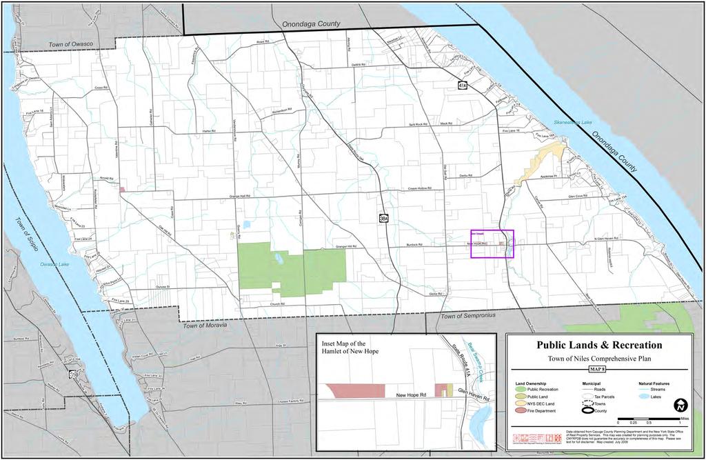
69
 The Finger Lakes Region The Town of Niles is located in Cayuga County in the eastern Finger Lakes Region of Central New York State.")
70 Regional Influences (Source: les/map_region_fl.pdf) The Finger Lakes Region The Town of Niles is located in Cayuga County in the eastern Finger Lakes Region of Central New York State. The Finger Lakes Region, approximately midway between New York City and Niagara Falls, encompasses 14 counties with 11 lakes ranging in size from 11 to 40 miles in length with more than 650 miles of shoreline. Located in the triangle formed by the cities of Rochester, Syracuse and the Corning/Elmira area, the region is bordered by Pennsylvania to the south and Lake Ontario to the north. Lakes in the region include Canandaigua, Cayuga, Owasco, Keuka, Seneca, Skaneateles, Canadice, Conesus, Hemlock, Honeoye and Otisco. The names of these lakes reflect the region s rich Native American heritage. The region draws visitors from all over the world to experience Finger Lakes Region Wines, stunning rural scenery, historic villages, beautiful waterfalls, and recreational opportunities that abound throughout the area during all four seasons of the year. Town of Niles Comprehensive Plan - January


71 Niles is located less than 20 miles south of the New York State Thruway and 10 miles west of Interstate Route 81 just west and south of the crossroads of Central New York at Syracuse. The nearest railroad to the Town of Niles is the Finger Lakes Scenic Railway offering limited passenger excursion service between Syracuse and Victor New York with a stop at Skaneateles Junction about 14 miles to the north of Niles. The railway is a part of the Empire Link, a collaborative business arrangement between Norfolk Southern Corporation and ten short line railroad members of the American Short Line and Regional Railraod Associations Eastern Region with limited seasonal east/west passenger service between Syracuse and Victor New York. The railroad collaborative has also allowed the conversion of short haul truck traffic to rail, an attractive option for shippers in New York, Pennsylvania and New Jersey by using excess freight capacity on these lines. Amtrak offers daily service to major cities throughout the region from Syracuse, about 32 miles away. Map showing the Empire Link, a collaborative system of short line railroads in the Central New York Region (Source: 80 Town of Niles Comprehensive Plan - January 2010

72 There are no airport facilities in the Town of Niles. The Skaneateles Aerodrome, a small regional airport is located in Skaneateles and the Ithaca/Tompkins Regional Airport is located just northeast of Ithaca, New York. Hancock International Airport is located in Syracuse, New York. Cayuga County is one of 23 counties traversed by the Erie Canalway National Heritage Corridor, a 524 mile-long scenic navigable waterway constructed in 1825 connecting the Great Lakes of New York State with the Atlantic Ocean at New York City via the St. Lawrence Seaway and the Hudson River. The federally designated National Heritage Area features cultural events and festivals along its route as well as an off-road multiple-use trail currently in development that will stretch 350 miles when completed and become the longest such trail in the nation. The Canalway Trail will be open to hikers, joggers, bicyclists, and cross country skiers connecting hamlets, villages and cities across New York State. Map showing the location of the Town of Niles in relation to the central portion of the Erie Canalway National Heritage Corridor indicated by the green shaded area (Map courtesy of the National Park Service). The Town of Niles is just about ten miles to the south of the picturesque Village of Skaneateles, a popular tourist stop bustling with activity. Daily scenic boat tours operate seasonally from the Village of Skaneateles heading south on Skaneateles Lake offering and stunning views of farmland and wooded slopes along the eastern edge of the Town of Niles which once provided a stop on the lake excursion route at New Hope Landing near Carpenter s Point. Town of Niles Comprehensive Plan - January
73 Sixteen major cities lie within 500 miles of the Town of Niles including New York City (239 miles), Boston (348 miles), Baltimore (324 miles), Pittsburgh (348 miles), Toronto (200), Rochester (74 miles), and Syracuse (25 miles). Immediate support industries in Cayuga County include trucking, warehousing and an array of small manufacturing facilities. For employment, entertainment, and other needs, the Town of Niles has easy access to the cities of Auburn (12 miles), Cortland (24 miles), and Ithaca (32 miles) away. The Town of Niles is within easy commuting distance of several state and private Colleges and Universities including the following: Cayuga County Community College Cornell University Hobart and William Smith Colleges Ithaca College Le Moyne College Monroe Community College Onondaga Community College Nazareth College Rochester Institute of Technology (RIT) St. John Fisher College SUNY Cobleskill SUNY College of Environmental Science & Forestry (ESF) SUNY - Cortland SUNY Health Science Center SUNY Morrisville SUNY - Oswego Syracuse University Tompkins County Community College University of Rochester Wells College Land Use Regulation The Town of Niles established a Town Planning Board in the fall of 1986 and also has an Appeals Board. Under existing subdivision regulations the Planning Board reviews and regulates the following: public street and road design, sanitary sewer design, water system design, stormwater quality restrictions, stormwater drainage design, slope restrictions, erosion and sediment control, lake rights conveyance, and shared lakefront recreation. The Town has adopted a State Environmental Quality Review Act (SEQRA) law to ensure appropriate consideration of environmental impacts resulting from concentrated development. A Plan for the Town of Niles, Cayuga County N.Y. was compiled and adopted by the Town in August of The 1987 Plan described an emerging consensus that a minimal set of regulations should be developed to achieve the basic objectives of the Town. The guidelines for future growth and development in the Town of Niles became the municipal code, published in the year 2000 and updated in The Code of the Town of Niles includes Chapters regarding Setbacks and Lot Sizes, Site Plan Review, and Subdivision of Land, in addition to general and administrative legislation for the Town. The Town has a lot size law with a 82 Town of Niles Comprehensive Plan - January 2010
74 2-acre lot minimum. The exception to this law are lake front lots on Owasco and Skaneateles Lakes, which have a minimum of 15,000 sq. ft. and a minimum of 75 ft. of lake frontage. The setback on lake front lots is a minimum of 25 ft. from the mean high water mark. A new local law (2-2008) was adopted by the Town of Niles in 2008 to allow the Planning Board to review and regulate lake rights conveyance and all shared lake front recreation along the shorelines of Skaneateles and Owasco Lakes in the Town. The law allows the granting of special permits for shared lakefront recreation (deeded lake access rights) with a minimum of 10 of shoreline and 2,000 sq. ft. of lot area on the shared lakefront recreation parcel (per dwelling unit) in lake front or inland developments. The law also allows modifications to these dimensional requirements for lakefront parcels over 20,000 sq. ft. or with over 200 feet of shoreline with some additional mitigating measures. To illustrate how the law, as written, could translate to allowed development in the Town, the following example is given: A proposed development of 40 homes (160 people and associated boats, vehicles, etc.), could be approved for a parcel along the lakefront or up slope on an inland parcel that would grant deeded lake access for all of these dwellings to 400 of lake shorefront. With nearly 10 miles of lake shorefront, and spectacular upland views from existing Niles farmland and open space, the existing 10 shoreline minimum has the potential to result in approximately one 20 home development every ¾ mile along each lake (if just 5% of Niles shore front land is developed as shared lake front recreation). Considering the community s primary concerns (from the survey conducted for this Plan) about water quality, loss of open space and farmland, the Town may wish to review and revise Local Law to effectively address the community s goals listed in Chapter 1 of this Plan. 21 Municipalities employ a range of methods to help them reach their land use goals. One method is the use of regulatory tools such as legislation in the form of local laws. Land use issues are addressed on an individual basis, i.e. subdivision regulations, mobile home regulations, outdoor entertainment regulations, etc. These laws are generally drawn up by the Planning Board, submitted for public hearing, and enacted by a vote of the Town Board. The Town of Niles has historically used and currently uses this form of land use regulation. Another common method of regulating land use is through the creation of zoning districts. Areas of the Town are divided into districts, or zones, for particular, or combinations of uses, i.e. agricultural, residential, commercial, industrial, historic, mixed use, etc. Zoning can be used to screen out incompatible land uses, as well as to encourage and control favorable land use practices. Another important tool many communities use for review and approval of development proposals is Site Plan Review. The Town of Niles currently has a Site Plan Review law through which commercial development in the Town is regulated. Site Plan Review can also be used to regulate housing development to encourage open space preservation. 21 Lake area land use regulations and Best Management Practices (BMPs) developed to prevent degradation of water quality and encourage preservation of open space are most effective when based on an Environmental Carrying Capacity Study. Typically, effectively constructed regulations require a minimum of 70 of shorefront per dwelling unit. Even with a 70 shorefront minimum, at a 5% conversion of waterfront land to shared lake front development could result in 10 new homes for every 2 ½ miles of Niles shoreline. Town of Niles Comprehensive Plan - January
75 Both zoning regulations and local laws provide relief from the strict application of regulations through the granting of variances (for use or area). A variance is the granting of permission by the administrative body (Board of Appeals or Zoning Board of Appeals) to use the land in a manner that is not in accordance with, or is prohibited by the local law or zoning regulation. The granting of variances is not automatic; the property owner seeking relief is expected to provide reasonable argument as to why the law or regulation should be waived in their particular situation, and the variance may or may not be granted, depending upon the decision of the Board. Land use regulation in the Town of Niles should be carefully constructed to effectively balance the management of land uses with the individual rights of the property owner; to protect the community s rural-agrarian identity; encourage smart growth; preserve agricultural and open lands; protect and improve the quality of water resources; and encourage revitalization and preservation of culturally-valued historic buildings, structures and landscapes. At present, the Town of Niles has no existing zoning laws, and the Towns setback and lot area regulations were developed and adopted over twenty years ago. There are special purpose regulatory tools listed below that can help the Town to achieve identified community goals including protecting valuable community resources. Some of the special tools the Town of Niles should consider using to help protect agricultural, water, ecological, historic, and scenic resources may include: special districting or overlay zones that can provide added protections to existing requirements for sensitive areas such as historic areas and stream corridors; business improvement districts; purchase or transfer of development rights programs (PDRs or TDRs); conservation subdivision design; and scenic or agricultural easements. Subdivision of Land Conventional subdivision regulations currently in use in the Town of Niles may not support the community s desire to protect the rural-agrarian character of the Town. A conservation analysis prior to site plan layout could be very beneficial. This would include identifying the location of any significant natural or cultural resources on a sketch plan, followed by a dialogue between the property owner (or developer) and the planning board about the conservation value of the lands proposed for development. The conservation method of subdivision of land is intended to allow an opportunity to preserve or protect natural, scenic, historic, or cultural features of value to the community while also allowing flexibility and an opportunity for developers to initiate creative solutions to protecting important community resources (i.e. steep slopes, scenic views, prime agricultural soils, trail corridors, stream corridors, wetlands, woodlands, historic sites, stone walls, etc.). Smart planning strategies such as conservation subdivision design result in far less open land being consumed by development, and much less money spent by municipalities on infrastructure and community services than would be spent as a result of conventional subdivision design. Environmental Stewardship and Water Quality Protection Protection and preservation of natural resources was identified as important to the Niles community, and is critical to sustain and improve the community s environmental, social, and economic health. Development of a community natural resources map with the location of all known valuable natural resources is the crucial first step in the protection of these vital community assets. Natural resources include the lakes, stream corridors, agricultural lands, beaches, wetlands, watershed areas, vegetation communities, trees, woodlands, swamps, meadows, wildlife habitats, soils, geology, steep slopes, ridgelines, and aquifers. 84 Town of Niles Comprehensive Plan - January 2010
76 In order to protect valued water resources, the Town may consider developing and adopting a Water Resources Protection Plan that identifies potential sources of pollution and sedimentation of lakes and streams including lands directly contributing storm water run-off to streams and erosion prone slopes. Such a plan might include recommendations for Best Management Practices (BMP s) in land management to prevent future pollution of the community s water resources. The establishment of protective overlay zones along stream corridors, steep slopes, and lake shore areas to limit development and retain vegetated cover in these areas would minimize sedimentation and nutrient run-off to lakes and help to protect fish spawning areas, aquatic life, wildlife habitat, and water quality. Economic Development In 2008, among the eleven economic regions in the State of New York, the Finger Lakes Region ranked fourth in tourism/visitor spending after New York City, Long Island, and Hudson Valley. Visitors to the Finger Lakes Region spent $2,671,392 in 2008 supporting the employment of 57,416 people in the region. This positions the Finger Lakes third out of eleven regions in visitor-related employment only following NCY and Long Island. Although the portion of this employment benefit in Cayuga County is only 4.9%, the potential for the expansion of visitor-related economic development in the County and in the Town of Niles is very real. 22 Economic growth in the Town of Niles and its hamlets are interdependent. A vibrant hamlet economy spurs Town-wide economic opportunity, and additional economic opportunity in the Town brings life to the hamlet. Revitalized hamlet business districts, including protection and restoration of the historic buildings, and context sensitive infill would encourage the sustainability of these unique areas; increase the variety of goods and services available to residents, and could potentially attract visitors to the Town of Niles and its hamlets to experience the traditional rural setting and unique sense of place. Mixed uses are appropriate in hamlet areas with hamlet-scale commercial/retail and business/professional uses in combination with upper floor residential units. Development in the hamlets should meet clear, form-based architectural review standards that are consistent with the scale and character of the historic hamlet form. Recreation and Tourism The identification and acquisition of land for the development of additional community recreational facilities, including waterfront access at the Skaneateles Lake and Owasco Lake shores, is a need and desire expressed by community members in the survey conducted for the development of this Comprehensive Plan. This supports the Town s consideration of a future plan to provide universally accessible facilities for public access at both lakes. A system of well-marked interconnected greenway trails and bike paths that could provide a community-wide link to public, recreational and historic resources in the Town of Niles. 22 (Sources: The Impact of Tourism in New York State, April 2009, Tourism Economics, Town of Niles Comprehensive Plan - January
77 Appendix B Visioning Sessions, Survey & Results The following series of public visioning and input sessions were held in two separate locations over a six (6) month period to seek the community s input, perception and ideas for the future of the Town of Niles: Visioning Session #1 March 24, 2007 Special Topic Agriculture Visioning Session #2 April 26, 2007 Special Topic Land use Regulations in Niles Visioning Session #3 July 21, 2007 Special Topic Lake and Watershed Issues Visioning Session #4 August 18, 2007 Special Topic Owasco and Skaneateles Lakes With input from the visioning process, the Comprehensive Planning Committee formulated a survey which was then mailed to 900 Town residences. The intent of the survey was to seek out public opinions on the Town of Niles at present, and how to address the future of the Town. Analysis of the results of both the written community survey, and comments from the community visioning process formed the basis for this comprehensive plan. Results of Visioning Session I March 24, If you were trying to get a friend that lives a great distance away to come to the Town of Niles, what would you say to encourage them? Rural character, friendly/down to earth people, lake views, outdoor recreation (i.e. Bear Swamp), fi shing opportunities, quiet, relaxing atmosphere Enjoying tranquility of rural living, enjoy the rolling hills with farms, woodlands, and residences Know your neighbors, welcoming area Pretty lakes, open land, open country Rural, peaceful Rural atmosphere, lakes, outdoor recreation activities, peace and quiet, limited amount of traffi c Rural setting, reasonable tax base Scenic views, close neighbors, close to major hospitals and food markets Rolling hills, beautiful location within the Finger Lakes, rustic settings, quaint areas Country setting, beauty, the fall colors Quiet neighborhood, nice scenes Skaneateles lake, open space, fresh air, gorgeous views, relaxed way of life, closeness to mother nature and her fi nest offerings In the country, beautiful views, quiet, neighborly It is a peaceful, beautiful areas and in this crowded world we appreciate it Skaneateles Lake boating, cross country skiing, schools, agriculture Hunting, fi shing, relaxation, camping, boating Rural, conservative, everything we need is here (church, ambulance, good roads, friendly people), great scenic views Elbow room, peaceful, restful, scenic Quiet, open spaces, spectacular views, lots of snow for winter sports, fi shing, boating, water sports 86 Town of Niles Comprehensive Plan - January 2010
78 I was born here, I am connected to my land, scenic views are beautiful, the winters are great I wouldn t necessarily encourage them to come, but if I was it would be because it is beautiful, peaceful, and quiet. They would probably rather visit a friend in Skaneateles which is fi ne with me. Best time is after Labor Day before June. Beautiful views, wonderful summer weather, low/no crime, relatively low cost, good schools, wonderful neighbors, great soil Beautiful lakeshore, good neighbors, laws in place to control random growth Because the town and the Syracuse Water Authority, has in place regulations that control random growth or unplanned growth and regulations that prevent water pollution of both lakes Open space, beautiful farmland, privacy the right to do what you want with your own land Quiet place to live with good neighbors for the most part Rural, farms Beautiful countryside, lakes!!, recreational opportunities, relaxing, calm, peaceful, friendly people, low cost of living (comparatively) Great rural area, good hunting and fi shing, friendly atmosphere, safe community We spend a lot of time fi shing, hunting, boating, and good looking sights Great views, scenery, fi shing, biking, boating Proximity to Skaneateles, proximity to downhill and cross country skiing A peaceful, relaxed and beautiful countryside with rolling hills and crystal blue lakes, neighbors very nice Peaceful and cozy Not many intrusive rules, farther from main cities Historically quiet country, open spaces, lots of creeks, springs, low crime, small town Situated between two of the prettiest glacially formed Finger Lakes Come here for some great outside activities, clean air, no traffi c, walks on country roads, you will see wildlife and country homes Niles is rural, scenic, mostly quiet, but easy to get to Auburn, Skaneateles, Moravia, etc. for shopping, entertainment, etc., very centrally located Clean air, great views, lakes cool in summer (need to be cleaner), country setting, access to theater, NYC, eastern sea coast, cultural hubs, great shopping GROUP DISCUSSION: Know who your neighbors are, wonderful neighbors, great soil, good schools, beautiful views, regulations in place for growth and to keep the lakes clean, seasonal changes are beautiful, hunting, fi shing, wildlife, closeness to mother nature/fi nest offerings, not a lot of regulations, hub for cultural areas (shopping, travel, etc) Town of Niles Comprehensive Plan Committee - Visioning Session II West Niles Fire Department, April 26, 2007 (7:00-8:45 PM) Attendance: Twenty-nine (29) Town of Niles residents were present including Town Offi cials, County Legislator, Steve Cuddeback and Comprehensive Plan Committee members. Opening remarks by Co-Chairperson, Diana Plue included defi ning a comprehensive plan as a map for the future of the town and stressing the importance of input from all residents of the Town. Each member of the Comprehensive Plan Committee introduced him/herself. Presentation: Review of why the Town of Niles Needs a Comprehensive Plan Kristy LaManche (CNYRPB) provided a review of the planning initiative and funding secured by Congressman James Walsh to work with the Towns of Owasco, Fleming, Scipio and Niles on the future of the Skaneateles and Owasco watersheds. Ms. LaManche reviewed some basic information and statistics about the Town: Town is uniquely situated between two beautiful Finger Lakes. Population of the Town was 1,208 (2000 census) During , pattern of new houses equaled 10 new homes per year. Town of Niles Comprehensive Plan - January
79 There has been a loss of farmland in the Finger Lakes region and NYS, The average work commuting time for residents is 28 minutes. - The number of people commuting outside the county to work has increased 5%. Changes to the Town can mean: - Loss of scenic views - Loss of agricultural resources - Degradation of water resources Finally, Ms. LaManche reviewed the defi nition of a comprehensive plan as a community driven process to provide a blue print to determine the future of the Town. The plan would give direction to the Town government to amend the land use regulations to ensure that the growth of the town is what the residents want. Visioning Session I Review Three Comprehensive Plan Committee members offered comments about the fi rst visioning session. Ms.Rizzo stated that the answers to the questions brought up ideas/concerns that she had never previously considered. Mr. Hart mentioned that the agricultural community is important to many people in the Town. Mr. Scholl said that the comments indicated that good neighbors seem to be important to residents and this concept seemed to be tied to the farmers. Participants were given a written summary of the answers to the questions posed at the fi rst visioning session and Ms. LaManche provided a very brief overview. An invitation to provide comments on the questions by visiting the website or by writing a letter was offered to residents. Special Topic: Land Use Regulations in the Town of Niles Past, Present and Future Bob Martin, Chairperson of the Niles Planning Board began with a brief history of the Town which included the fact that the area was fi rst settled through Revolutionary War land grants given to soldiers who survived the war. In 1833 the Town of Niles was separated from Sempronius. The Town is an agricultural community and there is a state Right to Farm law which exempts land in designated agricultural districts from most of the land use regulations. Mr. Martin then provided an overview of the Land Use Laws passed in 1987 and currently in place. The public does not vote, but residents can comment on rules changes. The Town Board has the authority to make changes to the land use regulations and it is important that people understand that these laws are not static. (The full text of the land use regulations may be found on the Town of Niles website.) (1) Chapter 123: Junkyards: Purpose is to license persons engaged in the business of operating junkyards, to regulate and control the location and to control and designate the paces where abandoned automobiles may be kept. Example: Only one unregistered vehicle is allowed to be visible on private property. (2) Chapter 135: Mobile Homes: Purpose is to preserve the health, safety and welfare of occupants of mobile homes and communities by ensuring that suitable plans are prepared and provisions made for their placement as to providing water, sewage disposal, recreation area and parking. Example: Minimum size of mobile home 900 square feet; mobile home community must apply for a permit. (3) Chapter 164: Setbacks and Lot area: Purpose is to promote the health, safety or the general welfare of the town; to secure safety from fi re, provide adequate light and air, prevent the overcrowding of land, to avoid concentration of population, and to ensure the purity of groundwater. Example: Com mercial property 50 feet set back from property lines; Residences 25 feet setback from property lines; Lake front 75 ft. frontage by 200 ft. (4) Chapter 170: Site Plan Review for businesses (store fronts) which would include setback, signs, parking, buffer with residences, lighting. Existing farm or agricultural land use is exempt from review. (5) Chapter 190: Subdivision: At the moment there is a moratorium (1 year) on major subdivisions in the Town of Niles and it will most likely continue for the length of the comprehensive plan process. A major subdivision includes fi ve or more parcels of land or a subdivision that will be serviced by new public roads or other public infrastructure. A subdivision does not include the sale, transfer or development of land for agricultural purposes, open space or conservation. Any major subdivision will require a SEQR environmental quality review. The time frame for approval of a subdivision or add-on of land is approximately one month, if there is compliance with the land use laws. If not in compliance, the subdivision will not be approved; the applicant may then go before the Town Appeals Board. 88 Town of Niles Comprehensive Plan - January 2010
80 Discussion about the land use laws by committee members and Town of Niles residents involved some specifi c questions or concerns: At this time, the Town currently has 33 miles of roads. Requests for new public roads will not be approved. People can be misinformed about laws. Example some people believe that the Town of Niles has a law against a business having a liquor license. There is no such law in place. The Town takes a very small portion of the tax monies collected, but provides services and built the new Town Hall without the need for bonding. Discussion on septic systems and holding tanks for lake side properties. Mr. Martin stated in closing that for the most part, the current land use regulations do work. A summary of the meeting was provided by Ms. LaManche and Ms. Plue with a reminder that the next public visioning meeting will be held in June, in the Niles Town Hall. Appreciation was extended to The West Niles Fire Dept. and Judge Richard Winters for providing the meeting place and refreshments. Respectfully submitted, Ellen Abend, Secretary Town of Niles Comprehensive Plan Committee - Visioning Session III Niles Town Hall, July 21, 2007 (9:00 11:00 AM) Attendance: Approximately forty (40+) Town of Niles residents and guests were present. A welcome to the group including a short history of the progress of the comprehensive plan process was given by Co-Chairperson, Diana Plue. Following her remarks, each member of the Comprehensive Plan Committee introduced him/herself. Presentation: Overview of the Plan Process and Review of Previous Public Sessions Kristy LaManche (CNYRPB) provided an overview of the comprehensive plan process stressing the fact that since it is a public driven process, input from the community is important. She stated that the plan will address a variety of issues that potentially will affect the whole Town of Niles but this meeting was focusing specifi cally on Skaneateles and Owasco Lakes and watershed issues. Ms. LaManche noted that the planning initiative funding was secured by Congressman James Walsh. She also briefl y reviewed the proceedings of the two previous visioning sessions. Three points were raised by the audience during this presentation: (1) the need to address the seaweed problem in the lakes (2) funding for this project ultimately comes from our taxes (3) there is an urgent need to discuss lake issues now. Special Topic: Lake and Watershed Issues in the Town of Niles Dr. Joseph Wasileski, President of the Owasco Lake Association (OWL) presented a short history of the Association which was formed 15 years ago to address water quality that would be affected by the construction of a new prison in Moravia. Currently there are 400 members and one of the major issues today that OWL is addressing involves a fi sh farm which is dumping phosphates in the Owasco Lake Inlet and the need for improved sewage treatment in Groton to control this problem. Dr. Wasileski stated that Owasco Lake is considered the dirtiest of the Finger Lakes with the following major problems: increase in sediment, algae, and weed growth. The projects that OWL is involved with include water quality monitoring, partnerships to control soil erosion, boater safety and public education. He noted that a water quality inspector will be in place next week. He also stated that 70% of the Town of Niles is in the Owasco Lake watershed and land use planning needs to be a major part of the comprehensive plan. Dr. Wasileski ended by showing some pictures of good and bad development projects on the lake with respect to soil erosion which, in turn, affects the water quality. More information can be found on the website: Ms. LaManche provided a short overview of the Tri-County lake Pure Water Association which was formed in 1988 to address water quality issues in Skaneateles Lake. 30% of the town is in the Skaneateles Lake watershed and two of the projects of this group involve water quality monitoring and aquatic invasive species. This Association has standing committees to address the following: (1) education and public awareness about development that involves good stewardship (2) lake ecology control the spread of Eurasion water milfoil and other invasive species ( (3) watershed helping people understand their role (4) government relations assist with communication between the three counties and municipalities involved with the lake and (5) hazardous waste truck traffi c. Town of Niles Comprehensive Plan - January
81 Group Discussion of Issues The percent of property that needs to be kept green and size of setbacks when developing new sites. These regulations should be in the comprehensive plan. Any development in the Skaneateles watershed must be approved by the city of Syracuse. Taxes have doubled in the past two years. Weed control in Owasco Lake is a major issue. A representative from the Sempronius Comprehensive Plan Committee gave an example of buffer zones (aquatic plants to decrease effl uent) in mobile home sites in PA. Erosion along creek/stream banks is a problem. The Comprehensive Plan can address this issue to minimize the erosion. Question: Is there a specifi c plan of what types of plants should be planted? Ans.: Check with Cornell Cooperative Extension or the Soil & Water Conservation District (SWCD) Offi ce. Question: How far away from stream bank can you disturb the land (plow or build)? Concern was expressed that at one site, the land had been plowed up to and over the stream itself. Ans.: Residential issues can be addressed through setbacks. Question: Is there a recommended amount of land for a buffer zone? Ans.: There are many variables such as types of soil, land slope. Roadside ditch cleaning allows for an increase in erosion. Note: Cayuga County is trying to coordinate this cleaning with SWCD to hydro-seed ditch right after the process. At this time, a Cornell graduate student is compiling GIS coordinates on all roads to facilitate this. Being aware of all resources is important. Question: What else is available through Cornell to assist? Ans.: Soil testing. SWCD also offers a 0-phosphorus fertilizer. There are common issues between all towns involved in the watershed. Questions: Are there any efforts to coordinate efforts between the towns? Ans.: Yes, the Water Quality Management Agency meets the fi rst Thursday of every month at the Cayuga County Offi ce Building. Some of the agencies involved include: Cayuga County Planning Board, CNYRPB, Lake Associations, Cornell Cooperative Extension, SWCD. Should have a Town of Niles museum there is a creamery next to the New Hope fi re house, behind the antique store that could house the museum. Important not to tear it down donations could come from the townspeople farm equipment, household goods. (Note: this suggestion was offered after the meeting had ended.) Ms. LaManche posed the following question about lake access to the participants: Would you like more public access to the lakes? Yes, let the public use it. If more people use the lake, then it will help them see the problems and become more involved in fi nding solutions. There are two places on Owasco Lake that the Town (Owasco?) will have the fi rst option to buy, if they are put up for sale. Need to be concerned about lake rights size of property (2nd wave of development). Taxes may make property become unaffordable. Rental properties on lake fronts may be an issue (i.e. Town of Fleming problems) NOTE: The public is invited to a meeting on August 23, 2007 at 7:00PM at the Town Hall. The new Assessor for the Town of Niles will present information about agricultural assessments and a Finger Lakes Trust representative will also speak. The visioning session was formally adjourned at 11:00 AM. The next public visioning session will be held on Saturday, August 18, 2007 from 9:00 11:00 AM at the West Niles Fire House. Respectfully submitted, Ellen Abend, Secretary (The following notes were recorded by Ms. Kozlosky during the general discussion and summarized by Ms. LaManche. Town of Niles Comprehensive Plan - Public Meeting #3, Niles Town Hall, July 21, 2007) 90 Town of Niles Comprehensive Plan - January 2010
82 Lake and Watershed Issues General Discussion Taxes raising taxes prohibitive Weed control is a big problem on both lakes (milfoil, invasive species, etc) Land use regulations to control changes with lakefront properties - lake rights, % of lot developed, buffer strips Lake and stream erosion Education on specifi c species to plant for control, mowing practices to improve runoff fi ltration Setbacks from streams (not mowing lawn to edge of property) Owasco streams infl uence lake water quality greatly Regulations for slope, % developed could be included in site plan review regulations Roadside ditch cleaning causes erosion and road runoff Current studies underway to determine best time, better way to manage ditches, etc. Hydroseeding performed locally by SWCD after ditch cleaning Be aware of current resources and availability of assistance Fertilizer and lawn chemical issues What to do with lawn clippings Where to get soil tested What to do with plants removed from the shore of lakefront property Coordinate neighboring towns land use regulations/comprehensive plans to benefi t watershed and lake-wide issues (include east side of Skaneateles Lake) Town of Spafford active in Tri County Skaneateles Lake Pure Water Association initiatives Town of Skaneateles sub-committees to address water quality monitoring and weed problems City of Auburn and Owasco heavily involved in Owasco Lake issues (due to water purveyor responsibilities) Tie in work of other Finger Lakes to avoid reinventing the wheel learn from their experiences and successful practices Public access to lakes Potential for town to acquire Boy Scout camp if property is ever up for sale Complete access to public on both lakes Identify potential land for the town to buy for public land/lake access/parks Litter issues to contend with when you have public land Lakefront property development moving on to second tier property not on the lake, but with views (and potentially lake rights) Rental and seasonal home issues Multiple cottages being purchased and one large house being built in its place Out of town people buying property and doing what they want Subdivisions and development with lake rights on narrow strips of land Town museum Creamery next to fi rehouse Do not tear down Local donations: farm equipment/household Town of Niles Comprehensive Plan - January
83 Town of Niles Comprehensive Plan Committee - Visioning Session IV West Niles Fire House, August 18, 2007 (9:00 10:30 a.m.) Attendance: Approximately 19 Town of Niles residents and guests were in attendance. Introduction/Opening Remarks: Ms. Kristy LaManche of CNYRPB opened the meeting and welcomed participants. She stressed the importance of signing in for each meeting and mentioned handouts were available outlining topics and issues from each previous session. Ms. LaManche then introduced the guest speakers, Dr. Joseph Wasileski of Owasco Lake Association (OWLA) and Mr. Bob Liegel of Tri-County Skaneateles Lake Pure Water Association, who each addressed the special topic of this meeting: lake and watershed issues in the Town of Niles. Dr. Joseph Wasileski of Owasco Lake Association: Dr. Wasileski gave a brief overview of the origin of OWLA, which was started 15 years ago when the Moravia prison was being built. Current concerns include a fi shery in Groton and the discharge of excess phosphates, leading to degradation of water quality in Owasco Lake. Groton s new sewage treatment plant was okayed to discharge 4 pounds per day by the Department of Environmental Conservation (DEC). It is currently discharging 1½ pounds per day. Dr. Wasileski felt the DEC was not working with local interests in mind and that local communities must protect their own areas via comprehensive plans. He outlined some lake issues facing the Town of Niles and surrounding towns, including learning about watershed issues, practice changes over the years, i.e., small camps knocked down and large houses built without regard for drainage issues, and the importance of resource preservation all issues for which a comprehensive plan plays a key role. He noted that the comprehensive plan for Owasco is still evolving. He announced Ms. Jessica Miles, an Auburn native, is the new watershed inspector. Her role will include meeting with local townships and comprehensive planning committees to exchange ideas on watershed issues. Her job will not only be as an inspector but also as a watershed steward. She will teach about watershed issues at schools, meet with planning boards, look at permits, and work with farmers. The goal of OWLA is to have several inspectors, and two additional inspectors will be added next summer as a result of funding from the Emerson Fund. They will collectively work as watchdogs and liaisons with the DEC, towns and state government. Ms. LaManche asked for specifi c plans regarding land use. Dr. Wasileski mentioned Maine and New Hampshire have implemented planning rules to prevent building too close to lake shores, to prevent erosion, to address percolation issues and to preserve buffer zones. He has sent for a publication entitled Lake Shore Zoning. He stressed the need to balance development and environmental concerns and that the comprehensive plan must have balance. Mr. Bob Liegel of Tri-County Skaneateles Lake Pure Water Association: Mr. Liegel gave an overview of this organization whose roots date back to It was initiated by an individual upset with oil emissions from outboard motors in Skaneateles Lake. The group gradually evolved over the years with the objective to try and address development issues. Skaneateles fi rst comprehensive plan was in 1996 and it took about two years to develop. It was updated in They used the services of a professional planner, Joel Russell, of Dutchess County. Mr. Liegel talked about the importance of a comprehensive plan as back up for future zoning laws. He outlined important issues Skaneateles faced, including zoning for lot size which helped protect the watershed but created problems with compliance of existing lots, milfoil in the lake, and the fact that all communities with lakefront face denser development. He stressed that each town has enormous power and that the federal and state governments will not address many local problems. He gave an example that Skaneateles blocked development that could have damaged the watershed. He also stated that local government can oftentimes take quicker action than state government. He stressed that the comprehensive plan has a lot of legal power. He also addressed the problem of getting town residents and property owners to attend public meetings and raised the issue of virtual meetings. Skaneateles has developed a web site and wants to have links to OWLA, other similar groups and surrounding communities. He also mentioned Lake George as a model. Lake George has already developed a plan to address many issues faced by local communities, such as development and septic systems. He also mentioned that the City of Syracuse and County Department of Health do not do enough routine ongoing inspections of septic systems in the watershed and that septic systems are too close to the lake in many instances. He cited that Cornell Cooperative demonstrated a hybrid septic system that acted as a mini waste-water treatment with each septic system treating its own sewage. He also noted that property owners often do not have enough land to support a leach fi eld but are allowed to go ahead with their septic systems anyway. He stressed the lakes are reservoirs, that citizens have the right to prevent pollution, and that the comprehensive plan will work to guide protection of the watersheds. Mr. Richard Coalson of the Niles Comprehensive Plan Committee pointed out that Cayuga County inspects lake property septic systems every two years. 92 Town of Niles Comprehensive Plan - January 2010
84 Group Discussion A question was raised about the federal government being to blame for large houses being built on lakefronts, specifi cally concerning income tax issues. It was mentioned that there is no local control on income tax issues and that individual towns regulate lot sizes and some control with tax assessment. It was also discussed that with larger homes there are larger taxes and that the comprehensive plan is important in this regard with the example given that the comprehensive plan is key as a backup for any future zoning. It was also pointed out that the comprehensive plan can be amended over time. A question was raised about why Skaneateles is allowing oversized boathouses. Mr. Liegel pointed out that he has worked for 26 years in the village of Skaneateles and helped develop a lot of their zoning ordinances but that lakefront control has only come about in the last 10 years. He also advised that other towns address this issue early on and consider the potential of oversized building on the lakes. Ms. LaManche mentioned that a comprehensive plan can address the issue and create lake shore zoning guidance, identify potential districts affected, and propose ideas to the town. She also brought up the fact that not only lake shore but other concentric rings with views around the lakes would be a matter of concern that could be addressed in the comprehensive plan, specifi cally noting the rate of development and lot size. Mr. Liegel mentioned that the plan would not necessarily need a lot of language in this regard but could, as an example, state: All efforts will be made to avoid obstruction of views by neighbors. He also mentioned that zoning is based on the comprehensive plan and it is important to get the comprehensive plan in place. Note was made that there is currently a six-month moratorium on subdivisions while the comprehensive plan is being developed. Again Lake George was cited as an example of sound watershed preservation practices. As an example, Lake George requires an access permit to put a boat in the water. A comment was made that laws are needed regarding sewage disposal on the lakefront. It was brought up that inspection personnel are spread too thin and that local people need to be proactive about obvious problems and watch out for issues and that part of the comprehensive plan should address protection of watershed. Note was made that the county health department can be called about violations and they would conduct inspections in response to complaints. It was also mentioned that the new Owasco watershed inspector s duties would be to document and help rectify issues such as these and help with education to prevent problems. A question was posed about whether Cornell University is affi liated with the fi sh farm previously discussed. Answer: Cornell helped development the plan for the fi sh farm and Cornell professors are on the board of directors. Dr. Peter Andrus of the Niles Comprehensive Plan Committee summarized Mr. Liegel s main ideas as: 1. Move forward and complete the plan. 2. Make it as comprehensive as possible and cover as many issues as possible. 3. A lot of resources are available and accessible via the Internet to use as models. Outline of Next Steps in the Development of the Comprehensive Plan: Ms. Diana Plue, co-chair of the Niles Comprehensive Plan Committee outlined the direction of the comprehensive plan process. Subsequent to the four public meetings already conducted, the committee will send a survey to all town residents and property owners at their addresses as listed on the tax roll. The survey will include the ideas, concerns and comments raised at the public meetings. It will provide an opportunity for comments on any issue, whether new or previously raised. Every comment will be included in an addendum to the comprehensive plan. The surveys will be mailed in October or November After review of all surveys the fi rst draft of the comprehensive plan will be submitted to the town in the spring of A public hearing will be held before the plan is formally adopted by the town. Then any future action to be taken based on the plan will be up to the town. Incentives for participating in the survey may include a gift basket with local products. Note A public announcement was made about the need for volunteer fi remen and EMTs. Mr. Jason Cuddeback of Cayuga County Soil and Water Conservation District attended the meeting and provided a display of some of their past and current projects. Note was made that all meeting minutes are posted on the CNYRPB web site. The visioning meeting was formally adjourned at 10:30 a.m. Respectfully submitted, Jane Kozlosky, Town of Niles Comprehensive Plan Committee Member Town of Niles Comprehensive Plan - January
85 94 Town of Niles Comprehensive Plan - January 2010
86 Town of Niles Community Survey November DRAFT Results "About You" Summary Information Age of Respondent: Count % Where Do You Live: Count % Residency Status: Count % Farm Full-time Farm, public road Part-time over Farm, private road N/A N/A Fire Lane Total Total Responses Hamlet Lake Years Lived in Niles: Count % Lake -Owasco Lake -Owasco, private road Lake -Owasco, public road over Lake- Skaneateles N/A Lake- Skaneateles, private road Total Responses Lake- Skaneateles, public road Private Road Reason Live in Niles: Count % % of Total Responses Public Road Cost of Living N/A Employment Total Environment Family Hometown Housing Location Recreation Rural Character Schools Other Total Responses Are These: Very Important % Important % Not important % Total % of Total Responses Clean Healthy Environment Resaonable Cost of Living Accessibilty to Lakes Affordable Housing Easy Access to Urban Areas Farm & Ag Business Opps Green Space and Nature Historical Richness Limited Congestion & Traffic Local Affiliation Community Spirit Local Job Opportunities Local Shopping Opportunities Modern Infrastructure Outdoor Sports & Recreational Opps Quality Community Services Quality School District Rural Character Total Responses Biggest Challenges Facing Niles: Count % % of Total Respon Biggest Challenges Facing Niles cont Count % % of Total Responses Commercial Growth Maintaining Rural Character Residential Growth Protecting Natural Resources Congestion and Traffic Supporting Community Orgs Improving Infrastructure Volunteers for Emergency Maintaining Farms and Ag Total Responses
87 Town of Niles Community Survey November DRAFT Results "Niles At Present" - Summary Information How Do Your Rate the Following: Good % Acceptable % Poor % Total % of Total Responses Air Quality Ambulance Service Drinking Water Electrical Employment Fire Protection Health Services Housing Availibility Police Protection Road Maintenance School District Quality Moravia % Skaneateles % Sewage Disposal Shopping and Restaurant Availability Snow Removal Social Services Availability Sports and Rec. Facilities Telecom Facilities Total Responses How Do Your Rate the Following: Good % Acceptable % Poor % Total % of Total Responses Internet Service Phone LAN Phone Cell TV Service Town Operations Assessment Process Code Enforcement Planning Board Procedures Town Board Procedures Trash Collection Recycling Town Clean-up Days Total Responses Are You Concerned About: Very Concerned % Some Concern % Not Concerned % Total % of Total Responses Big Truck Traffic Increased Traffic Lake Access Lake Water Quality Loss of Farmland Loss of Open Space Speeding Total Responses
88 Town of Niles Community Survey November DRAFT Results Should Niles: Yes % No % No Opinion % Total % of Total Responses New Policies to Minimize Neighbor Conflicts Farm Protection Through Easements Limit Conversion of Farmland Maintain Rural Character Niche Farms/Agritourism Tax Incentives for Productive Land Would You Sell Development Rights? Total Responses What Will You do with Farm Upon Retirement? Count % Give to Family Sell to Developer Sell to Farmer Don't Know Other Total Responses "Looking Ahead" Summary Information Should Niles Encourage: Yes % No % No Opinion % Total % of Total Responses Enhanced Stewardship Owasco/Skaneateles Watershed Preserve Scenic Views Protect Environment Through Local Laws Protect Natural Resources Tax Reducations for Undeveloped Land Allow Commercial Mining Should Niles Remain Rural Total Responses Should Niles Encourage: Yes % No % No Opinion % Total % of Total Responses Commercial Facilites Cottage Business Heavey Manufacturing Light Manufacturing Retail Businesses Professional Services Restaurant Facilities Concentrate Manufacturing Concentrate Commercial Total Responses Should Niles Encourage: Yes % No % No Opinion % Total % of Total Responses Mobile Homes on Individual Lots Mobile Home Parks Owned Multi Unit Houses Rental Multi Unit Housing Senior Citizen Housing Single Family Housing Two Family Housing Cluster Housing Other Concentrate Residential Development Total Responses
89 Town of Niles Community Survey November DRAFT Results Should Niles Encourage: Yes % No % No Opinion % % of Total Responses Community Center Farmers Market Hiking and Biking Paths Outdoor Athletic Fields Owasco Lake Public Access Skaneateles Lake Public Access Snowmobile Trails Historical Society Town Park Total Responses Should Niles Have Land Use Regulations for: Yes % No % No Opinion % Total % of Total Responses Clustering of Homes Degredataion of Environmentally Sensitive Areas Design Standards for Commercial Development Future Subdivision of Large Parcels Land Use That Lowers Surrounding Land Values Land Use That Adversley Impacts the Environment Additional Answers for Minimum Lot Size Question Minimum Lot Sizes Increase % Mobile Home Placement Rental Housing Inspections Decrease % Routine Septic Inspections Siting for Cell Towers Same % Siting for Windmills Other Total Should Niles Consider Zoning? Total Responses Should Niles Undertake: Yes % No % No Opinion % Total % of Total Responses Inventory historical sites Improve communications with neighboring Towns Improve Towns website Increase the frequency of newsletter Place communicty events in local newspaper Publish periodic community events canendar Total Responses How do you receive information about Niles? Count % Bulletin Board Local newspaper Town Newsletter Town Website Other Total Responses
90 Appendix C History of Planning and Land Use in the U.S. and the Region Towns across America, as a result of an evolving story of settlement, bare unique physical and cultural characteristics reflected in their villages and along their roadsides. Rural Towns like Niles contribute to, and are affected by regional centers of social, cultural, and economic activity. Rural life offers residents, employees, and visitors a wealth of opportunities and experiences to enjoy every day. Rural character and identity rests upon both tangible and intangible elements such as sights, sounds, scents and experiences that combine to provide the Niles community with a familiar sense of place, and for many, a profound sense of meaning. A Comprehensive Plan provides a framework within which these unique characteristics and elements of a place can be drawn upon to create or preserve an environment supportive of a community s vision for itself. Through careful analysis, including direct community involvement in the process, rural planning addresses problems and takes advantage of opportunities to create unique, viable and pleasant rural places. This first Comprehensive Plan for the Town of Niles, strives to do just that for a community already rich in citizen commitment and possibilities. As European settlers immigrated to the United States they adopted English common law under which land they owned, their property, meant a place in which they held a bundle of rights including: 1) the right to control and use the property; 2) the right to benefits from the property; 3) the right to transfer or sell the property; and 4) the right to exclude others from the property. However, those rights were not absolute; they were, as they still are, subject to the rights of society often as codified in law. In the early history of the United States, society placed few limitations on the use of land as it seemed an endless resource, especially with a limited population base. From Jefferson s Corps of Discovery to the Homestead Act to massive federal irrigation, road building, and energy producing projects, the challenge was not limiting use of land but rather getting it settled, cultivated, and developed. As the population increased and people began to congregate in cities, the need arose for local governmental control to put some limits on the movement of industry and commerce into residential areas and to prevent residents from becoming nuisances to each other. These limitations generally took the form of zoning ordinances regulating incompatible uses, building heights, setbacks, and lot sizes. As the density of populations grew and spread, some began to recognize a need for planning. Noting the changing times, Theodore Roosevelt reminded his constituents in the summer of 1910: Every man holds his property subject to the general right of the community to regulate its use to whatever degree the public welfare may require it. Concern for the public welfare reached a peak in the 1960s and 1970s as members of Congress observed that the balance between economic growth and development on the one hand, and protection of natural resources on the other, had tipped too far in the direction of growth and development. Congress moved to expand legal limitations that would address the issue of dwindling natural resources and environmental Town of Niles Comprehensive Plan - January
91 degradation. As a result, federal laws were enacted such as The National Environmental Policy Act, The Wilderness Act, The National Forest Management Act, The Endangered Species Act, etc., that have had significant impacts on land use. Many states also passed their own laws and adopted policies that complemented the new federal laws. In New York, the enactment of Article IX of the State Constitution, the Municipal Home Rule Law, the Statute of Local Governments, and the State Environmental Quality Review Act have provided municipalities the power to enact local laws that compliment several of the federal laws mentioned above. The scope of this power and the procedures for implementing it, are set out in the Municipal Home Rule Law, adopted in Section 10 of the Municipal Home Rule Law contains the constitutional grants of power to local governments and adds thereto the powers to collect local taxes authorized by the Legislature, to provide for the protection and enhancement of the physical and visual environment, the apportionment of local legislative bodies, and assessments for local improvements, as well as the powers granted to local governments in the Statute of Local Governments. The Municipal Home Rule Law also includes a Bill of Rights for Local Governments and provision for a unique Statute of Local Governments, under which home rule powers may be given to quasi-constitutional protection against change (Section 2(b)(1)). Among the rights and powers enumerated under the Bill of Rights for Local Governments are the right to have a legislative body elected by the people; to adopt local laws; to have local officers elected or appointed by the local residents or officers; the power to agree (as authorized by the Legislature) with the federal government, a State, or other government, to provide cooperative governmental services and facilities. Also included are the power of eminent domain; the power to make a fair return on the value or property used in the operation of certain utility services, and the right to use the profits therefore for refunds or any other lawful purpose; and the power to apportion costs of governmental services of function upon portions of local areas as authorized by the Legislature. Federal and State Planning Initiatives The New York State Open Space Conservation Plan (2006) serves as the blueprint for the State s land conservation efforts, which during the past several years have conserved nearly a million acres of land with an investment of more than $658 million. The Plan is required by law to be revised every three years. The 2006 Plan was released on November 1, The plan references the federal Coastal and Estuarian Land Conservation Program (CELCP) established in 2002 to protect important coastal and estuarian areas that have significant conservation, recreation, ecological, historical, or aesthetic values, or that are threatened by conversion from their natural or recreational state to other uses (Public Law , Department of Commerce, Justice, and State Appropriations Act of 2002). Priority status is given to lands which can be effectively managed and protected and that have significant ecological value. The New York Statewide Comprehensive Recreation Plan (SCORP) is prepared periodically by the New York State Office of Parks, Recreation and Historic Preservation (OPRHP) to provide statewide policy direction and to fulfill the agency s recreation and preservation mandate. The updated SCORP serves as a status report and as an overall guidance document for the recreation resource preservation, planning, and development through The document is also used to guide the allocation of state and federal funds for recreation and open space projects. The document provides guidance for the allocation of municipal and not-for-profit funds to local areas and facilities with the greatest needs. 100 Town of Niles Comprehensive Plan - January 2010
92 Regional and Local Planning Initiatives Various community-based planning initiatives have contributed to the development of the Town of Niles Comprehensive Plan. The development of the Owasco Lake Watershed Management Plan, in July of 2001, was a result of the collaboration, co-operation, and work of agency staff, municipal officials, and the public. The plan was produced by the Cayuga County Department of Planning and Development. Owasco Lake is an important resource to the communities within its watershed. Indeed, over 70% of the people residing in Cayuga County use it as a drinking water source. Residents and tourists enjoy recreational opportunities and the scenic views of the lake, while agriculture, fisheries, and wildlife depend on its water. The development of the Owasco Lake Watershed Management Plan was an important community action taken for the protection of the watershed and Owasco Lake water quality. The plan documents on-going lake management efforts, serves as a guide for future development and environmental initiatives in the watershed, and lists sources of revenue to fund projects. The Owasco Lake Watershed Management Plan Steering Committee and the Cayuga County Water Quality Management Agency, with the support of the New York State Department of Environmental Conservation and the Owasco Watershed Lake Association, produced The State of the Owasco Lake Watershed Report which contains information on watershed characteristics, land use, economy, cultural resources, laws, ordinances, regulations, management programs, municipalities, and issues of concern. The report also discusses 30 issues that affect or will affect the future of the lake including land use changes. The information contained in the report was used in the development of the Owasco Lake Watershed Management Plan. Since watershed management is a dynamic process, the action plan will be evaluated and updated yearly by the Water Quality Management Agency. In June of 1997, The City of Syracuse contracted with Cornell Cooperative Extension of Onondaga County to provide a Skaneateles Lake management plan report for the Environmental Protection Agency. The Skaneateles Lake Watershed Management Plan charts the course for future lake management programs and the funding of the federal Clean Lakes Program in the watershed. Numerous reports and updates on the City s progress for Filtration Avoidance provided the factual information about the Lake and its environs as well as management programs and activities. Comments and concerns raised at public meetings and strategy sessions, periodically held throughout the watershed were used in the development of the plan. In September of 1997, the Draft State of the Lake Report outlined issues but withheld recommendations. The report was sent to 130 stakeholders around the watershed in August 1997, and as a result, comments received from concerned citizens, government agencies, non-profit groups, and municipalities, were incorporated into the report. Three meetings were held after the report was made public: 1) a limited group of stakeholders and government agencies met at Cornell Cooperative Extension in Syracuse on September 19, 1997; 2) a meeting of the Watershed Agricultural Program Review Committee; and 3) a group of local officials from around the watershed met at the Village office in Skaneateles on November 13th, Specific comments and recommendations that resulted from these meetings were incorporated into the report. The plan is not conclusive, but does provide a number of recommendations for action that may be taken by the diverse municipalities, citizens, non-profit organizations, and government agencies that are charged with managing the resources of the lake. Although the report lists a number of actions that are being taken to protect the lake through existing agency programs, there are a number of recommendations that have no action pending. Advancement of new initiatives and programs will depend on the interest of the citizens and municipalities around the watershed to take the next step. Town of Niles Comprehensive Plan - January
93 Through the Onondaga County Soil and Conservation District in partnership with Cornell Cooperative Extension, the USDA Natural Resource Conservation Service, the City of Syracuse and individual Skaneateles Lake watershed farmers, comprehensive Whole Farm Plans are developed on a farm by farm basis under the Skaneateles Lake Watershed Agricultural Program initiated in Through a 5 tier process, the program identifies potential risks to water quality, develops comprehensive plans for, implements, operates and maintains Best Management Practices (BMPs), and evaluates and revises practices as necessary to address environmental concerns related to agricultural practices in the watershed. 102 Town of Niles Comprehensive Plan - January 2010
94 Appendix D Comments Town of Niles Comprehensive Plan - January

95 104 Town of Niles Comprehensive Plan - January 2010
Town of Peru Comprehensive Plan Executive Summary
 Town of Peru Comprehensive Plan Executive Communities that plan grow by choice, not by chance. A plan makes growth thoughtful, understandable, and predictable. A plan shows that a community is managing
Town of Victory Comprehensive Plan - May
 Town of Victory Comprehensive Plan - May 2011 1 2 Town of Victory Comprehensive Plan - May 2011 Table of Contents Introduction... 5 Chapter 1 Goals and Recommendations... 7 Community Vision Statement...
Town of Genoa Comprehensive Plan - April
 Town of Genoa Comprehensive Plan - April 2013 1 2 Town of Genoa Comprehensive Plan - April 2013 Table of Contents Introduction... 5 Public Participation... 6 Plan Structure... 7 Adopting and Implementing
Village of Fair Haven Goals & Objectives
 Village of Fair Haven Goals & Objectives 1 Natural Environmental Quality & Aesthetics Embrace policies and programs that preserve and enhance the Village s natural resources, environment, water quality,
Improve Neighborhood Design and Reduce Non Point Source Water Pollution
 HOW TO Planning Guide Improve Neighborhood Design and Reduce Non Point Source Water Pollution This document was funded by a grant from the New Hampshire Coastal Program with funding from the National Oceanic
Town of Scipio Comprehensive Plan - January
 Town of Scipio Comprehensive Plan - January 2011 1 2 Town of Scipio Comprehensive Plan - January 2011 Table of Contents Introduction... 5 Public Participation... 6 Plan Structure... 6 Adopting and Implementing
Planning for and Managing Open Space and Natural Areas
 Planning for and Managing Open Space and Natural Areas Increasingly, development proposals in Delaware include large amounts of open space and natural areas. While open space is important as a community
CHAPTER 4 FUTURE LAND USE AND URBAN SERVICES DISTRICTS
 CHAPTER 4 FUTURE LAND USE AND URBAN SERVICES DISTRICTS Introduction This chapter discusses how Benzie County should grow and change in the future. A community can grow and change in many different ways.
Chapter 3. Community Vision and Goals
 Chapter 3. Community Vision and Goals 3.1 Public Involvement Charlevoix s master plan was prepared in a way that maximized public participation. Dating back to 2004, the Planning Commission and staff held
SECTION II SECTION II STATEMENT OF GOALS, OBJECTIVES, PRINCIPLES, ASSUMPTIONS, POLICIES AND STANDARDS
 STATEMENT OF GOALS, OBJECTIVES, PRINCIPLES, ASSUMPTIONS, POLICIES AND STANDARDS 1 2 STATEMENT OF GOALS, OBJECTIVES, PRINCIPLES, ASSUMPTIONS, POLICIES AND STANDARDS INTRODUCTION The New Jersey Municipal
VILLAGE & TOWN OF BERGEN: COMPREHENSIVE PLAN
 VILLAGE & TOWN OF BERGEN: COMPREHENSIVE PLAN CPC Public Hearing April 21, 2016 History 1996 Comprehensive Plan Comprehensive Plan Update Committee Consultant (LaBella Associates): December 2014 Residents
This page intentionally blank.
 This page intentionally blank. Parks, Recreation, and Open Space Chapter Relationship to Vision Vision Parks, Recreation and Open Space Chapter Concepts County Government. County government that is accountable
CHAPTER 12 IMPLEMENTATION
 CHAPTER 12 IMPLEMENTATION The 2010 Town of Denton Comprehensive Plan is intended to capture a vision of the future of Denton. As such, it provides a basis for a wide variety of public and private actions
WATERFORD Plan of Preservation, Conservation and Development Supplement Part 1 - Policy Element
 WATERFORD 2012 Plan of Preservation, Conservation and Development 2015 Supplement Part 1 - Policy Element Effective June 11, 2015 2015 Plan Update GOAL To respond to the evolving land use needs and continually
Chapter 9 Community Facilities & Services Plan. Introduction. Cooperative Efforts. Monitoring of Needs
 Chapter 9 Community Facilities & Services Plan Introduction The location of key community facilities such as water, sewer, schools, parks, and roads is important to the provision of the necessary services
FOSTER COMPREHENSIVE PLAN UPDATE CIRCULATION
 5.8.1 INTRODUCTION CIRCULATION The Circulation Element of the Comprehensive Plan studies the routes and modes of travel. The circulation network of the town affects the ease of movement through Foster
CHAPTER 1: INTRODUCTION
 CHAPTER 1: INTRODUCTION MAP OF OUTAGAMIE COUNTY, WI N 1 = 6 miles INTRODUCTION The Town and Village of Black Creek are located in central Outagamie County, Wisconsin. The Village is located in the north
SALISBURY TOMORROW Our Vision
 SALISBURY TOMORROW Our Vision Salisbury is committed to supporting a high quality of life and sense of community for all residents. These commitments need to be reflected in our community programs, services
Chapter 10 IMPLEMENTATION RECOMMENDATIONS
 Chapter 10 IMPLEMENTATION RECOMMENDATIONS The recommended land use plan presented in the previous chapter provides a design for the attainment of the urban and rural development and open space preservation
Brice Prairie Master Plan
 Brice Prairie Master Plan Town of Onalaska Community Meeting #1 Sand Lake Elementary School January 28, 2006 9 am 11 am Agenda Background What is a Master Plan? Brice Prairie Capacity Reports Starter Ideas
I. STAFF POLICY RECOMMENDATIONS. The following RMP policy strategies are proposed by staff in support of a Scenic Resource Protection Program:
 Policy Consideration: Scenic Resource Protection Program Status: For Consideration by the Highlands Council at September 14, 2006 Work session Date: September 12, 2006 I. STAFF POLICY RECOMMENDATIONS The
VILLAGE OF BOLTON HERITAGE CONSERVATION DISTRICT PLAN
 Page 1 1. INTRODUCTION AND BACKGROUND 1.1 THE PROJECT VILLAGE OF BOLTON HERITAGE CONSERVATION DISTRICT PLAN TERMS OF REFERENCE The Town of Caledon (Town) is a large, predominantly rural municipality with
4-Town Comprehensive Plan DRAFT 7/30/07
 4-Town Comprehensive Plan DRAFT 7/30/07 Acknowledgements ning Committee Town of Harrisburg Norman Roof Randy Nicol Town of Martinsburg Terry Thisse Paul Kelly Town of Montague Jan Bagdanowicz Wendy Perry
Chapter 13: Implementation Plan
 Implementation A. Introduction The Implementation Plan, in table form on the following pages, provides a summary of all the Action Items recommended in Chapters 2 through 12. The table also indicates which
PARTF Scoring System for Grants
 PARTF Scoring System for Grants The members of the N.C. Parks and Recreation Authority use the PARTF scoring system as one of several tools to select grant recipients. Please provide all of the information
Historic Preservation Element
 Casa Gardens by Carolyn Pelkey Historic Preservation Element Incorporated in 1928, the City of San Clemente was among the first master planned communities in the U.S. built from open grazing land. Before
HOUSING ELEMENT GOALS, OBJECTIVES, AND POLICIES
 HOUSING ELEMENT GOALS, OBJECTIVES, AND POLICIES Goal 6 Maintain and enhance the supply of decent, safe, energy efficient and affordable housing and maximize viable options and opportunities for present
TABLE OF CONTENTS. Transportation Chapter 1 - Introduction and Purpose of Planning to 1-3. Utilities
 Chapter 1 - Introduction and Purpose of Planning... 1-1 to 1-3 Pennsylvania Municipalities Planning Code (Act 247)...1-1 Previous County Planning Activities...1-1 Objectives of the Plan...1-2 Elements
Overview of Southwestern Pennsylvania Commission s (SPC) 2040 Long Range Transportation Plan (LRTP)
 2040 Long Range Transportation Plan (LRTP)") Overview of Southwestern Pennsylvania Commission s (SPC) 2040 Long Range Transportation Plan (LRTP) Presented to Pennsylvania Agency Coordination Meeting May 27, 2015 Doug Smith & Ryan Gordon 1 Southwestern
Overview of Southwestern Pennsylvania Commission s (SPC) 2040 Long Range Transportation Plan (LRTP) Presented to Pennsylvania Agency Coordination Meeting May 27, 2015 Doug Smith & Ryan Gordon 1 Southwestern
COMMUNITY DESIGN. GOAL: Create livable and attractive communities. Intent
 COMMUNITY DESIGN Intent An attractive, well-designed County will attract quality development, instill civic pride, improve the visual character of the community, and create a strong, positive image for
RECREATION, OPEN SPACE AND GREENWAYS ELEMENT GOALS, OBJECTIVES, AND POLICIES
 RECREATION, OPEN SPACE AND GREENWAYS ELEMENT GOALS, OBJECTIVES, AND POLICIES GOAL R-1: DEVELOP A RECREATION, OPEN SPACE AND GREENWAYS SYSTEM AS AN INTEGRAL COMPONENT OF AN OVERALL, COUNTY-WIDE ECONOMIC
2018 Northampton Township Comprehensive Plan
 2018 BUCKS COUNTY, PENNSYLVANIA What is a? A comprehensive plan is a municipality s main policy document that details the collective vision for the future, the historic, environmental, and cultural facilities
Yadkin River Greenway Feasibility Study Fact Sheet Village of Clemmons, Town of Lewisville, Town of Bermuda Run
 Fact Sheet Village of Clemmons, Town of Lewisville, Town of Bermuda Run Project Background The Yadkin River Greenway Feasibility Study is a joint project with the Village of Clemmons, the Town of Bermuda
TOWN OF BETHLEHEM OPEN SPACE CONSERVATION PLAN PUBLIC MEETING: OCTOBER 12, 2017
 TOWN OF BETHLEHEM OPEN SPACE CONSERVATION PLAN PUBLIC MEETING: OCTOBER 12, 2017 Welcome and Agenda 6:00 6:45: Open House, Part One 6:45 7:15: Presentation and Questions 7:15 8:00: Open House, Part Two
3. VISION AND GOALS. Vision Statement. Goals, Objectives and Policies
 Vision Statement Queen Creek s interconnected network of parks, trails, open spaces and recreation opportunities provide safe and diverse activities and programs that sustain its unique, small town, equestrian
Sustainable Keuka Lake
 Sustainable Keuka Lake Steve Butchko, Town of Wayne Supervisor Chelsea Robertson, Senior Planner STC Kemberli Sargent, Planner STC www.sustainablekeuka.net This presentation was prepared for the New York
Provide and maintain sufficient public parks, recreation facilities, and open space to meet the recreational needs of County residents and visitors.
 (ROS) Goal Provide and maintain sufficient public parks, recreation facilities, and open space to meet the recreational needs of County residents and visitors. OBJECTIVE ROS.01 The County shall acquire,
Rural Land Use Designations Kittitas County December 6, 2007 Draft
 KITTITAS COUNTY COMMUNITY DEVELOPMENT SERVICES 411 N. Ruby St., Suite 2, Ellensburg, WA 98926 CDS@CO.KITTITAS.WA.US Office (509) 962-7506 Fax (509) 962-7682 Rural Land Use Designations Kittitas County
TOWN OF SPRINGFIELD, NEW HAMPSHIRE
 TOWN OF SPRINGFIELD, NEW HAMPSHIRE NATURAL RESOURCES INVENTORY EXECUTIVE SUMMARY March 2008 Prepared by: Watershed to Wildlife, Inc. Natural Resource Consultants 42 Mill Street, Suite 3 Littleton, NH 03561
Sorted citizen input comments in review of Blount County plans July, August, and September 2007
 Sorted citizen input comments in review of Blount County plans July, August, and September 2007 The following presents sorted citizen input comments from three sessions held in July, August and September
RECREATION AND OPEN SPACE ELEMENT GOALS, OBJECTIVES, AND POLICIES
 RECREATION AND OPEN SPACE ELEMENT GOALS, OBJECTIVES, AND POLICIES Goal 7 To provide park facilities, recreation programs, and open space resources that are safe, adequate, and accessible to all City residents,
Support the implementation of Cape Coral's Comprehensive Plan. Protect and utilize the unique natural resources in the City.
 7.0 OVERVIEW - RECOMMENDATIONS Chapter 7 The preparation of the Cape Coral Parks and Recreation Master Plan spanned a period of approximately 12 months. Plan preparation included the input of a wide range
1. Parks & Recreation Neighborhood Parks Community Parks Special Use Sites 2. Open Space 3. Trails
 Appendix A: Park Classifications The intent of parks and recreation classifications is to aid in making acquisition and design decisions for park sites, facilities and the organization of recreation space
REGIONAL ACTIVITY CENTER
 DRAFT REGIONAL ACTIVITY CENTER 70 EAST BENCH MASTER PLAN DRAFT 06 Introduction The East Bench Regional Activity center is comprised of large educational, research, medical, and employment centers. These
Peoria has a tremendous opportunity to get sewer overflows under control and fight stormwater runoff head-on
 Peoria has a tremendous opportunity to get sewer overflows under control and fight stormwater runoff head-on The time is right to find funding solutions that address our aging infrastructure. We can enable
Warren County/Bowling Green Focus 2030 Comprehensive Plan VOLUME 1 INDEX
 Appendix 5: Index VOLUME 1 INDEX A Aesthetics ES-6, FLU-15, FLU-17, FLU-24, NCR-7 Agricultural Base FLU-18, FLU-20 Agricultural Centers, Rural FLU-11 Agricultural District NCR-17-NCR-18 Agricultural Economy
COUNTY COUNCIL OF PRINCE GEORGE'S COUNTY, MARYLAND SITTING AS THE DISTRICT COUNCIL 2010 Legislative Session. Council Members Dernoga and Olson
 DR- COUNTY COUNCIL OF PRINCE GEORGE'S COUNTY, MARYLAND SITTING AS THE DISTRICT COUNCIL 00 Legislative Session Bill No. CB--00 Chapter No. Proposed and Presented by Introduced by Co-Sponsors The Chairman
Riparian Buffer on the Bushkill Creek. Policies
 Riparian Buffer on the Bushkill Creek Riparian buffers provide numerous benefits to landowners and the community by protecting groundwater recharge areas, providing flood control, providing stormwater
The transportation system in a community is an
 7 TRANSPORTATION The transportation system in a community is an important factor contributing to the quality of life of the residents. Without a sound transportation system to bring both goods and patrons
Land Use. Chapter 8: Introduction. Land Use Vision. Section I: Current Land Use 8-1
 Introduction Land use is the defining element of the comprehensive plan. It will serve as a framework for decision makers, guiding future growth and development in the Town of Oconto Falls. This chapter
Mendota Heights 2040 Comprehensive Plan Draft Vers
 4 Parks and Trails The City of Mendota Heights boasts a variety of recreational and open space opportunities. Few cities can claim access to regional trails, riverside and lakeside parks, scenic bluffs
DRAFT Amsterdam/Churchill Community Plan (4/17/08) Adopted By the Gallatin County Commission
 Adopted By the Gallatin County Commission") DRAFT Amsterdam/Churchill Community Plan (4/17/08) Adopted By the Gallatin County Commission Table of Contents Acknowledgements Chapter 1: Introduction A Brief History What s Next Authority Organization
DRAFT Amsterdam/Churchill Community Plan (4/17/08) Adopted By the Gallatin County Commission Table of Contents Acknowledgements Chapter 1: Introduction A Brief History What s Next Authority Organization
13 Maintenance and Operations Plan 223
 222 13 Operations Maintenance and Plan 223 Chapter 13 MAINTENANCE AND OPERATIONS PLAN 13.1 Stewardship The Minneapolis Park and Recreation Board (MPRB) is the steward of a nationally-acclaimed park system.
Hockessin Community Redevelopment Plan
 Hockessin Community Redevelopment Plan 3.1 Introduction The Community Redevelopment Plan for the Village of Hockessin is the result of the people s vision for a distinct village center that serves as the
Shoreline Master Program Town of La Conner, Washington
 Shoreline Master Program Town of La Conner, Washington Department of Ecology approval effective Adopted September 24, 2013 by Town of La Conner Ordinance No.1106 Amended May 13, 2014 by Town of La Conner
Camden SMART Initiative Stormwater Management and Resource Training
 Camden SMART Initiative Stormwater Management and Resource Training www.camdensmart.com Camden s Struggle with Stormwater 1 The City of Camden is served by a combined sewer system, which uses the same
STEWARDSHIP OF LONG ISLAND SOUND S ECOLOGICAL AND RECREATIONAL RESOURCES
 STEWARDSHIP OF LONG ISLAND SOUND S ECOLOGICAL AND RECREATIONAL RESOURCES Robin Kriesberg, Save the Sound, Inc. Thomas Halavik, US Fish and Wildlife Service Coastal Program An Initiative to Identify, Protect
PARKS. Chapter Introduction
 Chapter 4. PARKS 4.1. Introduction This Parks Element of the 2016 Comprehensive Plan Update provides direction and guidance, based on citizen input, in order to improve and maintain the City s existing
LAND USE ELEMENT. Purpose. General Goals & Policies
 LAND USE ELEMENT Purpose This Land Use Element contains the goals and policies necessary to support the City s responsibility for managing land resources and guiding development through implementing regulations,
Minnesota Department of Natural Resource - Natural Resource Guidance Checklist Conserving Natural Resources through Density Bonuses
 Minnesota Department of Natural Resource - Natural Resource Guidance Checklist Conserving Natural Resources through Density Bonuses NRDB Why Use Density Bonuses & This Checklist Local units of government
A citizen s guide to the. Comprehensive Plan. City of Lakeville, Minnesota 1
 A citizen s guide to the Comprehensive Plan 2008 City of Lakeville, Minnesota 1 Introduction The City of Lakeville completed an update of its Comprehensive Plan in 2008. A comprehensive plan is a tool
Rural Conservation. Rural Conservation. Moving Forward ~ Planning Ahead. Introduction
 Introduction Minnehaha County expresses at least two very different styles of character. The City of Sioux Falls provides a strong urban atmosphere because of its size and regional status, and the unincorporated
UPPER BRODHEAD CREEK PARADISE CREEK GREENWAY PLAN
 UPPER BRODHEAD CREEK PARADISE CREEK GREENWAY PLAN The Upper Brodhead & Paradise Creeks Greenway Cooperating Municipalities Mount Pocono Borough Paradise Township Barrett Township Price Township Funding
Innovative Land Use Techniques
 Innovative Land Use Techniques A Handbook for Sustainable Development Eric Williams, Assistant Administrator, NHDES Carolyn Russell, Principal Planner, NHDES Cliff Sinnott, Executive Director, RPC Jill
CPA , Bristoe Station and Kettle Run Preservation Study Comprehensive Plan Amendment
 Bristoe Station and Kettle Run Battlefields Special Study Area Introduction and Background The Bristoe Station Battlefield consists of approximately 9,410 acres. This battle on October 14, 1863, was the
Municipal Plan*Assessment
 Municipal Plan*Assessment This tool was developed to assist in reviewing municipal master plans and in determining if these plans are consistent with smart growth principles, neighboring municipal plans,
Secrest Short Cut and Monroe Expressway Small Area Plan AUGUST 29, 2018
 Secrest Short Cut and Monroe Expressway Small Area Plan AUGUST 29, 2018 Background and Process Monroe Expressway will be open by the end of 2018 Union County and Indian Trail identified a need to revisit
Chapter 3 Site Planning and Low Impact Development
 CHAPTER 3 Site Planning and Low Impact Development Chapter 3 Site Planning and Low Impact Development 3.0 Introduction The City of Charleston requires that major residential, large commercial (>1 acre),
A. WHAT IS A GENERAL PLAN?
 I. Introduction A. WHAT IS A GENERAL PLAN? A general plan is the planning guideline for the future of a city. It contains goals and policies which regulate urban development, the protection of the natural
Arlington, Virginia is a worldclass
 EXECUTIVE S U M M A RY Arlington maintains a rich variety of stable neighborhoods, quality schools and enlightened land use policies, and received the Environmental Protection Agency s highest award for
LU Encourage schools, institutions, and other community facilities that serve rural residents to locate in neighboring cities and towns.
 Application No. 891627: Comprehensive Plan Text Amendment - Rural School Policies - Amend policies consistent with State Legislation allowing schools in the rural area and extension of sewer service to
Central Lake Ontario Conservation Conservation Lands Master Plan
 Conservation Lands Master Plan Top 13 Frequently Asked Questions 1. What are conservation lands? Where are these conservation lands located in the Central Lake Ontario Conservation watershed? Conservation
Please read the entire document
 projects impacting the waterfront revitalization area. The waterfront revitalization area of the town will have to subareas to the west and east of the village. Page 6 of 6 Wayfinding master plan create
The Vision. Photo provided by The Minervini Group. 46 Vision, Objectives & Strategies
 Vision, Objectives & Strategies The is the public framework and guide for future development of the Grand Traverse Commons. The establishes public polices for infrastructure, the preservation of natural
{Best Practices. Summary of Tools, Strategies and Best Practices from 11 Michigan Case Study Communities
 Case Studies Michigan Coastal Community Working Waterfronts { Summary of Tools, Strategies and from 11 Michigan Case Study Communities Table of Contents Zoning...2 Community and Stakeholder Collaboration
PLANNED UNIT DEVELOPMENT & SUBDIVISION STAFF REPORT Date: May 18, 2017
 & PUD-0000102-2017 PLANNED UNIT DEVELOPMENT & SUBDIVISION STAFF REPORT Date: May 18, 2017 NAME SUBDIVISION NAME Dauphin Creek Estates Subdivision Dauphin Creek Estates Subdivision LOCATION CITY COUNCIL
Preface. Erie. Scranton. Allentown. Pittsburgh. Harrisburg. Philadelphia
 The Southern Alleghenies Region The Southern Alleghenies Region spans the Laurel Highlands and Allegheny Front in the west across the Appalachians to the east. It is comprised of Blair, Bedford, Cambria,
PSRC REVIEW REPORT & CERTIFICATION RECOMMENDATION
 PSRC REVIEW REPORT & CERTIFICATION RECOMMENDATION KITSAP COUNTY COUNTYWIDE PLANNING POLICIES July 2, 2012 BACKGROUND A major emphasis of the Washington State Growth Management Act (GMA) is the need to
Implementation Vision
 Introduction The implementation chapter is the how to portion of the plan. It describes the actions necessary to realize the visions presented in this document through the goals, objectives, and policies
Regional Economic Development Councils & The Consolidated Funding Application. Khris Dodson SU-EFC
 Regional Economic Development Councils & The Consolidated Funding Application Khris Dodson SU-EFC REDCs and You Each Region created a strategic plan. Strategic goals to improve economy: 1. Strengthen
Town of Washington, New Hampshire Master Plan 2015
 OVERVIEW OF CURRENT SITUATION: Historic Background: Washington, a rural town in southwestern New Hampshire, was first settled in 1768 and was incorporated and named in honor of General George Washington
1 Introduction. Chapter. In this chapter:
 Chapter 1 Introduction In this chapter: 1.1 A Snapshot of the Region 1.2 Towards a Sustainable Region 1.3 The Provincial Context 1.4 Purpose and Organization The Regional Municipality of York Official
Town of Dryden Conservation Board September 30, 2014
 Page 1 of 2 Draft Town of Dryden Conservation Board Members Present: Robert Beck (Chair), Gian Dodici, Bard Prentiss, Craig Schutt and Nancy Munkenbeck. Excused: Charlie Smith, Rick Ryan and Milo Richmond
Narcoossee Roadway Corridor
 Community Meeting Narcoossee Roadway Corridor April 5, 2012 Meeting Agenda Purpose of Meeting Continuation of Study Update Process (Previous Meetings Oct. & Nov., 2011) Tonight s Objective Review Proposals
ESTABLISH AN EFFICIENT TOWN CENTER
 ESTABLISH AN EFFICIENT TOWN CENTER 4 Overview Lisbon residents are proud of the history of Newent and at the same time recognize its current importance as a centralized location for a variety of municipal
Staff will be providing an overview of the project need, purpose and intent for consideration as part of the Amendment cycle.
 Agenda Item D-2 City of Tacoma Planning and Development Services To: Planning Commission From: Stephen Atkinson, Planning Services Division Subject: Open Space Corridors Project Meeting Date: March 1,
C h a p t e r 3 E V A L U A T I O N A N D D E S I G N A T I O N. Background
 Part Two GOALS Part 2: Restoration work at Kingston (Historic Site 79-019-13) Upper Marlboro, 2009 C h a p t e r 3 E V A L U A T I O N A N D D E S I G N A T I O N Background The Inventory of Historic Resources
City of Hermosa Beach Administrative Policy #
 City of Hermosa Beach Administrative Policy # SUBJECT: Living Streets Policy Date: Approved by: City Council Authority: Public Works Department & Community Development Department Mayor, PURPOSE The City
IV. Development in the Rural Overlay District
 Intracoastal Waterway Route 17 Route 168 Great Dismal Swamp VIRGINIA NORTH CAROLINA IV. Development in the Rural Overlay District IV-1 Route 17 in Chesapeake s Rural Overlay District affords distant views
Managing our Landscapes Conversations for Change
 Managing our Landscapes Conversations for Change Frequently Asked Questions The new State Government is committed to a significant reform program that will change the way natural resources are managed.
Executive Summary Purpose of the Plan Defining Open Space and Greenways
 Executive Summary Bucks County possesses a vast array of open space resources including natural areas, parks, farmland and historic and cultural resources that contribute to a high quality of life valued
In surveys, Dallas residents say what they want to change most
 NEIGHBORHOODS ELEMENT In surveys, Dallas residents say what they want to change most in the city is its appearance they want it to look beautiful, with trees and pedestrian-friendly neighborhoods. The
The following principles guide the development of goals and strategies to protect and promote these amenities:
 OPEN SPACE/PARKS/TRAILS/RECREATION GOALS/STRATEGIES Cherry Hills Village is a living environment that offers low density development, open areas, public scenic vistas, public trails and public parks. This
Collaborating on Environmental Conservation
 Pace University DigitalCommons@Pace Pace Law Faculty Publications School of Law 4-17-2002 Collaborating on Environmental Conservation John R. Nolon Elisabeth Haub School of Law at Pace University, jnolon@law.pace.edu
City of Chickasaw Land Use Comprehensive Plan 2030 Chapter5-Draft(2)Public review_
Public review_") Land Use Land Use refers to the activity or development characteristics of a given parcel of land. The Land Use Plan presented in the following pages, represents the City of Chickasaw s official position
Land Use Land Use refers to the activity or development characteristics of a given parcel of land. The Land Use Plan presented in the following pages, represents the City of Chickasaw s official position
Planning Department. Director of Planning. Manager of Planning. Planning Technician/ Sustainability Coordinator. Planner II/ Heritage Coordinator
 Department Director of Manager of Policy Planner Planner II (2) Planner II/ Heritage Coordinator Technician/ Sustainability Coordinator Technician Administrative Clerk March 2017 Department 2018 Business
Staff Report and Recommendation
 Community Planning and Development Planning Services 201 W. Colfax Ave., Dept. 205 Denver, CO 80202 p: 720.865.2915 f: 720.865.3052 www.denvergov.org/cpd TO: City Council Neighborhoods and Planning Committee
IMPLEMENTING SOMERSET COUNTY S INVESTMENT FRAMEWORK
 IMPLEMENTING SOMERSET COUNTY S INVESTMENT FRAMEWORK SMART CONSERVATION THROUGH SMART GROWTH NJ LAND CONSERVATION RALLY March 22, 2014 Laurette Kratina, PP, AICP, Supervising Planner Somerset County Planning
implementation10 Village of Greendale Comprehensive Plan: Greendale, Wisconsin. Revisiting a Greenbelt Community
 implementation10 Village of Greendale Comprehensive Plan: 2010 - Village of Greendale Comprehensive Plan: 2010 - Implementation The recommendations of this Plan must be implemented by the Village of Greendale,
Comprehensive Plan ADOPTED APRIL 2014
 Comprehensive Plan ADOPTED APRIL 2014 8 8. Outstanding Recreational & Cultural Opportunities We are proud of our community s parks and recreation system. Our community will ensure that the legacy of our