SCOTTISH BORDERS COUNCIL PLANNING AND BUILDING STANDARDS COMMITTEE APPLICATION FOR PLANNING PERMISSION
|
|
|
- Regina Lee
- 5 years ago
- Views:
Transcription
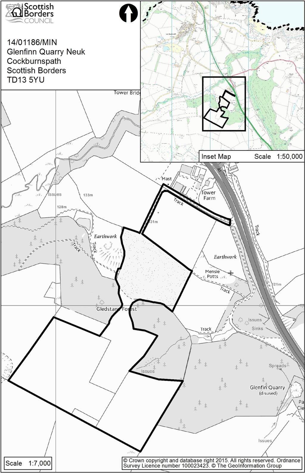
1 SCOTTISH BORDERS COUNCIL PLANNING AND BUILDING STANDARDS COMMITTEE 11 th JANUARY 2016 APPLICATION FOR PLANNING PERMISSION ITEM: OFFICER: WARD: PROPOSAL: SITE: APPLICANT: AGENT: REFERENCE NUMBER: 14/01186/MIN Mr Scott Shearer East Berwickshire Extension to quarry and associated works Glenfin Quarry Neuk Cockburnspath Mr Arnot Findlay (Kinegar Quarries Ltd) AMS Associates Ltd SITE DESCRIPTION The application site is located at Glenfin Quarry, an existing hard rock quarry located 2.5km to the south east of Cockburspath. The site occupies the north eastern side of Ewieside Hill which forms part of the skyline from areas around Cockburnspath. The A1 lies immediately to the east of the site and is connected to the quarry by a short access road. The existing quarry extends up Ewieside Hill in a south westerly direction through an existing mature planting belt. The whole quarry will cover 34.3ha with the proposed quarry extension covering 12.3ha of the total area. Plant and processing takes place in the northern end of the site, adjacent to the site access. An existing permission for the quarry allows the applicants to continue to quarry towards a dry stone boundary wall to the south west. The sites of the proposed quarry extension comprise of two agricultural fields tucked behind the mature woodland to the north west and south east of the presently quarried area. The site lies in-between the Berwick Coast Special Landscape Area (SLA) and the Lammermuir Hill SLA however it does not fall within either of these designations. Ewieside Hill, fort which is a Scheduled Monument lies immediately to the western corner of the site. The site is not subject of any nature designations. PROPOSED DEVELOPMENT There are three distinct aspect to the proposals contained in the application: 1. Quarry Extension: The existing quarry extends in a south westerly direction away from the A1. It is proposed to extend the working area of the existing quarry by extracting rock from areas to the north west (described as Area A) and south east (described as Area B) of the existing quarried area. The proposals are described in detail in the Planning and Supporting Statement and the submitted plans. Area A consists of the first seven phases and is to be quarried to a floor depth of 184m AOD. The extent of Area A has been reduced through the course of the application. Area B will undertake the last five phases to a bench level of 180m AOD. The expected working life is stated as being 30years. The stone is to be extracted using an excavator/loading shovel and crushed at the rock face by 1
2 the primary crusher. The crushed stone will then be transported to existing conveyed tunnel system where the material is screened and feeds the secondary crusher and final screening process. In the later stages (Phase 9-13) stone will be initially quarried using a tracked excavator before being delivered to the primary crusher and then fed through the onsite crushing and screening plant. All finished product will be stockpiled in the northern area of the site for off site sales. It is expected that on average 100,000 tones of stone per annum will be extracted. At present no blasting takes places at the quarry and the proposals do not include details on this means of extraction. 2. Landscaping and Bunding: Bunds/Mitigation Screen Mounds are to be formed around the western boundary of Area A, the south western boundary of the existing consent and the southern corner of Area B. The bunds are to have a maximum height of 4m and have been amended so that there are only shown to be primarily covered in grass instead of tree and scrub planting. 3. Restoration Plans: The restoration plans have been revised through the course of the application. The proposals seek to restore the whole of Glenfin Quarry. The proposals seek to reinstate the hill side and form two new wetland areas on lower lying ground. The submission proposes to undertake the restoration of the majority of Area A during the initial extraction phases of Area B. Final restoration and aftercare would continue for 18 month following the completion of stone extraction. PLANNING HISTORY Kinegar Quarries Ltd have been operating for over 26 years. The following planni9ng history is listed on our records; 13/00289/PAN Proposal of Application Notice for the proposed extension to the existing quarry. 03/01506/MIN Continuation of mineral workings Consent was granted for a 20 year period from the date of the consent ( ) subject to 38 planning conditions 99/00252/MIN - Use of land for the storage and reprocessing of inert material Approved /01274/MIN - Continuation and extension of existing quarry Withdrawn /00159/FUL - Temporary stockpiling of excavated materials from A1 road widening works Approved PUBLICITY AND REPRESENTATION SUMMARY Neighbour notification was carried out with all 5 properties within 20m of the site notified of the development. The application was publicised by the positing of site notices, and advertised under Environmental Impact Regulations. The application was advertised in the Berwickshire News and the Edinburgh Gazette and copies of the submission were provided to local contact centres. 2
3 A single comment was received from one of the neighbours in the residential property at Tower Farm to the north east of the site who also operate two holiday lets at this location. This general comment neither objected nor supported the application. The principal comments made can be summarised as follows; Increased traffic Noise nuisance Overlooking Privacy of neighbouring property including contributors holiday lets affected Additional planting should be required to screen the development Nuisance from the development results in loss of booking for their holiday lets A comment of support has been received from the Aggregate Industries who are a UK wide supplier of construction materials. They recommend that Glenfin Quarry supply a high standard of stone which there is otherwise a shortage of to meet the demands of the Governments increased investments in road network improvement in Scotland and England. Aggregate Industries have intimated that they are interested in entering an agreement with the applicant for the supply of their quarried stone. APPLICANTS SUPPORTING INFORMATION In addition to the plans and sections accompanying the submission, the following is relevant to this application: EIA requirements The development falls with Schedule 2 of the Environmental Impact Assessment Regulations (Scotland) As such the application was subject to screening, during which the Council identified that an Environmental Impact Assessment was required. The applicant requested a scoping opinion under Regulation 10 of the Environmental Assessment (Scotland) Regulations The council responded in June 2011 with its Scoping Response. The applicant has submitted an Environmental Statement (Volume 3 of the submission, with appendices in Volume 4) and a Non Technical Summary (Volume 1). Major Development Requirements As a major application there was a requirement for the applicant to undertake a Pre-Application Notification including community engagement. This was undertaken, and summarised in a Community Engagement Report submitted with the application. Other information and submissions The application has been accompanied by: Revised visualisations Revised restoration proposals 3
4 Drainage Details Archaeological Assessment of Effects upon Ewieside Hill, fort by CFA Archaeology Ltd Ecology surveys by BSG ecology Noise Assessments Dust Management Details CONSULTATION RESPONSES: Scottish Borders Council Consultees Access Ranger: The development may have a significant visual effect on an existing public pathway known as the BB8. A note is on file which confirms that this path was diverted through forestry as a result of the quarry operation. A condition is recommended that this route should be temporality or permanently diverted within the agreement of the Planning Authority. Archaeology Officer: 1 st Response 10 th December Recommend refusal. The proximity and size of the current proposal would dramatically and permanently destroy the topographic relationship of the setting of the Scheduled site of Ewieside Hill, fort to a degree that understanding and appreciation of why the form was located in this commanding ridge line location would be heavily degraded. The Environmental Statement (ES) fails to address the impact that the development would have on the setting of the fort. Over time the quarry will be seen as an historic/agricultural feature in its own right and its size will introduce a large industrial scale development which will interrupt the relationship between the fort and Ewieside Hill s eastern ridgeline which is out of keeping with its agrarian setting. In addition, there is a cumulative impact with the fort s setting in conjunction with the large wind energy developments in this part of Berwickshire. The quarry would add to a sense of industrialisation of the wider landscape for as much as a generation until the wind farms are decommissioned. The mitigation proposals are poorly designed appearing as an industrial bund which is not appropriate for the setting of the fort. To mitigate setting impact it was recommended that the footprint of the quarry would need to be reduced and designed with a more sensitive relationship to the fort. If approved, a development contribution towards an archaeological landscape study of North Berwickshire was recommended to provide a form of mitigation to compensate for the detrimental impacts caused by the scheme. In terms of direct impacts, should the application be approved ground evaluations in the form of a geophysical survey should be carried out before the development commences and there will be a need for post excavation research of any archaeological findings. It noted that the proposals include the siting of a post and wire fence over the Scheduled Monument area which is not acceptable. 2 nd Consultation Response 23 rd October 2015 Confirms that the proposed amendments dated the 14 th of October address the reasons of originally objecting provided that full restoration is secured and the amenity bank is completed prior to extension into the western field. The requirement for archaeological evaluation as part of an approved written scheme of investigation still stands. 4
5 Environmental Health: Based on the information provided which has included updated acoustic reports specific to the revised design of the amenity bund, the application is supported subject to conditions to control the following amenity implications; Restriction of quarrying operations and associated vehicle movements to specific times across a seven day working week. Limitation of noise levels and requirement for noise assessments by an independent consultation in the event of justified noise complaint. A dust management plan and on-going monitoring of dust levels including the need for a daily assessment to be carried out by the operator with a requirement for additional assessments during periods of strong winds and warm dry weather. Ecology: Satisfied that the Ecological Impact Assessment has been carried out properly. The extension of the quarry will result in the loss of improved pasture and area of gorse shrub. It is however unlikely that there will be any signification impacts on ecological interests provided conditions to require; No site clearance or habitats are disturbed during the breeding bird season (March-August) with the express permission of the Planning Authority. Supplementary badger surveys to inform construction activities are required before works commence. A badger development licence is to be obtained by the developer or confirmation from SNH that such a licence is not required. A Species Mitigation and Management Plan which includes measures for bats, otter, badger and breeding birds is agreed. A Landscape and Habitat Restoration Plan is agreed which includings measures for woodland habitat creation standing open water and wet land creation, species rich grassland and measures for bats, breeding birds and reptiles Flood Prevention Officer: The middle of the site is shown to have a small risk of pluvial flooding, nevertheless any flood risk is unlikely to have a significant effect on the capacity of the flood plain or affect local flooding problems. The development is not opposed on flood grounds. Landscape Architect: No objection. The skyline location of the development is potentially visually sensitive. The landform around the quarry will provide screening for the quarry void so the magnitude of change posed by the development in the landscape is quite small. There are a couple of exceptions to this where the change will be greater, from Tower Bridge on the A1 and Ewieside Hill. However, in wider visual terms, the impacts of the development do not warrant objection since the impact from Tower Bridge is largely due to the impact of the existing consented works and the effects on Ewieside Hill, Fort can be mitigated. The proposed Indicative Restoration Plans illustrates the infilling of the quarry void to variable grades should blend with the natural landform with the man made valley resembling a natural gully occupied by two water bodies. No objection is raised to the restoration strategy, however the ability to deliver the proposed restoration is queried. The restoration strategy appears to rely on a separate material import operation which can not start until the western void is fully excavated with the whole of the restoration taking place in the latter phases. Clarification on the volume of imported material should be sought and it is recommended that a condition is used to require restoration before the later phases are commenced. Further details are required regarding the intended planting and seeding associated with the restoration work. 5
6 Roads Planning Officer: The site is accessed directly from the A1 trunk road therefore the observations of Transport Scotland should be sought on the implications that the quarry extension will have on vehicle movements. Statutory Consultees Association for the Protection of Rural Scotland: No response received. Community Council: No objection however the following points are raised; The impact of the development upon Ewieside Hill rises concern however the CC are willing to follow advice from statutory consultees. Mitigation measures will be required to ensure that impact on residential amenity of the local community is mitigated, particularly in relation to dust, noise and screening. Assurances must be made that planning condition will be rigorously complied with. Historic Scotland (HS): 1 st Consultation Response 28 th November 2014 Identify that Ewieside Hill, fort 640m NE of Edmondsdean (Scheduled Monument index No. 369) is located adjacent to the developments site boundary. In their 1 st response HS objected to the proposed quarry extension for its potential significant adverse impact on the setting of the Ewieside Hill, fort. The monument is viewed to be an exceptional field monument dating thought to date from the Iron Age with wellpreserved upstanding remains. It is an enclosed settlement consisting of three concentric ramparts and ditches with the remains of at least two ring-ditch houses. The setting is characterised by its immediate location on a hill at the end of a high ridge with commanding views to the east, south and north and contributes towards a better understanding of forts and defended settlements in the eastern Borders. Concerns were raised by HS in their first two consultation responses that the removal of a large quarry section close to the monument would have a significant adverse impact on its topographical setting. The Heritage Chapter in the Environmental Statement is not viewed to provide a valued judgement on the proposed bund/woodland planting mitigation strategy. 2 nd Consultation Response 17 th March 2015 In response to the additional information provided about the formation of a 4m high amenity bank as a means of mitigation, HS were concerned that this bund would add a new feature in the landscape which may itself impact on the setting of the monument and fail to retain enough of the hillside to reduce its impact to an acceptable level. It was recommended that the best mitigation strategy could be achieved through greater retention of the hillside with a reduced quarry extension. 3 rd Consultation Response 3 rd July 2015 On receipt of a new archaeological assessment, details of a re-profiled and extended amenity bank and restoration plans, HS recommended that the proposed restoration strategy was welcomed. The relevance of the amenity bank was questioned. It was recommended that instead of the linear eastern cut of the quarry a cut which follows the contours with the bank would better retain an understanding of the open hillside during the works. 4 th Consultation Response 28 th October 2015 Confirm that the amended plans dated 14 th October address previous concerns about the developments impact on Ewieside Hill and enable the original objection to be withdrawn. This recommendation is on the assumption that full restoration is 6
7 secured that the end of the working quarry through either a planning condition or legal agreement. Health and Safety Executive: Online system confirmed that surface mineral workings are subject to the provisions of the Health and Safety at Work etc Act 1974 and the Quarries Regulations Enforcement is by the Quarry Inspectors of the Health and Safety Executive, who have knowledge and expertise regarding geotechnical considerations. Under the Quarries Regulations, it is the responsibility of the operator to ensure that excavations are designed, constructed, operated and maintained in an appropriate manner to avoid stability or movement issues which are likely to give rise to health and safety risks is avoided. NERL Safeguarding: No safeguarding objections are raised. Royal Society for Protection of Birds (Scotland): No response received. Scottish Environmental Protection Agency (SEPA): Initially objected on grounds of lack of information relating to site drainage and impact on the ground water environment. SEPA confirmed in a second consultation response dated the 26 th of February 2015 that additional information and calculations had been received which addresses their original concerns. The additional information confirmed that the two existing lagoons would not have sufficient capacity to handle surface water from the extended site and these lagoons would require to be extended with an additional two new lagoons constructed. SEPA are content that once the extended water treatment system is in place that there will be sufficient capacity to treat the surface water arising at the site and these works are to be secured by a planning condition. Additional information confirms that there are no private water supplies (PWS) in the vicinity of the development which will be affected by the development and the initial objection on lack of information about impact on the ground water environment has been withdrawn. It is noted that no dewatering is assumed to be required to control ground water within the quarry but should a volume greater than 10m3/day be extracted then a Controlled Activities Regulations (CAR) licence will be required. SEPA are satisfied with the extractive waste management plan proposals and have confirmed that the quarrying activity is unlikely to result in adverse level of air quality pollution at the nearest sensitive receptors. Scottish Natural Heritage: No response received. Scotways: Identify that the right of way ref; BB8 to the north of the site is affect the development and its exact alignment may have changed, however Scotways have no record of official diversion. It is recommended that a right of way from Stockbridge to the A1 loop remains open and free from obstruction before during and after the operation of the quarry. It is recommended that the access route should be upgraded through the quarry restoration proposals to help mitigate some of the negative impacts on recreational activity. Scottish Badgers: No objection. Recommend that the applicant should undertake a standing site order for all holes to be checked to prevent injury to badgers crossing the site. Scottish Water: No response received. 7
8 Scottish Wildlife Trust: No response received. Transport Scotland: No objection. It should be noted that any works to be carried out within the boundary of the trunk road require the permission from Transport Scotland. Other Consultees Berwickshire Civic Society: No response received. DEVELOPMENT PLAN POLICIES: SES Plan Strategic Development Plan 2013 Policy 4 - Minerals Consolidated Scottish Borders Local Plan 2011 Principle 1 Sustainability Policy G1 Policy D1 Policy H2 Policy NE4 Policy BE2 Policy NE3 Policy NE5 Policy EP5 Policy ED2 Policy EP2 Policy Inf2 Policy Inf4 Policy Inf5 Policy Inf6 Policy R3 Quality Standards for New Development Business Tourism and Leisure Development in the Countryside Protection of Residential Amenity Trees, Woodlands and Hedgerows Archaeological Sites and Ancient Monuments Local Biodiversity Development Affecting the Water Environment Air Quality Employment Uses Outwith Employment Land Areas of Great Landscape Value Protection of Access Routes Parking Provisions and Standards Waste Water Treatment Standards Sustainable Urban Drainage Mineral and Coal Extraction OTHER PLANNING CONSIDERATIONS: Proposed Local Development Plan (PLDP) 2013 PMD1 PMD2 ED2 ED7 ED12 HD3 EP3 EP5 EP8 IS5 IS7 IS9 Sustainability Quality Standards Employment Uses Outwith Business and Industrial Land Business, Tourism and Leisure Development in the Countryside Mineral and Coal Extraction Protection of Residential Amenity Local Biodiversity Special Landscape Areas Archaeology Protection of Access Routes Parking Provisions and Standards Waste Water Treatment and Sustainable Urban Drainage 8
9 Scottish Borders Council Supplementary Planning Guidance: Local Biodiversity Action Plan (2001) Biodiversity (2005) Landscape and Development (2008) Scottish Government: NPF3 National Planning Framework 2014 SPP Scottish Planning Policy 2014 PAN 1/2013 Environmental Impact Assessment PAN 2/2011 Planning and Archaeology PAN 1/2011 Planning and Noise PAN 75 Planning for Transport (2005) PAN 73 Rural Diversification (2005) PAN 64 Reclamation of Surface Mineral Workings (2002) PAN 60 Planning for Natural Heritage (2000) PAN 56 Planning for Noise (1999) PAN 51 Planning and Environmental Protection (Revised 2006) PAN 50 Controlling the Environmental Effects of Surface Mineral Workings (1996) PAN 50 Annexe A D (Control of Noise, Dust, Traffic and Blasting at Surface Mineral Workings) (1996) Circular 4.98 Use of Conditions KEY PLANNING ISSUES: The main determining planning issues relevant to the consideration of this application are; Whether the proposed extension of an existing minerals quarry would comply with development plan polices related to minerals development and is environmentally and socially acceptable. Whether the development would adversely affect the setting of cultural heritage assets, in particular Ewieside Hill, fort Scheduled Monument. Whether the development would have an adverse visual impact which would detract from the landscape. ASSESSMENT OF APPLICATION: Policy Principle The Scottish Governments strategy for long term spatial development, the National Planning Framework (NPF3) and the government s policy on nationally important land use planning matters, Scottish Planning Policy (SPP) both identify that minerals development make an important contribution to the economy by providing construction materials. The Strategic Development Plan for the Scottish Borders recognises that the plan area needs to ensure that a steady supply of minerals is available to support sustainable economic growth. Policy R3 of the Consolidated Local Plan 2011 aims to support mineral workings provided that development can be carried out with minimal adverse impact on the environment and with appropriate restoration measures following extraction. The Local Plan Policy sets out the 9
10 situations and circumstances in which minerals extraction will and will not be supported. The thrust of planning policy at national, regional and local level is to support the principle of mineral extraction because of its contribution towards supplying the need for raw materials, creating employment opportunities and generally contributing to economic growth, particularly in rural areas. However, this has to be balanced with the requirement to ensure that the impacts of the extraction of minerals have minimal adverse impacts on the environment, built and natural heritage and local communities. In locations where minerals extraction can be supported, planning decisions must seek to secure the sustainable restoration of sites to a beneficial after-use once working has ceased. When assessing the policy context of this application is it important to acknowledge that this proposal is seeking to extend an existing operational quarry. The quarry operations at Glenfin have been on-going for some time at least since the 1990s. The independent correspondence received from Aggregate Industries confirms that there is still a demand for stone produced from Glenfin Quarry, with its high standard of finish being suitable for road infrastructure projects in Scotland and England. The site remains to benefit from good strategic transport links owing to its location directly adjacent to the A1 so that it is well placed to supply its product demand to the north and south. It is therefore clear that there is still a demand and marketplace for aggregate materials from this quarry. The supporting statement and submitted plans recommends that the phased extraction from the extended quarried areas would take 30 years. Importantly the average volume of extraction of 100,000 per annum would remain consistent with the rate of extraction from the existing quarry. The continued working of the site would retain 10 jobs directly employed with the operations at Glenfin Quarry and indirectly provide employment for up to 15 people mainly through the haulage sector. This proposal will help to maintain employment opportunities in this rural area. The proposed restoration plans which cover the whole of Glenfin Quarry confirm that these extensions represent the final extraction phases for this quarry and when they are complete the minerals operation at Glenfin will cease and the land will be restored. Despite the backdrop of an economic downturn, there remains a continued demand for extractive material to assist to realise infrastructure investment plans which this development is understood to directly contribute to and meet housing needs. The principle of the proposal is not considered to represent a departure from planning policies. The development will allow the Scottish Borders to maintain a steady supply of aggregate as required by national polices by allowing the continued operation of an existing, well established hard rock quarry which is logical. While this proposal does extend the working area it does not intensify the average rate of extraction from the site and conditions imposed on the previous consent to control extraction can be re-applied to limit the average material extraction across a suitable time period. In accordance with accepted practice, it is recommended that any permission granted would be temporary. The appropriate restoration of this site will be imperative, especially as this application is expected to represent the final extraction at Glenfin Quarry. In SPP the Scottish Government advocates that through legal agreements and conditions, planning authorities should ensure that a high standard of restoration and aftercare is secured by considering the most effective solution on a site-by-site basis. In this particular case, the quarried site is large and affects an important location for 10
11 landscape and archaeological reasons. To ensure that adequate assurances are in place that the site will be restored properly, it is recommended that a Section 75 legal agreement should be entered into to agree the delivery of restoration proposals and for a financial restoration bond as a guarantee. The use of a legal agreement will provide sufficient assurances that the acceptable restoration work will be undertaken and the applicant has agreed to enter into a S75 agreement on this basis. In principle, the proposed development is considered acceptable and is consistent with the qualifying criteria for appropriate mineral extraction contained within Consolidated Local Policy R3. This is of course subject to further detailed consideration of relevant environmental and other impacts which are covered below. This policy position is unaltered by the emerging Local Development Plan. Landscape and Visual Impacts Glenfin Quarry lies in-between two Landscape Character Areas with the ground of the proposed extensions being located within the elevated Platform Farmland which is part of the Eye Water Landscape Character Area. The submission has been accompanied by Zone of Theoretical Mapping (ZTV) with a selection of viewpoints identified. The final version of details includes updated visualisations to illustrate the revised amenity bunds and plans to show the reduced working area of the quarry. The proposed restoration proposals were updated through the course of the application and are accompanied by an updated Restoration Statement. The proposed extension sites are presently used for grazing. The extensions are to take place on Ewieside Hill which forms part of the southern skyline around Cockburnspath. The extensions flank a consented working area which has permission to extract rock from Ewieside Hill. Potentially, the main public visual impacts from this quarry are from the east and north, most notably from the passing A1 where the existing operation can be seen to extend through Gledstone Forrest where it forms a notch on the hill. There is potential for visibility from viewpoints 4, 5 and 6 however the extended areas will largely be tucked behind the woodland planting which will screen the majority of the new proposed working areas from these public sides with the existing quarry operation remaining visible in the foreground. From the majority of the other viewpoints outwith the 1km radius, the retained landform around the quarry void along with the amenity bunds which are to be formed around the outer edges of the extended areas will help to screen the development. The amenity bunds have been altered so they are to be finished with a grass covering which more appropriately integrates with the surrounding ground cover so they will appear more natural features in the landscape. The amenity bunds are to be formed from the top soil removed from the areas of the proposed extension. Precise details of all the bunds is lack however an appropriately worded planning condition can seek to agree their details and ensure that the bunds are complete before extraction commences on each particular area. Overall the proposed extensions to Glenfin Quarry result in a small magnitude of change against the impact of the existing quarry within the landscape. The proposals are not considered to pose any detrimental effects upon the setting of either the Lammermuir Hills or Berwickshire Coast Special Landscape Areas which the 11
12 development sits in-between. The Council s Landscape Architect has advised that in visual terms, the landscape impacts of these proposals do not warrant objection. A critical consideration for this development is to ensure that the site will be restored properly. The revised restoration plans illustrated on Drawing No 8020 C1 indicate that incline towards the summit of Ewieside Hill will be restored in a manner that reflects the original landform. A valley is to be left which is to be occupied by two water bodies to connect the existing notch through the forest and the site compound; this feature should reassemble a natural gully. The updated restoration proposals satisfy the Council Landscape Architect and are judged to represent appropriate restoration in a manner sensitive to the landscape character of the surrounding area. When extraction is complete from Area A, this part of the site is to be restored when the extraction process moves to Area B, see Drawing No 8013 C1. The continuous restoration of part of the site which is exhausted from extraction while another part of the site is worked is welcomed because it will limit the intrusion of the development in the landscape. Concerns about the ability of the applicant to deliver the restoration strategy have been raised however by entering into a Section 75 Legal Agreement to secure a bond for the restoration work; necessary contingency measures will be in place to provide assurances that the site will be restored appropriately. The proposals contained within the Restoration Statement (dated 20 th April 2015) contains a reasonable level of the detail of the restoration proposals however further details particular in relation to timings of the phased restoration proposals can be agreed through the Section 75 agreement and related planning conditions. Impact on Cultural Heritage Archaeology The application site is located immediately adjacent to the east of Ewieside Hill, fort Scheduled Ancient Monument (SAM). Historic Scotland have advised that the monument is viewed to be an exceptional field monument which dates from the Iron Age and consists of well-preserved upstanding remains which is of national significance. The setting is characterised by its immediate location on a hill at the end of a high ridge with commanding views to the east, south and north. Its positioning contributes towards a better understanding of the location of forts and defended settlements in the eastern Borders. Policy BE2 of the Consolidated Local Plan aims to give Scheduled Ancient Monuments strong protection from developments which would adversely affect their appearance, fabric or setting. This may result in the need for in-situ preservation or further evaluation to identify appropriate measures of mitigation. Indirect Impacts Historic Scotland (HS) and the Council s Archaeologist both raised significant concerns in response to the impact the original proposals were considered to have upon the setting of Ewieside Hill, fort. In particular the proximity and scale of the quarry extension contained within Area A of these proposals were viewed to introduce a large scale industrial feature which would be out of keeping with the agrarian setting of the fort. The understanding of the location of the fort upon its commanding ridgeline location was judged to be heavily degraded by these proposals. The proposed mitigation was viewed to be industrial scale bunding of stripped top-soil with scrub planting which was not appropriately designed to protect the setting of the fort. Issues were also raised that the proposals would contribute to 12
13 the cumulative industrialisation of the surrounding landscape in association with neighbouring wind development approvals. Through the course of the application revised proposals have been submitted to address the concerns of the impact that the development would have upon the setting of the Scheduled Ancient Monument (SAM) and a meeting was held with the agent which HS and our Archaeologist attended. The revisions detailed within the plans received on the 14 th of October 2015 (which have remained unchanged in the recent upgrades of the 23 rd of November 2015) have been viewed positively by HS and our Archaeologist to an extent where both consultees have lifted their original objections. The amended proposals have reduced the footprint of the quarry extension proposed as part of Area A so that the area of mineral extraction is further removed from the SAM. As a result of the reduction in scale of the proposal, the westerly extension is further removed from the ridge of the hillside which minimises its intrusion upon the setting of the SAM. Space is created for a re-profiled wider amenity bund to separate the extension from the SAM which will no longer be planted with trees and scrub and instead consist of a grass finish. The outer edge of the quarried part of Area A has been altered so that it that it broadly follows the contour of the hillside allowing for a more natural edge instead of the linear termination illustrated in the original proposals. The proposed revisions to the western extension of Glenfin Quarry are considered to produce a less invasive form of development which reduces the impact of proposals upon the setting of Ewieside Hill, fort to a tolerable level. In addition the reduced scale of the development is no longer perceived to detrimentally contribute to the industrialisation of the surrounding area in accumulation with surrounding wind farm developments. Within a latter response from HS the relevance of the amenity bunds were questioned however following the revisions to the bunds within the final amendment HS have not raised any concerns about their inclusion as part of the scheme. The revised design of the western amenity bund is judged to be more sympathetic to the setting of the hill fort. To ensure that the bund provides adequate mitigation it will need to be complete before mineral extraction commences within Area A, this requirement can be secured through an appropriately worded planning condition which will allow the formation of the bund using topsoil from the area of extraction. The revised restoration proposals of the development site have been welcomed by HS and our Archaeologist. Securing the suitable restoration of the site through suitably worded planning conditions and a legal agreement will ensure that the development will not leave any detrimental long lasting effects upon the setting of SAM. It should also be noted that the early restoration of Area A will assist limit the lifespan of the effects which the development will have upon Ewieside Hill, fort. The recommendation from the Archaeology Officer within his original response for a development contribution towards an archaeological landscape study of North Berwickshire was recommended to provide a form of mitigation to compensate for the detrimental impacts caused by the original scheme. Given that the application has been revised to a standard which addresses the objection from the Council s Archaeologist, it would be inappropriate to pursue such a developer contribution. Direct Impacts The ES identifies that mitigation of direct impacts will require further evaluation. The Councils Archaeologist recommends that evaluation should consist of a high resolution geophysical survey of the entire quarry area followed by evaluation 13
14 trenching. The identification of significant buried archaeology in areas where there will be direct impacts, or indirect impacts through vibrations, will likely require further excavation, post-excavation research and publication. In accordance with Policy BE2, suitably worded planning conditions can seek for further evaluation to identify appropriate mitigation. It noted that the proposals include the siting of a post and wire fence over the Scheduled Monument area which is not acceptable and would require the applicant to obtain Scheduled Monument Consent from HS. The removal and repositioning of this fencing can be agreed by way of a planning condition. In the absence of any remaining concerns from HS and the Councils Archaeologist, it is recommended that subject to the compliance with planning conditions and the conclusion of a legal agreement that the development is not considered to destroy or adversely affect the setting of the Scheduled Monument and meets the requirements of Policy BE2. There are no Listed Buildings, Conservation Areas or gardens and Designed Landscape which will be affected by this development. Impact on Residential Amenity A single general comment has been received from a local resident. Although raising no objection in principle, concerns were raised that the development would increase levels of noise and dust and also detract from the visual amenity of their dwellinghouse and two holiday lets at Tower Farm. All these issues have the potential to have an adverse impact on residential properties. It should however be noted that the existing quarry has planning permission, and has obtained other approvals and permits necessary to operate which are regulated by SEPA and the HSE. Further details on this regulation are set out in the ES and the Supporting Statement. The proposed extensions will not bring operations any closer to the closest third party properties to this site which are those of Tower Farm. It is accepted that the development will prolong the lifetime of the minerals operation at Glenfin; however, the quarry working would not be carried out in any more intensive a manner than the existing operations. Amenity bunds are to be formed around the edge of the extended areas which are designed to the satisfaction of the Environmental Health Officer (EHO) to reduce the impact of the development upon neighbouring properties. SEPA have confirmed that the quarrying activity carried out as part of the extractive waste management proposals is unlikely to result in adverse level of air quality pollution at the nearest sensitive receptors. Subject to the imposition of planning conditions to regulate matters such as the suitable noise levels, dust management, prevention of mud, and other material being carried outwith the site in the interest of road safety the EHO has advised that the development can be supported. The imposition of these mitigation measures will account for the safeguards for residential amenity of surrounding residential properties which are sought from the Community Council. The suggestion by the contributor for a planting belt to be formed between the site and Tower Farm as mitigation from dust and noise nuisance is not necessary as a result of the respective recommendations regarding noise and dust control from the EHO and SEPA. The development is not considered to result in caused any new adverse visual impacts upon the amenity of any of the surrounding residential properties. 14
15 Subject to the noted schedule of conditions, the proposed development is considered acceptable in terms of impact on residential amenity, and to comply with Policies G1 and H2 of the Consolidated Local Plan. Impact on Natural Heritage The development does not impact upon any natural heritage interests of national importance. The nature conservation site is the SSSI at Pease Bay Glen which is separated from the development by the A1 and the East Coast Railway line. The proposed development will not get any closer to the designated site than the distance of the existing operation. SNH have not raised any objections to these proposals. The Council s Ecologist confirms that the extension of the quarry will result in the loss of improved pasture and area of gorse shrub. Provided that planning conditions are adopted, sufficient means of mitigation will be in place to avoid a significant adverse impact upon any ecological interest. Recommended conditions should seek to; control site clearance, require checking surveys for badgers, agree a species mitigation plan (which should include protective measures for bats, otter, badger and breeding birds) and incorporate biodiversity enhancement into the restoration of the site through a landscape and habitat restoration plan. Subject to mitigation and any required checking surveys the proposed development will not have an adverse impact on ecology and wildlife of the area and can be considered compliant with Policy NE3 (Local Biodiversity). Drainage, Dewatering and Hydrology SEPA initially raised concerns about the lack of information submitted to determine if suitable measures were in place to handle site drainage from the development and whether any ground water extract is required. The agent prepared a drainage strategy which included full runoff design calculations in their documents and plans submitted on 27 th January The additional details confirm that the existing two lagoons which serve the surface water run-off from the existing consented areas do not have sufficient capacity to handle run-off from the extended areas. It is proposed to extend the existing lagoon and alongside it construct two additional lagoons, as shown on Fig 2, Fig 3 and Fig 4 of the Drainage Detailed Plans. The new lagoons will be constructed at the north east of the site and connect to the existing site drainage system which consists of a collection pond and sump. Water from the extended quarried areas will be channelled to the drainage system via internal drains. In an updated consultation response, SEPA have confirmed that the proposed upgraded water treatment system would provide sufficient capacity to handle run-off from proposed quarry extension. The submission of additional information by the agent has confirmed that the development will not require any dewatering operations to control groundwater within the quarry or impact on impact on any private water supplies within the vicinity of the development. This has enabled SEPA to withdraw concerns the original they expressed upon these aspects of the development. SEPA do advise that should a volume of water greater than 10m 3 /day be extracted then a Controlled Activities Regulations (CAR) licence will be required. The proposal would not affect any water courses and subject a suitably worded planning condition to seek for the completion of the upgraded drainage system and 15
16 an informative note in relation to CAR requirements, the proposed development is considered to comply with Consolidated Local Plan Policy NE5 (Development Affecting the Water Environment). Impact on Road Safety The location of the development a short distance from the A1 which means that vehicles can readily access the trunk road network without having to use an extensive length of minor roads. Increased traffic has been raised as a ground of objection. The development proposes to extract minerals at the same rate as the existing quarry operation, consequently the development should not result in an increase volume of traffic over and above existing levels. Objection on grounds of increased traffic is therefore not considered sustainable given the context of the existing development. Transport Scotland and the Roads Planning Officer were both consulted on this application and have not raised any objection to this proposal nor have there been any request of any upgrades to the existing road network. Rights of Way Scotways and the Council s Access Ranger have identified that a right of way, reference BB8 which connects Stockbridge to the west and the A1 loop road to the east dissects the present working area of the site. The Agent has suggested that because the site is an operational quarry normal access rights do not apply under Land Reform legislation and that the path was re-routed to the north to avoid the operational quarry. Neither the applicant nor Scotways have any formal record of the agreed diversion on this route, however the Access Ranger has a file note which suggests that the path was re-routed through a forest however this does not appear to correlate with the existing diversion. There does appear to be a lack of clarity across the previous diversion of route BB8. Therefore if members are minded to approve this application, it is recommended that a planning condition is used to seek formal agreement of the diversion of this route. This will enable the applicants, Scotways and the Council s records to be properly updated. The restoration plans allow for the original route to be re-established once the quarry operations cease. From a visual perspective, it is not considered that these proposals will pose additional adverse landscape affect from route BB8 against those already faced by the existing development. Hours of Operation It is proposed to amend the hours of operation on the site. The existing hours of operations and traffic movements consented in the 2004 planning approval are: Mondays to Fridays Saturdays It is proposed in this application that the hours of operation would be altered so the operations at the quarry which include; soil stripping, mineral extraction and processing and transportation would be altered to the following working hours: Mondays to Fridays Saturdays 16
17 The Environmental Health Officer has suggested extension of the existing consented hours would be inappropriate in their consultation reply. In particular the increased working hours would increase the impact of the development upon the neighbouring properties. In light of this, it is understood that the existing working hours are based on best practice measures so it is considered that re-imposing the existing established working hours would be appropriate in this case. CONCLUSION The quarry has been established for over 20 years and has supplied a mineral resource which has benefited the economy and provided job opportunities within the rural area. It is acknowledged that the proposed extensions are large and the extraction operation is intensive however the application has demonstrated that there is still a market demand for rock extracted from Glenfin Quarry. The reduced scale and amended design of the proposed quarry extensions coupled with revised amenity bund protection has overcome archaeological issues so that the proposed development is no longer viewed to adversely affect the setting of Ewieside Hill, fort Scheduled Monument. It is therefore considered that the proposals comply with national and local policies in relation to mineral workings and that subject to a legal agreement to ensure that the final restoration is undertaken (through a restoration bond or similar) and conditions, mitigation plans and careful monitoring at all stages, that the development will not have a significant adverse impact on archaeology, ecology, landscape setting, surface water drainage or the amenity of neighbouring properties. RECOMMENDATION BY CHIEF PLANNING OFFICER: I recommend the application is approved subject to a legal agreement to the provision of a bond to secure the restoration of the site and subject to the following planning conditions: 1. The development hereby permitted shall be carried out in strict accordance with the approved scheme of working detailed in the plans and specifications approved by the Local Planning Authority. No extraction shall take place below the maximum floor depth shown on the approved plans, and in any event, no lower than 184 metres Above Ordnance Datum within Area A (Phases 1-7) and 190 metres Above Ordnance Datum within Area B (Phases 8-13). Reason: To ensure that the development is carried out in accordance with the approved details. 2. A site notice or sign shall be displayed in a prominent place at or in the vicinity of the site until the completion of the development, which shall be readily visible to the public, and printed on durable material. The Notice shall take the following form: Development at (Note 1) Notice is hereby given that planning permission has been granted, subject to conditions (Note 2) to (Note 3) on (Note 4) by Scottish Borders Council. The development comprises (Note 5) 17
18 Further information regarding the planning permission, including the conditions, if any, on which it has been granted can be obtained, at all reasonable hours at Scottish Borders Council 1Headquarters, Newtown St. Boswells, Melrose. Telephone (01835) , or by visiting using the application reference (Note 6). Reason: To ensure compliance with Section 27C of the Town and Country Planning (Scotland) Act 1997, as amended by the Planning etc. (Scotland) Act Planning permission is granted for a period of 30 years from the date of the commencement of the development. Unless an application is made and granted for its continuation or extension, the working of the quarry and all ancillary operations shall be discontinued within 30 years of the date of commencement of the development. Reason: To ensure satisfactory development of the site and to safeguard the amenity of the area. 4. The rate of mineral removed from the land shall not exceed 100,000 tonnes per annum over any period of 3 years. Written records shall be kept by the operator of all HGV movements off site including the weight of mineral carried by each vehicle and that information shall be made available for inspection by the Planning Authority on an annual basis on the last day of March each year. Reason: To safeguard the amenity of the surrounding area and avoid excessive extraction levels. 5. Notwithstanding the provisions of Part 16 of the Town and Country Planning (General Permitted Development) (Scotland) Order 1992, as amended, no buildings, plant or machinery, including that of a temporary nature, shall be erected, placed or installed without the prior consent of the Planning Authority. Reason: In order that the Planning Authority retains effective control of the development in the interests of amenity. 6. The hours of operations for all working, with the exception of measures required in an emergency situation, servicing, maintenance and testing of plant, shall be limited to the hours of 0700 hours to 1900 hours Mondays to Fridays and 0700 hours to 1300 hours on Saturdays and not at all on Sundays, unless with the prior agreement of the Planning Authority. In addition, no operations shall be permitted on 25 and 26 December and 1 and 2 January. Reason: To adequately protect the residential amenity of surrounding residential properties. 7. No development shall commence until the applicant and /or the operator of the quarry provide to the Planning Authority details of the bond or other financial provision which it proposes to put in place to cover all the decommissioning, site restoration and aftercare costs of the development. Thereafter: (a) No development shall commence on the site until the applicant and /or the operator of the quarry has provided documentary evidence that the proposed bond or other financial provision is in place and written confirmation has been given by the Planning Authority that the proposed bond or other financial provision is acceptable in all respects. 18
19 (b) The applicant and /or the operator of the quarry shall ensure that the approved bond or other financial provision is maintained throughout the duration of this consent. If at any stage of the operations a bond or other financial provision is not in place, all operations at the quarry shall cease. Operations shall only recommence once a replacement bond or other financial provision is accepted by the Planning Authority. (c) The bond or other financial provision will be subject to a five yearly review which shall include a monitoring statement of extracted and reinstated levels, paid for by the applicant and /or the operator of the quarry, from the Commencement of Development, to be conducted by a competent independent professional (Compliance Monitoring Officer) who has relevant experience within the quarrying sector and provided to the Company, the landowners (if different), and the Planning Authority. Reason: To ensure suitable provisions are made for restoration of the site, and to minimise the longer term visual impacts of the development. 8. No development shall commence until a detailed scheme for the restoration and the after care of the site to be submitted and approved by the Planning Authority. This will provide full details of final restoration contours, levels, gradients, volume of imported material and provide for satisfactory reinstatement of surface drainage. The scheme shall include details for the phased programme for the restoration of the site. Once the restoration and aftercare scheme has been agreed in writing with the Planning Authority, the development shall only commence in strict accordance with the agreed details unless any variation are agreed with the Planning Authority. Reason: To ensure the satisfactory restoration and aftercare of the site. 9. No landfill or waste shall be deposited on the site other than quarry waste arising from the site or soil forming material without the express written permission of the Planning Authority to deposit landfill or waste. Reason: To safeguard the amenity of the surrounding area. 10. No extraction or encroachment of machinery or deposit of equipment, spoil or other material to be permitted outwith the site boundaries. Reason: To protect the amenity of the surrounding area and ensure that development is operated within the limitations of its site. 11. No development shall commence until precise details of all amenity bunds have been submitted to and agreed in writing with the Planning Authority. Details to be submitted shall include levels, height, formation and vegetated finish. Once the details of the amenity bunds have been agreed no extraction shall commence within Area A or Area B until the amenity bunds illustrated on Drawing No s 8007C1, 8013C1 and Section Drawing Fig 2 have been completed in accordance with the approved details. Reason To protect the amenity of the surrounding area and the setting of Scheduled Ancient Monument prior to extractive work commences within the affected areas. 12. No development shall take place until the applicant has secured and implemented a programme of archaeological work in accordance with a Written Scheme of Investigation outlining a Desk Based Assessment, Geophysical Survey and Evaluation. The requirements of this are: The WSI shall be formulated and implemented by a contracted archaeological organisation working to the standards of the 19
20 Institute for Archaeologists (IfA) approval of which shall be in writing by the Planning Authority. The developer shall allow sufficient time in advance of development for all archaeological works to be conducted to the satisfaction and written approval of the Planning Authority. The developer shall allow the archaeologist(s) access to all areas where development is to be undertaken and where positive geophysical results are possible to conduct all survey and excavation work required. Results shall be submitted at least one month prior to development to the Planning Authority for review and agreement in writing in the form of a Desk-based Assessment, Geophysical Survey and Evaluation Report. In the event that the report highlights areas of archaeological potential these shall require further targeted evaluation prior to development. If significant archaeology is identified by the contracted archaeologists and in agreement with the Planning Authority, a further scheme of mitigation subject to an amended WSI shall be implemented prior to development. Significant archaeological finds will undergo appropriate postexcavation research and publication subject to a separate Post- Excavation Research Design Reason: The site is within an area where ground works may interfere with, or result in the destruction of, archaeological remains, and it is therefore desirable to afford a reasonable opportunity to record the history of the site. 13. In the event that significant archaeological features, finds or deposits are identified and deemed as such by the Council s Archaeology Officer, either during the course of archaeological investigation or development, the developer shall ensure that these are recovered by a by a contracted archaeological organisation working to the standards of the Institute for Archaeologists (IfA) approval of which shall be in writing by the Planning Authority and undergo a programme of post-excavation research in accordance with a Post-Excavation Research Design (PERD) approved in writing by the Planning Authority. The requirements of this are: The results of all post-excavation research and analyses will be submitted to the Planning Authority and disseminated appropriately through publication and community engagement within one year of the final on-site archaeological investigations and reporting. The applicant s archaeological contractor shall ensure that the full archive of materials and records be submitted to Treasure Trove and the National Monuments Record of Scotland within one year of the completion of post-excavation research and archived appropriately according to national guidelines. Reason: Development of the site has resulted in the recovery of significant archaeological materials that will add to regional or national knowledge, and it is therefore desirable to conduct appropriate work to preserve and disseminate the full archaeological record of the site s history. 14. No fencing or any other structures shall be erected within the site of Ewieside Hill, fort Scheduled Ancient Monument unless evidence is submitted to the Planning Authority to prove that the developer has obtained Scheduled Monument Consent for the works from Historic Environment Scotland acting 20
21 on behalf of the Scottish Ministers and thereafter the prior approval is given from the Planning Authority in consultation with the Councils Archaeologist for such works. Reason: The siting of post and wire fencing or any other means of enclosure within the site of the Scheduled Ancient Monument is inappropriate unless the statutory consent is given for such works. 15. During operation hours a free field equivalent continuous noise level (LAeq) 1hour 55db shall be applicable for all quarry operations excluding soil and overburden handling activities and other works in connection with landscaping at Glenfin Quarry Extension at any noise sensitive property existing at the time of this application. Reason: In the interests of neighbouring amenity at the nearest noise sensitive properties. 16. During operational hours a free field equivalent continuous noise level (LAeq) 1hour 70db shall be applicable to soil and overburden handling works in connection with landscaping at the nearest noise sensitive property and limited to a period not exceeding 8 weeks in one calendar year at any one property. Reason: In the interests of neighbouring amenity at the nearest noise sensitive properties. 17. At the request of the Planning Authority, following a complaint to Scottish Borders Council relating to noise from the site, the applicant shall at their own expense, employ an independent consultant, approved by the Planning Authority, to assess the level of noise from the site in line with PAN50. This report shall be provided to the Planning Authority within 3 months of the request. If the report demonstrates that the site is not in compliance with Condition 15 and 16 relating to noise all site activities will cease until the applicant has proposed a scheme of mitigation and this has been approved by the Planning Authority. Thereafter the development shall resume in strict accordance with the agreed scheme. Reason: In the interests of neighbouring amenity at the nearest noise sensitive properties. 18. No development shall commence until a scheme for monitoring of dust levels has been submitted to and agreed in writing with the Planning Authority. The scheme shall include the details and location of dust monitoring equipment which is to be positioned at locations around the site. Once approved the development shall commence in strict accordance within the agreed scheme and the operator and on request the operator shall furnish the Planning Authority with particulars of measurements recorded by the equipment. Reason: To safeguard the amenity of the surrounding area. 19. No development shall commence until a dust management plan has been submitted to and agreed in writing with the Planning Authority. The dust management plan should cover the following topics: 1. Mitigation measures 2. Copy of the dust action plan as mentioned in part 3 of the environmental statement 3. The max height of stock piles 4. Complaints procedure Once the dust management plans has been agreed the development shall be carried out in strict accordance with the agreed details. Reason: To safeguard the amenity of the surrounding area. 21
22 20. Visual assessments of dust emissions shall be made at least once every working day by the operator with additional inspections at times of strong or gusting wind and during periods of warm, dry weather. Remedial action shall be taken immediately in the case of abnormal visible emissions. A record of all irregular dust conditions shall be kept by the operator for inspection by the Planning Authority in the event of a valid complaint from an affected residential property and the operator shall implemented the mitigation measures agreed within the dust management plan to resolve adverse dust emissions from the site. Reason: To safeguard the amenity of the surrounding area 21. No site clearance or disturbance of habitats which could be used by breeding birds, grassland, scrub, hedgerows and trees, shall be carried out during the breeding bird season (March-August) without the express written permission of the Planning Authority. Supplementary checking surveys and appropriate mitigation for breeding birds will be required if any habitat clearance is to commence during the breeding bird season. Reason: To minimise the potential impact on wildlife habitats. 22. No development shall commence until supplementary surveys for badger activity have been carried out by a suitably qualified person. The results of these surveys should be used to inform construction activities and any required mitigation proposals for protected species on the site shall be agreed with the Planning Authority. Reason: To minimise the potential impact of the development on badgers. 23. No development shall take place until the developer has provided to the Planning Authority either of the following; a) a copy of the relevant badger development licence or b) a copy of a statement in writing from SNH (licensing authority) stating that such a licence is not necessary for the specified development. Reason: To ensure that appropriate permissions are in place to avoid potential impacts of the development on badgers. 24. No development shall commence until a Species Mitigation and Management Plan (including measures for bats, otter, badger and breeding birds) is to be submitted for the approval in writing by the Planning Authority. Any works shall thereafter be carried out in accordance with the approved scheme. Reason: To compensate for potential habitat loss associated with the development. 25. No development shall commence until a Landscape and Habitat Restoration Plan, including measures for woodland habitat creation, standing open water and wetland creation, species rich grassland and measures for bats, breeding birds and reptiles is to be submitted for the approval in writing by the Planning Authority. Any works shall thereafter be carried out in accordance with the approved scheme. Reason: To compensate for potential habitat loss associated with the development. 26. No mineral extraction activities shall take place until the site drainage improvement works illustrated on Figure 2, 3, & 4 and detailed within the Site Surface Drainage Strategy Document (all dated 27 January 2015) have been properly completed to the specification agreed by SEPA. 22
23 Reason: To ensure that site drainage system is improved to a satisfactory level to accommodate additional run-off from the extended area. 27. The development shall continue to operate in strict accordance with the undernoted vehicle requirements; Wheel washing facilities shall be used to preclude quarry debris being carried onto the public road. All vehicles carrying minerals or mineral waste from the site shall be sheeted to prevent escape of loss materials or dust leaving the site. An area for parking of vehicles visiting the site shall be maintained during the quarries operational house. Reason: To avoid road safety issues being caused by vehicles exporting goods from the site and provide suitable parking areas. 28. The development shall continue to be operated in strict accordance with the undernoted operative requirements; No blasting shall be undertaken on site. All plant and machinery on site shall be installed and maintained in such a manner to minimise the release of dust and wherever possible incorporate dust suppression equipment. Buildings housing crushers, screens and other stone processing machinery shall be maintained in a wind and watertight condition to contain dust created by the operation of machinery as far as reasonably possible. The conveyor shall be fully enclosed to prevent the emission of dust. All stockpiled material shall be stored within the existing quarry area. All measures shall be taken to ensure that no flooding, siting, pollution or erosion of any water course or adjoining land is caused by the operations of the site. All oil, fuel or lubricant within the site shall be stored within a bund or other means or other means of enclosure constructed to the satisfaction of the Planning Authority to prevent contamination of topsoil, sub soil or water courses. Secure fencing shall be provided to the working are and any vertical faces remaining on cessation of working. No additional settling ponds shall be formed without the prior approval of the Planning Authority. Details of the colour of any plant and equipment shall be agreed with the Planning Authority before it is brought onto site to minimise the visibility within the wider landscape. Reason: To ensure that the quarry is operated in appropriate manner which safeguards the amenity of the surrounding area. 29. No development shall commence until precise details of the diversion to Right of Way, reference BB8 has been submitted to and agreed in writing the Planning Authority. The details shall make clear if it is proposed to temporarily or permanently divert the right of way and thereafter the agreed route shall be made available and kept free from obstruction during the operation of the quarry. If the route is to be temporarily diverted, the developer shall ensure that the original route is usable on completion of the site restoration. Reason: To ensure that reasonable rights of access are exercised. 23
24 Informatives 1. The notes below should be completed for Condition 2 as follows: Note 1: Insert address or describe the location of the development Note 2: Delete subject to conditions if the planning permission is not subject to any conditions Note 3: Insert the name and address of the developer Note 4: Insert the date on which planning permission was granted (normally the date of this Notice) Note 5: Insert the description of the development. Note 6: Insert the application reference number. 2. Should a volume of water greater than 10m3/day be extracted from the site then a Controlled Activities Regulations (CAR) licence will be required from SEPA. DRAWING NUMBERS Drawing Number Title 8002 C1 Site Plan (1:5000) 8003 C1 Site Plan (1:2500) 8004 C1 Land Plan 8006 C1 Layout Plan 8007 C1 Phasing Plan Years C1 Phasing Plan Yeas 1 - Existing 8009 C1 Phase C1 Phases 2,3, C1 Phases 5& C1 Phase C1 Phase C1 Phase 9& C1 Phase C1 Phase C1 Phase B Section Phase B Section Phase C1 Indicative Restoration Contour Plan 8020 C1 Indicative Restoration Plan 8021 B1 Restoration Section 8021 B-2 Restoration Section 8006 B Layout Plan (with amenity bund section) Fig 2 Sections (amenity bund) Fig 1 Drainage Detail Plan - Existing Fig 2 Drainage Detail Plan - Proposed Fig 3 Drainage Detail Plan - Proposed Fig 4 Proposed Lagoon Detail 24
25 Approved by Name Designation Signature Ian Aikman Chief Planning Officer The original version of this report has been signed by the Chief Planning Officer and the signed copy has been retained by the Council. Author(s) Name Scott Shearer Designation Assistant Planning Officer 25
26 26
27 27
28 28
BREEDON NORTHERN LIMITED
 Non Technical Summary CONTENTS 1 INTRODUCTION... 1 2 SITE DESCRIPTION... 1 3 DESCRIPTION OF THE DEVELOPMENT... 6 4 NEED FOR THE DEVELOPMENT... 8 5 KEY ISSUES CONSIDERED IN THE ENVIRONMENTAL IMPACT ASSESSMENT...
NON-TECHNICAL SUMMARY
 Proposed Sand and Gravel Extraction and Associated Processing Operations with Restoration to a Mixture of Agriculture and Nature Conservation including Areas of Shallow Water at Hedgeley, Northumberland
University Park, Worcester Non Technical Summary December 2011
 University Park, Worcester Non Technical Summary December 2011 Introduction UW Wrenbridge LLP, a Joint Venture Company of the University of Worcester and Wrenbridge Land Ltd (the Applicants ) intend to
Perth and Kinross Council Development Management Committee 8 June Pre-Application Report by Development Quality Manager
 Perth and Kinross Council Development Management Committee 8 June 2016 5(3)(i) 16/259 Pre-Application Report by Development Quality Manager Residential development at St Martins Road, Land 120 metres West
UTT/17/2075/FUL - (BERDEN) (Referred to Committee by Councillor Janice Loughlin. Reason: In the Public Interest)
 (Referred to Committee by Councillor Janice Loughlin. Reason: In the Public Interest)") UTT/17/2075/FUL - (BERDEN) (Referred to Committee by Councillor Janice Loughlin. Reason: In the Public Interest) PROPOSAL: LOCATION: APPLICANT: Amendments to the design of a scheme for a 49.99MW battery
UTT/17/2075/FUL - (BERDEN) (Referred to Committee by Councillor Janice Loughlin. Reason: In the Public Interest) PROPOSAL: LOCATION: APPLICANT: Amendments to the design of a scheme for a 49.99MW battery
PLANNING AND BUILDING STANDARDS COMMITTEE 3 JUNE 2013 APPLICATION FOR PLANNING PERMISSION
 PLANNING AND BUILDING STANDARDS COMMITTEE 3 JUNE 2013 APPLICATION FOR PLANNING PERMISSION ITEM: REFERENCE NUMBER:13/00204/MIN OFFICER: Dorothy Amyes WARD: Tweeddale West PROPOSAL: Variation of condition
Perth and Kinross Council Development Management Committee 20 February 2013 Report of Handling by Development Quality Manager
 Perth and Kinross Council Development Management Committee 20 February 2013 Report of Handling by Development Quality Manager 4(4)(iii) 13/81 Erection of sports hall, associated changing facilities, offices
PANSHANGER QUARRY, Hertfordshire
 PANSHANGER QUARRY, Hertfordshire Proposed enhanced restoration of Phases F & H Briefing Note 1 March 2015 INERT (INACTIVE) RESTORATION MATERIALS, CONTROLS AND OPERATIONS 1 Introduction This briefing note
Schedule of Planning Applications Committee Date: 23 May Reference: 06/17/0726/F Parish: Hemsby Officer: Mr J Beck Expiry Date:
 Schedule of Planning Applications Committee Date: 23 May 2018 Reference: 06/17/0726/F Parish: Hemsby Officer: Mr J Beck Expiry Date: 22-05-2018 Applicant: Proposal: Site: Mr Gillett Change of use to the
PLANNING FOR THE SUPPLY OF BUILDING AND ROOFING STONE The Planning Officers Society 2008
 PLANNING FOR THE SUPPLY OF BUILDING AND ROOFING STONE The Planning Officers Society 2008 Extraction of minerals, including building and roofing stone, from the land requires planning permission under the
PLANNING COMMITTEE REPORT
 PLANNING COMMITTEE REPORT TO: BY: Planning Committee South Head of Development DATE: 19 December 2017 DEVELOPMENT: SITE: WARD: APPLICATION: APPLICANT: Conversion of existing water storage reservoir to
Replacement Golf Course Facilities and Residential Development, Churston. Environmental Statement Non-Technical Summary
 Replacement Golf Course Facilities and Residential Development, Churston Environmental Statement Non-Technical Summary July 2011 Reproduced from the Ordnance Survey s map with the permission of the Controller
The Town and Country Planning (Environmental Impact Assessment) (Wales) Regulations 2016, Regulation 13 Scoping Opinion
 (Wales) Regulations 2016, Regulation 13 Scoping Opinion") Mr Graham Clark Berrys Newchurch Farm Kinnersley Hereford HR3 6QQ BY EMAIL The Town and Country Planning (Environmental Impact Assessment) (Wales) Regulations 2016, Regulation 13 Scoping Opinion SC/2017/0001
Mr Graham Clark Berrys Newchurch Farm Kinnersley Hereford HR3 6QQ BY EMAIL The Town and Country Planning (Environmental Impact Assessment) (Wales) Regulations 2016, Regulation 13 Scoping Opinion SC/2017/0001
Statement of Community Involvement LAND OFF SOUTHDOWN ROAD HORNDEAN, HAMPSHIRE
 LAND OFF SOUTHDOWN ROAD HORNDEAN, HAMPSHIRE CONTENTS Page 1. Introduction 3 2. Pre-application Discussions 4 3. The Consultation Process 5 4. Consultation Feedback 7 5. Responses to Consultation Feedback
Planning and Regulatory Committee 20 May Applicant Local Councillor Purpose of Report
 Planning and Regulatory Committee 20 May 2014 7. APPLICATION FOR PLANNING PERMISSION FOR THE CARRYING-OUT OF DEVELOPMENT PURSUANT TO PLANNING PERMISSION REFERENCE NUMBER 603451 DATED 28 FEBRUARY 2007 WITHOUT
Assessing the impact of smallscale wind energy proposals on the natural heritage
 Scottish Natural Heritage Assessing the impact of smallscale wind energy proposals on the natural heritage Guidance March 2016 Version 3 1 Contents 1. Introduction. 3 2. Encouraging a spatial approach
Request for a Scoping Opinion by Provectus. Proposed Surface Mining of Coal on Land west off the A61, Hill Top Farm, Clay Cross, Derbyshire
 Request for a Scoping Opinion by Provectus Proposed Surface Mining of Coal on Land west off the A61, Hill Top Farm, Clay Cross, Derbyshire January 2012 Contents 1 Introduction & Background... 1 2 Site
Derry City and Strabane District Council Planning Committee Report. Amended layout from approval A/2004/0462/F with reduction from 166 units
 Derry City and Strabane District Council Planning Committee Report COMMITTEE DATE: 1 st February 2017 APPLICATION No: APPLICATION TYPE: PROPOSAL: LOCATION: APPLICANT: AGENT: Full Planning application Amended
List of Policies. SESPlan. None applicable. Consolidated Scottish Borders Local Plan 2011: POLICY G1 - QUALITY STANDARDS FOR NEW DEVELOPMENT
 List of Policies Local Review Reference: 15/00021/RREF Planning Application Reference: 15/00616/FUL Development Proposal: Installation of 16no solar photovoltaic (PV) panels to roof Location: Raebank,
Barvills Solar Farm Environmental Statement Non-Technical Summary
 Barvills Solar Farm Environmental Statement Non-Technical Summary 13 March 2015 Produced for Prepared by St John s House Queen Street, Manchester M2 5JB Contents Contents... 2 1 Introduction... 3 1.1 Development
volume 11 environmental assessment section 2 environmental impact assessment Part 7 ha 218/08
 DESIGN MANUAL FOR ROADS AND BRIDGES volume 11 environmental assessment section 2 environmental impact assessment Part 7 ha 218/08 glossary of terms Used in DMRB Volume 11, Sections 1 and 2 SUMMARY This
9 Archaeology & Cultural Heritage
 High Clachaig Wind Farm Scoping Report Page 56 9 Archaeology & Cultural Heritage 9.1 Introduction Cultural heritage in this context means the above- and below-ground archaeological resources, built heritage,
Proposal: Proposed new access road. The application site is Council owned land and the decision level is at Planning and Licensing Committee.
 Reference: 16/01492/FUL Ward: Warley Site: Lion Lodge South The Avenue Warley Essex CM13 3RZ Proposal: Proposed new access road Plan Number(s): 1:1250 LOCATION PLAN; MB.DJA 1 OF 1; Applicant: Mr M Bryan
Town and Country Planning (Environmental Impact Assessment Regulations) 2011 SCOPING OPINION
 2011 SCOPING OPINION") Town and Country Planning (Environmental Impact Assessment Regulations) 2011 SCOPING OPINION Application Site and Description of Development Proposed new quarry at Culham, Oxfordshire Land and Mineral
Town and Country Planning (Environmental Impact Assessment Regulations) 2011 SCOPING OPINION Application Site and Description of Development Proposed new quarry at Culham, Oxfordshire Land and Mineral
an Inspector appointed by the Secretary of State for Communities and Local Government
 Appeal Decision Site visit made on 14 July 2015 by I Radcliffe BSc(Hons) MCIEH DMS an Inspector appointed by the Secretary of State for Communities and Local Government Decision date: 18 August 2015 Appeal
PLANNING COMMITTEE DATE: 07/09/2015 REPORT OF THE SENIOR MANAGER PLANNING AND ENVIRONMENT SERVICE CAERNARFON. Number: 4
 Number: 4 Application Number: C15/0034/37/LL Date Registered: 21/05/2015 Application Type: Full - Planning Community: Llanaelhaearn Ward: Llanaelhaearn Proposal: Location: Summary of the Recommendation:
volume 11 environmental assessment section 2 environmental impact assessment Part 4 ha 204/08 scoping of environmental impact assessments
 DESIGN MANUAL FOR ROADS AND BRIDGES volume 11 environmental assessment section 2 environmental impact assessment Part 4 ha 204/08 scoping of environmental impact assessments SUMMARY This Advice Note provides
Reserved Matters application for a site that straddles the boundary between CBC and BBC
 BBC APPLICATION 15/02682/MAR NUMBER CBC APPLICATION CB/15/04294/RM NUMBER LOCATION Wixams Land at former storage depot, Bedford Road, Wilstead Bedfordshire PROPOSAL Reserved Matters Application for Strategic
CAIRNGORMS NATIONAL PARK AUTHORITY
 Title: REPORT ON CALLED-IN PLANNING APPLICATION Prepared by: KATHERINE DONNACHIE (SENIOR PLANNING OFFICER, DEVELOPMENT MANAGEMENT) DEVELOPMENT PROPOSED: FULL PLANNING PERMISSION FOR REPLACEMENT BRIDGE
Dear Ms Blewett. By to: Longmore House Salisbury Place Edinburgh EH9 1SH
 By email to: Jo.Blewett@transport.gov.uk Ms Jo Blewett A9 Dualling Team Transport Scotland Buchanan House 58 Port Dundas Road Glasgow G4 0HF Longmore House Salisbury Place Edinburgh EH9 1SH Adele.Shaw@hes.scot
Examination of South Cambridgeshire Local Plan
 Matter SC6A - Policy SS/5 Waterbeach New Town Historic England( formerly English Heritage) 874 Rep Nos 59748, 60250, 60253 Examination of South Cambridgeshire Local Plan Historic England, Hearing Statement
Kier Infrastructure and Overseas Limited Greenburn Surface Mine, Dalgig Farm Site
 Kier Infrastructure and Overseas Limited Greenburn Surface Mine, Dalgig Farm Site Planning application pursuant to s.42 Town and Country Planning (Scotland) Act 1997 to amend the restoration scheme Volume
SCOTTISH BORDERS COUNCIL PLANNING AND BUILDING STANDARDS COMMITTEE 25 APRIL 2016 APPLICATION FOR PLANNING PERMISSION IN PRINCIPLE
 SCOTTISH BORDERS COUNCIL PLANNING AND BUILDING STANDARDS COMMITTEE 25 APRIL 2016 APPLICATION FOR PLANNING PERMISSION IN PRINCIPLE ITEM: OFFICER: WARD: PROPOSAL: SITE: APPLICANT: AGENT: REFERENCE NUMBER:
CAIRNGORMS NATIONAL PARK AUTHORITY
 CAIRNGORMS NATIONAL PARK AUTHORITY Title: Prepared by: REPORT ON CALLED-IN PLANNING APPLICATION ROBERT GRANT, PLANNING OFFICER (DEVELOPMENT MANAGEMENT) DEVELOPMENT PROPOSED: USE OF LAND FOR THE PURPOSES
DONCASTER METROPOLITAN BOROUGH COUNCIL. PLANNING COMMITTEE - 15th October Expiry Date:
 DONCASTER METROPOLITAN BOROUGH COUNCIL PLANNING COMMITTEE - 15th October 2013 Application 3 Application Number: 13/01158/FUL Application Expiry Date: 31st July 2013 Application Type: Full Application Proposal
Rempstone Extension - East Leake 2014
 Overall Restoration of East Leake Quarry Sand Martin Face Southern Agricultural Corridor Wetland Ponds/Conservation Corridor following Sheepwash Brook Reinstated Bridleway/Footpaths Southern Agricultural
Derry City and Strabane District Council Planning Committee Report
 Derry City and Strabane District Council Planning Committee Report COMMITTEE DATE: 20.12.2017 APPLICATION No: APPLICATION TYPE: PROPOSAL: LOCATION: APPLICANT: AGENT: A/2014/0495/F Full Construction of
NON-TECHNICAL SUMMARY
 NON-TECHNICAL SUMMARY THE HIDE, BISHOP AUCKLAND PROPOSED ECO CHALET DEVELOPMENT NON-TECHNICAL SUMMARY 1 Introduction 1.1.1 This non-technical summary for the (ES) prepared in relation to the proposed eco-chalet
Grantham Southern Quadrant Link Road Environmental Statement
 Grantham Southern Quadrant Link Road Environmental Statement Non Technical Summary Introduction Lincolnshire County Council (LCC) is submitting a planning application for the proposed implementation of
The Place Solar Farm
 The Place Solar Farm Environmental Statement Non-Technical Summary 28 August 2014 Produced for Prepared by St John s House Queen Street, Manchester M2 5JB Contents Contents... 2 1 Introduction... 3 1.1
Perth and Kinross Council Development Management Committee 24 April 2013 Report of Handling by Development Quality Manager
 Perth and Kinross Council Development Management Committee 24 April 2013 Report of Handling by Development Quality Manager Alterations,Carpenter House, Carpenter Street, Perth, PH1 5GB Ref. No: 13/00303/FLL
SPG 1. * the northern and western sections which are open fields used for pasture and grazing;
 SPG 1 1.0 INTRODUCTION This development brief is based on the allocation of the Priors Hall site for employment and countryside recreational purposes in the Corby Borough Local Plan. The brief is intended
DEVELOPMENT MANAGEMENT REPORT
 ITEM A08-1 DEVELOPMENT MANAGEMENT REPORT TO: BY: DATE: DEVELOPMENT: SITE: WARD: APPLICATION: APPLICANT: Development Management Committee Development Manager Proposed live/work unit in connection with existing
SOUTH CAMBRIDGESHIRE DISTRICT COUNCIL. REPORT TO: Planning Committee 1 April 2015 Planning and New Communities Director
 SOUTH CAMBRIDGESHIRE DISTRICT COUNCIL REPORT TO: Planning Committee 1 April 2015 AUTHOR/S: Planning and New Communities Director Application Number: Parish(es): Proposal: Site address: Applicant(s): Recommendation:
CA//17/02777/FUL. Scale 1:1,250. Planning Services Canterbury City Council Military Road Canterbury Kent CT1 1YW
 O CA//17/02777/FUL Scale 1:1,250 Map Dated: 15/03/2018 Planning Services Canterbury City Council Military Road Canterbury Kent CT1 1YW AGENDA ITEM NO 16 PLANNING COMMITTEE APPLICATION NUMBER: SITE LOCATION:
SOUTH CAMBRIDGESHIRE DISTRICT COUNCIL. Executive Director (Operational Services) Corporate Manager (Planning and New Communities)
 Corporate Manager (Planning and New Communities)") SOUTH CAMBRIDGESHIRE DISTRICT COUNCIL REPORT TO: Planning Committee 12 January 2011 AUTHOR/S: Executive Director (Operational Services) Corporate Manager (Planning and New Communities) Notes: S/1848/10
SOUTH CAMBRIDGESHIRE DISTRICT COUNCIL REPORT TO: Planning Committee 12 January 2011 AUTHOR/S: Executive Director (Operational Services) Corporate Manager (Planning and New Communities) Notes: S/1848/10
DELEGATED REPORT. LOCATION Land At Hawley Common Minley Road Blackwater Camberley Surrey
 DELEGATED REPORT APPLICATION NO. 16/03200/FUL LOCATION Land At Hawley Common Minley Road Blackwater Camberley Surrey PROPOSAL APPLICATION FOR TEMPORARY PLANNING PERMISSION FOR USE OF LAND FOR FILMING AND
North York Moors National Park Authority Planning Committee
 Item 8 North York Moors National Park Authority Planning Committee 12 December 2013 Consultation from Redcar and Cleveland Borough Council on proposed Wind Farm at Bank Field Guisborough 1. Purpose of
Planning Committee 04/02/2015 Schedule Item 6. Smith Farm Estate, Old Bridge Close, Northolt, UB5 6UA.
 Planning Committee 04/02/2015 Schedule Item 6 Ref: Address: Ward: Proposal: PP/2014/5145 Smith Farm Estate, Old Bridge Close, Northolt, UB5 6UA. Greenford Broadway Installation of sports pitch, reconstruction
Longmore House Salisbury Place Edinburgh EH9 1SH. 18 January 2008
 We safeguard the nation s historic environment and promote its understanding and enjoyment Martin Dean Access and Countryside Projects Officer Development and Environmental Services Clackmannanshire Council
Rannoch 132 / 33 kv Substation Extension
 Who we are Scottish and Southern Energy Power Distribution is part of the SSE plc group of companies. We own, maintain and invest in the networks in the north of Scotland the electricity transmission network
PWYLLGOR CYNLLUNIO DYDDIAD: 23/03/2015 ADRODDIAD UWCH REOLWR GWASANAETH CYNLLUNIO AC AMGYLCHEDD CAERNARFON. Number: 1
 Number: 1 Application Number: C14/1218/33/LL Date Registered: 12/01/2015 Application Type: Full - Planning Community: Buan Ward: Efailnewydd/Buan Proposal: CHANGE OF USE OF A FIELD TO FORM A TOURING CARAVAN
1 The development hereby permitted shall be carried out in accordance with the following approved plans:
 Location The Avenue Tennis Club The Avenue London N3 2LE Reference: 16/6509/FUL Received: 10th October 2016 Accepted: 10th October 2016 Ward: Finchley Church End Expiry 5th December 2016 Applicant: Mrs
SOUTH CAMBRIDGESHIRE DISTRICT COUNCIL. Planning and New Communities Director
 SOUTH CAMBRIDGESHIRE DISTRICT COUNCIL REPORT TO: Planning Committee 5 June 2013 AUTHOR/S: Planning and New Communities Director S/0747/13/FL HISTON Construction of Car Park at Histon Baptist Church, Station
UTT/16/1466/DFO GREAT DUNMOW MAJOR
 UTT/16/1466/DFO GREAT DUNMOW MAJOR PROPOSAL: LOCATION: APPLICANT: AGENT: Reserved matters approval for the accesses to the site and principal roads within the site including spine road following outline
HS2 Hybrid Bill Petitioning. Summary of SMBC Asks 23/09/13. Background
 Summary of SMBC Asks 23/09/13 Background The Council has a developed a significant number of asks and propositions for consideration by HS2 Ltd and Government throughout further development of the HS2
Brookside Walk Children's Play Area, London, NW4
 LOCATION: Brookside Walk Children's Play Area, London, NW4 REFERENCE: H/05584/13 Received: 26 November 2013 Accepted: 11 December 2013 WARD(S): Hendon Expiry: 05 February 2014 Final Revisions: APPLICANT:
LAND AT WEST YELLAND. Environmental Statement Non-Technical Summary Welbeck Strategic Land LLP
 LAND AT WEST YELLAND Environmental Statement Non-Technical Summary Welbeck Strategic Land LLP May 2014 Quality Management Issue/revision Issue 1 Revision 1 Revision 2 Revision 3 Remarks Draft FINAL Date
Delegated Report. Application Type: Full Planning Permission. Recommendation - Approve subject to conditions. Ward - Wigtown West
 Steve Rogers Head of Planning & Regulatory Services Kirkbank, English Street, Dumfries, DG1 2HS Telephone (01387) 260199 - Fax (01387) 260188 Delegated Report CHANGE OF USE OF PART OF ARTILLERY RANGE TO
CAIRNGORMS NATIONAL PARK AUTHORITY
 DEVELOPMENT PROPOSED: Removal of Gravel Embankments at Allt an t-slugain, Invercauld Estate, Braemar REFERENCE: 2016/0082/DET APPLICANT: Scottish Natural Heritage DATE CALLED-IN: 5 th April 2016 RECOMMENDATION:
HS2 Environment. Protecting the environment
 HS2 Environment Protecting the environment Approach to mitigation EIA Regulations require an ES to include a description of the measures envisaged in order to avoid, reduce and, if possible, remedy significant
CA//16/00504/FUL. Canterbury City Council Military Road Canterbury Kent CT1 1YW. Crown copyright and database rights 2016 Ordnance Survey
 O Scale 1:1,250 Map Dated: 09/05/2016 CA//16/00504/FUL Crown copyright and database rights 2016 Ordnance Survey 100019614 Canterbury City Council Military Road Canterbury Kent CT1 1YW AGENDA ITEM NO 13
SOUTH CAMBRIDGESHIRE DISTRICT COUNCIL. Planning and New Communities Director
 SOUTH CAMBRIDGESHIRE DISTRICT COUNCIL REPORT TO: Planning Committee 9 January 2013 AUTHOR/S: Planning and New Communities Director S/2270/12/FL FEN DRAYTON 850m long flood defence embankment ranging in
Longbridge Town Centre Phase 2 Planning Application
 Longbridge Town Centre Phase 2 Planning Application Non-Technical Summary of the Environmental Statement December 2013 Introduction A full application for Planning Permission has been submitted to Birmingham
Interim Advice Note 76 / 06 ASSESSMENT PART 1 AIMS AND OBJECTIVES OF ENVIRONMENTAL ASSESSMENT. Contents
 Interim Advice Note 76 / 06 VOLUME 11 SECTION 1: ENVIRONMENTAL ASSESSMENT INTRODUCTION PART 1 AIMS AND OBJECTIVES OF ENVIRONMENTAL ASSESSMENT Contents 1. Introduction and Application 2. Aims and Objectives
E16: MAINTENANCE OF LANDSCAPED AREAS
 HIGH SPEED TWO INFORMATION PAPER E16: MAINTENANCE OF LANDSCAPED AREAS This paper outlines the proposed approach to the maintenance of landscaped areas created for HS2 Phase One. It will be of particular
Public Consultation. Land at Monks Farm, North Grove. Welcome
 Welcome Welcome to our public exhibition for development on Land at Monks Farm, orth Grove. Gallagher Estates and Gleeson Strategic Land are preparing an outline planning application for new homes, open
TOWN AND COUNTRY PLANNING (SCOTLAND) ACT 1997
 ACT 1997") TOWN AND COUNTRY PLANNING (SCOTLAND) ACT 1997 APPEAL AGAINST REFUSAL OF PLANNING PERMISSION FOR CONSTRUCTION OF WIND FARM, CONSISTING OF ERECTION OF 12 NO. WIND TURBINES, HEIGHT OF 70 METRES TO HUB, ASSOCIATED
TOWN AND COUNTRY PLANNING (SCOTLAND) ACT 1997 APPEAL AGAINST REFUSAL OF PLANNING PERMISSION FOR CONSTRUCTION OF WIND FARM, CONSISTING OF ERECTION OF 12 NO. WIND TURBINES, HEIGHT OF 70 METRES TO HUB, ASSOCIATED
Cardiff International Sports Village Waterfront Development Volume IV : Non-Technical Summary of the Environmental Statement
 Greenbank Partnerships Ltd October 2012 Cardiff International Sports Village Waterfront Development Volume IV : Non-Technical Summary of the Environmental Statement Environmental Statement - Non Technical
Inert Recycling (UK) Ltd Boxgrove Quarry Restoration Environmental Statement
 Ltd Boxgrove Quarry Restoration Environmental Statement") November 2013 Non-Technical Summary Empress House, 12 Empress Road, Lyndhurst, SO43 7AE Tel: 023 8028 3226 Email: waste.enquiries@wyg.com Introduction Background EIA is a process by which the environmental
November 2013 Non-Technical Summary Empress House, 12 Empress Road, Lyndhurst, SO43 7AE Tel: 023 8028 3226 Email: waste.enquiries@wyg.com Introduction Background EIA is a process by which the environmental
Re-location of Rugby Farmers Mart
 Re-location of Rugby Farmers Mart LaSalle Investment Management Barberry Logo here Environmental Statement Non-Technical Summary August 2017 Re-location of Rugby Farmers Mart Non-Technical Summary Report
ROCHFORD LOCAL DEVELOPMENT FRAMEWORK: Sustainability Appraisal/ Strategic Environmental Assessment. Rochford Core Strategy Preferred Options Document
 ROCHFORD LOCAL DEVELOPMENT FRAMEWORK: Sustainability Appraisal/ Strategic Environmental Assessment Non Technical Summary Rochford Core Strategy Preferred Options Document October 2008 SUSTAINABILITY APPRAISAL
Case Officer: Sarah Kay File No: CHE/14/00515/REM Tel. No: (01246) Plot No: 2/6132 Ctte Date: 15 th September 2014 ITEM 1
 Plot No: 2/6132 Ctte Date: 15 th September 2014 ITEM 1") Case Officer: Sarah Kay File No: CHE/14/00515/REM Tel. No: (01246) 345786 Plot No: 2/6132 Ctte Date: 15 th September 2014 ITEM 1 APPROVAL OF RESERVED MATTERS FROM APPLICATION CHE/12/00234/OUT (1) LAYOUT,
Case Officer: Sarah Kay File No: CHE/14/00515/REM Tel. No: (01246) 345786 Plot No: 2/6132 Ctte Date: 15 th September 2014 ITEM 1 APPROVAL OF RESERVED MATTERS FROM APPLICATION CHE/12/00234/OUT (1) LAYOUT,
3(iv)(b) TCP/11/16(29)
(b) TCP/11/16(29)") 3(iv)(b) TCP/11/16(29) TCP/11/16(29) Planning Application 09/02229/AML Erection of a dwellinghouse, garage with upper floor accommodation and stables (Approval of Matters Specified by Conditions) at land
3(iv)(b) TCP/11/16(29) TCP/11/16(29) Planning Application 09/02229/AML Erection of a dwellinghouse, garage with upper floor accommodation and stables (Approval of Matters Specified by Conditions) at land
2014/0590 Reg Date 26/06/2014 Chobham
 2014/0590 Reg Date 26/06/2014 Chobham LOCATION: PROPOSAL: TYPE: APPLICANT: OFFICER: ASCOT PARK POLO CLUB, WESTCROFT PARK FARM, WINDLESHAM ROAD, CHOBHAM, WOKING, GU24 8SN Erection of a two storey detached
Watford Local Plan Part 2 Publication Stage Environmental Report. Appendix 3: Consultation Comments
 Watford Local Plan Part 2 Publication Stage Environmental Report Appendix 3: Consultation Comments August 2016 Appendix 3 - Responses to Consultation of the Local Plan Part 2 As required by the SEA Directive,
Environmental Impact Assessment for Waterway Restoration Projects. Chris John, Technical Director Ecus Ltd.
 Environmental Impact Assessment for Waterway Restoration Projects Chris John, Technical Director Ecus Ltd. Environmental Impact Assessment for Waterway Restoration Projects What is Environmental Impact
High Speed Rail (London- West Midlands)
") High Speed Rail (London- West Midlands) Draft Environmental Minimum Requirements Annex 3: Draft Heritage Memorandum November 2013 ESA 4.4 High Speed Rail (London- West Midlands) Draft Environmental Minimum
High Speed Rail (London- West Midlands) Draft Environmental Minimum Requirements Annex 3: Draft Heritage Memorandum November 2013 ESA 4.4 High Speed Rail (London- West Midlands) Draft Environmental Minimum
ABBEY MANOR GROUP/SAINSBURY S SUPERMARKETS LTD
 ABBEY MANOR GROUP/SAINSBURY S SUPERMARKETS LTD Mixed Use Development including Business Park and Foodstore Land at Bunford Park, Bunford Lane, Yeovil Environmental Statement: Non-Technical Report June
an Inspector appointed by the Secretary of State for Communities and Local Government
 Appeal Decision Site visit made on 6 November 2017 by Rachel Walmsley BSc MSc MA MRTPI an Inspector appointed by the Secretary of State for Communities and Local Government Decision date: 19 th January
Derry City and Strabane District Council Planning Committee Report
 Derry City and Strabane District Council Planning Committee Report COMMITTEE DATE: 23 rd March 2016 APPLICATION No: APPLICATION TYPE: PROPOSAL: LOCATION: APPLICANT: LA11/2015/0395/F Residential Development
Newcourt Masterplan. November Exeter Local Development Framework
 Newcourt Masterplan November 2010 Exeter Local Development Framework Background The Exeter Core Strategy Proposed Submission sets out the vision, objectives and strategy for the development of Exeter up
open space environment
 This section updated August 09 GUIDELINE TO THE RULES The Open Space Environment Rules apply to activities on sites within the Open Space Environment as shown on the Human Environments Maps. Most of the
WELCOME GYPSY LANE. Wider Site Location plan. Proposals for the development of LAND OFF FOXLYDIATE LANE WEBHEATH. Proposals for the development of
 WELCOME The developers are preparing an outline planning application for a residential led development and need the community s views in order to develop the proposals further WHAT IS PROPOSED? A high
49 Broughton Avenue London N3 3EN
 Location 49 Broughton Avenue London N3 3EN Reference: 17/3448/RCU Received: 30th May 2017 Accepted: 1st June 2017 Ward: Finchley Church End Expiry 27th July 2017 Applicant: Mr P Atwal Proposal: Erection
INTRODUCTION CURRENT APPLICATION
 05/01805/FUL & 05/01807/LBC ERECTION OF A SINGLE DWELLING HOUSE WITH ANCILLARY ACCOMMODATION AT Flamingo Zoological Gardens, Olney Road, Weston Underwood FOR Mr A J Crowther (as amended by letter dated
Habitat Regulations Assessment (HRA) Screening Determination. May 2017
 Screening Determination. May 2017") Cholsey Parish Council Cholsey Neighbourhood Plan Habitat Regulations Assessment (HRA) Screening Determination May 2017 Cholsey Neighbourhood Plan Page! 1 of! 10 SASR - HRA v1.1 Page Left Intentionally
Cholsey Parish Council Cholsey Neighbourhood Plan Habitat Regulations Assessment (HRA) Screening Determination May 2017 Cholsey Neighbourhood Plan Page! 1 of! 10 SASR - HRA v1.1 Page Left Intentionally
Departure from the Development Plan. Town Council objection to a major application. DETERMINE
 Item No. 9 APPLICATION NUMBER CB/17/01642/OUT LOCATION Land rear of 43 to 91 Silver Birch Avenue South of Alder Green and Aspen Gardens, Aspen Gardens, Stotfold PROPOSAL Outline application for up to 95
Welcome to the Public Consultation Exhibition
 Welcome to the Public Consultation Exhibition Today is your opportunity to: Speak to the team Learn more about the project Leave feedback on the plans The Secretary of State for Transport has recognised
Site Assessment Technical Document Appendix A: Glossary
 Central Bedfordshire Council www.centralbedfordshire.gov.uk Site Assessment Technical Document Appendix A: Glossary July 2017 1.1.11-1 - ii Appendix A: Glossary Term Agricultural Land Classification AONB
Wyvern Park Skipton Environmental Statement. Non-technical Summary - April 2015
 Wyvern Park Skipton Environmental Statement Non-technical Summary - April 2015 BWB Consulting Ltd Whitehall Waterfront 2 Riverside Way Leeds LS1 4EH Telephone: +44(0)113 233 8000 Copyright This Report
EAST OF ENGLAND OFFICE
 Mr Philip Isbell Direct Dial: 01223 582751 Mid Suffolk District Council 131 high Street Our ref: P00524468 Needham Market Ipswich Suffolk IP6 8DL 18 January 2017 Dear Mr Isbell T&CP (Development Management
Rev John Withy, Sion House, 120 Melmount Road, Sion Mills
 Derry City and Strabane District Council Planning Committee Report COMMITTEE DATE: 4 th October 2017 APPLICATION No: APPLICATION TYPE: PROPOSAL: LOCATION: APPLICANT: AGENT: LA11/2016/0701/F Full Retrospective
2015/1020 Mr Edward Cockburn Caravan storage on hardcore base (Retrospective) Ranah Stones, Whams Road, Hazlehead, Sheffield, S36 4HT
 Ranah Stones, Whams Road, Hazlehead, Sheffield, S36 4HT") 2015/1020 Mr Edward Cockburn Caravan storage on hardcore base (Retrospective) Ranah Stones, Whams Road, Hazlehead, Sheffield, S36 4HT Dunford Parish Council have not commented Councillor Andrew Millner
2015/1020 Mr Edward Cockburn Caravan storage on hardcore base (Retrospective) Ranah Stones, Whams Road, Hazlehead, Sheffield, S36 4HT Dunford Parish Council have not commented Councillor Andrew Millner
NON TECHNICAL SUMMARY
 CONTENTS Introduction...1 Site Setting and Description...3 Proposed Development...3 Proposed Time Extension...4 Proposed Lateral Extension...4 Improvement of the main access road (Downs Lane)...4 Restoration
Local Area Key Issues Paper No. 11: Extractive industry - Yandina Creek and Browns Creek Road
 Draft Sunshine Coast Planning Scheme Review of Submissions Local Area Key Issues Paper No. 11: Extractive industry - Yandina Creek and Browns Creek Road Key Issue: No. of submissions: Sites identified
EIA Scoping Opinion Land at West Kingsford (North of the A944 Road)
") EIA Scoping Opinion Land at West Kingsford (North of the A944 Road) Page EIA Scoping Report page 10 page 13 Section 4.2.3 Cumulative Impacts 5. Proposed Scope AWPR, Prime four and other development areas
EIA Scoping Opinion Land at West Kingsford (North of the A944 Road) Page EIA Scoping Report page 10 page 13 Section 4.2.3 Cumulative Impacts 5. Proposed Scope AWPR, Prime four and other development areas
Welcome to our exhibition
 Welcome to our exhibition The Homes & Communities Agency (HCA) welcomes you to this public exhibition explaining our proposals for the redevelopment of the former Lea Castle Hospital site. About the Homes
PARISH / WARD: Peacehaven / Peacehaven East PROPOSAL:
 APPLICATION ITEM LW/16/0802 NUMBER: NUMBER: 7 APPLICANTS NAME(S): Mr J Robison & Ms S Teng PARISH / WARD: Peacehaven / Peacehaven East PROPOSAL: Planning Application for Conversion of existing garage to
1 The development hereby permitted shall be carried out in accordance with the following approved plans:
 Location 59 Greenway Close London N20 8ES Reference: 16/00011/HSE Received: 30th December 2015 Accepted: 7th January 2016 Ward: Totteridge Expiry 3rd March 2016 Applicant: Mr Ankit Shah Proposal: Part