City of Rockingham. Local Management Practices, Costs and Strategic Coastal Planning
|
|
|
- Jeffrey Franklin
- 5 years ago
- Views:
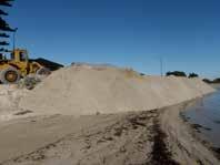
Transcription
1 City of Rockingham Local Management Practices, Costs and Strategic Coastal Planning
2 Decision Making Process Considerations Climate Change Response Action Plan Ongoing observations/major Storm events Ongoing Beach Profile Surveys Geomorphology information gained as part of project planning and development Modelling undertaken as part of project planning and development State Planning Policy Coastal Compartments/Sediment Cell Planning Determining adaption outcomes that meet community expectations and Council Policy Community demand and values Local and State Planning Policies

3 City of Rockingham Localities

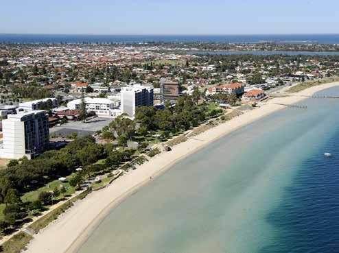
4 Warnbro Sound Beach Rockingham Foreshore
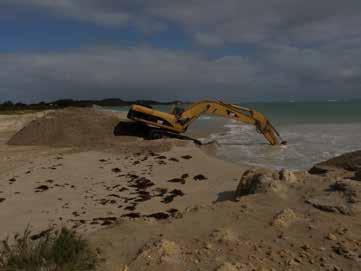
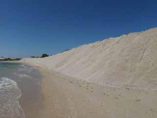
5 Current Issues and Adaption Methods Renourishment Program Annual costs $200,000 approximately Includes excavation works and stockpiling at Point Peron Stockpiling 15,000m3 per year on average

6 Point Peron Accretion and Garden Island Causeway Interruption of normal coastal processes


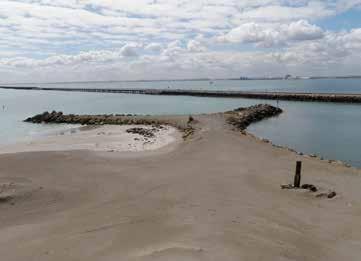
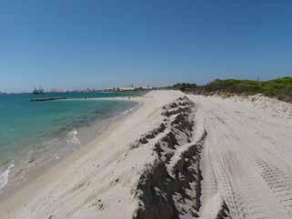
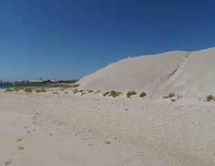
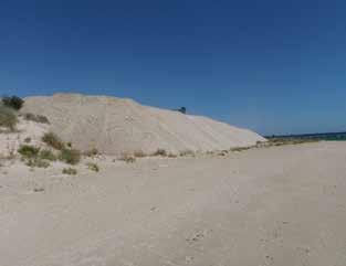
7 Sand Trap and Stockpile Point Peron

8 Cost $450,000 Department of Transport Coastal Protection Grant Point Peron Back Beach with GSC Groyne
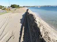
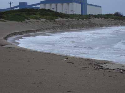
9 Sand Re-nourishment Michael Road Carpark Erosion and Sand Re-nourishment Hymus Street Re-nourishment Waikiki Foreshore Re-nourishment
10 Sand Re-nourishment Kwinana Beach Top of Dune Dune face High Water Mark - North High Water Mark - South


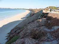
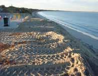
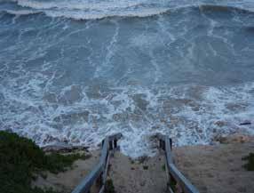
11 Coastal Erosion Point Peron Erosion as at 9 July 2010 Hymus Street Erosion 2008 Hymus Street Erosion 2009 Michael Road Erosion 2009


12 Storm Events Warnbro Foreshore Erosion 2009 Rockingham Sea Wall View Street Erosion 2009 Rockingham Sea Wall Erosion 2009


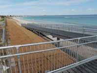
13 Coastal Protection - Seawalls Construction of Waikiki Sea Wall Construction of Mersey Point Sea Wall


14 Waikiki Seawall Cost $640,000

15 Coastal Protection Offshore Headlands Kwinana Beach Headlands

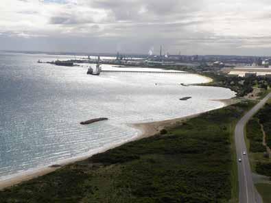
16 Kwinana Headlands

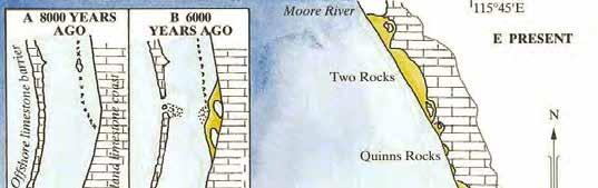
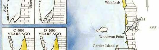
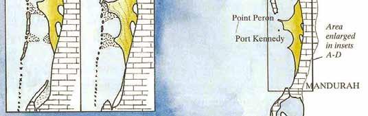
17 Warnbro Sound Erosion and Historical Vegetation Lines

.")
18 Beach Access and Car Parking Figure 5.4 Michael Road Car Park Post July 2009 Storm In 2010, MRA completed a coastal assessment of the Michael Road and View Road car parks. A report was provided which gave concept options for providing protection to these car parks (MRA 2010). Several options for coastal protection were investigated which included a geotextile sand container (GSC) seawall or a rock seawall as shown in the following figure.

19 Michael Road Car Park Set Back Options

20 Michael Road Car Park Dune Alignment

21 View Road Foreshore Conceptual Coastal Protection Estimated Cost $720,000

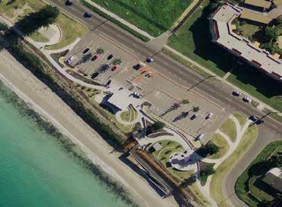
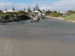
22 Jetties and Boat Ramps Point Peron Boat Launching Facility
23 Recreation Boating Facility Demand Recreation Boating Facilities Study 2009 Rockingham has in excess 10% (DoT Survey 2010) of all registered boats in the Perth Metropolitan area There is a greater proportion of trailered boats in Rockingham Existing ramps experience an extremely high rate of peak demand There is a lack of car parking bays to meet existing demand Expected rise from 4,768 to 6,752 registered boats in Rockingham by 2025

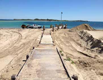
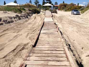
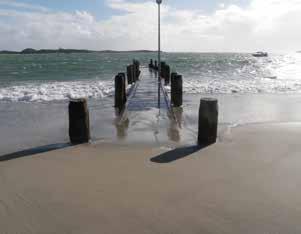
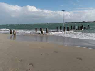
24 Bent Street Navigation Channel Established 2013 Cost $650,000 $75% of cost met through D.o.T Recreational Boating Facility Scheme Grant Modelling of Warnbro Sound Geotech Investigations Accretion due to offshore sand feed Approach to Department of Parks and Wildlife to excavate from Tern Island Navigation Channel 300m long 30m wide and 1.6 2m cd

25 Bent Street Navigation Channel

")
")
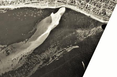
26 Tern Island Aerial Photographs cont d Tern Island sand bar 1989 Tern Island sand bar 1994 (12/94) Tern Island sand bar 1996A (1/96) Tern Island sand bar 1998A (02/98)

")

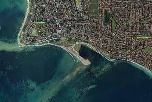
27 Tern Island Aerial Photographs cont d Tern Island sand bar 2000 (12/00) Tern Island sand bar 2005 Tern Island sand bar 2008 Tern Island sand bar 2011


28 Jetties Program Palm Beach Jetty Built 2009 Included Geotechnical Investigations/Wave Modelling $3,200,000 Val Street Jetty Wave Modelling/Geotech Investigations 40m Extension $2,400, metre Reconstruction 2014 $3,800,000

29 Mersey Point Sand Excavation

30 Mersey Point Jetty


31 Mersey Point Jetty and Boardwalk Storm Inundation
32 Mersey Point to Port Kennedy Study Objectives 2012 Present details and projections in relation of littoral sand movement and the impact this along with other elements such as wind and wave action changing sea levels and major storm events have on the current and future boat launching capacity in Warnbro Sound; Identify potential locations for future boat launching facilities within Warnbro Sound and provide layout designs for the development of the boat ramps and the associated infrastructure in these locations; Recommend future development strategies for the sustainable use of Mersey Point including the possible relocation of the existing jetty
33 Why the study was undertaken? Increasing heavy demand for boat launching facilities; Constraints of existing facilities and ramps; Bent Street Navigation Channel Proposal; Mersey Point jetty maintenance and environmental factors; Coastal dynamics resulting in areas of both erosion and accretion; Threats to coastal infrastructure and beach access.
34 Previous studies considered Draft Perth Coastal Planning Strategy (WAPC 2012) Rockingham Foreshore Strategy (Coastwise 2002) Shoalwater Islands Management Plan (DEC 2007) Metropolitan Perth Local Government Areas Recreation Boating Predictions (DPI 2007) and Perth Recreation Boating Facilities Study 2008 (2009) Bent Street Navigational Channel Referral Document Rockingham Foreshore Strategy ( 2012 )
35 Study Methodology Considered previous and current studies and coastal process research undertaken for these waters. Review of coastal process on beaches from Shoalwater to Port Kennedy Wind and wave action / impact possible sea level rise impacts Sediment transport Critical erosion/accretion areas Condition report of existing infrastructure Ongoing maintenance requirements Infrastructure replacement options
36 Beach Profile Survey
37 Beach Profile Survey

38 2G WAVE Spatial Plot of Typical Swell
39 Coastal Environment Geology and Geomorphology
40 Climate Change

41 2010 Population - 101,800 To increase by about 3,000pa 2021 Population Forecast - 136, Population Forecast - 164, Baldivis Population Forecast - 41,000 (Currently 12,000)

42 Planning Precincts along Warnbro Sound
43 Precinct Type & Character Precinct Intensity Shoalwater Built up- residential Low Moderate Major Issues & Planning Considerations Shoalwater Islands Marine Park Physical coastal processes setback encroaches onto residential land and active coastal management may be required Safety Bay Built up- Mixed use Moderate Shoalwater Islands Marine Park Setback requirements and erosion at ends of seawalls Physical coastal processes setback encroaches onto urban and residential zoned land Southern aspect unique on Perth coast Land uses & Features to be Promoted Residential development Active recreation Conservation around islands Café and change rooms along foreshore Active use of foreshore area Cafes, grassed areas, BBQs and picnic areas Dual use path Residential development Small mixed use area Boat Ramp Recommendations Further investigation into coastal management requirements of areas which lie in coastal setback distance Detailed assessment of overtopping strength, durability of Mersey Point Seawall Protection & recognition of Aboriginal heritage site Develop & implement a coastal management plan Waikiki Built up- Residential with mixed use focus Moderate Shoalwater Islands Marine Park Physical coastal processes setback encroaches onto residential land and active coastal management may be required Residential with mixed use focus Retail/office/entertainment Tourism & recreation Family uses with relaxed feel Shade, BBQs, picnic areas Water ski area Dog beach Develop & implement a coastal management plan North Warnbro Open space Passive recreation - Shoalwater Islands Marine Park Physical coastal processes setback encroaches onto developed land Family uses with relaxed feel Sport & recreation Dog Beach Picnic & BBQ areas Residential Car parks & paths Further investigation to determine appropriate management measures Develop & implement a coastal management plan South Warnbro Built up Residential Low Moderate Shoalwater Islands Marine Park Physical coastal processes setback Encroaches onto developed land and active coastal management may be required Foreshore erosion threatening dunes and adjacent road Residential Passive recreation Car parks & paths Designated water ski take off area Low levels of access Further investigation to determine appropriate management measures Develop & implement a coastal management plan

44 Zoning Scheme of the Shoalwater Islands Marine Park
45 Existing Coastal Process Considerations Dynamic Coastline with areas of erosion and accretion and north/south facing beaches Existing hot spots being actively monitored Some wave protection from the Murray Reef System in Warnbro Sound Break in the reef allowing sand infill to be deposited at northern and southern ends of Warnbro Sound


46 Coastal Process Considerations Limited opportunities for additional boat launching and jetty facilities along the coast Garden Island causeway disrupting sand movement along coast Variety of coastal types from sandy beaches to limestone reef Possible future erosion and inundation threats to established public infrastructure and private housing

47 Coastal Management Plan Considerations Consider findings of PNP and CSCA work Consider State Planning Policy Objectives and requirements Consider Shoalwater Island Marine Park Management Plan impacts Determine the community values, objectives, strategic directions for the coast
48 Coastal Management Plan Considerations Local structure plan and / or town planning scheme considerations; Include strategic direction, climate change vulnerability over 100 years and management activities/actions over next 5 10 years in one document Document existing and future coastal infrastructure Collate information and data to be able to provide this information in RFT/RFQ s
49 Coastal Management Plan Proposal Consideration of documented risks of coastal erosion and inundation hazards now? And over next several decades (timeframe of CMP) Gap analysis of CoR coast for coastal data and information and actions to fill gaps Shoreline Data Wave Modelling Geotech Investigations Wider influences (e.g. Leeuwin Current) Climate Change Response and adaption strategies Use CSCA values and assets study to document environmental, heritage and recreational values/ecosystem services of the coast List existing coastal protection structures (seawalls, groynes, breakwaters) and detail current renourishment programs
50 Coastal Management Plan Proposal Use of sediment cell hierarchy in terms of space and time scales Identify stakeholders for each section of coast Consider appropriateness of future developments on the coast Recommend baseline and ongoing coastal zone monitoring/datacollection required for CoR coast by section, and generally, over next 3-5 years Document legislative framework for coastal planning and management in CoR area Present understanding of coastal processes Review and document literature associated with coastal processes, risk management and adaption process
51 Strategy for Coastal Protection and Infrastructure Outcome Sought To develop comprehensive Coastal Management and Infrastructure Plans, for the City of Rockingham s 26km of coastline, that provides a strategic approach to the protection of the coastline, and the development of future coastal infrastructure. These coastal management plans are to:- Identify creeping change Areas threatened as a result of extreme events Define what is considered to be a successful adaption process Prioritise future engineering solutions if required to protect the coast and associated infrastructure. Justify expenditure Further develop existing concept plans for the possible future development of coastal infrastructure and the upgrading/expansion of existing facilities, to meet forecast demand for boat launching facilities, jetties, car parking and beach access. Identify opportunities for the City to develop a joint management approach with private and/or State agencies, towards the protection of certain areas of the coast, and present strategies that will facilitate and foster these joint management approaches. Develop outcomes that are monitored/reviewed
52 Thank you
Coastal Climate Change Vulnerability and Flexible Adaptation Planning: the Cockburn Sound Coastal Alliance Experience
 Coastal Climate Change Vulnerability and Flexible Adaptation Planning: the Cockburn Sound Coastal Alliance Experience Presentation to Climate Change Forum by Doug Vickery Manager Infrastructure Services,
Sunshine Coast Council Coastal Management Overview. January 2016 edition
 Sunshine Coast Council Coastal Management Overview January 2016 edition Mayor Mark Jamieson Mayor s foreword Our impressive beaches are fundamental to our Sunshine Coast lifestyle, economy and coastal
Climate Change and Physical Development Threats, Challenges and Adaptation Responses in Coastal Communities: Grand Riviere, Trinidad
 Climate Change and Physical Development Threats, Challenges and Adaptation Responses in Coastal Communities: Grand Riviere, Trinidad Michelle Mycoo Ph.D. and Michael Sutherland Ph.D. Geomatics Engineering
Coastal hazard assessments in Victoria
 Coastal hazard assessments in Victoria Viktor Brenners viktor.brenners@delwp.vic.gov.au Future Coasts program 4 year program established in 2007. Outputs included: Coastal Digital Elevation Models Victorian
REVETMENT WORKS- MUSKERS BEACH
 REVETMENT WORKS- MUSKERS BEACH Presented by: Arvind Singh Coordinator Infrastructure Projects, Livingstone Shire Council Chris Lancaster Geofabrics Australasia Pty. Ltd. Presentation Topics 1. Background
Empowering Local Action for Coastal Resilience in Massachusetts. Bruce K. Carlisle MA Office of Coastal Zone Management
 Empowering Local Action for Coastal Resilience in Massachusetts Bruce K. Carlisle MA Office of Coastal Zone Management Context Coastal communities continue to face both chronic and acute storm surge, erosion,
Construction of upgraded stormwater outfall at the Ozone Road Jetty
 Construction of upgraded stormwater outfall at the Ozone Road Jetty Background The City of Greater Geelong (CoGG) is responsible for stormwater management within Barwon Heads. There is an existing 750
Tomorrow s Queensland: strong, green, smart, healthy and fair. Queensland Coastal Plan
 Tomorrow s Queensland: strong, green, smart, healthy and fair Queensland Coastal Plan Prepared by: Environment Planning Department of Environment and Resource Management GPO Box 2454 Brisbane Qld 4001
SHORELINE, FLOOD AND COASTAL DEFENCE MANAGEMENT PLANS
 These plans may provide opportunities as well as concern for recreational boating. They are currently being revised and consulted on. This document explains how we can engage in the process. Shoreline,
jmt.com MARINE Part of a diversified family of solutions
 jmt.com MARINE Part of a diversified family of solutions Services Marine & Coastal Engineering Modeling Coastal Initiatives & Techniques Port, Harbor, & Marine Consultancy Small Craft Design Permitting
I604. Hobsonville Marina Precinct
 I604. Hobsonville Marina Precinct I604.1. Precinct description Hobsonville Marina Precinct is located at Clearwater Cove, Hobsonville in Auckland s upper Waitemata Harbour. The precinct includes the coastal
Methodology on Functional Linkage between Marine and Terrestrial Areas
 Methodology on Functional Linkage between Marine and Terrestrial Areas prepared within the frame of the project on Coastal and Maritime Spatial Planning in Pärnu Bay Area and Coastal Municipalities of
Policy for management and protection of the coast
 Policy for management and protection of the coast Policy for management and protection of the coast Mona Ohlsson Samhällsbyggnadsförvaltningen Ystads kommun, 2008 3 THE MUNICIPALITY GUIDELINES REGARDING
CHAPTER Committee Substitute for Senate Bill No. 1472
 CHAPTER 2007-99 Committee Substitute for Senate Bill No. 1472 An act relating to beaches and shores; amending s. 161.021, F.S.; amending a definition; amending s. 161.085, F.S.; restricting the use of
Improvement of the Atlantic Coast of New York City,
 Improvement of the Atlantic Coast of New York City, Rockaway Inlet to Norton Point Project at Sea Gate Meeting Purpose The U.S. Army Corps of Engineers, the New York State Department of Environmental Conservation,
ELLIOTT HEADS STRUCTURE PLAN
 ELLIOTT HEADS STRUCTURE PLAN BACKGROUND This report has been prepared to provide an overview of the land that has been included in the Urban Footprint within the Wide Bay Burnett Regional Plan, September
POLICY SRT/D4 STORMWATER MANAGEMENT
 POLICY SRT/D4 STORMWATER MANAGEMENT BACKGROUND Increasing population, decreasing rainfall and increasing community expectations regarding environmental issues have led to increasing recognition of the
Assessment of Landscape, Visual and Natural Character Effects
 Assessment of Landscape, Visual and Natural Character Effects Consent Footprint Amendments Mangamaunu Half Moon Bay Okiwi Bay South Report prepared for: New Zealand Transport Agency and KiwiRail Holdings
Make park life, part of your life.
 Make park life, part of your life. A shared spirit of community. The centre of family life. Imagine a friendly, welcoming community where sports, and social gatherings. Where tree-lined Baldivis Parks
WATERLOO STATE SIGNIFICANT PRECINCT SUMMARY OF STUDIES
 WATERLOO STATE SIGNIFICANT PRECINCT SUMMARY OF STUDIES Technical studies will be undertaken to inform the master planning process for the Waterloo precinct to develop a Precinct Proposal to redevelop the
ALTERNATIVE SHORELINE MANAGEMENT IN COASTAL MISSISSIPPI
 ALTERNATIVE SHORELINE MANAGEMENT IN COASTAL MISSISSIPPI Project supported via financial assistance provided by the Coastal Zone Management Act of 1972, as amended, administered by the Office of the Ocean
An Integrated Approach for Water Management Examples from The Netherlands. Addressing Climate Change and Sea Level Rise
 An Integrated Approach for Water Management Examples from The Netherlands Addressing Climate Change and Sea Level Rise Superstorm Sandy Forum College of Staten Island March 8 2013 Water: a challenge and
A CONCEPTUAL PROPOSAL BY THE UMDLOTI FORUM Representing the Umdloti Ratepayers and Residents Association and the emdloti UIP
 A CONCEPTUAL PROPOSAL BY THE UMDLOTI FORUM Representing the Umdloti Ratepayers and Residents Association and the emdloti UIP PRESENTATION STRUCTURE 1.0 Overview of Umdloti 2.0 Current challenges in Umdloti
H7 Open Space zones. (a) provide for the needs of the wider community as well as the needs of the community in which they are located;
 provide for the needs of the wider community as well as the needs of the community in which they are located;") H7. Open Space zones H7.1. Background The majority of land zoned as open space is vested in the Council or is owned by the Crown. However some areas zoned open space are privately owned. While the open
H7. Open Space zones H7.1. Background The majority of land zoned as open space is vested in the Council or is owned by the Crown. However some areas zoned open space are privately owned. While the open
.MANAGED RETREAT. Need for managed retreat
 602 MANAGED RETREAT hazards. This strategy is based on a philosophy of moving out of harm's way, and is proactive in recognizing that the dynamics of the coastal zone should dictate the type of management
Goals and Strategies. Goals. Strategies. Long-term Beach and Shoreline Management Program
 Goals and Strategies Goals Long-term Beach and Shoreline Management Program Qualify for and Maintain Static-line Exception Qualify for and Maintain FEMA Engineered Beach Lockwoods Folly Inlet Management
Coastal Erosion Protection Strategies Private Works on Public Land
 Coastal Erosion Protection Strategies Private Works on Public Land Arron Broom Coastal Policy Planner Coastal Management Branch, SA DEW Delegate for the Coast Protection Board 2016 Storm Events SA experienced
BEACH AND INLET PROJECTS UPDATE
 BEACH AND INLET PROJECTS UPDATE USACE DELTA PROJECT USACE Delta Project Project Extents Elevation Elevation (ft NAVD88) (ft NAVD88) USACE Delta Project Project Cross-Section 20 18 20 16 18 14 16 12 14
A. INTRODUCTION B. CUMULATIVE EFFECTS ANALYSIS
 Chapter 4: Cumulative Effects A. INTRODUCTION The New York City Department of Parks and Recreation plans to reconstruct the Rockaway Beach Boardwalk in the borough of Queens, New York City, which Hurricane
Settlement Boundaries Methodology North Northumberland Coast Neighbourhood Plan (August 2016)
") Introduction This background paper sets out a methodology for the definition of settlement boundaries in the North Northumberland Coast Neighbourhood Plan. The neighbourhood plan is planning positively
Introduction This background paper sets out a methodology for the definition of settlement boundaries in the North Northumberland Coast Neighbourhood Plan. The neighbourhood plan is planning positively
Rhode Island Shoreline Change Special Area Management Plan
 Rhode Island Shoreline Change Special Area Management Plan Draft Document Outline REVISED 10/12/2017 VOLUME 1 Executive Summary & How to Use this Document (Draft by Dec 2017) 1. Introduction (Revised draft
Appendix to Amicus Curiae Brief: Selected Provisions of the South Carolina Beachfront Management Act
 Loyola Marymount University and Loyola Law School Digital Commons at Loyola Marymount University and Loyola Law School Loyola of Los Angeles Law Review Law Reviews 6-1-1992 Appendix to Amicus Curiae Brief:
Sierra Club Comments on ACOE Public Notice NAE Re: Proposed Town Neck Beach Project at Sandwich, Massachusetts
 August 27, 2015 US Army Corps of Engineers New England District 696 Virginia Road Concord, MA 01742-2751 Attn: Phillip W. Nimeskern Dear Mr. Nimeskern, Sierra Club Comments on ACOE Public Notice NAE-2014-259
INCREMENTAL CHANGE AREA REVIEW March 2015 Page 1
 INCREMENTAL CHANGE AREA REVIEW March 2015 Page 1 Table of Contents Introduction... 3 Background to Review... 3 Comparison of the Schedules to the General Residential Zone... 7 Methodology... 7 Policy Context...
Broward County Shore Protection Project Segment II. Physical Monitoring Plan
 Broward County Shore Protection Project Segment II USACE File No. SAJ-1999-05545 Broward County Shore Protection Project -Segment II Submitted To: Florida Department of Environmental Protection Office
The Process. Phase 1: Detailed Assessment, Design Framework Phase 2: Conceptual Design. Phase 3: Master Plan Document
 Background The Ship Point master planning process was initiated in March of 2017 to advance policy direction from Harbour Vitality Principles (2014) Ship Point design and initial implementation a key action
CITY OF FREMANTLE LOCAL PLANNING SCHEME NO. 4 AMENDMENT NO. 68 SCHEME AMENDMENT REPORT
 CITY OF FREMANTLE LOCAL PLANNING SCHEME NO. 4 AMENDMENT NO. 68 SCHEME AMENDMENT REPORT CITY OF FREMANTLE PLANNING AND DEVELOPMENT SERVICES 8 WILLIAM STREET FREMANTLE WA 6160 PLANNING AND DEVELOPMENT ACT
Proposed Pedestrian and Cycle Routes. Headland to Spit Great Ocean Walk and coastal path network* (Regional scale path)
") four strategies access and movement The access and movement strategy for the Master Plan aims to promote healthy, active and sustainable movements to and through Mooloolaba. Pedestrian and Cycle A lack
four strategies access and movement The access and movement strategy for the Master Plan aims to promote healthy, active and sustainable movements to and through Mooloolaba. Pedestrian and Cycle A lack
NJ Department of Environmental Protection
 NJ Department of Environmental Protection COASTAL AND LAND USE PLANNING New Jersey Coastal Management Program Covers NJ coastal waters to limit of tidal influence including 239 municipalities in 19 counties,
TONIGHT S MEETING DRAFT SUMMARY REPORT CAPE WOOLAMAI COASTAL RESERVES MASTER PLAN PHILLIP ISLAND SOUTH AND NORTH COAST KEY AREA PLAN OCTOBER 2014
 TONIGHT S MEETING Phillip Island Nature Parks and Bass Coast Shire Council have partnered to achieve a comprehensive and integrated master plan for the safe use and management of Cape Woolamai Coastal
Harbour-front Enhancement Committee. Wan Chai Development Phase II. Planning and Engineering Review
 Paper No. 4/2004 For discussion on 6 May 2004 Harbour-front Enhancement Committee Wan Chai Development Phase II Planning and Engineering Review PURPOSE This paper briefs Members on the scope, approach,
CURL CURL BEACH LANDSCAPE DRAFT MASTERPLAN
 LANDSCAPE 03 04 05 07 06 08 LANDSCAPE KEY BENEFITS OPEN SPACE EXISTING = 25600m2 PROPOSED = 29000m2 NATURAL/LANDSCAPED AREA EXISTING = 36200m2 PROPOSED = 38450m2 PARKING SPACES MAIN CAR PARK EXISTING =
July 22, 2013 REQUEST FOR PROPOSALS TO PROVIDE ENGINEERING DESIGN SERVICES FOR A PROJECT ALONG THE WESTERN SHORE OF MOBILE BAY
 Mobile Bay National Estuary Program 4172 Commanders Drive Mobile, AL 36615 Phone: 251-431-6409 Fax: 251-431-6450 Contact: Tom Herder, Watershed Protection Coordinator Email: therder@mobilebaynep.com July
Welcome! HORSESHOE BAY PARK. Welcome!
 Welcome! HORSESHOE BAY PARK Welcome! Where are we in the process? Today we would like your input on how Horseshoe Bay Park can be upgraded to serve the community s needs better. CONSULT STAKEHOLDERS TAKE
project background relationship to the spit Guiding Principles Mooloolaba Spit Futures Plan (2009) Vision one
 Vision one") one project background relationship to the spit The Spit is an important part of Mooloolaba and a key contributor to the natural beauty of the town. The Spit is cherished by local residents and visitors
one project background relationship to the spit The Spit is an important part of Mooloolaba and a key contributor to the natural beauty of the town. The Spit is cherished by local residents and visitors
Ashbridges Bay Erosion and Sediment Control Project
 Ashbridges Bay Erosion and Sediment Control Project Project Brief Overview Toronto and Region Conservation Authority, in partnership with the City of Toronto, intends to carry out remedial erosion control
Final Report 19 December Job number
 Palm Island Aboriginal Shire Council and the Remote Indigenous Land and Infrastructure Program Office Palm Island Aboriginal Shire Planning Scheme Palm Island Planning Scheme - The Way Forward 222099 Final
State of the State New Jersey. Steve Jacobus NJDEP 06/10/15
 State of the State New Jersey Steve Jacobus NJDEP 06/10/15 1980s Living shorelines term coined in MD 2003 North Carolina passes Living Shoreline Law (HB 1028) early 2000s Delaware puts no bulkhead policy
2013 Summer Recap. Rockaway Beach
 2013 Summer Recap and Discussion on Rockaway Beach Reconstruction Tonight s Agenda Summer Beach Update Phase 2 Assumptions, Constraints and Regulations Rebuilding the Boardwalk Coastal Protection Rockaway
Coastal safety- case studies in Flanders
 Coastal safety- case studies in Flanders Duinkerke, June 12th 2018 ir. Daphné Thoon MDK-Coastal Division Content 1. Introduction 2. Coastal Safety Masterplan - status 3. Management of the sandy coast 4.
CAMA LAND USE PLAN TOWN OF KITTY HAWK IMPLEMENTATION STATUS REPORT 2013
 Post Office Box 549 101 Veterans Memorial Drive Kitty Hawk, NC 27949 Phone (252) 261-3552 Fax (252) 261-7900 www.townofkittyhawk.org CAMA LAND USE PLAN TOWN OF KITTY HAWK IMPLEMENTATION STATUS REPORT 2013
Tāhuhu whakaruruhau ā-taone The sheltering ridge pole
 B2. Tāhuhu whakaruruhau ā-taone - Urban growth and form B2.1. Issues Tāhuhu whakaruruhau ā-taone The sheltering ridge pole Auckland s growing population increases demand for housing, employment, business,
Queensland Coastal Plan. Presented by John Lane Director Environment Planning
 Queensland Coastal Plan Presented by John Lane Director Environment Planning Queensland Coastal Plan - Status Released 7 April 2011, but NOT YET IN EFFECT Formatting & operational amendments required Yet
Port Macquarie Town Centre Landscape Architects
 Port Macquarie Town Centre Town Green Master Plan Review Tract Landscape Architects Urban Designers Town Planners A review of the Town Green Master Plan Port Macquarie, New South Wales Prepared by Tract
Natural Resource Adaptation Action Area Addressing Sea Level Rise in Estuarine Ecosystems TO: TOWN OF YANKEETOWN MAY
 Natural Resource Adaptation Action Area Addressing Sea Level Rise in Estuarine Ecosystems TO: TOWN OF YANKEETOWN MAY 6 2013 University of Florida Conservation Clinic Vivek Babbar, Student Associate, J.D.
PRIORITIES FOR A SUSTAINABLE SHOALHAVEN COASTLINE. The Shoalhaven Coastal Zone Management Plan
 Shoalhaven City Council EXECUTIVE SUMMARY PRIORITIES FOR A SUSTAINABLE SHOALHAVEN COASTLINE The Shoalhaven Coastal Zone Management Plan March 2009 How Shoalhaven City Council is working towards a resilient
The Louisiana 2017 Coastal Master Plan: Climate Change and Sea Level Rise Planning in the International Context
 The Louisiana 2017 Coastal Master Plan: Climate Change and Sea Level Rise Planning in the International Context Dr. Michael K. Orbach Professor Emeritus of Marine Affairs and Policy Nicholas School of
DRAFT GREATER SYDNEY REGION PLAN OBJECTIVES, STRATEGIES AND ACTIONS
 Greater Sydney Commission DRAFT GREATER SYDNEY REGION PLAN OBJECTIVES, STRATEGIES AND ACTIONS Issued: 26 OCTOBER 2017 Version: 1 Subject: Greater Sydney Region and District Plans This information note
Implementing sustainable water strategy through development industry engagement
 Implementing sustainable water strategy through development industry engagement Ian Director, Organica Engineering, Melbourne, Australia E-mail: iadams@organicaeng.com.au Edward Cotter Sustainability Leader,
Public Workshop #3. Sea Level Rise Vulnerability Assessment. Infrastructure Property Cultural Civic Coastal Amenities Ecological
 Infrastructure Property Cultural Civic Coastal Amenities Ecological Public Workshop #3 Sea Level Rise Vulnerability Assessment Funded in part by CCC Grant LCP-14-09 Introducing the Team: Purpose of Today
Severn Estuary Shoreline Management Plan What does it mean for planning in North Somerset?
 Severn Estuary Shoreline Management Plan What does it mean for planning in North Somerset? Coastal planning The National Planning Policy Framework sets out the Government s planning policies for England.
Port of San Diego Sea Level Rise Ad Hoc Committee Meeting 1 of 3.. September 18, 2018
 Port of San Diego Sea Level Rise Ad Hoc Committee Meeting 1 of 3. September 18, 2018 Agenda Welcome Introductions Rules of the Ad-Hoc Presentation Background Vulnerability Assessment Results Non-Agenda
Living Shoreline Professionals Advanced Training. August 24 & 31, 2017 Hosted by Virginia Institute of Marine Science College of William & Mary
 Living Shoreline Professionals Advanced Training August 24 & 31, 2017 Hosted by Virginia Institute of Marine Science College of William & Mary LIVING SHORELINE PROFESSIONALS ADVANCED TRAINING AUGUST 2017
Virginia Beach and Sea Level Rise: Where Do We Go From Here?
 Virginia Beach and Sea Level Rise: Where Do We Go From Here? Clay Bernick City of Virginia Beach Environment & Sustainability Office Bayfront Advisory Committee Presentation July 19, 2012 Five Items to
Appendix H: Easement cross sections
 Appendix H: Easement cross sections SHARED PATH 1.5m FOOTPATH NATURE STRIP 7.3m CARRIAGEWAY 2.7m NATURE STRIP EXISTING PIPELINE 150mm DIA 5.0m (approx.) LOCAL ACCESS ROAD EXISTING PIPELINE 500mm DIA 2.7m
Coastal Planning in Texas. Tony Williams Senior Director of Planning Coastal Resources Division Texas General Land Office
 Coastal Planning in Texas Tony Williams Senior Director of Planning Coastal Resources Division Texas General Land Office e The Texas General Land Office (GLO) and the Texas Coast Since 1836: Manager of
With a World of Heritage So Rich
 With a World of Heritage So Rich Lessons from Across the Globe for U.S. Historic Preservation in its Second 50 Years The steps to prioritizing and undertaking action at sites threatened by climate change
HARTENBOS NORTH (population: Census 2011)
") 5.8 HARTENBOS NORTH (population: + 184 Census 2011) Figure 5.8.1.1 Hartenbos North: Aerial photograph CNdV africa (Pty) Ltd DRAFT CONCEPTUAL DEVELOPMENT FRAMEWORK REPORT page 439 5.8.1 SPATIAL ANALYSIS,
5.8 HARTENBOS NORTH (population: + 184 Census 2011) Figure 5.8.1.1 Hartenbos North: Aerial photograph CNdV africa (Pty) Ltd DRAFT CONCEPTUAL DEVELOPMENT FRAMEWORK REPORT page 439 5.8.1 SPATIAL ANALYSIS,
Hobart A Strategic Framework
 Hobart 2025 A Strategic Framework Adopted by the Hobart City Council 15 October 2007 Table of Contents Introduction...2 Vision and Future Directions...3 FD1 Offers opportunities for all ages and a city
04Design. Methodology. Future of Jacksons Hill Identifying Potential Uses Building Typology and Adaptability Community Engagement
 Jacksons Hill Adaptive Re-Use Study 25 04Design Methodology Objectives Future of Jacksons Hill Identifying Potential Uses Building Typology and Adaptability Community Engagement Jacksons Hill Adaptive
Karen A. Duhring Marine Advisory Scientist Center for Coastal Resources Management Virginia Institute of Marine Science College of William & Mary
 Karen A. Duhring Marine Advisory Scientist Center for Coastal Resources Management Virginia Institute of Marine Science College of William & Mary March 20, 2009 Low-Impact Shoreline Stabilization Cumulative
Coast Protection, Development and Coastal Biodiversity. Brian Caton Member CEMAC, AMLR NRM Former Chair & Member, Coast Protection Board
 Coast Protection, Development and Coastal Biodiversity Brian Caton Member CEMAC, AMLR NRM Former Chair & Member, Coast Protection Board Saltmarsh: an extensive problem for Biodiversity and Planning Law
Legal implications of failing to
 Legal implications of failing to plan for sea level rise Gavin Leydon, Partner 30 April 2010 Outline Relevance to local l government & developers assessment & policy Developments in case law Climate change
Developing the Joint Action Plan
 Developing the Joint Action Plan MAJOR COSTAL PROJECTS 1. TITLE OF THE PROJECT: Larnaca North Coastal Redevelopment Project 2. BRIEF DESCRIPTION OF THE TYPOLOGY OF THE PROJECT (max ½ or 1 page) - Hard
Public Meeting #3 May 9, 2009 MVVA Team
 Public Meeting #3 May 9, 2009 MVVA Team Welcome to the third Public Meeting for the Lower Don Lands Municipal Class Environmental Assessment (EA) Infrastructure Master Plan and Keating Channel Precinct
Purpose of Open House #3
 Public Meeting #3 May 9, 2009 MVVA Team Purpose of Open House #3 The main purpose of this Open House is to present and seek input on the: Evaluation of transportation and infrastructure design alternatives
Suffolk Coastal Local Plan Review Issues and Options, August 2017, Public Consultation
 Suffolk Coastal Local Plan Review Issues and Options, August 2017, Public Consultation Having reviewed the issues and options documents, the Society has made the following response: Part 1 - Strategic
Mitigation + Adaptation Strategies for Historic Structures and Sites
 Mitigation + Adaptation Strategies for Historic Structures and Sites Adrienne Burke, Esq., MSAS, LEED AP+ Executive Director, Riverside Avondale Preservation, Jacksonville, FL Cultural Resources, Disaster
Appendix 1 Structure plan guidelines
 Appendix 1 Structure plan guidelines This appendix forms part of the regional policy statement [rps]. 1.1. Introduction Structure plans are an important method for establishing the pattern of land use
Maroochy River Mouth Cost-Benefit Assessment
 Maroochy River Mouth Cost-Benefit Assessment Final Report June 2017 Sunshine Coast Council Locked Bag 72 Sunshine Coast Mail Centre QLD 4560 JBA Project Manager Daniel Rodger Jeremy Benn Pacific Level
GREEN BELTS, GREEN WEDGES OR DISPUTED GROUND
 GREEN BELTS, GREEN WEDGES OR DISPUTED GROUND John Ginivan Department of Planning and Community Development State Government of Victoria Melbourne Australia Greenbelts: Local Solutions for Global Challenges
Blue/Green Infrastructure Study Accomack County, VA
 Blue/Green Infrastructure Study Accomack County, VA Draft Asset Maps March 8-9, 2010 Green Infrastructure Center, Inc. 2 Overview What is Green and Blue Infrastructure Project Timeline & Tasks Literature
Beneficial Use at Deer Island A Decade of Design and Implementation. Mississippi Water Resources Conference Jackson, Mississippi April 3, 2012
 Beneficial Use at Deer Island A Decade of Design and Implementation Presented by Wendell Mears and William Roth Anchor QEA, LLC Mississippi Water Resources Conference Jackson, Mississippi April 3, 2012
NC Division of Coastal Management
 November 14, 2016 NC Division of Coastal Management NCBIWA Update NC Coastal Area Management Act (1974) Balances competing coastal pressures through development permitting and creation of a Coastal Resources
Plan Modification to Chapter B2 of the Auckland Unitary Plan(AUP) Operative in part (15 November 2016)
 Operative in part (15 November 2016)") UNITARY PLAN UPDATE REQUEST MEMORANDUM TO FROM Phill Reid Linley Wilkinson DATE 25 September 2018 SUBJECT Plan Modification to Chapter B2 of the Auckland Unitary Plan(AUP) Operative in part (15 November
UNITARY PLAN UPDATE REQUEST MEMORANDUM TO FROM Phill Reid Linley Wilkinson DATE 25 September 2018 SUBJECT Plan Modification to Chapter B2 of the Auckland Unitary Plan(AUP) Operative in part (15 November
Planning Proposal Concurrent DA/LEP Amendment for Belmont North Pharmacy Amendment No. 24 to Lake Macquarie Local Environmental Plan (LMLEP) 2014
 2014") Planning Proposal Concurrent DA/LEP Amendment for Belmont North Pharmacy Amendment No. 24 to Lake Macquarie Local Environmental Plan (LMLEP) 2014 Local Government Area: Name of Draft LEP: Subject Land:
Planning Proposal Concurrent DA/LEP Amendment for Belmont North Pharmacy Amendment No. 24 to Lake Macquarie Local Environmental Plan (LMLEP) 2014 Local Government Area: Name of Draft LEP: Subject Land:
10.0 Open Space and Public Realm
 10.0 Open Space and Public Realm 10.0 Open Space and Public Realm The Public Open Space System is comprised of: outdoor spaces available for public use that are either publicly owned (e.g., parks and
6. THE COAST POLICY INDEX
 6. THE COAST POLICY INDEX LP/C1 Development within the Coastal Zone Page 90 LP/C2 Piers & Harbours Page 92 LP/C3 Fish Farms Page 94 LP/C4 Coastal Erosion Page 96 THE ORKNEY LOCAL PLAN - Coastal Policies
Evidence-based Assessment of Natural Character
 Evidence-based Assessment of Natural Character RMLA Waikato Branch 07 Sept 2016 Michael Steven Landscape Architect/Landscape Planner Pohara, Golden Bay 1 The key issue. The adequacy of landscape & natural
Master Plan for Preservation and Scenic Conservation (1995)
") 3.2 Master Plan for Preservation and Scenic Conservation (1995) The Master Plan for Preservation and Scenic Conservation was developed under the direction of the Guilford Preservation Alliance in the 1980s
3.2 Master Plan for Preservation and Scenic Conservation (1995) The Master Plan for Preservation and Scenic Conservation was developed under the direction of the Guilford Preservation Alliance in the 1980s
LANDSCAPE GUIDELINES. Countryside & Coastal Countryside Environments. Landscape, Natural Character & Amenity Values Guide
 Landscape, Natural Character & Amenity Values Guide Copyright WDC 2009 Version A2 18May09 Environmental Services Group Publication Countryside & Coastal Countryside Environments START HERE Quality Land
NC Coastal Management Program Update. Mike Lopazanski Policy & Planning Section Chief April 3, 2015
 NC Coastal Management Program Update Mike Lopazanski Policy & Planning Section Chief April 3, 2015 NC Coastal Area Management Act (1974) Balances competing coastal pressures through development permitting
Planning Proposal Charlestown Swim and Leisure Centre LEP Amendment
 Planning Proposal Charlestown Swim and Leisure Centre LEP Amendment Amendment No. 4 to Lake Macquarie Local Environmental Plan 2014 (PP_2014_LAKEM_005_00) Local Government Area: Name of Draft LEP: Lake
Townsville Coastal Hazard Adaptation Strategy pilot project adaptation decision-making in practice
 Townsville Coastal Hazard Adaptation Strategy pilot project adaptation decision-making in practice Author Harper, Bruce, Smith, Mitchell, Weir, Nick, Wall, Carol, Lane, John, Erhart, Dorean, Anderson,
REPORT. Thames Coromandel District Council. Buffalo Beach Trial Groyne. Resource Consent Application and Assessment of Effects on the Environment
 REPORT Resource Consent Application and Assessment of Effects on the Environment Report prepared for: Report prepared by: Tonkin & Taylor Ltd Distribution: Tonkin & Taylor Ltd (FILE) Waikato Regional Council
Appendix A. Planning Processes. Introduction
 1 Planning Processes Introduction This appendix outlines a number of planning processes which are used in the Auckland Region to support the effective management of development in the region s rural and
Natural & Nature-Based Solutions for Risk Reduction & Resilience
 University of Massachusetts Amherst ScholarWorks@UMass Amherst International Conference on Engineering and Ecohydrology for Fish Passage International Conference on Engineering and Ecohydrology for Fish
Use of sand-filled geotextile tubes for sustainable coastal protection-case studies in Indian scenario
 Indian Journal of Marine Sciences Vol. 43(7), July 2014, pp. Use of sand-filled geotextile tubes for sustainable coastal protection-case studies in Indian scenario M.D.Kudale *, A.V.Mahalingaiah & B.R.Tayade
Executive Office of Energy and Environmental Affairs Massachusetts Vulnerability Preparedness Program. June 6, 2018
 Executive Office of Energy and Environmental Affairs Massachusetts Vulnerability Preparedness Program June 6, 2018 Presentation Outline: 1. What Natural Hazards Impact Falmouth 2. Coastal Resiliency Efforts
PLANNING PROPOSAL Draft Amendment to Wyong LEP 1991
 PLANNING PROPOSAL Draft Amendment to Wyong LEP 1991 9-11 and 31-39 The Entrance Road West, 1-11 and 4 Bent Street (and Bent Street itself), 3-9 and 6 Oakland Avenue (and part of this road) and 2,3 & 4