2.0 PROJECT DESCRIPTION
|
|
|
- Dinah Shepherd
- 5 years ago
- Views:
Transcription
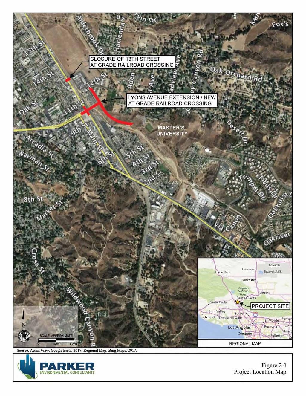
1 2.0 PROJECT DESCRIPTION 2.1 PROJECT LOCATION The Project Site is located in the City of Santa Clarita, California, about 35 miles north of Downtown Los Angeles. The Project Site is more specifically located in the Newhall community of the City of Santa Clarita at the intersection of Lyons Avenue and Railroad Avenue and extends eastward towards the General Plan alignment for Dockweiler Drive towards The Master s University and northwest towards the intersection of 12 th Street and Arch Street. The limits for the Lyons Avenue/Dockweiler Drive extension ( Project Site ) are from Railroad Avenue on the west to the future Master s University Master Plan Dockweiler extension to the east (see Figure 2-1, Project Location Map). Regional Access Regional access to the Project Site is provided from the State Route 14 Freeway to the east and the Golden State/Santa Ana Freeway (I-5) Freeway to the west. SR-14 is located 1.9 miles southeast of the Project Site via Railroad Avenue and Newhall Avenue. The I-5 Freeway is located 2.1 miles west of the Project Site via Lyons Avenue. The SR-14 and I-5 Freeways run in a north-south direction and provides connections to the Ronald Reagan (CA-118) freeway, the San Diego (I-405) freeway, and the Foothill (I- 210) freeway to south of the Project Site. Local Access The following roadways provide local access to the Project Site: Dockweiler Drive is designated as an east-west secondary highway and consists of one and two lanes of travel in each direction. Lyons Avenue is an east-west major roadway that provides three lanes of travel in each direction and provides access from the project area to I-5. Newhall Avenue is a north-south secondary highway from Lyons Avenue to Railroad Avenue with one lane of travel in each direction. From Railroad Avenue to SR-14, Newhall Avenue is designated as a major highway with three northbound lanes and three southbound lanes south of Railroad Avenue. Placerita Canyon Road, west of SR-14 is an east-west local street with one lane of travel provided in each direction. Through traffic access on Placerita Canyon Road is restricted with a gate entrance west of Sierra Highway. Placerita Canyon Road is currently the primary connection to The Master s University and residential neighborhood to the north. Railroad Avenue is a north-south secondary highway from Lyons Avenue to Newhall Avenue. This roadway provides two lanes of travel in each direction and limited parking throughout the project area. 13 th Street is an east-west unimproved local roadway with one lane of travel in each direction and provides a connection to Placerita Canyon Road. Lyons Avenue/Dockweiler Drive Extension Project 2. Project Description SCH No Page 2-1
2
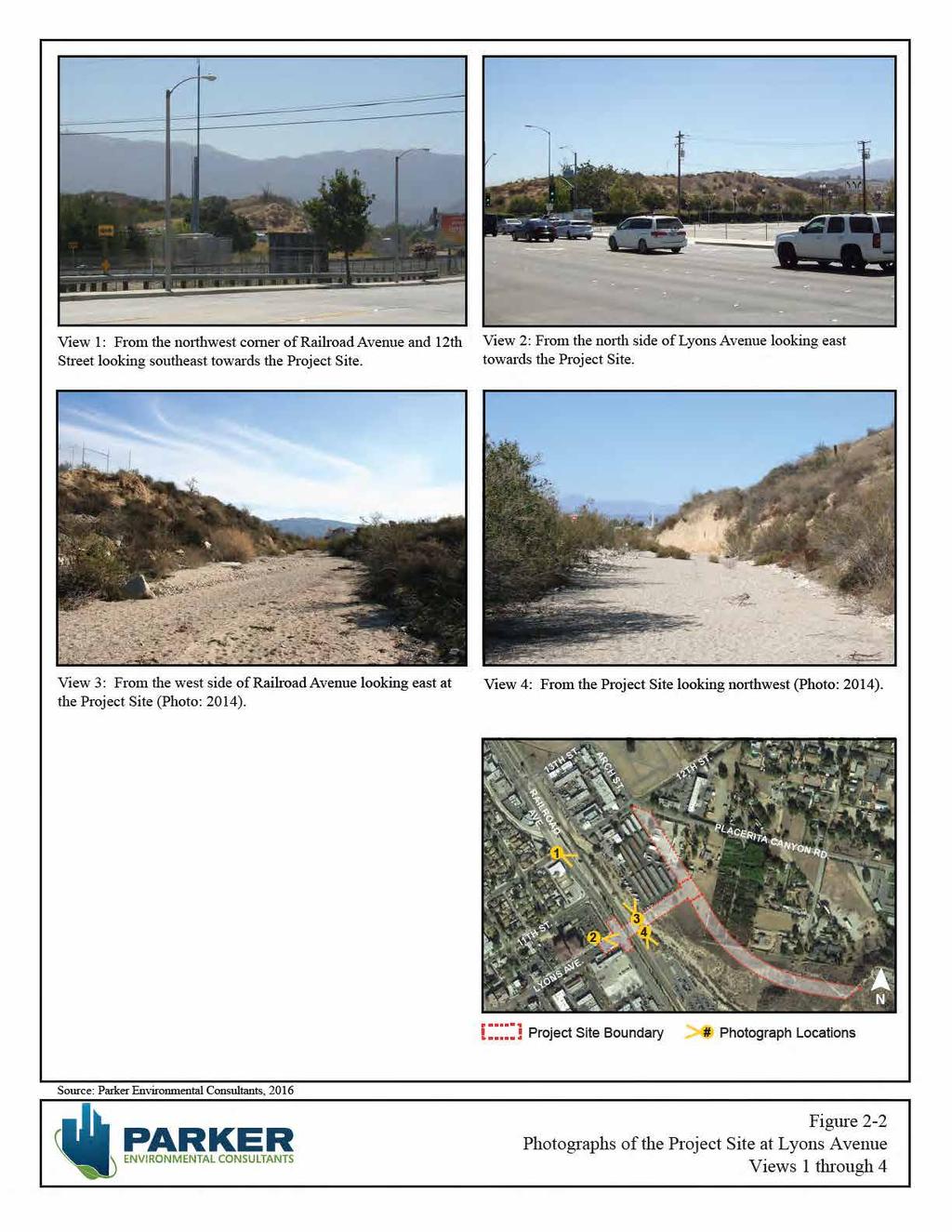
3 City of Santa Clarita August 2017 Transit Services The existing Union Pacific/Metrolink rail line currently extends through the City, and is shared by both freight (Union Pacific) and passenger (Metrolink Antelope Valley line) trains. The nearest Metrolink train station to the Project Site is the Jan Heidt Newhall station located at Railroad Avenue and Market Street, approximately 0.25 mile south of Lyons Avenue. The Newhall station provides passenger service southbound to Los Angeles and northbound to Lancaster. The Newhall station also provides connections to the City s local bus lines 1, 2, 4, 5, 6, 14 and 757. Additionally, the City s Bicycle Master Plan is proposing a Class I Bike Path and Class II Bike Lane in the immediate vicinity of the Project Site, which will improve bicycle and pedestrian circulation. 2.2 ENVIRONMENTAL SETTING The Project Site consists of improved segments of Railroad Avenue and Lyons Avenue roadways and undeveloped land to the east extending towards The Master s University and Arch Street. The west end of the Project Site encompasses portions of Newhall Creek and traverses a storage yard, utilized by Los Angeles County Department of Public Works, and private properties. The portion of the Project Site that includes the intersection of Railroad Avenue and 13 th Street is developed with existing road surface and an at-grade crossing. The UP/Metrolink Railroad line crosses the Project Site east of the intersection of Railroad Avenue and Lyons Avenue and at the intersection of Railroad Avenue and 13 th Street. The proposed road alignments are located on the alluvial flood plain and hillside areas adjacent to Newhall Creek. The Project Site is covered with light to moderate growth of natural grasses and chaparral. Elevations at the Project Site range from approximately 1255 feet to 1370 feet above mean sea level. The current conditions of the Project Site at Railroad Avenue and Lyons Avenue are depicted in Figures 2-2 and 2-3 (Views 1 through 8). The current conditions of the Project Site at Railroad Avenue and 13 th Street are depicted in Figures 2-4 (Views 9 through 12). Placerita Canyon Community The Project Site is located immediately southwest of the Placerita Canyon community. The City of Santa Clarita s General Plan (General Plan) describes the Placerita Canyon community as a rural, equestrianoriented residential area, which is located northeast of Old Town Newhall. East of SR-14, Placerita Canyon is predominantly undeveloped with much of the land contained in the Angeles National Forest. Placerita Canyon is home to The Master s University, a private four-year liberal arts institution, and the Placerita Canyon Nature Center. The General Plan states that planning issues in Placerita Canyon include; accommodating expansion plans for The Master s University; upgrading non-compliant older structures; extending sewer lines to serve existing uses throughout the area to protect groundwater quality; providing flood control and drainage improvements; providing additional vehicular access, possibly through extension of Dockweiler Drive; and opportunities for future development of the 100-acre site located at the westerly entrance of Placerita Canyon. In addition, development in the area must comply with the City s Special Standards District to maintain the rural community character desired by residents. Lyons Avenue/Dockweiler Drive Extension Project 2. Project Description SCH No Page 2-3
4
5
6
7 City of Santa Clarita August 2017 Old Town Newhall Community The Project Site is located immediately east and south of Old Town Newhall. As described in the Old Town Newhall Specific Plan (Specific Plan), Newhall was the earliest permanent settlement in the Santa Clarita Valley. Access to Old Town Newhall is provided by three commercial arterial corridors, which include, Railroad Avenue, Lyons Avenue and Newhall Avenue. Old Town Newhall is composed of two neighborhoods, which are separated from one another by the railroad and Downtown, a 15-block Downtown area and the three existing commercial arterial corridors. Old Town Newhall is characterized by commercial uses along Main Street and Lyons Avenue and multi-family and single-family residential uses north and south of Lyons Avenue. William S. Hart Park, Newhall Creek and a number of historic buildings add to the character of the community. The General Plan states that planning issues for Newhall include the implementation of the Specific Plan through redevelopment efforts, creating a mixed use, transit-oriented, pedestrian-friendly, live-work-play environment, the future extension of Dockweiler Drive to Lyons Avenue, the future expansion of The Master s University campus, and providing any needed drainage infrastructure improvements. The Master s University and Dockweiler Drive Extension The Master s University is a private four-year liberal arts college located in the Placerita Canyon and Newhall community of Santa Clarita. The Master s University was founded in 1927 in downtown Los Angeles and moved to Placerita Canyon in The Master s University offers undergraduate degrees in 13 majors from nearly 60 areas of study, and three Master of Arts degrees in biblical counseling, biblical studies, and education. The Master s University campus is approximately 100 acres in size and has a population of over 1,000 students. The Master s University Master Plan (Master Plan) was approved in 2009 and was designed to guide campus growth over the next ten years. The Master Plan ensures development is consistent with the goals, objectives, principles and policies of stakeholders including the City of Santa Clarita and local community. Key features of the Master Plan include the expansion and addition of educational facilities and dormitories and the construction of a new auditorium. In order to accommodate the future expansion of the campus, the Master Plan includes the proposed extension of Dockweiler Drive from its current terminus near Valle Del Oro, through The Master s University property south of the main campus, to the western boundary of The Master s University property. The extension of Dockweiler Drive is a critical east-west link that would provide a through connection from Sierra Highway to Lyons Avenue. The extension would also relocate the main entry to The Master s University from Placerita Canyon Road and redirect traffic from Placerita Canyon Road onto Dockweiler Drive. Lyons Avenue/Dockweiler Drive Extension Project 2. Project Description SCH No Page 2-7
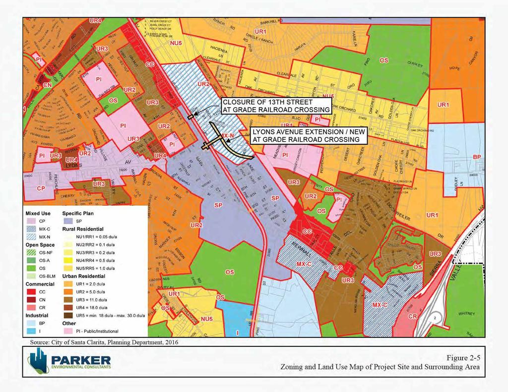
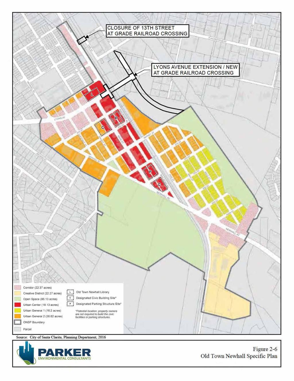
8 City of Santa Clarita August ZONING AND LAND USE DESIGNATIONS Pursuant to the Santa Clarita Municipal Code (SCMC), the portion of the Project Site located at 13 th Street and Railroad Avenue and Lyons Avenue and Railroad Avenue is currently zoned for MXN (Mixed Use Neighborhood). The portion of the Project Site that crosses the UP/Metrolink Railroad line is zoned for PI (Public Institutional). The General Plan land use designation of the Project Site is Mixed Use Neighborhood (MXN). The General Plan states that areas with a MXN designation should be developed to create neighborhoods that combine residential uses with complementary commercial services, including retail and office uses. MXN zoned areas should be located in close proximity to public transit and provide roadway and trail linkages to adjacent development (See Figure 2-5, Zoning and Land Use Map of Project Site and Surrounding Area). The PI zoning designation identifies lands that are used for various types of public or/and community serving facilities owned and operated by public agencies, special districts, nonprofit organizations and other entities. Allowable uses include civic and governmental offices, public works yards, public or private schools, libraries, day care centers, airports, hospitals and supporting medical facilities, museums, fire stations, police stations, landfills, and prisons. The proposed street improvements within the right-of-way along Railroad Avenue at 13 th Street and Lyons Avenue are within the Old Town Newhall Specific Plan area (See Figure 2-6, Old Town Newhall Specific Plan). The Specific Plan encourages mixed-use and transit-oriented development in the historic community of Newhall, in order to promote new investment, spur economic development, and create new residential opportunities in this area. While the public right-of-way does not fall within a specific zone classification, the properties adjacent to the Project Site boundaries along Lyons Avenue are designated as Urban Center (UC) by the Specific Plan. The UC zone is applied to the central portions of the downtown area appropriate for a wide range of land uses in buildings averaging 2.5 stories in height, with ground floor uses including retail, offices, and restaurants, and upper floors accommodating offices or residential. Lodging, restaurant, entertainment, and civic uses are also encouraged. The properties fronting the rightof-way adjacent to the Project Site along west side of Railroad Avenue at 13 th Street are designated as Corridor (C). The Corridor designation is slated for more automobile-oriented commercial uses. These areas would be developed to allow automobile-related development in a way that is consistent with and complimentary to the adjacent Downtown development. Specifically, buildings would be closer to the street with pedestrian considerations applied to transition to the more literal pedestrian environment of the Downtown. Buildings are envisioned as one to two stories tall with little or no housing. Lyons Avenue/Dockweiler Drive Extension Project 2. Project Description SCH No Page 2-8
9
10
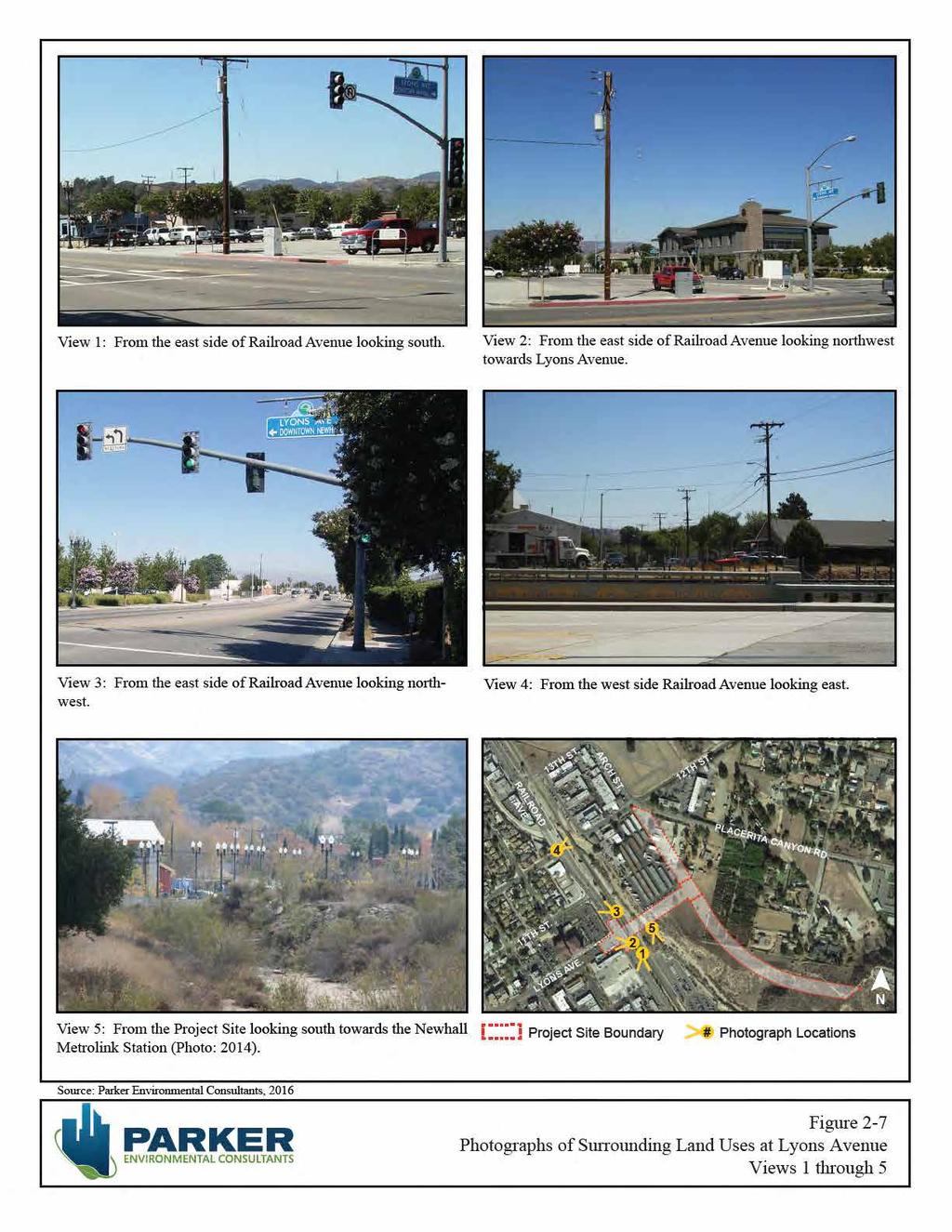
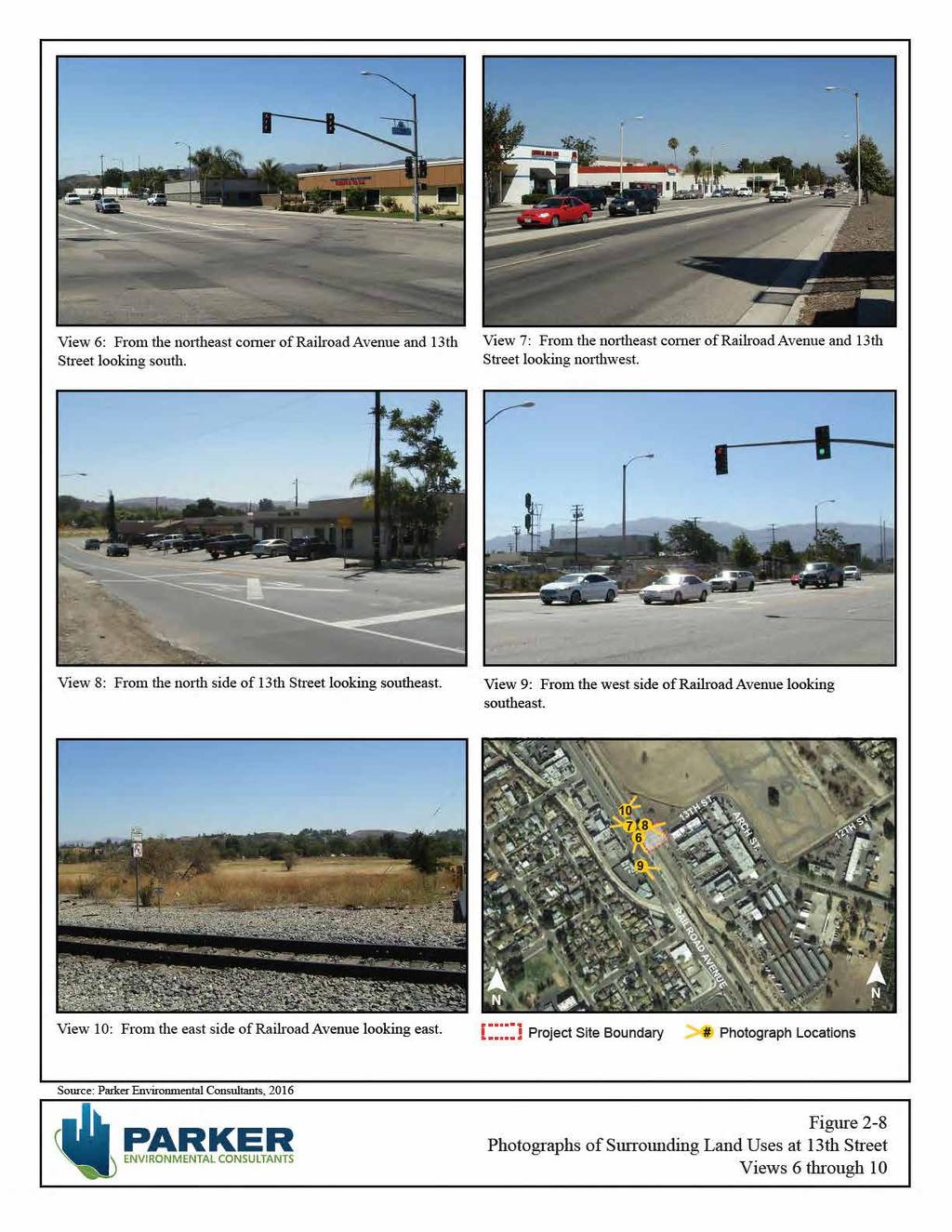
11 City of Santa Clarita August 2017 The Project Site is also located in the Placerita Canyon Special Standards District (PCSSD) and is part of the North Newhall Area (NNA), which includes a Mixed Use Overlay Zone. Chapter 17.39, Section 020, of the Santa Clarita Municipal Code (SCMC) establishes the PCSSD design standards in order to protect, preserve and enhance the secluded, rural and equestrian character of the Placerita Canyon community. Additionally, the PCSSD serves to help mitigate the cumulative impacts of development and ensure reasonable access to public riding and hiking trails. The North Newhall Area was established in order to stimulate development and redevelopment activities in the area north of Old Town Newhall. The SCMC establishes guidelines for the NNA to ensure that it provides buffering, transitional densities and protection for the existing developed areas and not intrude in or change the character of Placerita Canyon. Additionally, a Mixed Use Overlay Zone was adopted to encourage a mix of residential, commercial, employment, and institutional uses along the Newhall Avenue and Lyons Avenue corridors. The Mixed Use Overlay Zone serves to revitalize older commercial corridors, increase opportunities for infill housing, and encourage development that creates pedestrian-oriented neighborhoods. 2.4 SURROUNDING LAND USES The portion of the Project Site to the east of the intersection of Railroad Avenue and Lyons Avenue (across Newhall Creek), is bounded the Old Town Newhall Library and commercial uses to the west, across Railroad Avenue (See Figure 2-7, View 1, 2 and 3), commercial and industrial uses to the north (See Figure 2-7, View 4), the Newhall Metrolink Station to the south (See Figure 2-7, View 5), residential properties to the east and a landscape nursery to the east and southeast. Photographs of existing surrounding land uses at Railroad Avenue and Lyons Avenue are depicted in Figure 2-7, Photographs of Surrounding Land Uses at Lyons Avenue. Photographs of existing surrounding land uses at Railroad Avenue and 13 th Street are depicted in Figures 2-8. The portion of the Project Site to the east of the intersection of Railroad Avenue and 13 th Street is bounded by one-story commercial buildings to the west, across Railroad Avenue (See Figure 2-8, View 6 and 7), industrial and commercial uses to the east (See Figure 2-8, View 8 and 9), undeveloped land to the north (See Figure 2-8, View 10), and Newhall Creek to the south. Properties to the north of the aforementioned portions of the Project Site are zoned MX-N with a General Plan land use designation of Mixed Use - Neighborhood. Properties to the south of this portion of the Project Site are zoned SP with a General Plan land use designation of Specific Plan. Properties to the east of this portion of the Project Site are zoned UR1, UR3 and PI, with a General Plan land use designation of Urban Residential One, Urban Residential Three and Public Institutional, respectively. Properties to the west, across Railroad Avenue are zoned SP with a General Plan land use designation of Specific Plan. Lyons Avenue/Dockweiler Drive Extension Project 2. Project Description SCH No Page 2-11
12
13
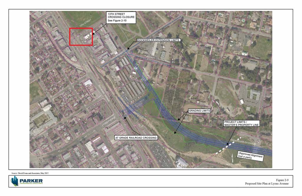
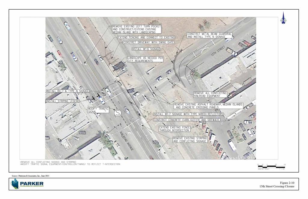
14 City of Santa Clarita August PROJECT CHARACTERISTICS The proposed Lyons Avenue/Dockweiler Drive Extension Project ( Proposed Project ) is a multi-phased project being coordinated by the City of Santa Clarita and The Master s University to improve circulation and access to the Placerita Canyon and Newhall Communities. The Lyons Avenue/Dockweiler Drive extension is proposed to be one of the primary east-west arterials through the City of Santa Clarita that would provide a through connection from Sierra Highway to Railroad Avenue. The Proposed Project includes the extension of Lyons Avenue from Railroad Avenue southeast to the proposed connection with Dockweiler Drive, the addition of a new at-grade railroad crossing east of the Railroad Avenue and Lyons Avenue intersection, and the extension of Dockweiler Drive from the approved alignment of Dockweiler Drive at The Master s University site (The Master s University extension of Dockweiler Drive through The Master s University property was evaluated under a separate EIR 1 ), and northwest to connect with the intersection of Arch Street and 12 th Street. The Proposed Project would extend Lyons Avenue from its existing terminus at Railroad Avenue, eastward to Dockweiler Drive to provide a T-intersection at Dockweiler Drive. The Proposed Site Plan is depicted in Figure 2-9. In coordination with the proposed Railroad Bike Path project, the new Dockweiler Drive extension will result in creating a vital Complete Street link between the communities to the east of the railroad/ Newhall Creek (including the Master s University) and Old Town Newhall and Metrolink station. The Proposed Project also includes the closure of an at-grade railroad crossing at the intersection of 13 th Street and Railroad Avenue. The intersection at 13 th Street would be modified, removing the northbound right turn lane and southbound left turn lane and restricting the eastbound through movement. The Proposed Site Plan for the at-grade railroad closure at 13 th Street and Railroad Avenue is depicted in Figure The Master s College Master Plan Draft EIR, dated July 2008, and Final EIR, dated October SCH No Lyons Avenue/Dockweiler Drive Extension Project 2. Project Description SCH No Page 2-14
15 [Page left intentionally blank.]
16
17
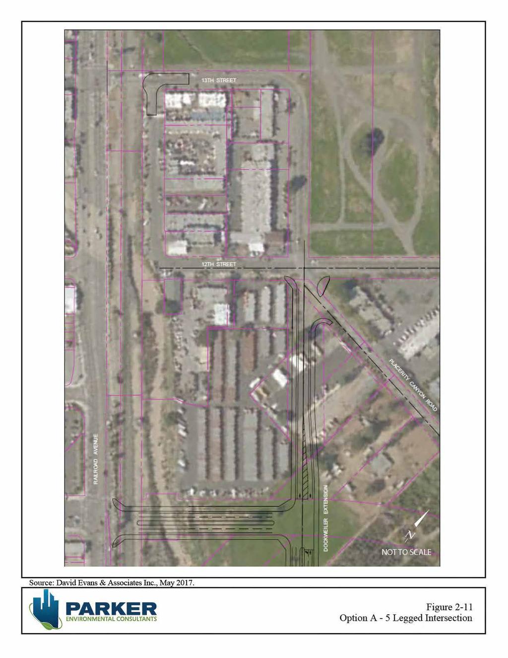
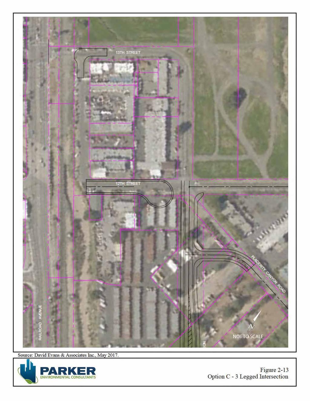
18 City of Santa Clarita August 2017 Design Features The Proposed Project will include re-profiling the intersection of Lyons Avenue and Railroad Avenue to allow the construction of a new SCRRA/UP railroad at-grade crossing east of Railroad Avenue. The proposed at-grade crossing at Lyons Avenue will improve traffic movements and circulation. Roadway construction will include a new bridge crossing over Newhall Creek and would necessitate embankment protection on both sides of the creek. The Newhall Creek improvements will be designed in accordance with current regulatory and State permitting agencies. Street improvements would include: Installation of a new traffic signal at Lyons and Railroad Avenues; Installation of intersection improvements at the Arch Street/12 th Street/Placerita Canyon and proposed Dockweiler Drive alignment. For purposes of this analysis, the following three intersection configurations were evaluated as potential design options: o A 5-way intersection configuration as shown in Figure 2.11: Option A 5-Legged Intersection. o A traffic circle as shown in Figure 2.12: Option B, Traffic Circle. o A 3-legged intersection as shown in Figure 2.13: Option C, 3-Legged Intersection. Street widening for Lyons and Railroad Avenues; Installation of raised median island on both streets; New signing, striping and legends such as monument signage to properly identify the entrance to the Placerita Canyon community as a residential community with no through access. Railroad improvements would include: New railroad signal house; Crossing Panels; Advance Preemption and railroad signal design; Pedestrian gates (4); Railroad related signing, striping and legends; Blank out sign for northbound traffic making right turn into the eastbound Lyons Avenue; New fencing for railroad; New driveway to access railroad property for maintenance; New vehicular gates (6); New railroad loops. The proposed alignment and roadway extension is part of the City s General Plan and consistent with the goals of the Old Town Newhall Specific Plan, Santa Clarita Valley Consolidated Traffic Model (SCVCTM), and the Compass Blueprint Plan. The extension of the proposed roadway (Lyons Avenue) is designated as a Secondary Highway per the City of Santa Clarita s General Plan. This roadway extension Lyons Avenue/Dockweiler Drive Extension Project 2. Project Description SCH No Page 2-17
19
20
21
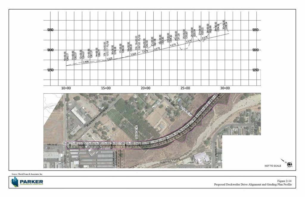
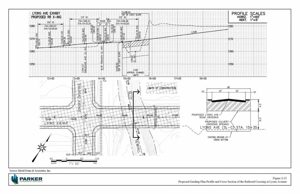
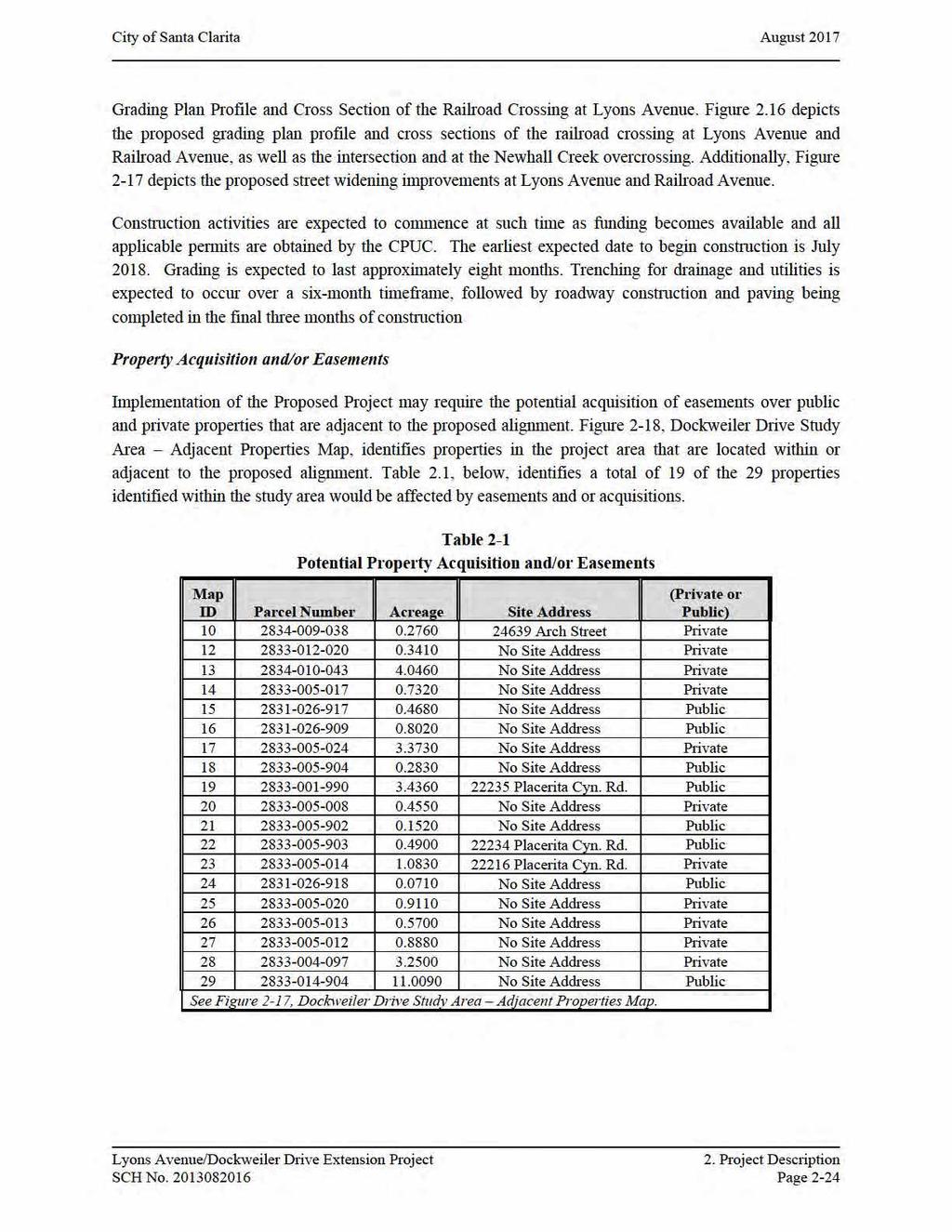
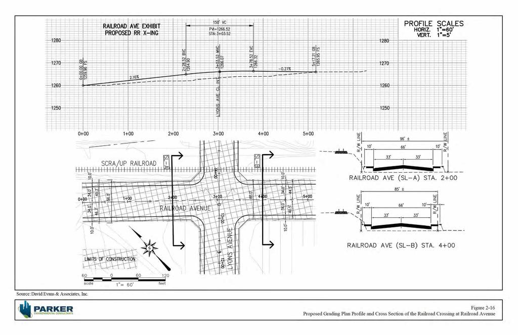
22 City of Santa Clarita August 2017 is consistent with the approved Master s University Master Plan, in which Dockweiler Drive was redesignated as a 4-lane Secondary Highway. The proposed roadway from the Arch Street/12 th Street/Placerita Canyon/Dockweiler Drive intersection to the future intersection of Lyons Avenue and Dockweiler Drive will be a two-lane facility with a 13-foot landscaped parkway/sidewalk on each side. The proposed roadway from the Lyons Avenue and Dockweiler Drive intersection to the Master s University property line will be a 2-lane facility with a 12-foot raised landscaped median, and 13-foot parkway/sidewalk on each side. The median lanes will be 12 feet wide and the parking lanes 9 feet wide with a 6-foot bike lane. The parking lanes will be capable of being converted into a travel lane to create an ultimate 4-lane facility in compliance with the City s General Plan. The typical right-of-way (R/W) width will be 92 feet. The Proposed Project would also include the closure of an at-grade crossing at the intersection of Railroad Avenue and 13 th Street. Street improvements at the 13 th Street and Railroad Avenue at-grade railroad crossing intersection are illustrated in Figure 2.10, 13 th Street Crossing Closure and would include: Modify existing traffic signal for a T-intersection operation Street construction with new curb and gutter and related striping, signing, and legends New landscaping along 13 th Street near railroad property Modify signing, striping and legends on 13 th Street and Railroad Avenue to reflect new intersection and new design for 13 th Street Railroad improvements associated with the closure of the 13 th Street at-grade crossing would include: Remove railroad signal house and modify railroad signal interference with the traffic signal Remove crossing panels Modify railroad signal and related work Remove railroad related signing, striping and legends Remove all railroad related signals in coordination with City s traffic signal New fencing for railroad New driveway to access railroad property for maintenance Construction The construction of the Proposed Project east of Railroad Avenue will join existing roadways in the Placerita Canyon and Newhall communities. Connection points are proposed at the Arch Street/12 th Street intersection, Railroad Avenue and Lyons Avenue, and the proposed Dockweiler Drive extension at The Master s University. See Figures 2.11 through 2.13 for the three optional design configurations for the Arch Street/12 th Street/Placerita Canyon/Dockweiler Drive intersection. The extent of grading and contour of the proposed roadway extension is illustrated in Figure 2-14, Proposed Dockweiler Drive Alignment and Grading Plan Profile. Cross section illustrations of the grading plan profile at the Lyons Avenue railroad at-grade crossing and Newhall Creek overcrossing are shown in Figure 2-15, Proposed Lyons Avenue/Dockweiler Drive Extension Project 2. Project Description SCH No Page 2-21
23
24
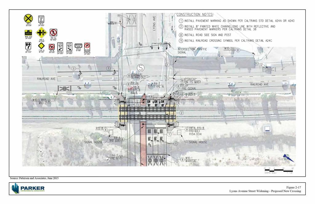
25
26
27
28
29 City of Santa Clarita August PROJECT OBJECTIVES The purpose of the proposed project is to achieve CPUC approval of an at-grade rail crossing at the current terminus of Lyons Avenue and the Southern Pacific Railroad line and extend a through roadway connection from Lyons Avenue to Dockweiler Drive. The Applicant s stated objectives for the proposed project are as follows: Implementation of the goals of the Circulation Element of the Santa Clarita General Plan, including the crossing at Lyons Avenue and the extension of Lyons Avenue/Dockweiler Drive; Improve roadway level of service and circulation network; Provide a safe and efficient at-grade rail crossing that meets the standards of the California Public Utilities Commission (CPUC); Provide sufficient information for CPUC application and approval of the proposed crossing; Improve pedestrian and vehicle railroad safety by eliminating an existing substandard at-grade rail crossing at 13 th Street and replacing it with a more advanced and enhanced at-grade rail crossing at Lyons Avenue; Reduce vehicle miles traveled by creating a more direct route for motorists, eliminating circuitous driving patterns. Provide greater connectivity between Old Town Newhall, Placerita Canyon, The Master s University and the residents that live along Dockweiler Drive; Provide an economic stimulus to Old Town Newhall with enhanced connectivity to the Old Town Newhall area; and Provide an enhanced gateway to Placerita Canyon. 2.7 DISCRETIONARY APPROVALS Lead Agency Under CEQA, the public agency that has the principal responsibility for carrying out or approving a proposed project is referred to as the Lead Agency (State CEQA Guidelines Section 15367). For purposes of the Dockweiler Drive Alignment Project, the City of Santa Clarita is identified as both the project proponent ( Applicant ) and Lead Agency. The proposed project would be part of the City s Capital Improvement Program. The City Council is the City s decision-making body and is responsible for approving projects to be built within City limits. Prior to approving the Proposed Project, the City Council must certify that (1) this EIR has been reviewed and considered; (2) the EIR has adequately analyzed the potential impacts of the proposed project; (3) it has been completed in compliance with CEQA, the State CEQA Guidelines, and the City s Environmental Guidelines; and (4) it reflects the independent judgment of the City Council. The Proposed Project would also require the approval of an Oak Tree Permit and Hillside Review Permit at such time as development occurs or when funding of roadway construction becomes available. In order to allow for the proposed development to occur, the Proposed Project would require an Oak Tree Permit and a Hillside Review Permit. Depending on the approval of the Proposed Project or one of the Project Alternatives evaluated within the scope of the EIR, the oak tree permit would be required to determine the Lyons Avenue/Dockweiler Drive Extension Project 2. Project Description SCH No Page 2-28
30 City of Santa Clarita August 2017 oak tree impacts at the time of project development. The Hillside Review Permit would permit the grading necessary to construct the roadway. These entitlements will be obtained at such time as the proposed alignment is approved and roadway funding is available to implement the Project. Because it is not known at this time when the project would be funded or built and permits expire after two years, it was determined to be more cost effective to wait until such time as construction of the roadway is imminent to secure permits for the project. Additional ministerial actions, such as grading permits, would be required by the City prior to actual grading and construction of the proposed roadway extension. Responsible Agencies Public agencies other than the Lead Agency, that have discretionary approval power or regulatory oversight over the proposed project or project activities are considered Responsible Agencies (State CEQA Guidelines Section 15381). If the City approves the Proposed Project, subsequent implementation of various project components could require discretionary approval authority from the following responsible agencies: California Public Utilities Commission (CPUC); Southern California Rail Authority; Los Angeles County Metropolitan Transportation Authority (LACMTA); California Department of Fish and Wildlife (CDFW); California Regional Water Quality Control Board (RWQCB); Los Angeles County Fire Department (LACFD): Los Angeles County Department of Public Works (LAPW) South Coast Air Quality Management District (SCAQMD); U.S. Fish and Wildlife Service (USFWS); and U.S. Army Corps of Engineers (USACE). Lyons Avenue/Dockweiler Drive Extension Project 2. Project Description SCH No Page 2-29
4. ENVIRONMENTAL IMPACT ANALYSIS 7. LAND USE AND PLANNING
 4. ENVIRONMENTAL IMPACT ANALYSIS 7. LAND USE AND PLANNING 4.7.1 INTRODUCTION The following analysis discusses the consistency of the Proposed Project with the corresponding land use and zoning designations
2. INTRODUCTION 2.1 AUTHORITY 2.2 PURPOSE AND INTENT 2.3 SITE LOCATION
 2. INTRODUCTION 2.1 AUTHORITY The City of Gardena initiated and prepared the Artesia Corridor Specific Plan pursuant to the provisions of California Government Code, Title 7, Division 1, Chapter 3, Article
The transportation system in a community is an
 7 TRANSPORTATION The transportation system in a community is an important factor contributing to the quality of life of the residents. Without a sound transportation system to bring both goods and patrons
NOTICE OF PREPARATION
 NOTICE OF PREPARATION DATE: January 6, 2016 TO: LEAD AGENCY: Responsible Agencies, Organizations, and Interested Parties Contact: Tyler Barrington, Principal Planner Planning Department Community Development
FUTURE LAND USE ELEMENT
 FUTURE LAND USE ELEMENT GOAL I: To create and sustain a great place to live, play, and prosper Objective 1: The City of Ocala shall incorporate the principles and strategies of the Ocala 2035 Vision into
Land Use Amendment in Southwood (Ward 11) at and Elbow Drive SW, LOC
 at and Elbow Drive SW, LOC") 2018 November 15 Page 1 of 10 EXECUTIVE SUMMARY This land use amendment application was submitted by Rick Balbi Architect on 2017 August 31 on behalf of Sable Developments Ltd, and with authorization from
2018 November 15 Page 1 of 10 EXECUTIVE SUMMARY This land use amendment application was submitted by Rick Balbi Architect on 2017 August 31 on behalf of Sable Developments Ltd, and with authorization from
GENERAL PLAN CONSISTENCY ANALYSIS
 GENERAL PLAN CONSISTENCY ANALYSIS Prepared by Planning Staff 10/28/2013 APPLICABLE GOALS, POLICIES AND PROGRAMS FROM the LAND USE CHAPTER Goal LU-1 Policy LU-1.1 Policy LU-1.2 Goal LU-2 Protect the character
CHAPTER 7: Transportation, Mobility and Circulation
 AGLE AREA COMMUNITY Plan CHAPTER 7 CHAPTER 7: Transportation, Mobility and Circulation Transportation, Mobility and Circulation The purpose of the Transportation, Mobility and Circulation Chapter is to
4.1 AESTHETICS AND VISUAL QUALITY
 SCOPE AND METHODOLOGY 4.1 AESTHETICS AND VISUAL QUALITY This section evaluates the potential impacts to aesthetics and visual quality. Aesthetics refers to visual resources and the quality of what can
3. Project Description
 3.1 PROJECT LOCATION The Platinum Triangle (herein after also referred to as the Project Area ) is located at the confluence of the Interstate 5 (I-5 Freeway) and the State Route 57 (SR-57 Freeway), in
NOTICE OF PREPARATION
 NOTICE OF PREPARATION DATE: April 6, 2017 TO: FROM: Responsible Agencies Trustee Agencies Local and Public Agencies Interested Parties Contact: Brent Cooper, AICP, Community Development Director 4381 Broadway
3.1 Aesthetics, Light, and Glare
 3.1 3.1.1 Introduction This section describes the existing aesthetics, light, and glare setting and potential effects from project implementation on visual resources and the site and its surroundings.
LOS ANGELES COUNTY METROPOLITAN TRANSPORTATION AUTHORITY (LACMTA)
") CE OF PREPARAT LOS ANGELES COUNTY METROPOLITAN TRANSPORTATION AUTHORITY (LACMTA) NOTICE OF PREPARATION OF AN ENVIRONMENTAL IMPACT STATEMENT (E1S)lENVIRONMENTAL IMPACT REPORT (EIR) TO: AGENCIES, ORGANIZATIONS
CE OF PREPARAT LOS ANGELES COUNTY METROPOLITAN TRANSPORTATION AUTHORITY (LACMTA) NOTICE OF PREPARATION OF AN ENVIRONMENTAL IMPACT STATEMENT (E1S)lENVIRONMENTAL IMPACT REPORT (EIR) TO: AGENCIES, ORGANIZATIONS
CHARLES PUTMAN CHARLES PUTMAN AND ASSOCIATES, INC
 MEMORANDUM CHARLES PUTMAN & ASSOCIATES, INC. LAND DEVELOPMENT CONSULTANTS PLANNING ZONING PERMITTING 4722 NW Boca Raton Boulevard, Suite C-106 Boca Raton, Florida 33431 Phone: 561/994-6411 FAX: 561/994-0447
4.1 LAND USE AND PLANNING EXISTING CONDITIONS REGULATORY BACKGROUND LAND USES IN THE PLAN AREA SURROUNDING LAND USES
 4.1 LAND USE AND PLANNING This section includes a description of the existing land use plans that apply to the Plan area and a description of existing land uses in the vicinity. It also includes an analysis
NOTICE OF PREPARATION
 NOTICE OF PREPARATION To: All Interested Parties Subject: Notice of Preparation of an Environmental Impact Report From: City of Petaluma Address: 11 English Street, Petaluma, CA 94952-2610 Contact: Heather
1.0 VISION STATEMENT. December 6, PRINCIPLES
 Vision Statement Lincoln Regional Airport 1.0 VISION STATEMENT 1.1 City LOCATION of AND OVERVIEW The Easton Lincoln Place Land Use Master Plan identifies the principles, goals, policies, and standards
DRAFT Civic Center Station Area Plan. Executive Summary
 DRAFT Civic Center Station Area Plan Executive Summary This project is funded in part through the Metropolitan Transportation Commission s Station Area Planning Program. The preparation of this report
3.4.5 Roadway System and Infrastructure Phase I (Project) Roadway System Components E Street Extension (Phase I).
 Roadway System Components E Street Extension (Phase I).") 3.4.5 Roadway System and Infrastructure Roadway demolition, road improvements, roadway realignments, and construction of new roads, as well as utility infrastructure improvements, transit, as well as pedestrian
3.4.5 Roadway System and Infrastructure Roadway demolition, road improvements, roadway realignments, and construction of new roads, as well as utility infrastructure improvements, transit, as well as pedestrian
APPENDIX C SPECIAL PLANNING AREAS
 SPECIAL PLANNING AREAS There are five Special Planning Areas (SPAs) on the Land Use Diagram (Figure LU-2). The SPAs are areas with significant new growth potential that require more detailed subsequent
Hockessin Community Redevelopment Plan
 Hockessin Community Redevelopment Plan 3.1 Introduction The Community Redevelopment Plan for the Village of Hockessin is the result of the people s vision for a distinct village center that serves as the
EXECUTIVE SUMMARY. Introduction
 EXECUTIVE SUMMARY Introduction State Route 68 is a designated scenic route that connects the world-renowned Monterey Peninsula to US Highway 101 and the Salinas Valley. SR 68 is a key route for bicycle,
C. Westerly Creek Village & The Montview Corridor
 C. Westerly Creek Village & The VISION Community Vision When the goals of the city are achieved Westerly Creek Village, a distinctive community defined by Montview Boulevard and Westerly Creek, is a strong
Eastern Terminus TECHNICAL MEMORANDUM CENTRAL BROWARD EAST-WEST TRANSIT ANALYSIS BROWARD COUNTY, FLORIDA
 Eastern Terminus TECHNICAL MEMORANDUM CENTRAL BROWARD EAST-WEST TRANSIT ANALYSIS BROWARD COUNTY, FLORIDA FINANCIAL PROJECT ID NUMBER 411189-2-22-01 FLORIDA DEPARTMENT OF TRANSPORTATION DISTRICT 4 Prepared
Table L-1 Summary Action Strategy. Action Item Timing Status Responsible Agency
 CHAPTER 4: CIRCULATION ELEMENT ISSUE #1: MAJOR THOROUFARES AND TRANSPORTATION ROUTES A balanced transportation system for Fontana is provided that meets the mobility needs of current and future residents
Northwest Rail Corridor and US 36 BRT Development Oriented Transit Analysis 4.4 STATION AREA FINDINGS
 4.4 STATION AREA FINDINGS Each station is different, and each one requires a separate set of recommendations based on the vision for the site. This section outlines an initial TOD strategy and recommendations
Gold Line Bus Rapid Transit Transit Oriented Development (BRTOD) Helmo Station Area Plan
 Helmo Station Area Plan") Appendix F Gold Line Bus Rapid Transit Transit Oriented Development (BRTOD) Helmo Station Area Plan Introduction and Purpose of the Plan The Gold Line Bus Rapid Transit facility is an eleven-mile dedicated
Appendix F Gold Line Bus Rapid Transit Transit Oriented Development (BRTOD) Helmo Station Area Plan Introduction and Purpose of the Plan The Gold Line Bus Rapid Transit facility is an eleven-mile dedicated
Seneca Meadows. Block 4 Locate office, technology, and medical development adjacent to I Screen views of garage structures from I-270.
 Seneca Meadows Seneca Meadows has an industrial park in its southern end and a mixed-use employment area planned for the north end. The district benefits from extensive I-270 visibility, stream valley
I. INTRODUCTION. Project Background and Study Area
 I. INTRODUCTION Project Background and Study Area Freedom Parkway is a key east-west corridor connecting I-25 on the west to the Town of Kersey on the east, running approximately one to two miles south
MASTER PLAN. 201 Planning Concepts. Chapter 2
 Chapter 2 MASTER PLAN 201 Planning Concepts 202 Master Land Use Plan 203 Affordable Housing Program 204 Parks, Open Space, and Recreation Trails 205 Grading Concept 206 Circulation Plan 207 Landscape Concept
Existing Transportation System 5-1
 5-1 The Jackson County transportation system is served by several modes of transportation including streets and highways, multi-modal, non-motorized, rail, and aviation. While the focus of the transportation
3.0 Project Description
 3.0 Project Description 3.0 PROJECT DESCRIPTION 3.1 PROJECT LOCATION AND SETTING PROJECT LOCATION The proposed Downtown Lancaster Specific Plan Project (project) is located in the City of Lancaster, California.
Strategic Growth Area #1 Northampton Boulevard Corridor Area
 Strategic Growth Area #1 Northampton Boulevard Corridor Area Description Strategic Growth Area #1 has established itself as a major employment center in Southside Hampton Roads. Opportunities exist to
Appendix A: Notice of Preparation and Responses
 City of American Canyon Broadway District Specific Plan Draft EIR Appendix A: Notice of Preparation and Responses FirstCarbon Solutions \\10.200.1.5\adec\Publications\Client (PN JN)\3148\31480009\EIR\2
INFRASTRUCTURE EXISTING INFRASTRUCTURE A. Circulation B. Signals C. Drainage D. Utilities
 7.01. EXISTING INFRASTRUCTURE A. Circulation B. Signals C. Drainage D. Utilities 7.02. PROPOSED INFRASTRUCTURE A. Overall Concept B. Circulation C. Signals D. Drainage 7.03. INFRASTRUCTURE MAP A. Key Infrastructure
3. VISION AND GOALS. Vision Statement. Goals, Objectives and Policies
 Vision Statement Queen Creek s interconnected network of parks, trails, open spaces and recreation opportunities provide safe and diverse activities and programs that sustain its unique, small town, equestrian
Town Center (part of the Comprehensive Plan)
") Town Center (part of the Comprehensive Plan) Mercer Island Town Center Looking North (2014) In 1994, a year-long process culminated in a set of design guidelines and code requirements for the Town Center
Town Center (part of the Comprehensive Plan) Mercer Island Town Center Looking North (2014) In 1994, a year-long process culminated in a set of design guidelines and code requirements for the Town Center
PROJECT DESCRIPTION ENVIRONMENTAL SETTING. Project Site Location FIGURE 1 - REGIONAL LOCATION MAP
 PROJECT DESCRIPTION ENVIRONMENTAL SETTING Project Site Location The proposed project site is located within the City of Camarillo in Ventura County. As shown in Figure 1, the City of Camarillo is located
Venice Pumping Plant Dual Force Main Project Draft EIR
 City of Los Angeles 5.9 LAND USE PLANS 5.9.1 Environmental Setting Venice Pumping Plant Dual Force Main Project Draft EIR The Project lies within the bounds of Los Angeles County and the City of Los Angeles.
2.0 AREA PLANS. Lakeside Business District. Lakeside Business District Land Use Categories:
 Lakeside Business District Lakeside Business District Land Use Categories: Campus Commercial Campus Commercial means a mixture of uses which includes corporate offices, office parks, hotels, commercial,
Department of Community Development. Planning and Environmental Review Division Revised Notice of Preparation
 Department of Community Development Michael J. Penrose, Acting Director Divisions Building Permits & Inspection Code Enforcement County Engineering Economic Development & Marketing Planning & Environmental
Today Land & People. Northeast Nampa Gateway District. Employment. Land Use Characteristics. Demographics. Current Zoning
 Today Land & People Employment Major employers include Saint Alphonsus, the College of Western Idaho, the Auto Mall, Sorrento Lactalis and Walmart. 3,004 jobs in 2010 (COMPASS-CIM 2040 TAZ data) 4,345
3.0 PROJECT DESCRIPTION
 3.0 PROJECT DESCRIPTION 3.1 BACKGROUND Under California law (Government Code Section 65300 et seq.), every city and county is required to have a general plan. The general plan is to be comprehensive and
SPRINGHILL LAKE TRANSIT VILLAGE
 Greenbelt Metro Area Sector Plan - Subarea Design Policies and Guidelines - Springhill Lake Transit Village 113 SPRINGHILL LAKE TRANSIT VILLAGE Residential Neighborhood and Village Center CONCEPT Springhill
3.10 LAND USE SETTING PROJECT SITE EXISTING LAND USE DESIGNATIONS AND ZONING. General Plan Land Use Designations.
 This section of the Draft EIR addresses the existing land uses on and adjacent to the project site and discusses the potential impacts of the proposed project on existing land uses. Key issues addressed
Staff Report CONDITIONAL USE
 Staff Report PLANNING DIVISION COMMUNITY & ECONOMIC DEVELOPMENT To: From: Salt Lake City Planning Commission Daniel Echeverria, (801) 535-7165, daniel.echeverria@slcgov.com Date: May 21, 2015 Re: PLNPCM2015-00139
Blue Line LRT Extension
 v e Noble Pkwy Noble Pkwy Xerxes Ave N Shingle Creek Penn Ave N Penn Ave N Fremont Ave N Lyndale Ave N S Washington Ave University Ave NE Blue Line LRT Extension LIGHT RAIL PLATFORM AND STATION DESIGN
Ten Mile Creek Planning Area
 PLANNING AREA POLICIES TEN MILE CREEK Ten Mile Creek Planning Area Location and Context The Ten Mile Creek Planning Area ( Ten Mile Creek area ) is located south of the current Boise AOCI, generally south
A P P E N D I X B - O P P O R T U N I T Y S I T E S
 A P P E N D I X B - O P P O R T U N I T Y S I T E S OPPORTUNITY SITES As listed in the Land Use Element, the City has identified 15 Opportunity Sites expected to be the focus of change and revitalization
ITEM #8. Regional Smart Growth Program. Regional Smart Growth Program. Presentation Overview. Coast Highway Vision and Stategic Plan.
 Regional Smart Growth Program Economic Development Commission What is Smart Growth? Adopted as part of the Regional Comprehensive Plan (RCP) RCP provides vision for region based on Smart Growth and sustainability
Definitions. Average Daily Traffic Demand (ADT): The actual number or projected number of cars that pass a point in a 24-hour period.
: The actual number or projected number of cars that pass a point in a 24-hour period.") Definitions Access Management: A combination of physical techniques and transportation policies used to control the flow of traffic between roads and the surrounding lands. Alternative City Form Scenarios:
Definitions Access Management: A combination of physical techniques and transportation policies used to control the flow of traffic between roads and the surrounding lands. Alternative City Form Scenarios:
CHAPTER 3 VISION, GOALS, & PLANNING PRINCIPLES. City of Greensburg Comprehensive Plan. Introduction. Vision Statement. Growth Management Goals.
 CHAPTER 3 VISION, GOALS, & PLANNING PRINCIPLES Introduction The Greensburg Comprehensive Plan is intended as a working community document. A combination of long and short-term goals, this document is intended
The impacts examined herein take into account two attributes of aesthetic values:
 IV. ENVIRONMENTAL IMPACT ANALYSIS This section addresses the potential impacts to views and aesthetics as a result of the proposed Project at the Project Site and the development scenarios analyzed for
CHAPTER 5 Public Realm Improvements
 5.1 OVERVIEW This chapter focuses on the public realm, that is, spaces within and directly adjacent to public rights-of-way (ROWs), including streets, Oso Creek, the rail corridor, and the freeway edge.
APPENDIX D: Visual and Aesthetic Conditions for NCCU Station Refinement. Durham-Orange Light Rail Transit Project
 APPENDIX D: Visual and Aesthetic Conditions for NCCU Station Refinement Durham-Orange Light Rail Transit Project October 2016 1. Introduction The Combined FEIS/ROD summarizes the effects of the D-O LRT
LAND USE DESIGNATIONS AND ZONING CLASSIFICATIONS
 LAND USE DESIGNATIONS AND ZONING CLASSIFICATIONS One of the most significant issues addressed within the community plan process is land use. How land is utilized within a community directly affects the
Pine Island Road Corridor Master Plan
 RECOMMENDED DEVELOPMENT PLAN Figure 9: Del Prado Village District Conceptual Framework The Conceptual Framework (Figure 8) for development of the Pine Island Corridor is to encourage mixed-use development
Land Use. Hardware Street Vendor Mixed-Use
 Land Use Definition Land Use is the way a piece of real estate is utilized. Existing, proposed, and adopted land uses all play a role in the planning process. Once a land use plan is adopted, the next
Lyons Avenue/Dockweiler Drive Extension Project Final Environmental Impact Report
 Lyons Avenue/Dockweiler Drive Extension Project Final Environmental Impact Report Lead Agency: City of Santa Clarita 23920 Valencia Blvd., Ste. 302 Santa Clarita, CA 91355 Contact: Carla Callahan, Senior
Public input has been an important part of the plan development process.
 Lakewood s Comprehensive Plan recognizes that transportation helps shape the community, and that the way the community provides for the safe and efficient movement of people affects the character of the
Urban Development Areas James City County
 24 Urban Development Areas James City County UDA Needs Profile: Anderson s Corner James City County has designated 11 UDAs within its boundaries, and the Anderson s Corner Mixed Use Area is located along
Planning Districts INTRODUCTION
 INTRODUCTION To facilitate detailed examination of development prospects for all areas of the community, Delano has been divided into 14 planning districts. The location of these planning districts is
Carlsbad Village Redevelopment Concept Summary of Features
 Carlsbad Village Redevelopment Concept Summary of Features Calthorpe Associates November 5, 2003 The Redevelopment Concept illustrates a vision for the future of Carlsbad Village. The overall vision of
RESOLUTION NO. R Refining the route, profile and stations for the Downtown Redmond Link Extension
 RESOLUTION NO. R2018-32 Refining the route, profile and stations for the Downtown Redmond Link Extension MEETING: DATE: TYPE OF ACTION: STAFF CONTACT: Capital Committee Board PROPOSED ACTION 09/13/2018
Section 3.0 Project Description
 Section 3.0 Project Description 3.0 PROJECT DESCRIPTION 3.1 PROJECT LOCATION AND SETTING PROJECT LOCATION Regionally, the Old Town Yucca Valley Specific Plan Area (SPA) is located near the western end
OVOV Consistency Analysis
 OVOV Consistency Analysis Land Use Goals and Policies Urban Form Goal LU 1: Interconnected Valley of Villages providing diverse lifestyles, surrounded by a greenbelt of natural open space. Policy LU 1.1.1:
SUBJECT: PREDEVELOPMENT PLAN REVIEW OF PROJECT LOCATED AT 2632 EAST WASHINGTON BOULEVARD ('ST. LUKE MEDICAL CENTER')
") TO: FROM: Honorable Mayor and City Council Planning & Community Development Department SUBJECT: PREDEVELOPMENT PLAN REVIEW OF PROJECT LOCATED AT 2632 EAST WASHINGTON BOULEVARD ('ST. LUKE MEDICAL CENTER')
TO: FROM: Honorable Mayor and City Council Planning & Community Development Department SUBJECT: PREDEVELOPMENT PLAN REVIEW OF PROJECT LOCATED AT 2632 EAST WASHINGTON BOULEVARD ('ST. LUKE MEDICAL CENTER')
Appendix I-A3 DENAIR COMMUNITY PLAN
 Appendix I-A3 DENAIR COMMUNITY PLAN Adopted by the Stanislaus County Board of Supervisors DECEMBER 15, 1998* *A technical update removing reference to the former Stanislaus County Redevelopment Agency
SECTION 2.0 INTRODUCTION
 SECTION 2.0 INTRODUCTION 2.1 PURPOSE AND SCOPE OF THE EIR Environmental Impact Reports (EIR) are informational documents which wil inform public agency decision-makers and the public generally of the significant
MAIN STREET ECONOMIC DEVELOPMENT STRATEGY
 MAIN STREET ECONOMIC DEVELOPMENT STRATEGY A PATHWAY TO A BETTER POUGHKEEPSIE DRAFT Working Paper #2: Planning Strategies Submitted December 1 st, 2015 to the City of Poughkeepsie LAND USE LAW CENTER PACE
Olde Towne Vision Plan
 Olde Towne Vision Plan Introduction In 2016, the City of Bellevue will complete its move of City offices from Olde Towne Bellevue to its new municipal complex on Wall Street. The City intends to sell its
Notice of Preparation of an Environmental Impact Report and Scoping Meeting for the Canyon Lane Roadway Improvements Development Project
 of an Environmental Impact Report and Scoping Meeting for the As the Lead Agency, the County of San Mateo (County) will prepare an Environmental Impact Report (EIR) for the (project), and would like your
CHAPTER 7: VISION AND ACTION STATEMENTS. Noble 2025 Vision Statement
 CHAPTER 7: VISION AND ACTION STATEMENTS This chapter presents the vision, policy and action statements that transform the comprehensive planning study, an analysis of Noble s past, future trends and community
East Corridor Final Environmental Impact Statement
 East Corridor Final Environmental Impact Statement Alternatives Considered Operating Plan The requirements for opening day operations versus year 2030 are based on ridership and operations. Opening day
THE 355/270 CORRIDOR:
 THE 355/270 CORRIDOR: Strategic Ideas for Sustaining a Livable Work Place Project Summary ACCESS LIFE DESIGN HEALTH WORK Montgomery County Planning Department The Maryland-National Capital Park and Planning
III. PROJECT DESCRIPTION
 III. PROJECT DESCRIPTION LOCATION AND BOUNDARIES The City of Manhattan Beach is located in the South Bay region of Los Angeles County, California, approximately 2 miles south of the Los Angeles International
2.0 PROJECT DESCRIPTION
 2.0 PROJECT DESCRIPTION The proposed project involves the redevelopment of an approximately 6.3-acre site in the City of Long Beach with a mixed-use village center project. This section describes the project
4.8 LAND USE AND PLANNING
 4.8 LAND USE AND PLANNING 4.8.1 INTRODUCTION This section describes existing and planned land uses at the Hayward campus and analyzes the impact of implementation of the proposed Master Plan on land uses
CHAPTER 10-D GREATER MONTEREY PENINSULA AREA PLAN
 CHAPTER 10-D GREATER MONTEREY PENINSULA AREA PLAN GREATER MONTEREY PENINSULA AREA PLAN SUPPLEMENTAL POLICIES 1.0 - Land Use GMP-1.1 GMP-1.2 GMP-1.3 GMP-1.4 GMP-1.5 GMP-1.6 GMP-1.7 The County shall overlay
Draft Memorandum #1: Goals and Vision for Revitalization
 Keizer Revitalization Plan Draft Memorandum #1: Goals and Vision for Revitalization Submitted to: City of Keizer April 12, 2018 (revised) Prepared By: Angelo Planning Group and Otak, Inc. Project No. 17482.A
Land Use and Transportation Plan
 5 Land Use & Transportation Plan Figure 5.1 Construction at I 10 on ramp Land Use and Transportation Plan The Land Use and Transportation Plan represents the preferred land use, physical form, and circulation
REGIONAL ACTIVITY CENTER
 DRAFT REGIONAL ACTIVITY CENTER 70 EAST BENCH MASTER PLAN DRAFT 06 Introduction The East Bench Regional Activity center is comprised of large educational, research, medical, and employment centers. These
THE PLANNING AREA 2.1 PLANNING AREA LOCATION
 2. The Planning Area Brisbane Baylands Specific Plan 21 2 THE PLANNING AREA 2.1 PLANNING AREA LOCATION The Baylands is located approximately midway between San Francisco s central business district and
ADOPTED CAPITAL IMPROVEMENT PROGRAM BUDGET ARROYO PROJECTS
 ADOPTED CAPITAL IMPROVEMENT PROGRAM BUDGET ARROYO PROJECTS HAHAMONGNA FY 212-216 Capital Improvement Program Priority Description Total Estimated Costs Appropriated Through FY 211 Adopted FY 212 FY 213
9IMPLEMENTATION AND PHASING
 9IMPLEMENTATION AND PHASING Purpose A key objective of the Railyard Master Plan is the integration of the public and private realm to provide a network of places that connect to and complement Commercial
CHAPTER 4: LAND USE & TRANSPORTATION PLAN
 CHAPTER 4: LAND USE & TRANSPORTATION PLAN Insert picture of Goodyear An awesome quote from someone saying something cool about Goodyear goes here. Katie Wilken, Goodyear Planner Land Use and Transportation
III. ENVIRONMENTAL SETTING
 III. ENVIRONMENTAL SETTING A. OVERVIEW OF ENVIRONMENTAL SETTING Regional Setting The project site is located in Los Angeles County in the northeastern San Fernando Valley, approximately 18 miles north
CHAPTER 1. Ms. Guajardo s Class - Central Elementary CH 1 1
 INTRODUCTION CHAPTER 1 Ms. Guajardo s Class - Central Elementary CH 1 1 1.1 SETTING South Centre City is a linear corridor south of Downtown Escondido paralleling Centre City Parkway and South Escondido
5. Environmental Analysis
 5.1 This section of the Draft Environmental Impact Report (DEIR) describes the existing landform and aesthetic character of the project area and discusses the potential impacts to the visual character
UNIVERSITY OF CALIFORNIA, SAN DIEGO
 UNIVERSITY OF CALIFORNIA, SAN DIEGO BERKELEY DAVIS IRVINE LOS ANGELES MERCED RIVERSIDE SAN DIEGO SAN FRANCISCO SANTA BARBARA SANTA CRUZ CAMPUS PLANNING 9500 GILMAN DRIVE # 0074 TEL: (858) 534 6515 LA JOLLA,
Section 1. Executive Summary
 Executive Summary (This page left blank intentionally) Executive Summary Background Economic growth in southern Leavenworth County over the past decade has been strong. As both the number of business and
Clairtrell Area Context Plan
 Clairtrell Area Context Plan March 2005 Urban Development Services City Planning Contents 1. Introduction... 4 2. Development Structure... 6 2.1 Streets... 7 2.1.1 Sheppard Avenue and Bayview Avenue...
4.1 Build Alternative 1 Construction Phasing
 SECTION 4 Implementation Plan This section discusses potential segmentation of the build alternatives into multiple projects for implementation of improvements to the NSH from Rabbit Creek Road to 36th
ARROYO PROJECTS ADOPTED CAPITAL IMPROVEMENT PROGRAM BUDGET
 A RROYO P ROJECTS ADOPTED CAPITAL IMPROVEMENT PROGRAM BUDGET FISCAL YEARS 214-218 HAHAMONGNA Priority Description 1 Hahamongna Watershed Park - Implement Master Plan 211,6 211,6 (77565) 2 Hahamongna -
Corridor Vision. 1Pursue Minnehaha-Hiawatha Community Works Project. Mission of Hennepin County Community Works Program
 1Pursue Minnehaha-Hiawatha Community Works Project Minnehaha-Hiawatha Community Works is a project within the Hennepin Community Works (HCW) program. The mission of the HCW program is to enhance how the
RESOLUTION NO R
 e e RESOLUTION NO R04 0054 BE IT RESOLVED by the Mayor and City Council ofthe City ofpapillion that The Papillion Comprehensive Plan is hereby amended to incorporate the Option A Future Land Use Map Transportation
LAND USE ELEMENT. Purpose. General Goals & Policies
 LAND USE ELEMENT Purpose This Land Use Element contains the goals and policies necessary to support the City s responsibility for managing land resources and guiding development through implementing regulations,
SAN RAFAEL GENERAL PLAN 2040 INTRODUCTION AND OVERVIEW
 SAN RAFAEL GENERAL PLAN 2040 INTRODUCTION AND OVERVIEW Steering Committee Presentation February 14, 2018 Purpose of General Plan Guide land use and development decisions Coordinate transportation, infrastructure,
3.0 LAND USE PLAN. 3.1 Regional Location. 3.2 Existing Conditions Existing Uses. Exhibit Regional Location Map
 3.0 LAND USE PLAN 3.1 Regional Location The Anaheim Resort Specific Plan (ARSP) area is located in the City of Anaheim, which is 35 miles southeast of downtown Los Angeles and 7 miles northwest of Santa
ENVIRONMENTAL SETTING
 II. ENVIRONMENTAL SETTING EXISTING CONDITIONS The 208.87-acre Project site is located in the western portion of the City (refer to Figures II-1 and II-2). The Project site comprises Assessor s Parcel Number