SUBDIVISION PLANNED UNIT DEVELOPMENT & REZONING STAFF REPORT Date: May 5, 2016
|
|
|
- Stella Blair
- 5 years ago
- Views:
Transcription
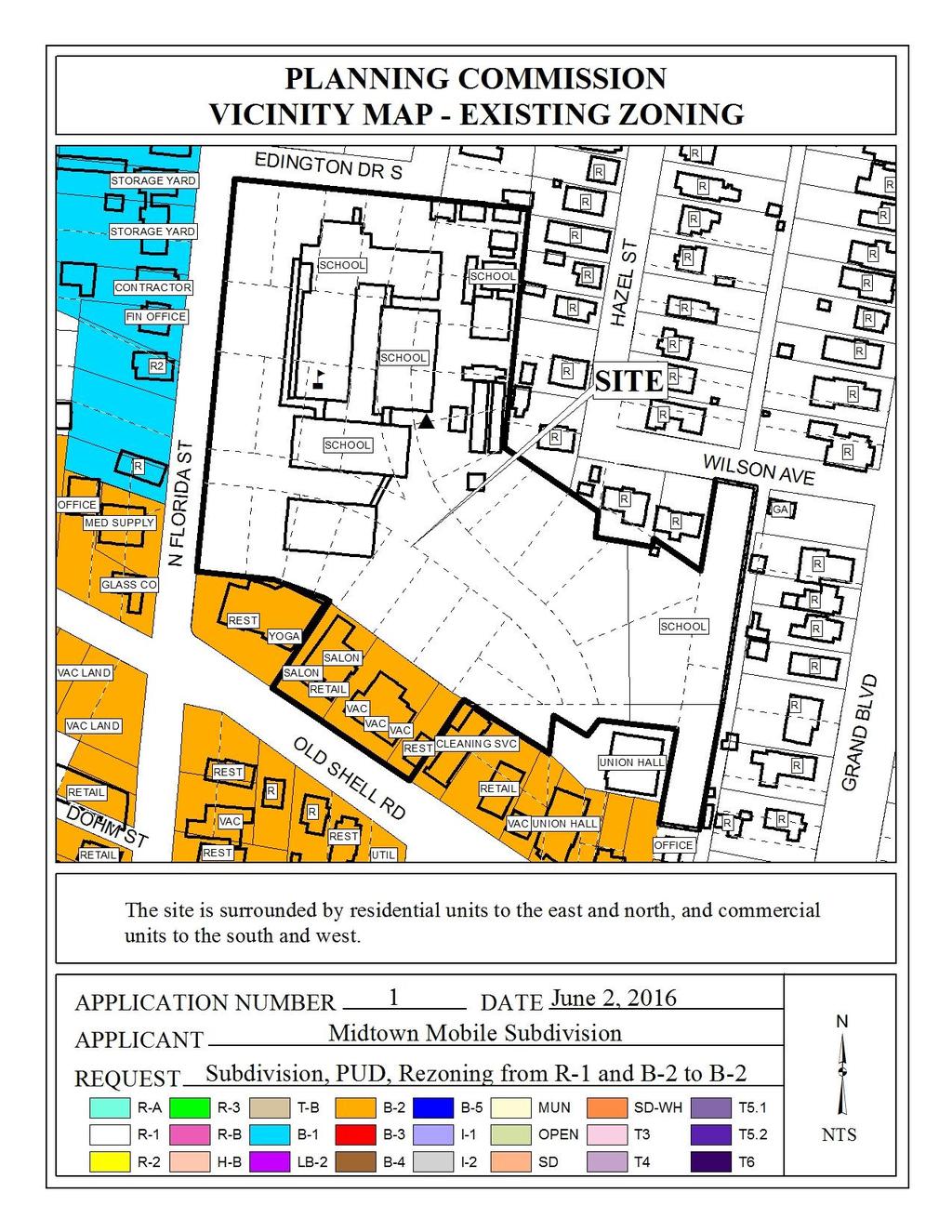
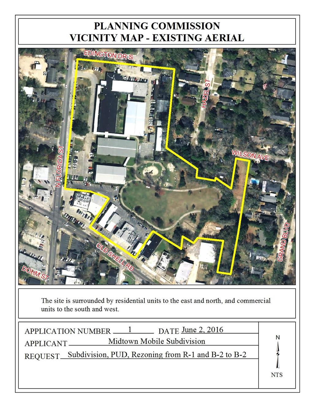
1 SUBDIVISION PLANNED UNIT DEVELOPMENT & REZONING STAFF REPORT Date: May 5, 2016 DEVELOPMENT NAME LOCATION LOCATION Midtown Mobile Subdivision IRC-Mobile Midtown, LLC 100 North Florida Street & 2518, 2524, 2534, 2536 and 2540 Old Shell Road (Northeast corner of North Florida Street and Old Shell Road, extending to the North side of Eddington Drive South). CITY COUNCIL DISTRICT District 1 PRESENT ZONING AREA OF PROPERTY CONTEMPLATED USE TIME SCHEDULE FOR DEVELOPMENT R-1, Single-Family Residential and B-2, Neighborhood Business Subdivision: 2 Lots / Acres PUD: Acres Rezoning: Acres Subdivision Approval to create two legal lots of record. Planned Unit Development (PUD) Approval to multiple building on a single building site and shared access and parking with a separate building site. Rezoning from R-1, Single-Family Residential and B-2, Neighborhood Business, to allow retail development. The Subdivision Regulations require subdivision approval to reconfigure property lines and create legal lots of record. The Zoning Ordinance requires PUD approval to allow multiple buildings on a single building site and shared access between multiple lots; and a minimum of B-2 zoning for retail development. It should be noted, however, that any use permitted in the proposed district would be allowed at this location if the zoning is changed. Furthermore, the Planning Commission may consider zoning classifications other than that sought by the applicant for this property. Immediate
2 ENGINEERING COMMENTS Subdivision The following comments should be addressed prior to submitting the FINAL PLAT for acceptance and signature by the City Engineer: A. Provide all of the required information on the SUBDIVISION PLAT (i.e. signature blocks, signatures, certification statements, written legal description, required notes, legend, scale, bearings and distances) that is required by the current Alabama State Board of Licensure for Professional Engineers and Land Surveyors. B. Provide a signature and seal from a surveyor that is licensed in Alabama not Georgia. C. Provide a legend. D. Correct S Edington Drive to Edington Drive South in the vicinity map, plan sheet, and written legal description. E. Dedicate the corner radius (25 minimum or as approved by the City Engineer and Traffic Engineer) at the northwest corner of LOT 1 (Florida St and Edington Dr. S.). F. Label beginning point as POB to match the written legal description. G. Show and label Jackson Place, Lot 12 that is referred to in the written Legal Description. H. Show and label each and every Right-Of-Way and their width, including Edington Drive and Hazel Street. Show the ROW width of Old Shell Rd at the two (2) corners of LOT 1 that are adjacent to Old Shell Rd. I. Add a signature block for the Owner, Notary Public, Planning Commission, Traffic Engineer, and City Engineer. J. Provide the Surveyor s Certificate and Signature. K. Provide the Surveyor s, Owner s (notarized), Planning Commission, and Traffic Engineering signatures. L. Show and label any proposed easements (drainage, utility, access, etc.). M. Add a note to the SUBDIVISION PLAT stating that a Land Disturbance permit will be required for any land disturbing activity in accordance with Mobile City Code, Chapter 17, Storm Water Management and Flood Control); the City of Mobile, Alabama Flood Plain Management Plan (1984); and, the Rules For Erosion and Sedimentation Control and Storm Water Runoff Control. N. Add a note to the SUBDIVISION PLAT stating that as shown on the 1984 aerial photo (FLIGHT 26 - #77) the Lot(s) will receive historical credit of impervious area towards stormwater detention requirement per Mobile City Code, Chapter 17, Storm Water Management and Flood Control). O. Add a note to the Plat stating that the approval of all applicable federal, state, and local agencies (including all storm water runoff, wetland and floodplain requirements) will be required prior to the issuance of a Land Disturbance permit. P. Add a note that sidewalk is required to be constructed, and/or repaired, along the frontage of each lot, or parcel, at time of new development or construction, unless a sidewalk waiver is approved. Q. Provide a copy of the FINAL PLAT to the Engineering Dept. for FINAL PLAT review prior to obtaining any signatures. R. After the Engineering Dept. Final Plat review is complete, provide a copy of the revised Final Plat along with the original when submitting for City Engineer signature
3 Due to the proposed development on LOT 1 the proposed structures will need to be addressed. Please contact the Engineering Department ( ) to discuss the options prior to submitting any building, land disturbance, or ROW permits. Planned Unit Development ADD THE FOLLOWING NOTES TO THE PUD SITE PLAN: 1. Any work performed in the existing ROW (right-of-way) such as driveways, sidewalks, utility connections, grading, drainage, irrigation, or landscaping will require a ROW permit from the City of Mobile Engineering Department ( ) and must comply with the City of Mobile Right-of-Way Construction and Administration Ordinance (Mobile City Code, Chapter 57, Article VIII). 2. A Land Disturbance Permit application shall be submitted for any proposed land disturbing activity with the property. A complete set of construction plans including, but not limited to, drainage, utilities, grading, storm water detention systems, paving, and all above ground structures, will need to be included with the Land Disturbance permit. This Permit must be submitted, approved, and issued prior to beginning any of the construction work. 3. Any and all proposed land disturbing activity within the property will need to be submitted for review and be in conformance with Mobile City Code, Chapter 17, Storm Water Management and Flood Control); the City of Mobile, Alabama Flood Plain Management Plan (1984); and, the Rules For Erosion and Sedimentation Control and Storm Water Runoff Control. 4. The approval of all applicable federal, state, and local agencies (including all storm water runoff, wetland and floodplain requirements) will be required prior to the issuance of a Land Disturbance permit. The Owner/Developer is responsible for acquiring all of the necessary permits and approvals. 5. The proposed development must comply with all Engineering Department design requirements and Policy Letters. 6. This project will require a perpetual maintenance agreement for the proposed onsite detention/retention system. This agreement must be reviewed, approved, and recorded for the onsite system and include the outfall structure and the pipes that connect to the City maintained drainage system. Revised Engineering PUD comments for the June 2nd meeting: 1. Due to the proposed development on LOT 1 the proposed structures will need to be addressed. Please contact the Engineering Department ( ) to discuss the options prior to submitting any building, land disturbance, or ROW permits. 2. Show and label the proposed improvements on Florida St. and Old Shell Rd. (i.e. widening to 3 lanes, add/extend turn lane) and a note that the improvements will be as approved by the City Engineer and Traffic Engineer. ADD THE FOLLOWING NOTES TO THE PUD SITE PLAN: 1. Any work performed in the existing ROW (right-of-way) such as driveways, sidewalks, utility connections, grading, drainage, irrigation, or landscaping will require a ROW permit from the City of Mobile Engineering Department ( ) - 3 -
4 and must comply with the City of Mobile Right-of-Way Construction and Administration Ordinance (Mobile City Code, Chapter 57, Article VIII). 2. A Land Disturbance Permit application shall be submitted for any proposed land disturbing activity with the property. A complete set of construction plans including, but not limited to, drainage, utilities, grading, storm water detention systems, paving, and all above ground structures, will need to be included with the Land Disturbance permit. This Permit must be submitted, approved, and issued prior to beginning any of the construction work. 3. This project will require that a perpetual maintenance agreement be reviewed, approved, and recorded for the onsite detention/retention system, including the outfall structure and pipes that connect to the City maintained drainage system 4. Any and all proposed land disturbing activity within the property will need to be submitted for review and be in conformance with Mobile City Code, Chapter 17, Storm Water Management and Flood Control); the City of Mobile, Alabama Flood Plain Management Plan (1984); and, the Rules For Erosion and Sedimentation Control and Storm Water Runoff Control. 5. The approval of all applicable federal, state, and local agencies (including all storm water runoff, wetland and floodplain requirements) will be required prior to the issuance of a Land Disturbance permit. The Owner/Developer is responsible for acquiring all of the necessary permits and approvals. 6. The proposed development must comply with all Engineering Department design requirements and Policy Letters. TRAFFIC ENGINEERING COMMENTS A traffic impact study was completed for this site. The development intensity illustrated on the PUD plan is approximately 2,000 SF less than the intensity accounted for in the study. The site plan has also been revised to reduce the number of driveways on Old Shell Road. The reduced square footage would generate the approximate number of trips assumed to use the second driveway on Old Shell Road; therefore an updated study is not required for these changes. Development is contingent upon the completion of offsite improvements as indicated in the study. Recommendations from the Traffic Impact Study include widening the roadway for the inclusion of turn lanes. Any improvement in City of Mobile right-of-way included with the development must meet AASHTO Standards and be approved by City of Mobile Engineering and Traffic Engineering staff. Adequate dedication should be included on any street right-of-way to allow for 11 travel lanes as well as utility/green/sidewalk area. Corner radii dedication should be required at North Florida Street and Edington Drive. Lot 1 is limited to two curb cuts to North Florida Street, limited to one curb cut to Old Shell Road, and denied access to South Edington Drive. Lot 2 is limited to one curb cut to Wilson Avenue. Driveway size, location and design to be approved by Traffic Engineering and conform to AASHTO standards. Required on-site parking, including ADA handicap spaces, shall meet the minimum standards as defined in Section 64-6 of the City s Zoning Ordinance. Angled parking will not be permitted that backs into or is within the right-ofway. If on-street parking is permitted it should be parallel and located within the right-of-way. The traffic impact study may need to be updated if on-street parking is permitted, to analyze the impacts the on-street parking will have on the roadway level of service. Owner/developer will be responsible for obtaining consent from the adjacent land owner(s) on Old Shell Road for any - 4 -
5 site improvements (e.g. driveway radius) that extend in front of the adjacent property frontage. The proposed drive-thru on the south side of Shops A-1 is not desirable as currently shown, as traffic in the middle has vehicles opposing it on both sides. Drive-thru widths must be a minimum of 9 per Section 64-4 of the City s Zoning Ordinance. For Shops A-1 and Shops B, this leaves only 21 for two-way traffic. Aisles can be designated one-way, provided they met width requirements for fire truck access where necessary. Revised Traffic Engineering comments for the June 2nd meeting: A traffic impact study was completed for this site. The development intensity illustrated on the PUD plan is approximately 2,000 SF less than the intensity accounted for in the study. The site plan has also been revised to reduce the number of driveways on Old Shell Road. The reduced square footage would generate the approximate number of trips assumed to use the second driveway on Old Shell Road, therefore an updated study is not required for these changes. Development is contingent upon the completion of off-site improvements as indicated in the study. Adequate dedication should be included on any street right-of-way to allow for adequate travel lanes as well as utility/green/sidewalk area. Corner radii dedication should be required at North Florida Street and Edington Drive. Lot 1 is limited to two curb cuts to North Florida Street, limited to one curb cut to Old Shell Road, and denied access to South Edington Drive. Lot 2 is limited to one curb cut to Wilson Avenue. Driveway size, location and design to be approved by Traffic Engineering and conform to AASHTO standards. Required on-site parking, including ADA handicap spaces, shall meet the minimum standards as defined in Section 64-6 of the City s Zoning Ordinance. Porous pavement parking will need to consist of a design appropriate means to designate individual parking spaces. Consistent with the Avenue typology, parallel on-street parking has been included with a buffer area adjacent to the travel lane to reduce the amount of maneuvering in the right-of-way. On-street parking may require either right-of-way dedication or a right-of-way use agreement. The traffic impact study should be updated to analyze the impacts the on-street parking will have on the roadway level of service. Owner/developer will be responsible for obtaining consent from the adjacent land owner(s) on Old Shell Road for any site improvements (e.g. driveway radius) that extend in front of the adjacent property frontage. In conjunction with any permit submittals, turning templates may be necessary to justify larger than standard 20 driveway radii. URBAN FORESTRY COMMENTS Property to be developed in compliance with state and local laws that pertain to tree preservation and protection on both city and private properties (State Act and City Code Chapters 57 and 64). FIRE DEPARTMENT COMMENTS All projects within the City Limits of Mobile shall comply with the requirements of the City of Mobile Fire Code Ordinance. (2012 International Fire Code) REMARKS The applicant is requesting Subdivision, Planned Unit Development approval, and Rezoning to allow redevelopment of the former Augusta Evans School and several adjacent commercial properties as a retail development
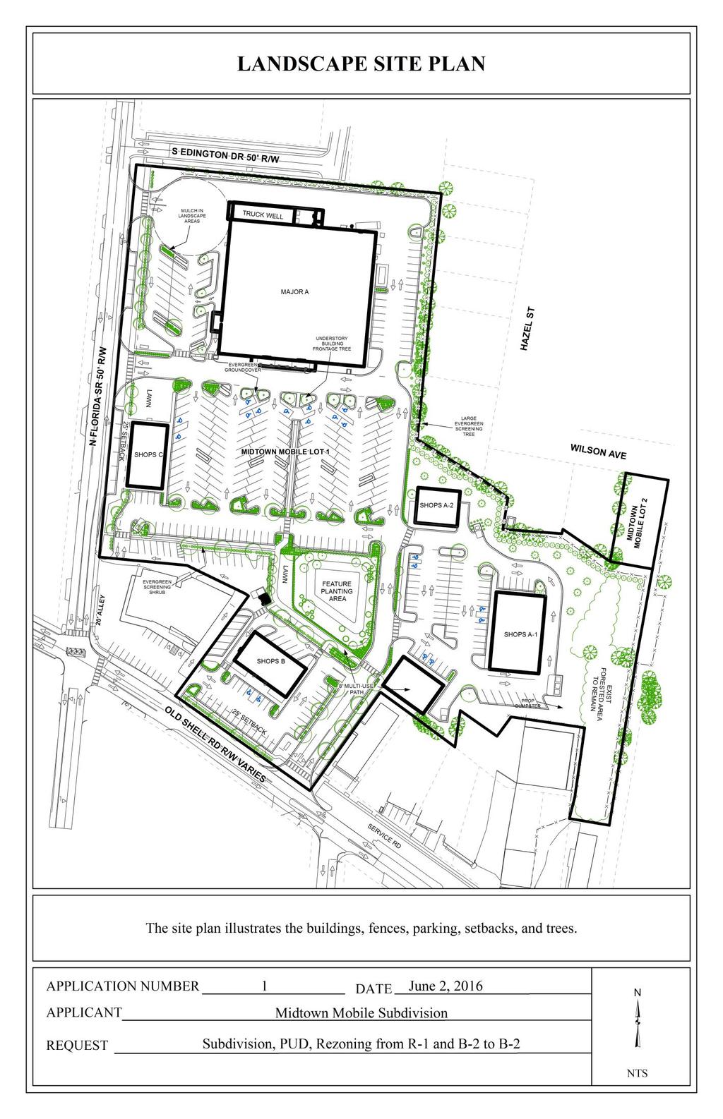
6 The applicant has had the former Augusta Evans School property under contract to purchase from the Mobile County School Board for the purpose of developing a retail shopping complex for several months. During that time there have been multiple meetings/teleconferences between the applicant, the City, and neighborhood/community representatives individually and collectively. Most of these meetings/teleconferences have been to discuss site design and compatibility. The discussions with the City have been in reference to compatibility with The Map for Mobile, and those with the neighborhood/community representatives have been in reference to a plan the Midtown Mobile Movement is developing. The City is in process of finalizing parameters and procedures for such plans to be vetted by the city before any presentation to the Planning Commission. At this time, the Midtown Mobile Movement Plan, Design Old Shell, is not fully developed or realized, and is not a plan upon which the city can base decisions. The site plan illustrates a grocery store with a pharmacy drive-thru as the anchor or main building, and four smaller retail/restaurant buildings (three of which also have a drive-thru) located on other parts of the overall site. The site plan also illustrates a cross access driveway to the existing commercial property to the West, which was part of Ashland Station, a 2008 PUD that allowed cross access and shared parking between four properties fronting Old Shell Road. Three of those properties along with most of the Augusta Evans School property are to be Lot 1 of the proposed redevelopment, therefore to maintain the shared access the fourth property had to be included. Lot 2 is to be a residential lot that fronts on Wilson Avenue, a minor residential street. Old Shell Road is shown as a Traditional Corridor on the Development Framework Map Corridors and Centers of the Map for Mobile. The Map for Mobile states that the development framework map and development area descriptions serve as a guide for future land use and design decisions and also for decisions regarding public improvements and projects. While the site is not specifically designated as a center, one could conclude, given the fact it is at an intersection on a designated Traditional Corridor, development should follow the guidelines and intent of a Traditional Center. TRADITIONAL CORRIDOR Intent Emphasize retaining historic buildings and creating appropriate, denser infill development Encourage mixed housing types including small multi-family structures along the corridor Retail and neighborhood services at intersections Combine and close driveways to create a continuous pedestrian friendly environment Auto, bicycle, transit and pedestrian traffic are accommodated More dense mixed-use development to include neighborhood services and residential above retail TRADITIONAL CENTER Intent - 6 -
7 Compatible scale (commercial, mixed-use, residential) development More dense mixed-use development to include neighborhood services and retail under residential Buildings form a continuous street wall along primary streets in the center Parking hidden behind structures Auto, bicycle, transit and pedestrian traffic are accommodated A consultant has been hired to review and rewrite the Zoning Ordinance, Subdivision Regulations, as well as develop a new Major Street Plan Map and General Land Use Plan Map. This will be a month process. Until that project is completed and the new documents are adopted, we continue to operate under the existing Zoning Ordinance and Subdivision Regulations. Under the existing Zoning Ordinance requirements for Rezoning, Planned Unit Development approval, and B-2 development standards and requirements, most elements of the proposal comply with the existing regulations. However, there appear to be some issues with the main parking lot with regard to stall depths in some areas that do not comply with the parking standards. Also related to parking - there have been numerous discussions about use of portions of the site as district parking. District parking is referenced in the Draft Design Old Shell document, and is defined therein as a shared public parking lot maintained in partnership with the City and local businesses. Currently there are no City regulations that directly address district parking. However, there is also nothing in the code that would preclude individuals from parking in one of the parking areas within the proposed development and walking to businesses, both in the proposed development and out of the proposed development; which could in essence be viewed as district parking. With regard to the proposed two lot subdivision, with one exception, the subdivision appears to comply with the existing Subdivision Regulations. It appears that a part of one of the Mobile County School Board parcels the applicant has under contract is not included in the subdivision application. Therefore, unless documentation is submitted to establish the not included area as a lot or parcel of record (with the exact legal description) prior to 1952, that partial parcel must be included in the subdivision. The applicant also submitted an Alternate Site Plan that provides on-street, head-in, angled parking spaces along Florida Street, which are partially on the private property and partially in the right-of-way. No safety lane was provided for vehicles to back out of the spaces and safely enter the traffic lane. The Traffic Engineer has reviewed this proposed alternate design modification and has indicated that any on street parking would have to be parallel spaces, not angled, head in spaces. Further, there are several design elements that do not follow the principles and vision established by The Map for Mobile. In addition to allowing the Commission to vary requirements of the Ordinance, the PUD section of the Ordinance also allows the Commission to consider other factors in rendering a decision, and require modifications to the proposed development as deemed appropriate to address those issues
8 While the previously mentioned Design Old Shell plan has not yet been completed, the Map for Mobile has been adopted by the Planning Commission as the new Comprehensive Plan for the city, and as such should be considered the guiding document for development related decisions. To this end, during meetings/teleconferences with the applicant, the staff recommended several modifications to the site plan that would embrace the principles and guidelines of the Map for Mobile, only a few of which were addressed by the applicant. An noting some last minute changes was just received, but an accompanying drawing illustrating those changes was not provided. Given the timing of receipt of the changes, the staff has not had the opportunity to fully review and prepare comments for this report. Additional information will be provided at the meeting. This is the first major development project since the adoption of the Map for Mobile. Therefore it is imperative that the proposal be scrutinized closely for inclusion of the principles and guidelines of the Map for Mobile. If the Map for Mobile is not used as the guiding document for development now, a precedent would be set regarding the applicability of the plan, and the vision expressed by and for the community may never be realized. RECOMMENDATION Subdivision: Based on the preceding, it is recommended that the Subdivision be heldover until June 2 for the following reason: 1) The plat does not include the entirety of one of the parcels in the subdivision; Revised plat and additional notification information and fees to be submitted by 12:00 pm, May 13, Planned Unit Development: Based on the preceding, it is recommended that the Planning Commission take all information, including that presented at the meeting, into consideration when rendering a decision. Staff has been made aware that there are time constraints regarding the purchase agreement and a specified time frame for closing. However, staff recommends that the PUD aspect of the request be heldover to allow the site plan to be revised to more closely correspond with the principles, guidelines, and intent of the Map for Mobile. Therefore, the PUD could be heldover until June 2, 2016 to be reconsidered with the Subdivision. The site plan does not correspond with the principles, guidelines, and intent of the Map for Mobile, therefore the following items should be addressed: 1) Reorientation of Shops B to front Old Shell Road 2) Elimination of the drive-thru, including removal of the rear drive, on Shops 1A to provide a more substantial buffer for the adjacent residential properties 3) On-site parking to meet the minimum requirements for aisle and stall sizes 4) Any on-street parking to be changed to parallel spaces, as required by the Traffic Engineer
9 Revised site plan to be submitted by 12:00 pm, May 13, Rezoning: Based on the preceding, it is recommended that the Planning Commission take all information, including that presented at the meeting, into consideration when rendering a decision. Staff has been made aware that there are time constraints regarding the purchase agreement and a specified time frame for closing. Therefore, should the Commission choose to make a decision on the rezoning, the following conditions would be recommended: 1) Development limited to an approved PUD; 2) Completion of the Subdivision process prior to the issuance of any permits; 3) Full compliance with all municipal codes and ordinances. Revised for the June 2nd meeting: The applications were heldover from the May 5 meeting to allow the applicant to make revisions to the plan that were more aligned with the guidelines and vision of The Map for Mobile, specifically the Traditional Corridor and Traditional Center guidelines/intent; and to meet with the neighborhood groups to try to effect a compromise. The applicant has submitted a revised site plan, and has had conversations with representatives from most, if not all, of the various groups - each of which has interests that are not completely aligned with the others. As noted in the original report (above), the guidelines and intent of the Traditional Corridor and Traditional center are as follows: TRADITIONAL CORRIDOR Intent Emphasize retaining historic buildings and creating appropriate, denser infill development Encourage mixed housing types including small multi-family structures along the corridor Retail and neighborhood services at intersections Combine and close driveways to create a continuous pedestrian friendly environment Auto, bicycle, transit and pedestrian traffic are accommodated More dense mixed-use development to include neighborhood services and residential above retail TRADITIONAL CENTER Intent Compatible scale (commercial, mixed-use, residential) development - 9 -
10 More dense mixed-use development to include neighborhood services and retail under residential Buildings form a continuous street wall along primary streets in the center Parking hidden behind structures Auto, bicycle, transit and pedestrian traffic are accommodated Please note, there are other aspects of the Map for Mobile to consider, as well as other Code sections that may have an impact on to what degree the site can comply with the above guidelines and intent, as well as site limitations and practicality given existing infrastructure. Staff will attempt to describe the changes in bullet list format, and then address them as they relate to the Map for Mobile, and why they may or may not comply or be practicable. The location and orientation of the main tenant, Publix, remains virtually unchanged. However, parking has been reconfigured somewhat to comply with minimum stall and aisle requirements, as well as to accommodate other changes as listed below; Shops A has been reconfigured into three buildings, each of which front onto a common parking area shared by the three buildings. A buffer of approximately from the rear service drive to the East property line is to be left in its natural vegetative state. Shops B has been reoriented to front Old Shell Road, and maintains approximately the same setback as the existing building to the West, with which there is a shared ingress/egress easement. Shops B maintain that setback in part due to the underground utilities in the vacated service road. Any type of construction involving the structure for Shops B within that vacated service road area would necessitate relocation of all of the existing underground utilities. Shops C has been relocated to the South side of the Florida Street entrance drive to provide some level of screening of main parking lot. On-Street parallel parking has been proposed adjacent to Shops C and across the entrance drive to the North (where Shops C had been previously located). The interior walkway has been extended from the rain garden / detention pond West to Florida Street to provide more pedestrian connectivity and amenities. Approximately 26% of the site will be landscaped, far exceeding the Zoning Ordinance requirement of 12%. Seventy (70) parking spaces (just over 21% of the 328 spaces provided) are identified to be surfaced with pervious paving materials. An 8-foot high opaque screen is proposed along the South Edington Drive frontage, while a 6-foot high opaque screen is proposed for the remainder of the site where it abuts residential properties. The proposed Rain Garden will be designed to be an amenity, with special plantings and a fountain. The revised site plan calls for the construction of six freestanding buildings. The architectural designs of the buildings, submitted by the applicant, take direct inspiration from traditional commercial design principles in general and notable instances of historic Mobile commercial
11 architecture in particular. Buildings located at the following addresses informed the massing and articulation of the proposed buildings: 1751 Old Shell Road (the Market building at the Southwest corner of Semmes & Old Shell); 2066 Old Shell Road (the Fuego building at the Northeast corner of Upham & Old Shell); 1714 Dauphin Street (the Mobile Popcorn building at the Northeast corner of Semmes & Dauphin); and 1301 Virginia Street (the Stadium Food Mart building at the Southwest corner of Ann & Virginia). The use of architectural features such as bulkheads, pilasters, transom windows, and other façade elements serve to compartmentalize the massing in a historically attuned manner. Materials such as brick and stucco will be employed. The historically contextualized design forms and materials work in concert to engender a pedestrian scale that will integrate the development within the larger Midtown landscape. Given the overall configuration of the site, the location of Shops A is not within an area of the site to which the location and orientation of buildings as noted in a Traditional Center can realistically be applied. Further, the proposed Shops A, along with the existing buildings along Old Shell Road, would provide screening of that parking area from not only Old Shell, but also the residential properties to the North and East. While Shops B may not be relocated to the front property line, it has been reoriented to the street and is basically in line with the building to the West; arguably, with these changes it could be considered a liner building or as close as may be practicable for this part of the overall site. The relocation and reorientation of Shop C provides a liner building for part of the main parking area which screens much of it from Florida Street. While it is not the continuous length of the Florida Street frontage, there are extenuating circumstances that preclude it from continuing to the South property line; also the entrance drive to the North limits the building footprint in that direction. On Street, parallel parking spaces are illustrated on Florida Street, adjacent to Shop C and North of the Entrance Drive. The parking demand by the tenant, as well as the overall total parking requirement assuming food and/or beverage businesses with on-site consumption in some of the tenant spaces, does not allow for further reduction in parking spaces. The Zoning Ordinance requirement for the proposed mix of tenants is 239 parking spaces, and the revised site plan depicts a total of 328 parking spaces based upon tenant requirements. The parking areas are situated such that one provides parking for the grocery store and Shops C, another for Shops A1, A2, and A3, and the third for Shops B (some of which will most likely be used by patrons of the building to the West). As with any plan or code, there may be circumstances that necessitate or warrant a deviation; such as the existing infrastructure located in the vacated service road right-of-way, which prevents the Shops B from moving as close to Old Shell Road as desired by the neighbors. Does absolute adherence to that single element of the plan justify the cost to the developer of
12 relocating those infrastructure improvements; or does the location and reorientation of the Shops B to follow the existing buildings to the West and East accomplish the intent? Redevelopment of those properties would almost certainly have the same issues and thus be redeveloped in a similar manner to Shops B. Planned Unit Development review examines the site with regard to its location to ensure that it is generally compatible with neighboring uses; that adequate access is provided without generating excess traffic along minor residential streets in residential districts outside the PUD; and that natural features of the site are taken into consideration. PUD review also examines the design of the development to provide for adequate circulation within the development; to ensure adequate access for emergency vehicles; and to consider and provide for protection from adverse effects of adjacent properties as well as provide protection of adjacent properties from adverse effects from the PUD. PUD approval is site plan specific, thus if any new construction is anticipated that will change an approved site plan, an application to amend an existing, approved PUD must be made prior to any construction activities. Throughout the process, various groups have been very vocal and have made their desires relating to the proposed development known to the applicant and to the City. Most cite The Map for Mobile, Traditional Corridor and Traditional Center aspects. What has not been referenced is that The Map for Mobile is a year plan, and as such does not presume that every development, especially major developments, will include every element of The Map for Mobile for every part of the development in its initial phase. It is a process; one that takes many years to be fully realized. The applicant has submitted several revised versions of the site plan while working through the process, trying to address concerns and issues raised by the neighborhood groups and the City. The revised plan now before the Commission may not check every box for everyone, but certainly represents the applicant s diligence in working towards a site plan that reflects many of The Map for Mobile guidelines given the constraints of the site, the utilities and infrastructure located under the vacated service road, and the irregularly shaped property. RECOMMENDATION Subdivision: Based on the preceding, the plat is recommended for Tentative Approval subject to the following conditions: 1) Compliance with Engineering Comments: (The following comments should be addressed prior to submitting the FINAL PLAT for acceptance and signature by the City Engineer: A. Provide all of the required information on the SUBDIVISION PLAT (i.e. signature blocks, signatures, certification statements, written legal description, required notes, legend, scale, bearings and distances) that is required by the current Alabama State Board of Licensure for Professional Engineers and Land Surveyors. B. Provide a signature and seal from a surveyor that is licensed in Alabama not Georgia. C. Provide a legend. D. Correct S Edington Drive to Edington Drive South in the vicinity map, plan sheet, and written legal description. E. Dedicate the corner radius (25 minimum or as approved by the City Engineer and Traffic Engineer) at the northwest corner of LOT 1 (Florida St and Edington Dr. S.). F. Label beginning point as POB to match the written legal description. G. Show
13 and label Jackson Place, Lot 12 that is referred to in the written Legal Description. H. Show and label each and every Right-Of-Way and their width, including Edington Drive and Hazel Street. Show the ROW width of Old Shell Rd at the two (2) corners of LOT 1 that are adjacent to Old Shell Rd. I. Add a signature block for the Owner, Notary Public, Planning Commission, Traffic Engineer, and City Engineer. J. Provide the Surveyor s Certificate and Signature. K. Provide the Surveyor s, Owner s (notarized), Planning Commission, and Traffic Engineering signatures. L. Show and label any proposed easements (drainage, utility, access, etc.). M. Add a note to the SUBDIVISION PLAT stating that a Land Disturbance permit will be required for any land disturbing activity in accordance with Mobile City Code, Chapter 17, Storm Water Management and Flood Control); the City of Mobile, Alabama Flood Plain Management Plan (1984); and, the Rules For Erosion and Sedimentation Control and Storm Water Runoff Control. N. Add a note to the SUBDIVISION PLAT stating that as shown on the 1984 aerial photo (FLIGHT 26 - #77) the Lot(s) will receive historical credit of impervious area towards stormwater detention requirement per Mobile City Code, Chapter 17, Storm Water Management and Flood Control). O. Add a note to the Plat stating that the approval of all applicable federal, state, and local agencies (including all storm water runoff, wetland and floodplain requirements) will be required prior to the issuance of a Land Disturbance permit. P. Add a note that sidewalk is required to be constructed, and/or repaired, along the frontage of each lot, or parcel, at time of new development or construction, unless a sidewalk waiver is approved. Q. Provide a copy of the FINAL PLAT to the Engineering Dept. for FINAL PLAT review prior to obtaining any signatures. R. After the Engineering Dept. Final Plat review is complete, provide a copy of the revised Final Plat along with the original when submitting for City Engineer signature. S. Due to the proposed development on LOT 1 the proposed structures will need to be addressed. Please contact the Engineering Department ( ) to discuss the options prior to submitting any building, land disturbance, or ROW permits.); 2) Compliance with revised Traffic Engineering comments (A traffic impact study was completed for this site. The development intensity illustrated on the PUD plan is approximately 2,000 SF less than the intensity accounted for in the study. The site plan has also been revised to reduce the number of driveways on Old Shell Road. The reduced square footage would generate the approximate number of trips assumed to use the second driveway on Old Shell Road, therefore an updated study is not required for these changes. Development is contingent upon the completion of off-site improvements as indicated in the study. Adequate dedication should be included on any street right-of-way to allow for adequate travel lanes as well as utility/green/sidewalk area. Corner radii dedication should be required at North Florida Street and Edington Drive. Lot 1 is limited to two curb cuts to North Florida Street, limited to one curb cut to Old Shell Road, and denied access to South Edington Drive. Lot 2 is limited to one curb cut to Wilson Avenue. Driveway size, location and design to be approved by Traffic Engineering and conform to AASHTO standards. Required on-site parking, including ADA handicap spaces, shall meet the minimum standards as defined in Section 64-6 of the City s Zoning Ordinance. Porous pavement parking will need to consist of a design appropriate means to designate individual parking spaces. Consistent with the Avenue typology, parallel on-street parking has been included with a buffer area adjacent to the travel lane to reduce the amount of maneuvering in the right-of-way. On-street parking may require either right-of-way dedication or a right-of-way use agreement. The traffic impact study should be updated to analyze the impacts the onstreet parking will have on the roadway level of service. Owner/developer will be
14 responsible for obtaining consent from the adjacent land owner(s) on Old Shell Road for any site improvements (e.g. driveway radius) that extend in front of the adjacent property frontage. In conjunction with any permit submittals, turning templates may be necessary to justify larger than standard 20 driveway radii.); 3) Dedication of sufficient right-of-way along North Florida St to accommodate adequate travel lanes, the proposed on-street parking, green space, and sidewalks; 4) Radii dedication at North Florida Street and Edington Drive, in compliance with Section V.D.6. of the Subdivision Regulations; 5) Placement of a note on the Final Plat stating Lot 1 is limited to two curb cuts to North Florida Street, limited to one curb cut to Old Shell Road, and denied access to South Edington Drive, and that Lot 2 is limited to one curb cut to Wilson Avenue, with the size, design and location to be approved by Traffic Engineering and comply with AASHTO standards; 6) Dedication of sufficient right-of-way along Old Shell Road to accommodate adequate travel lanes, green space, and sidewalks; 7) Compliance with Fire Department Comments: (All projects within the City Limits of Mobile shall comply with the requirements of the City of Mobile Fire Code Ordinance. (2012 International Fire Code)); 8) Compliance with Urban Forestry Comments: (Property to be developed in compliance with state and local laws that pertain to tree preservation and protection on both city and private properties (State Act and City Code Chapters 57 and 64)); 9) Provision of a revised PUD site plan prior to the signing of the final plat; and 10) Completion of the Subdivision process prior to any permit requests for new construction (demolition is OK). Planned Unit Development: Based on the preceding, the revised PUD is recommended for Approval subject to the following conditions: 1) Compliance with revised Engineering Comments: (1. Due to the proposed development on LOT 1 the proposed structures will need to be addressed. Please contact the Engineering Department ( ) to discuss the options prior to submitting any building, land disturbance, or ROW permits. 2. Show and label the proposed improvements on Florida St. and Old Shell Rd. (i.e. widening to 3 lanes, add/extend turn lane) and a note that the improvements will be as approved by the City Engineer and Traffic Engineer. ADD THE FOLLOWING NOTES TO THE PUD SITE PLAN: 1. Any work performed in the existing ROW (right-of-way) such as driveways, sidewalks, utility connections, grading, drainage, irrigation, or landscaping will require a ROW permit from the City of Mobile Engineering Department ( ) and must comply with the City of Mobile Right-of-Way Construction and Administration Ordinance (Mobile City Code, Chapter 57, Article VIII). 2. A Land Disturbance Permit application shall be submitted for any proposed land disturbing activity with the property. A complete set of construction plans including, but not limited to, drainage, utilities, grading, storm water detention systems, paving, and all above ground structures, will need to be included with the Land Disturbance permit. This Permit must be submitted, approved, and issued prior to beginning any of the construction work. 3. This project will require that a perpetual maintenance agreement be reviewed, approved, and recorded for the onsite detention/retention system, including the outfall structure and pipes that connect to the City maintained drainage system. 4. Any and all proposed land disturbing activity within the property will need to be submitted for review and be in
15 conformance with Mobile City Code, Chapter 17, Storm Water Management and Flood Control); the City of Mobile, Alabama Flood Plain Management Plan (1984); and, the Rules For Erosion and Sedimentation Control and Storm Water Runoff Control. 5. The approval of all applicable federal, state, and local agencies (including all storm water runoff, wetland and floodplain requirements) will be required prior to the issuance of a Land Disturbance permit. The Owner/Developer is responsible for acquiring all of the necessary permits and approvals. 6. The proposed development must comply with all Engineering Department design requirements and Policy Letters.); 2) Compliance with revised Traffic Engineering Comments: (A traffic impact study was completed for this site. The development intensity illustrated on the PUD plan is approximately 2,000 SF less than the intensity accounted for in the study. The site plan has also been revised to reduce the number of driveways on Old Shell Road. The reduced square footage would generate the approximate number of trips assumed to use the second driveway on Old Shell Road, therefore an updated study is not required for these changes. Development is contingent upon the completion of off-site improvements as indicated in the study. Adequate dedication should be included on any street right-of-way to allow for adequate travel lanes as well as utility/green/sidewalk area. Corner radii dedication should be required at North Florida Street and Edington Drive. Lot 1 is limited to two curb cuts to North Florida Street, limited to one curb cut to Old Shell Road, and denied access to South Edington Drive. Lot 2 is limited to one curb cut to Wilson Avenue. Driveway size, location and design to be approved by Traffic Engineering and conform to AASHTO standards. Required on-site parking, including ADA handicap spaces, shall meet the minimum standards as defined in Section 64-6 of the City s Zoning Ordinance. Porous pavement parking will need to consist of a design appropriate means to designate individual parking spaces. Consistent with the Avenue typology, parallel on-street parking has been included with a buffer area adjacent to the travel lane to reduce the amount of maneuvering in the right-of-way. On-street parking may require either right-of-way dedication or a right-ofway use agreement. The traffic impact study should be updated to analyze the impacts the on-street parking will have on the roadway level of service. Owner/developer will be responsible for obtaining consent from the adjacent land owner(s) on Old Shell Road for any site improvements (e.g. driveway radius) that extend in front of the adjacent property frontage. In conjunction with any permit submittals, turning templates may be necessary to justify larger than standard 20 driveway radii.); 3) Compliance with Fire Department Comments: (All projects within the City Limits of Mobile shall comply with the requirements of the City of Mobile Fire Code Ordinance. (2012 International Fire Code)); 4) Compliance with Urban Forestry Comments: (Property to be developed in compliance with state and local laws that pertain to tree preservation and protection on both city and private properties (State Act and City Code Chapters 57 and 64)); 5) The area North of Shops A1 and North and East of the service drive for Shops A2 to remain in a natural vegetative state to the greatest degree practicable; and, 6) Provision of an 8 masonry wall along Edington Drive as illustrated on the site plan. Rezoning: Based on the preceding, it is recommended that this application be recommended for approval, subject to the following conditions: 1) Development limited to an approved PUD;
16 2) Completion of the Subdivision process prior to the issuance of permits for building construction; and 3) Full compliance with all municipal codes and ordinances
17
18
19
20
21
22
23
PLANNED UNIT DEVELOPMENT & SUBDIVISION STAFF REPORT Date: May 18, 2017
 & PUD-0000102-2017 PLANNED UNIT DEVELOPMENT & SUBDIVISION STAFF REPORT Date: May 18, 2017 NAME SUBDIVISION NAME Dauphin Creek Estates Subdivision Dauphin Creek Estates Subdivision LOCATION CITY COUNCIL
PLANNED UNIT DEVELOPMENT STAFF REPORT Date: June 2, 2016
 # 9 ZON2016-01032 PLANNED UNIT DEVELOPMENT STAFF REPORT Date: June 2, 2016 DEVELOPMENT NAME JJT Properties LLC LOCATION 1147 & 1151 East I-65 Service Road South and 1180 Sledge Drive (Southeast corner
THE CITY OF MOBILE, ALABAMA
 THE CITY OF MOBILE, ALABAMA LETTER OF DECISION Ark of Safety, Inc. Mobile, AL 36617 Re: (Northwest corner of Main Street and First Avenue, extending to the Southwest corner of Esau Avenue and Main Street.)
PLANNED UNIT DEVELOPMENT Date: April 5, 2018
 PLANNED UNIT DEVELOPMENT Date: April 5, 2018 DEVELOPMENT NAME SUBDIVISION NAME LOCATION Robert Myers Robert Myers 2955 and 2989 Dauphin Street (Southeast corner of Dauphin Street and Sage Avenue) CITY
SUBDIVISION, PLANNED UNIT DEVELOPMENT, PLANNING APPROVAL, REZONING & SIDEWALK WAIVER STAFF REPORT Date: February 7, 2013
 SUBDIVISION, PLANNED UNIT DEVELOPMENT, PLANNING APPROVAL, REZONING & SIDEWALK WAIVER STAFF REPORT Date: February 7, 2013 APPLICANT NAME SUBDIVISION NAME DEVELOPMENT NAME LOCATION S. E. Cemeteries of AL
ZONING AMENDMENT & PLANNED UNIT DEVELOPMENT STAFF REPORT Date: April 4, 2013
 ZONING AMENDMENT & PLANNED UNIT DEVELOPMENT STAFF REPORT Date: April 4, 2013 NAME DEVELOPMENT NAME LOCATION DIP Exchange, LLC DIP Exchange, LLC 93 Sidney Phillips Drive (West side of Sidney Phillips Drive,
PLANNING APPROVAL & PLANNED UNIT DEVELOPMENT Date: November 2, 2017
 PLANNING APPROVAL & PLANNED UNIT DEVELOPMENT Date: November 2, 2017 DEVELOPMENT NAME LOCATION Mobile Christian School 5900 Cottage Hill Road (North side of Cottage Hill Road, 230 ± West of Freemont Drive
PLANNING APPROVAL & SIDEWALK WAIVER STAFF REPORT Date: December 1, 2016
 PLANNING APPROVAL & SIDEWALK WAIVER STAFF REPORT Date: December 1, 2016 NAME Dennis P. Wilkins LOCATION. CITY COUNCIL DISTRICT District 6 7078 Bruns Drive (Northeast corner of Bruns Drive and Cody Road)
PLANNING APPROVAL & PLANNED UNIT DEVELOPMENT Date: April 6, 2017
 PLANNING APPROVAL & PLANNED UNIT DEVELOPMENT Date: April 6, 2017 DEVELOPMENT NAME LOCATION Mobile Christian School 5900 Cottage Hill Road (North side of Cottage Hill Road, 230 ± West of Freemont Drive
PLANNED UNIT DEVELOPMENT Date: May 4, 2017
 PLANNED UNIT DEVELOPMENT Date: May 4, 2017 DEVELOPMENT NAME LOCATION Sarah & Michael Stashak 2165 & 2167 Old Shell Road (South side of Old Shell Road, at the Southern terminus of Frazier Court) CITY COUNCIL
PLANNED UNIT DEVELOPMENT & SUBDIVISION STAFF REPORT Date: March 15, 2012
 PLANNED UNIT DEVELOPMENT & SUBDIVISION STAFF REPORT Date: March 15, 2012 DEVELOPMENT NAME SUBDIVISION NAME LOCATION OSR Subdivision OSR Subdivision 5559 Old Shell Road (South side of Old Shell Road, 570
PLANNED UNIT DEVELOPMENT & PLANNING APPROVAL STAFF REPORT Date: April 4, 2013
 PLANNED UNIT DEVELOPMENT & PLANNING APPROVAL STAFF REPORT Date: April 4, 2013 NAME LOCATION The North American Islamic Trust, Inc. 63 East Drive (East side of East Drive, 400 South of Old Shell Road, and
ZONING AMENDMENT, PLANNED UNIT DEVELOPMENT & SUBDIVISION STAFF REPORT Date: March 20, 2008
 ZONING AMENDMENT, PLANNED UNIT DEVELOPMENT & SUBDIVISION STAFF REPORT Date: March 20, 2008 NAME SUBDIVISION NAME LOCATION Joseph Mramor Mramor s Addition to Weinacker Avenue Subdivision 900 Weinacker Avenue
SUBDIVISION, REZONING, PLANNING APPROVAL, PUD & SIDEWALK WAIVER STAFF REPORT Date: May 3, 2007
 SUBDIVISION, REZONING, PLANNING APPROVAL, PUD & SIDEWALK WAIVER STAFF REPORT Date: May 3, 2007 APPLICANT NAME SUBDIVISION NAME LOCATION TOG Properties, LLC Highland Professional Park, Resubdivision of
CITY OF MOBILE MOBILE CITY PLANNING COMMISSION LETTER OF DECISION. November 5, 2012
 SAMUEL L. JONES MAYOR CITY OF MOBILE LETTER OF DECISION OFFICE OF THE CITYCOUNCIL COUNCIL MEMBERS REGGIE COPELAND, SR. PRESIDENT-DISTRICT 5 FREDRICK D. RICHARDSON, JR. VICE PRESIDENT-DISTRICT 1 WILLIAM
Drexel, Barrell & Co.
 Drexel, Barrell & Co. June 18, 2018 Engineers/Surveyors Boulder Colorado Springs Greeley 3 South 7 th Street Colorado Springs, Colorado 80905-1501 719 260-0887 719 260-8352 Fax El Paso County Planning
Drexel, Barrell & Co.
 Drexel, Barrell & Co. December 21, 2018 Engineers/Surveyors Boulder Colorado Springs Greeley 3 South 7 th Street Colorado Springs, Colorado 80905-1501 719 260-0887 719 260-8352 Fax El Paso County Planning
# 17 & 18 ZON & ZON PLANNED UNIT DEVELOPMENT & PLANNING APPROVAL STAFF REPORT Date: February 5, Mobile Carnival Association
 PLANNED UNIT DEVELOPMENT & PLANNING APPROVAL STAFF REPORT Date: February 5, 2009 NAME LOCATION Mobile Carnival Association South side of Bloodgood Street at its West terminus CITY COUNCIL DISTRICT District
SITE PLAN REVIEW APPLICATION AND CHECKLIST
 SITE PLAN REVIEW APPLICATION AND CHECKLIST PROJECT SUMMARY: Project Name: City/ETA Location: City ETA (Application fee & number of copies needed are based on location) Property Location (Legal Description
SITE PLAN REVIEW ITEMS - REFERENCE CHECKLIST
 City of Seminole 9199 113 th Street N. Seminole, FL 33772 Ph: (727) 392-1966 Fx: (727) 319-6583 SITE PLAN REVIEW ITEMS - REFERENCE CHECKLIST Note: This checklist is designed to aid designers in the review
# 3 & 4 HOLDOVER ZON & ZON PLANNED UNIT DEVELOPMENT & PLANNING APPROVAL STAFF REPORT Date: June 4, 2009
 PLANNED UNIT DEVELOPMENT & PLANNING APPROVAL STAFF REPORT Date: June 4, 2009 NAME LOCATION Mobile Carnival Association, Inc. 561 Stuart Circle (South side of Bloodgood Street at its West terminus) CITY
VILLAGE OF CLEMMONS PLANNING BOARD DRAFT STAFF REPORT. Single Family Residential, Townhomes
 VILLAGE OF CLEMMONS PLANNING BOARD DRAFT STAFF REPORT PETITION INFORMATION Docket # C-212 Staff Megan Ledbetter Petitioner(s) Peacehaven Development LLC Owner(s) Larry Jarvis, William Alexander and Peacehaven
McDonald s Restaurant - Purcellville Town of Purcellville Special Use Permit Statement of Justification July 24, 2014
 Introduction / Written Statement McDonald s Restaurant - Purcellville McDonald s Corporation is proposing to redevelop the existing McDonald s eating establishment with a drive-through located at 121 N
VILLAGE OF CLEMMONS PLANNING BOARD DRAFT STAFF REPORT
 VILLAGE OF CLEMMONS PLANNING BOARD DRAFT STAFF REPORT PETITION INFORMATION Docket # C-226 Staff Megan Ledbetter Petitioner(s) JBJH Properties, LLC Owner(s) JBJH Properties, LLC Subject Property 5892-49-1766
PLANNING APPROVAL STAFF REPORT Date: November 17, 2011
 # 11 ZON2011-02680 PLANNING APPROVAL STAFF REPORT Date: November 17, 2011 NAME LOCATION Alabama Power Company East side of Navco Road 130 ± South of Columbus Avenue CITY COUNCIL DISTRICT District 4 PRESENT
ARTICLE 6: Special and Planned Development Districts
 ARTICLE 6: Special and Planned Development Districts 6-10 Traditional Neighborhood Development (TND) District 6-10.10 Purpose and Intent The Traditional Neighborhood Development (TND) District provides
D1 September 11, 2013 Public Hearing APPLICANT:
 D1 September 11, 2013 Public Hearing APPLICANT: BEACH MUNICIPAL FEDERAL CREDIT UNION PROPERTY OWNER: SISTERS II, LLC STAFF PLANNER: Karen Prochilo REQUEST: Conditional Change of Zoning (AG-2 Agriculture
MOBILE CITY PLANNING COMMISSION LETTER OF DECISION. October 22, 2010
 MOBILE CITY PLANNING COMMISSION LETTER OF DECISION Archbishop of Mobile 400 Government St. Mobile, AL 36602 Re: Case #SUB2010-00075 (Subdivision) 3650 Springhill Avenue (Northwest corner of Springhill
Planning Commission Staff Report June 5, 2008
 Owner/Applicant Taylor Village Sacramento Investments Partners, LP c/o Kim Whitney 1792 Tribute Road #270 Sacramento, CA 95815 Staff Recommendation Planning Commission Staff Report Project: File: Request:
8 8 CITY OF MOBILE MOBILE CITY PLANNING COMMISSION LETTER OF DECISION. November 5, 2012
 SAMUEL L. JONES 8 8 November 5, 2012 PRESIDENT-DISTRICT S FREDRICK D. RICHARDSON, JR. VICE PRESIDENT-DISTRICT I JOHN C. WILLIAMS DISTRICT4 DISTRICT6 DISTRICT 7 Cummings Architecture Corporation Case #SUB2012-00087
ZONING ORDINANCE FOR THE ZONED UNINCORPORATED AREAS ARTICLE 1150 OF PUTNAM COUNTY, WEST VIRGINIA Page 95 ARTICLE 1150 SITE PLAN REVIEW
 OF PUTNAM COUNTY, WEST VIRGINIA Page 95 1150.01 PURPOSE 1150.02 APPLICABILITY 1150.03 APPLICATION PROCESS 1150.04 REVIEW PROCESS 1150.05 REVIEW CRITERIA 1150.06 SITE PLAN GUIDELINES 1150.01 PURPOSE ARTICLE
City of Mt. Juliet Planning & Zoning Department. Site Plan Checklist. Site plan cklist v1.18
 City of Mt. Juliet Planning & Zoning Department Site Plan Checklist Site Plan approval is required for all specified community facilities, all commercial, industrial, and multi-family residential activities
Design Review Application *Please call prior to submittal meeting to determine applicable fees*
 CITY OF EAGLE 660 E. Civic Lane, Eagle, ID 83616 Phone#: (208) 939-0227 Fax: (208) 938-3854 Design Review Application *Please call prior to submittal meeting to determine applicable fees* FILE NO.: CROSS
Staff Report and Recommendation
 Community Planning and Development Planning Services 201 W. Colfax Ave., Dept. 205 Denver, CO 80202 p: 720.865.2915 f: 720.865.3052 www.denvergov.org/cpd TO: City Council Neighborhoods and Planning Committee
Approved: CITY OF ARDEN HILLS, MINNESOTA PLANNING COMMISSION WEDNESDAY, AUGUST 5, :30 P.M. - ARDEN HILLS CITY HALL
 Approved: CITY OF ARDEN HILLS, MINNESOTA PLANNING COMMISSION WEDNESDAY, AUGUST 5, 2015 6:30 P.M. - ARDEN HILLS CITY HALL PLANNING CASES A. Planning Case 15-016; Final Planned Unit Development Arden Plaza;
PRELIMINARY PLAT DESIGN REQUIREMENTS Updated 4/8/2016
 PRELIMINARY PLAT DESIGN REQUIREMENTS Updated 4/8/2016 The following items are required for the preliminary plat. Numbers correspond with those on the example preliminary plat. RENO COUNTY SUBDIVISION REQUIREMENTS
PLANNED UNIT DEVELOPMENT APPLICATION
 PLANNED UNIT DEVELOPMENT APPLICATION CITY OF THE DALLES Community Development Department 313 Court Street The Dalles, OR 97058 (541) 296-5481, ext. 1125 Fax (541) 298-5490 www.ci.the-dalles.or.us Date
14 October 10, 2012 Public Hearing APPLICANT: MPB, INC
 14 October 10, 2012 Public Hearing APPLICANT: MPB, INC PROPERTY OWNER: MUNDEN & ASSOCIATES, LP STAFF PLANNER: Karen Prochilo REQUEST: Conditional Change of Zoning (AG-1 & AG-2 to Conditional O-2) ADDRESS
ARTICLE 17 SITE PLAN REVIEW
 ARTICLE 17 SITE PLAN REVIEW 17.01 INTENT AND PURPOSE The intent of this section is to provide for consultation and cooperation between the applicant and the township planning commission so that the applicant
Request Change in Nonconformity. Staff Recommendation Approval. Staff Planner Jonathan Sanders
 Applicant & Owner Public Hearing April 11, 2018 City Council Election District Beach Agenda Item 5 Request Change in Nonconformity Staff Recommendation Approval Staff Planner Jonathan Sanders Location
SUBMITTAL REQUIREMENTS
 WHEN PROCESS TYPE III IS USED References to Process Type III applications are found in several places in the Milton Municipal Code (MMC), indicating that the development, activity, or use, is permitted
MONTGOMERY COUNTY PLANNING DEPARTMENT THE MARYLAND-NATIONAL CAPITAL PARK AND PLANNING COMMISSION
 MONTGOMERY COUNTY PLANNING DEPARTMENT THE MARYLAND-NATIONAL CAPITAL PARK AND PLANNING COMMISSION MCPB Item No. Date: 3.10.2016 Site Plan 820160040 Nora School Parker Smith, Planning Technician, Area 1,
PARKLET PROPOSAL PACKAGE & PROCESS
 500.3 I PARKLETS The term parklet refers to a small temporary constructed seating or community gathering area over an on-street parking space or an extension of the sidewalk into the operating State highway
MIDTOWN MIXED-USE VILLAGE. TECHNICAL DATA SHEET COMPONENT C-1 FOR PUBLIC HEARING - PETITION NUMBER Project No RZ1.1. Issued.
 N MIDTOWN MIXED-USE VILLAGE TECHNICAL DATA SHEET COMPONENT C- FOR PUBLIC HEARING - PETITION NUMBER 04-00 Project No. 496 Issued Revised SCALE: " = 0' N 0 0 0 40 RZ. c GENERAL PROVISIONS: a. SITE LOCATION.
COMMUNITY DESIGN. GOAL: Create livable and attractive communities. Intent
 COMMUNITY DESIGN Intent An attractive, well-designed County will attract quality development, instill civic pride, improve the visual character of the community, and create a strong, positive image for
APPLICATION FOR REZONING PROPERTY CITY OF HOLLAND, MICHIGAN. Name of Applicant. Address, and Phone # of Applicant
 APPLICATION FOR REZONING PROPERTY CITY OF HOLLAND, MICHIGAN Name of Applicant Address, Email and Phone # of Applicant Name and Address of Owner (if other than applicant) Ownership Interest of Applicant
M E M O R A N D U M July 27, 2018
 M E M O R A N D U M July 27, 2018 To: Southlake 2035 Corridor Planning Committee From: Kenneth Baker, Sr. Director of Planning and Development Services Subject: Item #6 First National Bank Purpose Review,
CITY-COUNTY PLANNING BOARD DRAFT STAFF REPORT
 CITY-COUNTY PLANNING BOARD DRAFT STAFF REPORT PETITION INFORMATION Docket # W-3174 Staff Aaron King Petitioner(s) O Reilly Auto Parts Owner(s) Glenn Crossing Associates, LLC Subject Property Portion of
PRELIMINARY CONDITIONAL USE SUBMITTAL CHECKLIST REQUIREMENTS
 This checklist must accompany your submittal as the cover page. CONDITIONAL USE Application Submittal Checklist for PRELIMINARY AND FINAL APPROVAL Per Winter Park Land Development Code Sec. 58-90 PRELIMINARY
Checklists. Project Name: Location: File Number: Date of Submittal: Reviewer: Date: Applicant: Contact Name: Phone Number:
 Applicant: Contact Name: Phone Number: Email: Project Name: Location: File Number: Date of Submittal: Reviewer: Date: Concept Plan Requirements: I. General Project Information 1. Address or parcel number
ORDINANCE WHEREAS, this Ordinance is consistent with the City of Winter Garden Comprehensive Plan; and
 ORDINANCE 17-06 AN ORDINANCE OF THE CITY COMMISSION OF THE CITY OF WINTER GARDEN, FLORIDA, CREATING ARTICLE XIV OF CHAPTER 118 OF THE CITY OF WINTER GARDEN CODE OF ORDINANCES PROVIDING FOR THE EAST PLANT
PART 1: PROJECT SUMMARY. Proposed Land Use: 120 single-family lots. The application is Attachment A. The site plan is Attachment B.
 PART 1: PROJECT SUMMARY Applicant: JBH Development, LLC and Hopper Communities, INC Project Size: +/- 80.48 acres Parcel Number: 01513107, 01513108, 01513109, 01513113, 01513120, 01513121, 01513122, 01513124,
SEMSWA s Role in the Land Development Process
 SEMSWA s Role in the Land Development Process One of SEMSWA s responsibilities is to ensure that any new development or redevelopment within its service area is designed and constructed in compliance with
VILLAGE OF CLEMMONS PLANNING BOARD DRAFT STAFF REPORT
 VILLAGE OF CLEMMONS PLANNING BOARD DRAFT STAFF REPORT PETITION INFORMATION Docket # C-214 Staff Megan Ledbetter Petitioner(s) Summit Healthcare Group Owner(s) Wake Forest University Health Services Subject
STORMWATER MANAGEMENT CODES ANALYSIS RICHLAND COUNTY, SC SITE PLANNING ROUNDTABLE
 STORMWATER MANAGEMENT CODES ANALYSIS RICHLAND COUNTY, SC SITE PLANNING ROUNDTABLE Codes analyses for each subcommittee were completed to assist participants of the Richland County Site Planning Roundtable.
AWH REPORT OF THE PLANNING AND DEVELOPMENT DEPARTMENT FOR APPLICATION FOR REZONING ORDINANCE TO PLANNED UNIT DEVELOPMENT
 AWH REPORT OF THE PLANNING AND DEVELOPMENT DEPARTMENT FOR APPLICATION FOR REZONING ORDINANCE TO PLANNED UNIT DEVELOPMENT MAY 8, 2014 The Planning and Development Department hereby forwards to the Planning
City of Reedley Community Development Department 1733 Ninth Street Reedley, CA (559) FAX
 FAX") City of Reedley SPECIAL PERMIT Submittal Requirements Conditional Use Permit (CUP), Site Plan Review (SPR) & Variance (VAR) Please use this information sheet as a checklist to assemble materials required
City of Reedley SPECIAL PERMIT Submittal Requirements Conditional Use Permit (CUP), Site Plan Review (SPR) & Variance (VAR) Please use this information sheet as a checklist to assemble materials required
SITE PLAN REVIEW APPLICATION
 SITE PLAN REVIEW APPLICATION CITY OF THE DALLES Community Development Department 313 Court Street The Dalles, OR 97058 (541) 296-5481, ext. 1125 Fax (541) 298-5490 www.ci.the-dalles.or.us Date Filed File#
Developer s Program. The Station at East 54
 Developer s Program The Station at East 54 Existing Conditions The Station at East 54 is proposed for a 1.12 acre site at the northeast corner of Hamilton Road and Prestwick Road, tucked between the East
Mitchell Ranch South MPUD Application for Master Planned Unit Development Approval Project Narrative. Introduction
 Mitchell Ranch South MPUD Application for Master Planned Unit Development Approval Project Narrative Introduction Mitchell Ranch South is a proposed single family (detached) residential development on
Watertown City Council
 City of Watertown Watertown City Council April 14 th, 2015 Agenda Item: City Comment on Sun Share CUP Application Request for Action: Motion to Approve City Comments regarding CUP Application Department:
PLANNED DEVELOPMENT (MASTER PLAN & UNIT PLAN)
") Central Permit Center 555 Santa Clara Street Vallejo CA 94590 Business License Building Fire Prevention Planning Public Works 707.648.4310 707.648.4374 707.648.4565 707.648.4326 707.651.7151 PLANNED DEVELOPMENT
Central Permit Center 555 Santa Clara Street Vallejo CA 94590 Business License Building Fire Prevention Planning Public Works 707.648.4310 707.648.4374 707.648.4565 707.648.4326 707.651.7151 PLANNED DEVELOPMENT
SPECIFIC PLAN Requirements
 CITY OF LANCASTER PLANNING DEPARTMENT 44933 Fern Avenue, Lancaster, California 93534 (661) 723-6100 SPECIFIC PLAN Requirements Purpose The purpose of a specific plan is to provide for the logical development
REQUEST Current Zoning: O-15(CD) (office) Proposed Zoning: TOD-M(CD) (transit oriented development mixed-use, conditional)
 (office) Proposed Zoning: TOD-M(CD) (transit oriented development mixed-use, conditional)") Rezoning Petition 2016-117 Zoning Committee Recommendation January 4, 2017 REQUEST Current Zoning: O-15(CD) (office) Proposed Zoning: TOD-M(CD) (transit oriented development mixed-use, conditional) LOCATION
Rezoning Petition 2016-117 Zoning Committee Recommendation January 4, 2017 REQUEST Current Zoning: O-15(CD) (office) Proposed Zoning: TOD-M(CD) (transit oriented development mixed-use, conditional) LOCATION
CHAPTER SPECIAL PURPOSE AND OVERLAY ZONING DISTRICTS
 Special Purpose and Overlay Zoning Districts 106.28.010 CHAPTER 106.28 - SPECIAL PURPOSE AND OVERLAY ZONING DISTRICTS SPECIAL PURPOSE AND OVERLAY ZONING DISTRICTS Sections: 106.28.010 - Purpose 106.28.020
10 October 14, 2015 Public Hearing
 10 October 14, 2015 Public Hearing APPLICANT: PROPERTY OWNER: VIRGINIA BEACH BEACON BAPTIST CHURCH STAFF PLANNER: Stephen J. White REQUESTS: A. Change of Zoning (R-20 Residential District to Conditional
ARTICLE RRCO RED ROCK CORRIDOR OVERLAY DISTRICT
 ARTICLE 11.10 RRCO RED ROCK CORRIDOR OVERLAY DISTRICT (adopted 11/22/2011 MC16-116-11) SECTIONS: 11.10.01 Intent 11.10.02 Boundaries of District 11.10.03 Development Standards 11.10.04 Variance 11.10.01
TOWNSHIP OF LOGAN SOIL & FILL IMPORTATION AND PLACEMENT APPLICATION SUBMITTAL CHECKLIST
 TOWNSHIP OF LOGAN SOIL & FILL IMPORTATION AND PLACEMENT APPLICATION SUBMITTAL CHECKLIST Applications: 5 copies of application - Applicant will reproduce the copies at his/her costs. The Township Clerk
Site Development Plan (SDP) Checklist
 Checklist") Development Services Department 100 N. Wilcox Street, Castle Rock CO 80104 303-660-1393 or CRGov.com Site Development Plan (SDP) Checklist A complete Site Development Plan (SDP) submittal will contain
Development Services Department 100 N. Wilcox Street, Castle Rock CO 80104 303-660-1393 or CRGov.com Site Development Plan (SDP) Checklist A complete Site Development Plan (SDP) submittal will contain
ARTICLE V PLANNED UNIT DEVELOPMENT DISTRICT
 ARTICLE V PLANNED UNIT DEVELOPMENT DISTRICT A. Purpose and Objective The Planned Unit Development (PUD) procedure provides a flexible land use and design regulation through the use of performance criteria
Request Conditional Rezoning (R-10 Residential & I-1 Light Industrial to Conditional I-1 Light Industrial) Staff Recommendation Approval
 Staff Recommendation Approval") Applicant & Property Owner Public Hearing January 9, 2019 City Council Election District Beach Agenda Item 1 Request Conditional Rezoning (R-10 Residential & I-1 Light Industrial to Conditional I-1 Light
Applicant & Property Owner Public Hearing January 9, 2019 City Council Election District Beach Agenda Item 1 Request Conditional Rezoning (R-10 Residential & I-1 Light Industrial to Conditional I-1 Light
Project Name: MELWOOD HOTEL. Date Accepted: 1/12/04. Waived. Planning Board Action Limit: Plan Acreage: 1.7 Zone: Dwelling Units:
 The Maryland-National Capital Park and Planning Commission Prince George's County Planning Department Development Review Division 301-952-3530 Note: Staff reports can be accessed at www.mncppc.org/pgco/planning/plan.htm.
EXHIBIT B PROJECT NARRATIVE POULSBO MEADOWS
 EXHIBIT B PROJECT NARRATIVE POULSBO MEADOWS Name of Project: Poulsbo Meadows; A Planned Residential Development (PRD)/Plat Applicants Name: PBH Group LLC/Byron Harris PO Box 1010 Silverdale, WA 98038 Description
REZONING APPLICATION MPD SUPPLEMENT
 REZONING APPLICATION MPD SUPPLEMENT For Staff Use Only: DATE/TIMESTAMP: ZA# RECEIVED BY: The intent of the Master Planned District (MPD) designation is to allow flexibility in the design and construction
APPLICATION NUMBER A REQUEST FOR
 APPLICATION NUMBER 5488 A REQUEST FOR FRONT SETBACK, FRONTAGE LANDSCAPING, VEHICLE STACKING AND PROTECTION BUFFER VARIANCES TO ALLOW THE CONSTRUCTION OF A PHARMACY WITHIN 12.4 OF A FRONT PROPERTY LINE,
I. Introduction. Prior Approvals
 Statement of Justification First National Bank 19790 Crystal Rock Drive, Germantown, Maryland Application for Site Plan and Limited Preliminary Plan Amendment I. Introduction DPH Architecture, for First
MEMORANDUM. Planning and Zoning Division Department of Community Development TO: FROM: DATE: July 23, SUBJECT: PLNSUB : Salt City Plaza
 MEMORANDUM 451 South State Street, Room 406 Salt Lake City, Utah 84111 (801) 535-7757 Planning and Zoning Division Department of Community Development TO: FROM: Planning Commission Doug Dansie, Planning
CITY PLANNING COMMISSION AGENDA ITEM: C STAFF: ROBERT TEGLER FILE NO: CPC PUD QUASI-JUDICIAL
 CPC AGENDA June 8, 2006 Page 37 CITY PLANNING COMMISSION AGENDA ITEM: C STAFF: ROBERT TEGLER FILE NO: CPC PUD 05-294 - QUASI-JUDICIAL PROJECT: APPLICANT: OWNER: PARKWOOD AT WOLF RANCH NASS DESIGN ASSOCIATES
5. Would the proposed project require modifications to the existing regulations?
 TOWN OF CHAPEL HILL Planning and Sustainability Department 405 Martin Luther King Jr. Blvd. Chapel Hill, NC 27514 www.townofchapelhill.org phone (919) 968-2728 Concept Plans are intended to be an opportunity
From Sarasota County Optional Commercial Redevelopment Regulations. a. Intent.
 From Sarasota County Optional Commercial Redevelopment Regulations a. Intent. 1. In the County there are older commercial properties, particularly narrow strip commercial properties on arterial roadways
#8) T-1409 CENTENNIAL & LAMB TENTATIVE MAP
 T-1409 CENTENNIAL & LAMB TENTATIVE MAP") #8) T-1409 CENTENNIAL & LAMB TENTATIVE MAP STAFF REPORT To: Planning Commission Meeting Date: June 14, 2017 Item: T-1409 Prepared By: Robert Eastman GENERAL INFORMATION: Applicant: Property Owner(s): Requested
#8) T-1409 CENTENNIAL & LAMB TENTATIVE MAP STAFF REPORT To: Planning Commission Meeting Date: June 14, 2017 Item: T-1409 Prepared By: Robert Eastman GENERAL INFORMATION: Applicant: Property Owner(s): Requested
MONTGOMERY COUNTY PLANNING DEPARTMENT THE MARYLAND-NATIONAL CAPITAL PARK AND PLANNING COMMISSION
 MONTGOMERY COUNTY PLANNING DEPARTMENT THE MARYLAND-NATIONAL CAPITAL PARK AND PLANNING COMMISSION MCPB Item No. Date: 12-10-15 Leisure World Clubhouse II Addition Fitness Center, Limited Site Plan Amendment
C-I-10. The effect of establishing a comprehensive site review as follows will: B. Reduce the cluttered aspects of current development by:
 C-I-10 PART C SECTION I ARTICLE 10 GENERAL REGULATIONS PROJECT SITE REVIEW I. Purpose The effect of establishing a comprehensive site review as follows will: A. Protect streetscapes from projects that
4.1.3 LAND USE CATEGORIES
 4.1.3 LAND USE CATEGORIES a. City Center District The City Center District incorporates the existing character and mix of uses in downtown Belmont to encourage redevelopment and new development in keeping
Rezoning Petition Pre-Hearing Staff Analysis September 17, 2018
 Rezoning Petition 2017-043 Pre-Hearing Staff Analysis September 17, 2018 REQUEST Current Zoning: R-3 (single family residential), R-17MF (multi-family residential), and CC (commercial center) Proposed
Urban Planning and Land Use
 Urban Planning and Land Use 701 North 7 th Street, Room 423 Phone: (913) 573-5750 Kansas City, Kansas 66101 Fax: (913) 573-5796 Email: planninginfo@wycokck.org www.wycokck.org/planning To: From: City Planning
Request Alternative Compliance to the prescribed criteria of the Oceanfront Resort District Form- Based Code. Staff Recommendation Approval
 Applicant Property Owner Steven H. Murden Public Hearing June 14, 2017 City Council Election District Beach Agenda Item 8 Request Alternative Compliance to the prescribed criteria of the Oceanfront Resort
Rezoning Transportation Analysis Petition Number: General Location Identifier:
 From: Kelsie Anderson, PE Kelsie.Anderson@charlottenc.gov 704-432-5492 Staff Reviewer: Kory Hedrick, PE, PMP Khedrick@charlottenc.gov 704-432-6511 CDOT s review of this rezoning petition is intended to
APPLICATION FORM SITE PLAN REVIEW REGULATIONS TOWN OF CONWAY, NH
 February 25, 2010 INSTRUCTIONS APPLICATION FORM SITE PLAN REVIEW REGULATIONS TOWN OF CONWAY, NH Please complete each section of this application from and submit it with all required application material
Neo-Traditional Overlay Application
 MAYOR AND CITY COUNCIL OF LAUREL DEPARTMENT OF ECONOMIC AND COMMUNITY DEVELOPMENT 8103 Sandy Spring Road Laurel, Maryland 20707 (301) 725-5300 Internet Address http://www.cityoflaurel.org E-mail: ecd@laurel.md.us
Planning & Zoning Commission Meeting Date: June 18, 2012
 Meeting Date: June 18, 2012 Request Applicant Owner Zoning Location Attachments Proposed Master Plan for 11.5 acres of undeveloped property in the Tuscan Lakes PUD. The land is platted as one lot, and
REZONING GUIDE. Zone Map Amendment (Rezoning) - Application. Rezoning Application Page 1 of 3. Return completed form to
 - Application. Rezoning Application Page 1 of 3. Return completed form to") Zone Map Amendment (Rezoning) - Application COMMUNITY PLANNING & DEVELOPMENT REZONING GUIDE Rezoning Application Page 1 of 3 PROPERTY OWNER INFORMATION* CHECK IF POINT OF CONTACT FOR APPLICATION Property
Zone Map Amendment (Rezoning) - Application COMMUNITY PLANNING & DEVELOPMENT REZONING GUIDE Rezoning Application Page 1 of 3 PROPERTY OWNER INFORMATION* CHECK IF POINT OF CONTACT FOR APPLICATION Property
M E M O R A N D U M. Principal Planner. HEARING DATE: March 13, 2018 CASE NUMBER: PC
 M E M O R A N D U M TO: FROM: PREPARED BY: Plan Commission Technical Review Committee Tim Semmann, AICP Principal Planner DATE DISTRIBUTED: March 6, 2018 HEARING DATE: March 13, 2018 CASE NUMBER: PC18-2561
Building & Site Design Standards Application
 FOR OFFICE USE ONLY Design standards plan review fee Building & Site Design Standards Application Phone: 208-468-5406 Fax: 208-468-5439 411 3rd Street South Nampa, Idaho 83651 5,000
SDOT DPD. SDOT Director s Rule DPD Director s Rule DCLU DR SED DR of 7 CITY OF SEATTLE
 SDOT SDOT Director s Rule 2-07 DPD Applicant: CITY OF SEATTLE Page 1 of 7 Supersedes: DCLU DR 11-93 SED DR 93-4 Seattle Department of Transportation (SDOT) Department of Planning and Development (DPD)
Asbury Chapel Subdivision Sketch Plan
 Asbury Chapel Subdivision Sketch Plan PART 1: PROJECT SUMMARY Applicant: NVR Inc. Project Size: +/- 76.13 acres Parcel Numbers: 02101112,02116101,02116112, 02116113 Current Zoning: Transitional Residential
CONCEPT PLAN APPLICATION
 CONCEPT PLAN APPLICATION TOWN OF CHAPEL HILL Planning Department 405 Martin Luther King Jr. Blvd phone (919) 968-2728 fa (919) 969-2014 www.townofchapelhill.org Parcel Identifier Number (PIN): 9880267455
Wake County Parcel Identification Number (PIN) (10-digit) Total Area 0.48
 (10-digit) Total Area 0.48") STAFF REPORT Town Council, September 3, 2015 Mom's Auto Care Site Plan 14-SP-035 (PL16-019) Conduct public hearing and consider action on proposed site plan request. Speaker: Douglas Loveland From: Jeff
STAFF REPORT Town Council, September 3, 2015 Mom's Auto Care Site Plan 14-SP-035 (PL16-019) Conduct public hearing and consider action on proposed site plan request. Speaker: Douglas Loveland From: Jeff
COMPLETE GREEN STREET CHECKLIST
 COMPLETE GREEN STREET CHECKLIST This document was developed to dissect the structure of an urban street and explore opportunities to make our streets more complete while also integrating green street strategies.
PLANNING COMMISSION REPORT Public Hearing Item FINAL DEVELOPMENT PLAN FOR BAUER FARM; XPRESS WELLNESS URGENT CARE; 4700 OVERLAND DR (MKM)
") PC Staff Report 06/22/15 FDP-15-00108 Item No. 6-1 PC Staff Report 06/22/2015 ITEM NO. 6 PLANNING COMMISSION REPORT Public Hearing Item FINAL DEVELOPMENT PLAN FOR BAUER FARM; XPRESS WELLNESS URGENT CARE;
PC Staff Report 06/22/15 FDP-15-00108 Item No. 6-1 PC Staff Report 06/22/2015 ITEM NO. 6 PLANNING COMMISSION REPORT Public Hearing Item FINAL DEVELOPMENT PLAN FOR BAUER FARM; XPRESS WELLNESS URGENT CARE;