STREAM BANK STABILIZATION THORPS MORTIMER RECREATION AREA Grandfather Ranger District SITE LOCATION & DRAINAGE AREA
|
|
|
- Beryl Dalton
- 5 years ago
- Views:
Transcription


1 STREAM BANK STABILIZATION THORPS MORTIMER RECREATION AREA SITE LOCATION & DRAINAGE AREA SITE LOCATION Drainage Area = 1.14 sq. miles
2 STREAM BANK STABILIZATION THORPS MORTIMER RECREATION AREA PROJECT SUMMARY PROJECT BACKGROUND: The stream channel is currently impacted by stream bank hardening from log crib walls and a loss in streamside vegetation from recreation site development and foot traffic. As a result, sections of stream bank within the reach are unstable; aquatic habitat diversity is lacking; and streamside and alluvial forests are degraded. The Thorps Creek drainage is 1.14 square miles in size and is mostly forested and predominantly in federal ownership. Past management in the watershed within the last hundred years included logging much of the timber using roads, railroads, and possibly splash dams to transport timber downstream to local mills. Following harvest, much of the flatter terrain was used for farming and small homesteads. PROJECT PURPOSE & NEED: The goals of this project are to improve the health of the stream ecosystem by improving channel stability and habitat quality, along with improving riparian and streamside vegetation conditions. The desired condition is to have high quality riparian areas and aquatic habitat features that maintain hydrologic function, enhance stream stability, minimize erosion, and maintain the attributes which qualify Wilson Creek as a Wild and Scenic River, and maintain the State classification for Thorps Creek of Class C, Trout, and Outstanding Resource Waters. The proposed action is needed at this time, at these locations, because taking no action would lead to further erosion and sedimentation which, in turn, would cause further damage to aquatic habitat and recreation sites. SUMMARY OF PROPOSED WORK: 1) Lay back ~ 700 feet of eroding stream bank to a 2:1 (rise:run) slope and replace the footbridge following the proposed stream work, 2) Remove three old fish structures, 3) Construct up to three log and boulder vanes and two constructed riffles. The instream structure below the fish barrier would create a pool to improve passage of trout, and 4) Implement erosion control measures, including native seed, straw mulch, coir matting on stream banks, planting trees and shrubs, and installing split rail fence for long term stabilization. A medium sized trackhoe shall be used, along with a dump track truck in the construction of this project. All disturbed area shall be seeded and mulched. This work is estimated to cost $48,290, including NEPA, design, permitting, and contract and Force Account implementation. 5) At the existing FSR 116 crossing of Thorps Creek, remove the vented ford crossing and install a crossing designed to pass fish. This part of the project would be accomplished using funds other than Watershed Condition Improvement funding.
3 Cross Section A A A A SIDESLOPE LOWER STREAM BANK STABILIZATION THORPS MORTIMER RECREATION AREA PLAN VIEW SKETCH EXISTING CONDITION CHANNEL & SMALL FLOODPLAIN FEATURES MORTIMER WORK CENTER TO VENTED FORD XING BATHROOM HWY 90 FOOTBRIDGE CAMP SITE #2 A TERRACE KIOSK ACCESS ROAD FSR 116 OLD FISH STRUCTURE () Picnic area A TERRACE BANK EROSION FAILING CRIB WALL SEASONAL FISH BARRIER CRIB WALL 2004 FLOOD DEPOSITION FLOODPLAIN BANK EROSION ESTES MILL CR. CONFLUENCE PARTIAL FISH PASSAGE BARRIER DUE TO 1 DROP & HIGH VELOSITY THRU PIPE TERRACE
4 Cross Section A A A A SIDESLOPE LOWER STREAM BANK STABILIZATION THORPS MORTIMER RECREATION AREA PLAN VIEW SKETCH W/ PHOTO POINTS CHANNEL & SMALL FLOODPLAIN FEATURES MORTIMER WORK CENTER TO VENTED FORD XING (PP #1) BATHROOM HWY 90 FOOTBRIDGE OLD FISH STRUCTURE () CAMP SITE #2 A TERRACE PP #3 PP #4 PP #2 A TERRACE BANK EROSION PP #6 PP #5 FAILING CRIB WALL SEASONAL FISH BARRIER CRIB WALLPP #7 KIOSK ACCESS ROAD FSR FLOOD DEPOSITION FLOODPLAIN BANK EROSION PP #8 ESTES MILL CR. CONFLUENCE PARTIAL FISH PASSAGE BARRIER DUE TO 1 DROP & HIGH VELOSITY THRU PIPE Photo Log: PP#1 Vented ford crossing PP#2 Old fish structure () PP#3 Thorps Cr. between and fish barrier, looking downstream PP#4 Natural Fish barrier PP#5 Failing crib wall, right bank PP#6 crib wall, left bank PP#7 Thorps Cr. looking upstream at crib wall & footbridge PP#8 Thorps Cr. looking upstream from Hwy 90 culvert TERRACE


. Photo")


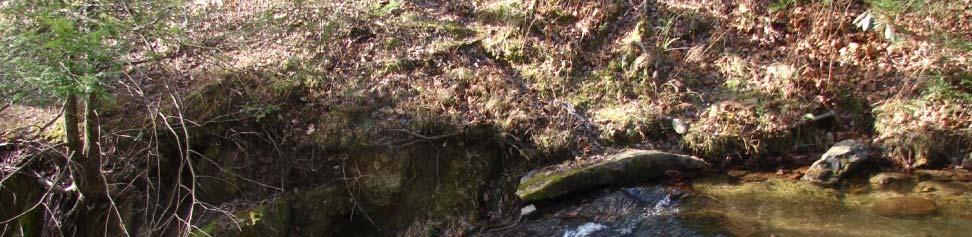
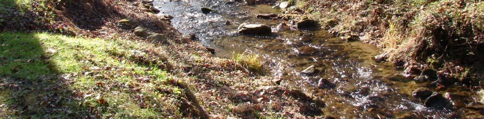
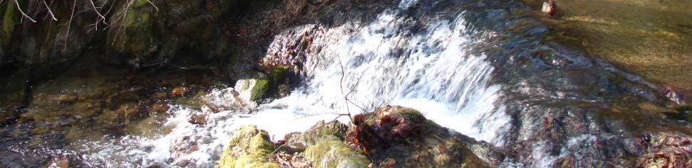
5 Photo #1 Vented ford crossing. Photo #2 Old fish structure (). Photo #3 Thorps Cr. between and fish barrier, looking downstream. Photo #4 Seasonal Fish barrier.


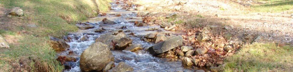
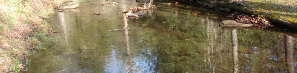
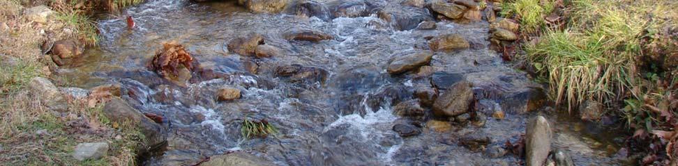
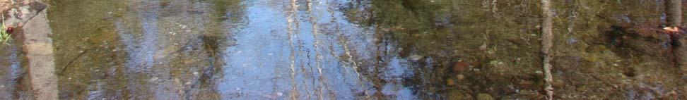
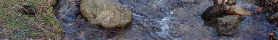
6 Photo #5 Failing crib wall, right bank. Photo #6 crib wall, left bank. Photo #7 Thorps Cr. looking upstream at crib wall & footbridge. Photo #8 Thorps Cr. looking upstream from Hwy 90 culvert.
7 Cross Section A A A A SIDESLOPE LOWER STREAM BANK STABILIZATION THORPS MORTIMER RECREATION AREA PLAN VIEW SKETCH PROPOSED ACTION LAY BACK STREAM BANKS TO A 2:1 SLOPE CHANNEL & SMALL FLOODPLAIN FEATURES MORTIMER WORK CENTER TO VENTED FORD XING BATHROOM HWY 90 FOOTBRIDGE CAMP SITE #2 A TERRACE KIOSK ACCESS ROAD FSR FLOOD DEPOSITION ESTES MILL CR. CONFLUENCE OLD FISH STRUCTURE () A TERRACE SEASONAL FISH BARRIER Proposed Action: 1) Lay back ~ 700 feet of eroding stream bank to a 2:1 (rise:run) slope and replace the footbridge, 2) Remove three old fish structures, 3) Construct up to three log and boulder vanes and two constructed riffles, and 4) Implement erosion control measures, including native seed, straw mulch, coir matting on stream banks, planting trees and shrubs, and installing split rail fence for long term stabilization. A medium sized trackhoe shall be used, along with a dump track truck in the construction of this project. All disturbed area shall be seeded and mulched. 5) At the existing FSR 116 crossing of Thorps Creek, remove the vented ford crossing and install a crossing designed to pass fish. This part of the project would be accomplished using funds other than Watershed Condition Improvement funding. FLOODPLAIN TERRACE KEY: = log & boulder vane = constructed riffle = bank sloping = pool habitat PARTIAL FISH PASSAGE BARRIER DUE TO 1 DROP & HIGH VELOSITY THRU PIPE
8 STREAM BANK STABILIZATION THORPS MORTIMER RECREATION AREA ESTIMATED COSTS Description Quantity Unit Unit Price Totals ITEM 1. MORTIMER REC. AREA - Thorps CREEK WATERSHED IMPROVEMENT PROJECT 1A. EQUIPMENT & LABOR Track hoe w/ hydraulic thumb & operator 75 hours $130 $9,750 Mobilization 1 each $1,500 $1,500 Dump track-truck w/ operator 10 hours $100 $1,000 1B. MATERIALS Furnish boulders for Vanes (40 each) & Riffles (60 each) 100 ton $50 $5,000 Furnish and install nonwoven geotextile in log vanes 40 square yard $6 $240 1C. EROSION & SEDIMENT CONTROL Furnish & install silt fence 200 linear feet $4 $800 Seed & mulch all disturbed soil 1000 square yard $2 $2,000 Furnish & install riparian planting (bare root) 300 each $5 $1,500 Furnish & install coir mat 700 (includes live staking) 400 square yard $10 $4,000 Estimated Contract Cost: $25,790 ADMINISTRATION NEPA - EA 1 each $4,700 $4,700 Design & Inspection of Contract 20 days $390 $7,800 Estimated Admin. Cost: $12,500 GRANDFATHER DISTRICT FORCE ACCOUNT Furnish & install split-rail fence 1000 linear feet $10 $10,000 Estimated Force Account Cost: $10,000 Total Costs: $48,290
Stream Restoration: Working with Nature?
 Stream Restoration: Working with Nature? Greg Jennings, PhD, PE jenningsenv@gmail.com Ecosystem Restoration activities that initiate or accelerate the recovery of ecosystem health, integrity, and sustainability
Stream Restoration: Working with Nature? Greg Jennings, PhD, PE
 Stream Restoration: Working with Nature? Greg Jennings, PhD, PE jenningsenv@gmail.com Ecosystem Restoration activities that initiate or accelerate the recovery of ecosystem health, integrity, and sustainability
Department of Agriculture. Conservation Service. United States. Natural Resources REVISED 8/26/16
 GENERAL NOTES: SYMBOL LEGEND 1. All work shall comply with the constriction specifications, drawings, project-specific quality assurance plan and other contract requirements. 2. All notes on the drawings
Guiding Landowners in Stream Restoration. The Science, Practice & Art of Restoring Native Ecosystems 2015
 Guiding Landowners in Stream Restoration The Science, Practice & Art of Restoring Native Ecosystems 2015 January 24, 2015 Guiding Landowners in Stream Restoration January 24, 2015 Agenda 1Watershed Planning
Tentatively Selected Plan within Harlem River, East River and Western Long Island Sound Planning Region. First Level Costs. Federal Non-Federal Total
 HARLEM RIVER, EAST RIVER AND WESTERN LONG ISLAND SOUND PLANNING REGION Flushing Bay and Creek Ecosystem Restoration Source Feasibility Study Background Study Resolution (1994), Reconnaissance Report (1996),
Construction Progress Report
 Report Date: 4/8/2017 Subject: Construction Week 2 70% Complete Project: Sunset Pond EWP Stream Reclamation, Fourmile Creek, Boulder County, CO Report By: TJ Burr, Civil Engineer/Stream Restoration Specialist,
Urban Conservation Practice Physical Effects ESTABLISHMENT, GROWTH, AND HARVEST NUTRIENT MANAGEMENT
 NOT WELL 800 - Urban Stormwater Wetlands A constructed system of shallow pools that create growing conditions for wetland plants to lessen the impacts of stormwater quality and quantity in urban areas.
Is a Riparian Restoration Still Viable After 100-year Storm Events Alter the Original Design?
 Is a Riparian Restoration Still Viable After 100-year Storm Events Alter the Original Design? Sarah Spear Cooke, Ph.D. Seattle, Washington Presentation Outline Introduction The site pre-restoration Restoration
Banking on Natural Fibers Products made from coir and jute play a key role in stabilizing a restored stream for a commercial stream mitigation bank.
 Banking on Natural Fibers Products made from coir and jute play a key role in stabilizing a restored stream for a commercial stream mitigation bank. By Greg Northcutt When White Creek Mitigation, LLC,
Working with nature to manage your stream
 Working with nature to manage your stream Issued by Auckland Council March 2013 If you have any questions about this information sheet please contact Auckland Council on 09 301 0101 A stream in a property
STREAM ALTERATION PRACTICES
 STREAM ALTERATION PRACTICES Stream Diversion Channel SDC DEFINITION A temporary channel constructed to convey stream flow around in-stream construction. PURPOSE Stream diversion channels are used to allow
Lake and Stream Restoration Project
 Pre-project Fact Sheet May 2012 Toledo Botanical Garden (TBG) is a 60 acre public garden visited by more than 120,000 people annually. It is located in Toledo, Ohio in the Ottawa River watershed within
Town of Essex Small Site Erosion Control Guide
 Town of Essex Small Site Erosion Control Guide Why do we need to protect against erosion? Water Quality: Erosion and the transport of sediment and pollutants impacts the water quality of nearby streams
Colorado Watershed Protection Fund - Project Grant Application Fountain Creek Restoration Shryver Park Reach Including Shryver Pond
 Fountain Creek - Manitou Springs, CO Shryver Park Reach and Pond Restoration Project Submitted by: The Fountain Creek Restoration Committee & The Pikes Peak Community Foundation April 28, 2008 FCRC Page
Presentation to Parks and Open Space Advisory. Committee September 22, 2016
 Flood Planning & Preliminary Design Services for South St. Vrain Creek Restoration at Hall Ranch Presentation to Parks and Open Space Advisory Prepared for: Boulder County, Colorado Committee September
2014 HDR 2014 Architecture, HDR, Inc., all all rights reserved. reserved.
 2014 HDR 2014 Architecture, HDR, Inc., all all rights reserved. reserved. Uplift of a Wet Weather Stream: Satisfying Regulatory Requirements Agawela Drive Stream Project Chattanooga, TN 2014 HDR, Inc.,
Erosion Control for Home Builders in the. City of Jacksonville
 Erosion Control for Home Builders in the City of Jacksonville Eroding construction sites are a leading cause of water quality problems in Jacksonville. For every acre under construction, about a dump truck
Shelbyville, KY Stormwater Best Management Practices. Section 2 EROSION PREVENTION AND SEDIMENT CONTROL PLAN
 Section 2 EROSION PREVENTION AND SEDIMENT CONTROL PLAN 2.1 Requirements The City of Shelbyville, KY will require an Erosion Prevention and Sediment Control (EPSC) Plan for most types of development construction.
North Branch of Cypress Creek Ecological Restoration: A Comprehensive Approach to Stream Restoration
 North Branch of Cypress Creek Ecological Restoration: A Comprehensive Approach to Stream Restoration Rocky Powell Clear Creeks Consulting, LLC Keith D. Tate, P.E. BayLand Consultants & Designers, Inc.
2011 ASLA Design Awards. Coyote Gulch Honor Award and Land Stewardship Designation Valerian LLC. Environmental Restoration and Reclamation
 2011 ASLA Design Awards Honor Award and Land Stewardship Designation Valerian LLC Environmental Restoration and Reclamation Project Name: Category : Project Location: 5 2011 Environmental Restoration and
Attention: Ray Tardiff,
 D B 1A 1750 S.Quinn Prince George, B.C. V2N 1X3 PHONE: (250) 562-5541 FAX: (250) 562-5561 E-MAIL: dwbpg@mag-net.com August 30, 2007 PC: MOF-05-001 Ray Tardiff, Regional Roads Specialist Ministry of Forest,
Kootenai River Habitat Restoration Program June 18, 2018 Kootenai Valley Resource Initiative Update
 Kootenai River Habitat Restoration Program June 18, 2018 Kootenai Valley Resource Initiative Update Kootenai River Habitat Restoration Program Multi-year habitat restoration program Restoration treatments
WETLAND SOD u Bare Root Wetland Plants u Deep Rooted Willows u Coir Logs u Native Trees & Shrubs u Habitat Islands u Custom Growing
 WETLAND SOD u Bare Root Wetland Plants u Deep Rooted Willows u Coir Logs u Native Trees & Shrubs u Habitat Islands u Custom Growing 2009 PROJECT HIGHLIGHTS The following 10 projects highlight the interesting
MINNEHAHA GLEN FEASIBILITY STUDY
 THE KESTREL DESIGN GROUP, INC. 2007 Prepared for: Prepared by: Minnehaha Creek Watershed District Minneapolis Park and Recreation Board The Kestrel Design Group, Inc. Wenck Associates ISSUES AND STRATEGIES:
Illinois Urban Manual
 Illinois Urban Manual Jim Nelson: Association of Illinois Soil and Water Conservation Districts (AISWCD) Funding for this project provided, in part, by the Grand Victoria Foundation of Elgin IL, the Governor
5. LOW IMPACT DEVELOPMENT DESIGN STANDARDS
 5. LOW IMPACT DEVELOPMENT DESIGN STANDARDS Low Impact Development (LID) requires a shift in stormwater management away from conveying runoff to a small number of downstream points through hydraulically
Appendix E Preliminary Design
 Appendix E Preliminary Design 1 1 0+080 0+100 0+200 0+240 LEGEND PROPOSED POOL PROPOSED RIFFLE PROPOSED COIR CLOTH BANK TREATMENT PROPOSED VEGETATED STONE BANK TREATMENT PROPOSED VEGETATED BLOCK BANK TREATMENT
Appendix N. Preliminary Design
 Appendix N Preliminary Design Belfountain Dam and Headpond Class EA Preferred Alternative D4H5: Lower the spillway & backfill headpond & construct channel Preliminary Cost Estimate ITEM ITEM UNIT EST.
Jill Stachura STORMWATER BMP AND STREAM RESTORATION IN A CITY PARK. October 2013 Southeast Stormwater Association Annual Conference, Charlotte, NC
 Jill Stachura STORMWATER BMP AND STREAM RESTORATION IN A CITY PARK October 2013 Southeast Stormwater Association Annual Conference, Charlotte, NC Project Location Gwinnett County, GA: Population: 825,000
Guidelines for Streambank Protection
 PDHonline Course C187 (3 PDH) Guidelines for Streambank Protection Instructor: John Poullain, PE 2012 PDH Online PDH Center 5272 Meadow Estates Drive Fairfax, VA 22030-6658 Phone & Fax: 703-988-0088 www.pdhonline.org
Old Mill Community Association Bioretention Facility
 Project Overview This project will install a bioretention facility in a community recreation area owned by the Old Mill Community Association, Inc. Drainage from the area is currently unmanaged and has
Managing Erosion. What is erosion? Types of erosion. A guide for managing and preventing erosion on your farm
 Managing Erosion A guide for managing and preventing erosion on your farm A gully at Greta West fenced and revegetated approximately 15 years ago with a mix of native trees and shrubs. The waterway is
Donaldson Run Tributary B Stream Restoration Project Update. February 23, 2011 Taylor Elementary School
 Donaldson Run Tributary B Stream Restoration Project Update February 23, 2011 Taylor Elementary School Big picture concepts Past land use and drainage decisions have severely impacted County streams Watershed
River Restoration Practices:
 River Restoration Practices: Comparison of British Columbia and Central European Practices by David Matsubara and Dave Murray Add Map of North America VANCOUVER, Wa. Add Map of Vancouver OUTLINE Introduction
Lilburn, GA STORMWATER BMP AND STREAM RESTORATION IN A CITY PARK. July 2013 Jill Stachura
 Lilburn, GA STORMWATER BMP AND STREAM RESTORATION IN A CITY PARK July 2013 Jill Stachura Project Location Gwinnett County, GA: Population: 825,000 Area: 437 sq. miles 1,300 miles storm drainage system
Riparian Buffer on the Bushkill Creek. Policies
 Riparian Buffer on the Bushkill Creek Riparian buffers provide numerous benefits to landowners and the community by protecting groundwater recharge areas, providing flood control, providing stormwater
Information for File # JTF
 Information for File # 2013-04665-JTF Applicant Corps Contact Enbridge Energy, Limited Partnership Josh Fitzpatrick Address 1554 Highway 2, Suite 2, Two Harbors, MN 55616 E-Mail joshua.t.fitzpatrick@usace.army.mil
INTER-AGENCY COORDINATION MEETING
 Virginia Department of Transportation INTER-AGENCY COORDINATION MEETING Joint Permit Application DEQ COE VMRC I. VDOT PROJECT INFORMATION PERMIT #: PRE-APP#: Route: VDOT Project Number: City/County: Contract
The Napa River Flood Protection Project
 The Napa River Flood Protection Project Creating Flood Protection and Restoring Geomorphic and Biological Processes Jeremy Sarrow, Napa County Flood Control & Water Conservation District June 2, 2014.
SECTION 6. Routine Maintenance Activity Details
 SECTION 6 Routine Maintenance Activity Details 80. DEBRIS REMOVAL When Deadfall, and other objects, such as shopping carts, tires, appliances, and mattresses have accumulated in the drain. Why To prevent
Wallkill River. Floodplain Bench Project Phase 1. OCSWCD Kevin Sumner. October 2016 Orange County. Wendell Buckman
 Wallkill River Floodplain Bench Project Phase 1 October 2016 Orange County OCSWCD Kevin Sumner Wendell Buckman Introduction Location Define the Problem History Location MIDDLETOWN NEWBURGH PROJECT Location
Rule D Wetland and Creek Buffers
 Rule D Wetland and Creek Buffers 1 Policy It is the policy of the Board of Managers to ensure the preservation of the natural resources, recreational, habitat, water treatment and water storage functions
BASS PONDS, MARSH, & WETLAND HABITAT RESTORATION PROJECT
 FACT SHEET BASS PONDS, MARSH, & WETLAND HABITAT RESTORATION PROJECT MINNESOTA VALLEY NATIONAL WILDLIFE REFUGE, MINNESOTA ENVIRONMENTAL MANAGEMENT PROGRAM LOCATION Three areas located on the Minnesota Valley
EROSION & SEDIMENT CONTROL
 EROSION & SEDIMENT CONTROL Surface Water Protection During Well Site Construction Kelly Kees, PE WVDEP, Office of Oil and Gas SEDIMENT & EROSION CONTROL PLANS Per West Virginia State Code 22-6-6(d) 22-6A-7(c),
UPPER SLIGO CREEK: FLORA LANE TRIBUTARY- AMERICAN EEL HABITAT RESTORATION PROJECT
 UPPER SLIGO CREEK: FLORA LANE TRIBUTARY- AMERICAN EEL HABITAT RESTORATION PROJECT -Background Fish Habitat t and Restoration ti 1994 - M-NCPPC, MCDEP and COG constructed a stormwater parallel pipe and
DITCH BANK STABILIZATION TECHNIQUES
 onstructed Ditch Drainage anagement Guide - No. 0 in series Order No. 5.0- December 00 DITH BANK STABILIZATION TEHNIQUES It is important to maintain ditches using practices that ensure ditch banks remain
FirstLight Power Shoreline Management Manual Sustainable Shoreline Designs: From Long Island to Lake Erie Webinar Series
 FirstLight Power Shoreline Management Manual Sustainable Shoreline Designs: From Long Island to Lake Erie Webinar Series Presented by Jason Williams, PLA, NCI February 19, 2017 Introduction Lakes (impoundments)
Design and Installation of Embedded Culverts
 Kamloops March 12, 2002 Pilot 2 Design and Installation of Embedded Culverts Part 2: Design 1 2 Part 2: Design 6 Main Topics 1. Evaluation of site suitability 2. Detailed streambed profile 3. Sizing the
Pike River Restoration Adaptive Design: Restoring Structure and Function in an Urban Floodplain - from cabbages to cordgrass
 Pike River Restoration Adaptive Design: Restoring Structure and Function in an Urban Floodplain - from cabbages to cordgrass Alice Thompson, PWS & Heather Patti, PWS Pike River Re-imaginedfrom Cabbage
Structural Storm Water Best Management Practices (BMPs)
") Structural Storm Water Best Management Practices (BMPs) Storm Water Permitting: The SWPPP Revealed By Deron Austin, PE January 11, 2006 3:30-5:00 PM Orlando, Florida Presentation Outline Preface About
Structural Storm Water Best Management Practices (BMPs) Storm Water Permitting: The SWPPP Revealed By Deron Austin, PE January 11, 2006 3:30-5:00 PM Orlando, Florida Presentation Outline Preface About
Chapter 11 Site Rehabilitation and Stabilization
 Chapter 11 Site Rehabilitation and Stabilization Chapter 11 Layout: Part 1 - Page 131 Planning Site Rehab Part 2 - Page 132 Controlling Runoff and Capturing Sediment Part 3 - Page 133 Rehab for Crossings
Restoration in the Sky Islands:
 Restoration in the Sky Islands: Bringing volunteers, landowners, practitioners and agencies together to benefit wildlife and habitats in a global biodiversity hotspot Sky Island Alliance Dedicated to the
HYDRAULIC DESIGN involves several basic
 Chapter 6 Tools for Hydr draulic and Road Design HYDRAULIC DESIGN involves several basic concepts that must be considered to build successful projects with a minimum risk of failure (Photo 6.1). Use of
Project: Developer/Designer: Reviewer: I. Narrative: 1. Project Description: Describes the nature and purpose of the land disturbing activity.
 City of Charlottesville, Virginia Erosion and Sediment Control Plan Review Checklist 610 East Market Street, Charlottesville, VA 22902 Telephone 434-970-3182; Fax 434-970-3359 Project: Developer/Designer:
Section 3 Non-Structural BMPs
 3.1 Stream Buffers A stream buffer or stream setback is a designated area around a stream, lake, or wetland left in a natural, densely vegetated state so as to protect the receiving water quality and provide
Stormwater BMP and Stream Restoration in a City Park. Jeff Herr P.E., D.WRE Jill Stachura
 Stormwater BMP and Stream Restoration in a City Park Jeff Herr P.E., D.WRE Jill Stachura 770.673.3673 JHerr@BrwnCald.com Project Location Camp Creek in Metro Atlanta 7 sq. mile drainage area at project
Single most pervasive problem: Polluted runoff from watershed development
 What are Some Potential Threats to Maine s Lakes Acid rain Mercury contamination Aquatic Invaders: The Milfoil threat Loss of critical habitat Global climate change Single most pervasive problem: Polluted
OPPORTUNITIES AND CONSTRAINTS - OXBOW PARK ENTRANCE AND PUT-IN
 OPPORTUNITIES AT OXBOW EXISTING WETLANDS Site is undeveloped and we can design a park that works well from the start. SAND BEACH Potential to eliminate invasive species. DEBRIS (CONCRETE, OLD CARS) VEGETATION
Coir Fibers Help Strengthen Environmentally-Friendly Golf Course Stream Restoration Project
 Coir Fibers Help Strengthen Environmentally-Friendly Golf Course Stream Restoration Project RoLanka International, Inc. 2004 Stabilizing nearly two miles of streambanks and slopes wasn t the only challenge
Royal River Youth Conservation Corps
 Royal River Youth Conservation Corps 2007 Summary Report What s Inside: Contributing Partners Introduction Summary of Accomplishments Map of Sites Descriptions and Photos of Work Completed in: Auburn Durham
SECTION 5: REACH RECOMMENDATIONS/MAPS
 SECTION 5: REACH RECOMMENDATIONS/MAPS This section describes areas of concern and provides specific recommendations for each project reach. Locations of stormwater drains were from GIS coverage supplied
M-231 and Water Quality. Ottawa County Water Quality Forum November 21, 2016 James Fortney, MDOT
 M-231 and Water Quality Ottawa County Water Quality Forum November 21, 2016 James Fortney, MDOT M-231 Facts: 7-Miles long 2-Lane Limited Access Highway Connects I-96 and M-45 M-231 Facts: Includes Michigan
Stormwater Standards. Clackamas County Service District No. 1. Planting Guide for Buffers
 Stormwater Standards Clackamas County Service District No. 1 APPENDIX B Planting Guide for Buffers Table of Contents Appendix B - Planting Guide for Buffers... Page B.1 General... 1 B.1.1 Introduction...
PICTURE CANYON Planning Riparian-Wetland Refugia in an Urban Setting
 PICTURE CANYON Planning Riparian-Wetland Refugia in an Urban Setting Rio De Flag Existing Conditions. Ephemeral stream; Limited riparian plants, habitats.. & Opportunities Water (effluent) available Restore
Alternatives Analysis Summary Memorandum
 F 16253 Swingley Ridge Rd, Suite 100, St. Louis, MO 63017 636-777-3000 P 314.432.5812 F Alternatives Analysis Summary Memorandum To: City of Creve Coeur, Missouri By: Mark Meyer, PE Date: 09-25-2013 Re:
Case Study 6. Fitzpatrick Creek Cable Concrete Block Mat Ford
 Case Study. Fitzpatrick Creek Cable Concrete Block Mat Ford Location Southwest Oregon. Bureau of Land Management Coos Bay District. Fitzpatrick Creek. BLM road 23-8-11.0. This ford was constructed in 2000
ADOPTED CAPITAL IMPROVEMENT PROGRAM BUDGET ARROYO PROJECTS
 ADOPTED CAPITAL IMPROVEMENT PROGRAM BUDGET ARROYO PROJECTS HAHAMONGNA FY 212-216 Capital Improvement Program Priority Description Total Estimated Costs Appropriated Through FY 211 Adopted FY 212 FY 213
Vegetated Filter Strips and Buffers
 3.15 Sediment Control Description: Buffer strips (existing vegetation) and filter strips (planted vegetation) are sections of vegetated land adjacent to disturbed areas. They are designed with low slopes
Urban Water Management (ESRM 311 & SEFS 507) Cougar Mtn Regional Wildland Park & Lakemont Blvd, Bellevue WA
 Cougar Mtn Regional Wildland Park & Lakemont Blvd, Bellevue WA") Urban Water Management (ESRM 311 & SEFS 507) Cougar Mtn Regional Wildland Park & Lakemont Blvd, Bellevue WA Lecture Today Urban Water management terms Examples of water management in urban areas Field
Urban Water Management (ESRM 311 & SEFS 507) Cougar Mtn Regional Wildland Park & Lakemont Blvd, Bellevue WA Lecture Today Urban Water management terms Examples of water management in urban areas Field
Town of Vershire Road Erosion Inventory Report
 Town of Vershire Road Erosion Inventory Report Taylor Valley Road. Photo taken by TRORC staff. Prepared by: 128 King Farm Road Woodstock, VT 05091 Inventory and report funded by the Vermont Agency of Transportation
RECONNECTING A COMMUNITY TO THE CREEK
 RECONNECTING A COMMUNITY TO THE CREEK 0 The J.J. Seabrook Stream Restoration, Rain Garden, and Urban Trail Project Kristin K. Pipkin, P.E. Michelle Adlong, EI.T. TXSER/TRA Joint Conference November 2,
Big Thompson River Restoration Master Plan. Stakeholder Kick off Meeting and Workshop April 12, 2014
 Big Thompson River Restoration Master Plan Stakeholder Kick off Meeting and Workshop April 12, 2014 AGENDA 1:30 to 2:10 Information 2:10 to 2:35 Questions 245t 2:45 to 4:00 400 Worksession in Cafeteria
BE WATER WISE. Managing Your Onlot Stormwater. Sept. 23, 2006 Watershed Weekend
 BE WATER WISE Managing Your Onlot Stormwater Sept. 23, 2006 Watershed Weekend 2006 1 All water resources are interrelated through the Hydrologic Cycle Sept. 23, 2006 Watershed Weekend 2006 2 What is Storm
How to Update a Storm Water Management Program (SWMP) to Incorporate Total Maximum Daily Load (TMDL) BMPs
 to Incorporate Total Maximum Daily Load (TMDL) BMPs") How to Update a Storm Water Management Program (SWMP) to Incorporate Total Maximum Daily Load (TMDL) BMPs Janine Rybka Cuyahoga Soil & Water Conservation District About Habitat Habitats are the places
How to Update a Storm Water Management Program (SWMP) to Incorporate Total Maximum Daily Load (TMDL) BMPs Janine Rybka Cuyahoga Soil & Water Conservation District About Habitat Habitats are the places
Boardman River Watershed VILLAGE OF KALKASKA. WATER QUALITY ACTION PLAN Fall 2009
 Boardman River Watershed VILLAGE OF KALKASKA WATER QUALITY ACTION PLAN Fall 2009 Partners: The Watershed Center Grand Traverse Bay Northwestern Michigan College - Great Lakes Water Studies Institute Grand
Finger Lakes National Forest. Backbone Horse Camp Water Hydrant Project
 United States Department of Agriculture Forest Service February 2014 Backbone Horse Camp Water Hydrant Project Scoping Information Hector Ranger District Town of Lodi, Seneca County, New York For Information
Stream Corridor Management Plan
 Stream Corridor Management Plan A unified and comprehensive approach to protecting, restoring and managing the Upper Delaware River Graydon Dutcher Delaware County Soil and Water Conservation District
The use of low head weirs to. perennial streams with their floodplains:
 The use of low head weirs to reconnect severely entrenched perennial streams with their floodplains: An Anne Arundel County TMDL Watershed Implementation Plan Strategy presented by Hala Flores, P.E Mid
SUPPORTING DOCUMENT STORMWATER POLLUTION PREVENTION PLAN (SWPPP) NARRATIVE
 NARRATIVE") SUPPORTING DOCUMENT STORMWATER POLLUTION PREVENTION PLAN (SWPPP) NARRATIVE Please complete this narrative form and submit with your SWPPP drawings. Refer to Kitsap County Stormwater Design Manual Vol.
SUPPORTING DOCUMENT STORMWATER POLLUTION PREVENTION PLAN (SWPPP) NARRATIVE Please complete this narrative form and submit with your SWPPP drawings. Refer to Kitsap County Stormwater Design Manual Vol.
Worksheet #14 Water Runoff Management
 Water Runoff Management Use this worksheet to assess how well your property minimizes the potential for water runoff and property damage.. Why should you be concerned? What can you do? Rural runoff, also
GREEN SHEET ENVIRONMENTAL COMMITMENTS FOR THE IOWA HIGHWAY 100 EXTENSION
 County: Linn County, IA GREEN SHEET Location: IA 100, from its terminus at Edgewood Rd. to US 30 southwest of Cedar Rapids Route: IA 100 Extension Project No.: NHS-100-1(36) 19-57 OLE Project Managers:
ENBRIDGE GAS DISTRIBUTION INC. Proposed Relocation for Ninth Line, Markham and Whitchurch-Stouffville. Environmental Screening Report
 Page 1 of 18 ENBRIDGE GAS DISTRIBUTION INC. Proposed Relocation for Ninth Line, Markham and Whitchurch-Stouffville Environmental Screening Report July 2011 Page 2 of 18 Table of Contents 1.0 INTRODUCTION
Buffer Zone (BZ) Stream Protection. The width and plant composition of a buffer zone will determine its effectiveness.
 Stream Protection. The width and plant composition of a buffer zone will determine its effectiveness.") Buffer Zone (BZ) Figure BZ-1 Buffer Zone in Agricultural Area Practice Description A buffer zone is a strip of plants adjacent to land-disturbing sites or bordering streams, lakes, and wetlands that provides
Buffer Zone (BZ) Figure BZ-1 Buffer Zone in Agricultural Area Practice Description A buffer zone is a strip of plants adjacent to land-disturbing sites or bordering streams, lakes, and wetlands that provides
Town of Lyons Parks Flood Recovery Planning Process. Photograph courtesy of Ed Bruder
 Town of Lyons Parks Flood Recovery Planning Process Photograph courtesy of Ed Bruder Lyons Parks and Recreation Flood Recovery Update 1. Meadow Park Phase II - Project PW20B1 Estimated Completion: Summer
STREAM BUFFERS
 88-415 STREAM BUFFERS 88-415-01 PURPOSE In the Kansas City region and throughout the nation, vegetated stream buffers have been clearly shown to protect stream stability and related infrastructure, improve
Donaldson Run Tributary B Stream Restoration Project Update. Donaldson Run Stakeholder Advisory Group Meeting June 2, 2011
 Donaldson Run Tributary B Stream Restoration Project Update Donaldson Run Stakeholder Advisory Group Meeting June 2, 2011 Review of changes from 30% to 60% design Reducing width of channel/floodplain to
MCCOYS CREEK RESTORATION 30% DESIGN
 MCCOYS CREEK RESTORATION 30% DESIGN THE MCCOYS CREEK RESTORATION PLAN The restoration plan aims to reduce flooding, restore ecosystem health, expand recreational opportunities along the creek, and connect
Analyzing the Bioretention Construction Sequence
 Analyzing the Bioretention Construction Sequence Avoiding future problems through careful installation procedures, construction inspection and first year maintenance 20 Steps to Better Bioretention Step
HOW TO CONTROL STREAMBANK EROSION
 6 HOW TO CONTROL STREAMBANK EROSION Prepared by the Iowa Department of Natural Resources In cooperation with the Natural Resources Conservation Service, U.S. DEPARTMENT OF AGRICULTURE 2006 The 1984 printing
Design Considerations for Open Channel and Detention Pond Design. Howard Redfearn, City of Mansfield
 Design Considerations for Open Channel and Detention Pond Design Howard Redfearn, City of Mansfield Previous Experience/Criteria/Maintenance Issues New Criteria Discussion Overview Where is Mansfield?
The Development of Riparian Stream Buffers in Greensboro, NC
 The Development of Riparian Stream Buffers in Greensboro, NC Why our stream banks have grown up? Presented by: Peter Schneider, Water Quality Supervisor City of Greensboro Stormwater Management Division
Geosynthetics for Erosion Control and Reinforcement
 Geosynthetics for Erosion Control and Reinforcement Stan Boyle, Ph.D., P.E. Shannon & Wilson, Inc. What are Geosynthetics? Geosynthetics are (generally) polymeric products used in civil engineering applications.
Vegetated Filter Strips and Buffers
 3.15 Sediment Control Description: Buffer strips (existing vegetation) and filter strips (planted vegetation) are sections of vegetated land adjacent to disturbed areas. They are designed with low slopes
Using the Updated RI Soil Erosion and Sediment Control Handbook. The Introductory Workshop for RIDEM/CRMC Staff January 23, 2015
 Using the Updated RI Soil Erosion and Sediment Control Handbook The Introductory Workshop for RIDEM/CRMC Staff January 23, 2015 URI Cooperative Extension NEMO URI Cooperative Extension NEMO White Oak,
City of Stoughton Erosion Control Permit Application (effective 2/6/2018)
") City of Stoughton Erosion Control Permit Application (effective 2/6/2018) Incomplete applications will not be accepted Project Name: Address of subject property: Landowner Name(s): Applicant Name: Landowner
City of Stoughton Erosion Control Permit Application (effective 2/6/2018) Incomplete applications will not be accepted Project Name: Address of subject property: Landowner Name(s): Applicant Name: Landowner
Report prepared by USDA Natural Resources Conservation Service and the Coastal San Luis Resource Conservation District
 Morro Bay Watershed Partners in Restoration Permit Coordination Program Report prepared by USDA Natural Resources Conservation Service and the Coastal San Luis Resource Conservation District In fulfillment
Cedar Niles Future Park Site Wetland #1
 Date: October 20, 2014 Site: Landowner: Johnson County Parks Designer: Thomas R. Biebighauser Individuals Present: Thomas R. Biebighauser, Dr. Eliodora Chamberlain (US EPA), Jason Daniels (US EPA), Jeannette
Preliminary Sketch Plan for Fort Hunter Park
 Preliminary Sketch Plan for Fort Hunter Park Public Presentation November 19, 2009 Dauphin County Parks and Recreation 100 Fort Hunter Road Harrisburg, PA 17110 (717) 599-5188 www.dauphinc.org THOMAS COMITTA
Urban Water Management and Soils (ESRM 311 & SEFS 507)
") Urban Water Management and Soils (ESRM 311 & SEFS 507) Cougar Mtn Regional Wildland Park & Lakemont Blvd, Bellevue WA Lecture Today Some Urban Water management terms Examples of water management in urban
Urban Water Management and Soils (ESRM 311 & SEFS 507) Cougar Mtn Regional Wildland Park & Lakemont Blvd, Bellevue WA Lecture Today Some Urban Water management terms Examples of water management in urban
USING PLANTS TO STABILIZE STREAM BANKS
 USING PLANTS TO STABILIZE STREAM BANKS This handout is intended to provide you with a general orientation to the three most common and practicable soil-bioengineering techniques. In a number of situations,