PARK, RECREATION AND TRAIL PLAN
|
|
|
- Bertram Todd
- 5 years ago
- Views:
Transcription
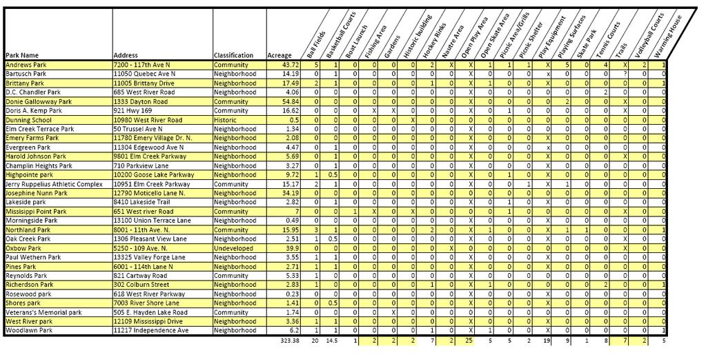
1 4.1 EXECUTIVE SUMMARY The Comprehensive Park, Recreation, and Trail Master Plan establishes the vision for the park system including maintenance, renovation and enhancement. The plan concludes that the park system is essentially complete in terms of acreage (323 acres) and basic facilities. The needs of the park system identified by the community were primarily in the area of quality rather than quantity of parks and facilities. Champlin has 30 parks comprised of 295 acres and 17.5 miles of offroad trails throughout the community. The parks and trails provide a wide range of recreational opportunities to Champlin residents, area employees and visitors. Champlin s trail system is a combination of off-road, on-road and internal park trails. An inventory of existing parks showing recreational facilities is attached as Table 4-1. Improvements to the park system will be made incrementally each year. Specific improvement projects are identified and prioritized within this plan and as a part of the overall Capital Improvement Plan (CIP). The CIP is a planning document and is subject to change depending upon overall City priorities and the funding available. The City of Champlin has a park system with an approximate value of $9,000,000, which does not include the value of the land. To properly maintain and replace equipment and facilities the City should consider budgeting $350,000 per year to help meet the depreciation of the existing facilities and this amount should increase annually due to inflation each year. As new facilities are added this investment must increase proportionately. The City and the School District should work cooperatively and consider sharing financial responsibility to improve and maintain the outdoor facilities at Jackson Middle School. This investment will allow organized youth athletics to continue to provide adequate programming to meet the growing needs of the community. The investment in existing facilities should be made prior to developing additional facilities and is needed for safety and usability rationale. The City has positioned itself to address playground equipment safety and accessibility concerns by implementing a Playground Equipment Replacement Plan. This plan systematically layouts how the City will proceed with replacing equipment in the City to meet safety and accessibility concerns of existing playground equipment facilities. 4-1
2 The City has positive relationships with youth athletic organizations and service organizations such as the Champlin American Legion and the Champlin Lions. These partnerships, which include human resource and financial resource sharing, will continue to help make improvements to the park and recreation system at a greater pace than if the City progressed by itself. The City currently has approximately 17.5 miles of off-road trails in the community. This plan outlines the potential of an additional 21 miles of off-road trail as the remaining portions of the City develop. The City will need to continue to work with developers as new developments are proposed to help connect these developments to the existing amenities in the community. Possibly the most important issue facing the City and its park and recreation system is to find adequate funding to improve existing facilities to help meet increased demands. Funding of the system can be accomplished through additional allocations from the General Fund, partnerships with service organizations, actively pursuing grant opportunities, and the potential development of a Community Foundation that would allow tax free donations to the park and recreation system. 4.2 INTRODUCTION The City of Champlin has the framework for a quality park and recreation system. Parks, trails and open spaces are important to residents. Parks define neighborhoods, offer recreation opportunities, and serve as open space and wildlife habitat. Champlin s parks act as neighborhood gathering points and strengthen the sense of community. Champlin is committed to meeting its resident s needs and will plan wisely for the future. As such, this plan is designed to help continue the tradition of quality parks, recreation and trails. It is Champlin s intent to provide passive and active recreational opportunities through well-balanced parks and facilities. This document updates the Comprehensive Parks system and Recreation Plans that were approved in 1978, 1981 and 1995 and The general intent of the plan is to provide an analysis and decision making framework comprised of definitions, standards, and policies. The application of these planning tools is intended to provide the method to evaluate the existing parks and trails system and predict future needs which should result in the preservation of open 4-2
3 space and the development of parks facilities and recreation programs designed to meet the recreational needs of the residents of Champlin. This master plan will be the benchmark policy document for the City s service delivery. This will be our blueprint for decision making because it determines the fundamental services to be provided and commits the City to specific strategies for allocating resources. Parks and Recreation shall: Provide social benefits by connecting people with neighbors of other ages, incomes, backgrounds and abilities. Parks and recreation can build community pride and spirit. Provide economic benefits by improving the quality of life in the city and help attract business and residents. Top-rate parks and recreation programs and facilities can be a competitive advantage for Champlin in economic development. Provide benefits to the environment by connecting people with and educating them about nature. In addition, greenways can provide alternative transportation opportunities. Provide benefits to individuals by promoting physical fitness and self-improvement. Opportunities for exercise and being outdoors result in greater physical fitness, emotional well being and connectivity to nature. The Parks, Recreation and Trail Plan contains six sections. 1. Section One provides a summary of the planning and public input process. 2. Section Two contains Community Characteristics, such as a summary of existing parks, the regional setting, a list of major stakeholders, partners and growth forecast. 3. Section Three outlines the Park and Trail System Framework. This includes park and trail classifications, recreation facility standards and park service area criteria. These standards are used in assessing community needs and planning the future park system. 4-3
4 4. Section Four is a Needs Assessment and Recommendations analysis. The majority of this information pertains to the renovation and redevelopment of our existing park system but also includes development of some park space and trail connections. 5. Section Five pertains to Parks, Recreation, Trails and Open Space Goals and Policies. This section will help the community make decisions on how to best use and provide for the park and recreation system. 6. Section Six is the Implementation section, which will outline strategies and funding plans to help provide the essential elements of the overall Comprehensive Park, Recreation & Trail Master Plan. SECTION COMMUNITY INPUT PROCESS The City of Champlin was interested in feedback regarding this park plan. The City wanted the plan to represent the community s needs and desires. That goal resulted in a commitment to gather extensive public and user input about desires for the existing and future park system needs. Over a several month process, the City gathered information from a wide variety of sources that have influence over or have a stake in Champlin s Parks and Recreation. The following sources were used to provide insight relevant to issues associated with growth and parks, open space, trails and recreation in Champlin. Park and Recreation Commission - The Champlin Parks and Recreation Commission oversaw preparation of the plan. The Commission worked with city staff and the community and provided guidance and input. Their continued energy and commitment will be instrumental as they guide park and recreation, renovation and development in the future. City Staff - City staff visited each park and many trail corridors to map and document existing conditions and to plan for future improvements. City park management, programming, maintenance, planning, engineering and community development staff participated in the plan preparation or review. Public Opinion Survey - In 2007, Decision Resources Inc., conducted a public opinion phone survey of Champlin residents. The survey 4-4
5 included questions about recreation facility use, satisfaction and priorities for the future. Focus Group Meetings - Focus group sessions were held with user and stakeholder groups to gather input about the City s future growth and the possible implications of that growth to each focus group and to Champlin s Parks, Trail and Recreation program. The focus groups included the Champlin Dayton Athletic Association (CDAA), Champlin Park Youth Hockey Association (CPYHA), Champlin Dayton Rebels Soccer Club (CDSC), Champlin Senior Club, Champlin Historical Society and Community Education (Anoka Hennepin School District 11). SECTION COMMUNITY CHARACTERISTICS Champlin is bordered by the Mississippi River and the City of Anoka to the north, the City of Dayton to the west, and the Cities of Maple Grove and Brooklyn Park to the South. Three Rivers Park District owns a regional park, Elm Creek Park Reserve, portions of which lie within Champlin s city limits. Elm Creek Park Reserve is designed to provide natural resource based recreation and education opportunities. Three Rivers Park District is the implementing agency for regional trails in and around Champlin. The trail system within the Elm Creek Park Reserve, as well as the Coon Rapids Dam Regional Park, provides miles of regional paved trail opportunities for Champlin residents. Within the city limits, Champlin has three public schools, Champlin Elementary, Parkview Kindergarten Center and Jackson Middle School. Just south of 109 th Avenue lies Champlin Park High School and Oxbow Elementary. The school district has several athletic fields and playgrounds associated with these school sites. The school sites also have tennis courts and gymnasiums. The City and School District have a cooperative relationship for recreation facility planning and development. NATURAL RESOURCES The City is blessed with many natural resources including the Mississippi River to the north, oak savanna, oak woodlands, wetlands, creeks, and small ponds. The Elm Creek Park Reserve has many other 4-5
6 natural resources that help support healthy flora and fauna environments. The City of Champlin is also fortunate to have a section of the Elm Creek that remains in its natural state. The City Council has recently adopted an amendment to Champlin s Comprehensive Plan called the Northwest Vision Plan. The vision for the area hopes to incorporate and protect the natural beauty of the Elm Creek and preserve the area for generations to come. During planning in the northwest area, the City should use specific land use policies and management strategies to preserve the unique character of the Elm Creek and attempt to preserve a linear park along the creek. HISTORIC AND CULTURAL RESOURCES Champlin has a rich history with a strong link to the Mississippi River. The Champlin Historical Society has been able to preserve parts of Champlin s history allowing young and old to enjoy Champlin s story. Two historic buildings (Dunning School, and the Champlin Library) lie on park property and are used to help educate those interested in Champlin s history. Champlin also rehabilitated the old Highway 52 bridge in 2005, which now connects Veteran s Memorial Park to Doris Kemp Park. The bridge was built in 1919 and served two-way vehicular traffic until 1969 when it was closed by City Council Resolution in favor of a divided four-lane highway, which is now Hwy 169. GROWTH FORECASTS By the year 2030, the population of Champlin is predicted to be approximately 27,100. The new residents will create additional demand for municipal services including police, water, sewer, parks, trail, and street maintenance. Population growth is expected to be accommodated in the existing park system. It will be extremely important to properly maintain and care for the existing park system so all residents can gain value from this cherished resource. Trails will be added as development is completed in the northwest area and commercial area in an attempt to connect neighborhoods to existing park and trail amenities. GENERAL RECREATION TRENDS Recreation interests and participation are influenced by many factors. Age, access to facilities, amount of leisure time, interest in the 4-6
7 environment, new recreation technology, social trends all influence recreation participation. In general people are looking for quality recreation close to home, but are willing to travel to obtain better quality or more specialized activities. The following recreation trends have been observed in the Twin Cities area over the last ten years: Trail use has boomed (walking, running, biking and in-line skating) Non-contact recreation activities are growing Soccer participation has increased Most adult team sports participation has plateaued or in some cases declined More youth are specializing in one sport and training year-round Golf has increased in popularity Participation by girls and women in sports has increased Off-leash dog parks are popular Recreation alternatives such as skateboarding, BMX bikes, and climbing are increasing in popularity RECREATION TRENDS IN CHAMPLIN Recreation participation in Champlin will continue to grow as the community grows. The following trends have been noted by City staff and are based upon recent participation and public comments: Increase in trail use Extended seasons of play for baseball, softball and soccer Increased interest in skate boarding and in-line skating Use of outdoor ice has stayed constant Increased requests for park shelter rentals Increased interest in opportunities for Senior Citizens Requests for public meeting room space exceed our capabilities Our Learn to Skate programs continue to be popular Our Adult Softball, Basketball, and Volleyball programs have increased in the last few years but has now leveled off PUBLIC OPINION SURVEY In summary of the 2007 survey by Decision Resources, a strong 81 percent of residents rate the maintenance and condition of City parks and trails as either excellent or good. In discussing a specific facility, 41 percent report members of their household use the Champlin Ice Forum; among Forum visitors, 93 percent rate the facility high. 4-7
8 Twenty-eight percent of the households report members at least occasionally use the pedestrian bridge over Highway 169. Regardless of use, 80 percent think the pedestrian bridge was a wise use of City funds. By a 53 percent to 34 percent margin, residents oppose the use of City funds for a second sheet of ice at the Ice Forum. By a 63 percent to 32 percent margin, respondents favor the use of City funds for an outdoor swimming pool. A virtual tie of 49 percent to 45 percent tips in opposition to more gymnasium space. A virtual tie of 50 percent to 44 percent tips in support of large meeting and/or banquet rooms for uses such as weddings and community events. Ninety-one percent thinks the current mix of City park and recreation programming met the needs of their household. IMPLICATIONS AND FUTURE TRENDS The following are likely trends based on Champlin demographics, user input and the public opinion survey: Trail use will continue to increase and demand for trail expansion and connections between parks and other city locations will grow Individual activities will continue to be as popular as team or group activities Interest in natural resources and open space will grow as the city develops Recreation facility development and operation partnerships between government agencies, schools, and athletic groups will be more important to adequately maintain facilities Seniors will need a place to congregate and be led by a recreational professional knowledgeable in their well being SIGNIFICANT FINDINGS Champlin s population is likely to mature in 2030 at approximately 27,100 residents Most of Champlin s residential growth will occur in the northwest portion of the city Champlin will likely continue to have a high proportion of families with children Partnerships with ISD 11, the business community, youth athletic associations and other service organizations will continue 4-8
9 to be important for a comprehensive and efficient park system in Champlin Champlin will need to significantly increase its financial investment both operationally and with capital investments to maintain a safe and desirable park system Key open spaces and natural resources should be preserved in advance or in concert with development Evaluate the demand and the need for alternative recreational activities Residents are frequent users of Champlin parks and are generally satisfied with the park system; recreation participation will continue to increase SECTION PARK, TRAIL AND OPEN SPACE SYSTEM FRAMEWORK Parks, trails and open space are essential components of a healthy community. Champlin recognizes that provisions of adequate park, recreation, open space and trail connections are essential to the health, safety and welfare of the residents and persons working in the city. Decisions about parks, trails and open space affect the entire community, and if done wisely can help increase quality of life and enhance sense of community. Therefore, it is important to have a set of guidelines to use in decision-making. The following framework was prepared to act as a guide for the preparation of the park plan and for on-going decision making. The framework criteria are based on national standards. Local needs and conditions are equally as important as these minimal standards. As such, this framework should be used as a guide and should be adjusted based on community needs, trends, etc. It is assumed that residents, land developers, city staff, commissions and officials will use this framework and knowledge of local conditions as they face decisions about parks, trails or open space. A typically accepted range of overall park acreage per population is from a minimum of 10-acres/1,000 population to 20 or more acres per 1,000 population. These park acreage figures are for the core park system of mini-parks, neighborhood parks and playfields and community parks and playfields. They do not include trail corridors, greenways, special use parks, school lands, regional parks or conservation areas. This overall figure should be viewed as a 4-9
10 benchmark and should be adjusted based on local needs. The cities average is currently 12.4 acres per thousand residents. 4.6 GENERAL PARK AND TRAIL CRITERIA The following park and trail criteria are applicable to all parks. In addition, the descriptions of each park classification contain specific criteria applicable to that park type. The location of parks and trails will be determined by the city using the park and trail plan as a guide. Parkland shall be suitable to its intended use. This means adequate size, parcel shape, soils, slope, access and relationship to adjacent land uses. Parkland shall be continuous and undivided by roadways, railroad tracks, pipelines, or other impassible or unusable barriers. Parkland shall be free from any contaminants or debris. Trail land shall be of sufficient width and slope to accommodate 10 wide trails and appropriate buffer areas. General guidelines include a minimum width of 20 30, a maximum slope less than 12 percent and an average slope not to exceed four percent. When park land is dedicated, the developer is required to grade the park land and pave access and perimeter trails (not internal park trials) and sidewalks within the park and adjoining rights of way. All construction must meet city specifications. 4.7 PARK AND TRAIL CLASSIFICATIONS Champlin s parks and trails are classified according to their use and function and are described below. MINI PARKS (Rosewood) Mini parks are small parks (0.5 to 2 acres) which are designed to supplement neighborhood parks in specific settings where a neighborhood park is not available or a new neighborhood park cannot be provided. Mini parks typically contain children s play equipment and may also include a small open play area and/or picnic table or seating area. Mini parks typically do not include athletic fields or sports courts. In general mini parks are limited to the following situations: 4-10
11 Additional park land and recreation facilities are needed and suitable land cannot be provided through a neighborhood or community park. Barriers such as major streets or railroads, etc. prevent convenient access to a neighborhood or community park. The presence of high-density residential development warrants additional parkland beyond the typical neighborhood facilities. NEIGHBORHOOD PARKS (Bartusch. Brittany, Elm Creek, Emery, Evergreen, Harold Johnson, Heights, Josephine Nunn, Lakeside, Morningside, Oak Creek, Paul Wethern, Pines, Richardson, Rosewood, Shores, West River Park, and Woodlawn) Neighborhood parks are the core building block of the Champlin Park system. Neighborhood parks are designed to provide the day-to-day recreation facilities for a 125 to 500 acre neighborhood (1/4 to 1/2 mile radius). These parks are designed to serve approximately 300 to 650 households. Neighborhood parks are typically between four and ten acres. The parks typically contain a children s play area, a picnic area, a basketball court, internal park trails, a small parking area and ball fields (softball, baseball, soccer, etc.). Ball fields are typically used for informal use, but they may also be used for youth athletic leagues. Some neighborhood parks may contain a hockey rink, skating area, tennis court or other similar recreation facility. Neighborhood parks may also include natural resources such as wetlands, wooded areas, etc. The following criteria should apply to new neighborhood parks in addition to existing neighborhood parks: Land shall be a contiguous area of 4 to 10 acres and shall have a length/width ratio of no more than 3/1. The parkland should have a minimum of 300 feet of frontage on a public street. At least 240 feet shall be contiguous frontage. The parkland shall have the general qualities needed to allow development of a quality neighborhood park. Land shall be centrally located within a neighborhood and easily accessed by pedestrian or bike. At least 75% of the total area of land shall have a slope of less than or equal to four percent (4%) and shall not be located within a storm water ponding area, drainage way or any other water body. 4-11
12 At least 75% of the total land area shall be of solid sub grade, excluding areas composed primarily of peat or wetland soils. At least 75% of the total land area shall be of well-drained sub soils suitable to support the growth of healthy turf and athletic field use. The park area shall contain a minimum of four inches of topsoil depth and a minimum average depth of six inches and said topsoil shall be of a quality to support establishment of healthy turf and landscaping. NEIGHBORHOOD PLAYFIELDS Neighborhood playfields serve a dual function of providing recreation for neighborhoods and providing facilities for organized youth athletics. Neighborhood playfields have similar facilities as a neighborhood park, but they typically have multiple fields for youth athletic leagues. The playfields are typically larger than neighborhood parks and serve an area of between 500 and 2,000 acres (1.2 to 1 mile radius). In general, neighborhood playfields have: Land shall be contiguous area of 7.5 to 15 acres and shall have a length/width ratio of no more than 3/1. The parkland should have a minimum of 600 feet of frontage on a public street. At least 400 feet shall be contiguous frontage. The parkland shall have the general qualities needed to allow development of a quality neighborhood playfield. Land shall be centrally located within a neighborhood and easily accessed by vehicles, pedestrians or bicyclists. The land configuration, conditions and slope shall be conducive to recreation field development. Al least 75% of the total area of land shall have a slope of less than or equal to four percent (4%) and shall not be located within a storm water ponding area, drainage way or any other water body. At least 75% of the total land area shall be of solid sub grade, excluding the area composed primarily of peat or wetland solids. At least 75% of the total land area shall be of well-drained sub soils suitable to support the growth of healthy turf and athletic field use. The park area shall contain a minimum of four inches of topsoil depth and a minimum average depth of six inches and said topsoil shall be of a quality to support establishment of healthy turf and landscaping. 4-12
13 COMMUNITY PARKS AND COMMUNITY PLAYFIELD CRITERIA (Andrews, Donnie Galloway, Doris Kemp, Jerry Ruppelius Athletic Complex, Mississippi Point, Northland, Reynolds, Veterans Memorial) Community parks and playfields provide recreation facilities for community scale recreation. That can vary from multi-field athletic complexes to a natural resource based passive park area or combinations of both. Community parks serve a two plus square mile area. Users typically drive to these parks and playfields, although some community parks may also function as a neighborhood park for the adjacent area. Passive community parks are typically located around a natural resource such as a lake, wetland, significant woodland or other resource. Community playfields are based on recreation need and their locations should have good access and be compatible for active lighted ball fields. Community parks with active recreation uses (i.e. ball fields, sport courts, etc.) and playfields should meet the following criteria: Land shall be a continuous area of at least 25 acres for community parks and 40 acres for community athletic areas and shall typically have a length/width ratio of no more than 3/1. The land to be dedicated or acquired shall be suitable to its intended use. This means adequate size, parcel shape, public road frontage, soils, slope, access and relationship to adjacent land uses. Land shall be easily accessed by pedestrian or bike, and provide convenient and safe vehicle access to a collector or arterial street. For athletic complexes at least 90% of the total land area shall have a slope less than or equal to two percent and shall not contain a storm water ponding area, drainage way or any other water body. At least 90% of the total land area shall be of solid sub grade, excluding areas composed primarily of peat or wetland soils. In addition, the same percent of land area shall be covered with no less than six (6) inches of topsoil and shall be clear of overstory vegetation. At least 90% of the total land area shall be of well-drained sub soils suitable to support the growth of healthy turf and athletic field use. Although Galloway Park is located in the flood plain, it used during the time to host some athletic events and activities. Where possible a larger area for a combined athletic and passive recreation park shall be dedicated/acquired. This larger site is 4-13
14 intended to provide passive amenity based recreation and area for active athletic uses. Community parks which focus on passive recreation (trails, picnicking, water based recreation, etc.) should meet the following standards: Land shall be a continuous area of at least 25 acres with a minimum frontage on a public street of 400 feet. Land shall be easily accessed by pedestrian or bike, and also provide adequate car access by roadway. At least 10% of the total land area shall have a slope of less than or equal to 4% and shall not contain a water detention area, drainage way or any other water body. At least 10% of the total land area shall be of solid upland soils, excluding areas composed primarily of peat or wetland soils. Desirable characteristics include varied and rolling terrain, a mix of forest and open grasslands and scenic features such as: lakeshore, river or stream frontage, and unique environmental, historical or cultural features. PARK / SCHOOL RECREATION AREA CRITERIA (Richardson, Dunning Historic School House) The City and School District work cooperatively on recreation facility planning and park use. As new school sites are contemplated, there are opportunities for additional shared facilities. Shared park/school area (suitable for school and community recreation use) will be jointly selected by the School District and City and shall have characteristics: Land shall be a continuous area of 15 to 40 acres and shall typically have a length/width ratio of no more than 4/1. Land shall be located directly adjacent to a school site and shall be easily and safely accessed by pedestrian, bike or automobile. At least 80% of the total land area shall have a slope of less than or equal to two percent and shall not contain a storm water ponding area, drainage way or any other body of water. At least 80% of the total land area shall be of solid upland soils, excluding areas composed primarily of peat or wetland soils. In addition, the same percent of land shall have a depth of topsoil of at least six inches and shall be clear of forest vegetation. At least 80% of the total land area shall be of well-drained sub soils suitable to support the growth of healthy turf and athletic field use. 4-14
15 Land shall not include any areas of open water that could pose a safety hazard. SPECIAL USE PARKS Special use parks and recreation areas such as community golf courses, arenas, gardens, plaza, historic sites, skate parks, BMX bike areas, disc golf, off leash dog areas, etc. are based on the unique natural, cultural, historic or community feature of recreation activity. The size, configuration and location of these parks will be determined by the city on an individual basis. GREENWAY AREAS (Oxbow, Minnesota Wildlife Reserve) Greenways are privately or publicly owned corridors of open space that often follow natural land or water features and which are primarily managed to protect and enhance natural resources. Greenways are typically planned to establish a system of inter-linked natural resource features and corridors. Greenway widths will vary depending upon the charter of the land and the intent of the resource protection strategy. It is important to assure a wide enough corridor for the greenway to meet its intended function, i.e. a wildlife migration corridor may need to be wider than a stream corridor. LINEAR PARKS Linear parks typically function as trail corridors. Land for linear parks should be provided within new subdivisions when the park plan shows a potential off road trail corridor. Linear parks may also function as open space, wildlife corridors or a combination of uses depending upon their location and character. Linear parks used for trails should be wide enough as warranted to support a trail corridor and wider areas should provide sufficient upland to locate a trail and support facilities such as picnic areas, seating areas, open lawn areas, etc., at suitable locations. The character, alignment and width of the linear park will be dependent upon the function, resource area, terrain and the proposed subdivision. Trails located along waterways should be designed as such to accommodate potential changes in the waterway corridor. 4-15
16 TRAILS Trails are classified based on their function, design and location. The most popular trails are for pedestrians and bicycles. There are separated trails (parallel sidewalks and bikeways) within the same corridor, combined trails (pedestrians and bikes on the same trail), bike lands (paved shoulder next to the street), unpaved natural trails and special use trails (cross county ski, horse and snowmobile). Trail classifications and criteria are summarized in Table 4.3. Existing and proposed trail alignments are shown on the Park and Trail map. The trail plan is designed to connect neighborhoods, parks, schools and commercial areas. The major trails can be used for recreation and transportation purposes. Trails within parks will be determined as part of the specific park design. PARK AND TRAIL DEDICATION When new residential, commercial or industrial subdivisions are proposed, the City will require dedication of park land or trails where shown on the Champlin Park and Trail Plan maps or as recommended by the Champlin Parks & Recreation Commission and approved by the Champlin City Council. Where general park service area locations are shown on the Park Plan map, the exact extent and location of the park land will be determined and recommended through detailed analysis and reviewed by city staff. Where no park or trail land is dedicated, the City will require cash in lieu thereof in any amount determined by the City park dedication policy and ordinance. Where a mix of cash and land dedication is required, the City will calculate the pro-rated cash dedication share based on the land dedication amount. The following is a summary of Champlin s park classification system. These park classifications are used in the Park and Trail Plan and map and are to be used as a guide in park dedication and development. Table 4-2 Park Classification System Park Classification Mini-Park Use Specialized park that serves a concentrated population (i.e. tots or seniors) Service Area Size Acres/1, 000 Less than ¼ mile radius 0.5 to 2 acres 0.25 to 0.5 Site Typically near higher density housing that does not have access to a 4-16
17 Neighborhood Park Neighborhood Playfield or geographic area. Used in areas where geographic barriers prevent access to a neighborhood park. Basic unit of the park system, developed for both active & passive activities. Design criteria should anticipate the changing demographic profiles of the neighborhood served, as to provide appropriate facilities. Focus on informal and unstructured activities. Similar to a neighborhood park, but with more emphasis on organized youth athletics. Provides active & passive activities. Design criteria should balance neighborhood and community youth athletic needs. ¼ to ½ mile radius ½ to 1 mile radius 4 to 10 acres 6.5 to 15 acres neighborhood park or as a supplement to a neighborhood park. 2.5 to 3.5 Easily accessible to the neighborhood population with safe walking and biking access utilizing trail networks. Minimal parking facilities to provide access and minimize onstreet parking. Site should have well-drained soils and not include topography of excessively steep slopes. 2.5 to 3.5 Easily accessible to the neighborhood and the community with a mix of local and collector street access. Safe walking and biking access utilizing trail networks. 4-17
18 Community Park Conservancy Lands Community Athletic Complex Area possessing natural qualities conductive to passive recreational activities. Area possessing natural qualities preserved for environmental, open space or aesthetic purposes. should be compatible with the preservation of the resource. Area for intensely programmed 2 to 2.5 mile radius Community wide Community Wide 20 to 80 acres Depends on resource 25 to 80 acres Parking facilities designed to accommodate scheduled athletic use. Site should have welldrained soils and topography should be flat to gentle sloped to meet athletic field requirements. 2.5 to 5 Site typically affords a variety of natural features, well-drained soils, positive drainage, varied topography and accessible to pedestrian and vehicular traffic. Varies Significant natural areas, which merit preservation and would be adversely, affected be development. 3.0 to 4.0 Site should be suited for intense 4-18
19 Greenways Linear Parks recreation facilities and uses such as athletic fields, swimming pools, etc. Separate athletic field complexes are typically provided for youth and for adults. Fields are typically lighted for evening use. Privately or publicly owned corridors of open space which often follow natural land or water features and which are primarily managed to protect and enhance natural resources. Linear parks and open spaces developed for varying modes of recreational travel such as walking, biking, skiing, in-line skating, etc. or for preservation of wildlife corridors, streams, etc. Site specific & community wide Site specific & community wide Sufficient width for intended use. Sufficient width for intended use. Minimum 30 feet wide Variable Variable development that is easily accessible to the population it is intended to serve. Located near high traffic areas such as schools and major thoroughfares, preferably in nonresidential areas. Corridors, used to protect, enhance and link natural resources and features. Built or natural trail corridors used to link parks, natural resource sites, and/or community facilities such as schools, libraries, and commercial areas. Certain uses such as wildlife corridors require 4-19
20 Special Use Historic Sites Highly specialized use area such as community golf courses, preserves, arenas, gardens, plazas, and other specialized recreation uses. Area set-aside for preserving and interpreting historical features such as landscapes and architecture. Community wide Community wide sufficient width to ensure proper function. Variable Variable Site specific Variable Variable Size should be adequate to provide support facilities such as picnic area, parking, etc. Table 4-3 Trail Classification System Trail Location and Surface Width Slope Classifications Use Class I Separate pedestrian and bicycle trails. Off-street Bituminous or bituminous and concrete 5-6 feet for pedestrians 8-10 feet for 0-5% pedestrian 0-3% bike bicycles Class II combined pedestrian and bicycle trail Off-street Bituminous 10 feet 0-3% average Class III - Bikeway lane Nature trail Cross county ski trail ON-street one way per side Within parks and conservation areas Within parks and conservation areas Striped lane next to vehicle lane Aggregate, wood chip or turf Snow feet Slope to match road 4-6 feet 0-5% desirable varies for one or two way 10% maximum 0-15%+ depending upon difficulty Snowmobile trail Off-street Snow feet 0-10%+
21 Horse trail Off-street Turf or wood chips 10 feet 0-10%+ SECTION NEEDS ASSESSMENT This section analyzes Champlin s existing park, trail and open space needs based upon the Park System Framework contained in Section 3. The community input, growth forecasts and recreation trends are used in conjunction with the framework standards to define existing and future park needs. Recommended trail locations are determined by analysis of destinations (parks, schools, neighborhoods, shopping, etc.), the planned roadway network, the physical terrain and barriers and opportunities. COMMUNITY INPUT SUMMARY The following is a summary of the public input received at the public meetings, Park and Recreation commission, governmental agencies and public opinion survey. Increase the maintenance and rehabilitation of the existing facilities. Continue to provide off-road trail connections. Consider areas for alternative forms of recreation like skateboarding, inline skating and frisbee golf. Continue to provide recreational opportunities for the community s senior citizens Work with the school district to improve the facility maintenance of their existing outdoor facilities so the community can better utilize those existing resources Continue to irrigate athletic areas to provide safe and healthy turf for recreational and competitive competition. Preserve areas such as Dunning School and the Old Champlin Library to help future generations appreciate history. A second sheet of ice may be necessary to support the growing need of the youth hockey association. Careful consideration should be made and the development of a plan should include the City of Dayton and the City of Brooklyn Park. Additional youth soccer fields are necessary to support the growing need of the sport locally and state wide, again development of a plan should include the City of Dayton and the City of Brooklyn Park. 4-21
22 Continue to provide and improve a location for senior citizens in the community to gather and recreate on a daily basis. In most cases it is not a need for additional facilities but instead an acute need to improve existing facilities, quality not necessarily quantity. Per the recommendation of the Metropolitan Council, residential lots located within the Elm Creek Park Reserve boundaries should be allowed to become a part of the park once these property owners become willing sellers. The purchase of these properties should be the responsibility of the Three Rivers Park District. There are no official regional trails within the city. However, the Mississippi National River Recreation Area is working with numerous partners to protect the natural resources of the river corridor and to provide continuous trail connections along both sides of the river from Dayton to Hastings. A trail along West River Road should be considered that would help connect the Coon Rapids Dam Regional Park to the City of Dayton. Increased need to provide adequate off-street parking for organized activities to help make use of the park system safer. Provide better signage of the community s sidewalk, parks and trail system. All youth sports are experiencing a longer playing season creating facility scheduling difficulties when facilities are multi-use. Mississippi Crossings Plan established an outline to connect Mississippi Point, Doris Kemp, DC Chandler, and Veteran s Memorial Parks into one continuous Park. The City should continue to evaluate the feasibility of this concept and proceed as reasonably responsible. Use of Galloway Park for organized activities should be considered only after improvements are made to the Jackson\Oxbow facilities and after determining if there remains a need to provide additional athletic facilities. The City and the Anoka Hennepin School District should work together to share financial resources to make capital improvements to the athletic facilities located at Jackson to allow a safer environment for organized activities. Per the recommendation of the Northwest Vision Plan the City should consider the merits of a greenway along the Elm Creek Corridor as the northwest area develops. The Pedestrian Bridge would support the ability for residents to cross Hwy 169 safely to access commercial, residential and recreational opportunities on either side of the highway. 4-22
23 The construction of a Bandshell should be considered to provide for small community gatherings such as the Park and Recreation Departments Performances in the Park series. The City should consider creating a staffed warming house site in the southwest part of Champlin to provide those residents with an outdoor skating venue. Woodlawn Park and Jerry Ruppelius Athletic Complex could be considered as possible locations. The City should consider construction of an open sided picnic shelter at Brittany Park to provide residents in southeast Champlin access to this amenity. Galloway Park should be kept as natural open space. Should the efforts by the City to construct additional soccer fields in the community become unsuccessful, Galloway Park could serve as a location for this organized activity. Galloway Park is an acceptable site for this activity because it is has the least impact on the natural surrounds and aesthetics of the park. A disc golf course is a possibility at Galloway Park as it is large enough to host such an activity. Senior activities are hosted at the Community/Senior Center on the west side of HWY 169. As warranted, a second location on the east side of HWY 169 could be utilized by seniors, with the understanding that both locations are being used effectively. BASEBALL AND SOFTBALL FIELD NEEDS The Champlin Dayton Athletic Association (CDAA) administers youth athletic baseball and softball in the community. By and large the CDAA schedules events (games & practices) Monday Thursday, May early July. On some occasions events have been scheduled on Sundays. This excludes weekend tournament play. Currently the fields available to the CDAA in Champlin (includes CPHS) totals 27 fields with a capacity of 36 events per evening without two events per field (exception would be lighted fields). The three-year average of Champlin residents participating in CDAA baseball and softball is 1,659. It is safe to assume that there are 12 participants on an average sized team, which means there are 134 teams. These 132 teams average 2.5 events (game or practice) per week for a total of 354 events per week. This total is divided by 2 because two teams use a field at a time (exception would be early in the season) for a total of 168 events per week. If events are only scheduled Monday Thursday evening there is an event shortage of 21 events per week. However, if events are also scheduled on Sunday evening there is an event surplus of 15 events per week. 4-23
24 It is anticipated by 2030 at 27,100 residents, youth baseball and softball participation will be approximately 1,890, or an additional 311 participants. These additional participants will create a demand of 32 additional events per week. Unless the City develops additional facilities, there will be an event shortage of approximately 17 events per week; assuming events are scheduled Sunday through Thursday. The most cost-effective way for the CDAA to accommodate the anticipated growth, would be to expand the days of the week events are scheduled to include Friday Sunday. With the possibility of multiple events being scheduled on Saturday and Sunday there should be an adequate number of facilities to provide youth baseball and softball without the need to add additional facilities. The challenge for the City will be to continue to aggressively maintain these facilities on a daily basis to provide safe facilities. Based on the fact that these facilities may need to be used nearly every day, long term maintenance and capital improvement planning are critical to meet the growing need. Based on these assumptions it should not be necessary to provide additional facilities or light existing facilities. The majority of the potential growth to the CDAA Baseball and Softball program will come from the Cities of Dayton and Brooklyn Park. As these communities develop, the CDAA will need to position itself to gain a proportionate amount of access to facilities in these communities to meet their growing facility needs. SOCCER FIELD NEEDS The Champlin Dayton Athletic Association (CDAA) administers youth recreational soccer in the community. The CDAA schedules events (games & practices) Monday Thursday during July and August. The two-year average of Champlin residents participating in CDAA soccer is 1,140. It is safe to assume that there are 15 participants on an average sized team, which means there are 76 teams. These 76 teams average 2 events (game or practice) per week for a total of 152 events per week. This total is divided by 2 because two teams use a field at a time (exception would be early in the season) for a total of 76 events per week. Events are only scheduled Monday Thursday evening in a double header format (two games scheduled per evening). 4-24
25 It is anticipated that by 2030 at 27,100 residents, CDAA youth soccer participation will be approximately 1,350, or an additional 210 participants. These additional participants will create a demand of 14 additional events per week. Additional fields may need to be considered. The Rebels Soccer Club (RSC) administers youth competitive soccer in the community. The RSC schedules events (games & practices) Monday Sunday from April July and August October. The two-year average of Champlin residents participating in RSC soccer is 264. It is safe to assume that there are 15 participants on an average sized team, which means there are 17 teams. These 17 teams average 3 events (game or practice) per week for a total of 51 events per week. It is anticipated that by 2030 at 27,100 residents, RSC youth soccer participation will be approximately 270, or an additional 6 participants. These additional participants will not create a significant additional demand on soccer field resources. There is a need in the community to add additional soccer fields. The need isn t necessarily because we need more fields; instead the need is based on the fact that we need more fields to allow the City to hold out a field each season to perform proper turf renovation. Based on the fact that soccer and football fields are currently scheduled from April October there is no opportunity for the proper establishment of an effective turf renovation program. Because soccer and football create significant stress to turf from the excessive foot traffic it is highly recommended that additional soccer and football fields be developed to allow for proper turf renovation. The City should look at lighting the west soccer field at Andrews Park. The City and School District should also work at cooperatively developing 2-4 quality soccer fields at the Jackson Community School site to help the goal of developing an effective turf renovation schedule. FOOTBALL FIELD NEEDS The Champlin Dayton Athletic Association (CDAA) administers youth football in the community. The CDAA schedules events (games & practices) Monday Thursday during August October and occasionally on Saturday and Sunday. 4-25
26 There are approximately 270 Champlin residents participating in CDAA football. It is safe to assume that there are 18 participants on an average sized team, which means there are 14 teams. It is anticipated that by 2030 at 27,100 residents, CDAA youth football will have approximately 270, or an additional 11 participants. There is a need in the community to add additional football fields. The need isn t necessarily because we need more fields; instead the need is based on the fact that we need more fields to allow the City to hold out a field each season to perform proper turf renovation. Based on the fact that football and soccer fields are currently scheduled from April October there is no opportunity for the proper establishment of an effective turf renovation program. Because football and soccer create significant stress to turf from the excessive foot traffic it is highly recommended that additional football and soccer fields be developed to allow for proper turf renovation. ICE FORUM The Champlin Park Youth Hockey Association (CPYHA) administers youth competitive and recreational hockey in the community. The CPYHA schedules events (games & practices) Monday Sunday from October March. Parks & Recreation Staff offer public skating and a Learn to Skate Program to residents who enjoy ice-skating. From a staff perspective, there could be a need for additional ice time during the prime winter months of November mid-february. Additional ice time would allow for increased opportunities for public skating. Currently our Learn to Skate program is filled to capacity and additional ice time could benefit residents who currently are unable to register. There is also a concern among the CPYHA that growth in hockey is limited based on ice time availability and parental concerns that their children should not skate during early morning and late evening hours. Staff estimates that the construction of a second sheet of ice would cost approximately $2,500,000. This would include a NHL sized (200 x 85) sheet of ice with minimal seating capacity and locker room facilities. Operationally, staff is cautious to project expenses. At best, a second sheet of ice breaks even operationally and likely operates in the negative. From a cash flow perspective, staff estimates the CPYHA would need to commit a total of $75,000 per year for an additional 20 years and the City would need to provide a total of 4-26
27 $80,000 to the Arena Fund to help support the operations and capital needs of the facility for the next 20 years. Champlin Park High School would also benefit greatly from a second sheet of ice and financial participation from the ISD #11, although unlikely, could also be an important piece in the puzzle. Possibly the biggest challenge facing the construction of a second sheet of ice is the ability of the City to fund the construction cost. Currently the CPYHA is actively saving for the construction of a second sheet of ice. City staff is also looking at opportunities for saving revenue that could potentially be used for construction (i.e. advertising, user fees, etc.). TRAIL SYSTEM NEEDS The construction of the off-road trail system is extremely valuable. The City should continue to make every effort to provide additional offroad trails as outlined in the Trail Master Plan. The successful development of an inter-connecting off-road trail system will help guide development of a safe and efficient trail and sidewalk system that can assist the City and developers in planning pedestrian travel routes to and from neighborhoods, commercial areas and parklands. SECTION GOALS AND POLICIES PLANNING Goals: To develop and adopt a Comprehensive Park and Recreation Plan based on the needs and demands of all segments of Champlin s population. To coordinate the efforts of local, state and federal governments and agencies to plan and develop the Park and Recreation System. Policies: 1. That the Park and Recreation Plan shall be a responsive and dynamic document. It will be based on a five to ten year planning period with an annual review and/or update. 4-27
28 2. That need, demand and user studies shall be developed and conducted periodically as a basis for the development and updating of the plan. 3. That the Park and Recreation Plan shall seek to be compatible with adjacent local community plans and metropolitan, state and federal plans and programs. 4. That all public school facilities and their recreation areas shall be considered in the planning of the park and recreation system. Maximum cooperation, coordination and participation with school districts shall be sought in the planning of the development and operation of the park and recreation system. 5. That the description and standards established in the park classification system shall be the basis for development of the park and recreation system. 6. That park and recreation services and facilities shall be provided where recreational opportunity is deficient or non-existent. This shall be done in conjunction with the resources of the volunteerbased organizations, Community Education and the private sector, where appropriate. 7. That the utilization of City staff shall be maximized in the planning process with outside assistance sought when special capabilities are needed. SYSTEM MANAGEMENT Goals: To develop and adopt a philosophy for development and management of the park and recreation system. Policies: 1. That uniform park and recreation maintenance standards shall be developed and applied consistently throughout the City. 2. The City crews shall be utilized in maintenance and development of the park and recreation system and that contracted service will be used when it is financially responsible to do so. 3. That community volunteer organizations shall be encouraged to participate in park and recreation development whenever appropriate. 4. That the Park and Recreation Department shall direct city recreation programs and coordinate athletic activities in conjunction with local athletic associations. 4-28
29 5. That the Park and Recreation Department shall provide the Park and Recreation Commission with the background information, technical data and staff recommendations on park and recreation issues. 6. That the Park and Recreation Commission shall review all pertinent information, analyze the alternatives and make recommendations to the City Council on park and recreation issues. 7. That the Park and Recreation Commission shall inform and seek input from other appropriate city advisory commissions on any major issues or improvements, which may be applicable to that commission. 8. That Park and Recreation Department shall be responsive to the increasing maintenance, planning and recreational demands made by the City and its residents. PARKS Goals: To promote park development that will best encourage and/or control use. To provide a well balanced park and recreation system. To strengthen the image of the Parks as a system which provides community services and recreational facilities. Policies: 1. To offer a variety of activities in the park and recreation system including cultural, conservation, passive, active and organized recreation areas. 2. To acquire parkland and develop existing parks at a rate and level commensurate with the needs of Champlin s population. 3. To establish and promote high quality design standards in the development of the park system. 4. That joint use of facilities shall be encouraged by incorporating school facilities with park and recreation programs whenever possible. 5. To encourage multi-use park and recreation facilities that will maximize accessibility and use by area residents. 6. To allow the conversion of park and public open lands to other uses only when no feasible alternative exists. When such 4-29
30 conversion is unavoidable, the taking agency shall pay for the replacement of land and facilities to serve the needs of the people in that area. 7. That specific development priorities shall be reclassified annually. 8. That consistent with economic realities, innovative park development shall be encouraged. 9. That an ongoing information and education process shall be conducted, making the residents aware and knowledgeable of park and recreation facilities and programs. 10. That parkland shall be acquired in accordance with the City Park and Recreation Plan. 11. To require a park dedication from all developers pursuant to City Ordinance. 12. That wetlands and storm water ponding areas shall not be accepted as fulfillment of park dedication requirements. 13. To provide public access into City parks areas by a variety of transportation means. 14. That a consistent signing policy shall be developed for all park and recreation areas buildings, etc., including directional and information signs. TRAIL SYSTEM Goals: To promote safe, convenient and coordinated facilities for alternative means of transportation throughout the City of Champlin. To provide Champlin residents with sections of trail that focus on recreational value and harmony with the natural environment. Policies: 1. To coordinate the park and recreation system through the use of a citywide trail plan. 2. To plan bicycle and pedestrian access to parks, open space areas, schools and neighborhood shopping areas to encourage maximum use of these facilities. 3. To encourage the utilization of utility easements and transportation right-of-ways for trail development. 4. To provide ramped curbs to meet accessibility standards and to accommodate bicyclists. 4-30
31 5. That trails shall be bituminous or concrete, except in nature areas, and be multi-use facilities when uses are compatible. 6. That trails shall be integral to larger scale development and shall be installed and paved at the developers expense. These trails shall connect to the existing and proposed extensions of the Champlin trail system. 7. That the Champlin trail system shall be coordinated with the trail systems for surrounding cities, Hennepin County, the Metropolitan Council and Three Rivers Park District. 8. That all existing and proposed trails shall be mapped, reviewed and updated annually. RECREATION Goals: To provide a safe, pleasant recreational system which will offer a variety of facilities and programs for all age groups in the community, for all seasons of the year. Policies: 1. To encourage the development of programs for all compatible outdoor and indoor recreational activities. 2. That recreation programs shall be accessible to all members of the community. 3. That regulations and policies regarding the use of Champlin park and recreation facilities shall be developed then enforced by the Park and Recreation Department. 4. Athletic activities shall be coordinated with the local athletic associations whenever appropriate. 5. That fees obtained for specific recreation programs and events shall be used to support those programs and events. 6. That some community-based recreation programs (i.e. Father Hennepin Festival) shall be designed to be self-supporting. 7. That fees obtained for the use of park and recreation facilities shall be directed to maintenance, development, acquisition or administration. 8. That fees obtained for youth recreational programs cover the cost of putting on the program. These costs include part time staff, supplies, admissions, etc. 9. That fees obtained for adult recreational programs will be designed to cover the cost of putting on the program, including full time staff, supplies, etc. 4-31
32 CITIZEN INPUT Goals: To implement a planning process, which incorporates citizens at all levels. To promote citizen interest and involvement in City Park and Recreation programs. Policies: 1. To encourage citizens to serve on the Park and Recreation Commission and its subcommittees. 2. To provide park and recreation improvement programs designed for participation of both community groups and individuals of all ages. 3. To promote discussion with community organizations as part of the review and update process of the Park and Recreation Plan and reclassification of priorities. 4. That the community shall be encouraged to participate in the planning of major park improvements and that neighborhood meetings shall be held to gather input before implementation of the applicable improvement. 5. That a sampling of community attributes be completed periodically as to provide the park and recreation system with community input. 6. To encourage the dissemination of public information on recreation activities and park facilities through all available communication outlets. 7. To recognize the stewardship of various individuals and organizations who make contribution to the park and recreation system. FUNDING AND EXPENDITURES Goals: To fund replacement and upgrades to the park and recreation system utilizing an annual transfer from the general fund. To maximize the benefits received from the expenditure of funds allotted for park and recreation facilities and programs. 4-32
33 To capitalize upon the many sources of grants and aid at the local, state and federal levels. To encourage financial participation from those groups who actively use the park and recreation system. To consider the formation of a Community Foundation which would allow residents, business and other foundations to make taxdeductible donations towards improvements in the Champlin Park and Recreation. Policies: 1. That a five year Park and Recreation Capital Improvement Program (CIP) shall be adopted and annually updated. 2. That the provisions of facilities for non-resident and profit motivated or special interest groups shall be made selfsustaining through user charges. 3. That user charges for resident groups shall be considered only where special maintenance or special operational costs are incurred. 4. That all user charges collected shall be directed to park and recreation maintenance development and renovation. 5. That all cash obtained as park dedication fees shall be directed to the park reserve fund to be used for park and recreation projects. 6. That creative methods of funding for parks and recreation projects shall be encouraged. This includes obtaining funds or other assistance from private foundations, business, industry, residents and community organizations. 7. That serious effort will be made to program City funds for parks and recreation consistent with increasing maintenance and rehabilitation costs. 8. That a funding plan shall be developed to ensure the replacement of park and recreation facilities as they age and are in need of major maintenance or upgrade. 9. That enterprise operations shall be established for those park and recreation facilities that can be supported by revenues and if revenues are generated in excess of expenditures, that those revenues be used to improve the facility. 10. Park Bond Referendum as a way to introduce programs and facilities. 4-33
34 SECTION IMPLEMENTATION Goals: To implement the Park and Recreation Plan to ensure proper development of park and recreation facilities and programs. Policies: 1. To promote review of the Park and Recreation Plan by adjacent and\or affected agencies and units of government. 2. That a public hearing shall be held on the Park and Recreation Plan, and that following the public hearing process, the City Council shall formally adopt said plan. 3. To employ modern legal and administrative tools (subdivision and zoning regulations, capital improvements programming, budgeting, etc.) to further the goals and support the policies of the Park and Recreation Plan. IMPLEMENTATION STRATEGIES 1. Develop an overall funding, maintenance and facility development plan utilizing such funding mechanisms as the General Fund, park dedication funds (received in lieu of land dedication), grants and other City funds. 2. Develop a Community Foundation that will support parks and recreation and gather non-tax dollar revenue to help support and maintain the parks and recreation system. 3. Review and prioritize trail needs and determine schedule and funding framework. 4. Review and evaluate each planned development project to ensure it provides appropriate park dedication, open space preservation and trail connections to the planned citywide trail and greenway system. 5. Continue to work with regular users of the park and recreation system to cooperatively renovate and update the system using all financial resources available. 6. Increase the General Fund Transfer to the Park Reserve Fund by $25,000 every two years. 7. Increase the Youth Athletic Capital Fee by $1 every year starting in Then every other year fees should increase a minimum of $
35 8. Replace playground equipment every 15 years or as needed. 9. Spend $250,000 per year on Capital Projects and increase this amount by $50,000 per the funding plan. 10. Encourage financial contribution from the CDAA Pull Tab Revenue annually to help support the park and recreation system. 11. Assume $100,000 in Other Revenue. 12. Assume Arena Fund will need $50,000 each year to help operate and maintain the facility over the next 20 years. 13. Park Bond Referendum could be considered in the future to help support, maintain and expand the park and recreational opportunities in the community. 14. Adjust expenditures according to the actual funding received. PARK CAPITAL IMPROVEMENTS A five-year Park and Recreation Capital Improvement Program is adopted and annually updated. This program includes prioritized costs associated with the park, recreation and trail system. The order of priority for development of the park and recreation system is directed to be consistent with the increasing community needs and priorities. These needs and priorities are assessed by periodic household surveys that include feedback opportunities for the public, evaluation of current recreational programs and facility conditions, and analysis of future City growth projections. The City looks for funding from a variety of sources. Park dedication fees (received in lieu of parkland dedication) and funds allocated from the general fund are the predominant funding sources. The City also actively pursues grants and aid from the local, state and federal government sources, and funds or other assistance from private foundations, business, industry and community organizations. Special park and recreational opportunities may also be considered for bond issues. The Parks, Recreation and Trail Master Plan expands and completes the City s trail system. These proposed expansions include approximately 21 miles of trail linkages and expansions within the city. Development of these additional miles of trails will be expected to occur as development happens along the proposed routes. Exact locations of the trails will be determined through the site planning and PUD process, so as to meet the basic intent of the plan and the proposed projects specific needs. Trails within new developments may 4-35
36 occur along roadways, within greenway corridors or as part of utility easements. Estimated development costs for future trails of $2,205,000 can be arrived at by assuming the average project cost is $20 per lineal foot or $105,000 per mile. These estimated costs assume all trails will be 8-10 feet wide constructed of 3 bituminous with a 6 Class V base. It is assumed there will be no land acquisition costs as the location for trails will either be in road right-of-way, greenway corridors or utility easements. Park dedication may also be utilized as a method to acquire trail corridor routes. 4-36
37 Andrews Park Ward 3 Location Size Classification Adjacent Land Use th Ave N acres Community Park Residential Existing Proposed 1 Concession Stand 1 Enclosed Shelter 1 Warming House 1 Basketball Courts 2 Sand Volleyball Courts 3 Soccer Fields 2 Hockey Rinks 5 Ballfields 4 Tennis Courts 1 Football Field Nature Area Open Play Area Picnic Area Picnic Shelter Play Equipment Skating Rink Trails Upgraded Center wheel Building Large picnic shelter Safety netting/dugouts Notes & Comments Warming House needs to be upgraded to meet ADA 4-37
38 Old Concession Stand needs upgrading to meet today s growing programming needs A large picnic shelter for large groups gatherings that would also allow for summer concerts and events in the building 4-38
39 Bartusch Park Ward 4 Location Size Classification Adjacent Land Use Quebec Ave N acres Neighborhood Park Residential Existing Proposed 1 Basketball Court 1 Sand Volleyball Court Nature Area Open Play Area Play Equipment Trails Notes & Comments Playground equipment scheduled for 2009 Consideration should be given to remove the sand volleyball court 4-39
40 Brittany Park Ward 4 Location Size Classification Adjacent Land Use Brittany Drive acres Community Park Residential Existing Proposed 1 Warming House (Temporary) 1 Basketball Court 1 Hockey Rink 2 Ballfields Nature Area Open Play Area Play Equipment Skating Rink Trails Picnic Area Picnic Shelter Sand Volleyball Court Notes & Comments Necessary to pave the parking lot 4-40
41 DC Chandler Park Ward 3 Location Size Classification Adjacent Land Use 685 West River Road 4.06 acres Neighborhood Park Residential, Park Existing Proposed 2 Tennis Courts Nature Area Open Play Area Trails Notes & Comments Play equipment was removed in 2002 Park has old restroom facilities that are currently not being used 4-41
42 Galloway Park Ward 1 Location Size Classification Adjacent Land Use 1335 Dayton Road acres Community Park Residential Existing Proposed Nature Area Open Play Area Trails Lacrosse Fields Soccer Fields (possible) Picnic Area Additional Parking Area Picnic Shelter Play Equipment Additional Trail Development Notes & Comments Park could be used to help meet the soccer demand in the community only after the City has worked with ISD 11 to improve the current Jackson School facilities. This should involve a financial contribution from both the City and School District. Additional paved parking lot is necessary to accommodate soccer Irrigation system is necessary to accommodate soccer 4-42
43 Doris Kemp Park Ward 1 Location 921 Hwy 169 Size Classification Adjacent Land Use acres Community Park Commercial, Park Existing Proposed Nature Area Open Play Area Picnic Area Picnic Shelter Fishing Pier Flower Garden Trails Notes & Comments Additional investments in the flower beds in cooperation with the Champlin Garden Club 4-43
44 Dunning School Ward 4 Location Size Classification Adjacent Land Use West River Road 1.0 acres Historic Park Residential Existing Proposed Historic Building Notes & Comments Continued maintenance improvements are necessary to preserve the building for future generations as conditions warrant. 4-44
45 Elm Creek Terrace Park Ward 1 Location Size Classification Adjacent Land Use 50 Trussel Ave N 1.3 acres Neighborhood Park Residential Existing Proposed Open Play Area Play Equipment Notes & Comments Playground equipment upgrade scheduled for
46 Emery Village Park Ward 3 Location Size Classification Adjacent Land Use Emery Village Drive 2.08 acres Neighborhood Park Residential Existing Proposed Open Play Area Play Equipment Basketball Court Notes & Comments Developed in
47 Evergreen Park Ward 4 Location Size Classification Adjacent Land Use Florida Ave N 4.47 acres Neighborhood Park Residential Existing Proposed 1 Basketball Court 1 Sand Volleyball Court Open Play Area Play Equipment Trails Notes & Comments Playground equipment upgrade scheduled for
48 Harold Johnson Park Ward 2 Location Size Classification Adjacent Land Use 9801 Elm Creek Parkway 5.69 acres Neighborhood Park Residential Existing Proposed 1 Basketball Court Open Play Area Play Equipment Trails Notes & Comments Playground equipment upgrade scheduled in
49 Heights Park Ward 1 Location Size Classification Adjacent Land Use 710 Parkview Lane 3.29 acres Neighborhood Park Residential Existing Proposed 1 Basketball Court Open Play Area Play Equipment Trails Notes & Comments 4-49
50 Highpointe Park Ward 2 Location Size Classification Adjacent Land Use Goose Lake Parkway 9.72 acres Neighborhood Park Residential Existing Proposed 1 Basketball Court 1 Ballfield Open Play Area Play Equipment Trails Notes & Comments Playground equipment replacement schedule in
51 Jerry Ruppelius Athletic Complex Ward 2 Location Size Classification Adjacent Land Use Elm Creek Parkway acres Community Park Residential Existing 1 Soccer Field 2 Ballfields Open Play Area Picnic Shelter Youth Athletic Storage Facility Play Equipment Batting Cages Proposed 1 Sand Volleyball Court 1 Hockey Rink Picnic Area Athletic Field Lights Skating Rink 2 Tennis Courts Paved Trails Notes & Comments. 4-51
52 Josephine Nunn Park Ward 1 Location Size Classification Adjacent Land Use Monticello Lane N acres Neighborhood Park Residential Existing Proposed 1 Basketball Court Nature Area Open Play Area Play Equipment Trails Notes & Comments Playground equipment replaced in 2008 Pave Trails as part of potential Elm Creek Greenway corridor 4-52
53 Lakeside Park Ward 2 Location Size Classification Adjacent Land Use 9410 Lakeside Trail 2.8 acres Neighborhood Park Residential, Elm Creek Park Reserve Existing Proposed 1 Basketball Court Nature Area Open Play Area Play Equipment Trails Notes & Comments Playground equipment scheduled for replacement in
54 Mississippi Point Park Ward 1 Location Size Classification Adjacent Land Use 651 West River Road 7 acres Community Park Residential Existing Proposed Nature Area Boat Launch Shore Fishing Picnic Area Trails Notes & Comments. 4-54
55 Morningside Park Ward 1 Location Size Classification Adjacent Land Use Union Terrace Lane 0.5 acres Neighborhood Park Residential Existing Proposed Play Equipment Notes & Comments Playground equipment should be removed once it is deemed unsafe Consideration should be given to disposing of this park property 4-55
56 Northland Park Ward 2 Location Size Classification Adjacent Land Use th Avenue North acres Community Park Residential Existing Proposed 1 Warming House 1 Basketball Court 1 Soccer Field 2 Hockey Rinks 3 Ballfields Open Play Area Play Equipment Skating Rink Trails Sand Volleyball Court Picnic Shelter Notes & Comments Warming house need upgrade in the next 10 years 4-56
57 Oak Creek Park Ward 3 Location Size Classification Adjacent Land Use 1306 Pleasant View Lane 2.51 acres Neighborhood Park Residential, Church Existing Proposed 1 Basketball Court 1 Ballfield Open Play Area Play Equipment Trails Notes & Comments Servant of Christ Church allows users to park in their parking lot to access the ballfield during scheduled activities. 4-57
58 Oxbow Park Ward 4 Location Size Classification Adjacent Land Use th Avenue North 39.9 acres Community Park Residential, School Existing Proposed Nature Area Trails Additional trails Parking area Interpretive signage Notes & Comments 4-58
59 Wethern Park Ward 1 Location Size Classification Valley Forge Lane 3.0 acres Neighborhood Park Adjacent Land Use Residential Existing Proposed 1 Basketball Court 1 Hockey Rink 1 Ballfield Play Equipment Trails Notes & Comments 4-59
60 Pines Park Ward 4 Location Size Classification Adjacent Land Use th Avenue North 2.71 acres Neighborhood Park Residential Existing Proposed 1 Basketball Court 1 Hockey Rink 1 Ballfield Play Equipment Trails Paved parking area Notes & Comments Playground equipment scheduled for replacement in
61 Reynolds Park Ward 1 Location Size Classification Adjacent Land Use 821 Cartway Road 5.33 acres Neighborhood Park Residential Existing Proposed 1 Ballfield Open Play Area Picnic Area Notes & Comments Consideration should be given to removing the athletic field lights, which are inoperable. 4-61
62 Richardson Park Ward 1 Location Size Classification Adjacent Land Use 302 Colburn Street 2.83 acres Neighborhood Park Residential, Commercial Existing Proposed 1 Warming House 1 Hockey Rink 1 Ballfield 2 Tennis Courts Open Play Area Skating Rink Notes & Comments 4-62
63 Rosewood Park Ward 1 Location Size Classification Adjacent Land Use 618 West River Parkway 0.3 acres Neighborhood Park Residential Existing Proposed Play Equipment Notes & Comments Playground equipment scheduled for replacement in
64 Shores Park Ward 3 Location Size Classification 7003 River Shore Lane 1.41 acres Neighborhood Park Adjacent Land Use Residential Existing Proposed 1 Basketball Court Open Play Area Play Equipment Trails Notes & Comments 4-64
65 Veteran s Memorial Park Ward 1 Location Size Classification Adjacent Land Use 505 East Hayden Lake Road 1.74 acres Community Park Residential, Commercial, Park Existing Proposed Picnic Area Veteran s Memorial Picnic Shelter Trails Gardens Notes & Comments 4-65
66 West River Park Ward 3 Location Size Classification Adjacent Land Use Mississippi Drive 3.3 acres Neighborhood Park Residential Existing Proposed 1 Basketball Court 1 Hockey Rink 1 Ballfield Open Play Area Play Equipment Trails Paved parking area Notes & Comments Outdoor sheet of ice might be lost due to lack of use during the winter months 4-66
67 Woodlawn Park Ward 2 Location Size Classification Adjacent Land Use Independence Avenue 6.2 acres Neighborhood Park Residential Existing Proposed 1 Basketball Court 1 Sand Volleyball Court 1 Hockey Rink 1 Ballfield Open Play Area Play Equipment Trails Warming House Paved parking lot Notes & Comments 4-67
68 4-68
y 29 N Ferry St Rum River 7 Business Park Blvd 16 Anoka 9 5 19 117th Ave N 18 109th Ave N Winnetka Ave N Sæ N 7th Ave Mississippi")
69 Dayton Goose Lake Rd GkWX G WX 6 Valley Forge Ave French Lake Rd Dayton Rd Goose Lake Pkwy Elm Creek Park Reserve Maple Grove Cartway Rd W Hayden Lake Rd Elm Creek Pkwy W Main Street Dean Ave E 8 15 Champlin Dr Jefferson Hwy )y 29 N Ferry St Rum River 7 Business Park Blvd 16 Anoka th Ave N th Ave N Winnetka Ave N Sæ N 7th Ave Mississippi River GkWX Pennsylvania Ave 114th Ave N City of Champlin Local Parks 1. Andrews Park 2. Bartusch Park 3. Brittany Park 4. Champlin Heights Park 5. D. C. Chandler Park 6. Donie )m Galloway Park 7. Doris A. Kemp Park 8. Elm Creek Terrace Park 9. Emery Farms Park 10. Evergreen Park 11. Harold Johnson Park 12. Highpointe E Main St Park 13. Jerry Ruppelius Athletic Complex 14. Josephine Nunn Park 15. Lakeside Park 2 1 Maryland Ave N 27 Kentucky Ave N Mississippi Dr Jersey Ave N 3 Georgia Ave 119th Ave NW Coon Rapids Blvd NW 10 GnWX Douglas Dr 30 Round Lake Blvd NW 23 Zane Ave N Brooklyn Park Miles W River Rd 111th Ave N 16. Mississippi Point Park 17. Morningside Park 18. Northland Park 19. Oak Creek Park 20. Old Dunning School 21. Oxbow Park 22. Paul Wethern Park 23. Pines Park 24. Reynolds Park 25. Richardson Park 26. Rosewood Tot Lot 27. Shores Park 28. State of Minnesota Wildlife Reserve 29. Veterans Memorial Park 30. West River Park 31. Woodlawn Park Coon Rapids Ü 21 GkWX Crooked Lake Blvd NW 20 Parks, Recreation, and Trails Plan City of Champlin FIGURE 4-1: Existing Local and Regional Parks Legend Local Park Regional Park Future Park Acquisitions Three Rivers Park District Lake / Wetland Municipal Boundary Roadway


70 N Ferry St Miles Dayton Goose Lake Rd Valley Forge Ave French Lake Rd Dayton Rd Elm Creek Park Reserve Goose Lake Pkwy Maple Grove Cartway Rd W Hayden Lake Rd Elm Creek Pkwy W Main Street Dean Ave E Champlin Dr Jefferson Hwy Rum River Anoka Business Park Blvd Winnetka Ave N Pennsylvania Ave 117th Ave N 109th Ave N N 7th Ave Mississippi River 114th Ave N Maryland Ave N E Main St Mississippi Dr Kentucky Ave N Jersey Ave N Georgia Ave 119th Ave NW Coon Rapids Blvd NW Douglas Dr Round Lake Blvd NW Zane Ave N Brooklyn Park W River Rd 111th Ave N Coon Rapids Crooked Lake Blvd NW Parks, Recreation, and Trails Plan City of Champlin FIGURE 4-2: Sidewalk and Trail Plan Legend On Street Bikeway* - Existing On Street Bikeway* - Future Off Street Trail - Existing Off Street Trail - Future Concrete Sidewalk - Existing Concrete Sidewalk - Future Lake / Wetland Regional Park Future Park Acquisitions Three Rivers Park District Municipal Boundary *Bikeways are defined as roadways with striped/marked shoulders of at least four feet.
3. Section Three is a summary of the planning and public input process.
 4.1 INTRODUCTION Parks, trails, and open spaces are important to residents. They define neighborhoods, offer recreation opportunities, serve as open space for wildlife habitat and act as neighborhood gathering
1. Parks & Recreation Neighborhood Parks Community Parks Special Use Sites 2. Open Space 3. Trails
 Appendix A: Park Classifications The intent of parks and recreation classifications is to aid in making acquisition and design decisions for park sites, facilities and the organization of recreation space
Mendota Heights 2040 Comprehensive Plan Draft Vers
 4 Parks and Trails The City of Mendota Heights boasts a variety of recreational and open space opportunities. Few cities can claim access to regional trails, riverside and lakeside parks, scenic bluffs
Courthouse Planning Area
 Courthouse Planning Area Current Reality The Courthouse Planning Area is the characterized by expansive suburbanscale residential areas as well as the community resource planned area of athletic, educational,
City Council March 27, Parks, Recreation, and Trails Master Plan
 City Council March 27, 2018 Parks, Recreation, and Trails Master Plan Planning Process Develop Goals and Objectives Inventory of Areas and Facilities Needs Assessment And Identification Public Participation
Little Neck Planning Area
 Little Neck Planning Area Current Reality The Little Neck Planning Area is characterized by established residential neighborhoods, Town Center and Pembroke. The Eastern and Western Branches of the Lynnhaven
RECREATION AND OPEN SPACE ELEMENT GOALS, OBJECTIVES, AND POLICIES
 RECREATION AND OPEN SPACE ELEMENT GOALS, OBJECTIVES, AND POLICIES Goal 7 To provide park facilities, recreation programs, and open space resources that are safe, adequate, and accessible to all City residents,
Parks, and Recreation & Cultural Arts Master Plan Update
 Parks, and Recreation & Cultural Arts Master Plan Update Community Profile Public Input Summary: Staff Interviews conducted April 14 and 15, 2014 Citizens Workshop - conducted April 15 th and 24 th, May
3. VISION AND GOALS. Vision Statement. Goals, Objectives and Policies
 Vision Statement Queen Creek s interconnected network of parks, trails, open spaces and recreation opportunities provide safe and diverse activities and programs that sustain its unique, small town, equestrian
Appendix A. Park Land Definitions
 Appendix A Park Land Definitions Mini Park May serve specific function for any and all ages, depending on need of the user area. Size range 1-5 acres with optimum size being 3 acres. Service area is sub-neighborhood
North Oakville East Parks Facilities Distribution Plan. November, 2009
 North Oakville East November, 2009 POLICY CONTEXT 1) Purpose a) The purpose of this document is to be a guide for the location, configuration, design and development of the parks system for the North Oakville
RECREATION AND OPEN SPACE ELEMENT
 RECREATION AND OPEN SPACE ELEMENT Last amended August 19, 2008 Table of Contents Objective Page 5.1 Park system defined... 5-1 5.2 Access to parks and recreational facilities... 5-2 5.3 Recreation and
3.2 P - Park District
 3.2 P - Intent - The P: s are established to promote and maintain the development of recreational opportunities within the. The development of new parks or the major expansion of existing parks within
APPENDIX D2: PARKS AND TRAILS
 APPENDIX D2: PARKS AND TRAILS Cultivate Hopkins Comprehensive Plan 8/15/18 DRAFT Cultivate Hopkins Appendix D2 1 Existing Conditions Local Parks and Trails Figure D2.1 shows the existing park and trail
Southeast Quadrant Plan
 Southeast Quadrant Plan Southeast Quadrant Distinctive Features Land Use The Southeast Quadrant includes all the area within the planning area that is east of Interstate 5 and south of State Route 44.
Great Neck Planning Area
 Great Neck Planning Area Current Reality The Great Neck Planning area is characterized primarily by large lot/lowdensity residential development with the majority of recreational opportunity existing as
Kempsville Planning Area
 Kempsville Planning Area Current Reality The Kempsville Planning Area is by far the most populated planning area in the City. The preservation of the 1,422 Stumpy Lake Natural Area, the largest City-owned
Northeast Quadrant Plan
 Northeast Quadrant Plan Northeast Quadrant Distinctive Features Land Use The Northeast Quadrant includes all the area within the planning area that is east of Interstate 5 and to the north of State Route
STAFF RECOMMENDATION: Adopt the Parks and Recreation Master Plan 2013, or take other action as deemed appropriate.
 Regular 7. CITY COUNCIL AGENDA Meeting Date: 12/02/2013 TITLE: Parks and Recreation Master Plan 2013 Adoption Proposal - Dwight Curtis Responsible Staff: Dwight Curtis Backup Material: Backup material
PARTF Scoring System for Grants
 PARTF Scoring System for Grants The members of the N.C. Parks and Recreation Authority use the PARTF scoring system as one of several tools to select grant recipients. Please provide all of the information
Pungo/Blackwater Planning Area
 Pungo/Blackwater Planning Area Current Reality The Pungo/Blackwater Planning Area represents the rural landscape and lifestyle that encompasses nearly 40% of Virginia Beach. The Agricultural Reserve Program
M-NCPPC Park System in
 Park Planning & Stewardship Division Park & Trail Planning Section East County Science Center Master Plan Parks, Recreation, Trails, and Open Space- Issues and Opportunities PARK PLANNING & STEWARDSHIP
Provide and maintain sufficient public parks, recreation facilities, and open space to meet the recreational needs of County residents and visitors.
 (ROS) Goal Provide and maintain sufficient public parks, recreation facilities, and open space to meet the recreational needs of County residents and visitors. OBJECTIVE ROS.01 The County shall acquire,
Appendix 4 Park, Trail, and Recreation Facilities For more information, call the Park Planning and Stewardship Division at
 Appendix 4 Park, Trail, and Recreation Facilities For more information, call the Park Planning and Stewardship Division at 301-650-4380 montgomery county planning board maryland-national capital park and
The following principles guide the development of goals and strategies to protect and promote these amenities:
 OPEN SPACE/PARKS/TRAILS/RECREATION GOALS/STRATEGIES Cherry Hills Village is a living environment that offers low density development, open areas, public scenic vistas, public trails and public parks. This
CHAPPLES PARK MASTER PLAN
 CHAPPLES PARK MASTER PLAN Presentation of Preliminary Development Options Public Open House #2 Wednesday November 2 nd, 2016 TONIGHT S AGENDA 1. Welcome & Introductions 2. Presentation by Sierra Planning
6. RECREATION AND OPEN SPACE ELEMENT
 6. RECREATION AND OPEN SPACE Introduction This Recreation and Open Space Element includes Goals, Objectives and Policies (GOP) that apply to the main campus in Gainesville and the Lake Wauburg Recreation
Draft Stillwater 2030 Comprehensive Plan- Goals and Policies
 Draft Stillwater 2030 Comprehensive Plan- Goals and Policies Instructions- Review each goal and policy and discuss with group any changes, deletions for additions to the list using your groups pen. Keep
This page intentionally blank.
 This page intentionally blank. Parks, Recreation, and Open Space Chapter Relationship to Vision Vision Parks, Recreation and Open Space Chapter Concepts County Government. County government that is accountable
Arlington, Virginia is a worldclass
 EXECUTIVE S U M M A RY Arlington maintains a rich variety of stable neighborhoods, quality schools and enlightened land use policies, and received the Environmental Protection Agency s highest award for
Support the implementation of Cape Coral's Comprehensive Plan. Protect and utilize the unique natural resources in the City.
 7.0 OVERVIEW - RECOMMENDATIONS Chapter 7 The preparation of the Cape Coral Parks and Recreation Master Plan spanned a period of approximately 12 months. Plan preparation included the input of a wide range
Exhibit A. 8:9 Scuffletown Rural Conservation District
 Exhibit A 8:9 Scuffletown Rural Conservation District 8:9.1 Intent and Purpose The Scuffletown Rural Conservation (SRC) District is intended to provide for residential development that supports the development
Improve Neighborhood Design and Reduce Non Point Source Water Pollution
 HOW TO Planning Guide Improve Neighborhood Design and Reduce Non Point Source Water Pollution This document was funded by a grant from the New Hampshire Coastal Program with funding from the National Oceanic
PARKS AND RECREATION
 PARKS AND RECREATION WHAT YOU WILL FIND IN THIS CHAPTER: Background information on the development of the Park, Recreation, and System Plan (PRSP). General overview of Ellensburg s parks and recreation
SECTION 4 OPEN SPACE ELEMENT
 Open Space Element SECTION 4 OPEN SPACE ELEMENT c 4.1 INTRODUCTION 4.1.1 SCOPE OF ELEMENT The state requires every general plan to have an open space element Section 65302{e». The open space element must
Section 3 INVENTORY OF RECREATION LAND AND FACILITIES
 Photo of Juan Bautista de Anza Park Section 3 INVENTORY OF RECREATION LAND AND FACILITIES Summary of Findings Park Definitions Summary of Recreation Facilities Other Recreation Facilities Nearby Recreation
4-Town Comprehensive Plan DRAFT 7/30/07
 4-Town Comprehensive Plan DRAFT 7/30/07 Acknowledgements ning Committee Town of Harrisburg Norman Roof Randy Nicol Town of Martinsburg Terry Thisse Paul Kelly Town of Montague Jan Bagdanowicz Wendy Perry
TAO S PARKS MASTER PLAN
 TAO S PARKS MASTER PLAN December 2017 Kit Carson Park Fred aca Park Eco Park Youth + Family Center Eco Park TAOS PARKS MASTER PLAN December 2017 SCOPE OF WORK Town of Taos Parks + Recreation Master Plan
The only significant recreation deficiency in Conway is the absence of an integrated greenway and multipurpose trail system.
 CHAPTER 6 RECREATION 1. Introduction This recreation chapter is prepared in compliance with recently revised state statutes dealing with the completion of municipal master plans [RSA 674:2 III (F)]. This
RECREATION AND OPEN SPACE VISION
 City of South Lake Tahoe General Plan Policy Document Recreation and Open Space Element INTRODUCTION This element provides the policy context for the City of South Lake Tahoe to achieve its vision for
SCHOOLS, PARKS AND TRAILS
 Schools, Parks, and Trails Page 1 of 12 SCHOOLS, PARKS AND TRAILS BACKGROUND Public Schools in the Clifton-Fruitvale Community include Clifton Elementary, Rocky Mountain Elementary, Grand Mesa Middle,
CITY OF GAINESVILLE PARKS, RECREATION AND CULTURAL AFFAIRS DEPARTMENT VISION 2020
 CITY OF GAINESVILLE PARKS, RECREATION AND CULTURAL AFFAIRS DEPARTMENT VISION 2020 A BLUE PRINT FOR THE NEXT 20 YEARS The PRCA Vision 2020 Master Plan, adopted in November 2012, addresses the current state
Town of Peru Comprehensive Plan Executive Summary
 Town of Peru Comprehensive Plan Executive Communities that plan grow by choice, not by chance. A plan makes growth thoughtful, understandable, and predictable. A plan shows that a community is managing
Chapter Purpose and Intent. 7.2 Applicability. 7.3 General Provisions RECREATIONAL OPEN SPACE
 Chapter 7. RECREATIONAL OPEN SPACE 7.1 Purpose and Intent The intent of this Chapter is to provide for centrally located, unencumbered land as neighborhood recreational open space and not to permit the
UNIVERSITY OF MICHIGAN:
 Chapter Eight UNIVERSITY OF MICHIGAN: North Campus I. Introduction The University of Michigan currently owns approximately 800 acres of land in the northeast section of Ann Arbor. North Campus refers to
Executive Summary. Parks and Recreation Plan. Executive Summary
 Parks and Recreation Plan Executive Summary The Whitemarsh Township Parks and Recreation Plan sets forth a vision for how Whitemarsh Township can provide a premiere parks and recreation system reflective
Gold Line Bus Rapid Transit Transit Oriented Development (BRTOD) Helmo Station Area Plan
 Helmo Station Area Plan") Appendix F Gold Line Bus Rapid Transit Transit Oriented Development (BRTOD) Helmo Station Area Plan Introduction and Purpose of the Plan The Gold Line Bus Rapid Transit facility is an eleven-mile dedicated
Appendix F Gold Line Bus Rapid Transit Transit Oriented Development (BRTOD) Helmo Station Area Plan Introduction and Purpose of the Plan The Gold Line Bus Rapid Transit facility is an eleven-mile dedicated
EL DORADO COUNTY GENERAL PLAN PARKS AND RECREATION ELEMENT PRINCIPLE INTRODUCTION STATE AUTHORIZATION
 EL DORADO COUNTY GENERAL PLAN PARKS AND RECREATION ELEMENT PRINCIPLE The General Plan must identify the types of governmental services, including parks and recreation facilities, which are necessary to
Chapter 5: Natural Resources and Environment
 NATURAL RESOURCES AND ENVIRONMENT 5-1 5 Chapter 5: Natural Resources and Environment BACKGROUND AND INTENT Urban expansion represents the greatest risk for the future degradation of existing natural areas,
CARMODY PARK MASTER PLAN
 the site Smith Reservoir Cottonwood Lake Kendrick Lake Carmody Rec Center Carmody Middle School Pool Court Play Carmody Pond Sanderson Ditch Sports Fields Foothills Ice Arena Open Field why a master plan?
7.0 Parks, Recreation and Trails
 7.0 Parks, Recreation and Trails City of Becker Comprehensive Plan Parks, Recreation and Trails Page 109 Left Blank Intentionally Page 110 City of Becker Comprehensive Plan Parks, Recreation and Trails
APPENDIX D: PARKS AND RECREATION ACTION PLAN
 APPENDIX D: PARKS AND RECREATION ACTION PLAN Goals The following goals are specific to the development, maintenance, and operation of the existing parks in the Township, as well as the acquisition and
TABLE OF CONTENTS. Tables Table UC Davis Park and Open Space Resources
 TABLE OF CONTENTS 4.13 Recreation... 4.13-1 4.13.1 Environmental Setting... 4.13-1 4.13.2 Impacts and Mitigation Measures... 4.13-4 4.13.3 References... 4.13-8 Tables Table 4.13-1 UC Davis Park and Open
Comprehensive Plan ADOPTED APRIL 2014
 Comprehensive Plan ADOPTED APRIL 2014 8 8. Outstanding Recreational & Cultural Opportunities We are proud of our community s parks and recreation system. Our community will ensure that the legacy of our
Mississippi Skyway Preliminary Engineering Report
 EXECUTIVE SUMMARY Mississippi Skyway Preliminary Engineering Report CITY OF RAMSEY, MINNESOTA DECEMBER 2014 City of RAMSEY EXECUTIVE SUMMARY Project Need and Intent The Mississippi Skyway pedestrian bridge
PARKS & RECREATION SUBCOMMITTEE. Oct. 1, 2015
 PARKS & RECREATION SUBCOMMITTEE Oct. 1, 2015 1999 Bond - $22,000,000 Land Acquisition Allen Station Phase II Neighborhood Parks PREVIOUS BOND ELECTIONS 1999 & 2007 2002 Bond - $4,000,000 Allen Senior Recreation
A citizen s guide to the. Comprehensive Plan. City of Lakeville, Minnesota 1
 A citizen s guide to the Comprehensive Plan 2008 City of Lakeville, Minnesota 1 Introduction The City of Lakeville completed an update of its Comprehensive Plan in 2008. A comprehensive plan is a tool
Comprehensive Park System Master Plan
 PARKS AND RECREATION Comprehensive Park System Master Plan Citizen Advisory Committee, June 5, 2012 - Meeting Notes Transcription MIG met with the Parks Citizen Advisory Committee on Tuesday, June 5th,
Silverdale Regional Center
 Silverdale Regional Center Vision for Silverdale Regional Center The Silverdale Regional Center Plan (Plan) will guide the evolution of the Silverdale Regional Center from a collection of strip malls and
10.0 Open Space and Public Realm
 10.0 Open Space and Public Realm 10.0 Open Space and Public Realm The Public Open Space System is comprised of: outdoor spaces available for public use that are either publicly owned (e.g., parks and
Parks, Trails, and Open space Element
 Parks, Trails, and Open space Element Parks, Trails, and Open Space element Parks, Recreation, and Open Space are important components of the quality of life desired by the residents of Elk Grove. This
Chapter 2: Vision, Goals and Strategies
 Chapter 2: Vision, Goals and Lake Elmo Today & Tomorrow Comprehensive Plan 2040 2 VISION, GOALS & STRATEGIES - DRAFT 4-6-2018 INTRODUCTION Comprehensive Plan Purpose Perhapse the most important objective
PART 1: PROJECT SUMMARY. The application is Attachment A. The site plan is Attachment B.
 Belleterre Subdivision Sketch Plan Town Board 8.7.17 Belleterre Subdivision Sketch Plan PART 1: PROJECT SUMMARY Applicant: Bowman Development Project Size: +/- 20.85 acres Parcel Number: 01115104 and 01115121
Yadkin River Greenway Feasibility Study Fact Sheet Village of Clemmons, Town of Lewisville, Town of Bermuda Run
 Fact Sheet Village of Clemmons, Town of Lewisville, Town of Bermuda Run Project Background The Yadkin River Greenway Feasibility Study is a joint project with the Village of Clemmons, the Town of Bermuda
ARTICLE IV: DEVELOPMENT STANDARDS 404 MASTER PLANNING
 IV 13 404 MASTER PLANNING Master Planning through the Site Analysis (Master Planning Site Analysis) or Planned Development (Master Planning Planned Development) is provided to encourage development which
Chapter 6. Overall Vision RECOMMENDATIONS. More Trail and Trail. Connections. Equal Access to Park. Facilities and Programs. Water Access.
 Overall Vision More Trail and Trail Connections Equal Access to Park Facilities and Programs Water Access Environment Variety Chapter 6 RECOMMENDATIONS Chapter 6 The following recommendations for park,
a) Inventory of all existing privately-owned, state-owned, or local governmentowned recreational facilities and open spaces within the context area
 Inventory of all existing privately-owned, state-owned, or local governmentowned recreational facilities and open spaces within the context area") 8.0 RECREATION AND OPEN SPACE ELEMENT (1) DATA REQUIREMENTS a) Inventory of all existing privately-owned, state-owned, or local governmentowned recreational facilities and open spaces within the context
8.0 RECREATION AND OPEN SPACE ELEMENT (1) DATA REQUIREMENTS a) Inventory of all existing privately-owned, state-owned, or local governmentowned recreational facilities and open spaces within the context
OPEN SPACE CHAPTER 7: OVERVIEW. Preserve open space to protect natural resources, enhance character and provide passive recreation opportunities
 CHAPTER 7: OPEN SPACE OVERVIEW Ridgefield has made tremendous progress permanently preserving areas of town as open space. Open space preservation can serve many important purposes, including: protect
Parks Plan Overview. City of Toronto Parks, Forestry and Recreation Division
 Parks Plan Overview City of Toronto Parks, Forestry and Recreation Division 1 In February 2010 Council approved the development of a five year plan to guide the acquisition, development, management and
Parks, Recreation, and Open Space Land Use Goals
 Parks, Recreation, and Open Space Land Use Goals Issue: The preservation of open space and natural features will enhance the character of the built environment, promote public health and safety, provide
DEVELOPMENT FRAMEWORK POST 2030 LAND USE PLAN INTRODUCTION
 INTRODUCTION Oak Grove s Comprehensive Plan identifies a future Metropolitan Urban Service Area (MUSA). The Metropolitan Council does not anticipate extending utilities to this area prior to 2030. The
Focus Groups. 8 Focus Group meetings including 2 with staff, 1 with seniors, and 1 with students
 Project Team Nan Lanahan, Parks & Recreation Jason Gallo, Parks & Recreation Rob Leslie, DEDP John Smolinsky, Planning Board Brent Meredith, Highway Joan Gavrilik, Friends of Parks & Rec MaryLyn Koval,
EXISTING COMPREHENSIVE PLAN
 EXISTING COMPREHENSIVE PLAN Town Center Land Use Element: V. LAND USE POLICIES Town Center Mercer Island's business district vision as described in "Your Mercer Island Citizen-Designed Downtown" was an
SEWRPC OUTDOOR RECREATION AND OPEN SPACE PLANNING OBJECTIVES, PRINCIPLES, AND STANDARDS
 SEWRPC OUTDOOR RECREATION AND OPEN SPACE PLANNING OBJECTIVES, S, AND STANDARDS Introduction The Southeastern Wisconsin Regional Planning Commission (SEWRPC), as part of the regional park and open space
CHAPPLES PARK MASTER PLAN. Presentation to Council April 10, 2017
 CHAPPLES PARK MASTER PLAN Presentation to Council April 10, 2017 1 PRESENTATION AGENDA 1. Project Background, Aim and Process 2. The Site Issues and Opportunities 3. Community Engagement 4. Vision and
Chapter 1: Introduction
 Chapter 1: Introduction The Penn Avenue Community Works Corridor Vision and Implementation Framework presents an integrated communitybased vision and a coordinated, long-term implementation framework for
Special Revenue Funds
 Special Revenue Funds Special Revenue Funds account for the proceeds of specific revenue sources (other than special assessments for major capital projects) that are legally restricted to expenditures
City of Royalton Comprehensive Land Use Plan 2005 to Revision February 8, 2011
 City of Royalton Comprehensive Land Use Plan 2005 to 2015 2011 Revision February 8, 2011 PART ONE: INTRODUCTION TO THE COMPREHENSIVE PLAN 1.0 Purpose and Introduction The Comprehensive Land Use Plan provides
Asbury Chapel Subdivision Sketch Plan
 Asbury Chapel Subdivision Sketch Plan PART 1: PROJECT SUMMARY Applicant: NVR Inc. Project Size: +/- 76.13 acres Parcel Numbers: 02101112,02116101,02116112, 02116113 Current Zoning: Transitional Residential
G. RECREATION AND OPEN SPACE ELEMENT. The following summarizes the Recreation and Open Space Element:
 G. RECREATION AND OPEN SPACE ELEMENT The purpose of the Element is to provide the framework and direction for a comprehensive system of public and private sites for recreation, including, but not limited
SECTION 4(f) DE MINIMIS DOCUMENTATION
 DE MINIMIS DOCUMENTATION") SECTION 4(f) DE MINIMIS DOCUMENTATION Illinois Route 60/83 IL 176 to the intersection of IL 60 (Townline Road) Lake County P-91-084-07 Mundelein Park and Recreation District Project Limit SECTION 4(f)
SECTION 4(f) DE MINIMIS DOCUMENTATION Illinois Route 60/83 IL 176 to the intersection of IL 60 (Townline Road) Lake County P-91-084-07 Mundelein Park and Recreation District Project Limit SECTION 4(f)
Outdoor Recreation Facilities Inventory
 Outdoor Recreation Facilities Inventory Allouez Neighborhood Parks: East Lawn Park (4.90 acres) is located in the northeastern corner of Allouez near Boyd Street. This site contains: Baseball diamond with
AWH REPORT OF THE PLANNING AND DEVELOPMENT DEPARTMENT FOR APPLICATION FOR REZONING ORDINANCE TO PLANNED UNIT DEVELOPMENT
 AWH REPORT OF THE PLANNING AND DEVELOPMENT DEPARTMENT FOR APPLICATION FOR REZONING ORDINANCE TO PLANNED UNIT DEVELOPMENT MAY 8, 2014 The Planning and Development Department hereby forwards to the Planning
PARKS. Chapter Introduction
 Chapter 4. PARKS 4.1. Introduction This Parks Element of the 2016 Comprehensive Plan Update provides direction and guidance, based on citizen input, in order to improve and maintain the City s existing
The transportation system in a community is an
 7 TRANSPORTATION The transportation system in a community is an important factor contributing to the quality of life of the residents. Without a sound transportation system to bring both goods and patrons
City of Mahtomedi Park System Plan Public Hearing Draft: September 13, 2006
 Chapter 6: IMPLEMENTATION INTRODUCTION Earlier chapters of this Plan analyzed existing conditions, identified park and recreation needs, and proposed park, trail, and open space recommendations. This chapter
BROOKHILL NEIGHBORHOOD MODEL ZONING MAP AMENDMENT PREFACE TO APPLICATION
 BROOKHILL NEIGHBORHOOD MODEL ZONING MAP AMENDMENT PREFACE TO APPLICATION June 15, 2015 Revised: August 1, 2016 I. VISION Brookhill is a proposed community based upon the principles of Albemarle County
Municipal Development Plan. Summer Village of ROCHON SANDS. Bylaw #241-18
 Municipal Development Plan Summer Village of ROCHON SANDS Bylaw #241-18 TABLE OF CONTENTS PART ONE: BACKGROUND AND PURPOSE 3 SECTION 1: BACKGROUND 3 SECTION 2: GOALS AND POLICIES 3 PART TWO: PHYSICAL ENVIRONMENT
Elm Fork Land Use. Trinity River Corridor Project Committee May 13, 2013
 Elm Fork Land Use Trinity River Corridor Project Committee May 13, 2013 Purpose Discuss Trinity River planned Land Use and Appropriate Compatible Uses, particularly with respect to the Elm Fork Area 2
Parks, Trails, and Open Space Element
 P arks, Recreation, and Open Space are important components of the quality of life desired by the residents of Elk Grove. This Element of the General Plan addresses the City s goals, policies, and actions
CITY OF COLWICH COMPREHENSIVE PLAN LAND USE LAND USE 1
 LAND USE LAND USE 1 WHAT YOU WILL FIND IN THIS CHAPTER: Discussion of today s conditions and tomorrow s projections Discussion of challenges and opportunities Discussion of the environmental quality goals,
The urban parks in Charlottesville include Jackson Park, Lee Park, and McGuffey Park.
 Park Classifications Charlottesville s parks can be grouped into 4 different classifications: urban parks, neighborhood parks, community parks, and regional parks. Figure 1 on page 5 inventories the facilities
Comprehensive Plan. Faribault, Minnesota. Hoisington Koegler Group Inc. Claybaugh Preservation Architecture Inc. Howard R. Green Company Bonz/REA
 Comprehensive Plan Faribault, Minnesota Adopted by the Faribault City Council July 8, 2003 prepared for: prepared by: Hoisington Koegler Group Inc. Claybaugh Preservation Architecture Inc. Howard R. Green
SECTION II SECTION II STATEMENT OF GOALS, OBJECTIVES, PRINCIPLES, ASSUMPTIONS, POLICIES AND STANDARDS
 STATEMENT OF GOALS, OBJECTIVES, PRINCIPLES, ASSUMPTIONS, POLICIES AND STANDARDS 1 2 STATEMENT OF GOALS, OBJECTIVES, PRINCIPLES, ASSUMPTIONS, POLICIES AND STANDARDS INTRODUCTION The New Jersey Municipal
V. Vision and Guiding Principles
 V. Vision and Guiding Principles The Master Plan for the Powers Ferry Corridor seeks a foundation in the desires of the community. At times, various elements of the community offered opposing viewpoints,
1.0 Introduction. Purpose and Basis for Updating the TMP. Introduction 1
 1.0 Introduction The Town of Castle Rock is situated between the metropolitan areas of Denver and Colorado Springs, amidst a unique terrain of rolling hills, mesas, ravines, and waterways. Like many Front
Comprehensive Parks and Recreation Master Plan. Executive Summary. Submitted To: City of Milton, GA October 2012
 Comprehensive Parks and Recreation Master Plan Executive Summary Submitted To: City of Milton, GA October 2012 Executive Summary The City of Milton envisioned the need for an effective Master Planning
3.0 Community Consultation. BW Land
 3.0 Community Consultation A BW Land 3.0 Community Consultation See Appendix G The Results of the Public Consultation 3.1 Community Consultation The community consultation consisted of three open house
Planning Districts INTRODUCTION
 INTRODUCTION To facilitate detailed examination of development prospects for all areas of the community, Delano has been divided into 14 planning districts. The location of these planning districts is
APPENDIX B: PARK, TRAIL, AND OPEN SPACE PLAN
 APPENDIX B: PARK, TRAIL, AND OPEN SPACE PLAN City of Dayton 2030 Comprehensive Plan APPENDIX B: PARK, TRAIL, AND OPEN SPACE PLAN B-1 Park, Trail & Open Space Plan Legend City of Dayton 2007 Comprehensive