3. Section Three is a summary of the planning and public input process.
|
|
|
- Jordan Shepherd
- 5 years ago
- Views:
Transcription

1 4.1 INTRODUCTION Parks, trails, and open spaces are important to residents. They define neighborhoods, offer recreation opportunities, serve as open space for wildlife habitat and act as neighborhood gathering points that add a sense of community. Champlin is committed to meeting resident needs and maintaining the quality of our park system. The Comprehensive Parks, Trails and Recreation Plan provides an analysis and decision making framework comprised of definitions, standards and policies, the application of which provides a method to evaluate existing systems and predict needs. The plan is a blueprint for decisionmaking, service provision and resource allocation. The guiding principles for the plan are: Provide a variety of recreational opportunities for all ages; Explore ways to build upon the existing park and trail system; and Provide resources to maintain and improve existing park facilities. The Parks, Recreation and Trail Plan consists of six sections. 1. Section One outlines community characteristics, including a summary of existing parks, the regional setting, and a list of major stakeholders and partners, a growth forecast, and an overview of park operations and potential system wide developments. 2. Section Two outlines the Park and Trail System Framework. This includes park and trail classifications, recreation facility standards and park service area criteria. These standards are used to assess and plan for community needs. 3. Section Three is a summary of the planning and public input process. 4. Section Four is a Needs Assessment and Recommendations analysis. The majority of this information pertains to the renovation and redevelopment of our park system, but also includes development of 4-1
2 park space and trail connections. 5. Section Five establishes parks, recreation, trails and open space goals and policies. 6. Section Six is the implementation and strategy section. 4-2

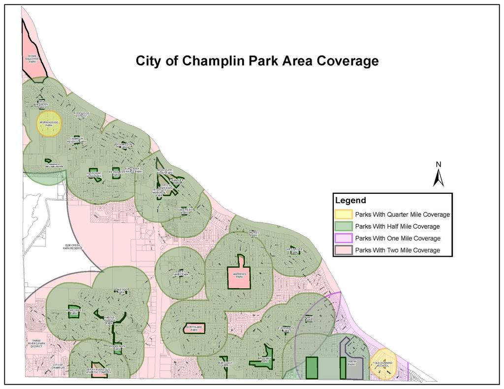
3 SECTION COMMUNITY CHARACTERISTICS Champlin is bordered by the Mississippi River and the City of Anoka to the north, the Elm Creek Park Reserve and the City of Dayton to the west, and the cities of Maple Grove and Brooklyn Park to the south. Champlin has 30 public parks comprising 295 acres and 25 miles of off-road trails throughout the community. The parks provide a wide range of recreational opportunities, while the trail system is a combination of off-road, on-road and internal park trails. An inventory of existing parks showing recreational facilities is attached as Table 4-1. The physical location of each park is shown in Figure 4-1. Champlin is in the Anoka-Hennepin School District and has two public schools; Champlin Brooklyn Park Academy and Jackson Middle School, which have several athletic fields and playgrounds. The School District and City provide their own separate maintenance schedules and capital improvement purchases for their fields and facilities. The School District rents ice time from the City at the Champlin Ice Forum. Occasionally, the City and School District assist the other in resource and facility maintenance sharing upon special requests and needs. Three Rivers Park District owns and manages a regional park, the 4,900 acre Elm Creek Park Reserve, 850 acres of which lies within Champlin s city limits. Elm Creek Park Reserve is designed to provide natural resource based recreation and education opportunities. Three Rivers Park District is the implementing agency for regional trails in and around Champlin. The trail system within the Elm Creek Park Reserve, as well as the Coon Rapids Dam Regional Park, provides miles of regional paved trail opportunities. may undergo a proposed name change by Three Rivers Park District in the near future. NATURAL RESOURCES The City has many natural resources including the Mississippi River, oak savanna, oak woodlands, wetlands, creeks, small ponds, various prairie areas and the newly renovated Mill Pond in The Elm Creek Park Reserve has many other natural resources that help support flora and fauna environments. The City is fortunate to have the Elm Creek 4-3
4 meandering through it. Significant investments have been made to preserve the Elm Creek with the goal to preserve a linear greenway along its shore. It is to be noted that the City has various land acquisitions that will need to take place in order to fulfill this vision plan and create a contiguous greenway trail corridor. HISTORIC AND CULTURAL RESOURCES Champlin has a rich history with a strong connection to the Mississippi River. The Champlin Historical Society actively promotes the history and helps manage the historic Dunning School, situated on park property, in partnership with the City of Champlin. GROWTH FORECASTS Champlin s 2016 population was 23,343. By the year 2040, the population of Champlin is predicted to be 24,000. Table 4-2 below outlines actual household figures through 2016 and forecasts through 2040: Table Population 16,849 22,193 23,089 23,343 23,200 24,200 24,000 Households 5,423 7,425 8,328 8,442 8,800 9,500 9,600 People per Household Employment 1,110 2,734 4,012 4,116 4,400 4,600 4,800 The City s park system is expected to support forecasted populations through Trails are added as development is completed in the northwest, commercial, and river areas in an attempt to connect neighborhoods to existing park and trail amenities. While there are no additional parks planned in the City, the future development of the last tracts of land will need to be studied to determine future park implications should proposed densities be changed. Land tracts will also need to be considered for purchase along the Elm Creek Greenway Corridor in order to make a final contiguous connection through this area, and private parcels owned along these corridors will need to be considered in these connections. Finally, property along the east and southeast side of the Mill Pond will need acquisition consideration in completing a parcel of land that would then connect Veterans Park to D.C. Chandler Park again as part of a contiguous land connection that falls in line with a master plan process for the Mississippi Commons. 4-4


5 GENERAL RECREATION TRENDS Recreation interests and participation are influenced by many factors. Age, population demographics, access to facilities, amount of leisure time, interest in the environment, new recreation technology, and social trends all influence recreation participation. In general, people are looking for quality recreation close to home, but are willing to travel to obtain better quality or more specialized activities. The following recreation trends have been observed in the Twin Cities area over the last ten years: Yoga and personal fitness at private gyms is increasing Trail use has boomed (walking, running, biking and in-line skating) Contact and non-contact recreation activities are growing depending on the sport (i.e. lacrosse and soccer) Most adult team sports participation is in decline as there are many recreational opportunities or not enough time in private lives to participate More youth are specializing in one sport and training year-round Disc golf has increased in popularity Participation in female sports activity has increased Off-leash dog parks are popular Pickle-ball is becoming a popular pastime Lawn bowling is becoming a common recreational activity and gaining popularity Adult volleyball is increasing in popularity RECREATION TRENDS IN CHAMPLIN Recreation participation in Champlin will continue to grow as the community grows. The following local trends are based upon recent participation and public comments: Splashpad recreation for small children is recognizable in Champlin s Andrews Park Increase in trail use and biking Extended seasons of play for baseball, softball and soccer Increased interest in flying drones Use of outdoor ice has diminished as youths have other opportunities Increased requests for park shelter rentals has grown tremendously and in some cases requests for public meeting room space exceed our capabilities 4-5

6 Increased interest in opportunities for Senior Citizens Our Learn to Skate programs continue to be popular Adult softball leagues are in decline but yard games are becoming more popular, as well as adult volleyball Pickle-ball is becoming an activity popular with older adults. PUBLIC OPINION SURVEY In 2017, the City of Champlin conducted a resident survey. In the survey, 89 percent of residents rate the maintenance and condition of City parks and trails as either excellent or good. In discussing a specific facility, 47 percent report members of their household use the Champlin Ice Forum; and 86% of households use the City s trail system. 79% of residents support water front park amenities such as docks, a swimming area, and outdoor performance area, and rental of water recreational equipment. 75% support the idea of creating a larger meeting/banquet room with kitchen facilities such as for weddings and community events. 61% of households utilize the Mississippi River as a community natural resource. 98% of residents surveyed believed that Park Maintenance was either an essential, very important, and or somewhat important service that the City needed to provide. IMPLICATIONS AND FUTURE TRENDS The following are likely trends based on Champlin demographics, user input and the public opinion survey: Trail use will continue to increase and demand for trail expansion and connections between parks and other City locations will grow Individual activities will continue to be as popular as team or group activities Interest in natural resources and open space will grow as the City develops Recreation facility development and operation partnerships with athletic groups will be more important to adequately maintain facilities Rental facilities and buildings to reserve for private functions need to be included in park reconstructions plans SIGNIFICANT FINDINGS Champlin s residential growth will occur in the northwest portion of the City Champlin will likely continue to have a moderate proportion of families with 4-6
7 children Partnerships with the business community, youth athletic associations and other service organizations will continue to be important for a comprehensive and efficient park system in Champlin Champlin will need to increase its financial investment both operationally and with capital investments to maintain a safe and well maintained park system Key open spaces and natural resources should be preserved in advance or in conjunction with development Evaluate the demand and the need for alternative recreational activities Residents are frequent users of Champlin parks and are generally satisfied with the park system; recreation participation will grow Overview of Park System Operations and Potential Developments Improvements to the park system are and will be made incrementally each year. Specific improvement projects are identified and prioritized within this plan and as a part of the City s Capital Improvement Plan (CIP). The CIP is an annual planning document that sets overall City priorities and funding. The City of Champlin has a park system with an approximate value of $11,000,000, (which does not include the value of the land). This was determined from the League of Minnesota Cities by appraisal of park facilities done from To properly maintain/replace equipment and facilities, a significant investment is made each year to help keep park infrastructure and equipment in safe and proper operating condition. As new facilities are added, this investment must proportionately increase. The City and athletic associations may consider working cooperatively and consider sharing financial responsibility to create indoor athletic facilities. This investment would allow organized youth athletics to continue to provide adequate programming to meet the growing needs of the community. The potential development of additional facilities would also assist the park system in being able to offer indoor recreational opportunities at times when athletic associations were not using said facilities. The City addresses playground equipment safety and accessibility concerns through a playground equipment replacement plan. This plan systematically lays out how the City will proceed with replacing equipment in the City to meet safety and accessibility concerns of existing playground equipment facilities. The City also addresses playground equipment safety by implementing a playground safety program that inventories and inspects equipment on a routine schedule for each park structure. This was implemented in 2015 and is in accord 4-7
8 with the National Playground Safety Institute s policies and procedures. The City has positive relationships with youth athletic organizations and service organizations such as the Champlin Dayton Athletic Association (CDAA), Champlin Park Baseball Association (CPBA), and Champlin Community Foundation (CCF). These partnerships, which include human resource and financial resource sharing, will continue to help make improvements to the park and recreation system at a greater pace than if the City progressed by itself. The City has built 25 miles of off-road trails in the community. This plan outlines the potential of up to 10 miles of off-road trails as land is purchased or trails are built. The City will need to continue to maintain existing trail infrastructure in order to offer a quality trail system. There is the potential of a linear park along the Mississippi Crossings land adjacent to the river, which would incorporate a trail system from the Trunk Highway 169 bridge to Mississippi Point Park. The purchasing of homes and the development along this area will dictate when this becomes viable. Possibly, the most important issue facing the Park System is the rejuvenation of two parks adjacent to the Mississippi River, Mississippi Point Park and D.C. Chandler Park. The reconstruction and programming for these parks are being addressed in master plans and include plans for Doris Kemp and Veterans Park as well as the Mill Pond area. Another important issue is developing a reliable funding program to maintain facilities. Funding of the system can be accomplished through additional allocations from the General Fund, partnerships with service organizations, and grants. The main concern is that park dedication fees, once used to supplement and fund the Park Reserve Capital Improvement Fund, are declining and are not reliable. Future maintenance funding will need to be drawn from either the general funds, or from referendum measures that support the upkeep of the assets in the park system. 4-8
9 SECTION PARK, TRAIL AND OPEN SPACE SYSTEM FRAMEWORK Parks, trails and open space are essential components of a healthy community. Champlin recognizes that provisions of adequate park, recreation, open space, and trail connections are essential to the health, safety, and welfare of the residents and persons working in the City. Decisions about parks, trails and open space affect the entire community, and if planned with care, can help increase quality of life and enhance sense of community. Therefore, it is important to have a set of guidelines to use in decision-making. The following framework was prepared to act as a guide for the preparation of the park plan and for on-going decision making. The framework criteria are based on national standards. Local needs and conditions are equally as important as these minimal standards. As such, this framework should be used as a guide and should be adjusted based on community needs, trends, etc. It is assumed that residents, land developers, city staff, commissions and officials will use this framework and knowledge of local conditions as they face decisions about parks, trails or open space. A typically accepted range (Per the National Recreation and Parks Association Guidelines), of overall park acreage per population is from a minimum of 10- acres/1,000 population to 20 or more acres per 1,000 population. These park acreage figures are for the core park system of mini-parks, neighborhood parks and playfields, and community parks and playfields. They do not include trail corridors, greenways, special use parks, school lands, regional parks or conservation areas. This overall figure should be viewed as a benchmark and should be adjusted based on local needs. 4.4 GENERAL PARK AND TRAIL CRITERIA The following park and trail criteria are applicable to all parks. In addition, the descriptions of each park classification contain specific criteria applicable to that park type. The location of parks and trails will be determined by the City using the park and trail plan. Parkland shall be suitable to its intended use. This means adequate size, parcel shape, soils, slope, access and relationship to adjacent land uses Parkland shall be continuous and undivided by roadways, railroad tracks, pipelines, or other impassible or unusable barriers Parkland shall be free from any contaminants or debris. Trail land shall be of sufficient width and slope to accommodate 8-10 wide 4-9
 and sidewalks within the park and adjoining rights of way.")
 Mini parks are small parks (0.")
10 trails and appropriate buffer areas. General guidelines include a minimum width of 20 30, a maximum slope of less than 5 percent, and in certain instances, an 8% grade is allowed by guidelines. When park land is dedicated, the developer is required to grade the park land and pave access and perimeter trails (not internal park trails) and sidewalks within the park and adjoining rights of way. All construction must meet City specifications 4.5 PARK AND TRAIL CLASSIFICATIONS Champlin s parks and trails are classified according to their use and function and are described below. MINI PARKS (Rosewood and Morningside) Mini parks are small parks (0.5 to 2 acres) which are designed to supplement neighborhood parks in specific settings where a neighborhood park is not available or a new neighborhood park cannot be provided. Mini parks typically contain children s play equipment and may also include a small open play area and/or picnic table or seating area. Mini parks typically do not include athletic fields or sports courts. In general mini parks are limited to the following situations: Additional park land and recreation facilities are needed and suitable land cannot be provided through a neighborhood or community park. Barriers such as major streets or railroads, etc. prevent convenient access to a neighborhood or community park. The presence of high-density residential development warrants additional parkland beyond the typical neighborhood facilities. NEIGHBORHOOD PARKS (Bartusch, Brittany, Elm Creek, Emery Farms, Evergreen, Harold Johnson, Heights, Josephine Nunn, Lakeside, Oak Creek, Paul Wethern, Pines, Reynolds, Richardson, Rosewood, Shores, West River Park, and Charest Woodlawn parks) Neighborhood parks are the core building block of the Champlin Park system. Neighborhood parks are designed to provide the day-to-day recreation 4-10

11 facilities for a 125 to 500 acre neighborhood (1/4 to 1/2 mile radius). These parks are designed to serve approximately 300 to 650 households. Neighborhood parks are typically between four and ten acres. The parks typically contain a children s play area, a picnic area, a basketball or pickle ball court, internal park trails, a small parking area and ball fields (softball, baseball, soccer, etc.). Ball fields are typically used for informal use, but they may also be used for youth athletic associations. Some neighborhood parks may contain a hockey rink, free skating area, tennis court or other similar recreation facility. Neighborhood parks may also include natural resources such as wetlands, wooded areas, etc. The following criteria should apply to new neighborhood parks in addition to existing neighborhood parks: Land shall be a contiguous area of 4 to 10 acres and shall have a length/width ratio of no more than 3/1. The parkland should have a minimum of 300 feet of frontage on a public street. At least 240 feet shall be contiguous frontage. The parkland shall have the general qualities needed to allow development of a quality neighborhood park. Land shall be centrally located within a neighborhood and easily accessed by pedestrian or bike. At least 75% of the total area of land shall have a slope of less than or equal to four percent (4%) and shall not be located within a storm water ponding area, drainage way or any other water body. At least 75% of the total land area shall be of solid sub grade, excluding areas composed primarily of peat or wetland soils. At least 75% of the total land area shall be of well-drained sub soils suitable to support the growth of healthy turf and athletic field use. The park area shall contain a minimum of four inches of topsoil depth and a minimum average depth of six inches and said topsoil shall be of a quality to support establishment of healthy turf and landscaping. NEIGHBORHOOD PLAYFIELDS Neighborhood playfields serve a dual function of providing recreation for neighborhoods and providing facilities for organized youth athletics. Neighborhood playfields have similar facilities as a neighborhood park, but they typically have multiple fields for youth athletic leagues. The playfields are typically larger than neighborhood parks and serve an area of between 500 and 2,000 acres (1.2 to 1 mile radius). In general, neighborhood playfields 4-11
12 shall meet the following criteria: Land shall be contiguous area of 7.5 to 15 acres and shall have a length/width ratio of no more than 3/1. The parkland should have a minimum of 600 feet of frontage on a public street. At least 400 feet shall be contiguous frontage. The parkland shall have the general qualities needed to allow development of a quality neighborhood playfield Land shall be centrally located within a neighborhood and easily accessed by vehicles, pedestrians or bicyclists. The land configuration, conditions and slope shall be conducive to recreation field development. At least 75% of the total area of land shall have a slope of less than or equal to four percent (4%) and shall not be located within a storm water ponding area, drainage way or any other water body. At least 75% of the total land area shall be of solid sub grade, excluding the area composed primarily of peat or wetland solids. At least 75% of the total land area shall be of well-drained sub soils suitable to support the growth of healthy turf and athletic field use. The park area shall contain a minimum of four inches of topsoil depth and a minimum average depth of six inches and said topsoil shall be of a quality to support establishment of healthy turf and landscaping. COMMUNITY PARKS AND COMMUNITY PLAYFIELD CRITERIA (Clyde Andrews, Donnie Galloway, D.C. Chandler, Jerry Ruppelius Athletic Complex, Mississippi Point, Northland, Reynolds, Doris Kemp, and Veterans Memorial Park) Community parks and playfields provide recreation facilities for community scale recreation. That can vary from multi-field athletic complexes to a natural resource based passive park area or combinations of both. Community parks serve a two plus square mile area. Users typically drive to these parks and playfields, although some community parks may also function as a neighborhood park for the adjacent area. Passive community parks are typically located around a natural resource such as a lake, wetland, significant woodland or other resource. Community playfields are based on recreation need and their locations should have good access and be compatible for active lighted ball fields. Community parks with active recreation uses (i.e. ball fields, sport courts, etc.) and playfields should meet the following criteria: 4-12
. The land to be dedicated or acquired shall be suitable to its intended use.")
13 Land shall be a continuous area of at least 20 acres for community parks and 40 acres for community athletic areas and shall typically have a length/width ratio of no more than 3/1 (but not in the case of Doris Kemp or Veterans Memorial Park). The land to be dedicated or acquired shall be suitable to its intended use. This means adequate size, parcel shape, public road frontage, soils, slope, access and relationship to adjacent land uses. Land shall be easily accessed by pedestrian or bike, and provide convenient and safe vehicle access to a collector or arterial street. For athletic complexes at least 90% of the total land area shall have a slope less than or equal to two percent and shall not contain a storm water ponding area, drainage way or any other water body. At least 90% of the total land area shall be of solid sub grade, excluding areas composed primarily of peat or wetland soils. In addition, the same percent of land area shall be covered with no less than six (6) inches of topsoil and shall be clear of over story vegetation. At least 90% of the total land area shall be of well-drained sub soils suitable to support the growth of healthy turf and athletic field use. Although Galloway Park is located in the flood plain, it is used to host athletic events, a disc golf course, and activities. Where possible, a larger area for a combined athletic and passive recreation park shall be dedicated/acquired. This larger site is intended to provide passive amenity-based recreation and an area for active athletic uses. Community parks which focus on passive recreation (trails, picnicking, water based recreation, etc.) should meet the following standards: Land shall be a continuous area of at least 20 acres with a minimum frontage on a public street of 400 feet. Land shall be easily accessed by pedestrian or bike, and also provide adequate car access by roadway. At least 10% of the total land area shall have a slope of less than or equal to 4% and shall not contain a water detention area, drainage way or any other water body. At least 10% of the total land area shall be of solid upland soils, excluding areas composed primarily of peat or wetland soils. Desirable characteristics include varied and rolling terrain, a mix of forest 4-13
14 and open grasslands and scenic features such as: lakeshore, river or stream frontage, and unique environmental, historical or cultural features. PARK / SCHOOL RECREATION AREA CRITERIA (Richardson Park used to qualify but is now adjacent to a private school, Lil Newtons, formerly Champlin/Dayton Elementary), Dunning Historic School House. During Champlin s original planning and development, the City and School District worked cooperatively on recreation facility planning and park use. While there are opportunities for shared facilities in the future, as of 2017, the school district and the City maintain their own respective facilities. Shared park/school area (suitable for school and community recreation use) will be jointly selected by the School District and City and shall have the following characteristics: Land shall be a continuous area of 15 to 40 acres and shall typically have a length/width ratio of no more than 4/1. Land shall be located directly adjacent to a school site and shall be easily and safely accessed by pedestrian, bike or automobile. At least 80% of the total land area shall have a slope of less than or equal to two percent and shall not contain a storm water ponding area, drainage way or any other body of water. At least 80% of the total land area shall be of solid upland soils, excluding areas composed primarily of peat or wetland soils. In addition, the same percent of land shall have a depth of topsoil of at least six inches and shall be clear of forest vegetation. At least 80% of the total land area shall be of well-drained sub soils suitable to support the growth of healthy turf and athletic field use. Land shall not include any areas of open water that could pose a safety hazard. SPECIAL USE PARKS (Dunning School, Doris Kemp, Veterans Memorial Park also double as these types of parks) Special use parks and recreation areas such as community golf courses, arenas, gardens, plaza, historic sites, skate parks, BMX bike areas, disc golf, off leash dog areas, etc. are based on the unique natural, cultural, historic or community feature of recreation activity. The size, configuration and location of these parks will be determined by the City on an individual basis. GREENWAY AREAS (Oxbow, Elm Creek Greenway Trail Corridor) Greenways are privately or publicly owned corridors of open space that often 4-14
15 follow natural land or water features and which are primarily managed to protect and enhance natural resources. Greenways are typically planned to establish a system of inter-linked natural resource features and corridors. Greenway widths will vary depending upon the charter of the land and the intent of the resource protection strategy. It is important to assure a wide enough corridor for the greenway to meet its intended function (i.e. a wildlife migration corridor may need to be wider than a stream corridor). LINEAR PARKS (Mississippi Crossings Area) Linear parks typically function as trail corridors. Land for linear parks should be provided within new subdivisions when the park plan shows a potential off-road trail corridor. Linear parks may also function as open space, wildlife corridors or a combination of uses depending upon their location and character. Linear parks used for trails should be wide enough as warranted to support a trail corridor and wider areas should provide sufficient upland to locate a trail and support facilities such as picnic areas, seating areas, open lawn areas, etc., at suitable locations. The character, alignment and width of the linear park will be dependent upon the function, resource area, terrain and the proposed subdivision. Trails located along waterways should be designed as such to accommodate potential changes in the waterway corridor. It is possible that Mississippi Point Park and D.C. Chandler fall under the definition of a linear park in the future depending upon the development that occurs along the Riverfront in their respective areas. This area may be contiguous with the area that is now part of the Mississippi Crossings that could someday become a linear park if the homes in these areas on the river bluff line are purchased with the intent of creating a linear park and trail system. TRAILS Trails are classified based on their function, design, and location (See Table 4-3). The most popular trails are for pedestrians and bicycles. There are separated trails (parallel sidewalks and bikeways) within the same corridor, combined trails (pedestrians and bikes on the same trail), bike lands (paved shoulder next to the street), unpaved natural trails and special use trails (cross country ski, horse, and snowmobile). Trail classifications, existing and proposed trail alignments and criteria are summarized in the Park and Trail Map (See Figure 4.2). The trail plan is designed to connect neighborhoods, parks, schools and commercial areas. The major trails can be used for recreation and transportation purposes. Trails within parks will be determined as part of the specific park design. The trail system within the City will also coincide and connect in various spots to both the Mississippi River Trail, a federal/state trail, and regional trails in the Elm Creek Park Reserve, and possibly the West Mississippi River Regional trail that is proposed by Hennepin County and Three Rivers Park District. 4-15
16 Table 4-3 Trail Classification System Trail Classifications Class I Separate pedestrian and bicycle trails. Class II combined pedestrian and bicycle trail Class III - Bikeway lane Nature trail Cross country ski trail Location and Use Off-street Surface Width Slope Bituminous or bituminous and concrete 5-6 feet for pedestrians 8-10 feet for bicycles 0-5% pedestrian 0-3% bike Off-street Bituminous 10 feet 0-3% average ON-street one way per side Within parks and conservation areas Within parks and conservation areas Striped lane next to vehicle lane Aggregate, wood chip or turf Snow 8-10 feet Slope to match road 4-6 feet 0-5% desirable 10% maximum varies0-15%+ for one or twodepending upon way difficulty Snowmobile Off-street Snow feet 0-10%+ trail Horse trail Off-street Turf or wood chips 10 feet 0-10%+ PARK AND TRAIL DEDICATION When new residential, commercial or industrial subdivisions are built, the City requires the dedication of park land or trails where shown on the Champlin Park and Trail Plan maps or as recommended by the Champlin City Council. Where general park service area locations are shown on the Park Plan map, the exact extent and location of the park land will be determined and recommended through detailed analysis and reviewed by City staff. Where no park or trail land is dedicated, the City will require cash in lieu thereof in any amount determined by the City Park Dedication Ordinance. Where a mix of cash and land dedication is required, the City will calculate the pro-rated cash dedication share based on the land dedication amount. 4-16
17 SECTION PLANNING AND PUBLIC INPUT PROCESS Over several months, the City gathered information from a wide variety of sources that have influence over or have a stake in Champlin s parks and recreation. The following sources were used to provide insight relevant to issues associated with growth and parks, open space, trails and recreation. Park and Recreation Commission - The Champlin Parks and Recreation Commission oversaw preparation of the plan. The Commission worked with City staff and the community and provided guidance and input. Their continued energy and commitment will be instrumental as they guide park and recreation, renovation and development in the future. City Staff - City staff visited each park and many trail corridors to map and document existing conditions and to plan for future improvements. City Park Management, Programming, Maintenance, Planning, Engineering and Community Development staff participated in plan preparation or review. Public Opinion Survey - In 2017, Decision Resources Inc., conducted a statistically relevant survey of Champlin residents. The survey included questions about recreation facility use, satisfaction and priorities for the future. Focus Group Meetings - Focus group sessions were held with user and stakeholder groups including the Champlin Dayton Athletic Association (CDAA), Champlin Park Youth Hockey Association (CPYHA), Champlin Dayton Rebels Soccer Club (CDSC), Champlin Senior Club, Champlin Historical Society and Community Education (Anoka Hennepin School District 11). City Online Survey In late 2017, the City initiated an online survey regarding the Comprehensive Plan. The survey included questions pertaining to parks and recreation. 4-17
18 SECTION NEEDS ASSESSMENT AND RECOMMENDATIONS ANALYSIS This section analyzes Champlin s existing park, trail and open space needs based upon the Park System Framework contained in Section 2. The community input, growth forecasts and recreation trends are used in conjunction with the framework standards to define existing and future park needs. Recommended trail locations are determined by analysis of destinations (parks, schools, neighborhoods, shopping, etc.), the planned roadway network, the physical terrain and barriers and opportunities. COMMUNITY INPUT SUMMARY The following is a summary of the public input received by staff, Park and Recreation commission meetings, governmental agencies (i.e. Hennepin Co.) and public opinion survey both currently and during earlier comprehensive plan revisions: Increase the maintenance and rehabilitation of the existing facilities. Continue to provide off-road trail connections. (Please see recommendations regarding areas to be developed below). Consider areas for alternative forms of recreation like skateboarding, pickle-ball and disc golf/mini disc golf. Continue to provide recreational opportunities for the community s senior citizens Continue to irrigate athletic areas to provide safe and healthy turf for recreational and competitive competition. Consider other facilities to host community events and larger gatherings. Continue to provide and improve a location for senior citizens in the community to gather and recreate on a daily basis. Continue to examine the need for more rental space for reservations and commercial use. Some youth sports are experiencing a longer playing season creating facility scheduling difficulties when facilities are multi-use. Mississippi Crossings Plan established an outline to connect Mississippi Point, Doris Kemp, DC Chandler, and Veteran s Memorial Parks into one continuous Park. The City should continue to evaluate the feasibility of this concept and proceed as reasonably responsible. This will require acquisition of Richard Brown s property or a portion thereof. Use of Galloway Park for organized activities should be considered only after improvements are made to the school district facilities and after determining if there remains a need to provide additional athletic facilities (especially indoor facilities). Galloway Park should be kept as natural open 4-18
19 space. Should the efforts by the City to construct additional soccer fields in the community become unsuccessful, Galloway Park could serve as a location for this organized activity. Galloway Park is an acceptable site for this activity because it has the least impact on the natural surrounds and aesthetics of the park. The City should consider the merits of a greenway along the Elm Creek Corridor as the northwest area develops. This is partially being accomplished beginning in This will involve purchasing property along this area as opportunities become available. The construction of a performance area should be considered to provide for small community gatherings such as the Park and Recreation Department offering music and events. The City should consider construction of an open sided picnic shelter at Brittany Park to provide residents in southeast Champlin access to this amenity. The usage of the northern part of this park should be assessed for further field usage. BASEBALL AND SOFTBALL FIELD NEEDS The Champlin Dayton Athletic Association (CDAA) and Champlin Park Baseball Association (CPBA) offer youth athletic baseball and softball programs in the community. Both associations mostly schedule events (games & practices) Monday Thursday, mid-april-july. On some occasions events have been scheduled on Sundays. This excludes weekend tournament play. Currently the fields available to CDAA and CPBA in Champlin (includes CPHS) totals 26 fields with a capacity of approximately 36+ events per evening depending upon daylight, age group/game time length, and game scheduling(namely start and end times). The exception would be lighted fields. The three-year average of Champlin residents participating in CDAA baseball and softball was 1,659 in 2008, and is currently approximately 799 for the years 2015, 2016, and While youth baseball and softball participation is slowly in decline, City fields and facilities should be able to accommodate participation with the expectation that the City of Dayton will eventually build more fields and facilities. The most cost-effective way for the CDAA to accommodate the anticipated growth, would be to expand the days of the week events schedule to include Friday, Saturday, and Sunday. With the possibility of multiple events being scheduled on Saturday and Sunday, there should be an adequate number of facilities to provide youth baseball and softball without the need to add additional facilities. 4-19
20 The challenge for the City will be to continue to aggressively maintain these facilities on a daily basis to provide safe facilities. The fact that some of these facilities may need to be used nearly every day, long term maintenance and capital improvement planning are critical to be able to properly maintain said facilities. User fees need to be expected to increase with the cost of living increases. Most of the potential growth to the CDAA Baseball and Softball program will come from the cities of Dayton and Brooklyn Park. As these communities develop, the CDAA will need to position itself to gain a proportionate amount of access to facilities in these communities to meet their growing facility needs. ADDITIONAL PARKS Park locations in the City are geographically positioned to efficiently serve the residents in the adjacent neighborhoods (Figure 4.3). The City has 30 parks (with one private park at the Reserve at Elm Creek). Based on a needs assessment and proposed land uses there are no plans to develop additional parks. However, as the final larger land tracts are proposed for development, an assessment will need to be provided to the Parks and Recreation Commission regarding the density and number of overall residents these tracts will house for density. The Parks and Recreation Commission will then need to make a recommendation to the City Council upon the data provided regarding the proposed developments. The location of these areas and the number of residences proposed will also assist in determining whether new park facilities and dedicated park land need to be set aside and incorporated in the development plans, but again no additional parks are expected at this time. The Reserve at Elm Creek installed, a private playground, pool and recreational area for their neighborhood. This is not included in the overall park quantity count but was built to service the 100+ homes in that development. The remaining tracts of land, particularly the tracts of land on the northwest and west side of the City, (when they develop), will need to have a trail assessment for connections to these areas and to the larger trail system. It is assumed that these tracts will produce single residence additions. Based on parks in each area, the final density will determine if there are additional park lands and trails required in these areas. SOCCER FIELD NEEDS The Champlin Dayton Athletic Association (CDAA) and The Force Soccer Club administer youth recreational soccer in the community. CDAA schedules events (games & practices) Monday Thursday during July and August. The Force 4-20
21 administers youth soccer April-June and in September and October in the fall. CDAA currently has 1,136 number of soccer players and The Force is projected to have roughly 500 soccer players in their first season as a combined organization in 2018 (previously Rebels Soccer Club and The Northwest Kickers Club). There is a need for additional soccer fields as this sport is continuing to expand and heavy usage requires the turf/fields to be rotated. This allows field substitution and schedule modifications for particular fields each season to perform proper turf renovation and allow highly used turf time to recover. FOOTBALL FIELD NEEDS The Champlin Dayton Athletic Association (CDAA) administers youth football in the community. The CDAA schedules events (games & practices) Monday Thursday during August October and occasionally on Saturday and Sunday. There are approximately 320 participants registered in CDAA football. The group utilizes both Andrews and Northland Parks (two fields total in the City park system) as well as school district fields for games. There is a need in the park system to add additional football practice green space. Richardson Park will have practice green space added in 2017, as well as Northland Park as part of other repurposing projects. Other parks such as Brittany Park will also be reviewed in the future for other field/green space. LACROSSE The Champlin Park Youth Lacrosse Association is practicing and hosting games at Galloway Park and U12 games at Andrews Park. Staff has assisted the association with field needs since 2014 and continues to communicate with the association and provide additional space as is available in the system. ICE FORUM The Champlin Park Youth Hockey Association (CPYHA) administers youth competitive and recreational hockey in the community. The CPYHA schedules events (games & practices) Monday Sunday from September March. Parks & Recreation Staff offer public skating and a Learn to Skate Program to residents who enjoy ice-skating. One of the main issues that the City faces at the Ice Forum, is regarding the R-22 refrigeration system for its ice plant. As of 2020, R-22 will no longer be manufactured per the Environmental Protection Agency. Because of the mandate 4-21
22 for the cessation of R-22 manufacturing, staff is planning for the reconstruction of the refrigeration system. The City is analyzing the possibility of converting the ice plant to an ammonia type refrigeration plant. The cost of this conversion is significant and money is being sought for this conversion at both the State and Federal levels to assist in meeting the expenditures necessary in completing this process. The conversion will require the Ice Forum be shut-down while improvements are made and this is thought to be a six month undertaking. As of 2018, a feasibility study has produced the baseline cost figures necessary to update the ice plant at roughly $1.5 million. A secondary analysis is also being performed by the Honeywell Corporation to determine if the Champlin Ice Forum is eligible for a drop-in type of refrigerant that would be compatible with the current system in the ice plant. Should this become an option, staff will also weigh the pros and cons associated with reconfiguring various parts of the ice plant to accept this proprietary refrigerant. TRAIL SYSTEM NEEDS The construction of the off-road trail system is extremely valuable. The City should continue to provide additional off-road trails. The development of an inter-connecting off-road trail system will help guide development of a safe and efficient trail and sidewalk system that can assist the City and developers in planning pedestrian travel routes to and from neighborhoods, commercial areas and parklands. In 2017, a trail paving index was created and trails were evaluated, graded, and planned for particular maintenance or reconstruction. This will assist City staff to continue to maintain these trails as necessary. Trail connections will need to be considered in the larger land tract areas that are to be developed. Once proposed for development, these land tracts and the densities for housing will need to be brought forth for review if different than the single family residences that are planned for at this time. There are various other smaller tracts of land that will need to be evaluated for more trails including the Greenway Corridor should these land tracts be either developed or purchased for park and recreational purposes. The West Mississippi Regional River Trail is also being planned as of 2016, and will be a Three Rivers Park District and a Hennepin County project that will ultimately need City Council final approval. The final master plan was completed in May of 2018 and is attached. (Please see Addendum 1). This project is proposed to run the course of West River Road and Dayton River Road. Other land tracts east of TH 169 along the eastern shoreline of the Mill Pond will be parcels that could potentially connect D.C. Chandler to Veterans Park. It is anticipated that if this land is acquired, that accompanying covenants restricting various types of construction may be included. However, it 4-22
23 is thought that trails would not be included in these restrictions, and that these trails would provide a great amenity to many people walking around this area for recreation. Our trail system will require much financial resourcing to keep the system at a level with ratings above satisfactory, and therefore will require a trail maintenance program to be approved on an annual basis. Mississippi Crossings and Commons Area Staff is objectively looking at areas in the Mississippi Crossings and Commons areas that will produce meaningful access points to the Mississippi River. Significant investments are being made in acquiring land and planning for the possible usages with the river as the focal resource. Much effort is being placed in reviewing options and weighing opportunities for maximizing this area. 4-23
24 SECTION GOALS AND POLICIES PLANNING Goals: To develop and adopt a Comprehensive Park and Recreation Plan based on the needs and demands of all segments of Champlin s population. To coordinate the efforts of local, state and federal governments and agencies to plan and develop the Park and Recreation System. Policies: 1. That the Park and Recreation Plan be a responsive and dynamic document. It will be based on a five to ten year planning period. 2. That the Park and Recreation Plan seek to be compatible with adjacent local community plans and metropolitan, state and federal plans and programs. 3. That the description and standards established in the park classification system be the basis for development of the park and recreation system. 4. That park and recreation services and facilities be provided where recreational opportunity is deficient or non-existent. This shall be done in conjunction with the resources of the volunteer- based organizations and the private sector, where appropriate. 5. That the utilization of City staff be maximized in the planning process, with outside assistance sought when special capabilities are needed. 6. That this plan is supportive of current facilities and usage policies that guide the Parks and Recreation Department operations. SYSTEM MANAGEMENT Goals: To develop and adopt a philosophy for development and management of the park and recreation system. Policies: 1. That uniform park and recreation maintenance standards shall be developed and applied consistently throughout the City. 2. The City crews shall be utilized in maintenance and development of the 4-24
25 park and recreation system and that contracted service will be used when it is financially responsible to do so. 3. That community volunteer organizations shall be encouraged to participate in park and recreation development whenever appropriate. 4. That the City direct city recreation programs and coordinate athletic activities in conjunction with local athletic associations. 5. That the City provide the Park and Recreation Commission with the background information, technical data and staff recommendations on significant park and recreation issues. 6. That the City review all pertinent information, analyze the alternatives and make recommendations to the City Council on park and recreation issues. 7. That the City inform the City s residents on any major issues or improvements, via Parks and Recreation Commission meetings. 8. That the City consider the increased maintenance, planning, and recreational requests, inquiries, and demands made by the City and its residents, and determine appropriate responses according to available resources and man power. PARKS Goals: To promote park development that will best encourage and/or control use. To provide a well-balanced park and recreation system. To strengthen the image of the Parks as an overall system, which provides community services and recreational facilities. Policies: 1. To offer a variety of activities in the park and recreation system including cultural, conservation, passive, active and organized recreation areas. 2. To acquire parkland and create a trail system (and develop existing parks) at a level commensurate with the needs of Champlin s population. 3. To establish and promote high quality design standards in the development of the park system. 4. Joint use of facilities shall be encouraged by incorporating school facilities with park and recreation programs whenever possible. 5. To encourage multi-use park and recreation facilities that will maximize accessibility and use by area residents. 6. To allow the conversion of park and public open lands to other uses only 4-25
26 when no feasible alternative exists. When such conversion is unavoidable, the taking agency shall pay for the replacement of land and facilities to serve the needs of the people in that area. 7. Specific development priorities be reclassified annually. 8. Consistent with economic realities, innovative park development shall be encouraged. 9. Ongoing information and education processes shall be conducted, making the residents aware and knowledgeable of park and recreation facilities and programs. 10. Parkland shall be acquired in accordance with the City Park and Recreation Plan. 11. Require park dedication from all developers pursuant to City Ordinance. 12. Wetlands and storm water ponding areas shall not be accepted as fulfillment of park dedication requirements. 13. Provide public access into City park areas by a variety of transportation means. 14. A consistent signing policy shall be developed for all park and recreation areas, buildings, etc., including directional and informational signs. TRAIL SYSTEM Goals: To promote safe, convenient and coordinated facilities for alternative means of transportation throughout the City of Champlin. To provide Champlin residents with sections of trail that focus on recreational value and harmony with the natural environment. Policies: 1. To coordinate the park and recreation system through the use of a citywide trail plan. 2. To plan bicycle and pedestrian access to parks, open space areas, schools and neighborhood shopping areas to encourage maximum use of these facilities. 3. To encourage the utilization of utility easements and transportation rightof-ways for trail development. 4. To provide ramped curbs to meet accessibility standards and to accommodate bicyclists. 5. That trails be bituminous or concrete, except in nature areas, and be multi-use facilities when uses are compatible. 6. That trails be integral to larger scale development and shall be installed 4-26
27 and paved at the developers expense. These trails shall connect to the existing and proposed extensions of the Champlin trail system. 7. That the Champlin trail system be coordinated with the trail systems for surrounding cities, Hennepin County, the Metropolitan Council and Three Rivers Park District. 8. That all existing and proposed trails shall be mapped, reviewed and updated annually. RECREATION Goals: To provide a safe, pleasant recreational system, which will offer a variety of facilities and programs for all age groups in the community for all seasons of the year. Policies: 1. To encourage the development of programs for all compatible outdoor and indoor recreational activities. 2. That recreation programs shall be accessible to all members of the community. 3. That regulations and policies regarding the use of Champlin park and recreation facilities shall be developed, then enforced, by the Park and Recreation Department. 4. Athletic activities shall be coordinated with the local athletic associations whenever appropriate. 5. That fees obtained for specific recreation programs and events shall be used to support those programs and events. 6. That some community-based recreation programs (i.e. Father Hennepin Festival) shall be designed to be self-supporting. 7. That fees obtained for the use of park and recreation facilities shall be directed to maintenance, development, acquisition or administration. 8. That fees obtained for youth recreational programs cover the cost of putting on the program. These costs include part time staff, supplies, admissions, etc. 9. That fees obtained for adult recreational programs will be used to support those programs and events. 4-27
28 CITIZEN INPUT Goals: To implement a planning process incorporating citizens at all levels. To promote citizen interest and involvement in City Park and Recreation programs. Policies: 1. To encourage citizens to serve on the Park and Recreation Commission and its subcommittees. 2. To provide park and recreation improvement programs designed for participation of both community groups and individuals of all ages. 3. To promote discussion with community organizations as part of the review and update process of the Park and Recreation Plan and reclassification of priorities. 4. That the community shall be encouraged to participate in the planning of major park improvements and that neighborhood meetings shall be held to gather input before implementation of the applicable improvement. 5. That a sampling of community attributes be completed periodically as to provide the park and recreation system with community input. 6. To encourage the use of social media to distribute information regarding recreation activities and park facilities through all available communication outlets. 7. To recognize the stewardship of various individuals and organizations who make contribution to the park and recreation system (i.e. Adopt-A-Park). FUNDING AND EXPENDITURES Goals: To fund replacement and upgrades to the park and recreation system utilizing an annual transfer from the general fund. To maximize the benefits received from the expenditure of funds allotted for park and recreation facilities and programs. To capitalize upon the many sources of grants and aid at the local, state and federal levels. To encourage financial participation from those groups who actively use the 4-28
29 park and recreation system. To work with the Champlin Community Foundation, CDAA, CPBA, and neighboring cities which allow residents, businesses and other foundations to make tax-deductible donations towards improvements in the Champlin Park and Recreation. Policies: 1. That a ten year Park and Recreation Capital Improvement Program (CIP) be adopted and annually updated with the City s CIP. 2. That the provisions of facilities for non-resident and profit motivated or special interest groups be made self- sustaining through user charges. 3. That user charges for resident groups be incurred to cover operation costs. 4. That all user charges collected be directed to park and recreation maintenance development and renovation. 5. That all cash obtained as park dedication fees shall be directed to the park reserve fund to be used for park and recreation projects. 6. That creative methods of funding for parks and recreation projects be encouraged. This includes obtaining funds or other assistance from private foundations, business, industry, residents and community organizations. 7. That serious effort will be made to program City funds for parks and recreation consistent with increasing maintenance and rehabilitation costs. 8. That a funding plan be developed to ensure the replacement of park and recreation facilities as they age and are in need of major maintenance or upgrade. 9. That enterprise operations be established for those park and recreation facilities that can be supported by revenues and if revenues are generated more than expenditures, that those revenues be used to improve the facility. 10. Park Bond Referendum as a way to introduce programs and facilities. 4-29
30 SECTION IMPLEMENTATION AND STRATEGY Goals: To implement the Park and Recreation Plan to ensure proper development of park and recreation facilities and programs. Policies: 1. To promote review of the Park and Recreation Plan (a chapter in the overall Comprehensive Guide Plan) by adjacent affected agencies and units of government. 2. That a public hearing shall be held on the Park and Recreation Plan, and that following the public hearing process, the City Council shall formally adopt said plan. 3. To employ modern legal and administrative tools (subdivision and zoning regulations, capital improvements programming, budgeting, etc.) to further the goals and support the policies of the Park and Recreation Plan. IMPLEMENTATION STRATEGIES 1. Review and prioritize trail needs and determine schedule and funding framework. In 2017, an asphalt and trail indexing system was created to evaluate trail conditions. In 2018, a sidewalk evaluation will be performed to address conditions of the sidewalk system that doubles as hard surface areas that connect various trail systems in the City. 2. Review and evaluate each planned development project to ensure it provides appropriate park dedication, open space preservation and trail connections to the planned City-wide trail and greenway system. 3. Increase the General Fund Transfer to the Park Reserve Fund to amounts that support level of service standards that cover staffing and maintenance needs. 4. Consider youth athletic association user fees as costs to maintenance and operations. Proportional increases as deemed necessary will occur as costs require. 5. Replace playground equipment every 20 years or as needed. 6. Utilize the capital improvement plan to forecast maintenance requirements to properly fund the necessary improvement projects associated with longevity, safety, and new park improvements. 7. Encourage financial contribution from athletic associations. 4-30
31 8. Assume Arena Fund will need $50,000 each year to help operate and maintain the facility over the next 10 years. Apply for Grants to convert current R-22 system to ammonia. 9. Park Bond Referendum could be considered in the future to help support, maintain and expand the park and recreational opportunities in the community, including the renovation to Mississippi Point Park and D.C. Chandler Park. 10. Adjust expenditures according to the actual funding received. PARK CAPITAL IMPROVEMENTS A ten-year Park and Recreation Capital Improvement Program is adopted and annually updated. This program includes prioritized costs associated with the park, recreation and trail system. The order of priority for development of the park and recreation system is directed to be consistent with the increasing community needs and priorities. These needs and priorities are assessed by evaluation of existing infrastructure by staff including opportunities for the public, evaluation of current recreational programs and facility conditions, and analysis of future City growth projections. The City looks for funding from a variety of sources. Park dedication fees (received in lieu of parkland dedication) and funds allocated from the general fund are the predominant funding sources. The City also actively pursues grants and aid from the local, state and federal government sources, and funds or other assistance from private foundations, business, industry, and community organizations. Special park and recreational opportunities may also be considered for bond issues. The Parks, Recreation and Trail Master Plan expands and completes the City s trail system. These proposed expansions include approx miles of trail linkages and expansions within the City if the proposed West Mississippi Regional River Trail is constructed by Hennepin County and Three Rivers Park District. Development of these additional miles of trails will be expected to occur as development progresses and or the county or state perceive the need for regional or state trail connections in or through Champlin. For example, the West Mississippi River Regional Trail Project that is being planned by Three Rivers Park District, Hennepin County and the Metropolitan Council. Exact locations of the trails will be determined through the site planning and PUD process, so as to meet the basic intent of the plan and the proposed project s specific needs. Trails within new developments may occur along roadways, within greenway corridors or as part of utility/trail easements. 4-31

32 Andrews Park Ward 3 Location Size Classification Adjacent Land Use th Ave N acres Community Park Residential Existing Proposed Improvement/Changes 2 Concession Stands 2 Enclosed Shelter 1 Warming House 2 Sand Volleyball Courts 3 Soccer Fields 2 Hockey Rinks 5 Ballfields 4 Tennis Courts 1 Football Field Nature Area Open Play Area Picnic Area Play Equipment Free Skating Rink Trails Splash Pad Volleyball Courts for Adult Athletics East Driveway Gate 4-32
33 Bartusch Park Ward 4 Location Size Classification Adjacent Land Use Quebec Ave N acres Neighborhood Park Residential Existing Proposed 1 Basketball Court 1 Sand Volleyball Court Nature Area Open Play Area Play Equipment Trails Basketball court resurfacing Notes & Comments Playground equipment scheduled for 2024/25 Consideration should be given to remove the sand volleyball court 4-33
 1 Basketball Court 1 Hockey Rink 2 Ballfields Nature Area Open Play Area Play Equipment Skating Rink Trails Add")
34 Brittany Park Ward 4 Location Size Classification Adjacent Land Use Brittany Drive acres Community Park Residential Existing Proposed 1 Warming House (Temporary) 1 Basketball Court 1 Hockey Rink 2 Ballfields Nature Area Open Play Area Play Equipment Skating Rink Trails Add Soccer Field to North Reconstruct Parking Lot Reposition Trail System Irrigate North Part of the Park Reposition or rebuild existing hockey rink Resurface basketball court Notes & Comments 4-34
35 DC Chandler Park Ward 3 Location Size Classification Adjacent Land Use 685 West River Road 4.06 acres Neighborhood Park Residential, Park Existing 2 Tennis Courts Nature Area Open Play Area Trails Proposed Reconstruct/Repurpose Entire Park Park is Under Planning Review by the City Council. Reconstruction to occur in Remove existing tennis courts Notes & Comments Play equipment was removed in 2002 Park has old restroom facilities that are currently not being used 4-35
 Open Play Area Trails Athletic Fields Disc Golf Course Possible Extension of Disc Golf from 9 to 18 holes.")
36 Galloway Park Ward 1 Location Size Classification Adjacent Land Use 1335 Dayton Road acres Community Park Residential Existing Proposed Nature Area (Prairie) Open Play Area Trails Athletic Fields Disc Golf Course Possible Extension of Disc Golf from 9 to 18 holes. Potentially irrigated fields Notes & Comments Park could have additional infrastructure added but will need an athletic association partner to help fund proposed improvements. 4-36

37 Doris Kemp Park Ward 1 Location 921 Hwy 169 Size Classification Adjacent Land Use acres Community Park Commercial, Park Existing Nature Area Picnic Area Fishing Pier Flower Garden Trails Proposed Possible Picnic Shelter Remove Existing Deck Platform Notes & Comments Additional investments in the flower beds in cooperation with the Champlin Garden Club 4-37

38 Dunning School Ward 4 Location Road Size Classification Adjacent Land Use West River 1.0 acres Historic Park Residential Existing Proposed Champlin Historical Society Historic Building 2017 exterior is being repaired from donation funding Notes & Comments Continued maintenance improvements are necessary to preserve the building for future generations as conditions warrant. 4-38
39 Elm Creek Terrace Park Ward 1 Location Size Classification Adjacent Land Use 50 Trussel Ave N 1.3 acres Neighborhood Park Residential Existing Proposed Open Play Area Play Equipment Notes & Comments Playground equipment upgrade scheduled for

40 Emery Village Park Ward 3 Location Size Classification Adjacent Land Use Emery Village Drive 2.08 acres Neighborhood Park Residential Existing Open Play Area Play Equipment Basketball Court Trails Proposed Paint Basketball Courts Notes & Comments Developed in 2006, scheduled for new equipment in

41 Evergreen Park Ward 4 Location Size Classification Adjacent Land Use Florida Ave N 4.47 acres Neighborhood Park Residential Existing Proposed 1 Basketball Court 1 Sand Volleyball Court Open Play Area Play Equipment Trails Possibly Mini Disc Golf Course Notes & Comments Playground equipment upgrade scheduled for 2029 Basketball court repainted and reconstructed in
42 Harold Johnson Park Ward 2 Location Size Classification Adjacent Land Use 9801 Elm Creek Parkway 5.69 acres Neighborhood Park Residential Existing Proposed 1 Basketball Court Open Play Area Play Equipment Trails Notes & Comments Playground equipment upgrade scheduled in 2033 Trails updated in 2016 and
43 Heights Park Ward 1 Location Size Classification Adjacent Land Use 710 Parkview Lane 3.29 acres Neighborhood Park Residential Existing Proposed 1 Basketball Court Open Play Area Play Equipment Trails Notes & Comments Basketball Court repainted in

44 Highpointe Park Ward 2 Location Parkway Size Classification Adjacent Land Use Goose Lake 9.72 acres Neighborhood Park Residential Existing Proposed 2 Tennis Courts 1 Ballfield Open Play Area Play Equipment Trails Sliding Hills Notes & Comments Playground equipment replacement scheduled in 2030 Drainage swale cut down and trees planted in 2017 Trails re-built in

45 Jerry Ruppelius Athletic Complex Ward 2 Location Parkway Size Classification Adjacent Land Use Elm Creek acres Community Park Residential Existing 1 Soccer Field 2 Ballfields Open Play Area Picnic Shelter Youth Athletic Storage Facility Play Equipment Batting Cages Proposed Notes & Comments Basketball court repainted in
46 Josephine Nunn Park Ward 1 Location Size Classification Adjacent Land Use Monticello Lane N acres Neighborhood Park Residential Existing Proposed Nature Area Open Play Area Play Equipment Trails Notes & Comments Playground equipment replaced in 2028 Pave Trails as part of potential Elm Creek Greenway Corridor 4-46
47 Lakeside Park Ward 2 Location Size Classification Adjacent Land Use 9410 Lakeside Trail 2.8 acres Neighborhood Park Residential, Elm Creek Park Reserve Existing Proposed 1 Basketball Court Nature Area Open Play Area Play Equipment Trails Notes & Comments Playground equipment scheduled for replacement in Equipment was replaced in 2012 Basketball court was repainted in

48 Mississippi Point Park Ward 1 Location Size Classification Adjacent Land Use 651 West River Road 7 acres Community Park Residential Existing Nature Area Boat Launch Shore Fishing Picnic Area Trails Proposed Performance Center Picnic Shelter Bridge to D.C. Chandler in Lower Park Boat Docks Notes & Comments Under planning and proposal with City Council in 2017/
49 Morningside Park Ward 1 Location Size Classification Adjacent Land Use Union Terrace Lane 0.5 acres Neighborhood Park Residential Existing Proposed Play Equipment Notes & Comments Consideration should be given to repurposing this park property. 4-49

50 Northland Park Ward 2 Location North Size Classification Adjacent Land Use th Avenue acres Community Park Residential Existing Proposed 1 Warming House 1 Basketball Court 1 Football Field 2 Hockey Rinks 3 Ballfields Open Play Area Play Equipment Skating Rink Trails Sand Volleyball Court Picnic Shelter Pave Trails in Ball Field Area Notes & Comments Exterior of warming house needs upgrade in the next 5 years Interior was reconstructed in 2017 New boards and rink in 2018 Paint basketball court in
51 Oak Creek Park Ward 3 Location Size Classification Adjacent Land Use 1306 Pleasant View Lane 2.51 acres Neighborhood Park Residential, Church Existing Proposed 1 Basketball Court 1 Ballfield Open Play Area Play Equipment Trails 1 Pickle ball Court Notes & Comments Servant of Christ Church allows users to park in their parking lot to access the facilities. New trails and basketball court painted in
52 Oxbow Park Ward 4 Location Size Classification Adjacent Land Use th Avenue North 39.9 acres Community Park Residential, School Existing Proposed Nature Area Trails Notes & Comments Trails graded in

53 Wethern Park Ward 1 Location Lane Size Classification Valley Forge 3.55 acres Neighborhood Park Adjacent Land Use Residential Existing Proposed 1 Basketball Court 1 Ballfield Play Equipment Trails 2 Pickle Ball Courts Notes and Comments Pickle Ball was added in 2016 and trails to the west 4-53

54 Pines Park Ward 4 Location North Size Classification Adjacent Land Use th Avenue 2.71 acres Neighborhood Park Residential Existing Proposed 1 Basketball Court 1 Hockey Rink 1 Ballfield Play Equipment Trails U9/U10 Soccer Field Paved parking area Notes & Comments Playground equipment scheduled for replacement in 2031 Basketball court to be painted in

55 Reynolds Park Ward 1 Location Size Classification Adjacent Land Use 821 Cartway Road 5.33 acres Neighborhood Park Residential Existing 1 Ballfield Open Play Area Proposed Trail Head from Southwest Parking Lot Notes & Comments Ball field was renovated in 2014/15 Cartway Trail connection in

56 Richardson Park Ward 1 Location Size Classification Adjacent Land Use Commercial 302 Colburn Street 2.83 acres Neighborhood Park Residential, Existing Proposed 1 Warming House 1 Hockey Rink 1 Soccer/Football field 2 Tennis Courts Skating Rink Remove Existing Warming House and Add Temporary Warming House Re-position Hockey Rink to Allow U9/10 Soccer Field, and Football Practice Green Space Re-light and LED the Park and Tennis Courts Ball Field to be Eliminated Notes & Comments Park to be reconstructed in
57 Rosewood Park Ward 1 Location Parkway Size Classification Adjacent Land Use 618 West River 0.23 acres Neighborhood Park Residential Existing Proposed Play Equipment Notes & Comments Playground equipment scheduled for replacement in

58 Shores Park Ward 3 Location Size Classification 7003 River Shore Lane 1.41 acres Neighborhood Park Adjacent Land Use Residential Existing Proposed 1 Basketball Court Open Play Area Play Equipment Trails Notes & Comments Play equipment scheduled for 2025 Basketball court resurfaced in

59 Veteran s Memorial Park Ward 1 Location Lake Road Size Classification Adjacent Land Use Commercial, Park 505 East Hayden 1.74 acres Community Park Residential, Existing Picnic Area Veteran s Memorial Picnic Shelter Trails Proposed Notes & Comments Constructed additional Veterans Memorial in 2016 Consider larger picnic shelter for weddings in the future Tree for Christmas lighting in

60 West River Park Ward 3 Location Drive Size Classification Adjacent Land Use Mississippi 3.3 acres Neighborhood Park Residential Existing Proposed 1 Basketball Court 1 Ballfield Open Play Area Play Equipment Trails Paved parking area Notes & Comments Basketball court repainted in

61 Woodlawn Park Ward 2 Location Independence Avenue Size Classification Adjacent Land Use 6.2 acres Neighborhood Park Residential Existing Proposed 1 Basketball Court 1 Hockey Rink 1 Ballfield Open Play Area Play Equipment Trails Warming House Paved parking lot Notes & Comments Basketball court repainted in

62 Champlin Parks
63 63

64 Figure
PARK, RECREATION AND TRAIL PLAN
 4.1 EXECUTIVE SUMMARY The Comprehensive Park, Recreation, and Trail Master Plan establishes the vision for the park system including maintenance, renovation and enhancement. The plan concludes that the
RECREATION AND OPEN SPACE ELEMENT GOALS, OBJECTIVES, AND POLICIES
 RECREATION AND OPEN SPACE ELEMENT GOALS, OBJECTIVES, AND POLICIES Goal 7 To provide park facilities, recreation programs, and open space resources that are safe, adequate, and accessible to all City residents,
Courthouse Planning Area
 Courthouse Planning Area Current Reality The Courthouse Planning Area is the characterized by expansive suburbanscale residential areas as well as the community resource planned area of athletic, educational,
RECREATION AND OPEN SPACE ELEMENT
 RECREATION AND OPEN SPACE ELEMENT Last amended August 19, 2008 Table of Contents Objective Page 5.1 Park system defined... 5-1 5.2 Access to parks and recreational facilities... 5-2 5.3 Recreation and
1. Parks & Recreation Neighborhood Parks Community Parks Special Use Sites 2. Open Space 3. Trails
 Appendix A: Park Classifications The intent of parks and recreation classifications is to aid in making acquisition and design decisions for park sites, facilities and the organization of recreation space
Mendota Heights 2040 Comprehensive Plan Draft Vers
 4 Parks and Trails The City of Mendota Heights boasts a variety of recreational and open space opportunities. Few cities can claim access to regional trails, riverside and lakeside parks, scenic bluffs
Appendix A. Park Land Definitions
 Appendix A Park Land Definitions Mini Park May serve specific function for any and all ages, depending on need of the user area. Size range 1-5 acres with optimum size being 3 acres. Service area is sub-neighborhood
Little Neck Planning Area
 Little Neck Planning Area Current Reality The Little Neck Planning Area is characterized by established residential neighborhoods, Town Center and Pembroke. The Eastern and Western Branches of the Lynnhaven
3. VISION AND GOALS. Vision Statement. Goals, Objectives and Policies
 Vision Statement Queen Creek s interconnected network of parks, trails, open spaces and recreation opportunities provide safe and diverse activities and programs that sustain its unique, small town, equestrian
Provide and maintain sufficient public parks, recreation facilities, and open space to meet the recreational needs of County residents and visitors.
 (ROS) Goal Provide and maintain sufficient public parks, recreation facilities, and open space to meet the recreational needs of County residents and visitors. OBJECTIVE ROS.01 The County shall acquire,
APPENDIX D2: PARKS AND TRAILS
 APPENDIX D2: PARKS AND TRAILS Cultivate Hopkins Comprehensive Plan 8/15/18 DRAFT Cultivate Hopkins Appendix D2 1 Existing Conditions Local Parks and Trails Figure D2.1 shows the existing park and trail
STAFF RECOMMENDATION: Adopt the Parks and Recreation Master Plan 2013, or take other action as deemed appropriate.
 Regular 7. CITY COUNCIL AGENDA Meeting Date: 12/02/2013 TITLE: Parks and Recreation Master Plan 2013 Adoption Proposal - Dwight Curtis Responsible Staff: Dwight Curtis Backup Material: Backup material
Parks, and Recreation & Cultural Arts Master Plan Update
 Parks, and Recreation & Cultural Arts Master Plan Update Community Profile Public Input Summary: Staff Interviews conducted April 14 and 15, 2014 Citizens Workshop - conducted April 15 th and 24 th, May
City Council March 27, Parks, Recreation, and Trails Master Plan
 City Council March 27, 2018 Parks, Recreation, and Trails Master Plan Planning Process Develop Goals and Objectives Inventory of Areas and Facilities Needs Assessment And Identification Public Participation
Great Neck Planning Area
 Great Neck Planning Area Current Reality The Great Neck Planning area is characterized primarily by large lot/lowdensity residential development with the majority of recreational opportunity existing as
G. RECREATION AND OPEN SPACE ELEMENT. The following summarizes the Recreation and Open Space Element:
 G. RECREATION AND OPEN SPACE ELEMENT The purpose of the Element is to provide the framework and direction for a comprehensive system of public and private sites for recreation, including, but not limited
PARKS AND RECREATION
 PARKS AND RECREATION WHAT YOU WILL FIND IN THIS CHAPTER: Background information on the development of the Park, Recreation, and System Plan (PRSP). General overview of Ellensburg s parks and recreation
Chapter Purpose and Intent. 7.2 Applicability. 7.3 General Provisions RECREATIONAL OPEN SPACE
 Chapter 7. RECREATIONAL OPEN SPACE 7.1 Purpose and Intent The intent of this Chapter is to provide for centrally located, unencumbered land as neighborhood recreational open space and not to permit the
Comprehensive Plan ADOPTED APRIL 2014
 Comprehensive Plan ADOPTED APRIL 2014 8 8. Outstanding Recreational & Cultural Opportunities We are proud of our community s parks and recreation system. Our community will ensure that the legacy of our
Draft Stillwater 2030 Comprehensive Plan- Goals and Policies
 Draft Stillwater 2030 Comprehensive Plan- Goals and Policies Instructions- Review each goal and policy and discuss with group any changes, deletions for additions to the list using your groups pen. Keep
Parks, Trails, and Open space Element
 Parks, Trails, and Open space Element Parks, Trails, and Open Space element Parks, Recreation, and Open Space are important components of the quality of life desired by the residents of Elk Grove. This
Southeast Quadrant Plan
 Southeast Quadrant Plan Southeast Quadrant Distinctive Features Land Use The Southeast Quadrant includes all the area within the planning area that is east of Interstate 5 and south of State Route 44.
Northeast Quadrant Plan
 Northeast Quadrant Plan Northeast Quadrant Distinctive Features Land Use The Northeast Quadrant includes all the area within the planning area that is east of Interstate 5 and to the north of State Route
Kempsville Planning Area
 Kempsville Planning Area Current Reality The Kempsville Planning Area is by far the most populated planning area in the City. The preservation of the 1,422 Stumpy Lake Natural Area, the largest City-owned
Pungo/Blackwater Planning Area
 Pungo/Blackwater Planning Area Current Reality The Pungo/Blackwater Planning Area represents the rural landscape and lifestyle that encompasses nearly 40% of Virginia Beach. The Agricultural Reserve Program
OPEN SPACE CHAPTER 7: OVERVIEW. Preserve open space to protect natural resources, enhance character and provide passive recreation opportunities
 CHAPTER 7: OPEN SPACE OVERVIEW Ridgefield has made tremendous progress permanently preserving areas of town as open space. Open space preservation can serve many important purposes, including: protect
Comprehensive Park System Master Plan
 PARKS AND RECREATION Comprehensive Park System Master Plan Citizen Advisory Committee, June 5, 2012 - Meeting Notes Transcription MIG met with the Parks Citizen Advisory Committee on Tuesday, June 5th,
Exhibit A. 8:9 Scuffletown Rural Conservation District
 Exhibit A 8:9 Scuffletown Rural Conservation District 8:9.1 Intent and Purpose The Scuffletown Rural Conservation (SRC) District is intended to provide for residential development that supports the development
Support the implementation of Cape Coral's Comprehensive Plan. Protect and utilize the unique natural resources in the City.
 7.0 OVERVIEW - RECOMMENDATIONS Chapter 7 The preparation of the Cape Coral Parks and Recreation Master Plan spanned a period of approximately 12 months. Plan preparation included the input of a wide range
PARTF Scoring System for Grants
 PARTF Scoring System for Grants The members of the N.C. Parks and Recreation Authority use the PARTF scoring system as one of several tools to select grant recipients. Please provide all of the information
North Oakville East Parks Facilities Distribution Plan. November, 2009
 North Oakville East November, 2009 POLICY CONTEXT 1) Purpose a) The purpose of this document is to be a guide for the location, configuration, design and development of the parks system for the North Oakville
3.2 P - Park District
 3.2 P - Intent - The P: s are established to promote and maintain the development of recreational opportunities within the. The development of new parks or the major expansion of existing parks within
City of Mahtomedi Park System Plan Public Hearing Draft: September 13, 2006
 Chapter 6: IMPLEMENTATION INTRODUCTION Earlier chapters of this Plan analyzed existing conditions, identified park and recreation needs, and proposed park, trail, and open space recommendations. This chapter
Executive Summary. Parks and Recreation Plan. Executive Summary
 Parks and Recreation Plan Executive Summary The Whitemarsh Township Parks and Recreation Plan sets forth a vision for how Whitemarsh Township can provide a premiere parks and recreation system reflective
I-494 Rehabilitation Project SP (I-394 to Fish Lake Interchange) June 2014 Section 4(f) De Minimis Determination
 June 2014 Section 4(f) De Minimis Determination") I-494 Rehabilitation Project SP 2785-330 (I-394 to Fish Lake Interchange) June 2014 Section 4(f) De Minimis Determination State Project Number 2785-330 Federal Project No. NHPP-I494 (002) Trunk Highway:
I-494 Rehabilitation Project SP 2785-330 (I-394 to Fish Lake Interchange) June 2014 Section 4(f) De Minimis Determination State Project Number 2785-330 Federal Project No. NHPP-I494 (002) Trunk Highway:
The transportation system in a community is an
 7 TRANSPORTATION The transportation system in a community is an important factor contributing to the quality of life of the residents. Without a sound transportation system to bring both goods and patrons
CHAPPLES PARK MASTER PLAN
 CHAPPLES PARK MASTER PLAN Presentation of Preliminary Development Options Public Open House #2 Wednesday November 2 nd, 2016 TONIGHT S AGENDA 1. Welcome & Introductions 2. Presentation by Sierra Planning
This page intentionally blank.
 This page intentionally blank. Parks, Recreation, and Open Space Chapter Relationship to Vision Vision Parks, Recreation and Open Space Chapter Concepts County Government. County government that is accountable
The only significant recreation deficiency in Conway is the absence of an integrated greenway and multipurpose trail system.
 CHAPTER 6 RECREATION 1. Introduction This recreation chapter is prepared in compliance with recently revised state statutes dealing with the completion of municipal master plans [RSA 674:2 III (F)]. This
Yadkin River Greenway Feasibility Study Fact Sheet Village of Clemmons, Town of Lewisville, Town of Bermuda Run
 Fact Sheet Village of Clemmons, Town of Lewisville, Town of Bermuda Run Project Background The Yadkin River Greenway Feasibility Study is a joint project with the Village of Clemmons, the Town of Bermuda
Appendix E Section 4(f) Evaluation
 Evaluation") Appendix E Section 4(f) Evaluation Appendix E Draft Section 4(f) Evaluation E.1 Introduction This appendix addresses a federal regulation known as Section 4(f), which protects parks, recreation areas,
Appendix E Section 4(f) Evaluation Appendix E Draft Section 4(f) Evaluation E.1 Introduction This appendix addresses a federal regulation known as Section 4(f), which protects parks, recreation areas,
Chapter 6. Overall Vision RECOMMENDATIONS. More Trail and Trail. Connections. Equal Access to Park. Facilities and Programs. Water Access.
 Overall Vision More Trail and Trail Connections Equal Access to Park Facilities and Programs Water Access Environment Variety Chapter 6 RECOMMENDATIONS Chapter 6 The following recommendations for park,
Arlington, Virginia is a worldclass
 EXECUTIVE S U M M A RY Arlington maintains a rich variety of stable neighborhoods, quality schools and enlightened land use policies, and received the Environmental Protection Agency s highest award for
6. RECREATION AND OPEN SPACE ELEMENT
 6. RECREATION AND OPEN SPACE Introduction This Recreation and Open Space Element includes Goals, Objectives and Policies (GOP) that apply to the main campus in Gainesville and the Lake Wauburg Recreation
SECTION II SECTION II STATEMENT OF GOALS, OBJECTIVES, PRINCIPLES, ASSUMPTIONS, POLICIES AND STANDARDS
 STATEMENT OF GOALS, OBJECTIVES, PRINCIPLES, ASSUMPTIONS, POLICIES AND STANDARDS 1 2 STATEMENT OF GOALS, OBJECTIVES, PRINCIPLES, ASSUMPTIONS, POLICIES AND STANDARDS INTRODUCTION The New Jersey Municipal
M-NCPPC Park System in
 Park Planning & Stewardship Division Park & Trail Planning Section East County Science Center Master Plan Parks, Recreation, Trails, and Open Space- Issues and Opportunities PARK PLANNING & STEWARDSHIP
Parks, Trails, and Open Space Element
 P arks, Recreation, and Open Space are important components of the quality of life desired by the residents of Elk Grove. This Element of the General Plan addresses the City s goals, policies, and actions
Chapter 5: Recreation
 Chapter 5: Recreation Introduction and Setting Recreational opportunities within Nevada County are varied, ranging from public parks with intensively used active recreational facilities, to vast tracts
RECREATION AND OPEN SPACE VISION
 City of South Lake Tahoe General Plan Policy Document Recreation and Open Space Element INTRODUCTION This element provides the policy context for the City of South Lake Tahoe to achieve its vision for
Chapter 5: Natural Resources and Environment
 NATURAL RESOURCES AND ENVIRONMENT 5-1 5 Chapter 5: Natural Resources and Environment BACKGROUND AND INTENT Urban expansion represents the greatest risk for the future degradation of existing natural areas,
APPENDIX D: PARKS AND RECREATION ACTION PLAN
 APPENDIX D: PARKS AND RECREATION ACTION PLAN Goals The following goals are specific to the development, maintenance, and operation of the existing parks in the Township, as well as the acquisition and
PARKS & RECREATION SUBCOMMITTEE. Oct. 1, 2015
 PARKS & RECREATION SUBCOMMITTEE Oct. 1, 2015 1999 Bond - $22,000,000 Land Acquisition Allen Station Phase II Neighborhood Parks PREVIOUS BOND ELECTIONS 1999 & 2007 2002 Bond - $4,000,000 Allen Senior Recreation
The following principles guide the development of goals and strategies to protect and promote these amenities:
 OPEN SPACE/PARKS/TRAILS/RECREATION GOALS/STRATEGIES Cherry Hills Village is a living environment that offers low density development, open areas, public scenic vistas, public trails and public parks. This
Section 3 INVENTORY OF RECREATION LAND AND FACILITIES
 Photo of Juan Bautista de Anza Park Section 3 INVENTORY OF RECREATION LAND AND FACILITIES Summary of Findings Park Definitions Summary of Recreation Facilities Other Recreation Facilities Nearby Recreation
GENERAL LAND USE PLAN ELEMENT
 CITY OF Prepared by City of Medford Planning Department 200 South Ivy Street Medford, Oregon 97501 plnmed@ci.medford.or.us James E. Huber, AICP, Planning Director COMPREHENSIVE PLANNING SECTION John Adam,
RECREATION, OPEN SPACE AND GREENWAYS ELEMENT GOALS, OBJECTIVES, AND POLICIES
 RECREATION, OPEN SPACE AND GREENWAYS ELEMENT GOALS, OBJECTIVES, AND POLICIES GOAL R-1: DEVELOP A RECREATION, OPEN SPACE AND GREENWAYS SYSTEM AS AN INTEGRAL COMPONENT OF AN OVERALL, COUNTY-WIDE ECONOMIC
CARMODY PARK MASTER PLAN
 the site Smith Reservoir Cottonwood Lake Kendrick Lake Carmody Rec Center Carmody Middle School Pool Court Play Carmody Pond Sanderson Ditch Sports Fields Foothills Ice Arena Open Field why a master plan?
PARKS. Chapter Introduction
 Chapter 4. PARKS 4.1. Introduction This Parks Element of the 2016 Comprehensive Plan Update provides direction and guidance, based on citizen input, in order to improve and maintain the City s existing
Chapter 10 IMPLEMENTATION RECOMMENDATIONS
 Chapter 10 IMPLEMENTATION RECOMMENDATIONS The recommended land use plan presented in the previous chapter provides a design for the attainment of the urban and rural development and open space preservation
TABLE OF CONTENTS. Tables Table UC Davis Park and Open Space Resources
 TABLE OF CONTENTS 4.13 Recreation... 4.13-1 4.13.1 Environmental Setting... 4.13-1 4.13.2 Impacts and Mitigation Measures... 4.13-4 4.13.3 References... 4.13-8 Tables Table 4.13-1 UC Davis Park and Open
7.0 OPEN SPACE 7.1 OPEN SPACE DEDICATION CHAPTER 7: OPEN SPACE
 7.0 OPEN SPACE The intent of these requirements is to allow for the usage of centrally located unencumbered land as neighborhood open spaces and not to permit the use of leftover or otherwise unusable
Appendix 4 Park, Trail, and Recreation Facilities For more information, call the Park Planning and Stewardship Division at
 Appendix 4 Park, Trail, and Recreation Facilities For more information, call the Park Planning and Stewardship Division at 301-650-4380 montgomery county planning board maryland-national capital park and
EL DORADO COUNTY GENERAL PLAN PARKS AND RECREATION ELEMENT PRINCIPLE INTRODUCTION STATE AUTHORIZATION
 EL DORADO COUNTY GENERAL PLAN PARKS AND RECREATION ELEMENT PRINCIPLE The General Plan must identify the types of governmental services, including parks and recreation facilities, which are necessary to
PARK & RECREATION. Project Summaries
 PARK & RECREATION Project Summaries 45 BEAVER ISLAND TRAIL EXTENSION - PHASE VIII - 60TH ST S TO CITY LIMITS Project Number: PK.19.01 Construction Year: 2019 quality services to area residents who utilize
Special Revenue Funds
 Special Revenue Funds Special Revenue Funds account for the proceeds of specific revenue sources (other than special assessments for major capital projects) that are legally restricted to expenditures
Silverdale Regional Center
 Silverdale Regional Center Vision for Silverdale Regional Center The Silverdale Regional Center Plan (Plan) will guide the evolution of the Silverdale Regional Center from a collection of strip malls and
PARK AND RECREATION MASTER PLAN UPDATE
 PARK AND RECREATION MASTER PLAN UPDATE 2014-2018 Prepared for: Avon Parks, Recreation and Beautification Council (PRBC) and Town of Avon Prepared by: Lehman & Lehman, Inc. 24-Apr-14 Mission Statement The
OPEN SPACE, PARKS, AND HISTORIC SITES
 OPEN SPACE, PARKS, AND HISTORIC SITES The conservation of land, water, and historic resources, and the related provision of recreation opportunities, is one of the most important factors in maintaining
RECREATION AND OPEN SPACE ELEMENT GOALS, OBJECTIVES, AND POLICIES
 RECREATION AND OPEN SPACE ELEMENT GOALS, OBJECTIVES, AND POLICIES GOALS, OBJECTIVES AND POLICIES GOAL 1: TO PROVIDE A FULL RANGE OF RECREATIONAL ACTIVITIES THAT ARE ACCESSIBLE, COMPATIBLE AND CONTINUOUS
Gold Line Bus Rapid Transit Transit Oriented Development (BRTOD) Helmo Station Area Plan
 Helmo Station Area Plan") Appendix F Gold Line Bus Rapid Transit Transit Oriented Development (BRTOD) Helmo Station Area Plan Introduction and Purpose of the Plan The Gold Line Bus Rapid Transit facility is an eleven-mile dedicated
Appendix F Gold Line Bus Rapid Transit Transit Oriented Development (BRTOD) Helmo Station Area Plan Introduction and Purpose of the Plan The Gold Line Bus Rapid Transit facility is an eleven-mile dedicated
City of Missoula and Missoula County Open Space Planning Open House
 City of Missoula and Missoula County Open Space Planning Open House FEBRUARY 6, 2018 The following slides contain the display board content from the open house. Please use boards to answer questions in
CHAPPLES PARK MASTER PLAN. Presentation to Council April 10, 2017
 CHAPPLES PARK MASTER PLAN Presentation to Council April 10, 2017 1 PRESENTATION AGENDA 1. Project Background, Aim and Process 2. The Site Issues and Opportunities 3. Community Engagement 4. Vision and
SECTION 4 OPEN SPACE ELEMENT
 Open Space Element SECTION 4 OPEN SPACE ELEMENT c 4.1 INTRODUCTION 4.1.1 SCOPE OF ELEMENT The state requires every general plan to have an open space element Section 65302{e». The open space element must
Focus Groups. 8 Focus Group meetings including 2 with staff, 1 with seniors, and 1 with students
 Project Team Nan Lanahan, Parks & Recreation Jason Gallo, Parks & Recreation Rob Leslie, DEDP John Smolinsky, Planning Board Brent Meredith, Highway Joan Gavrilik, Friends of Parks & Rec MaryLyn Koval,
Chapter 1: Introduction
 Chapter 1: Introduction The Penn Avenue Community Works Corridor Vision and Implementation Framework presents an integrated communitybased vision and a coordinated, long-term implementation framework for
a) Inventory of all existing privately-owned, state-owned, or local governmentowned recreational facilities and open spaces within the context area
 Inventory of all existing privately-owned, state-owned, or local governmentowned recreational facilities and open spaces within the context area") 8.0 RECREATION AND OPEN SPACE ELEMENT (1) DATA REQUIREMENTS a) Inventory of all existing privately-owned, state-owned, or local governmentowned recreational facilities and open spaces within the context
8.0 RECREATION AND OPEN SPACE ELEMENT (1) DATA REQUIREMENTS a) Inventory of all existing privately-owned, state-owned, or local governmentowned recreational facilities and open spaces within the context
Parks Plan Overview. City of Toronto Parks, Forestry and Recreation Division
 Parks Plan Overview City of Toronto Parks, Forestry and Recreation Division 1 In February 2010 Council approved the development of a five year plan to guide the acquisition, development, management and
This chapter describes the purpose of the Plan, introduces how the Plan is organized and provides contextual background for the Plan.
 Chapter 1: INTRODUCTION Purpose of a Comprehensive Plan The 2040 Comprehensive Plan establishes Medina s vision as a community and sets goals and objectives which guide future decisions and policies. The
DEVELOPMENT FRAMEWORK POST 2030 LAND USE PLAN INTRODUCTION
 INTRODUCTION Oak Grove s Comprehensive Plan identifies a future Metropolitan Urban Service Area (MUSA). The Metropolitan Council does not anticipate extending utilities to this area prior to 2030. The
A citizen s guide to the. Comprehensive Plan. City of Lakeville, Minnesota 1
 A citizen s guide to the Comprehensive Plan 2008 City of Lakeville, Minnesota 1 Introduction The City of Lakeville completed an update of its Comprehensive Plan in 2008. A comprehensive plan is a tool
13 Maintenance and Operations Plan 223
 222 13 Operations Maintenance and Plan 223 Chapter 13 MAINTENANCE AND OPERATIONS PLAN 13.1 Stewardship The Minneapolis Park and Recreation Board (MPRB) is the steward of a nationally-acclaimed park system.
Municipal Development Plan. Summer Village of ROCHON SANDS. Bylaw #241-18
 Municipal Development Plan Summer Village of ROCHON SANDS Bylaw #241-18 TABLE OF CONTENTS PART ONE: BACKGROUND AND PURPOSE 3 SECTION 1: BACKGROUND 3 SECTION 2: GOALS AND POLICIES 3 PART TWO: PHYSICAL ENVIRONMENT
7.0 Parks, Recreation and Trails
 7.0 Parks, Recreation and Trails City of Becker Comprehensive Plan Parks, Recreation and Trails Page 109 Left Blank Intentionally Page 110 City of Becker Comprehensive Plan Parks, Recreation and Trails
Parks, Recreation, and Open Space Land Use Goals
 Parks, Recreation, and Open Space Land Use Goals Issue: The preservation of open space and natural features will enhance the character of the built environment, promote public health and safety, provide
ARTICLE IV: DEVELOPMENT STANDARDS 404 MASTER PLANNING
 IV 13 404 MASTER PLANNING Master Planning through the Site Analysis (Master Planning Site Analysis) or Planned Development (Master Planning Planned Development) is provided to encourage development which
1.0 Introduction. Purpose and Basis for Updating the TMP. Introduction 1
 1.0 Introduction The Town of Castle Rock is situated between the metropolitan areas of Denver and Colorado Springs, amidst a unique terrain of rolling hills, mesas, ravines, and waterways. Like many Front
(draft 1.14) Parks and Open Spaces 1
 Parks and Open Spaces 1") (draft 1.14) Parks and Open Spaces 1 (draft 1.14) Parks and Open Spaces 2 PARKS AND OPEN SPACES: HOW WE PLAY Why This Matters For Sartell: Be Fun and Active The Sartell area is blessed with an abundance
(draft 1.14) Parks and Open Spaces 1 (draft 1.14) Parks and Open Spaces 2 PARKS AND OPEN SPACES: HOW WE PLAY Why This Matters For Sartell: Be Fun and Active The Sartell area is blessed with an abundance
Open Space and Recreational Facilities
 Chapter 5: Open Space and Recreational Facilities A. INTRODUCTION According to the guidelines of the 2001 New York City Environmental Quality Review (CEQR) Technical Manual, an open space analysis is necessary
Comprehensive Parks and Recreation Master Plan. Executive Summary. Submitted To: City of Milton, GA October 2012
 Comprehensive Parks and Recreation Master Plan Executive Summary Submitted To: City of Milton, GA October 2012 Executive Summary The City of Milton envisioned the need for an effective Master Planning
CITY OF GAINESVILLE PARKS, RECREATION AND CULTURAL AFFAIRS DEPARTMENT VISION 2020
 CITY OF GAINESVILLE PARKS, RECREATION AND CULTURAL AFFAIRS DEPARTMENT VISION 2020 A BLUE PRINT FOR THE NEXT 20 YEARS The PRCA Vision 2020 Master Plan, adopted in November 2012, addresses the current state
GOALS, OBJECTIVES, POLICIES & PROGRAMS
 Chapter 5 GOALS, OBJECTIVES, POLICIES & PROGRAMS 5.1 Goals, Objectives, Policies & Programs This is a joint plan adopted by both the Village of Waunakee and the Town of Westport. Both communities will
APPENDIX B: PARK, TRAIL, AND OPEN SPACE PLAN
 APPENDIX B: PARK, TRAIL, AND OPEN SPACE PLAN City of Dayton 2030 Comprehensive Plan APPENDIX B: PARK, TRAIL, AND OPEN SPACE PLAN B-1 Park, Trail & Open Space Plan Legend City of Dayton 2007 Comprehensive
SECTION FOUR: MISSION STATEMENT, GOALS & OBJECTIVES
 SECTION FOUR: MISSION STATEMENT, GOALS & OBJECTIVES Chapter Summary Chapter Ten: Mission Statement, Goals & Objectives To fulfill its mission, the Parks and Recreation Commission has identified four basic
City of Pigeon Forge
 City of Pigeon Forge Comprehensive Parks and Recreation Master Plan Executive Summary Prepared for the City of Pigeon Forge May 15, 2009 Prepared by: City of Pigeon Forge Comprehensive Parks and Recreation
Planning Districts INTRODUCTION
 INTRODUCTION To facilitate detailed examination of development prospects for all areas of the community, Delano has been divided into 14 planning districts. The location of these planning districts is
SCHOOLS, PARKS AND TRAILS
 Schools, Parks, and Trails Page 1 of 12 SCHOOLS, PARKS AND TRAILS BACKGROUND Public Schools in the Clifton-Fruitvale Community include Clifton Elementary, Rocky Mountain Elementary, Grand Mesa Middle,
SEWRPC OUTDOOR RECREATION AND OPEN SPACE PLANNING OBJECTIVES, PRINCIPLES, AND STANDARDS
 SEWRPC OUTDOOR RECREATION AND OPEN SPACE PLANNING OBJECTIVES, S, AND STANDARDS Introduction The Southeastern Wisconsin Regional Planning Commission (SEWRPC), as part of the regional park and open space
V. Vision and Guiding Principles
 V. Vision and Guiding Principles The Master Plan for the Powers Ferry Corridor seeks a foundation in the desires of the community. At times, various elements of the community offered opposing viewpoints,
1.0 Circulation Element
 5/9/18 1.0 Circulation Element 1.1 Introduction As growth and development occur in Apache County, enhancements to its circulation system will be necessary. With time, more roads will be paved and air and
Hidden Pointe Landscape Master Plan. June, archi terra
 Hidden Pointe Landscape Master Plan June, 2006 t h e archi terra g r o u p 1 Table of Contents Background Purpose and Goals of the Master Plan Master Plan Process Existing Conditions Entrance Hidden Pointe