Reconfiguration of The Six Points Interchange. Community Update #2 June 18, 2014
|
|
|
- Marianna Stokes
- 5 years ago
- Views:
Transcription


1 Reconfiguration of The Six Points Interchange Community Update #2 June 18, 2014
2 Outline 1. Project overview 2. How did we get here? 3. Etobicoke Centre 4. Existing and future road network 5. Design Update 6. Design and Construction Schedule 7. Next Steps

3 Existing Study Area


4 I. Dundas At Poplar Ave Existing Study Area A. Kipling Looking North B. Bloor at Islington Ave C. Bloor At Kipling Looking East D. Dundas At Beamish Looking North E. Dundas At Kipling Looking West F. Dundas Looking East G. Kipling Looking South H. Kipling Subway Station
.")
5 Etobicoke Centre Secondary Plan As one of four Centres identified by the Official Plan City-wide, Etobicoke Centre anticipates mixed use growth and economic activity centred around accessible higher order transit facilities. The reconfiguration of Six Points has been provided for in various planning documents since 1987, most recently in the Etobicoke Centre Secondary Plan (2002).
6 Etobicoke Centre Secondary Plan (cont d) Reconfiguration of Six Points creates more urban intersections appropriate for a growth centre and complete streets for all modes of transportation. A high quality public realm, including public open spaces and pedestrian environment will allow for existing and future uses to thrive and create a place for people to live, work and play.

7 Etobicoke Centre Secondary Plan (cont d)

8 How Did We Get Here?

9 How Did We Get Here?

10 Etobicoke Centre Public Space and Streetscape Plan Adopted by City Council in 2011 to unify Centre s unique character areas and create complete streets to accommodate all modes of transportation.
, great open spaces, active retail uses fronting comfortable, pedestrian oriented")
11 Westwood Precinct Urban Design Guidelines Reconfiguration presents opportunity for real development parcels. New opportunities for new civic and institutional buildings (YMCA), great open spaces, active retail uses fronting comfortable, pedestrian oriented streets. Network of parks and open spaces


12 Vision Dundas Street West Bloor Street West Kipling Avenue Mixed-use, pedestrian-friendly street network that supports all modes of travel, reduces storm-water issues, improves utilities Active uses at grade to enliven the public realm and make it a place to come to rather than pass through


13 Vision

14 Future Street Network KIPLING AVE DUNDAS ST DUNBLOOR RD BLOOR ST BLOOR ST BEAMISH DR DUNDAS ST

15 Existing Traffic Flow

16 Future Traffic Flow
17 Recent Progress Met with: Stakeholders Utility Companies TTC Landowners Design Review Panel Developed Designs for: Dunbloor Alignment Road B Alignment Intersection Geometry Typical Cross Section Bike Lane Details

18 Dundas Street Perspective View

19 Typical Cross Section-Dundas Street Westboun d Eastbound

20 Typical Cross Section-Bloor Street West Westboun d Eastbound
21 Typical Cross Section-Kipling Avenue Southboun d Northboun d

22 Typical Cross Section-Dunbloor Road Southboun d Northboun d

23 Typical Cross Section-Beamish Drive Southboun d Northboun d

24 Completed Street perspective view

25 Boulevard - Underground Details

26 Underground Assemblies 1. Engineered Fill
27 Underground Assemblies 2. Continuous Trench
28 3.Sub Drain Underground Assemblies
29 Underground Assemblies 4.Utilities - Telecom
30 Underground Assemblies 5. Utilities - Hydro

31 6.Sub Drain Underground Assemblies
32 Underground Assemblies 7.Granular Fill

33 8.Soil Cells Underground Assemblies
34 Underground Assemblies 9. Rain Water Pipes
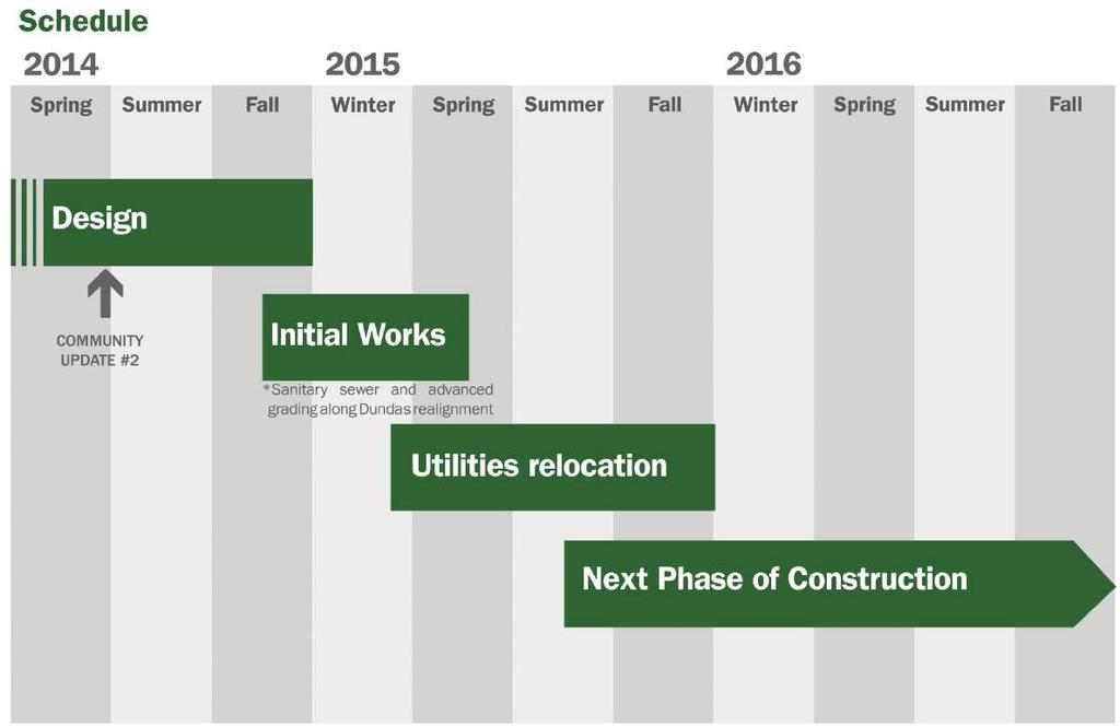
35 Underground Assemblies 10. Growing Medium
36 Underground Assemblies 11. Completed Soil Trench

37 Underground Assemblies 12.Granular Fill
38 Underground Assemblies 13. Concrete
39 14.Pavers Underground Assemblies
40 Underground Assemblies 15. Bike Lane
41 16.Planters Underground Assemblies
42 17.Trees Underground Assemblies

43 Underground Assemblies 18. Street Furniture
44 Schedule
45 Initial Works Fall 2014 Advanced grading and the installation of sanitary sewer along the Dundas Street Realignment Closure and removal of existing Kipling NB to Bloor EB Ramp and NB Bus Loop to Kipling NB
46 Initial Works Traffic / Transit Impacts
47 Future Construction Stages Stage 1 Build: Dundas Street (East of Kipling) Road A Road B Reconstruct: Bus Loop Ramp Bloor Street (East of Dunbloor)
48 Future Construction Stages Stage 2 Build: Dundas Street (West of Kipling) Reconstruct : Viking Lane Beamish Road Bloor Street (Dunbloor to Kilping) Dundas Street
49 Future Construction Stages Stage 3 Reconstruct: Kipling Avenue
50 Next Steps Start Initial Construction Works Fall 2014 Finalize Detail Design for Future Construction Fall 2014 Initiate Utility Relocations Winter 2014/Spring 2015 Start Next Phase of Construction Summer 2015 Projected Construction Duration 3 4 Years
51 Next Steps Project Website: toronto.ca/sixpoints For further information and to provide comments, please contact: Mike Logan Public Consultation Unit City of Toronto
Etobicoke Centre Public Space & Streetscape Plan
 Etobicoke Centre Public Space & Streetscape Plan Final Report October, 2011 MBTW GHD Urban Strategies Inc. MBTW GHD Table of Contents 1.0 Introduction 1 2.0 History & Context 5 3.0 Assessing the Centre
FANSHAWE PARK ROAD/RICHMOND STREET INTERSECTION IMPROVEMENTS. PUBLIC INFORMATION CENTRE 2 June 16, 2016
 FANSHAWE PARK ROAD/RICHMOND STREET INTERSECTION IMPROVEMENTS Municipal Class Environmental Assessment PUBLIC INFORMATION CENTRE 2 June 16, 2016 ACCESSIBILITY Under the Accessibility Standards 2015 for
CHAPTER 5: GUIDING PRINCIPLES
 CHAPTER 5: GUIDING PRINCIPLES The following 10 principles were developed based on public consultation, planning policy and the background analysis conducted during Phase 1. The Guiding Principles significantly
Welcome. Walk Around. Talk to Us. Write Down Your Comments
 Welcome This is an information meeting introducing the applications for proposed redevelopment of the Yorkdale Shopping Centre site at 3401 Dufferin Street and 1 Yorkdale Road over the next 20+ years,
Glen Road Pedestrian Bridge Environmental Assessment
 Glen Road Pedestrian Bridge Environmental Assessment Presentation to Design Review Panel July 18, 2017 Glen Road Pedestrian Bridge Class Environmental Assessment STUDY AREA Bloor Street East Streetscape
Clairtrell Area Context Plan
 Clairtrell Area Context Plan March 2005 Urban Development Services City Planning Contents 1. Introduction... 4 2. Development Structure... 6 2.1 Streets... 7 2.1.1 Sheppard Avenue and Bayview Avenue...
Bloor St. W. Rezoning - Preliminary Report
 STAFF REPORT ACTION REQUIRED 1638-1644 Bloor St. W. Rezoning - Preliminary Report Date: April 1, 2008 To: From: Wards: Reference Number: Toronto and East York Community Council Acting Director, Community
Lambeth Main Street Streetscape Improvements
 Lambeth Main Street Streetscape Improvements Open House October 5th, 2017 Agenda 1. Introduction 2. Project Background 3. Context 4. Project Objectives 5. Design Principles & Approach 6. Streetscape Design
Scope of Services. River Oaks Boulevard (SH 183) Corridor Master Plan
 Corridor Master Plan") Scope of Services River Oaks Boulevard (SH 183) Corridor Master Plan PROJECT AREA The project area consists of the River Oaks Boulevard (SH 183) corridor bounded by SH 199 at the northern end and the Trinity
Scope of Services River Oaks Boulevard (SH 183) Corridor Master Plan PROJECT AREA The project area consists of the River Oaks Boulevard (SH 183) corridor bounded by SH 199 at the northern end and the Trinity
St. Clair Avenue West Area Transportation Master Plan
 1 (Between Keele Street and Old Weston Road) Public Information Centre 1 December 2, 2015 2 Welcome Welcome to the first Public Information Centre for the St. Clair Avenue West Area. The panels will present
Toronto Complete Streets Guidelines
 Toronto Complete Streets Guidelines 108 110 7.1 Green Infrastructure Design Principles 112 7.2 Context-Sensitive Green Streets 114 7.3 Key Green Street Elements Green infrastructure refers to natural and
Tyvola & Archdale Transit Station Area Plan. May 15, 2008
 Tyvola & Archdale Transit Station Area Plan First Public Meeting May 15, 2008 Presentation Outline 1. Purpose and Process 2. Station Area Overview 3. Plan Recommendations Vision Land Use Transportation
Fifth and Detroit Street Design May 2017 Capital Improvements Committee. DOWNTOWN Street Design
 1 Fifth and Detroit Street Design May 2017 Capital Improvements Committee Agenda 2 Review Street Configuration Prior Meeting Review Outreach Synopsis Functional Street Design Refinements Curb Edge, Turning
TORONTO COMPLETE STREETS GUIDELINES
 TORONTO COMPLETE STREETS GUIDELINES Presentation by Fiona Chapman, Manager, Pedestrian Projects Public Realm Section, Transportation Services, City of Toronto June 2017 PURPOSE OF THE PROJECT To develop
PUBLIC MEETING April, 20161
 PUBLIC MEETING April, 20161 The Study Area Study Area Focus Area Corridor Neighbourhoods 2 Today s Presentation This material is aimed at providing viewers with enough background to be able to think about
SCARBOROUGH SUBWAY EXTENSION. Scarborough Subway Extension. Final Terms of Reference
 Scarborough Subway Extension Final Terms of Reference 1 1.0 Introduction and Background 1.1 Introduction Toronto City Council recently confirmed support for an extension of the Bloor-Danforth Subway from
1.0 Purpose of a Secondary Plan for the Masonville Transit Village
 Report to Planning and Environment Committee To: Chair and Members Planning & Environment Committee From: John M. Fleming Managing Director, Planning and City Planner Subject: Masonville Transit Village
I-95 Girard Avenue Interchange Near Neighbors Meeting. Project Status
 I-95 Girard Avenue Interchange Project Status Construction is underway for Phase 1 and 2. Phase 3 construction will begin early 2014. Overall Project Area and Schedule GR0: Completed GR0: Completed in
Humber Bay Shores Precinct Plan Final Report
 STAFF REPORT ACTION REQUIRED Humber Bay Shores Precinct Plan Final Report Date: May 21, 2010 To: From: Wards: Reference Number: Etobicoke York Community Council Director, Community Planning, Etobicoke
This Review Is Divided Into Two Phases:
 Semiahmoo Town Centre Review The purpose of this review: To review the Semiahmoo Town Centre Concept Plan, originally approved in 1993, to ensure that this centre will continue to serve the needs of South
CITY OF VAUGHAN D R A F T YONGE STREET STUDY. June 2008 YOUNG + WRIGHT /IBI GROUP ARCHITECTS DILLON CONSULTING LTD.
 CITY OF VAUGHAN June 2008 YOUNG + WRIGHT /IBI GROUP ARCHITECTS GHK SUSTAINABILITY INTERNATIONAL + LIVABILITY (CANADA) LTD. = COMMUNITY VALUE DILLON CONSULTING LTD. Public Open House Tonight s Meeting WELCOME
Tyvola & Archdale Transit Station Area Plan. June 5, 2008
 Tyvola & Archdale Transit Station Area Plan Second Public Meeting June 5, 2008 Presentation Outline 1. Purpose and Process 2. Station Area Overview 3. Plan Recommendations 4. Comments Received and Proposed
Project Status. Construction is underway for Phase 3. Overall Project Area and Schedule. Schedule of Current Construction Phases.
 I-95 Avenue Interchange Project Status Construction is underway for Phase 3. Overall Project Area and Schedule Phase 0: Completed 2010 Section GR0: Completed in Fallin 2010 Phase 2: Completed Section GR2:
McCowan Precinct Plan Study Background & Deliverables
 1 DRAFT & WITHOUT PREJUDICE McCowan Precinct Plan Study Background & Deliverables In September, 2011, City Planning (Scarborough District) began a study of an area within the Scarborough Centre, identified
Main Street Reconstruction From Ninth Line to Stouffer Street. Town of Whitchurch-Stouffville. Public Information Centre
 Main Street Reconstruction From Ninth Line to Stouffer Street Town of Whitchurch-Stouffville Public Information Centre November 23, 2016 4:30 to 6:00 pm & 7:00 to 8:00 pm 6240 Main Street, Stouffville
Downtown Streetscape Manual & Built Form Standards
 City of Guelph Downtown Streetscape Manual & Built Form Standards July 2014 Prepared by Brook McIlroy Inc. in association with Unterman McPhail Associates and McCormick Rankin Inc. City of Guelph Downtown
2040 Long Range Transportation Plan
 2040 Long Range Transportation Plan Adopted: April 15, 2013 APPENDIX D HIGHWAY NEEDS PLAN PROJECTS FREDERICKSBURG Existing and Committed Projects Fall Hill Avenue/Mary Washington Blvd. (Fredericksburg)
GLEN ROAD PEDESTRIAN BRIDGE ENVIRONMENTAL ASSESSMENT STUDY PUBLIC INFORMATION CENTRE #2 OCTOBER 24, 2017
 GLEN ROAD PEDESTRIAN BRIDGE ENVIRONMENTAL ASSESSMENT STUDY PUBLIC INFORMATION CENTRE #2 OCTOBER 24, 2017 Glen Road Pedestrian Bridge Class Environmental Assessment 1 WELCOME! Welcome to the second Public
TRANSPORTATION COMMITTEE
 TRANSPORTATION COMMITTEE CITY OF OTTAWA Ministry of Transportation Detailed Design Assignment G.W.P.# 4058-01-00 Highway 417 (Ottawa Queensway) Widening & Rehabilitation from Maitland Avenue to Island
SFMTA PHELAN LOOP AND PUBLIC PLAZA PHELAN OCEAN AVENUE
 SFMTA Municipal Transportation Agency Image: a bus in front of the Palace of the Legion of honor SFMTA PHELAN LOOP AND PUBLIC PLAZA PHELAN AVENUE @ OCEAN AVENUE Community Meeting May 23, 2012 San Francisco,
1 Metrolinx overview. Mission We connect our communities. Vision Getting you there better, faster and easier
 Mission We connect our communities Vision Getting you there better, faster and easier Values Play as a team Think forward Serve with passion 1 Metrolinx overview go transit, up express, presto Serve a
South Yonge Street Corridor
 South Yonge Street Corridor Streetscape Master Plan Study Draft Final Executive Summary Prepared by: January 2012 In Partnership with: Introduction The Future... Yonge Street is at the forefront of York
3. Urban Design in the Central Area
 3. Urban Design in the Central Area The Central Area Planning and Design Group assumes the responsibility to promote high quality urban and architectural design in the Central Area, plan and ensure the
BROADWAY-ARBUTUS POLICIES. Adopted by City Council on July 7, NOTE: To be considered in combination with applicable guidelines
 50 City of Vancouver Land Use and Development Policies and Guidelines Community Services, 453 W. 12th Ave Vancouver, BC V5Y 1V4 F 873.7344 fax 873.7060 planning@city.vancouver.bc.ca BROADWAY-ARBUTUS POLICIES
Bloor Street East Potential Ravine Portal Overlook and Access Passage to the Rosedale Valley and Don River Valley Ravine, Toronto, Canada
 TRANSFORMATIVE IDEA 2. GREAT STREETS Bloor Street Christie Pits Park Bloor St Spadina Ave Bathurst St Shaw St 1 Recognize the significant public realm improvements along Bloor Street and extend and enhance
Redevelopment of Ajax Plaza Area Public Open House Meeting February 19, 2015 Questions and Answers
 Redevelopment of Ajax Plaza Area Public Open House Meeting February 19, 2015 Questions and Answers Redevelopment of Ajax Plaza Area Why is the redevelopment of the Ajax Plaza important to the revitalization
Toronto Complete Streets Guidelines
 c. DTAH 58 60 3.1 70 3.2 Performance Measurement 71 3.3 Exceptions Chapter 3 describes the five general steps in the street design process. Not all projects follow these steps, as the number of steps and
Broadway District Specific Plan. Community Workshop #2 February 23,2016
 Broadway District Specific Plan Community Workshop #2 February 23,2016 1 Agenda Introductions Project Progress Status Upcoming Milestones Emerging Framework Land Use Urban Design Circulation Infrastructure
SHERIDAN PARKING STRUCTURE PUBLIC INFORMATION MEETING November 11, :00 pm - 8:00 pm
 SHERIDAN PARKING STRUCTURE PUBLIC INFORMATION MEETING November 11, 2010 6:00 pm - 8:00 pm 1 Project Area 2 Sheridan Parking Structure RTD Ownership 3 Project Elements Structure and amenities include: 1.
PROPOSED REDEVELOPMENT OF THE GLEN ABBEY GOLF CLUB. STREETSCAPE DESIGN STUDY (excerpt from the Urban Design Brief) TOWN OF OAKVILLE.
 TOWN OF OAKVILLE.") PROPOSED REDEVELOPMENT OF THE GLEN ABBEY GOLF CLUB STREETSCAPE DESIGN STUDY (excerpt from the Urban Design Brief) TOWN OF OAKVILLE OCTOBER, 2016 for 2.4.2 STREETS Streets are the single largest component
PROPOSED REDEVELOPMENT OF THE GLEN ABBEY GOLF CLUB STREETSCAPE DESIGN STUDY (excerpt from the Urban Design Brief) TOWN OF OAKVILLE OCTOBER, 2016 for 2.4.2 STREETS Streets are the single largest component
Scarborough Centre Transportation Master Plan Final Report
 REPORT FOR ACTION Scarborough Centre Transportation Master Plan Final Report Date: April 11, 2018 To: Scarborough Community Council From: Director Transit and Transportation Planning and Director Community
John M. Fleming Managing Director, Planning and City Planner. Old East Village Dundas Street Corridor Secondary Plan Draft Terms of Reference
 Report to Planning and Environment Committee To: From: Subject: Chair and Members Planning & Environment Committee John M. Fleming Managing Director, Planning and City Planner Old East Village Dundas Street
Bank Street Secondary Plan
 1.1 Introduction The is a guide to the long term design and development of the portion of Bank Street between Riverside Drive and Ledbury Park, and provides direction on land use, built form, design, parking,
Laird in Focus Community Information Session
 Laird in Focus Community Information Session Tuesday, December 5, 2017 St. Anslem Catholic School, 182 Bessborough Drive Session 1: 5:30 pm - Presentation and Question and Answer Period 6:15 pm - Breakout
July 12, Columbus City Council City Hall 90 West Broad Street Columbus, OH RE: I-70/71 Columbus Crossroads Project
 OHIO DEPARTMENT OF TRANSPORTATION DISTRICT 6 400 EAST WILLIAM STREET DELAWARE, OHIO 43015 800.372.7714 Columbus City Council City Hall 90 West Broad Street Columbus, OH 43215-9015 RE: I-70/71 Columbus
I-70/71 Innerbelt Project
 I-70/71 Innerbelt Project Project Progress Meeting and Design Enhancement Update November 9, 2009 Ohio Department of Transportation MS Consultants MSI Design Overview of Presentation 1. Recap Recent Project
Director, Community Planning, Toronto and East York District
 Lower Yonge Precinct Plan Update STAFF REPORT ACTION REQUIRED Date: October 16, 2012 To: From: Wards: Reference Number: Toronto and East York Community Council Director, Community Planning, Toronto and
38 Queen s University Campus Master Plan Part 1
 38 Queen s University Campus Master Plan Part 1 46 The Campus at the City Scale Chapter 4 The Campus at the City Scale 39 Queen s is an urban University centrally located in Kingston. Decisions made by
Adelaide Street / Canadian Pacific Railway (CPR) Grade Separation Class Environmental Assessment. Public Information Centre 3
 Grade Separation Class Environmental Assessment. Public Information Centre 3") 1 Adelaide Street / Canadian Pacific Railway (CPR) Grade Separation Study Process and Purpose of PIC 3 2 Study Commencement February 2016 Phase 1: Problem and Opportunity Identify problems and opportunities
1 Adelaide Street / Canadian Pacific Railway (CPR) Grade Separation Study Process and Purpose of PIC 3 2 Study Commencement February 2016 Phase 1: Problem and Opportunity Identify problems and opportunities
Written Statement for Keizer Station Area B Amendment. Master Plan Amendment for Keizer Station Area B GENERAL INFORMATION
 Written Statement for Keizer Station Area B Amendment Applicant: City of Keizer Request: Master Plan Amendment for Keizer Station Area B DATE: June 2017 GENERAL INFORMATION A. OWNER: The City of Keizer
Waverley West B Secondary Planning Process. Open House South Pointe School April 25, 2018
 averley est B Secondary Planning Process South Pointe School April 25, 2018 averley est B Secondary planning process open house Please review the boards and provide your feedback. 1 The Role of a Secondary
ALTERNATIVES. NCDOT made an early decision to first determine how to build the project (construction method) followed by what to build (alternatives).
 followed by what to build (alternatives).") III. ALTERNATIVES A. CONSTRUCTION METHOD ALTERNATIVES NCDOT made an early decision to first determine how to build the project (construction method) followed by what to build (alternatives). One of the
III. ALTERNATIVES A. CONSTRUCTION METHOD ALTERNATIVES NCDOT made an early decision to first determine how to build the project (construction method) followed by what to build (alternatives). One of the
I-90 Mississippi River Bridge & Interchange Project
 I-90 Mississippi River Bridge & Interchange Project Presentation Outline I. Background: Context & Need for Project II. Preferred Alternative Overview III. Project Development IV. Project Management Tools
Mary Hills Nature Area. Roadway Lighting. The Minneapolis Clinic of Neurology Courage Kenny Rehabilitation Institute
 PUBLIC REALM IMPROVEMENTS Mary Hills Nature Area Enhanced Programming Glenview Terrace Valley View Roadway Lighting Enhanced Streetscape Trail Lighting / Roadway Lighting Wayfinding Public Art The Minneapolis
Complete Street and the EA Process. Queen Street Corridor- Brampton Golden Mile
 Complete Street and the EA Process. Queen Street Corridor- Brampton Golden Mile Contents A. Vision B. Overview of Existing Conditions C. Queen Street Complete Street Criteria D. A quick look at the Queen
UTSC SECONDARY PLAN COMMUNITY OPEN HOUSE
 WELCOME TO THE UTSC SECONDARY PLAN COMMUNITY OPEN HOUSE 1 Welcome to the first Community Open House for the UTSC Secondary Plan. Hosted by the University of Toronto Scarborough (UTSC), the following panels
Clay Street Bridge Replacement Project
 Clay Street Bridge Replacement Project Frequently Asked Questions (FAQs) No. 2 April 4, 2018 The project is located in downtown Placerville on Clay Street between US Highway 50 and Main Street and Cedar
Public input has been an important part of the plan development process.
 Lakewood s Comprehensive Plan recognizes that transportation helps shape the community, and that the way the community provides for the safe and efficient movement of people affects the character of the
7.5 Impacts on the Section 4(f) Properties
 Properties") constructive use, such as noise, air quality and visual impacts were also assessed. It was determined that this project would not introduce changes of an external nature that would affect the recreational
constructive use, such as noise, air quality and visual impacts were also assessed. It was determined that this project would not introduce changes of an external nature that would affect the recreational
Executive Summary. NY 7 / NY 2 Corridor
 Executive Summary NY 7 / NY 2 Corridor Transportation and Land Use Study December 2005 Prepared for: Town of Colonie Capital District Transportation Committee Prepared by: Introduction: Land use decisions
13 THORNHILL YONGE STREET STUDY IMPLEMENTATION CITY OF VAUGHAN OPA 669 AND TOWN OF MARKHAM OPA 154
 13 THORNHILL YONGE STREET STUDY IMPLEMENTATION CITY OF VAUGHAN OPA 669 AND TOWN OF MARKHAM OPA 154 The Planning and Economic Development Committee recommends the adoption of the recommendations contained
WHAT IS THE PURPOSE OF THE OPEN HOUSE?
 WHAT IS THE PURPOSE OF THE OPEN HOUSE? OPEN HOUSE PURPOSE The purpose of the open house is to provide an update on the study process and introduce the preliminary concept alternatives. The open house provides
St. Clair Avenue West Transit Improvements. Class Environmental Assessment. Urban Design Summary
 St. Clair Avenue West Transit Improvements Class Environmental Assessment Urban Design Summary September 2004 Table of Contents 1 URBAN DESIGN PURPOSE & OBJECTIVES... 1 2 ST. CLAIR WEST URBAN DESIGN CONTEXT...
MURRAY CENTRAL STATION MASTER PLAN Central Station Area of Influence and Site Analysis
 CENTRAL STATION MASTER PLAN Central Station Area of Influence and Site Analysis OVERVIEW Planned Fire Station TAYLORSVILLE A thorough Site Analysis was conducted to ensure planning and design concepts
REQUEST Current Zoning: O-15(CD) (office) Proposed Zoning: TOD-M(CD) (transit oriented development mixed-use, conditional)
 (office) Proposed Zoning: TOD-M(CD) (transit oriented development mixed-use, conditional)") Rezoning Petition 2016-117 Zoning Committee Recommendation January 4, 2017 REQUEST Current Zoning: O-15(CD) (office) Proposed Zoning: TOD-M(CD) (transit oriented development mixed-use, conditional) LOCATION
Rezoning Petition 2016-117 Zoning Committee Recommendation January 4, 2017 REQUEST Current Zoning: O-15(CD) (office) Proposed Zoning: TOD-M(CD) (transit oriented development mixed-use, conditional) LOCATION
Civic Center District
 Civic Center District The Civic Center district is the civic and social heart of Warrenville, containing such public buildings as the City Hall, Warrenville Public Library, Police Station, Park District
PROPOSED IMPROVEMENTS
 IV. PROPOSED IMPROVEMENTS The proposed improvements for each alternative carried forward are discussed below. A. FUNCTIONAL CLASSIFICATION AND ROADWAY CROSS-SECTIONS The classifications of the roadways
Tonight s Agenda. Summary Presentation Open House. Group Discussion Next Steps: online community wide survey
 Community Open House February 22, 2018 Tonight s Agenda Summary Presentation Open House Station 1: Project Overview and Community Input Station 2: Draft Vision and Guiding Principles Station 3: Western,
STREETSCAPE MANUAL ONLINE TRAINING SESSION 1: Background
 TRAINING SESSION 1: The Urban Design Streetscape Manual is a reference tool developed to help implement City policy and guide the design, construction and maintenance of streetscape improvements in Toronto.
the west loop HOME TO 5,000 NEW DOGS
 the west loop the west loop HOME TO 5,000 NEW DOGS the west loop HOME TO 5,000 NEW DOGS AND 20,000 NEW RESIDENTS outline: the west loop now the vision how do we get there? opportunity LEVERAGE TRANSIT
GOLDEN MILE SECONDARY PLAN. Community Consultation Meeting #3 June 26, 2018
 GOLDEN MILE SECONDARY PLAN Community Consultation Meeting #3 June 26, 2018 Meeting Overview 1. Introduction 2. Principles + Vision 3. Street + Block Alternatives 4. Parks + Open Space Alternatives 5. Land
Relief Line Project Assessment
 Relief Line Project Assessment Public Information Centre April 5, 2017 Tonight s Meeting PURPOSE To review the preferred alignment for the Local Segment. AGENDA 6:30 Open House 7:00 Presentation / Discussion
2016 REVISIONS COMMENT FORM RULES AND REGULATIONS FOR CONSTRUCTION IN THE PUBLIC WAY COMMENT PERIOD: JUNE 1 TO JUNE 30, 2015
 AGENCY: 2016 REVISIONS COMMENT FORM Section Title Number Chapter 1 Introduction Comment 1.1 CDOT Mission Statement 1.2 Purpose of Rules and Regulations for Construction in the Public Way 1.3 Chicago Department
Dundas Place Flexible Street Public Information Centre
 WELCOME TO THE DUNDAS PLACE DESIGN REVEAL Dundas Place Flexible Street Public Information Centre November 8, 2017 This project is funded by the City of London with support from the Government of Canada
3 MARKHAM NORTH-SOUTH LINK CORRIDOR PUBLIC TRANSIT IMPROVEMENTS ENVIRONMENTAL ASSESSMENT UPDATE
 3 MARKHAM NORTH-SOUTH LINK CORRIDOR PUBLIC TRANSIT IMPROVEMENTS ENVIRONMENTAL ASSESSMENT UPDATE The Rapid Transit Public/Private Partnership Steering Committee recommends the adoption of the recommendations
GREENING THE BOULEVARD Master Plan Concepts for Venice Boulevard between Lincoln and Sawtelle
 GREENING THE BOULEVARD Katherine Spitz Associates Inc. 4212½ Glencoe Avenue Marina Del Rey, CA 90292 310 574 4460 Fax 574 4462 January 2008 Table of Contents Overview Proposed Design Improvements Illustration
Official Community Plan Bylaw No. 4360, 2004, Amendment Bylaw No. 4897, 2016 (Sewell s Landing)
") District of West Vancouver Official Community Plan Bylaw No. 4360, 2004, Amendment Bylaw No. 4897, 2016 (Sewell s Landing) Effective Date: 1089612v1 District of West Vancouver Official Community Plan Bylaw
District of West Vancouver Official Community Plan Bylaw No. 4360, 2004, Amendment Bylaw No. 4897, 2016 (Sewell s Landing) Effective Date: 1089612v1 District of West Vancouver Official Community Plan Bylaw
Coxwell Station Easier Access
 Coxwell Station Easier Access Construction Update and Public Art Concept Danforth Mennonite Church 1 Coxwell Station Easier Access Strathmore Blvd Looking North Street Level Elevator E2 Concourse Outline
Public Consultation Summary: Lakeview Place Making Workshop January 30, 2008.
 Page 1 of 11 Public Consultation Summary: Lakeview Place Making Workshop January 30, 2008. 1.0 Introduction: On January 30, 2008 the City of Mississauga, in conjunction with the consulting team of Brook
STREETSCAPE MANUAL ONLINE TRAINING SESSION 2: Searching the Manual
 TRAINING SESSION 2: The Urban Design Streetscape Manual is a reference tool developed to help implement City policy and guide the design, construction and maintenance of streetscape improvements in Toronto.
Eglinton West/Allen Road Station Potential South Side Entrance Options. Online Consultation April 2 nd to April 16 th
 Eglinton West/Allen Road Station Potential South Side Entrance Options Online Consultation April 2 nd to April 16 th Eglinton West/Allen Road Station Consultation #1 Most common comment: south side entrance
Sheridan Boulevard S TAT I O N A R E A P L A N S H E R I D A N B O U L E VA R D S TAT I O N A R E A P L A N
 Sheridan Boulevard S TAT I O N A R E A P L A N 1 City of Lakewood Adopted November, 2006 S H E R I D A N B O U L E VA R D S TAT I O N A R E A P L A N The Vision The City of Lakewood s overall vision is
Transit-supportive development and city-building
 Photo: Michael Hiemstra (CC BY 2.0) Transit-supportive development and city-building Brief 3: Tools for building infrastructure and policy conditions Building the policy and infrastructure conditions Municipalities
ROAD CLOSURE AND LAND USE AMENDMENT SILVER SPRINGS (WARD 1) NORTHEAST OF NOSEHILL DRIVE NW AND SILVER SPRINGS ROAD NW BYLAWS 2C2018 AND 29D2018
 NORTHEAST OF NOSEHILL DRIVE NW AND SILVER SPRINGS ROAD NW BYLAWS 2C2018 AND 29D2018") Page 1 of 19 EXECUTIVE SUMMARY This application proposes redesignating two parcels in the community of Silver Springs from Special Purpose Future Urban Development (S-FUD) District and undesignated road
Page 1 of 19 EXECUTIVE SUMMARY This application proposes redesignating two parcels in the community of Silver Springs from Special Purpose Future Urban Development (S-FUD) District and undesignated road
COUNCIL ATTACHMENT 2 HIGHWAY 7 CORRIDOR AND VAUGHAN NORTH-SOUTH LINK
 COUNCIL ATTACHMENT 2 HIGHWAY 7 CORRIDOR AND VAUGHAN NORTH-SOUTH LINK Welcome! The purpose today is to: Present the Study Background; Describe Alignment Alternatives Analyzed; Present the Evaluation of
Trafalgar Road Corridor Planning Study Open House
 Trafalgar Road Corridor Planning Study Open House June 24, 2013 6:30-8:30 p.m. Oakville & Trafalgar Rooms Overview The Livable Oakville Plan identifies the lands along Trafalgar Road, between the QEW and
PORT WHITBY COMMUNITY
 PORT WHITBY COMMUNITY SECONDARY PLAN UPDATE COMMUNITY IMPROVEMENT PLAN URBAN DESIGN GUIDELINES September 2015 DRAFT PROPOSED AMENDMENT NUMBER # to the Whitby Official Plan PURPOSE: The intent of this Amendment
Fifth and Detroit Street Design/South University Update Capital Improvement Committee Meeting
 1 Fifth and Detroit Street Design/South University Update Capital Improvement Committee Meeting Kick-off Meeting Agenda 2 1. Introductions 2. Update on South University 3. Fifth and Detroit-project scope
Bridge Type Assessment and Evaluation
 16M-01410-01 (3216026) Glen Road Pedestrian Bridge EA Study Bridge Type Assessment and Evaluation Factor Group/Criteria Alternative 1: Steel girder with two inclined steel legs Alternative 2: Steel girder
Regency Developments. Urban Design Brief. Holyrood DC2 Rezoning
 Regency Developments Urban Design Brief Holyrood DC2 Rezoning Stantec Consulting Ltd. 7-31-2017 1. Overview Regency Developments intends to rezone the lands located at 8510 and 8511 93 Avenue, within the
DRAFT Northeast Quadrant of Kipling Avenue and Highway 7 DRAFT AUGUST 29, Goals Land Use. The goals of this Plan are to:
 AUGUST 29, 2017 12.15 Northeast Quadrant of Kipling Avenue and Highway 7 12.15.1 Goals 12.15.2 Land Use The goals of this Plan are to: 12.15.2.1 General Provisions: a) Ensure the development of a compact
Illustration of Eastlake Farmer s Cooperative Grain Elevator. Chapter 5: implementation 5-1
 Illustration of Eastlake Farmer s Cooperative Grain Elevator Chapter 5: implementation 5-1 chapter 5: implementation Introduction The Eastlake Subarea Plan includes a wide range of recommendations intended
South fields. Community Architectural Design Guidelines. The Planning Partnership
 South fields Community Architectural Design Guidelines The Planning Partnership Table Of Contents Table of Contents 1.0 GUIDING PRINCIPLES 1.1 Function of Architectural Design Guidelines 1.2 Administration
Cleveland Park Streetscape and Drainage Improvement Project 1
 Cleveland Park Streetscape and Drainage Improvement Project 1 Urban Context Washington, D.C. Connecticut Avenue Cleveland Park Streetscape and Drainage Improvement Project 2 Neighborhood Context Contributing
SCARBOROUGH RAPID TRANSIT ENVIRONMENTAL PROJECT REPORT CHAPTER 2 PROJECT DESCRIPTION. Table 2-4: North Segment Alignment Analysis 2-21
 Table 2-4: North Segment Alignment Analysis 2-21 SCARBOROUGH RAPID TRANSIT Based on the above analysis (detailed analysis is contained in Appendix A-4), North Alignment 3 is preferred because it: Has the
Planning for TOD Implementation at a Corridor Scale
 Planning for TOD Implementation at a Corridor Scale Catherine Cox Blair, Reconnecting America Presentation to DRCOG and the Sustainable Communities Initiative May 14, 2012 What is Reconnecting America?
International Blvd. TOD Plan Public Workshop #1
 International Blvd. TOD Plan Public Workshop #1 Add photos or project images September 21 and 22, 2010 Workshop Purpose Introduce the public to the Project Review and discuss the existing conditions analysis
Transportation. Strategies for Action
 Transportation A major priority for the Overlake Neighborhood is to develop a multimodal transportation system. To achieve this system, a balance has to be found among travel, circulation and access needs;
Yonge Eglinton Centre Urban Design Guidelines
 Yonge Eglinton Centre Urban Design Guidelines City Planning Urban Design January 2009 YONGE EGLINTON CENTRE INTRODUCTION.................................................... 1 GENERAL SITE PLAN OBJECTIVES......................................
THAT the attached Terms of Reference for the Thornhill Centre Street Study be approved.
 COMMITTEE OF THE WHOLE AUGUST 18, 2003 THORNHILL CENTRE STREET STUDY PLANNING FILE: 15.92 Recommendation The Commissioner of Planning recommends: THAT the attached Terms of Reference for the Thornhill