Welcome. Comprehensive Plan & Transportation Plan Open House November 7, 2012
|
|
|
- Tracey Hamilton
- 5 years ago
- Views:
Transcription
1 Welcome Comprehensive Plan & Transportation Plan Open House November 7, 2012
2 Agenda Proposed future land use plan Comprehensive Plan strategies Traffic forecasts Future traffic operations Possible future roadway improvements
3 Agenda Proposed future land use plan Comprehensive Plan strategies Traffic forecasts Future traffic operations Possible future roadway improvements
4 Proposed Future Land Use Plan Plan Methodology Identified land use classifications Summarized existing land use consumption Defined future planning area (one mile ETA) Calculated future land use consumption for 10% growth scenario Developed future land use scenarios for planning area Selected preferred future land use plan

5 Proposed Future Land Use Plan

6 Anticipated 2035 Development Areas
7 Agenda Proposed future land use plan Comprehensive Plan strategies Traffic forecasts Future traffic operations Possible future roadway improvements
8 Comprehensive Plan Strategies Plan Elements Land Use Community Facilities Housing Nature and the Environment Economic Development Transportation Historical and Cultural Resources
9 Comprehensive Plan Strategies Land Use Encourage varying density throughout the growth areas to develop a diverse housing stock. Life cycle housing choices Affordability Conservation Design Districts Manage growth in a way that provides for vibrant, walkable neighborhoods that are compatible with and connected to existing neighborhoods.
10 Comprehensive Plan Strategies Land Use Promote infill of existing vacant properties that fits within the context of the existing neighborhood. Focus on revitalization of the Downtown core. Utilize the future land use plan and growth phasing plan as guidance when working with homeowners and potential developers Expand the existing grid pattern into contiguous growth areas.

11 Comprehensive Plan Strategies Land Use Encourage the development of neighborhood commercial as residential development occurs outside of the city core to provide service to new neighborhoods. Adopt park dedication and open space requirements to enhance the quality of new growth areas.

12 Comprehensive Plan Strategies Community Facilities Future Municipal Facilities Plan for future service needs: Police Fire Public Works City Hall Other City Buildings Water Supply and Treatment Trash Collection and Solid Waste Management Streetlights Energy Sources Community Center

13 Comprehensive Plan Strategies Community Facilities Parks Develop strategies for park improvements and development of new parks Trails and Sidewalks Develop a Trail connection to Black s Grove Park Enhance multi-seasonal trails Promote usage by creating linkage between neighborhoods and utilizing wayfinding signage throughout the city. Require sidewalks on both sides of streets

14 Comprehensive Plan Strategies Community Facilities Recreation Facilities and Opportunities Promote use of new Wellness Center Seek opportunities for additional multi-seasonal recreation at existing park and recreation facilities. Adopt park dedication and open space requirements for new growth areas.

15 Comprehensive Plan Strategies Housing Create Diversity of Housing Choices Life Cycle Housing Focus on providing affordable housing for a variety of residents Develop design guidelines to preserve and enhance neighborhood character Identify neighborhood boundaries and involve the neighborhood on preparing neighborhood plans.


16 Comprehensive Plan Strategies Nature and the Environment Promote preservation of wooded and wetland areas by cataloging attributes and features, and encouraging conservation design for new development in or adjacent to those areas Increase the number of and access to Greenways, Open Spaces, and Vegetation within the City

17 Comprehensive Plan Strategies Nature and the Environment Vegetation Develop requirements for boulevard trees Promote tree planting incentives Encourage tree protection in new growth areas Develop energy efficiency policies for city facilities and functions. Explore solid waste and recycling procedures for new and updated practices and technologies. Establish parking lot landscaping requirements to provide aesthetic benefits and urban cooling effects of shade.

18 Comprehensive Plan Strategies Economic Development Support the Economic Development Corporation s efforts to attract new businesses to Wadena and retain existing ones. Encourage local business ownership. Increase the number of jobs that provide a living wage.
19 Comprehensive Plan Strategies Economic Development Promote Wadena s high quality of life, responsible work ethic, and location on major transportation corridors to attract more businesses and jobs. Maintain two-way communication between the City and M State regarding job needs, trends, and student work. Explore downtown revitalization programs and policies for Wadena s downtown.

20 Comprehensive Plan Strategies Historical and Cultural Resources Enhance historic preservation by cataloging historic sites. Identify sites for redevelopment in either a historic or non-historic manner. Respond to neighborhood concerns by establishing historic district zoning regulations. Celebrate cultural heritage and diversity Expand existing public art efforts. Build a sense of community through: Festivals and celebrations that embrace the seasons Creation of community gathering places
21 Agenda Proposed future land use plan Comprehensive Plan strategies Traffic forecasts Future traffic operations Possible future roadway improvements
22 Traffic Forecasts Travel Demand Model Developed a model to forecast average daily traffic using future land use and roadway assumptions Existing land use: Census and LEHD data (Year 2010) Future land use: 10% and 25% land use growth scenarios Incorporated data from the Wadena O-D study and existing turning movement data
23 Traffic Forecasts Highway Network Traffic Analysis Zones
24 Traffic Forecasts
25 Traffic Forecasts
26 Agenda Proposed future land use plan Comprehensive Plan strategies Traffic forecasts Future traffic operations Possible future roadway improvements


27 Future Traffic Operations Intersection operations Analyzed a.m. and p.m. peak hour conditions (LOS) Reviewed operational queue lengths and impacts at all key intersections Continue to operate at acceptable overall LOS during the a.m. and p.m. peak hour conditions Vehicles queue periodically during the peak hour through adjacent intersections (especially when trains pass through) Approximately 50 trains pass through today on a daily basis, which can take approximately 3 8 minutes for the queues to recover following a train passing through This could increase in the near future to 70, 90, 140 trains
 Future (70 trains) ADT Exposures ADT Exposures 2nd St SW 5,600 280,000 6,000 420,000 TH 71 10,400 520,000 11,300 791,000 1st St SE 4,600 230,000 5,000")
28 Future Traffic Operations Auto / Rail Conflicts Near or Exceeds MnDOT intersection exposure threshold of 300,000 auto / rail conflicts at the three crossings Location Existing (50 trains) Future (70 trains) ADT Exposures ADT Exposures 2nd St SW 5, ,000 6, ,000 TH 71 10, ,000 11, ,000 1st St SE 4, ,000 5, ,000
29 Agenda Proposed future land use plan Comprehensive Plan strategies Traffic forecasts Future traffic operations Possible future roadway improvements
30 Possible Future Roadway Improvements Subarea Studies 1. TH 29 Reroute and CR 75 Truck Route 2. Education Campus Area Safety Improvements 3. TH 29 Extension 4. Potential TH 10 Four-Lane Improvement 5. Potential Grade Separation Locations
31 Possible Future Roadway Improvements Subarea Studies 1. TH 29 Reroute and CR 75 Truck Route 2. Education Campus Area Safety Improvements 3. TH 29 Extension 4. Potential TH 10 Four-Lane Improvement 5. Potential Grade Separation Locations
32 Possible Future Roadway Improvements TH 29 Reroute Estimated vehicles per route Calculated travel time by route Estimated travel time savings Determined travel pattern shifts (route diversion curve) General Travel Pattern Average Travel Time(Seconds)* Percent Diversion to CR 75/TH 10 Corridor Corridor Travel (Est. ADT) Route 1 (Existing TH 29) 242 seconds --- 1,950 Route 2 (Existing CR 75/TH10) 302 seconds Route A (Reroute TH 29) 243 seconds 10 percent 1,750 Route B (Reroute CR 75/TH10) 283 seconds * Travel times for each route include intersection delays.

33 Possible Future Roadway Improvements
34 Possible Future Roadway Improvements CR 75 Truck Route Designation Reviewed MnDOT truck routes Estimated heavy commercials vehicles by route Verified future land use Determined truck travel pattern shifts Truck Travel Pattern Percent of total ADT Existing HCADT Future HCADT Route A (Existing TH 29) 10 percent Route B (Existing CR 75/TH10) Route A (Existing TH 29) 2.5 percent Route B (Truck Route CR 75) 7.5 percent
35 Possible Future Roadway Improvements
36 Possible Future Roadway Improvements Subarea Studies 1. TH 29 Reroute and CR 75 Truck Route 2. Education Campus Area Safety Improvements 3. TH 29 Extension 4. Potential TH 10 Four-Lane Improvement 5. Potential Grade Separation Locations
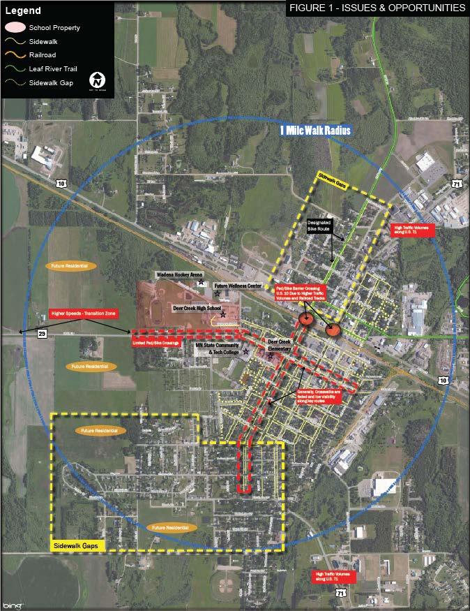
37 Possible Future Roadway Improvements Education Campus Area Safety Improvements Assessed safety and convenience of bike/ped facilities Defined issues and opportunities for facility improvements Recommended improvements Established action items and potential scheduling Action Step Cost Schedule Upgrade sidewalk crossings with high visibility markings (e.g. zebra or ladder styles) Install curb extensions (bump-outs) at Emerson Avenue, Colfax Avenue and Aldrich Avenue $ Ongoing $$ Mid- to Long-term Install centerline crossing signs at the schools $ Short-term Install advanced walk interval and countdown timers at Colfax Avenue/Jefferson Avenue and 2nd Street/TH 10 $$ Mid-term Railroad Crossing improvements at 2nd Street and Jefferson Avenue $$$ Long-term Improve sidewalk network ($80 - $110 per linear foot) $ - $$$ Ongoing Establish a dedicated bike lane along 2nd Street $$ Mid-term Install wayfinding signs along 2nd Street and Colfax Avenue (cost may vary depending on the number and size of signs) $ - $$ Mid-term Conduct a school speed zone study $ Short-term Please note: The cost of a project may vary depending on the size and scale of the improvement. Legend Schedule Short Term: 1 3 years Mid Term: 3 5 years Long term: 5 10 years Cost $ Low Cost ($0 - $20,000) $$ Medium Cost ($20,000 - $80,000) $$$ High Cost ($80,000+)

38 Possible Future Roadway Improvements
39 Possible Future Roadway Improvements Subarea Studies 1. TH 29 Reroute and CR 75 Truck Route 2. Education Campus Area Safety Improvements 3. TH 29 Extension 4. Potential TH 10 Four-Lane Improvement 5. Potential Grade Separation Locations
40 Possible Future Roadway Improvements TH 29 Extension (Option 1) Extend Colfax Avenue from 4 th Street to TH 10, with new at-grade railroad crossing Remove south approach of TH 10 / 1 st Street SE, resulting in removal of at-grade railroad crossing Re-align CR 4 north approach with the TH 29 extension Identified the traffic shifts with this new alignment Volume is expected to decrease by ~ 2,000 vehicles/day at the TH 71 / TH 10 intersection Volumes along TH 10 between TH 71 and potential TH 29 / CR 4 intersection expected to decrease by 3,300 vehicles/day

41 Possible Future Roadway Improvements
42 Possible Future Roadway Improvements TH 29 Extension (Option 2) Extension of TH 29 further east along Colfax Avenue, connecting to TH 10 with new at-grade rail crossing (east of the north-south railroad spur) Re-align CR 4 north approach with TH 29 extension Results in similar traffic volume shifts as Option 1 Provides additional development opportunity on the eastern edge of town Construction of the north-south roadway connection to Homecrest Avenue could be omitted

43 Possible Future Roadway Improvements
44 Possible Future Roadway Improvements Subarea Studies 1. TH 29 Reroute and CR 75 Truck Route 2. Education Campus Area Safety Improvements 3. TH 29 Extension 4. Potential TH 10 Four-Lane Improvement 5. Potential Grade Separation Locations

45 Possible Future Roadway Improvements TH 10 Potential Four-Lane Improvement Conceptual alignment developed for four-lane roadway
46 Possible Future Roadway Improvements Subarea Studies 1. TH 29 Reroute and CR 75 Truck Route 2. Education Campus Area Safety Improvements 3. TH 29 Extension 4. Potential TH 10 Four-Lane Improvement 5. Potential Grade Separation Locations
47 Possible Future Roadway Improvements Potential Grade Separation Locations TH 10 grade separation conceptual alternatives Mitigate the auto / rail exposures adjacent to TH 10 CSAH 20 and CR 169 (west corridor) TH 71 and TH 10 (central corridor) TH 29 and CR 4 at TH 10 (east corridor) Strictly concepts for consideration Conduct additional analysis and assessment in order to understand full impacts, cost, etc.

48 Possible Future Roadway Improvements CSAH 20 and CR 169 (west corridor)

49 Possible Future Roadway Improvements TH 71 and TH 10 (central corridor)

50 Possible Future Roadway Improvements TH 29 and CR 4 at TH 10 (east corridor)
51 Questions?
CHAPTER 7: Transportation, Mobility and Circulation
 AGLE AREA COMMUNITY Plan CHAPTER 7 CHAPTER 7: Transportation, Mobility and Circulation Transportation, Mobility and Circulation The purpose of the Transportation, Mobility and Circulation Chapter is to
City of Royalton Comprehensive Land Use Plan 2005 to Revision February 8, 2011
 City of Royalton Comprehensive Land Use Plan 2005 to 2015 2011 Revision February 8, 2011 PART ONE: INTRODUCTION TO THE COMPREHENSIVE PLAN 1.0 Purpose and Introduction The Comprehensive Land Use Plan provides
Description of Preferred Alternative
 Chapter 2 Description of Preferred Alternative 2.1 Introduction This chapter of the programmatic Sammamish Town Center Sub-area Plan Final EIS provides a more detailed description of the Preferred Alternative
The University District envisions, in its neighborhood
 Envisioning the University District Link Light Rail in Seattle s neighborhoods CIY OF SEALE CONCEP-LEVEL SAION AREA PLANNING RECOMMENDAION RESOLUION # 30165 EXHIBI L Vision 08.2000 he University District
SPRINGHILL LAKE TRANSIT VILLAGE
 Greenbelt Metro Area Sector Plan - Subarea Design Policies and Guidelines - Springhill Lake Transit Village 113 SPRINGHILL LAKE TRANSIT VILLAGE Residential Neighborhood and Village Center CONCEPT Springhill
Comprehensive Plan. Faribault, Minnesota. Hoisington Koegler Group Inc. Claybaugh Preservation Architecture Inc. Howard R. Green Company Bonz/REA
 Comprehensive Plan Faribault, Minnesota Adopted by the Faribault City Council July 8, 2003 prepared for: prepared by: Hoisington Koegler Group Inc. Claybaugh Preservation Architecture Inc. Howard R. Green
Implementation Guide Comprehensive Plan City of Allen
 Implementation Guide 2030 Comprehensive Plan City of Allen DRAFT 2015 Implementation Guide Allen 2030 Comprehensive Plan INTRODUCTION The Comprehensive Plan serves as a guide for the growth and development
Town Center (part of the Comprehensive Plan)
") Town Center (part of the Comprehensive Plan) Mercer Island Town Center Looking North (2014) In 1994, a year-long process culminated in a set of design guidelines and code requirements for the Town Center
Town Center (part of the Comprehensive Plan) Mercer Island Town Center Looking North (2014) In 1994, a year-long process culminated in a set of design guidelines and code requirements for the Town Center
CHAPTER 1. Ms. Guajardo s Class - Central Elementary CH 1 1
 INTRODUCTION CHAPTER 1 Ms. Guajardo s Class - Central Elementary CH 1 1 1.1 SETTING South Centre City is a linear corridor south of Downtown Escondido paralleling Centre City Parkway and South Escondido
The transportation system in a community is an
 7 TRANSPORTATION The transportation system in a community is an important factor contributing to the quality of life of the residents. Without a sound transportation system to bring both goods and patrons
Today Land & People. Northeast Nampa Gateway District. Employment. Land Use Characteristics. Demographics. Current Zoning
 Today Land & People Employment Major employers include Saint Alphonsus, the College of Western Idaho, the Auto Mall, Sorrento Lactalis and Walmart. 3,004 jobs in 2010 (COMPASS-CIM 2040 TAZ data) 4,345
CITY OF COLWICH COMPREHENSIVE PLAN LAND USE LAND USE 1
 LAND USE LAND USE 1 WHAT YOU WILL FIND IN THIS CHAPTER: Discussion of today s conditions and tomorrow s projections Discussion of challenges and opportunities Discussion of the environmental quality goals,
Committee Meeting: Downtown Today & Concept Refinement September 11, 2017
 Committee Meeting: Downtown Today & Concept Refinement September 11, 2017 AGENDA 1. Brief Input Update 2. Comprehensive Plan Principles 3. Downtown Today 4. Concept Updates 5. Future Schedule What is a
Atlanta BeltLine Subarea 3 Master Plan Update
 Atlanta BeltLine Subarea 3 Master Plan Update April 14, 2018 Workshop Meeting 1 22 miles, connecting 45 neighborhoods 22 MILES of transit 46 MILES of streetscapes and complete streets 33 MILES of urban
Transportation. Strategies for Action
 Transportation A major priority for the Overlake Neighborhood is to develop a multimodal transportation system. To achieve this system, a balance has to be found among travel, circulation and access needs;
Status Report: MD 355 Project
 Status Report: MD 355 Project OCTOBER 2006 M-NCPPC MONTGOMERY COUNTY PLANNING DEPARTMENT Summary of Community Comments, and break to the Results of the MD 355 Participation Session Brookside Gardens -
PLAN ELEMENTS WORKSHOP. April 5, 2016
 PLAN ELEMENTS WORKSHOP April 5, 2016 needs more housing. But there is no one-size fits-all solution. Every neighborhood has its own character. In some places, density is not only appropriate it is badly
BROOKHILL NEIGHBORHOOD MODEL ZONING MAP AMENDMENT PREFACE TO APPLICATION
 BROOKHILL NEIGHBORHOOD MODEL ZONING MAP AMENDMENT PREFACE TO APPLICATION June 15, 2015 Revised: August 1, 2016 I. VISION Brookhill is a proposed community based upon the principles of Albemarle County
Old Town Neighborhoods Plan. Choices Event Wednesday, December 9, 2015
 Old Town Neighborhoods Plan Choices Event Wednesday, December 9, 2015 Agenda 6:00 6:10 p.m. Welcome + Sign In 6:10 6:30 p.m. Presentation 6:30 8:00 p.m. Workshop + Open House Seeking your input on: Neighborhood
City of Farmington. Downtown Plan. Amendment to the 1998 Master Plan Adopted October 11, 2004
 City of Farmington Amendment to the 1998 Master Plan Adopted October 11, 2004 Introduction Planning Background 1 Scope and Components of the Plan Amendment 2 Concept Introduction 3 Plan Concepts 3 Conceptual
A BLUEPRINT FOR BROCKTON A CITY-WIDE COMPREHENSIVE PLAN
 A BLUEPRINT FOR BROCKTON A CITY-WIDE COMPREHENSIVE PLAN Public Meeting October 2016 1 Plan Summary and Discussion Public Meeting May 4 2017 City of Brockton Bill Carpenter, Mayor Department of Planning
Community Open House March 26 th, 2018
 Community Open House March 26 th, 2018 Open House Agenda 1. Overview of Planning Process What we heard 2. Future Land Use Policy 3. Priority Growth Areas 4. Plan Elements Making it happen What is a Comprehensive
DRAFT ROOSEVELT ROAD. District Recommendations. Figure 5.23 The Roosevelt Road Corridor
 CHAPTER 5 Figure 5.23 The Road Corridor Road will develop as a mixed-use corridor, emphasizing regional retail, west of the river and mixed-use development east of the river. KEY RECOMMENDATIONS 1. High
Atlanta BeltLine. Subareas 9 & 10. Master Plan Updates. March 26, Washington Park Jamboree 1
 Atlanta BeltLine Subareas 9 & 10 Master Plan Updates March 26, 2018 Washington Park Jamboree 1 22 miles, connecting 45 neighborhoods 22 MILES of transit 46 MILES of streetscapes and complete streets 33
Urban Analysis. Downtown Zanesville like any city, has been physically modified through time as it
 Urban Analysis As a part of the consulting team s reconnaissance effort, an urban analysis was performed. Before the future of a place can be envisioned, one must understand the physical characteristics
Corridor Vision. 1Pursue Minnehaha-Hiawatha Community Works Project. Mission of Hennepin County Community Works Program
 1Pursue Minnehaha-Hiawatha Community Works Project Minnehaha-Hiawatha Community Works is a project within the Hennepin Community Works (HCW) program. The mission of the HCW program is to enhance how the
4.1.3 LAND USE CATEGORIES
 4.1.3 LAND USE CATEGORIES a. City Center District The City Center District incorporates the existing character and mix of uses in downtown Belmont to encourage redevelopment and new development in keeping
Preliminary Plan Framework: Vision and Goals
 Preliminary Plan Framework: Vision and Goals Draft: May 2015 Introduction Since the Town of Milliken s comprehensive plan was last updated in 2010, the community was heavily impacted by the 2013 flood,
DOWNTOWN NORFOLK COUNCIL ACTION PLAN. Strategic Initiatives Focus Area Objectives. Departmental Focus Area Key Objectives
 DOWNTOWN NORFOLK COUNCIL ACTION PLAN FY18 Strategic Initiatives Focus Area Objectives Departmental Focus Area Key Objectives STRATEGIC INITIATIVES FOCUS AREA OBJECTIVE #1: NURTURE A VIBRANT URBAN ENVIRONMENT
Mississippi Drive Corridor Revitalization. A DestinationTransportation Project...
 Mississippi Drive Corridor Revitalization A DestinationTransportation Project... Mississippi Drive Corridor Revitalization Welcome! Tonight s Agenda: Further define the Scope of the Project Discuss the
Applicant Name Phone / Fax / Address City State Zip Code . Property Owner Phone / Fax / Address City State Zip Code
 Master Development Plan Application Community Development Department City of Redmond 411 SW 9 th Street Redmond, Oregon 97756 541-923-7721 541-548-0706 FAX Master Development Plan Fee $38,862.52 File Number
South Davis County COMMUNITY SPOTLIGHT
 South Davis County COMMUNITY SPOTLIGHT Davis/SLC Community Connector Bus Rapid Transit line connecting SLC & Davis County RTP Phase 1 Project Generate 3,100 average weekday riders Relieve congestion on
DRAFT. Urban Development Areas Fairfax County. UDA Needs Profile: Tysons Corner 13% Location Characteristics. Socio-Economic Characteristics
 14 Urban Development Areas Fairfax County UDA Needs Profile: Tysons Corner Tysons Corner is located in Fairfax County, surrounded by the town of McLean to the east and Vienna on the west along I-495, the
Executive Summary. NY 7 / NY 2 Corridor
 Executive Summary NY 7 / NY 2 Corridor Transportation and Land Use Study December 2005 Prepared for: Town of Colonie Capital District Transportation Committee Prepared by: Introduction: Land use decisions
Northwest Rail Corridor and US 36 BRT Development Oriented Transit Analysis 4.4 STATION AREA FINDINGS
 4.4 STATION AREA FINDINGS Each station is different, and each one requires a separate set of recommendations based on the vision for the site. This section outlines an initial TOD strategy and recommendations
CHAPTER 7: VISION AND ACTION STATEMENTS. Noble 2025 Vision Statement
 CHAPTER 7: VISION AND ACTION STATEMENTS This chapter presents the vision, policy and action statements that transform the comprehensive planning study, an analysis of Noble s past, future trends and community
Downtown North Las Vegas Demonstration Site Project. Project Update
 Downtown North Las Vegas Demonstration Site Project Project Update 7.16.14 Presentation Overview Project Purpose and Process Planning Context Opportunities and Barriers Summary Community Input Preliminary
Planning Districts INTRODUCTION
 INTRODUCTION To facilitate detailed examination of development prospects for all areas of the community, Delano has been divided into 14 planning districts. The location of these planning districts is
LUNDY S LANE COMMUNITY IMPROVEMENT PLAN STUDY
 PUBLIC INFORMATION MEETING #2 October 12, 2016 LUNDY S LANE COMMUNITY IMPROVEMENT PLAN STUDY AGENDA 5:00 to 5:30pm: Open House 5:30 to 6:15pm: Presentation 6:15 to 7:00pm: Individual paced workshop with
WELCOME and introduction
 1 WELCOME and introduction Mobility Hub Locations within Burlington STUDY OVERVIEW STUDY OBJECTIVES The City of Burlington is developing four Area Specific Plans, one for each of Burlington s Mobility
Silverdale Regional Center
 Silverdale Regional Center Vision for Silverdale Regional Center The Silverdale Regional Center Plan (Plan) will guide the evolution of the Silverdale Regional Center from a collection of strip malls and
Lower Merion Commercial Districts Issues and Characteristics Handbook November 2013
 Lower Merion Commercial Districts Issues and Characteristics Handbook November 2013 DRAFT TOWNSHIP-WIDE VISION: To maintain and enhance commercial areas to complement the surrounding high-quality residential
Policies and Code Intent Sections Related to Town Center
 Policies and Code Intent Sections Related to Town Center The Town Center Vision is scattered throughout the Comprehensive Plan, development code and the 1994 Town Center Plan. What follows are sections
38 Queen s University Campus Master Plan Part 1
 38 Queen s University Campus Master Plan Part 1 46 The Campus at the City Scale Chapter 4 The Campus at the City Scale 39 Queen s is an urban University centrally located in Kingston. Decisions made by
St. Louis Park Wooddale LRT Station Site development guidelines
 St. Louis Park Wooddale LRT Station Site development guidelines November 2013 OVERVIEW St. Louis Park s convenient location as a neighbor to Minneapolis means you re only minutes away from some of the
Preliminary Recommendations Tk Takoma/Langley Crossroads Sector Plan
 Preliminary Recommendations Tk Takoma/Langley Crossroads Sector Plan Vision is to achieve a Transit Oriented, pedestrian friendly Community that Celebrates and builds upon the cultural Diversity of the
Introduction. Chapter 1. Purpose of the Comprehensive Plan Plan Organization Planning Process & Community Input 1-1
 Chapter 1 Introduction Lakewood 2025: Moving Forward Together Purpose of the Comprehensive Plan Plan Organization Planning Process & Community Input 1-1 Purpose of the Comprehensive Plan The Comprehensive
Gold Line Bus Rapid Transit Transit Oriented Development (BRTOD) Helmo Station Area Plan
 Helmo Station Area Plan") Appendix F Gold Line Bus Rapid Transit Transit Oriented Development (BRTOD) Helmo Station Area Plan Introduction and Purpose of the Plan The Gold Line Bus Rapid Transit facility is an eleven-mile dedicated
Appendix F Gold Line Bus Rapid Transit Transit Oriented Development (BRTOD) Helmo Station Area Plan Introduction and Purpose of the Plan The Gold Line Bus Rapid Transit facility is an eleven-mile dedicated
MEMORANDUM. DATE: March 15, Chairman and Members Community Redevelopment Agency. Leif J. Ahnell, C.P.A., C.G.F.O. Executive Director
 MEMORANDUM DATE: March 15, 2019 TO: FROM: Chairman and Members Community Redevelopment Agency Leif J. Ahnell, C.P.A., C.G.F.O. Executive Director SUBJECT: Camino Square, IDA No. CRP-16-02, located at 171
What Pioneer Grove Will Look Like?
 The City of Deerfield Beach has embarked on a journey to create a new town center within the old heart of Deerfield Beach. The new town center is known as Pioneer Grove. Pioneer Grove will be Everybody
3 Vision and Goals. Vision and Goals. Blueprint for Bloomsburg. Vision. Town of Bloomsburg Comprehensive Plan,
 Vision and Goals 3 Vision and Goals Citizens of the Town of Bloomsburg clearly value their natural and cultural heritage, the walkable, mixed use pattern of downtown, the access to education, and the community
REQUEST FOR QUALIFICATIONS
 REQUEST FOR QUALIFICATIONS VILLAGE OF HAMBURG COMPREHENSIVE ZONING/LAND USE REGULATIONS UPDATE Prepared By: Village of Hamburg 100 Main Street Hamburg, New York 14075 Village of Hamburg RFQ Page 1 of 10
Welcome to the. Open House
 Welcome to the 5th Street to Kinsman Road Open House November 14 5:30 7:00 p.m. Please sign in Project Overview In December 2016, City Council adopted SW 5th Street as the preferred alignment to connect
Further input invited as Colchester Growth Strategy nears final phase
 IUE 3 / NOVEMBER 2015 Further input invited as Colchester Growth trategy nears final phase trathcona County is seeking public feedback as it enters the final phase of work on a Growth Management trategy
Hopkins. Development Guidelines May Overview. Sponsored by: Blake Road Corridor Collaborative City of Hopkins
 Hopkins Blake Road LRT Station Area Development Guidelines May 2015 Sponsored by: Blake Road Corridor Collaborative City of Hopkins Overview Hopkins is a dynamic community of over 17,000 residents located
Guiding Principles, Objectives, Strategies and Policies
 Guiding Principles, Objectives, Strategies and Policies Section 1 Introduction These Guiding Principles were adopted as part of the 1999 Athens-Clarke County Comprehensive Plan and are carried over, in
LAND USE AMENDMENT DOWNTOWN COMMERCIAL CORE (WARD 7) MACLEOD TRAIL SE AND 5 AVENUE SE BYLAW 254D2017
 MACLEOD TRAIL SE AND 5 AVENUE SE BYLAW 254D2017") Page 1 of 10 EXECUTIVE SUMMARY This Land Use Amendment application seeks to redesignate a full downtown block (currently the YWCA site) from a Direct Control based on the CM-2 District (Land Use Bylaw
Page 1 of 10 EXECUTIVE SUMMARY This Land Use Amendment application seeks to redesignate a full downtown block (currently the YWCA site) from a Direct Control based on the CM-2 District (Land Use Bylaw
THE NEIGHBORHOOD TODAY
 THE NEIGHBORHOOD TODAY CORE AREA VISION How are we Good Urbanism A Site s DNA thinking about Elements of great Unique elements urban communities embedded in a place the site and design? ELEMENTS LIKE:
ITEM #8. Regional Smart Growth Program. Regional Smart Growth Program. Presentation Overview. Coast Highway Vision and Stategic Plan.
 Regional Smart Growth Program Economic Development Commission What is Smart Growth? Adopted as part of the Regional Comprehensive Plan (RCP) RCP provides vision for region based on Smart Growth and sustainability
Making Transit Oriented Development Work For Boonton, NJ
 Making Transit Oriented Development Work For Boonton, NJ Bloustein School of Planning and Public Policy Studio Dan Burton Loannie Dao Webster Slater Brandon Williams Ian Watson Maria Laham Nicola Mammes
EXISTING COMPREHENSIVE PLAN
 EXISTING COMPREHENSIVE PLAN Town Center Land Use Element: V. LAND USE POLICIES Town Center Mercer Island's business district vision as described in "Your Mercer Island Citizen-Designed Downtown" was an
3.0 PROJECT DESCRIPTION
 3.0 PROJECT DESCRIPTION 3.1 BACKGROUND Under California law (Government Code Section 65300 et seq.), every city and county is required to have a general plan. The general plan is to be comprehensive and
2.0 THE PLATINUM TRIANGLE VISION
 2.0 THE PLATINUM TRIANGLE VISION The envisions an exciting future for the area surrounding Angel Stadium of Anaheim, the Honda Center and The Grove of Anaheim. 2.1 Planning Principles In order to further
City of Tacoma Planning and Development Services
 Agenda Item E-1 City of Tacoma Planning and Development Services To: Planning Commission From: Elliott Barnett, Planning Services Division Subject: Tacoma Mall Regional Center Subarea Plan and EIS Meeting
Public input has been an important part of the plan development process.
 Lakewood s Comprehensive Plan recognizes that transportation helps shape the community, and that the way the community provides for the safe and efficient movement of people affects the character of the
Isabel Neighborhood Plan: Alternatives
 Isabel Neighborhood Plan: Alternatives Presented by: Lori Parks, Associate Planner February 2, 2015 Agenda 1. Background on BART to Livermore 2. Isabel Neighborhood Plan 3. Alternative Scenarios 4. General
Preliminary Subdivision Plan
 Preliminary Subdivision Plan 704-525-8000 Suite 1200 Executive Summary the east huntersville area development plan provides a series of development initiatives and public improvements for land east of
Sheridan Boulevard S TAT I O N A R E A P L A N S H E R I D A N B O U L E VA R D S TAT I O N A R E A P L A N
 Sheridan Boulevard S TAT I O N A R E A P L A N 1 City of Lakewood Adopted November, 2006 S H E R I D A N B O U L E VA R D S TAT I O N A R E A P L A N The Vision The City of Lakewood s overall vision is
MODEL ACCESS MANAGEMENT PLAN MINNESOTA TRUNK HIGHWAY 7 COMPREHENSIVE PLAN AMENDMENT (HUTCHINSON SEGMENT)
") MODEL ACCESS MANAGEMENT PLAN MINNESOTA TRUNK HIGHWAY 7 (HUTCHINSON SEGMENT) COMPREHENSIVE PLAN AMENDMENT INTRODUCTION. The purpose of this plan is to provide consistent access management in the Trunk
MODEL ACCESS MANAGEMENT PLAN MINNESOTA TRUNK HIGHWAY 7 (HUTCHINSON SEGMENT) COMPREHENSIVE PLAN AMENDMENT INTRODUCTION. The purpose of this plan is to provide consistent access management in the Trunk
IMPLEMENTATION STRATEGIES. In This Chapter. Goals & Strategies 182 Project List 183 Future Land Use 186 CHAPTER 11 IMPLEMENTATION STRATEGIES
 In This Chapter Goals & Strategies 182 Project List 183 Future Land Use 186 11 IMPLEMENTATION STRATEGIES NORTH AUGUSTA, SC 2017 COMPREHENSIVE PLAN 179 Individual commitment to a group effort that is what
4- PA - LD - LIVELY DOWNTOWN. LD - Background
 4- PA - LD - LIVELY DOWNTOWN LD - Background The downtown has been the service centre for the community since the city s inception and the area continues to supply people with their personal services,
Master Plan for Preservation and Scenic Conservation (1995)
") 3.2 Master Plan for Preservation and Scenic Conservation (1995) The Master Plan for Preservation and Scenic Conservation was developed under the direction of the Guilford Preservation Alliance in the 1980s
3.2 Master Plan for Preservation and Scenic Conservation (1995) The Master Plan for Preservation and Scenic Conservation was developed under the direction of the Guilford Preservation Alliance in the 1980s
6 November 10, 2010 Public Hearing APPLICANT: ZION TEMPLE MINISTRIES COGIC
 REQUEST: Conditional Use Permit (religious use) 6 November 10, 2010 Public Hearing APPLICANT: ZION TEMPLE MINISTRIES COGIC PROPERTY OWNER: PHYLLIS A. & ERNEST L. HUDSON TRUST STAFF PLANNER: Karen Prochilo
DOMINION BOULEVARD CORRIDOR STUDY AND ECONOMIC DEVELOPMENT STRATEGIC PLAN A MODEL FOR CHESAPEAKE S FUTURE
 DOMINION BOULEVARD CORRIDOR STUDY AND ECONOMIC DEVELOPMENT STRATEGIC PLAN A MODEL FOR CHESAPEAKE S FUTURE Overview I. Draft Plan Process II. Draft Plan Overview a. Market Analysis b. Master Land Use Plan
A larger version of this map is located on the last page of this PDF.
 MAP Committee Input McLoughlin Area Draft Vision Map A larger version of this map is located on the last page of this PDF. 1. The map above is intended to portray a vision for the McLoughlin area. It highlights
Table of Contents. Elm Avenue Improvement Plan City of Waco, Texas. Introduction 1. Existing Context 1 Figure 1 2.
 Table of Contents Introduction 1 Existing Context 1 Figure 1 2 Plan Guidelines 3 Future Urban Form 4 The West-End 4 Main Street 6 The East-End 7 Figure 2 9 Public Improvement Recommendations 7 General
West Ocala Vision & Community Plan City Council Work Session. Presented by West Ocala Community Plan Steering Committee
 West Ocala Vision & Community Plan City Council Work Session Presented by West Ocala Community Plan Steering Committee November 29,2011 Ocala 2035 Vision West Ocala Community Vision & Master Plan West
Bethesda Downtown Plan
 Bethesda Downtown Plan Planning Board Update Connecticut Avenue Location Economic Sustainability Social Environmental Scope Coming Soon! Team Listening, Twitter Outreach We Are Here Engagement Challenge
DRAFT PLAN PRESENTATION
 DRAFT PLAN PRESENTATION 1.23.2018 AGENDA Process Project Schedule Results from Visioning Workshop Draft Plan Highlights Concept Plans Feedback Next Steps PROJECT SCHEDULE KICK-OFF WORKSHOP August 29 th
Chisholm Community Form
 Chisholm Community Form 1.1 Community Goals 1.3 Information and Assessment 1.5 1.12 Recommendations 1.13 1.22 Implementation 1.23-1.26 1.2 Community Goals Neighborhoods Strengthen the sense of community
A. WHAT IS A GENERAL PLAN?
 I. Introduction A. WHAT IS A GENERAL PLAN? A general plan is the planning guideline for the future of a city. It contains goals and policies which regulate urban development, the protection of the natural
Public Open House #1
 Public Open House #1 TONIGHT S AGENDA Welcome Project Overview The Big Picture The Station Area The Analysis Thoughts about Future Change Breakout Group Discussions Summation / Next Steps Project Overview
DRAFT MAP AMENDMENT FLU 04-4
 DRAFT MAP AMENDMENT FLU 04-4 SW 24 TH AVENUE ROADWAY CORRIDOR The University of Florida participates with the Metropolitan Transportation Planning Organization (MTPO) in its responsibilities for the continuing,
PRELIMINARY REPORT. HIGHWAY 18 CORRIDOR NEIGHBORHOOD PLAN VILLAGE OF DOUSMAN November, 2014
 PRELIMINARY REPORT HIGHWAY 18 CORRIDOR NEIGHBORHOOD PLAN VILLAGE OF DOUSMAN November, 2014 This preliminary report presents the initial recommendations for land use within the Highway 18 corridor along
Midtown Greenway Land Use and Development Plan Executive Summary
 Midtown Greenway Land Use and Development Plan Executive Summary Introduction The Midtown Greenway Land Use and Development Plan sets policy direction for land use and development in the Midtown Greenway
Lambeth Main Street Streetscape Improvements
 Lambeth Main Street Streetscape Improvements Open House October 5th, 2017 Agenda 1. Introduction 2. Project Background 3. Context 4. Project Objectives 5. Design Principles & Approach 6. Streetscape Design
2030 Comprehensive Plan VISION STATEMENT
 RESOURCE DOCUMENT for Steering Committee Meeting #2 July 12, 2017 2030 Comprehensive Plan VISION STATEMENT Steering Committee from 2008 Established the Lauderdale s Vision as: Creating a livable, lovable
City of Long Beach. creating vibrant and exciting places
 City of Long Beach creating vibrant and exciting places Land Use Element Urban Design Element Overview of the two draft General Plan elements Discuss areas of change Economic goals of the plans Case study
GPA FALL 2017 CONFERENCE
 Change in Doraville Doraville at the beginning of a new era Design Doraville (Comp. Plan) adopted in 2016 Doraville Town Center Masterplan LCI (2005) Downtown Doraville Masterplan LCI (2010) 2014 Adoption
Subarea 4 Indian Creek. Vision The combination of park networks and transportation amenities make Subarea 4 the greenest hub in the Corridor.
 indian creek 180 extends south from 101st Street to I-435. The I-435 and Metcalf intersection is one of the primary intersections in the Kansas City Metro Area. The area includes several residential neighborhoods
Planning Board Briefing
 Planning Board Briefing Why Now? The Sector Plan Implementation Chapter States: Before Stage 1 begins, the following must occur: Approval of the Sectional Map Amendment. Approval of the Greater Lyttonsville
NORTH CENTRAL DISTRICT (Highlands & Centennial Park Neighborhoods)
") City of Highland Park NORTH CENTRAL DISTRICT (Highlands & Centennial Park Neighborhoods) Neighborhood Strategic Plan Approved February 2001 TABLE OF CONTENTS INTRODUCTION...3 Relationship to Master Plan...3
City of Highland Park NORTH CENTRAL DISTRICT (Highlands & Centennial Park Neighborhoods) Neighborhood Strategic Plan Approved February 2001 TABLE OF CONTENTS INTRODUCTION...3 Relationship to Master Plan...3
Sustainable Development Call for Projects Western Infrastructure Project Submissions
 2009-2010 Sustainable Development Call for Projects Western Infrastructure Project Submissions January 20, 2010 2009-2010 SDCFP Summary of Infrastructure Funding Infrastructure Projects Number of Projects
Hockessin Community Redevelopment Plan
 Hockessin Community Redevelopment Plan 3.1 Introduction The Community Redevelopment Plan for the Village of Hockessin is the result of the people s vision for a distinct village center that serves as the
V. Vision and Guiding Principles
 V. Vision and Guiding Principles The Master Plan for the Powers Ferry Corridor seeks a foundation in the desires of the community. At times, various elements of the community offered opposing viewpoints,
Economy Vision Statements: Social Wellbeing Vision Statements: Natural Environment Vision Statements:
 Economy Vision Statements: 1. Our business environment makes us a region of choice for new employers as we encourage entrepreneurship and have a vibrant, diversified and resilient regional economy. 2.
Gratigny Parkway East Extension Project Development & Environment (PD&E) Study
 Study") Gratigny Parkway East Extension Project Development & Environment (PD&E) Study Session 4: Presentation of Charrette Results December 8, 2010 MDX Work Program #: 92407 ETDM#: 11500 Project Location & Description
Gratigny Parkway East Extension Project Development & Environment (PD&E) Study Session 4: Presentation of Charrette Results December 8, 2010 MDX Work Program #: 92407 ETDM#: 11500 Project Location & Description
DENVER DESIGN DISTRICT GDP
 DENVER DESIGN DISTRICT GDP Urban Design Standards and Guidelines November 17, 2008 Amended February 3, 2016 City and County of Denver CF Property Management, Inc. C/O Denver Design District - Starboard
VILLAGE & TOWN OF BERGEN: COMPREHENSIVE PLAN
 VILLAGE & TOWN OF BERGEN: COMPREHENSIVE PLAN CPC Public Hearing April 21, 2016 History 1996 Comprehensive Plan Comprehensive Plan Update Committee Consultant (LaBella Associates): December 2014 Residents
Downtown Dubuque...it s a great time.
 Downtown Dubuque...it s a great time. Your timing could not be better to invest in Downtown. With hundreds of millions in public and private investment occurring on the City s downtown waterfront, millions