R Residential Accommodation is a Restricted Discretionary Activity with regard to:
|
|
|
- Delilah Butler
- 5 years ago
- Views:
Transcription
1 v. The extent to which the design of the car parking building is consistent with Crime Prevention Through Environmental Design (CPTED) principles. R Residential Accommodation is a Restricted Discretionary Activity with regard to: Street edge amenity Internal amenity Private open space Storage Visual and acoustic privacy. Performance Standards Residential Activities under R must comply with the following performance standards: (a) All Residential Accommodation must be above ground floor level. (b) The minimum gross floor area for Residential Accommodation must be 35m². (c) Compliance with Noise Insulation and Ventilation R (b), (c) and (e). (d) Compliance with R (a) - (m), Construction, External Alteration or Addition to a Building. In determining whether to grant consent and what conditions to impose, if any, the Council will, in addition to the City View Objectives in Section 2 and the Overarching Business Zone and Inner Business Zone objectives and policies, assess any application in terms of the following assessment criteria: Assessment Criteria i. The extent to which residential occupation maintains appropriate continuity of publicly relevant activity at the street edge at ground level. i The vehicle orientated nature of parking facilities mean that they are likely to generate adverse effects on the amenity values of the city centre, particularly on pedestrian orientated retail areas. In the city centre parking facilities have the potential to create significant breaks in the fine grained development pattern of the street edge, interruption of veranda cover, and disruption to pedestrian convenience and safety. Car parking buildings are usually large, monolithic, visually repetitive and dull. Where visible they can significantly compromise the quality and amenity of the street. The internal design and amenity of the building itself is also important. Unless car parking buildings are perceived by users as safe, convenient and attractive, they risk being underutilised. Design principles for achieving safety in car parking buildings include: Develop an ambience that reduces fear of crime. 372 Ensure that an easily maintained and high quality environment is developed which projects an image of care and maintenance that promotes the high perception that space is claimed and observed. Plan points of entry and exit to provide access control and manage or avoid unauthorised entry. Minimise potential for concealment and entrapment with floor plates that maximise visibility around the carparking building, and assist orientation and wayfinding. Provide good lighting and opportunity for formal and informal surveillance. Minimise the sensory aggravation associated with car parks by providing good ventilation, and surface treatments on ramps and at corners that eliminate screeching from tyres. Avoid creating blind corners and circuitous walkways, and provide exit choices with potential to change direction mid-route, extensive glazing at stair lobbies and lifts that allow people to view the inside before choosing whether or not to enter. The extent to which dwelling unit floor space size provides reasonably acceptable living conditions for the intended type and number of occupants. The extent to which the orientation and location of windows allows each dwelling unit to receive
2 iv. both daylight and reasonable sun. The extent to which daylight, reasonable sun, and an outlook towards and over a street or other public space, or a generous on-site internal court or garden area, will be maintained from all dwelling units irrespective of existing and potential development on neighbouring sites. v. The extent to which noise from known or predicable adjacent noise sources is addressed by dwelling unit planning and construction. vi. v vi ix. The impact of any residential development on the ability of existing or future commercial activities to operate or establish without undue constraint. The extent to which general planning and configuration provides clear, logical circulation and safe, convenient pedestrian access to and from dwelling units. The extent to which usable, sunny and private open space in the form of balconies or roof terraces directly accessible from the dwelling unit are provided to the majority of units. The extent to which the provision for storage has been made both within and related to each dwelling unit. x. The extent to which service areas and storage has been provided for, considering the size and type of residential occupation of the building, including space for bicycles. The use of a minimum floor area will ensure that no residential unit is unsuitable for the minimum occupation of one (and probably two) people as an independent and separate household unit. Certain characteristics such as outlook, amenity from sun and daylight, or access to a small balcony contribute to high quality inner city living. Maintaining reasonable amenity in the event of development of neighbouring sites is important, and can readily be addressed if considered at the design stage of a development. While outlook is important, and this should generally be towards a street or public space, there may be instances where a high quality ground level garden or courtyard, or roof-top space is provided within a development, and this could provide for sufficient outlook. A provision has been placed on residential development requiring noise insulation to be provided. This is to ensure that residential activity is not unduly affected by noise events within the Inner Business Zone which could in turn lead to issues of reverse sensitivity that threaten the viability of commercial activities. Servicing including rubbish and recycling storage and collection should be provided where it is readily accessible but not obstructive at the street edge. Residential amenity is enhanced by having sufficient storage space, and this should be considered both within the unit, and within common but secure parts of the development. R The Construction of any new Building, External Alteration or Addition to Non- Scheduled buildings in the North West Square Heritage Area is a Restricted Discretionary Activity with regard to: Design, height, scale and form of buildings Effect on heritage values of the area. Performance Standards i. The maximum height of any building will be no more than 3 stories i 373 The maximum ground floor height of any building or structure will be no more than 4 metres. The minimum ground floor height of any building or structure will be 3 metres. In determining whether to grant consent and what conditions to impose, if any, the Council will, in addition to the City View Objectives in section 2 and the Overarching Business Zone, and Inner Business Zone objectives and policies, assess any application against the relevant assessment criteria in R (a) - (m) and in terms of the following assessment criteria:
3 374 Assessment Criteria The extent to which the: height; location (including any setback); orientation; scale; proportions; modulation and materials of any new building, external alteration or addition are compatible with the predominant, original architectural style of the heritage area. New buildings, external alterations or additions to existing buildings should maintain the character and setting of the Heritage Area. The built form and design elements of new buildings and additions should relate to the surrounding buildings. However, to avoid confusion as to which is old and which is new, any new building or addition should not imitate, replicate or mimic the surrounding historical styles. R The Demolition or Relocation of Street Character Buildings in the North West Square Heritage Area is a Restricted Discretionary Activity with regard to: Effects on the heritage values of the area. NOTE TO PLAN USERS Buildings subject to R , The Demolition or Relocation of Street Character Buildings in the North West Square Heritage Area, are identified in Figure In determining whether to grant consent and what conditions to impose, if any, the Council will, in addition to the City View Objectives in Section 2 and the Overarching Business Zone, and Inner Business Zone objectives and policies, assess any application against the following assessment criteria: Assessment Criteria i. The extent to which the building contributes to the heritage significance of the area. i iv. Whether there has been any change in circumstances that has resulted in a reduction of the area s heritage significance since the area was identified in the Plan. The extent to which the buildings and structures within the area have been damaged by any disaster. Whether relocation is necessary to save a building or structure within the area from any natural conditions or disasters. v. Whether it can be demonstrated that no sustainable continued use of the buildings within the area is possible. vi. v The extent to which proposed replacement of buildings are compatible to the original architectural style predominant in the heritage area and maintain the continuity of façade alignment of buildings in the vicinity. Whether the site has or is likely to have significant archaeological values, and whether the effects on those values by the proposal can be adequately avoided, remedied or mitigated. While a number of buildings within the Heritage Area are individually listed as heritage buildings and subject to the provisions of Section 17, there are other buildings that contribute to the significance of the Heritage Area. These
4 375 buildings have some heritage value and their loss from the area requires consideration in terms of the overall effect this would have on the heritage values of the area. There may be circumstances under which the building must be removed for safety reasons or where there is no sustainable economic use of the building. In these situations, it must be clearly demonstrated why removal of the building is the best option. NOTE TO PLAN USERS To assist in the assessment of land use consent applications for R and R , Appendix 1: North West Square Heritage Area, provides a description of the heritage area and its heritage and cultural values at the rear of the Business Zone section RULES: DISCRETIONARY ACTIVITIES R Service Stations Service Stations (excluding Fuel Stops ancillary to a Supermarket) are Discretionary Activities Service Stations under R must comply with the following performance standards: Performance Standards i. All Service Stations will be located on Major or Minor Arterial Roads. No Service Station will be located at the end of a Pedestrian Street. In determining whether to grant consent and what conditions to impose, if any, the Council will, in addition to the City View Objectives in Section 2 and the Overarching Business Zone, and Inner Business Zone objectives and policies, assess any application against the relevant assessment criteria in R (a) - (m) and in terms of the following assessment criteria: Assessment Criteria i. The extent to which on-site landscaping establishes an attractive appearance and complements public landscaping at or near the street edge and establishes conditions of visual interest and amenity within the development. i iv. The extent to which growing conditions are provided for that will ensure the successful establishment, growth and on-going viability of planting. The extent to which landscaping of onsite car parking establishes conditions of visual interest and amenity within the development and its margins. The extent to which plant and services (e.g. air conditioning and rubbish storage) and its enclosure is integrated into the building design and otherwise treated to enhance the appearance of the building. v. The extent to which the development maintains and enhances the quality of the environment for pedestrians within the site and at the street edge, and whether entry and exit points to the site will have an adverse effect on pedestrian safety. vi. v The extent to which the shop fronts of retail facilities face and are accessible from the street edge. Whether the adverse effects of development on the safe and efficient operation of the road network can be effectively managed. Decisions relating to the location and design of service stations in the city centre need to be carefully considered. The built character and vehicle orientated nature of service stations is generally not compatible with the high level of amenity and the pedestrian focus provided for in the city centre. In order to ensure that the effects of service stations on surrounding activities; streetscape; pedestrians; and the safe and efficient operation of the road network are thoroughly considered, service stations have been identified as a Discretionary Activity within the Inner Business Zone.
5 376 R Any Activity or the Construction, External Reconstruction or Alteration of Buildings or Structures not provided for by R , R , R , R , R , R , R , R , R or R Any activity or the construction, external reconstruction, or alteration of any building or structure which is not provided for by R , R , R , R , R , R , R , R , R , R or R is a Discretionary Activity RULES: NON-COMPLYING ACTIVITIES R Offensive Activities, Industrial Activities, Crematoria and Residential Activities at Ground Floor Level Offensive Activities, Industrial Activities, Crematoria and Residential Activities at Ground Floor Level are Non-Complying Activities. Offensive Activities, Industrial Activities, Crematoria and Residential Activities at Ground Floor Level have a range of potential effects that could adversely affect the amenity qualities of the Inner Business Zone. The application of Non-Complying Activity status to these activities will ensure that any Offensive Activity, Industrial Activity, Crematoria or Residential Activities at Ground Floor Level has to demonstrate that it can satisfy the requirements of Sections 104 and 104D of the Resource Management Act 1991 prior to any approval being granted RULES : NOTIFICATION R NOTIFICATION i. The following activities must not be publicly notified: R , R , R , R , and R The following activities must not be limited notified: R , R , R , R , and R This rule shall only apply in relation to activities within R if, with the application for consent, the Applicant provides a written record of consultation with the New Zealand Historic Places Trust on the proposal RULES : NOISE R Noise (a) Noise i. Noise from any activity within the Inner Business Zone must not exceed the following limits at any point within any other site within the Inner Business Zone: At any time 70 db L Aeq(15mins) Daily 11:00pm to 7:00am the following day 90 dba L max Noise from any activity within the Inner Business Zone must not exceed the following limits at any point within any site within the Outer Business Zone: At any time 65 db L Aeq(15mins) Daily 11:00pm to 7:00am the following day 90 dba L max i Noise from any activity must not exceed the following limits at any point within any land zoned for residential purposes: 7:00am to 7:00pm 55 db L Aeq(15mins) 7:00pm to 10:00pm 50 db L Aeq(15mins)
6 377 10:00pm to 7:00am 45 db L Aeq(15mins) 10:00pm to 7:00am (Nighttime L max ) 75 dba L max iv. Where it is impracticable to measure outside a building, the noise from any activity within the Inner and Outer Business Zones must not exceed the following limits, inside any residential units in any building on any other site within the Inner and Outer Business Zones: Bedrooms 11:00pm to 7:00am the following day Bedrooms 11:00pm to 7:00am the following day Other habitable rooms 35 dblaeq(15mins) 55 dba Lmax 40 db LAeq(15mins) This must not allow any relaxation in the noise limits in (i), and (ii) of R (a). The noise rules within the Inner Business Zone are designed to allow activities to make maximum noise while still providing a minimum level of control to residential activities in the area. Where noise sensitive uses (including residential activities) are proposed for the Inner Business Zone it is the responsibility of the designer, developer, owner and user to ensure that buildings are appropriately insulated against the higher levels of noise that are allowed. Residents in the city centre must accept that the objective for a busy and vibrant city centre may conflict with expectations for a quiet and peaceful residential environment. (b) Noise Insulation Any habitable room in a building used or likely to be used by a noise sensitive activity within the Inner Business Zone must be protected from noise arising from outside the building by ensuring the external sound insulation level achieves the following minimum performance standard: Bedrooms and sleeping areas D nt,w + C tr > 35 db Habitable rooms D nt,w + C tr > 30 db (c) (d) Compliance with this performance standard must be achieved by ensuring bedrooms and sleeping areas and habitable rooms are designed and constructed in a manner that accords with an acoustic design certificate signed by a suitably qualified acoustic engineer stating the design as proposed will achieve compliance with the above performance standard. Ventilation Where bedrooms and sleeping areas with openable windows are proposed, a positive supplementary source of fresh air ducted from outside is required at the time of fit-out. For the purposes of this requirement, a bedroom is any room intended to be used for sleeping. The supplementary source of air is to achieve a minimum of 7.5 litres per second per person. Acoustic insulation is required for noise sensitive activities in buildings in the Inner and Outer Business Zones to mitigate the potential adverse effects of such uses and to lessen the potential for constraint that such uses can place on typical business and commercial activities commonly associated with the city centre. The ventilation requirement for bedrooms is required to ensure noise attenuation is not compromised if compliance with the requirements of the Building Code (G4) for natural ventilation is achieved by installing openable windows. The required air flow level is based on the minimum standard for habitable spaces set out in NZS Outdoor Speaker Noise The noise in any public area (including streets and parks) generated by electronic sound systems must not exceed 80 db L Aeq over any 2 minute period when measured at the nearest location regularly trafficked by the public. In any event the measurements must be made no closer than 0.6 metres from any part of a loudspeaker and at a height no greater than 1.8 metres (representative of the head height of a passer-by). The measured level(s) must be compared directly with the applicable noise limit without any
7 adjustments for special audible characteristics. However, the measured level must be adjusted for any significant background sound in the area. Temporary activities such as sporting, recreational, entertainment, cultural or similar events and outdoor gatherings are not subject to this noise standard. For such events Council will use its powers under the Resource Management Act 1991 to ensure that the general duty under sections 16 and 17 of the Act to avoid unreasonable noise and avoid, remedy or mitigate any adverse effects of activities on the environment is met. 378 This noise rule is intended to limit excessive noise levels from bars and clubs in public places and to protect passers-by and people in the vicinity. The standard is aimed at loudspeakers generating high noise levels when located near to open doors and windows or when located outside the building. The rule also provides for individual noise makers to be targeted in the event that a number of bars for example are causing non- compliance issues at nearby site boundaries. The sound level of 80 db L Aeq is selected because it allows the sound to be high without causing it to be uncomfortable to most persons on the street. There may still be some annoyance factor to passers-by depending on what is being played on the sound system and the sensibility of the recipient. The rule provides the main protection for actual sites and it is considered that the passers-by only need to be protected for the time that it takes them to walk away if they still find the sounds annoying. (e) Fixed Plant Noise emission levels from fixed plant must not exceed the following at or within the boundary of any site, or at the outside wall of any building on any site, other than the site from which the noise is emitted: Any time 11:00pm to 7:00am 55 db L Aeq(15 mins) 75 dba L max Except that these noise limits must not apply to fixed plant that is used solely for emergency purposes. Examples of such equipment are standby generator sets that are used to supply electricity only at times of electricity supply failure or for plant used during life threatening situations such as smoke fans or sprinkler pumps. This fixed plant is exempt from the noise limits provided that it: i. Operates for maintenance purposes between 8:00am and 5:00pm weekdays i Operates for maintenance for a maximum of 2 hours per month Complies with Noise R and R iv. Electrical generator sets can only be used on an emergency basis and must not be used to generate power for the national grid. There are generally more options available for mitigating noise from fixed plant equipment at the time of construction or altering a building. Emergency equipment is exempt from the more stringent noise limits because there is a high associated cost with ensuring generator sets meet stringent noise limits, especially when the overall operating hours are very low. Compliance with less stringent limits is appropriate for the rare times that this equipment needs to operate.
8 11.7 Outer Business Zone Introduction The Outer Business Zone is located on the periphery of the Inner Business Zone and encompasses an extensive area of land to the north (Rangitikei Street); west (Cuba and Main Streets); east (Broadway Avenue and Main Street); and a small area to the south (Fitzherbert Avenue and Ferguson Street). The Zone is located on the four main entrances to the City and offers convenient access to the city s arterial road network. It also shares a lengthy interface with neighbouring residential areas. The Outer Business Zone s large lot subdivision pattern, and its close proximity to the arterial road network has resulted in development that is vehicle orientated, space extensive, and low rise in nature. The Zone consists of a diverse range of retail, office, commercial service, education and light industrial activities that complement and support activities in the Inner Business Zone. This is evidenced by the dominance of such activities as: Large format retail (household appliance, furniture, and flooring); Supermarkets; Auto sales and service; Vehicle sales; Office based activities (professional, financial, and medical services); Government, education and community services; Commercial accommodation; Depots, storage and distribution; and Cafes, restaurants and takeaways. 379 The Zone is characterised by a clear segmentation of activities by area, being the northern, eastern, western and southern precinct areas. The northern Rangitikei Street precinct contains a concentration of large format retail, supermarkets and trade supply outlets. The dominant land use pattern in the eastern Broadway Avenue precinct is office based activities such as professional, financial, community, and governmental services. In addition to large format retail and a large supermarket, the western precinct contains a distinct concentration of commercial service activities such as auto sales and service, depots, storage, and manufacturing. The smaller southern Fitzherbert Avenue precinct is characterised by a concentration of commercial accommodation, cafes, restaurants and office activities. Since the mid-1990s a shift in the nature and scale of retailing formats to a larger scale, vehicle orientated, and more autonomous retailing format is clearly evident in the Outer Business Zone. Over this time, in excess of 29,000m 2 of large format retail floor space has been established in the Zone. The large lot subdivision pattern of the Outer Business Zone has enabled the aggregation of land parcels large enough to provide for the large buildings and the anticipated parking demands of space extensive activities. Arterial roads provide good levels of service for vehicle orientated large format retail and offer prominent visual exposure on key entry roads to the City. The expansion of large format retailing in the Outer Business Zone, and in other parts of the City, and the lack of opportunities in the city centre to provide suitable sites for large format retail has made the city centre vulnerable to the adverse effects associated with retail dispersal. A key component of achieving the Business Zones overarching objective is to ensure an integrated approach is taken to managing retail activity by maintaining clear distinctions between the City s hierarchy of business zones. The Plan reinforces the distinction between the Inner and Outer Business Zones in a number
9 of ways: The Outer Business Zone contains retail merchandising area restrictions that reinforce the intention that the Zone should not attract any significant node or grouping of shops in a pedestrian-style environment, akin to the Inner Business Zone. The Outer Business Zone provides for a diverse range of space extensive, vehicle orientated retail, office, light industrial and commercial service activities that complement the function of the Inner Business Zone; The Outer Business Zone is a less intensive, less integrated and a more directly vehicle oriented commercial environment when compared to the more pedestrian focused, intensely developed and integrated Inner Business Zone; The Outer Business Zone reinforces the Inner Business Zone by providing for a scale and form of activities that are not able to be accommodated in the Inner Business Zone; Development in the Outer Business Zone requires on-site self-sufficiency while development in the Inner Business Zone is less self-reliant and makes use of public infrastructure such as on-street parking, loading and streetscape/public space amenity works; and The Plan enables the greatest diversity, scale and intensity of development to occur in the Inner Business Zone when compared to the more limited development envelope provided for in the Outer Business Zone. The market has a choice as to whether they take advantage of the public infrastructure in the Inner Business Zone, or whether they become fully self-reliant and locate in the Outer Business Zone. Urban design audits of the City s Inner and Outer Business Zones in 2003 and 2008 identified the importance of managing the visual effects created by large buildings. Without careful design, large building development can compromise the public environment. Providing quality street edge treatment of developments along all streets is important, particularly on sites fronting main entrances to the City. In response to this issue, the Council has taken a targeted approach and applied urban design controls to larger scale buildings. These controls actively manage the building scale, form and quality of street edge development. The Outer Business Zone shares an extensive boundary with neighbouring residential areas. Due to the sensitive nature of the interface with residential areas, controls have been placed in the Plan to manage the adverse effects of buildings and activities on the neighbouring residential environment Outer Business Zone Objectives and Policies Within the broad framework of the City View objectives in Section 2, and the Overarching Business Zone Objective, the following objectives and policies apply to the Outer Business Zone: OBJECTIVE 1 To enable a range of activities that efficiently use the physical resources of the Outer Business Zone. POLICIES To ensure new land use activities in the Outer Business Zone reinforce the existing characteristics of the zone which include: Vehicle orientated and space extensive activities with on-site parking Activities that are single purpose and destination specific in nature Activities that exhibit a product type or service specific emphasis
10 Activities that are conveniently located and easily accessed from arterial roads A diverse range of retail, office, education, light industrial and commercial service activities that complement the function of the Inner Business Zone. 1.2 To provide for a diverse range of activities within the Outer Business Zone subject to meeting the performance standards in the Plan. 1.3 To enable good quality residential activities in the Outer Business Zone while ensuring that appropriate on-site measures are taken to protect residential development from any intrusive noise effects. 1.4 To enhance the quality and amenity of residential buildings in the Outer Business Zone by ensuring occupants have adequate access to daylight and sunlight. 1.5 Recognise the value and contribution of education and training activities undertaken by the Universal College of Learning and to facilitate the potential for expansion of its activities and minor ancillary works while ensuring a high quality of public environment is achieved. Maintaining the existing hierarchy of business zones is critical to achieving the sustainable use and development of the City s business area resources. Within this hierarchy, it is important that new business activities reinforce the existing characteristics and function of the Outer Business Zone. The distribution, scale and form of business activities in the Outer Business Zone meets the specific economic and locational needs of businesses in the City. In this regard, it is important that the Outer Business Zone continues to provide opportunities for business activities requiring space extensive premises with convenient access to the arterial road network and located in close proximity to the city centre.(objective 1 and Policy 1.1) The Outer Business Zone provides for a diverse range of activities. With the exception of crematoria and offensive activities, the Zone provides for a relatively unrestricted range of permitted activities, subject to specific performance standards to control environmental effects. Performance standards for parking; access; loading; lighting; signs; noise; outdoor storage and hazardous substances focus on controlling adverse effects associated with the operation of activities. Performance standards for the construction, alteration and addition to buildings focus on actively managing building scale, form and the quality of the street edge. (Policy 1.2) The Council seeks to encourage residential activities and further promote the existing mixed land use pattern of the Outer Business Zone. The Zone is centrally located around the city centre, is adjacent to the arterial road network, and has convenient access to essential services, employment nodes and recreational facilities. These locational attributes will enable residential activity that offers convenience and choice to the market while helping to minimise travel distances and improve access to employment, services and recreation activities. Critical to the sustainable management of the Outer Business Zone s physical resources is the maintenance of its core function of providing for the development and operation of commercial activities. In this regard, it is important that noise sensitive residential development does not compromise the effective development and operation of commercial activities. To address the potential reverse sensitivity effects that may constrain commercial activities the Plan requires residential development to provide acoustic insulation as a means of mitigation. (Policy 1.3) Residential use is typically sensitive to the level of daylight, and direct sun access is desirable. Ensuring adequate access to daylight and sunlight can readily be addressed if considered at the design stage of development. (Policy 1.4) The Universal College of Learning (UCOL) is unique in that it functions as a major education provider within the Outer Business Zone. UCOL provides education and training services rather than commercial activities. Development should be appropriate for the intended educational and training use while ensuring a quality public environment is achieved. (Policy 1.5) OBJECTIVE 2 The Outer Business Zone has a high level of functional amenity. POLICIES To manage the adverse effects of business activities on each other or on other activities located within the Outer Business Zone. 2.2 To avoid the adverse effects of offensive activities, including crematoria in the Outer Business Zone by controlling their establishment.
11 2.3 To ensure development provides for a safe and convenient pedestrian environment. 2.4 To ensure that public areas (including privately owned spaces that are characterised by patterns of public use) are suitably lit. It is important that activities within the Outer Business Zone are able to operate in a way that maximises the locational attributes of the Zone. A high level of functional amenity is enjoyed by activities that require convenient access to the arterial road network and a location in close proximity to the city centre. Given the wide range of commercial and industrial activities provided for by the Zone, it is important that a high level of functional amenity be maintained so that the sustainable management of physical resources is achieved. (Objective 2) Business activities have the potential to generate effects relating to such matters as noise; parking; location of access/egress points; loading and storage areas which may impact on the level of functional amenity experienced by activities within the Zone. The Plan seeks to manage these effects through the use of targeted performance standards to achieve a high level of functional amenity within the Zone. (Policy 2.1) To counteract the potential erosion of functional amenity that might arise as a consequence of allowing a relatively unrestricted range of activities to establish in the Outer Business Zone, crematoria and offensive activities have been discouraged. (Policy 2.2) While the Outer Business Zone does not have the pedestrian focus of the city centre, development should support safe and convenient pedestrian environment. This is particularly important in car parking areas where safe and convenient pedestrian pathways to buildings should be provided for. Suitably lit public areas are important to ensure public and user safety, security and comfort. The design and siting of buildings should help reduce the potential impacts of crime and enhance personal and property safety. (Policies 2.3 and 2.4) OBJECTIVE 3 The Outer Business Zone has a high level of visual amenity. POLICIES 3.1 To ensure that development fronting the Primary Road Network is of a high quality and enhances the main entrances into the City. 3.2 To mitigate the visual effects of large unbroken areas of asphalt by ensuring car parking is visually attractive when viewed from both the private and public realms. 3.3 To ensure the visual effects of development are managed by requiring skilled landscape design to contribute to the quality and attractiveness of the wider street environment. 3.4 To maintain and enhance the identified character of particular retail areas in the Outer Business Zone. 382 In addition to managing the amenity of residential areas adjacent to the Outer Business Zone, it is important that the standard of amenity within the Zone is maintained, and where possible, enhanced. (Objective 3) Much of the Outer Business Zone fronts onto roads forming part of the Primary Road Network, which in many instances also function as main entrances to the City. The Council expects development fronting these key roads to maintain the existing alignment of the built environment and provide a quality street edge on main entrances into the City. (Policy 3.1) The quality and attractiveness of the wider street environment is heavily influenced by the siting and design of buildings and the associated landscaping of parking areas. Skilled building design should promote the creation of visual interest at the street edge through façade composition and surface treatment. Buildings are required to provide frontages that include entrances and openings facing the street. Landscaping should establish an attractive appearance and complement public landscaping at or near the street edge and establish conditions of visual interest and amenity within the development, particularly within car parking areas. It is critical to ensure that landscaping works well with the intended built form. (Policies 3.2 and 3.3) Over time, a number of small business areas have developed their own particular character which contributes to people s appreciation and enjoyment of them. It is important to maintain and enhance this character so that it can be
12 383 enjoyed by future generations. In the Broadway and Terrace End areas, extensive veranda coverage, landscape planting, and street edge planting provide character. This combination of features provides for a high level of pedestrian amenity and visual attractiveness. (Policy 3.4) OBJECTIVE 4 The amenity values of neighbouring residential areas are protected. POLICIES 4.1 To minimise the effects of building development or redevelopment on residential areas by avoiding: Excessive building scale Overshadowing Inappropriate building bulk Invasion of privacy Light spill Loss of access to daylight. 4.2 To manage the adverse environmental effects of business activities on the following attributes of residential amenity: Visual amenity Streetscape Acoustic environment Pedestrian and cyclist safety Vehicular access and safety. 4.3 To promote the use of landscape or architectural design at the interface with residential areas to manage the visual effects of development. 4.4 To control building mass in conjunction with building height to manage the visual effects of development at the interface with residential areas. The Outer Business Zone shares an extensive interface with an adjacent residential zone. This interface is a particularly sensitive one as the effects associated with business activities have the ability to adversely impact on the use and enjoyment of neighbouring residential areas. The amenity values of sensitive residential areas could be adversely affected by factors such as; scale and intensity of activities; the design and external appearance of buildings and site layout; traffic generation; vehicle access; hours of operation; noise; parking; access to daylight; glare and vibration. Given the extent of this interface, and the relatively unrestricted range of activities permitted within the Zone, Council seeks to ensure that the adverse environmental effects associated with the development and operation of business activities are actively managed. (Policies 4.1 to 4.4) OBJECTIVE 5 Large buildings in the Outer Business Zone are designed to ensure their impacts on surrounding buildings, streetscape and public areas maintain or enhance the zone s visual character and amenity. POLICIES 5.1 To manage the impacts of large buildings on the visual character and amenity of surrounding buildings, public areas and the streetscape.
13 5.2 To require large building development to provide design treatment at or facing the street edge and façade articulation that contributes to the quality and attractiveness of the wider street environment. 5.3 To maintain and enhance the amenity of the Outer Business Zone by controlling the bulk, location, external design and landscaping of large buildings. 5.4 Require all development to provide frontages including entrances and openings facing the edge of the Primary Road Network. 5.5 To promote large building development that maintains a high quality public environment while being safe, attractive and convenient for a diverse range of uses. 5.6 To avoid building development that is characterised by lengthy featureless blank walls, particularly buildings with frontage to the street. 5.7 To avoid blank secondary frontages and service areas at the street edge. 5.8 To ensure service and loading areas are not in prominent view of the street edge, particularly sites fronting the Primary Road Network. 384 As described in the introduction, an important resource management issue that has arisen in the Outer Business Zone is the adverse environmental effects associated with large building development. Large scale development can lead to a more lasting and dominant presence in the urban environment than smaller size development in the City. The Council expects large buildings to be designed in a way that ensures their impacts on surrounding buildings, streetscape and public areas maintain or enhance the visual character and amenity of the Zone. In particular, large buildings should be well designed and sited, and avoid large blank walls at or along the street edge; extensive paved parking areas; and poor relationship with the street frontage. The potential negative streetscape implications of large development in the Outer Business Zone highlights the importance of applying design controls relating to building scale, form, and street edge treatment. The Council has taken a targeted approach and applied urban design principles to larger scale building development. The restricted discretionary activity status for larger building development in conjunction with urban design related assessment criteria seek to achieve a consistent quality of urban design outcomes in the Outer Business Zone, particularly along the main entrance roads to the City. The Council has adopted a 500m 2 floor area threshold triggering a discretionary consent application that allows urban design matters to be considered when assessing a consent. The expectation is that large scale development should positively address the street edge and create an attractive interface where the public and private realms meet. This is achieved by ensuring that aspects of development such as bulk, location, external design and landscaping work together to create an outcome that ensures impacts on the visual character and amenity of surrounding buildings, streetscape and public areas are appropriately managed. (Policy 5.1) Facades of buildings should include appropriate modulation, design treatment and articulation. The creation of featureless blank walls, particularly at or near the street edge, should be avoided. In terms of creating visual interest and positively addressing the street, development should provide entrances and openings facing the street edge and ensure loading areas are not in prominent view of the street edge. Sustainable building design involves development that maintains a high quality public environment while being safe, attractive and convenient for a range of uses over time. (Policies 5.2 to 5.8) OBJECTIVE 6 The Outer Business Zone provides for the development and operation of activities, while mitigating the impacts on the City s transportation land transport network. POLICIES 6.1 Business activity which is a high traffic generator should be located and designed in a manner which
14 manages the potential adverse effects on traffic safety and efficiency. 6.2 To encourage business activities in localities adjacent to the Primary Road Network to maintain accessibility and to minimise traffic impacts on surrounding areas. 6.3 To ensure activities in the Outer Business Zone have sufficient on-site parking to meet the needs of employees and customers so that overspill parking does not adversely affect surrounding land use activities. A key locational attribute of the Outer Business Zone is its proximity and convenient access to the Primary Road Network. This locational attribute has encouraged the development and operation of business activities that require convenient access and egress from the adjacent road network. The general development pattern of the Outer Business Zone is space extensive, vehicle orientated and low rise in nature. The dominant development pattern in the Zone is not intensive nor does it generally involve activities that involve high traffic generation. However, some larger business activities may have significant local effects on the safe and efficient operation of the road network. The safe and efficient operation of the road network depends in part on the availability of convenient and safe parking, loading and manoeuvring facilities and access points. In all zones except the Inner Business Zone, landuse activities are required to provide parking and loading facilities on site. The number of parking spaces required in the Outer Business Zone aims for normal or reasonable requirements for staff, customers, or visitors. The Plan s rules relating to the number and placement of access points aim to protect the road network s function in the road hierarchy and to minimise disruption to the flow of traffic and adverse effects on the safety of other road users. (Policies 6.1 to 6.3) OBJECTIVE 7 The form and scale of activities within the Outer Business Zone do not detract from the vibrancy and viability of the Inner Business Zone. POLICIES 7.1 To promote a diverse range of space extensive, vehicle orientated retail, office, education, light industrial and commercial service activities as well as good quality residential that complement the function of the Inner Business Zone. 7.2 To reinforce the Inner Business Zone by providing for a scale and form of activities in the Outer Business Zone that are not able to be accommodated in the Inner Business Zone. 7.3 To reinforce the distinction between the Inner and Outer Business Zones by requiring all Outer Business Zone activities to be fully self-reliant in terms of on-site operations. 7.4 To ensure that all parking required for activities in the Outer Business Zone adjacent to the Fringe Business Zone be provided on-site. 385 The overarching business zone objective seeks to achieve the sustainable use and development of physical resources by reinforcing the existing hierarchy of business zones. An important element in achieving this objective is to ensure that the form and scale of activities in the Outer Business Zone are managed in a way that maintains and reinforces the vibrancy and viability of the Inner Business Zone. (Objective 7) The Outer Business Zone provides for the development of a diverse range of space extensive, vehicle oriented retail, office, education, commercial service and light industrial activities that complement and support the vitality and viability of the Inner Business Zone. The Zone is a less intensive and more directly vehicle oriented commercial environment when compared to the more pedestrian focused, intensely developed and integrated Inner Business Zone. In this regard, the Plan seeks to maintain and reinforce the existing distinction between the Inner and Outer Business Zones in terms of the distribution, scale and form of business activities in each Zone (Policy 7.1) An important function of the Outer Business Zone is its ability to provide for a scale and form of activities that are not able to be accommodated in the Inner Business Zone. The Outer Business Zone provides opportunities for activities such
15 386 as large format retailing, which struggle to find suitably large sites in the Inner Business Zone. In this way, the Plan seeks to reinforce the existing hierarchy of business zones by ensuring the Outer Business Zone is able to provide for a scale and form of activities that are not able to be provided in the Inner Business Zone. (Policy 7.2) The Plan seeks to sustainably manage retail activity by ensuring an integrated approach is taken to managing retail by maintaining clear distinctions between the component zones of the City s business hierarchy. The Plan maintains this distinction by requiring development in the Outer Business Zone to be self-reliant in terms of on-site operations while development in the Inner Business Zone is able to make use of public infrastructure such as on-street parking, loading, pedestrian routes and streetscape/public amenity works. (Policy 7.3) The Outer Business Zone land adjacent to the Fringe Business Zone land bounded by Featherston Street and Ngata Street is extensive in area and potentially could be developed for an intensive form of retailing activity which could result in adverse retail distributional effects on the city centre. To avoid such an occurrence, it is critical that any redevelopment of this Outer Business Zone land be undertaken in such a manner that is self- sufficient in its car parking needs. This is as opposed to relying on any parking areas established in the Fringe Business Zone assisting in meeting the parking needs of any future redeveloped area within the adjacent Outer Business Zone area identified in Figure (Policy 7.4) 11.9 Outer Business Zone Rules RULES: PERMITTED ACTIVITIES R Permitted Activities Any activity is a Permitted Activity except for: Those specified as Controlled Activities, Restricted Discretionary Activities or Discretionary Activities; Offensive Activities which are Non-Complying Activities. provided that the following performance standards are complied with: Performance Standards (a) Maximum Number of Retail Activities Below 300m 2 of Merchandising Area i. Not more than one retail activity having a Merchandising Area below 300m 2 is permitted per site or development. Performance standard (i) does not apply to: Prepared Food and Beverage Outlets; Restaurants; Automotive and Marine Suppliers; Service Stations; Floor Covering Showrooms; Building Suppliers; Auction Rooms; Farming and Agricultural Suppliers; Garden and Patio Suppliers; Office Product Suppliers; Trade Suppliers; and Retail Ancillary to Industrial or Commercial Service Activities. The Outer Business Zone provides for a diverse range of activities, including small scale convenience and general
16 387 merchandising retail. The purpose of the performance standard is to provide for the continued operation of small scale retail activities while discouraging development which could lead to the creation of a comparison shopping retail node similar in scale and pedestrian focus to the Inner Business Zone. (b) (c) (d) (e) (f) (g) Lighting i. Compliance with R (a)(i),(ii),(v), and (vi). Car park lighting may be turned off 30 minutes after the last business served by the car park closes. The Outer Business Zone shares an extensive interface with the Residential Zone. The Plan seeks to manage the negative effects of exterior lighting on residential activities in all zones by avoiding light spill, glare, and other potentially obtrusive effects of exterior lighting. Storage Areas i. Any outdoor storage area visible from any residential zone or public area will be screened from view by either a fence or wall of not less than 1.8 metres in height or dense planting of vegetation capable of growing 1.8 metres in height. No storage area or yards are permitted at the street edge. Where any area is used for the outdoor storage of goods it must comply with the following: i iv. All activities must accommodate the storage of goods, materials, and waste products in a manner that does not conflict with vehicle access, manoeuvring, and parking. Any outdoor storage area must be maintained with an all-weather dust free surface. v. No outdoor storage area must encroach onto the required parking, loading or planting areas. Outdoor storage areas and particularly those used for the storage of waste, can detract from the visual amenity of neighbouring residential properties or public areas such as footpaths, roadways or reserves. Suitable screening and well maintained storage areas mitigate effects associated with rubbish and dust in storage areas. Screening of such areas should ensure that the standard of amenity experienced in the Outer Business Zone and in nearby residential areas does not deteriorate. Loading and Access i. Compliance with R (e) and (f) Loading Space Standards Provision and Design. Compliance with R (a) Vehicle Access Standards. Vehicle Parking i. Compliance with R (b)(i) Parking Spaces for People with Disabilities. Compliance with R (b)(ii), Parking Provision Standards for the Outer for all Zones Except for the Inner Business Zone. i iv. Compliance with R (d), Formation of Parking Spaces. Compliance with (g) Cycle Parking - Provision and Design v. Compliance with (h) Cycle Parking End-of-Trip Facilities Car Park Landscape Design Compliance with (c) Car Park Landscape Design. Servicing and Loading Hours Any Permitted Activity situated on any site which adjoins any part of a site in a residential zone or
17 directly faces any part of a site in a residential zone, across a road, right-of-way, access strip, service lane or drain must only undertake the delivery of goods, product, waste or material and/or the distribution of goods, products or materials between 6:00 am and 10:00 pm. Except that this rule must not apply where: i. On-site road access and manoeuvring area for vehicles involved in the delivery and/or distribution of goods, products or materials are located at least 80 metres from the boundary of the nearest property in a residential zone; and Loading and unloading areas for vehicles involved in the delivery and/or distribution of goods, products or materials are located at least 80 metres from the boundary of the nearest property in a residential zone. 388 Where properties in residential zones come in close contact with business areas these properties can be adversely affected by night-time delivery, distribution, and loading activities. For example, noise from idling vehicles or the opening and closing of doors. By controlling servicing and loading hours at the residential interface, it should be possible to reduce the disturbance to nearby residential neighbours. (h) (i) (j) (k) Signs Compliance with R Hours of Operation for Activities Involving the Sale of Alcohol Compliance with R (g). Hazardous Substances Compliance with the provisions of Section 14 Hazardous Substances. Noise Compliance with R NOTE TO PLAN USERS Also refer to: R23.7.1(i) Radiofrequency Field Exposure. R Construction, External Alteration or Addition to a Building The Construction, External Alteration or Addition to a Building is a Permitted Activity provided the following Performance Standards are complied with: NOTE TO PLAN USERS Plan users are advised to check the Schedule of Buildings and Objects of Cultural Heritage Value to ensure that the building is not subject to the additional provisions of the Cultural Heritage Section. Performance Standards (a) Maximum Floor Area i. The construction of all buildings with a total gross floor area of up to 500m² are permitted. or In respect to existing buildings, any external additions or alterations involving an additional total gross floor area of up to 500m² are permitted. The Plan has taken a targeted approach and applied design principles to larger developments. Once a building exceeds 500m 2, the scale of a building rapidly increases. In this regard, a 500m2 maximum floor area has been set so that urban design matters can be taken into account when assessing resource consents for larger buildings.
18 389 (b) (c) (d) Maximum Building Height i. Any buildings or structures must comply, in terms of maximum height, with R i iv. The maximum permitted height of a building is 12 metres, except that roof-top services and plant rooms may extend to a maximum height of 15 metres. Except at any boundary adjoining a site in a residential zone, the maximum height of any building where residential activity is planned is permitted to exceed the maximum building height limit specified in (b)(ii) above by 3 metres. Any building on: a. Lot 1 and Pt Lots 2, 3 and 4 DP 3584, Pt Sec 637 Tn of Palmerston North, and Pt Sec 641 Tn of Palmerston North, being 582 Main Street, Palmerston North must comply with R (a) Height Recession Planes (i) to (v) and (b) Overlooking on the shared boundary with Lots 1 and 4 DP (Marece Court); b. Pt Sec 643 Tn of Palmerston North, being 564 to 568 Main Street, Palmerston North, must comply with R (a) Height Recession Planes (i) to (v) and (b) Overlooking on the shared boundary with Lots 2 and 3 DP (Marece Court); c. Any building on a site described in (a) and (b) above, will be located at least 3 metres from the common boundary with Marece Court properties. The 12 metre maximum height provision allows for a typical 3.6 metre floor to floor height with an additional 30% height at the ground floor if required. Building height beyond the 12 metre maximum triggers discretionary consent because development above this height will rise higher than the majority of development in the Outer Business Zone. The ability to exceed the maximum building height provision for buildings planned for residential activity is to encourage residential intensification close to the city centre. Four storey development is unlikely to compromise the amenity of adjoining areas or public space, although excessive shading should be avoided at the interface with residential areas. The application of the Residential Zone height recession plane in R (b)(iv) will ensure the dimensions and spacing of commercial buildings on the neighbouring properties with Marece Court do not adversely affect residential amenity and character. Height of Any Building Which Adjoins a Site in a Residential Zone Any building on a site adjoining a site in a residential zone must comply with R (a) Height Recession Planes (i) to (v) and (b) Overlooking. The purpose of the recession plane provision is to ensure that the standard of amenity on the boundary is sufficient to ensure the protection of neighbouring residential amenity. The recession plane will ensure the dimensions, setback and spacing of commercial buildings adjoining residential zoned sites relate positively to the building forms typical of a residential neighbourhood. The maximum floor area provision of 500m² triggers discretionary consent criteria for all developments likely to be of a scale that could be problematic in relation to the character of neighbouring areas. Maximum Building Height Adjoining a Scheduled Building The maximum permitted height of any building or structure on a site which adjoins a scheduled building identified in the Plan is no more than one storey higher than the scheduled building within a distance of 5 metres of the street frontage and along the common boundary. The primary way of managing the visual effects of new buildings on adjoining or adjacent scheduled buildings is to manage the relationship of building scale. When considering character, relative rather than absolute height is important.
19 390 (e) (f) (g) (h) Separation Distance Any building on a site which adjoins any part of a residential zoned site will be located at least 3 metres from the common boundary. A setback has been required from the Residential Zone boundary to help ensure the scale and size of commercial buildings do not unduly detract from the enjoyment, use and amenity of adjoining properties. It also allows the opportunity for locating landscaping to reduce the impact of buildings and assists with sunlight and daylight penetration. Sunlight access to residential dwellings is important for reasons of amenity and energy efficiency. Building Frontages i. All buildings on sites fronting a Major or Minor Arterial Road, including buildings with frontage to those parts of Fitzherbert Avenue, Main Street and Rangitikei Street that are not categorised as a Major or Minor Arterial Road, and Broadway Avenue, will be built to the street boundary. i iv. On all other roads, all buildings will be built to the front boundary along no less than 50% of the street boundary. No building will create a featureless façade or blank wall at the ground level street frontage wider than 6 metres. A featureless façade or blank wall is a flat or curved wall surface without any openings or glazing. All buildings will provide clear glazing for at least 75% of its height for at least 50% of the ground floor building frontage. The requirement to build to the front boundary for sites with frontage to Arterial Roads recognises the importance of maintaining the existing alignment of the built environment. It also promotes the provision of quality street edge development on important entrance roads into the city. On all other roads, the requirement to build to the front boundary along no less than 50% of the street boundary recognises the greater vehicle orientation of activities in the Outer Business Zone. Given the space extensive and vehicle orientated nature of development in the Outer Business Zone a lesser requirement is appropriate. However, position of frontage relative to the street edge and alignment with neighbours remains important. It is critical that the external appearance of buildings promote a high quality public environment and that featureless facades or blank walls that are visible from the public realm are avoided. Where a proposal fails to articulate or eliminate wall surfaces that are featureless or blank a discretionary consent will be required. Large blanks walls at the street edge with a complete absence of glazing should be avoided. Importantly, the provision of shopfront glazing allows for ready change of use for buildings. If the primary activity behind the façade does not require street exposure then screening or non-privacy sensitive activities can be brought to the street edge. However, there may be circumstances where the extent of glazing may be appropriately reduced. Pedestrian Cover A cover over all main pedestrian entrances at ground level will be provided that covers the width of the entrance opening for a depth of not less than 2 metres. Ground Level Parking Ground level parking areas are permitted within 10 metres of the street edge along not more than 40% of the frontage width. Allowing for carparking at the frontage provides for the increased vehicle orientation of most of the activity in the Outer Business Zone. However, establishing a threshold also provides for landscaping or building frontages at the street edge. There may be instances where a greater proportion of the street edge can acceptably be used for parking. This might be where, for example, the established precedent and character of the street is determined by well landscaped carparks at frontages and the street edge has low pedestrian use. Potential approval of this type of development is then through a discretionary consent process.
20 391 (i) Landscape Amenity Except as provided for under Rule (k) (Outer Business Amenity and Character Areas), the following are Landscape Amenity performance standards associated with permitted activities: i. Street Frontage Any building which does not have a frontage to either a site in a residential zone or is not built to the street frontage, and whose frontage is not a car parking area, will provide at least one specimen tree for every 7 metres of site frontage, or equivalent suitable landscape works. Any building which fronts a site in a residential zone and is not built to the street frontage, will provide, located at or on street frontage, at least one specimen tree for every 7 metres of site frontage. Trees Trees will be planted so as to provide separation between on-site pedestrian and vehicle activities and pedestrian / vehicular activities taking place on the street. Trees will be well developed specimen trees, capable of growing to a height of 5 metres within ten years of planting. Where existing trees over 5 metres tall are to be retained along a frontage, these trees will be credited towards these requirements. Where trees are planted in a strip, this area must have a minimum width of two metres. Where trees are planted individually along a frontage, each tree must be planted in an area not less than 4m2. Suitable Landscape Works The total area of landscape works will be not less than the frontage length multiplied by 2 metres and will be located at the street frontage. A minimum of 90% of any area proposed to meet part or all of the landscape works must comprise planting. Planting will include trees where these exist at the frontages of immediately adjacent sites, but will otherwise include a combination of shrubs and ground cover (which may include lawn grass) with not less than half of the required planted area covered by shrubs. Any area of planting is not to be less than 4 m2 in area and will have a minimum dimension of 1.5m measured to the edge of the planted area. Paved areas that are part of the area of landscape works will not be used for car parking and will be constructed from modular pavers or other high quality paving materials in a considered composition. Paving and other hard landscaping elements such as, for example, bollards, fences, poles or water features, and other sculptural elements will be planned in a way and built of materials that establish a visual link between the building and the frontage. Process Frontage landscape works are required for all new buildings; in all situations where a building fronts a site in a residential zone; and to buildings which are being added to or altered only when the addition or alteration is located at, or prominently visible from, the site frontage. A plan of frontage landscape works will be prepared and submitted by the developer at the time of the construction, alteration or addition to a building. This plan must be approved
21 by the Council in writing and subsequently implemented in full. This is to ensure that the requirements above are adequately satisfied. All planting must be completed before the buildings on the site are occupied or, where this is not seasonally practicable, within the first planting season after completion of the buildings. All landscaping areas must be well maintained at all times. Perimeter Planting 392 An amenity strip of not less than 3 metres in width must be provided along the boundary of any site which adjoins a site in a residential zone. Planting of this strip must include specimen trees capable of attaining a height of 5 metres or more, planted at a minimum frequency of one tree every 7 metres along the length of the amenity strip. All planting must be completed before the buildings on the site are occupied or, where this is not seasonally practicable, within the first planting season after completion of the buildings. Landscaping is an important contributor to the provision and maintenance of amenity both within the Business and Industrial Zones and at the interface between these zones and neighbouring residential areas. In addition to its amenity contribution, landscaping also provides a useful technique for mitigating adverse effects through, for example, softening the appearance of development (e.g. monotonous building form, parking areas); separating activities; and providing form, scale and texture that complement development. (j) (k) Vehicle Parking, Loading, Site Access and Car Park Landscape Design Compliance with R (d),(e) and (f ). Outer Business Amenity and Character Areas On street frontages identified on Figure 11.1 as Outer Business Amenity and Character Areas veranda or landscape planting will be provided as follows: i iv. Option Areas Where a building is built to within 2.0 metres of the street boundary within the Option Areas identified in Figure 11.1 that building will provide a veranda which is connected to any adjoining verandas and which provides coverage along the full length of the building frontage. Any such veranda will be set back 600mm from the face of any kerb. Where a building within the Option Areas identified in Figure 11.1 is set back from the street boundary, the site will be provided with landscaping in accordance with R (i) as though it were a building fronting a residentially zoned site. Modified Landscaping Areas Where a building is built to within 2.0 metres of the street boundary within the Modified Landscaping Areas identified in Figure 11.1, that building will provide a veranda which is connected to any adjoining verandas and which provides coverage along the full length of the building frontage. Any such veranda must be set back 600mm from the face of any kerb. Where a building within the Modified Landscaping Areas identified in Figure 11.1 is set back more than 1.5 metres from the street boundary, the site will provide landscaping in accordance with R (i), with the exception that trees are not required where street tree planting already exists within the road reserve.
22 R Tertiary Education Providers: Minor Ancillary Structures and Works Despite R and R , other than R (d), any structure ancillary to the activities of a tertiary education provider (as defined in the Education Act 1989) that meets one or both of the following criteria is a Permitted Activity: a. Structures not exceeding 50m 2 gross floor area or footprint whichever is greater. b. Works affecting no more than 20 metres of frontage of an existing building provided that existing glazing at street level shall not be permanently reduced by more than 40%. and without limitation includes the following types of activities: Bus shelters Bike sheds Storage bins and screening HVAC equipment and screening BBQ facilities Covered parking meter bays Guard shelters Artworks Wind lobbies External elevator shafts Window screening. Where (a) or (b) are not meet, such minor ancillary structures and works shall be considered under R or R as applicable RULES: CONTROLLED ACTIVITIES R Any activity or the Construction, External Alteration or Addition to a Building on the property bounded by Church Street, West Street and Main Street described as:- Lot 4, DP35156, CT WN12A/1310 and Lot 5, DP35156, CT WN12A/1311 Are Controlled Activities with regard to: Design and appearance of buildings; Landscaping; Site Layout; The safe and efficient operation of the roading network; And for residential activity also with regard to Remediation of contamination on the site Provided that the following Performance Standards are complied with: Performance Standards Activities must comply with the performance standards of R and R , and the following additional performance standards. Where there is any difference between the additional performance standards and those set out in R and R , the additional standards must be those which apply: (a) Building Height, Bulk & Site Coverage 393
23 394 (b) (c) (d) (e) i. Site coverage must not exceed 50%. Where buildings exceed 30% site coverage they must not exceed 15m in height. i Where building site coverage does not exceed 30%, no building may exceed a maximum height of 20m, except that, where three or more buildings are proposed, any individual building must not exceed 25 metres in height provided the average maximum height of all buildings is 20 metres. All buildings and structures located within 15m of any road frontage must be contained within a 30 plane commencing at 7.75m above ground level inclined inwards at right angles in plan from the road boundary. Building/Activity Setbacks i. All buildings (excluding gutters, structural elements and architectural features) must be set back from the legal frontage by a minimum of: 8 metres from the Main St frontage except that parts of buildings may be located no closer than 6m to the road frontage provided that the existing mature trees can be retained with only minor trimming. Those parts of the building that are setback closer than 8 metres must not exceed 50% of the total length of the building along the Main St frontage and must not exceed 3m in height. 20 metres from the West St frontage 2 metres from the Church St frontage. Car parking areas must be set back from the legal frontage by a minimum of: 6 metres from the Main St frontage 6 metres from the West St frontage 2 metres from the Church St frontage Gross Floor Area i. The gross floor area of retail activity must not exceed 10,500m 2 and may comprise individual retail activities or premises provided one of the criteria in (ii) is met. No individual retail premise or activity can be or occupy less than 1200m 2 of gross floor area or the average gross floor area of individual retail premises or activities must be no less than 1500m 2 in extent. Vehicle Parking, Loading and Site Access Compliance with Rules the following performance standards of Rule : (b)(i) (b)(ii) Zone; Parking Spaces for People With Disabilities; Parking Provision Standards for the Outer all Zones except for the Inner Business (c) Car Park Landscape Design (d) (e) and (f) Formation of Parking Spaces; Loading Space Standards; (a) Vehicle Access Standards. Retention of Existing Trees Existing trees at street frontages having a height of 8m or more must be retained unless removal is necessary to provide for vehicle entry and egress or because the trees are terminally damaged or diseased.
24 395 (f) Maintenance of Existing Trees Any tree works are to be carried out by an arborist approved by the Head of Planning Services of the Palmerston North City Council and pursuant to a written proposal confirming the nature of the works proposed and the methods employed to protect the tree or trees in question. NOTE TO PLAN USERS The site for the purpose of applying the performance standards of Rule is defined as the complete and contiguous area comprised in Lot 4, DP35156, CT WN12A/1310 and Lot 5, DP35156, CT WN12A/1311, bordered by Church Street, West Street, and Main Street. Assessment Criteria In determining whether to grant consent and what conditions to impose, if any, Council will, in addition to the objectives and policies of the Outer Business Zone assess any application in terms of the following further policies. i. To avoid, remedy or mitigate the effects of activities on the amenity values and ambience of the surrounding environment, consistent with the business zoning and efficient development of the site. i iv. To ensure compliance with the noise standards of R to avoid or mitigate noise disturbance on surrounding areas, particularly any residential areas. Particular regard must be given to enhancing the streetscape character of Church Street, West Street and Main Street through landscape planting including, but not limited to, the planting of specimen trees, the provision of a landscape strip along the road frontage except at access points and by retaining existing mature frontage trees. To avoid, remedy or mitigate any adverse effects associated with large areas of paved surface by the planting of trees within such areas. v. To ensure that the effects of the location, design and appearance of any building or structure is adequately mitigated, having regard to the ambience and amenity values of the surrounding area. vi. v vi ix. Particular regard must be given to avoiding, remedying or mitigating any adverse effects associated with the scale and bulk of the building through the use of colour finishes (generally natural and recessive colours), materials, articulation of form and landscaping, designed to achieve visual interest, visual depth and modulation and a frontage landscape theme consistent with the scale of the site and that contributes to the extended pattern of landscaping through the City. To avoid, remedy or mitigate the effects of additional traffic generated by activities on the site on the safety and efficiency of the road network. To have particular regard to the safety of cyclists and pedestrians. To ensure adequate provision is made for parking, access and maneuvering areas within the site. x. To ensure that where residential activity is proposed any contamination of the relevant parts of the site are remediated to a standard that is appropriate. xi. x The elevated nature of the site at its West Street frontage is acknowledged and dealt with appropriately and sensitively to ensure that the appearance of vehicles and headlight glare does not detract from, or compromise, the gateway approach to the city centre or adversely affect neighbours in the West Street area, with any retaining walls and/or fences carefully and sensitively designed and screen planted so as to be an integrated landscape feature and element in the gateway approach. The existing tree edge of the site is expanded along its West and Church Street frontages and specimen trees are planted within the on-site car park.
25 xi xiv. The root zones of the existing specimen Poplar trees (i.e., underneath their canopies) on the West Street frontage are adequately protected, with the area within 5m of the tree trunks undisturbed by earthworks or by being sealed for parking/access to the greatest extent practicable. To ensure that in implementing the above policies the efficiency and functional requirements of the development and building are taken into account. Landscaping is an important contributor to the provision and maintenance of amenity values in respect of activities located on prominent road frontages. Landscaping mitigates adverse effects by, among other things, softening the visual impact of buildings and paved areas, by separating activities, and providing scale, form and texture that complement development. By the use of recessive colour schemes, choice of materials and articulation of form in combination with landscaping the domination effects of large scale buildings on streetscape and neighbouring properties can be mitigated. Performance standard (c) is intended to enable large format or bulk retailing and to prevent the unfettered use of the site for retailing activity of the type that occurs in the CBD where there is a range of individual or discrete retail activities, often in a single building. Provision of an integrated car park will ensure its convenient and safe operation and maintain an open appearance of the site and reduce potential effects of large scale buildings on residential amenity and streetscape. Access to and from a Major Arterial Road, such as Main Street, requires careful attention because the primary function of the road is to provide for the movement of large traffic volumes. The design, location and number of access points to a Major Arterial Road has a direct relationship to the safety and efficiency of the road. Investigations have recorded that some soot and hydrocarbon contamination of the site remains from its former railway use. It has been established that contamination levels are acceptable for commercial development where most of the site will be sealed or built over. However, further investigation is necessary to determine what, if any, site remediation should be carried out to make the land suitable for residential activity. R Non-notification of Controlled Activities Applications for Controlled Activities (R ) must not be publicly notified and there must be no limited notification RULES : RESTRICTED DISCRETIONARY ACTIVITIES R Activities Which do not Comply with the Permitted Activity Performance Standards Activities which do not comply with the Permitted Performance Standards (in R ) in relation to: (a) (b) (c) (d) (e) (f) Lighting Storage Areas Loading and Access Vehicle and Cycle Parking Car Park Landscape Design Servicing and Loading Hours are Restricted Discretionary Activities with regard to: Design and appearance The safe and efficient operation of the roading network Effects on residential amenity Visual amenity Public safety The provision of car parking. 396
26 In determining whether to grant consent and what conditions to impose, if any, the Council will, in addition to the City View Objectives in Section 2 and the Overarching Business Zone and Outer Business Zone objectives and policies, assess any application in terms of the following assessment criteria: Assessment Criteria (a) (b) Lighting The assessment criteria contained in R (a). Storage Areas i. The extent to which outdoor storage areas are sited and designed so that the visual amenity and the quality of streetscape in public or residential areas is maintained. The extent to which outdoor storage areas are sited and designed to allow for the unfettered operation of access, parking, loading and maneuvering areas for vehicles. 397 The Outer Business Zone shares an extensive interface with the Residential Zone. Because the range of activities and the form of development within the Outer Business Zone is so diverse variations to the way outdoor storage areas are provided may be considered. However, it is critical that the visual amenity and the quality of streetscape in nearby residential areas is maintained. (c) (d) Loading and Access i. The extent to which the standards for loading and access can be varied without endangering public safety and affecting the safe and efficient operation of the road network. i iv. Whether suitable alternative provision for loading or access can be made. Whether proposed activities will generate a demand for loading facilities. The extent to which the topography, size or shape of the site, the location of any natural or built structures on the site or other requirements, such as easements, rights-of-way or restrictive covenants, impose constraints which make compliance impracticable. The loading and access provisions promote efficient, convenient and safe access throughout the city s business zones. Appropriate on-site loading spaces, manoeuvre areas and access points are essential to ensure that activities can operate within the Zone with the minimum of disturbance to the operation of the road. Particular developments however, may justify variations from loading and access provisions subject to consideration through the consent process. Vehicle and Cycle Parking i. The extent to which failure to provide the required number of on-site carparks will result in adverse effects on the safe and efficient operation of the road network. Whether the deficiency of on-site carparks will cause adverse effects on: i iv. Visual amenity Streetscape Pedestrian and cyclist safety v. The extent to which it can be demonstrated that the total parking demand generated by the proposed development is less than the number of spaces required. vi. The extent to which the hours of operation relative to other uses on the site or on adjoining sites provide opportunities for shared carparking. The extent to which appropriate off-site carparking is available in the locality and is readily accessible by being:
27 v vi Within easy walking distance. Does not require people to cross arterial roads to gain access to the activity. Parking may be provided on an alternative site, taking into account the following: Parking may be provided on an alternative site, taking into account the following: ix. The extent to which the distance between the alternative parking site and the development is appropriate to the activity or service provided and whether it requires crossing of an arterial road. x. The extent to which the alternative site can be clearly associated or identified with the activity. xi. x The extent to which joint parking is acceptable, particularly where hours of operation for activities are different. The desirability of avoiding vehicular access to the subject site on traffic or pedestrian safety grounds. and provided that a legal agreement binds the alternative parking site to the development. xi xiv. xv. xvi. The extent to which the parking is associated with pickup or drop off activities. The extent to which the effects of not providing on-site parking are cumulative in conjunction with inadequate parking provision by other developments on the site or in the vicinity. The reduction in car parking in the Outer Business Zone area identified in Figure 11.2, does not enable the establishment of additional retail trading area that may potentially create adverse retail distributional effects on the Inner Business Zone. The extent to which opportunities for people to use active and non-vehicular modes of transport are provided. 398 The provision of adequate parking, loading and access facilities are essential to the efficient and effective function of both the business activities in the Outer Business Zone and the road, particularly given much of the Outer Business Zone fronts arterial roads and the vehicle orientated nature of activities within the Zone. The ability of roads to carry traffic efficiently and safely depends to a large extent on the provision of vehicle parking, loading, manoeuvring, and particularly the access to and from properties. This becomes increasingly important as traffic volumes increase both on the road and for any activity. Sites that are developed near major intersections, particularly those with queued traffic, will need to consider the effects of traffic generated on the surrounding road network and all road users. Parking and loading space need to be provided in a manner that will minimise conflict with road users (including pedestrians), minimise detraction of neighbourhood amenity values, and be convenient for residents, staff and other users of the site. Spill-over parking from Outer Business Zone activities and the city centre into residential areas cause effects on safety, accessibility to properties and amenity of residential areas. (e) Car Park Landscape Design i. The extent to which the parking area is visually unobtrusive, integrated with good quality building and landscape design, and does not compromise the coherence and quality of adjacent spaces, nor the experience for pedestrians. i The extent to which planting within the parking area is designed and distributed to reduce the open expanse of asphalt and the apparent scale of the car park, and improve the amenity for users and viewers of the car park. The extent to which the layout and landscaping of on-site car parking establishes conditions of visual interest, amenity and safety within the development and its margins. Given the vehicle orientated nature of activities in the Outer Business Zone, it is natural that car parking is a major feature of the Zone. Car parks can be quite extensive and barren given the expanse of unbroken seal. The amenity of the car park and the wider streetscape is enhanced when planting is incorporated into the layout, particularly the inclusion of trees. Planting should break up the expanse of seal, provide shade, and introduce an element that is taller than the car, thereby reducing the dominance of the vehicle. Tree planting should form a significant part within the car
28 399 (f) park, as it is trees that have the greatest effect in reducing the scale of extensively sealed parking areas. Servicing and Loading Hours i. The extent to which the adverse effects of noise and general disturbance created by the activity on any adjoining or adjacent land in the residential zone can be effectively mitigated. i The extent to which the disturbance to properties in the residential zone from the movement of vehicles to and from the site and within the site itself can be effectively mitigated. The extent to which the limit on operating hours ensures that any disturbance to properties in the residential zone can be effectively mitigated. R The Construction, External Alteration or Addition to a Building which does not comply with the Performance Standards for Permitted Activities The construction, external alteration or addition to a building which does not comply with the Performance Standards for Permitted Activities (in R ) in relation to: (a) (b) (c) (d) (e) (f) (g) (h) (i) Maximum floor area and maximum building height Height of any building which adjoins a site in a residential zone and separation distance Maximum building height adjoining or fronting a scheduled building Building frontages Pedestrian cover Ground level parking Landscape amenity Loading and access Vehicle and Cycle parking (j) (k) Movements on Outer Business Zone land which occur outside the specified hours have the potential to cause considerable disturbance to adjoining residential areas. Where the operational requirements of an activity require late night or early morning services, a careful assessment must be made to ensure any adverse effects can be mitigated. Car park landscaping Veranda and landscaping in the Outer Business Amenity and Character Areas are Restricted Discretionary Activities with regard to: External design and appearance Building mass and height Relation to streets and other public spaces Scale relation to existing smaller neighbours Site layout Parking areas Landscape amenity Pedestrian cover and linkages Effects on residential amenity Safety and security
29 The safe and efficient operation of the road network. Providing opportunities for people to use active and non-vehicular modes of transport. In determining whether to grant consent and what conditions to impose, if any, the Council will, in addition to the City View Objectives in Section 2 and the Overarching Business Zone and Outer Business Zone objectives and policies, assess any application in terms of the following assessment criteria: NOTE TO PLAN USERS Where a proposal falls under R (a), Maximum Floor Area and Building Height, then as well as assessing the non-compliance against R (a), the Council will also assess any application under the remaining relevant assessment criteria in R (b)-(k). Where a proposal falls under a R (b)-(k), only the assessment criteria triggered by the specific non-compliance will be assessed. Assessment Criteria a. Maximum Floor Area and Building Height Building mass and height i. The extent to which the building relates to the character of its setting and avoids visual dominance. i iv. The extent to which new large buildings retain reasonable visual privacy and daylighting for adjacent Outer Business Zone residential accommodation. The extent to which the roofs of large floor plate low-rise buildings that are viewed from elevated sites or otherwise prominent view relate to the scale of buildings around the site, and create visual interest. The extent to which plant and services (e.g. air conditioning and rubbish storage) and their enclosure is integrated into the building design, screened from public view or otherwise treated to enhance the appearance of the building. Developments that are prominent due to their conspicuously large size or height have the potential to create commensurately large effects. While these developments are important for the economic viability and vitality of the City, it is equally important that they contribute to the environmental quality of the City s urban area. In all cases, the Council expects buildings to face the street edge and to positively contribute to the visual character and amenity of the surrounding area. Design techniques to avoid buildings visually dominating their surroundings may include breaking down the scale elements of the façade with modulation of form and variation of surface treatment. Risk to light and amenity can occur with intensive development. The amenity of residential activity becomes increasingly important. This includes consideration of daylight access to dwellings, overlooking, privacy and outlook, all of which are impacted by the mass and height of buildings. Regardless of their height, the roofs of large floor plate buildings can have significant visual impacts especially when seen from elevated sites around the City. Modulation techniques may include visual subdivision of large roof planes; sculptural roof forms; and expression of structure or secondary form, such as service rooms and towers. With good planning and design, large buildings do not need to compromise their setting, and can instead be an asset. Scale in relation to smaller neighbours v. The extent to which large buildings are complemented by small scale and narrow frontages to achieve diversity and contribute to a fine-grained, active street edge where this is appropriate. vi. The extent to which intermediate and transitional modelling of building form to achieve common alignments or modules are used to achieve positive scale relationship with smaller neighbours. Pedestrian Linkages v 400 The extent to which direct and safe public through-site pedestrian links are provided on very large blocks, where these provide a useful link between known or predicted destinations. b. Height of any Building which Adjoins a Site in a Residential Zone and Separation Distance
30 i. The extent to which the building form adjoining sites in a residential zone relates to the dimensions, spacing and setbacks of the residential building forms typical of that neighbourhood. i iv. The extent to which, where a development adjoins or faces residential zones, or creates the entrance to a residential street, large blank walls are avoided or appropriately screened. The extent to which sunlight and daylight is maintained over neighbouring dwellings and important outdoor areas related to these. Whether effects associated with overlooking lead to an actual or perceived loss of privacy for outdoor areas or dwellings of adjoining sites. v. Whether the topography of the site or surrounding land or the nature of the building development and planting on that land is such that the amenity of adjoining residential sites will be protected. vi. v vi ix. Whether the reduction in boundary separation distance can contribute positively to scale reduction and the appearance of the development on the Outer Business Zone site. The extent to which landscaping within the boundary setback is necessary to maintain residential amenity or to reduce the visual impact of building. The extent to which modulation of building form helps to achieve a scale transition to immediately adjacent residential buildings. The quality and extent of landscaping in the setback. x. The extent to which eliminating the setback will lead to enhanced visual and acoustic privacy for residents. In dealing with the issue of height of commercial buildings at the Residential Zone interface, there are a number of associated effects. The major effects which arise from the height of commercial buildings on sites which adjoin residential properties are: i. Effects on the penetration of sunlight and daylight to the neighbouring residential sites and buildings. i Effects associated with overlooking which may lead to actual or perceived loss of privacy for outdoor areas or dwellings on adjoining sites. Effects arising from the physical bulk of a commercial building may lead to a loss of residential amenity and character due to dominance of scale that the commercial building imposes on a neighbouring residential site. Possible building forms and sites near residential areas can be diverse and some developments may be appropriate which do not comply fully with the standards for Permitted Activities. The Council acknowledges that there may be instances where additional height is necessary or where it may be acceptable to build within the setback, but its intent is to protect adjoining residential areas from adverse effects that might be generated. c. Maximum Building Height Adjoining a Scheduled Building The assessment criteria contained in R (b). d. Building Frontages i. The extent to which the composition, modelling of building form and the detail of building facades creates visual interest and achieves aesthetic coherence when viewed from the street. i iv. 401 The extent to which the building maintains the alignments of neighbouring buildings along the street edge, and the amenity of the adjacent street. The extent to which the potential adverse effects of blank walls at the street edge and/or conspicuously large high-level blank walls that are in prominent view from streets and other public spaces are avoided or screened. The extent to which visual and physical connections are maintained between building interiors and adjoining streets and other public spaces to a degree appropriate to the location.
31 Building Set Backs v. The extent to which a setback or contrasting alignment is justified by the building having a recognised public function, including community, cultural, civic, education or recreational activity, and the landscaping of such setbacks contributes to the quality of the public environment. vi. v vi ix. The effects of not building to the street frontage on the pattern of adjacent activities and the continuity of the street frontage. Whether the building setback from the street frontage creates positive open spaces with a high usability and aesthetic quality, and which contribute positively to the public space system of the city. The extent to which a setback of the building entrance avoids creating spaces which might provide for concealment. The extent to which mature street trees in the public realm compensate for building setbacks by providing spatial definition. x. For large format and or vehicle orientated activities, the extent to which the surrounding environment is characterised by patterns of stand-alone buildings that are set back from the street edge. xi. x xi xiv. xv. For large format and or vehicle orientated activities, the extent to which any set back maintains the general pattern and coherence of street edge definition, and creates positive open space that contributes to the wider system of public space. For large format and or vehicle orientated activities, the extent to which any building set back from a street edge enhances the appearance of the site from the road and defines the street boundary with high quality landscaping. Where street edge set backs are necessary for drive-through or vehicle orientated activities, care should be taken with associated building design and landscaping to ensure the setback area is seen and experienced as positive open space. For large format and or vehicle orientated activities, the extent to which buildings set back from the street provide active edges fronting towards the street. For large format and or vehicle orientated activities where buildings are set back from the street edge, the extent to which pedestrian only or pedestrian priority areas are provided with kerbs or raised pedestrian facilities or material differentiation. The Council wishes to ensure that new building development relates positively to the street edge and creates an attractive interface where the public and private realms meet. In particular, development should maintain visual and physical connections to the street by providing frontages that include entrances and openings facing the edge of streets. This is particularly important on Arterial Roads, including buildings with frontage to those parts of Fitzherbert Avenue, Main Street, Rangitikei Street and Broadway Avenue that are not categorised as an Arterial Road. The Council requires development to articulate or eliminate wall surfaces that are featureless or plain. Large blank surfaces should not occur at ground level at the street edge as these lack interest and activity, compromising the experience of the adjacent space. A flat wall surface might constitute a small proportion of ground floor facades, but only if the quality of the street edge is not compromised as a result. While a building may have primary frontage, other visible facades should include detail and openings and be treated similarly as frontages albeit secondary ones. Development needs to be provided for in a way that offers flexibility and recognises the operating characteristics of large format and vehicle orientated activities while ensuring a high level of visual amenity is achieved, particularly on Arterial Roads that function as main entrances to the City. The requirement to build to the front boundary for sites with frontage to Arterial Roads recognises the importance of maintaining the existing street edge alignment. Departure from this core principle is a matter of discretion. e. Pedestrian Cover 402 i. Whether suitable alternative provision for pedestrian cover at the building entrance from the
32 street can be made. The extent to which the development maintains or enhances the quality of the environment for pedestrians at the street edge. Shelter for pedestrians is an important amenity consideration. It is important to provide the shelter necessary at the building entrance for pedestrians. Cover at the building entrance is important for way finding and legibility because it signals the location of the entrance to the building. f. Ground Level Parking i. The extent to which parking is visually unobtrusive, integrated with good quality building and landscape design, and does not compromise the coherence and quality of adjacent spaces, nor the experience for pedestrians. i The extent to which on-site landscaping is used to create a high quality street edge. Whether the accepted or desirable function of the street requires parking at the street edge. In certain situations, ground level parking at the street edge is anticipated within the Outer Business Zone. There are existing vehicle orientated small businesses within the Zone which currently have car parking at or near the street edge. This may be acceptable where it does not compromise an adjoining development built to the street edge, and where high quality landscaping, both hard and soft, is used to create an appropriately high level of amenity. g. Landscape Amenity i. The extent to which on-site landscaping establishes an attractive appearance and complements public landscaping at or near the street edge and establishes conditions of safety, visual interest and amenity within the development. i The extent to which alternative provision of on-site amenity and landscaping maintains and enhances the amenity of the wider streetscape and residential areas. The extent to which growing conditions are provided for that will ensure the successful establishment, growth and on-going viability of planting. The specified approach to landscaping provision will not be practical in every instance. However, it is critical that alternative responses to landscaping provision positively contribute to on-site and wider streetscape amenity. The maintenance of landscaping, especially in the first twelve months, is critical to its actual success. Factors such as irrigation, wind protection and the growing medium are all critical to the successful establishment of landscaping. h. Loading and Access The assessment criteria in R (c). i. Vehicle and Cycle Parking The assessment criteria contained in R (d). j. Car Park LandscapingLandscape Design The assessment criteria contained in R (e). k. Verandas and Landscaping in the Outer Business Amenity and Character Areas i. Whether suitable alternative provision for pedestrian cover can be made. 403 The extent to which the integrity and aesthetic coherence of the street edge is maintained through maintaining existing patterns of either building to the street edge, or landscaped setbacks.
33 i The extent to which landscape planting is able to retain or enhance the character of the street edge through the maintenance of edge continuity. R Any activity or the Construction, External Alteration or Addition to a Building which does not comply with Performance Standards for Controlled Activities, excluding noncompliance with performance standard (c) Gross Floor Area, is a Restricted Discretionary Activity in regard to: Design and appearance The safe and efficient operation of the road network Effects on residential amenity Visual amenity The provision of car parking The effects arising from the non-compliance with the performance standards that are not met by the activity In determining whether to grant consent and what conditions to impose, if any, the Council will, in addition to the City View Objectives in section 2 and the Overarching Business Zone and Outer Business Zone objectives and policies, assess any application in terms of the following assessment criteria: Assessment Criteria i. The assessment criteria contained in R The assessment criteria contained in R R Residential Accommodation is a Restricted Discretionary Activity with regard to: Street edge amenity Internal amenity Private open space Storage Visual and acoustic privacy Performance Standards 404 Residential Activities under R must comply with the following performance standards: a. The minimum gross floor area for Residential Accommodation must be 35m². b. Compliance with Noise Insulation and Ventilation R (b), (c) and (d). c. Compliance with R (a)-(k), Construction, External Alteration or Addition to Buildings. In determining whether to grant consent and what conditions to impose, if any, the Council will, in addition to the City View Objectives in Section 2 and the Overarching Business Zone and Outer Business Zone objectives and policies, assess any application in terms of the assessment criteria listed in R The intention is to encourage diverse uses including good quality residential accommodation in both the Inner and Outer Business Zones. Good quality, liveable accommodation near the city centre helps make business zones attractive places to live, and in doing so offers housing choice and contributes to 24 hour occupation of the city centre.
34 RULES : DISCRETIONARY ACTIVITIES R Discretionary Activities Any activity or the construction, reconstruction or alteration of any building or structure which is not provided for by R , R , R , R , R , R R , R or R is a Discretionary Activity. R Crematoria Crematoria are Discretionary Activities. In determining whether to grant consent and what conditions to impose, if any, Council will, in addition to the City View objectives in section 2, the Overarching Business Zone Objective, and the Outer Business Zone objectives and policies, assess any application in terms of the following assessment criteria: Assessment Criteria i. To avoid, remedy or mitigate the effects of noise, hours of operation and other environmental disturbance on the surrounding communities amenity. i iv. To avoid, remedy or mitigate potential or actual effects on cultural and social matters. To avoid, remedy or mitigate the effects of the generation of additional traffic on the safe and efficient operation of the roading network and through appropriate provision of efficient and effective parking and access. To avoid, remedy or mitigate the potential effects associated with the design and appearance of any building or structure in relation to the amenity for the surrounding community. Crematoria have a range of potential effects that could adversely affect the amenity qualities of sites both within as well as adjoining the Outer Business Zone. Any application will need to demonstrate that it can satisfy the requirements of the Resource Management Act R Maximum Number of Retail Activities below 300m 2 of Merchandising Area. Retail Activity that does not comply with the Permitted Activity Performance Standard relating to the Maximum Number of Retail Activities below 300m 2 of Merchandising Area, but which complies with the Performance Standards below, is a Discretionary Activity: Performance Standards a. Any retail development on a site must not contain more than two retail premises that each have a Merchandising Area below 300m 2 ; and b. The number of retail premises below 300m 2 of Merchandising Area is accompanied by an equal or greater number of retail premises with 300m 2 of Merchandising Area or more for use by retailers; and c. The average size of the Merchandising Area of retail premises to which this standard applies must be no less than 300m² of Merchandising Area. In determining whether to grant consent and what conditions to impose, if any, the Council will, in addition to the City View Objectives in section 2 and the Overarching Business Zone and Outer Business Zone objectives and policies, assess any application against the following assessment criteria: Assessment Criteria 405 i. The extent to which the proposed activity, in conjunction with other established or consented activities within 150 metres of the edge of the site of the activity (irrespective of zoning) could encourage the establishment of a significant node of retail shops, in a pedestrianstyle environment.
35 406 The purpose of the discretionary rule is to reinforce the intention that the Outer Business Zone should not attract any significant node of retail shops in a pedestrian-style environment akin to the Inner Business Zone. The business zone hierarchy seeks to maintain the retail primacy of the Inner Business Zone and reinforce its role as an important focal point for the community. This approach recognises that a significant amount of community and public sector infrastructure has been invested in the Inner Business Zone. Ensuring an integrated approach is taken to managing retail activity is a critical element in achieving the efficient use and continued viability of physical resources within the city centre RULES : NON-COMPLYING ACTIVITIES R Non-Complying Activities Offensive Activities are Non-Complying Activities Offensive Activities have a range of potential effects that could adversely affect the amenity qualities of the Outer Business Zone. The application of Non-Complying Activity status to these activities will ensure that any Offensive Activity has to demonstrate that it can satisfy the requirements of Sections 104 and 105 of the Resource Management Act 1991 prior to any approval being granted. R Maximum Number of Retail Activities below 300m 2 of Merchandising Area Retail Activities that do not comply with the Permitted or Discretionary rules relating to the maximum number of retail activities having below 300m 2 of Merchandising Area are Non-Complying Activities. The establishment of a pedestrian-style retail node in the Outer Business Zone which is similar in nature and scale to that of the Inner Business Zone could lead to adverse distributional effects on the function and amenity of the city centre. Adverse cumulative effects may only become apparent in the long term and be largely irreversible once the effects have taken place. In this regard, the specific maximum number and merchandising controls for retail activity are necessary to avoid adverse distributional effects (including cumulative effects) on the vibrancy and vitality of the Inner Business Zone RULES : NOTIFICATION R Notification i. The following activity addressed in this section must not be publicly notified: R and R The following activity addressed in this section must not be limited notified: R and R RULES : NOISE R Noise (a) Noise i. Noise from any activity within the Outer Business Zone must not exceed the following limits at any point within any other site within the Inner and Outer Business Zones: At any time 65 db L Aeq(15mins) Daily 11:00pm to 7:00am the following day 90dBA L max Noise from any activity must not exceed the limits as set out in Inner Business Zone R (a)(iii) at any point within any site zoned for residential purposes. Where it is impracticable to measure outside a building, the noise from any activity within the Outer Business Zone must not exceed the following limits as set out in Inner Business Zone
36 R (a)(iv), inside any residential units in any building on any other site within the Inner and Outer Business Zones. 407 This must not allow any relaxation in the noise limits of R (a)(i). The noise rules within the Outer Business Zone are designed to allow activities to make moderate noise while still providing a reasonable level of control to residential activities in the area. Where noise sensitive uses (including residential activities) are proposed for the Outer Business Zone it is the responsibility of the designer, developer, owner and user to ensure that buildings are appropriately insulated against higher levels of noise that are allowed. Residents in the Outer Business Zone must accept that some adverse noise impacts will be experienced from time to time. In this regard, it is important that residential development in the Outer Business Zone does not compromise the effective development and operation of business activities. (b) Noise Insulation Any habitable room in a building used by a noise sensitive activity within the Outer Business Zone must be protected from noise arising from outside the building by ensuring the external sound insulation level* achieves the following minimum performance standard: D nt,w + C tr > 30 db Compliance with this performance standard must be achieved by ensuring habitable rooms are designed and constructed in a manner that accords with an acoustic design certificate signed by a suitably qualified acoustic engineer stating the design as proposed will achieve compliance with the above performance standard. Acoustic insulation is required for noise sensitive activities in buildings within the Outer Business Zone to mitigate the potential adverse effects on such uses and to lessen the potential for constraint that such uses can place on typical business or commercial activities commonly associated with the zone. (c) (d) Ventilation Compliance with R (c). Fixed Plant Compliance with R (e).
37 Appendix I North West Square Heritage Area Area Description The heritage area comprises: The north side of Cuba Street between Campbell Street and Rangitikei Street; The south side of Cuba Street between George and Rangitikei Streets; Buildings on both sides of George Street; Buildings on both sides of Coleman Place; Buildings on the northern side of Main Street; and A number of buildings on the north west corner of The Square. The area has high historical values being part of the early development of the city. It is associated with an important period of growth of the city and with the buildings owners, occupants, architects and builders of this time. The area has a high level of consistency of age of construction, with most buildings having been built in the twentieth century before the Second World War. The area has significant design values with a very high level of consistency of design style and detailing based on various forms of neo-classicism. Most buildings are two stories high, six are single storied, two are three storied, and one is four storied. All are commercial buildings and have a consistency of façade design, materials, symmetry and relationship with the street. All have glazed shop front windows on the ground floor and discrete windows on the upper floors. Many of the buildings have a high level of authenticity of above veranda façade with a number having a high level of authenticity of shopfront. Heritage Values (a) Cultural values Design values 408 The former CM Ross buildings in The Square, and Coleman Place are three and four storeys high, whereas all other buildings are either one or two storeys high. Most buildings are built to the street boundary, creating a street wall defining the street and extend back to the rear boundary in varying dimensions. The exception to this is the former Hallenstein s building and the former plastics shop where both buildings project into the street space. Proportions within the facade are generally similar whereby the facade is divided between ground floor glazing, a band of upper floor windows and high parapets with prominent cornice. While the height of the windows and their general proportion vary, the consistent high cornice and parapet gives general homogeneity in form of building. Regular and large areas of glazing as a proportion of the upper floor street elevation generally give a horizontal emphasis to the group when viewed as a whole, while individually this may not be the case. Italianate buildings generally have a small surface area of upper floor windows. There is similarity between all buildings in the large proportion of glazing on the ground floor. Traditionally the shop front had a solid base of approximately 300 to 400 millimetres in height with the remainder of the window divided with a transom glazing bar a third of the height of the window from the top. This transom could then be further divided, emphasising the large open area of glass to the shopfront. All buildings have verandas of similar height; however, the height of the veranda front varied with style of building and area of signage.


38 The parapet form largely determines the silhouettes of the buildings. Most parapets are simple horizontal forms with several stepped and a very few original ornate pediments which still exist. The style of many buildings is a form of Neo-Classical architecture. Most are simplified Italianate, Stripped Classical, Chicagoesque, or Neo-Georgian. Each of these styles has many similarities in terms of proportions of facade and facade elements, details, and surface treatment. Design issues of symmetry, verticality or horizontality, details and decoration are largely determined by the style. The buildings are visually divided horizontally by verandas, which are a design element common to all buildings. The proportion of height between the lower and upper sections of the facade varies between one to one and one to one and a half. Much of the decoration has been removed from the buildings, however the strong horizontal emphasis of the parapets remains, and something of the horizontally rectangular facade is visible. There is little consistency in actual height, however the difference in height from parapet to parapet is generally very little. This gives the street silhouette an attractive stepped top to the street wall. All buildings have their principal facade facing the street. Secondary facades, however retain the same design and details. As can be seen from the description above, there are many elements of commonality within the buildings. These range through architectural design elements of size, scale, mass, proportion, colour, materials, finishes, textures, silhouette, style, symmetry, openings, horizontality, verticality, decoration, and details. There is also consistency in the relationship of the building to the street, buildings built parallel with the street and to the boundary, and both the major and secondary elevations addressing the street. This location of the buildings reinforces the grid pattern of the city. The North West Square Heritage Area ranges in streetscape from the openness of the Square, to the varying widths of Coleman Place, the consistent narrow form of George Street and the wide boulevard style of Cuba Street. Therefore, the area has a variety of spaces in the street. Historic Values 409 The streets in the North West Square Heritage Area were designed with the first layout of the city. Because the street alignment of the area has not changed since this first plan, the historic layout is retained. Most of the buildings date from the Inter-War period, when there was considerable expansion in the economy of the city. Several earlier buildings, which date from the turn of century, similarly reflect the growth of the city in this period. One building was constructed post World War II. Many of the buildings are good representative examples of significant periods of construction, and reflect the changing taste in design style and use of materials. The yellow spot on the left map (from 1878) marks the Coleman Place corner then non-existent. The map on the right (from 1881) shows the first stage of Coleman Place (b) Use Values
39 The area has use values for the educative potential deriving from its historic and cultural heritage values. The area reflects the early planning history of the CBD while its buildings are good examples of different forms of classically derived architecture in a coherent group. Most of the buildings are currently occupied and have a commercial use, while the former C M Ross building has been awarded for its adaptation to its current use as the City Library. (c) Contextual Values Measure of value The buildings proposed to be included in the area are almost wholly consistent in terms of style and, with the exception of the former C M Ross buildings and The Square, are consistent in terms of scale, form, age, range of materials, original use and level of authenticity of the above veranda façade. Collectively all these buildings form a coherent group in the North West Square area of the city. Authenticity Individual buildings are assessed for authenticity, but, given the consistency in Edwardian and Inter-War period of construction with an almost contiguous collection of buildings, the group has a high level of authenticity of setting. NOTE TO PLAN USERS 410 An applicant is advised to contact Heritage New Zealand if the presence of an archaeological site is suspected. Work affecting archaeological sites is subject to a consenting process under the Historic Places Act If any activity associated with this proposal, such as earthworks, fencing or landscaping, may modify, damage or destroy any archaeological site(s), an authority (consent) from Heritage New Zealand must be obtained for the work to proceed lawfully. The Historic Places Act 1993 contains penalties for unauthorised site damage.
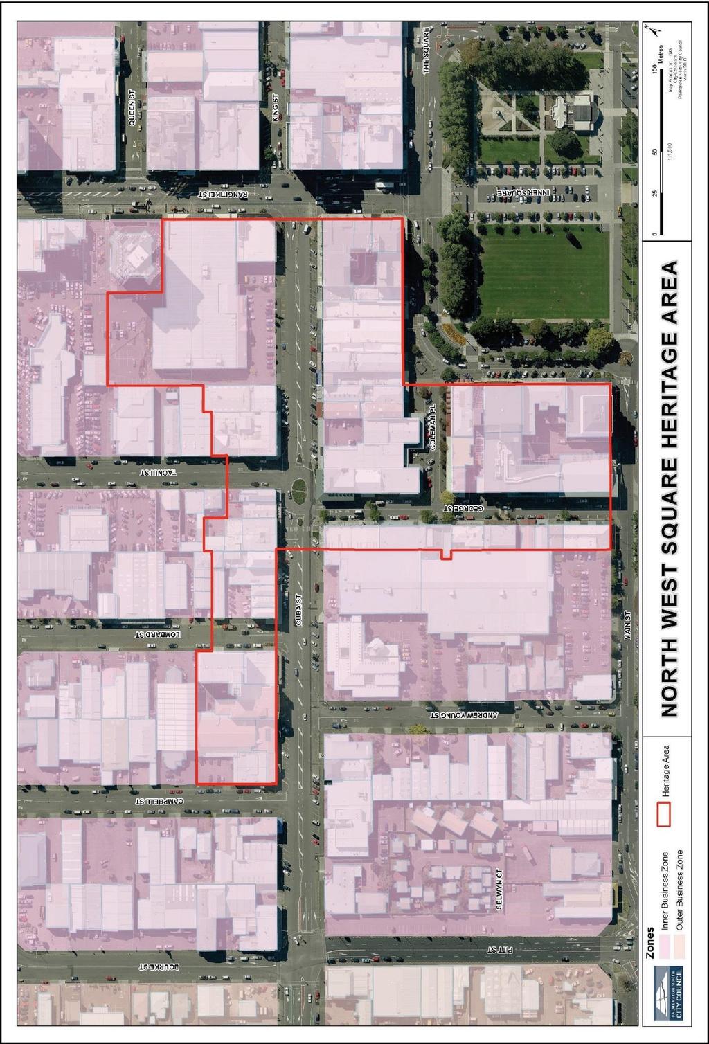
40 411
41 412
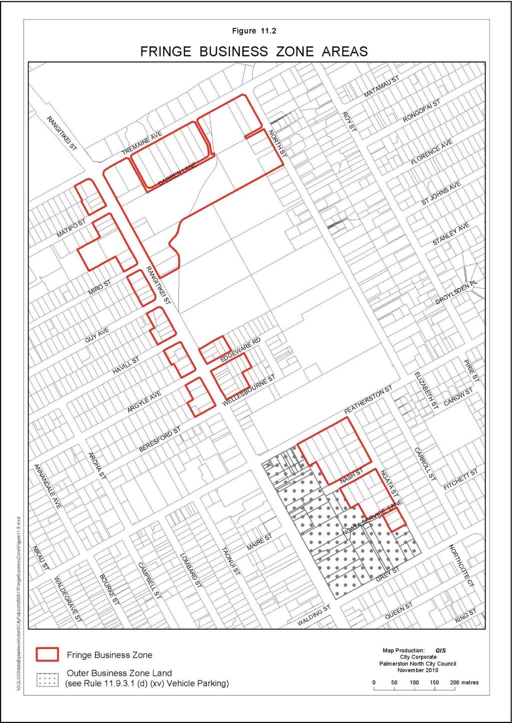
42 413
43 414
44 415
45 Local Business Zone Introduction The Local Business Zone has a primary purpose of catering to the day-to-day shopping and service needs of its surrounding residential communities. Currently the Local Business Zone covers the Ashhurst business centre and the local business centres dispersed throughout the City s suburban areas; these include shopping centre developments through to local stores. Some of these centres are the result of historical development (e.g. Terrace End), while others have developed more recently to accommodate newer residential areas such as Riverdale, Westbrook and Milson, with the most recent developments being at Aokautere/Summerhill and Kelvin Grove. The size of the catchment of surrounding residential communities and how they are to be serviced by Local Centres are a driving force behind the intention for the zone. Local catchments are determined in most cases by the amount of households surrounding a local centre radiating out from the centre itself. Supermarket developments can be part of the Local Business Zone and it is recognised that in these instances the local catchment serviced is wider than in a local centre where a supermarket is not present. Future development in the Local Business Zone will consist of the redevelopment or extension of existing centres and sites and also new Greenfield development, in particular in the areas set aside for future residential growth. Existing centres have been restricted in terms of their physical area and the size of business activity. This was done in order to ensure that the scale of business activity reflected the local status of the centre and that established residential neighbourhoods were protected from the further encroachment of central business activities. Council considers that this approach to local business area management remains valid and that it should be continued. The new approach of the zone is to enable change of use within existing local business facilities to ensure that these centres can be more responsive to changing needs or demands and ensure uptake is high within the zone. The City s local business areas have established themselves relative to the size of the surrounding suburban catchment they serve and their location within the catchment. Over time four categories of neighbourhood centre have emerged: Large Neighbourhood Centres, Small Neighbourhood Centres, Local Stores, and Variant Business Centres. To minimise adverse effects arising within the zone, and of local business activities on surrounding uses, performance standards will be maintained and have been further developed to safeguard residential areas from the potential impacts of business activities and/or associated development. New controls have been introduced to ensure good design outcomes are achieved within the Local Business Zone and the amenity and character of the areas they sit within are protected.
46 OBJECTIVES AND POLICIES Within the broad framework of the City View objectives in section 2, the following specific objectives and policies were identified for the Local Business Zone: OBJECTIVE 1 To enable the efficient use and continued vitality of the Local Business Zone by promoting activity that provides for the day-to-day shopping and service needs of local suburban catchments and the provision of attractive public open space. POLICIES 1.1 To recognise and provide for the different types of Local Business Zone areas as follows: Large Neighbourhood Centres, Small Neighbourhood Centres, Local Stores, Variant Business Centres. 1.2 To enable the on-going function of local business activities that are both convenient and provide a community focus for local residents. 1.3 To ensure that the activities which locate in the Local Business Zone reinforce the existing characteristics of the zone which include: Activities that service and meet the day-to-day needs of local suburban catchments. Activities that are conveniently located and have good connections to surrounding communities. Activities which do not detract from the function of the Inner, Outer and Fringe Business Zones. A diverse range of activities within local centres. 1.4 To promote a high quality pedestrian-orientated but vehicle accessible environment that maintains the compactness, convenience and vibrancy of the Local Business Zones. 1.5 To achieve a comprehensively planned and coordinated system of connections and other public open spaces that provide for safe and convenient access by a range of modes. 1.6 To ensure that public spaces (including privately owned spaces that are categorised by patterns of public use) are safe and attractive. 1.7 To require that any residential activity within the Local Business Zone be above ground floor level. 1.8 To promote the ability to change the use of buildings by ensuring regular entry points are provided at the street edge and the provision of ground level stud heights that are sufficient to allow for retrofitting for other uses. 1.9 To require as a key aspect of maintaining the continued vitality and economic viability of the Local Business Zone well designed public spaces and buildings which are: Fit for purpose Comfortable Safe Attractive Accessible
47 Durable To ensure a mix of small scale activities are provided in conjunction with developments that include a large scale anchor tenant activity. 418 The Local Business Zone contains four clear categories of use depending on the size of the surrounding suburban catchment they serve. These categories are Large Neighbourhood Centres, Small Neighbourhood Centres, Local Stores, and Variant Business Centres. With the exception of the Large Neighbourhood Centres, Local Business sites are generally quite limited in their area. Most offer a small range of retail services which provide convenient facilities for local residents. In some cases centres are often complemented by a range of other non-retail activities including small repair services or community facilities such as libraries. The zone offers local employment opportunities, in locations that can help to reduce work related journeys as employees may also live locally, and can encourage the continued use of the often already developed land and building resources. This encouragement to the on-going use of buildings in these zones can help to sustain variety within centres in the Local Business Zone, thereby avoiding some journeys to use shops and other facilities in the City centre. In the case of Ashhurst, the Large Neighbourhood Centre effectively forms the heart of the community which is enhanced by integration with a range of community facilities such as the Village Valley Centre. The centre is also quite diverse in nature and includes a number of small businesses providing important employment opportunities and convenient services for local residents. Variant Business Centres represent activities in the city that have established in historical locations and do not fit neatly within any of the City s business zones. As a result these centres, whilst not servicing a local catchment or playing a convenience retail role, have been absorbed by the Local Business Zone through specific provision for Variant Business Centres. These centres are scattered around the city and do not follow a pattern in their distribution. Such centres include activities that predominantly locate along major arterial roads and are vehicle orientated activities including, but not limited to, service stations, car sales yards and motels. To date the City has been fortunate to have maintained a strong network of local shopping areas. It is Council s intention that the on-going role of these areas be reinforced and enhanced by widening the range of opportunities available. The Local Business Zone is also often the economic, social and cultural focus of the local neighbourhood, and is important from that perspective. There are linkages between the perceived quality of the environment at a centre, its attractiveness and its commercial success. For that reason, all buildings in the Local Business Zones should contribute to a high quality public environment. OBJECTIVE 2 Neighbourhood centres in greenfield areas and on redeveloped sites are developed through a process of comprehensive planning, are conveniently located and accessible to the local community and exhibit high amenity values. POLICIES 2.1 To locate and distribute activities of the appropriate type, scale and mix within Greenfield developments to optimise the likelihood of commercial success and vibrancy, and ensure all residents have access to local service activities within a reasonable walking distance. 2.2 To achieve planned and coordinated development through a process of comprehensive planning of new neighbourhood centres in Greenfield and redeveloped sites. 2.3 To ensure neighbourhood centres on Greenfield and redeveloped sites provide a community focal point, and a high level of convenience and amenity. 2.4 To require large scale activities to be complemented by the provision of a range of activities in small scale tenancies. The appropriate range and scale of activities in any large (or small) neighbourhood centre depends on the area served. Where a centre is provided, its size and location will depend on the wider context availability of existing facilities and
48 419 connections to these, as well as the population served. Any large (or small) neighbourhood centre needs to be located where the activities intended are most likely to be successful. This is moderated by the requirement that the centre must also be at the centre of the neighbourhood it serves. Some parts of a greenfield growth area may be already served by existing adjacent facilities, however all areas should be provided with local services within reasonable walking distance. Greenfield development and site redevelopment offers the potential for coordinated and comprehensive planning. This ensures the street and public open space network, form and orientation of buildings are considered together to achieve the best results in each context. For example, comprehensive planning of car parking, both street-side and onsite, can lead to optimal convenience, efficiency and utilisation of parking which will help to keep the centre compact and avoid over-provision. OBJECTIVE 3 To enable a wide range of business and community activities within the Local Business Zone while avoiding adverse effects. POLICIES 3.1 To provide for a diverse range of activities within the Local Business Zone subject to meeting performance standards. 3.2 To provide for a wide range of activities that meet the economic and social needs of the local community while reinforcing the function of the Local Business Zone. 3.3 To discourage the establishment of activities which will have an adverse effect on the amenity values associated with the Local Business Zone. 3.4 To manage the adverse effects of business activities on each other or on other activities located within the Local Business Zone. 3.5 To ensure development provides a safe and convenient pedestrian and vehicular environment. Business activities have the potential to generate effects relating to such matters as noise; parking; location of access/egress points; and loading and storage areas which may impact on the level of amenity enjoyed by activities located within the business zone. To rectify this, appropriate safeguards have been introduced to ensure that any adverse effects are mitigated. Over time, a number of small business areas have developed their own particular character which contributes to people s appreciation and enjoyment of them. It is important to maintain and enhance how this character contributes to surrounding environments so that such environments can be enjoyed by future generations that choose to locate within them. To counteract the potential erosion of amenity that might arise as a consequence of allowing a relatively unrestricted range of activities to establish in the business zone, activities which are offensive or large in nature will be restricted. OBJECTIVE 4 The amenity values of neighbouring residential and recreation areas are protected. POLICIES 4.1 To avoid, remedy or mitigate the adverse environmental effects which may arise from activities within the Local Business Zone on the amenity values of activities at the interface with the zone. 4.2 To minimise the effects of building development or redevelopment on residential areas by avoiding: Excessive building scale
49 Overshadowing Inappropriate building bulk Invasion of privacy Loss of access to daylight. 4.3 To manage the adverse environmental effects of business activities on the following attributes of residential amenity: Visual amenity, including human scale and visual interest. Streetscape quality Acoustic environment Pedestrian and cyclist safety Vehicular access and safety. 4.4 To promote sensitive landscape or architectural design at the interface with adjoining residential areas to manage any adverse visual effects of development. 420 The existing Local Business Zones are in most cases located in the heart of residential areas, where they provide important and convenient local services and facilities. However, there is the potential for activities in the Local Business Zone to cause adverse effects on the surrounding area. It is important that these effects are addressed and as far as possible avoided. The most likely place at which these effects arise is at the residential interfaces where the two quite different activities come into closest contact. Therefore it is at the interface that the greatest care must be taken. While in existing Local Business Zones it is usually only possible to ameliorate the effects on the Residential area, where a new zone, or Greenfield area is established care can be taken to ensure that the two activity areas are made as compatible as possible at the outset. OBJECTIVE 5 The Local Business Zone has a high level of visual amenity, safety and comfort. POLICIES 5.1 To require high quality building design within the Local Business Zone that acknowledges and responds to the context of the site and surrounding environment, and contributes positively to the image of the neighbourhood and quality of experience of adjacent streets and other public open spaces. 5.2 To mitigate the visual effects of large areas of asphalt by ensuring car parking is visually attractive when viewed from both the public and private realms. 5.3 To ensure the visual effects of development are managed by requiring skilled landscaping and urban design to contribute to the quality and attractiveness of the wider public environment. 5.4 To require all development to provide active frontages, including entrances and openings, that face any street. 5.5 To avoid blank secondary frontages and service areas at the street edge. 5.6 To enhance the visual quality and design of ground floor level developments fronting streets, public space and pedestrian thoroughfares, in particular to require, depending on type of Local Business Zone, all buildings to be characterised by active and fine-grained street edge treatments.
50 421 Each Local Business Zone area contributes to the sense of place of the local neighbourhood around it and, if identified as a centre, can substantially define the identity of the neighbourhood. Good quality environments, including a good mix of activities, attract people and encourage them to stay. Conversely, utilitarian centres tend to be used only for essential activity, and where people have no option. The visual amenity of buildings and the spaces around and between buildings contributes to their attractiveness and functional amenity. At the immediate local level, large blank walls can be both monotonous and visually overwhelming, compromising neighbouring residential properties and the adjacent street. The maximum frontage width reflects the existing fine grained frontage and lot widths within the Local Business Zones. Furthermore active frontages at street edges are positively linked with increased occupation and use. As inactive frontages lack visual appeal and create an uninviting environment for pedestrians at the street edge, wider frontages are subject to a higher level of scrutiny. The existing fined-grained nature of development is a critical component that contributes to the quality and attractiveness of the wider street environment RULES: PERMITTED ACTIVITIES R Permitted Activities Any activity is a Permitted Activity except for: Those specified as Controlled Activities, Restricted Discretionary Activities or Discretionary Activities Offensive Activities, Industrial Activities, Crematoria and Residential Accommodation at Ground Floor Level which are Non-Complying Activities Provided that the following Performance Standards are complied with: Performance Standards (a) (b) (c) (d) (e) (f) Lighting i. Compliance with R (a)(i)(ii),(iv),(v) and (vi) Screening Car park lighting may be turned off no earlier than 30 minutes after the last activity served by the car park ceases. i. A solid close-boarded fence or wall of not less than 1.8 m in height shall be erected on any boundary that adjoins a residential or recreational zone site; Signs Any area used for the outdoor storage of products, goods, materials or waste shall be screened along any boundary fronting or adjoining a residential or recreation zone property or the road by a close-boarded fence or wall of not less than 1.8 m in height; this shall also be applied to gating across a vehicle access point. Compliance with R Hazardous Facilities Compliance with the provisions of Section 14 Hazardous Substances. Size of Function No single business activity within an existing building shall exceed 300m 2 gross floor area. Residential Accommodation (excluding additions and alterations to existing dwellings). i. No residential accommodation shall be located at the ground floor level. i Residential accommodation shall not be the dominant activity on the site. Non-habitable accessory buildings that are ancillary to residential accommodation are permitted at
51 422 the rear of the building and shall not exceed 10m2. A specific performance standard for residential accommodation has been included to allow for the mixed use of land zoned Local Business within the City. The intention of the performance condition is to recognise the need to provide for on-site accommodation at a scale which will not compromise the primary intent of the Local Business Zone to provide a convenient service to, or employment for, the surrounding community. Residential accommodation above the ground floor level also contributes a sense of visual presence and scale to a centre, natural surveillance and visual interest after dark whilst remaining in keeping with the surrounding residential areas. (g) (h) (i) (j) Hours of Operation for Activities Involved in the Sale of Alcohol Any activity involving the sale of alcohol for consumption on or off the premises shall comply with the following maximum hours of operation: Sunday -Thursday Friday and Saturday Parking, Loading and Access 7:00 am to 11:30 pm 7:00 am to 1:30 am the following morning Compliance with Rules the following performance standards of R : (b)(i) Parking Spaces for People with Disabilities; (b)(ii) Parking Provision for the Outer all Zones except for the Inner Business Zone (c) Car Park Landscape Design; (d) Formation of Parking Spaces; (e) and (f) Loading Space Standards Provision and Design; (a) Vehicle Access Standards. Servicing and Loading Hours Compliance with R (g). Noise Compliance with R The intention of the Local Business Zone is to create a situation where a wide variety of activities can establish and provide a convenient service to, or employment for, the surrounding community. There will however be some effects which arise as the result of these activities which could have significant negative impacts on adjoining residential areas. The rules detailed above are intended to control those adverse effects, e.g. the objectionable overspill of light, while leaving sufficient flexibility to encourage a wide range of activities. The limited area of most Local Business Zones and the necessity for them to still provide convenient local retailing means that it is important that one area is not taken up by a single activity. This has resulted in Council introducing a control over the amount of the area a single activity may take up in the Local Business Zone. NOTE TO PLAN USER Also refer to: R23.7.1(i) Radiofrequency Field Exposure. R Restricted Discretionary Activities Drive Through Facilities.
52 R The Construction, Alteration of, or Addition to Buildings The construction, alteration of, or addition to buildings and structures is a Permitted Activity except for: Those specified as Restricted Discretionary Activities, Discretionary Activities or Non Complying. Provided that the following Performance Standards are complied with: Performance Standards (a) Maximum Floor Area i. The construction of all buildings with a maximum total gross floor area of 50m 2 are permitted. In respect of existing buildings, the permitted size of any external alteration or addition is no more than 50m 2 or 20% of the existing gross floor area, whichever is smaller. 423 (b) (c) (d) (e) It is not inherently problematic for buildings to be constructed over this size and they are not to be discouraged. The intention of this rule is to act as a trigger to apply discretionary provisions to a development that exceeds this size. It is anticipated that as the size of a building increases, the potential effects increase, therefore this trigger gives Council the opportunity to apply a higher level of scrutiny and assessment criteria on these developments to ensure good outcomes are achieved that suit the environment they locate within. It also helps to ensure that a diverse range of activities is achieved in the Local Business Zone while avoiding a large activity crowding out a locally focused mix of activities. Building Height i. Any building or structure or part of a building or structure, built on any part of a site which adjoins a residential zone site, must comply with the residential height recession plane contained in R (a). i All other structures must not exceed 9 m in height. Subject to (ii) above, all structures shall comply with the requirements of R Ground Floor Height The permitted ground floor height of any building is to be not less than 1.3 times the floor to floor height of upper floors, and is to extend the full width of the frontage and back a distance of not less than 12 metres, or the depth of the building, whichever is the lesser. Separation Distances i. Any building on a site which adjoins any part of a residential or recreational zone site will be located at least 3 metres from the common boundary. Any building built to the frontage of a Local Business Zone site is also permitted to be built up to the side boundary adjoining a residential zone site for a distance of up to 15 metres back from the frontage. Building Frontages i. Maximum Width: The permitted maximum width of any ground floor level tenancy shall not exceed 7 metres. Positioning: a. Within areas identified as Large Neighbourhood Centres, all buildings are to be built to the front boundary of a site along no less than 50% of the street boundary. b. Within those areas identified as Small Neighbourhood Centres and Local Stores all buildings shall be built entirely to the front boundary. c. Within those areas identified as Variant Business Centres, there is no requirement to build
53 424 (f) (g) Verandas to the front boundary. d. All buildings required to be built to the front boundary shall provide at least one pedestrian entrance at the street. i. Within Large Neighbourhood Centres, Small Neighbourhood Centres and Local Stores, verandas will be constructed along the full length of any building frontage facing a street whether the building is built to the street edge or setback from it and will be connected to any adjoining verandas. i Verandas will be setback 600mm from the face of the kerb of any road carriageway or car parking area. Within Variant Business Centres, a veranda is not required along the length of the building frontage, a cover over all main pedestrian entrances will be provided that covers the width of the entrance opening for a depth not less than 2 metres. Shop fronts and Glazing i. Large Neighbourhood Centres, Small Neighbourhood Centres and Local Stores All buildings shall have clear glazing for 75% of the height of the ground floor frontage and for no less than 75% of the ground floor frontage width. Maximum length of a blank wall along a frontage shall be no greater than 3 metres. No roller shutters are permitted along a retail frontage at any time. Variant Business Centres Maximum allowed width of a shop front is 15 metres. All tenancies shall have clear glazing for 75% of the height of the ground floor frontage and for no less than 50% of the ground floor frontage width. Maximum length of a blank wall along a frontage shall be no greater than 6 metres. NOTE TO PLAN USERS The rules contained within R (e)(ii),(f ) and (g) that relate to Variant Business Centres are subject to the limitations identified within the definition for Variant Business Centre in Section 4, Definitions. (h) (i) Parking, Loading and Access Compliance with R (h). Ground Level Parking Compliance with R (h). Buildings in the Local Business Zone are usually quite different in size and style to those in the surrounding, mainly residential area. It is important therefore, that at the residential interface the size and general bulk of buildings is constrained to make them compatible with the adjoining dwellings. This also ensures there are minimal effects on overall amenity values. Where dwellings are built within the Zone it is important that they enjoy a good amenity standard to ensure they still represent a reasonable living environment. (j) Landscape Amenity Compliance with R (i) with the following exceptions: a. Street Frontage Any building that is not built to the street frontage must provide at least one specimen
54 tree for every 7 metres of site frontage, and a 2 metre deep planting strip for any length of un-built frontage greater than 5 metres. b. Perimeter Planting An amenity strip of not less than 1.5 metres shall be provided along the boundary of any site which shares a common boundary with a residentially zoned site except where a building is allowed up to an adjoining boundary under R (d). For the purposes of interpreting R (j), with regard to the bullet point under (a) above is to replace the first two bullet points under R (i)(i) Street Frontage. With regard to the bullet point under (b) above, this is to replace the first bullet point under R (i)(v) Perimeter Planting. All other provisions under R (i) are to be applied as written with no exceptions. Landscaping is an important contributor to the provision and maintenance of adequate amenity at the interface between the Local Business Zone and neighbouring residential, recreational, or conservation and amenity areas. In addition to its amenity contribution, landscaping also provides a useful technique for mitigating adverse effects through, for example, softening the appearance of development (e.g. monotonous building form, parking areas); separating activities; and providing form, scale and texture that complement development. NOTE TO PLAN USERS 425 In relation to frontage planting the performance conditions can be met by: the planting of trees at a frequency of one per seven metres along the site frontage; or alternatively group planting the required number of trees at some point(s) along the frontage RULES: RESTRICTED DISCRETIONARY ACTIVITIES R Activities which do not Comply with the Permitted Activity Performance Standards Activities which do not comply with the Permitted Performance Standards (in Rule ) in relation to: (a) Lighting (b) Screening (c) Size of Function (d) Residential Accommodation (e) Vehicle Parking (f) Loading and Access (g) Car Park Landscape Design (h) Servicing and Loading Hours. are Restricted Discretionary Activities with regard to: Effects on residential amenity Affects on viability and choice of Local Business activities Public Safety Visual amenity Internal amenity Street edge amenity The safe and efficient operation of the roading network The provision of car parking Efficient, convenient and safe access.
55 Determination Clause In determining whether to grant consent and what conditions to impose, if any, Council will, in addition to the City View Objectives in Section 2, and the overarching Business Zone and Local Business Zone objectives and policies, assess any application in terms of the assessment criteria below. Also, where a proposal fails to comply with R (e), Size of function, then as well as assessing the non-compliance against R (c), the Council will also assess any application under the remaining relevant assessment criteria in R (a),(b) and (e)-(h). Where a proposal fails to comply with one of R (a)-(d) and (f)-(j), only the assessment criteria triggered by the specific non-compliance will be assessed. Assessment Criteria (a) (b) Lighting The assessment criteria contained in R (a) Screening The assessment criteria contained in R (b) And i. The extent to which outdoor storage areas are sited and designed so that the visual amenity and the quality of streetscape is maintained. The extent to which outdoor storage areas are sited and designed to allow for the unfettered operation of access, parking, loading and manoeuvring areas for vehicles. 426 The Local Business Zone shares an extensive interface with the Residential Zone. Because the range of activities and the form of development within the Local Business Zone is so diverse, variations to the way outdoor storage areas are provided may be considered. However, it is critical that the visual amenity and the quality of streetscape in nearby residential areas is maintained. (c) (d) Size of Function i. The extent to which a range of convenient services are provided to the surrounding local catchment. i The extent to which a large scale anchor tenant and a mix of smaller scale activities provide a diverse range of goods and services to the local catchment. The extent to which crowding out of small scale activities by a dominant large scale activity is avoided. Ensuring that a range of activities have the opportunity to locate within a Local Business centre reinforces the overall intention of the Local Business Zone which is to provide a variety of activities in convenient locations that meet the day-to-day needs of local suburban catchments. Residential Accommodation i. The extent to which the presence of residential accommodation contributes to the scale and visual presence of a centre. i iv. The extent to which the development provides for a mix of activity that supports the purpose of the Local Business Zone and provides services to the local residential catchments. The extent to which residential activity does not lead to the inefficient use and development of physical resources of the Local Business Zone. The extent to which residential occupation maintains appropriate continuity of publicly relevant activity at the street edge at ground level.
56 427 A mix of activities in the Local Business Zone includes supermarkets where the opportunity exists, residential accommodation and local service shops and offices. Residential Accommodation at an above ground level is seen as a positive addition to a Local Business centre as it contributes to residential choice and provides a sense of visual presence and scale to that centre and also natural surveillance and visual interest after dark. By requiring residential accommodation to be ancillary to the core Local Business activity this ensures that the overall intention of the zone is protected and the displacement of Local Business services does not occur. (e) (f) (g) (h) Vehicle Parking The assessment criteria contained in R (d), excluding assessment criterion R (d)(xv). Loading and Access The assessment criteria contained in R (c), excluding assessment criterion R (c)(iv). Car Park Landscape Design The assessment criteria contained in R (e). Servicing and Loading Hours The assessment criteria contained in R (f ). R The Construction, External Alteration of, or Addition to a Building which does not comply with the Performance Conditions for Permitted Activities The construction, external alteration or addition to a building which does not comply with the Performance Standards for Permitted Activities (in R ) in relation to: (a) Maximum floor area, maximum building height (b) Ground floor height (c) Height of any building which adjoins a site in a residential zone and separation distance (d) Building frontages, shop fronts and glazing (e) Pedestrian cover and verandas (f) Vehicle parking (g) Loading and access (h) Car park landscape design (i) Ground level parking (j) Landscape amenity. are Restricted Discretionary Activities with regard to: External design and appearance Building mass and height Site layout Relation to streets and other public spaces Effects on residential amenity Scale relation to existing smaller neighbours Pedestrian cover Parking areas
57 The safe and efficient operation of the road network Safety and security Landscape amenity. Performance Standards All activities under R that involve the re-development of 50% or greater of the total area of a Local Business site, or any development on a greenfield site, must provide (as part of the resource consent application) a comprehensive development plan with regard to the design, layout and servicing of the Local Business Zone site. The Comprehensive Development Plan must consider and address, where relevant, the following issues: i. Intensity and concentration of activity at the Local Business centre; i iv. Provision for a mix of activities, including residential and/or offices above ground, and good local services/amenities; Large format tenancies integrated, placed and orientated to support smaller tenancies; Planning that anticipates staged development and/or future growth, including how the development relates to neighbouring sites and areas; v. Provision of suitably scaled, high quality sunny and active open space at the centre; vi. v vi ix. Multiple high quality connections to the surrounding street network, including the finest grain of pedestrian connections between spaces and relation to the public space system in the wider neighbourhood; Formation of positively defined, shaped, high quality open spaces; Provision for informal surveillance over all publicly accessible open spaces; Development of a distinctive, memorable and context-appropriate sense of place; x. Extent and quality of hard and soft landscaping, including their consistency with the wider landscape network; xi. x xi xiv. Convenient, efficient and coordinated car parking; Building bulk and form that: a. is coordinated and coherent, b. contributes to a positive image for the centre, and c. defines adjacent open spaces. 428 Ensuring safe, efficient operation of the roading network, both within and around the centre; Pedestrian safety and amenity within the centre. The total area of a Local Business centre is the full extent of the land zoned for Local Business in each locality, and that is collectively regarded as a centre. Buildings and activities consented under the CDP approach may be quite different in scale and size to those provided for under the permitted activity rules. This outcome is anticipated by the plan and the effects of such activities are assessed and managed through the preparation of a CDP and the resource consent process. The above is not a prescriptive list of requirements, but an indication of the range of matters that may be relevant. Relevance will depend on site characteristics including the context of streets, connections and adjoining activity, and the scale and type of development to be covered by the CDP. These issues will be considered to the extent that they are relevant in each situation. The degree of emphasis given to each will depend on specific context, with the intention of achieving a well-planned, coordinated outcome that satisfies the LBZ Objectives.
58 The extent of documentation required will be that necessary to describe the planning and design intention and demonstrate that the relevant issues are addressed by the CDP. That will vary from project to project depending on the type of centre, prominence of the site and the size of the area covered. It might include, but will not necessarily be limited to: Context plan, describing the development in the context of neighbouring sites and areas and showing activity, building form and location, streets and street landscaping. Site and context analysis which identifies important existing conditions. Site plan showing the general arrangement of buildings, activities, open spaces including streets, parking, servicing and movement. Description of the intended building form envelopes, potentially with description of shading effects on any notable public open spaces should these be provided. Indication of the intended activities and their location, and the location and type of visual and physical connections between buildings and public open spaces including streets. Design rationale, which provides the reasoning for the intended approach and describes how the relevant issues identified have been responded to. There is no one optimal way of scoping or presenting the information for a CDP. The amount of information and type of approach will relate to the size and complexity of the project. Confirmation of relevant issues and precise information requirements should be discussed with the PNCC consents team early in the CDP formulation process. Determination Clause In determining whether to grant consent and what conditions to impose, if any, the Council will, in addition to the City View Objectives in Section 2 and the overarching Business Zone and Local Business Zone objectives and policies, assess any application in terms of the assessment criteria below. Also, where a proposal fails to comply with R (a), Maximum Floor Area and R (b) Building Height, then as well as assessing the non-compliance against R (a), the Council will also assess any application under the remaining relevant assessment criteria in R (b) - (j). Where a proposal falls under R (b)-(j), only the assessment criteria triggered by the specific non-compliance will be assessed. Assessment Criteria (a) Maximum Floor Area and Maximum Building Height The assessment criteria contained in R (c), And i. The extent to which the building relates to the character of its setting, contributes to the quality of adjoining open spaces, and avoids visual dominance. i The extent to which new large buildings retain reasonable visual privacy and daylighting for adjacent residential accommodation. The extent to which plant and services (e.g. air conditioning and rubbish storage) and their enclosure is integrated into the building design, screened from public view or otherwise treated to enhance the appearance of the building. Scale in relation to smaller neighbours iv. The extent to which large buildings are complemented by small scale and narrow frontages to achieve diversity and contribute to a fine-grained, active street edge where this is appropriate. v. The extent to which large buildings integrate forms, dimensions and/or alignments which establish a positive scale relationship with smaller neighbours. Pedestrian Linkages vi. 429 The extent to which direct and safe public through-site pedestrian links are provided on large blocks, where these provide a useful link between known or potential destinations.
59 430 Developments that are prominent due to their conspicuously large size or height have the potential to create commensurately large effects. While these developments are important for the economic viability and vitality of the City, it is equally important that they contribute to the environmental quality of the City s urban area. In all cases, the Council expects buildings to face the street edge and to positively contribute to the visual character and amenity of the surrounding area. Design techniques to avoid buildings visually dominating their surroundings may include breaking down the scale elements of the façade with modulation of form and variation of surface treatment. Risk to light and amenity can occur with intensive development. The amenity of residential activity becomes increasingly important. This includes consideration of daylight access to dwellings, overlooking, privacy and outlook, all of which are impacted by the mass and height of buildings. Regardless of their height, the roofs of large floor plate buildings can have significant visual impacts especially when seen from elevated sites around the City. Modulation techniques may include visual subdivision of large roof planes; sculptural roof forms; and expression of structure or secondary form, such as service rooms and towers. With good planning and design, large buildings do not need to compromise their setting, and can instead be an asset to their neighbourhood. (b) (c) (d) Ground Floor Height i. The extent to which the ground floor height provides suitable clearance for both intended and possible future functions within that building. The extent to which the ground floor height relates to the height of adjacent buildings. Height of any Building which Adjoins a Site in a Residential Zone and Separation Distance The assessment criteria contained in R (b). Building Frontages, Shopfronts and Glazing i. The extent to which the potential adverse effects of blank walls adjoining residential sites, at the street edge and/or conspicuously large high-level blank walls that are in prominent view from streets and other public spaces are avoided or screened. i iv. The extent to which visual and physical connections are maintained between building interiors and adjoining streets and other public spaces to a degree appropriate to the location. The extent to which a ground floor frontage that is wider than those in close proximity to it provides a visual interest and an active edge including multiple entries. The extent to which large scale developments in Large and Small Neighbourhood Centres and also Local Stores are complemented by small scale and narrow frontages to achieve diversity and contribute to a fine-grained active street edge. v. The effects of not building to the street frontage on the pattern of adjacent activities and the continuity of the street frontage. vi. v vi ix. Whether the building setback from the street frontage creates positive open spaces with a high usability and aesthetic quality, and which contribute positively to the public space system of the city. The extent to which a setback of the building entrance avoids creating spaces which might provide for concealment. The extent to which eliminating the setback will lead to enhanced visual and acoustic privacy for residents. For variant business and or vehicle orientated activities, the extent to which the surrounding environment is characterised by patterns of stand-alone buildings that are set back from the street edge. x. The extent to which any building set back from a street edge enhances the appearance of the site from the road and defines the street boundary with high quality landscaping.
60 431 xi. For variant business and or vehicle orientated activities where buildings are set back from the street edge, the extent to which pedestrian only or pedestrian priority areas are provided with kerbs or raised pedestrian facilities or material differentiation. The Council wishes to ensure that new building development or redevelopment relates positively to the street edge and creates an attractive interface where the public and private realms meet. In particular, development should maintain visual and physical connections to the street by providing frontages that include entrances and openings facing the edge of streets. The Council requires development to articulate or eliminate wall surfaces that are featureless or blank. Large blank surfaces should not occur at ground level at the street edge as these lack interest and activity, compromising the experience of the adjacent space. A flat wall surface might constitute a small proportion of ground floor facades, but only if the quality of the street edge is not compromised as a result. While a building may have primary frontage, other visible facades should include detail and openings and be treated similarly as frontages albeit secondary ones. Development needs to be provided for in a way that offers flexibility and recognises the operating characteristics of large format and vehicle orientated activities while ensuring a high level of visual amenity is achieved. The requirement to build to the front boundary for sites recognises the importance of maintaining the existing street edge alignment. Departure from this core principle is a matter of discretion. (e) (f) (g) (h) (i) (j) Pedestrian Cover and Verandas The assessment criteria contained in R (e), And i. The extent to which the veranda is integrated with the design of the building and maintains continuity of shelter with adjoining sites. The effects of not providing a veranda upon the use, design and appearance of adjoining buildings. Shelter for pedestrians is an important amenity consideration. It is important to provide the shelter necessary at the building entrance for pedestrians, however this is not necessary along the sides of buildings, or for buildings set well back from the street frontage. Cover at the building entrance is important for way finding and legibility because it signals the location of the entrance to the building. Vehicle Parking The assessment criteria contained in R (d). Loading and Access The assessment criteria in R (c). Car Park Landscaping The assessment criteria contained in R (e). Ground Level Parking The assessment criteria contained in R (f ). Landscape Amenity i. The extent to which on-site landscaping complements public landscaping at or near the street edge and establishes conditions of safety, visual interest and amenity within the development. i The extent to which alternative provision of on-site amenity and landscaping maintains and enhances the amenity of the wider streetscape and residential areas. The extent to which growing conditions are provided for that will ensure the successful establishment, growth and on-going viability of planting. The specified approach to landscaping provision will not be practical in every instance. However, it is critical that
61 alternative responses to landscaping provision positively contribute to on-site and wider streetscape amenity. The maintenance of landscaping, especially in the first twelve months, is critical to its actual success. Factors such as irrigation, wind protection and the growing medium are all critical to the successful establishment of landscaping DISCRETIONARY ACTIVITIES R Discretionary Activities Any activity or the construction, reconstruction or alteration of any building or structure which is not provided for by R , R , R , R , R or R is a Discretionary Activity. R Service Stations Any new Service Station or addition or alteration to an existing Service Station is a Discretionary Activity. NOTE TO PLAN USERS 432 Replacement of like for like is not an addition or alteration and is a permitted activity RULES: NON-COMPLYING ACTIVITIES R Offensive Activities, Industrial Activities and Crematoria Offensive Activities, Industrial Activities and Crematoria are Non-Complying Activities. Offensive Activities and Crematoria have a range of potential effects that could adversely affect the amenity qualities of the Local Business Zone. The application of Non-Complying Activity status to these activities will ensure that any Offensive Activity or Crematoria has to demonstrate that it can satisfy the requirements of Sections 104 and 104D of the Resource Management Act 1991 prior to any approval being granted RULES: NOTIFICATION R Notification i. The following activity addressed in this section must not be publicly notified: R and R The following activity addressed in this section must not be limited notified: R and R RULES : NOISE R Noise (a) Noise i. Noise from any activity within the Local Business Zone must not exceed the following limits at any point within any other site within the Local Business Zone: At any time 60 db L Aeq(15mins) Daily 10:00pm to 7:00am the following day 80 dba L max Noise from any activity must not exceed the following limits at any point within any site zoned for residential purposes: 7:00am to 7:00pm 55 db L Aeq(15mins) 7:00pm to 10:00pm 10:00pm to 7:00am 50 db L Aeq(15mins) 45 db L Aeq(15mins)
62 433 10:00pm to 7:00am (Nighttime L max ) 75 dba L max i Where it is impracticable to measure outside a building, the noise from any activity within the Local Business Zone must not exceed the following limits, inside any residential units in any building on any other site within the Local Business Zone: Bedrooms 10:00pm to 7:00am the following day 35 db L Aeq(15mins) Bedrooms 10:00pm to 7:00am the following day Other habitable rooms 55 dba L max 40 db L Aeq(15mins) This must not allow any relaxation in the noise limits in (i), and (ii) of R The noise rules within the Local Business Zone are designed to allow activities to make maximum noise while still providing a reasonable level of control to residential activities in the area. Where noise sensitive uses (including residential activities) are proposed for the Local Business Zone it is the responsibility of the designer, developer, owner and user to ensure that buildings are appropriately insulated against higher levels of noise that are allowed. Residents in the Local Business Zone must accept that some adverse noise impacts will be experienced from time to time. In this regard, it is important that residential development in the Local Business Zone does not compromise the effective development and operation of business activities. (b) (c) (d) (e) Noise Insulation Any habitable room in a building used by a noise sensitive activity within the Local Business Zone shall be protected from noise arising from outside the building by ensuring the external sound insulation level achieves the following minimum performance standard: Bedrooms and sleeping areas D nt,w + C tr > 25dB Compliance with this performance standard must be achieved by ensuring bedrooms and sleeping and habitable rooms are designed and constructed in a manner that accords with an acoustic design certificate signed by a suitably qualified acoustic engineer stating the design as proposed will achieve compliance with the above performance standard. Ventilation Compliance with R (c). Outdoor Speaker Noise Compliance with R (d). Fixed Plant Compliance with R (e).
63 11.11 Fringe Business Zone INTRODUCTION 434 The District Plan strategy for the City s business areas is underpinned by the overall objective to achieve the sustainable use and development of physical resources within the City s business areas. The strategy seeks to promote the efficient use and continued viability of existing physical resources through the existing hierarchy of established business zones within the City. A key component of achieving the Business Zones overarching objective is to ensure an integrated approach is taken to managing retail activity by maintaining clear distinctions between the City s hierarchy of business zones. As part of the integrated approach to managing retail activities within the City s business zones the Fringe Business Zone provides for large format retail activities but not on a scale that adversely affects the Inner Business Zone s function as the primary retailing precinct in Palmerston North. The Fringe Business Zone covers three distinct areas within Palmerston North City, which are located on or within the vicinity of the Primary Roading Network (see Figure 20A.2). The Zone is intended to provide for space extensive retail activities, commonly referred to as large format retailing as well as other activities that contribute towards the community s business needs. The Fringe Business Zone is a relatively new zone, initiated in 2004, to provide suitable land areas for the growing demand for large format retailing. This type of retailing by its nature requires relatively large areas of commercially zoned land for the large size of buildings it requires and associated parking areas. A study commissioned by the Council in 2003, named the Palmerston North Retail Study (May 2003) concluded that there was a shortage of land for this form of retailing activity and areas have therefore been zoned to provide for these activities. There are several critical aspects associated with the Fringe Business Zone covering both the immediate surrounding environment as well as the effects on other localities within the City. These critical aspects support the need for rules and performance standards which are specific to the zone. The first critical factor is that the Fringe Business Zone must be developed and operated in such a way that it does not adversely affect the efficient use and continued viability of existing physical resources within the Inner and Outer Business Zones. To ensure this, the Zone has controls that will result in it being complementary to the Inner and Outer Business Zones, furthering Palmerston North s reputation as a desirable destination retail location. The controls have the effect of only allowing larger format style activities. The second critical factor is that the zoned areas front onto roads forming part of the Primary Roading Network, as well as being located along one of the main entrance ways into Palmerston North. These zoned areas are therefore very much exposed to the public domain. Rangitikei Street is to be developed as a significant entrance to the city as part of the City Heart project. Tremaine Avenue and Featherston Street both contribute significantly towards the movement of traffic within Palmerston North and therefore have a high profile in terms of the number of persons travelling on these roads. The third critical factor is the environment surrounding the zoned areas fronts and/or adjoins land in the residential zones. Therefore due to the sensitive interface between the Fringe Business Zone areas and surrounding environment, controls have been placed in the District Plan to avoid, remedy or mitigate the visual effects on the residential environment, whilst enabling large format retailing activities to establish within Palmerston North in these sensitive areas.
64 OBJECTIVES AND POLICIES Within the broad framework of the City View objectives in Section 2, the following objectives and policies were identified for the Fringe Business Zone: OBJECTIVE 1 To provide for the establishment of large format retailing in appropriate locations. POLICIES 1.1 To ensure that there is sufficient and suitable land to meet the space extensive requirements of large format retailing activities. 1.2 To ensure that any areas zoned Fringe Business are located so that the role of the Inner Business Zone is reinforced. The Fringe Business Zone has been established in response to the increasing market presence of large format retailers and the lack of suitably zoned sites to meet both their present and future needs. While large format retailing activity is permitted also in the Inner and Outer Business Zones there is a lack of readily available suitable sites in these zones for this form of activity. The areas zoned Fringe Business are located on and in the vicinity of Rangitikei Street and in a number of cases have a residential interface, either by adjoining a residentially zoned property and/or facing a residentially zoned property(ies) separated by a road. All Fringe Business zoned areas adjoin Primary Roads (i.e. Major Arterial, Minor Arterial or Collector Roads), which provides them with exposure as well as easy access onto the roading network. While there are some advantages in enabling significant integrated large format developments, these can also create marketing opportunities strong enough to attract key retailers out of the Inner Business Zone and thereby reduce the efficient and effective use of this zone as a whole. The approach adopted with the Fringe Business Zone is to allow integrated development but not on a scale that adversely affects the Inner Business Zone s function as the primary retailing precinct in Palmerston North. OBJECTIVE 2 To ensure that the environmental effects of large format retailing are appropriately managed. POLICIES 2.1 To ensure that the establishment of retail activities in the Fringe Business Zone does not create any significant adverse distributional effects through undermining the vibrancy and viability of the CBD. 2.2 That the environmental effects on the surrounding environment, which may arise from activities in the Fringe Business Zone, are avoided, remedied or mitigated. 2.3 To allow transitional activities on the boundary with Ngata Street as an option to mitigate the visual effects of large format retailing on adjacent residential activities. 2.4 To ensure that development within the zone on sites fronting streets, particularly those listed as forming part of the Primary Roading Network, project an image of a quality consistent with their role as main entrances to the city. Activities in the Fringe Business Zone, due to their scale, have the potential to create adverse environmental effects. These environmental effects include distributional effects pursuant to the potential relocation of existing retail activities from the Inner and Outer Business Zones to the Fringe Business Zone. The efficient use and continued viability of the existing physical resources within the Inner and Outer Business Zones is an important resource
65 436 management consideration. Council s policy response is to ensure that smaller retail activities will be discouraged from establishing in the Fringe Business Zone. It has also been identified that activities in the Fringe Business Zone have the potential to create adverse environmental effects on the surrounding environment. This potential is through a combination of the nature of the surrounding environment and the large-scale nature of the types of activities which are provided for in the Fringe Business Zone. Activities within the Fringe Business Zone can typically be expected to generate high levels of traffic due to their destination type nature. This has the potential to create adverse environmental effects in terms of both parking overflow onto streets as well as affecting the safe and efficient operation of the roading network. Rangitikei Street provides a key role in that it provides a major route into the city and it is being upgraded as a significant entrance to the city as part of the City Heart City Centre revitalisation project. Development on adjoining sites will contribute to the overall visual outcomes that are anticipated to be achieved. The other significant effect on the surrounding environment is that the nature of large format retailing lends itself to the construction of extensive paved areas for car parking as well as relatively large building structures, typically with large blank side and rear walls. These have the potential to cause adverse visual effects on both the streetscape as well as on the nearby residential amenity. It is noted that the majority of the area surrounding the Tremaine Avenue Fringe Business Zoned area is Industrial in nature and consequentially there is a limited amount of residential amenity to be maintained compared to other Fringe Business Zoned areas. OBJECTIVE 3 To provide for appropriate activities, in addition to large format retailing, in the Fringe Business Zone which do not detract from the vibrancy and vitality of the CBD. POLICIES 3.1 To allow for identified activities that are compatible with the purpose of the Fringe Business Zone. 3.2 To ensure that activities in the Fringe Business Zone do not adversely affect the efficient use of existing physical resources in the CBD. 3.3 To recognise existing activities in the zone that contribute towards Palmerston North s wider commercial needs. 3.4 To ensure that activities, particularly those listed as forming part of the Primary Roading Network, project an image of a quality consistent with their role as main entrances to the city. As well as allowing for large format retailing activities in the Fringe Business Zone, it is also recognised that there are a number of activities existing within the areas that were rezoned and/or have no distributional effects on the core CBD of Palmerston North. A number of these activities contribute towards the wider retailing needs of Palmerston North such as trade suppliers and automotive and marine suppliers. A number of these activities were already in existence at the time that the identified areas were rezoned Fringe Business. Like large format retail activities, other activities also contribute towards the overall visual outcomes that are anticipated to be achieved in the Fringe Business Zone. OBJECTIVE 4 To achieve integrated development of larger areas of land within the Fringe Business Zone. POLICIES 4.1 To ensure that the development of the Fringe Business Zone is undertaken in an integrated manner to assist in the achievement of positive environmental outcomes including the following:
66 4.2 Effective and efficient traffic management to, within and from the site; 4.3 Co-ordinated and orderly development; and 4.4 Integrated management of environmental effects at the street interface. The Fringe Business Zone generally comprises land areas which have the potential to be developed in a comprehensive manner to enable the sharing of resources such as parking and access between multiple sites. By developing large land areas in a comprehensive manner it also provides the opportunity to mitigate effects of activities on the surrounding environment. The area zoned Fringe Business, bound by Ngata Street, Featherston Street, and the Ngata Street Service Lane has particular characteristics in terms of the residential interface on Ngata Street that requires special treatment. It does this by enabling the opportunity to utilise activities, other than large format activities at the residential interface boundary, to mitigate the effects of large format retailing. This is to ensure that the residential amenity values of Ngata Street are not entirely compromised by the development otherwise of large format retailing on the street frontage. OBJECTIVE To achieve a high standard of amenity within the Fringe Business Zone. POLICIES 5.1 To discourage the establishment of activities that will have an adverse effect on the amenity values within the Fringe Business Zone. 5.2 To avoid the adverse effects of offensive activities in the Fringe Business Zone, by controlling their establishment. 5.3 To avoid, remedy or mitigate the adverse effects of business activities on each other, or on other activities located within the Fringe Business Zone. 5.4 To mitigate the adverse effects of large areas of carparking on internal areas and on the surrounding streetscape. 5.5 To maintain and enhance the identified character of particular retail areas that are zoned Fringe Business. 5.6 To recognise the entitlement existing activities have to continue to operate pursuant to Section 10 of the Resource Management Act In addition, to protecting the amenity of residential areas adjacent to the fringe Business Zone, it is important that the standard of amenity within these areas is maintained, and where possible enhanced. To counteract the potential erosion of amenity that may arise as a consequence of allowing a relatively unrestricted range of activities to establish in the business zone, activities which are offensive in nature or which involve industrial processes will either be restricted or discouraged. There are existing Industrial Activities located within the Fringe Business Zone which are entitled to continue to operate provided that the effects of the use are the same or similar in character, intensity and scale to those which existed before the introduction of the zoning. Business activities also have the potential to generate effects relating to such matters as noise, parking, location of access/egress points, and loading and storage areas which may impact on the level of amenity enjoyed by activities located within the Fringe Business Zone. To rectify this, appropriate safeguards have been introduced to ensure that any adverse effects are mitigated. Over time, it is anticipated that the character of the Fringe Business Zone will change significantly to that of a commercial focus and contribute towards people s appreciation and enjoyment of this zone as a commercial
67 precinct. It is important to establish and maintain the anticipated character so that it can be enjoyed by future generations METHODS District Plan Rules including specific Design Assessment Criteria Annual Plan Programmes for Amenity and Service Upgrades e.g. City Heart Monitoring land use and uptake. The objectives and policies detailed above will largely be achieved through the rules contained in this and other sections of the District Plan. These rules provide an effective and efficient means of ensuring that the individual actions of those undertaking developments or establishing activities, achieve the environmental outcomes encapsulated in the objectives and policies. Discretion over the form of development is retained through rules, which cover design, appearance, traffic management and site layout in this zone. The brownfields nature and particular location of the zoned areas, justifies care in initial layout and development. Annual Plan programmes providing for example, street tree planting, footpath paving and roading improvements will also help achieve some of the objectives and policies by providing funding for these works. At the time the Fringe Business Zone was initiated, a major City Centre revitalisation programme, known as City Heart was underway, beginning with a substantial remodelling of The Square as well as improvements, including planting and additional parking, on the four main roads into the CBD ENVIRONMENTAL RESULTS ANTICIPATED It is anticipated that the objectives, policies, rules and other methods of this section will achieve the following results: Provision of sufficient land for the establishment of large format retailing activity. That the design and appearance of buildings and paved areas within the Fringe Business Zone are of a visually acceptable level. That the safe and efficient operation of the roading network is maintained. To ensure that the efficient use and continued viability of the CBD is maintained RULES: PERMITTED ACTIVITIES R Permitted Activities Unless otherwise specified, as a Discretionary Activity or Non Complying Activity, the following are Permitted Activities provided that the associated performance conditions are complied with: (a) (b) (c) (d) (e) (f) (g) (h) (i) (j) (k) Retail Activities Trade Suppliers Prepared Food & Beverage Outlets Office Activities Service Stations Yard-based Suppliers Automotive & Marine Suppliers Building Suppliers Farming & Agricultural Supplier Garden & Patio Suppliers Office Product Suppliers. NOTE TO PLAN USERS 438
68 Please note the definition of Retail Activity in Section The construction, alteration of, and addition to buildings and structures associated with the above activities, is a Restricted Discretionary Activity. Performance Conditions (a) (b) (c) (d) Merchandising Area Retail Activity i. In respect of any activity in the Ngata Street Block Fringe Business Zone area as identified in Figure 11.2 the total Merchandising Area of retail activities in the area collectively (either existing or together with the Merchandising Area proposed in the application) must not exceed a total of 10,000m 2. In addition, any retail activity whether or not in the Ngata Street Block Fringe Business Zone must meet the relevant performance condition in (ii) or (iii) below. i Any retail activity, which is not part of a Multiple Retail Development, must have a minimum Merchandising Area of 1000m 2. The average Merchandising Area per retail activity within a Multiple Retail Development must be no less than 1,500m 2 unless all of the individual retail activities within the Multiple Retail Development individually exceed 750m 2 in which case the minimum average Merchandising Area must be no less than 1,250m 2. Prepared Food & Beverage Outlet A maximum of one prepared food & beverage outlet is permitted per site and it must not occupy more than 10% of the Merchandising Area of the Retail Activity. Vehicle Parking, Loading and Site Access Compliance with Rules the following performance standards of R : (b)(i) Parking Spaces for People with Disabilities; (b)(ii) Parking Provision for All Zones Except the Inner and Outer Business Zones; (d) Formation of Parking Spaces; (e) and (f) Loading Space Standards Provision and Design; (a) Vehicle Access Standards (g) Cycle Parking Provision and Design (h) Cycle Parking End of Trip Facilities Office Activities Offices must be ancillary to the principal activity on site and must not occupy more than 10% of the Gross Floor Area of the Building. Lighting Any artificial lighting system shall ensure that its use does not result in an added illuminance over and above the measured ambient level, in excess of 8 lux measured in the vertical plane at the windows of any residential building in any residentially zoned site. Light spill associated with some activities can have an adverse impact on residential amenity. The imposition of a standard to control the level of illumination which occurs at the residential interface endeavours to mitigate the effect on residential amenity of excessive lightspill. (e) (f) Signs Compliance with R Outdoor Storage
69 440 (g) (h) (i) Any outdoor storage area visible from any site in a residential zone or public area shall be screened from view by either a fence, wall of not less than 1.8 m in height or dense planting of vegetation capable of growing to 1.8 m in height. Hours of Operation Involving the Sale of Alcohol Compliance with R (g). Hazardous Substances Compliance with the provisions of Section 14 Hazardous Substances. Servicing and Loading Hours Any Permitted Activity situated on any site which adjoins any part of a residential zoned site or directly faces any part of a residentially zoned site, across a road, right-of-way, access strip, service lane or drain shall only undertake the delivery of goods, product or material and/or the distribution of goods, products or materials between 6:00 am and 10:00 pm. Except that this rule shall not apply where: i. On-site road access and manoeuvring area for vehicles involved in the delivery and/or distribution of goods, products or materials are located at least 80 metres from the nearest residentially zoned property boundary; and Loading and unloading area for vehicles involved in the delivery and/or distribution of goods, products or materials are located at least 80 metres from the nearest residentially zoned property boundary. Nothing in this rule shall exempt any activity from the requirements of R11.9.4( j) below. Where residentially zoned properties come into close contact with business areas these properties can be adversely affected by night-time delivery, distribution, and loading activities, for example, from idling vehicles or the opening and closing of doors, etc. By controlling operating hours at the direct residential interface, it should be possible to reduce disturbance to closest residential neighbours. (j) Noise Compliance with R RESTRICTED DISCRETIONARY ACTIVITIES R Construction, Alteration of, and Addition to Buildings and Structures The construction, alteration of, and addition to buildings and structures is a Restricted Discretionary Activity providing the following Performance Conditions are met: Performance Conditions (a) NOTE TO PLAN USERS 1. The construction of buildings is a Restricted Discretionary Activity. 2. Also refer to R23.7.1(i) Radiofrequency Field Exposure. Comprehensive Development Plan A Comprehensive Development Plan shall be submitted to the Council identifying the location and orientation of buildings, access, parking and landscaping. NOTE TO PLAN USERS 1. This rule only applies to those sites located within the areas bound by 1. Ngata Street, Featherston Street and
70 the Ngata Street Service Lane and 2. Tremaine Avenue, North Street and Rangitikei Street as identified in Figure Where the site of a proposal involves only part of the Comprehensive Development Plan area identified in Note 1, and land bounding the site of the application is not owned, or otherwise beneficially controlled by the site owner, an/or prospective occupier, the Comprehensive Development Plan shall show all relevant matters in relation to the application site. This must include showing the location of buildings, vehicle crossings, parking and servicing areas of adjacent properties (other than those with a common rear boundary) for a distance of no less than 20m, or the extent of the adjacent property, whichever is the greater. In this way, a Comprehensive Development Plan will be established over time for the area concerned. 441 In the case of the Fringe Business Zone areas bounded in one instance by Ngata Street, Featherston Street, Grey Street and Rangitikei Street, and the other bounded by North Street, Tremaine Avenue and Rangitikei Street, it is important to ensure the coordination of activities and buildings to achieve an integrated result producing appropriate environmental outcomes particularly in relation to visual compatibility and traffic management. Therefore as part of an application for resource consent, a Comprehensive Development Plan shall be provided for the above-specified areas or additional resource consent applications shall be in general accordance with an already-approved Comprehensive Development Plan. Appropriate environmental outcomes include, where possible, the sharing of road access points, visual recognition of surrounding land uses (including likely potential future large format retail developments) and consistent visual appearance between activities. The orientation and positioning of buildings, landscaping and parking areas can influence the feasibility of establishing common shared resources as well as the resultant overall appearance. For this reason when considering site design, it is important that future adjacent development also be taken into account to minimise adverse traffic effects on the roading network and achieving an integrated visual result. (b) Height of any building on a site which fronts to or adjoins a site in a residential zone: i. Street Interface Primary Building Envelope A stepped profile defines a series of setbacks from the street. Eleven metres or more from the street boundary, a building may reach a maximum height of 6.5 metres. Seventeen metres or more from the street boundary, a building may reach a maximum height of nine metres. Thirty metres or more from the street boundary, building height is no longer restricted, except in the case of a corner site where twenty metres or more from the street boundaries, building height is no longer restricted. Secondary Building Envelope Additional building volumes will be permitted in front of the Primary Envelope but their dimensions will be subject to vertical and horizontal constraints. Between eight metres and eleven metres from the street boundary, secondary building volumes may reach a maximum height of 6.5 metres. However, the cumulative length of such volumes shall not exceed the greater of twelve metres or three quarters the total length of the building. In both cases, length shall be measured parallel to the street boundary. Tertiary Building Envelope Further additional building volumes will be permitted above the Primary Envelope but their dimensions will be subject to vertical and horizontal constraints. Between eleven metres and seventeen metres from the street boundary, tertiary building volumes may reach a maximum height of nine metres. However, the cumulative length of such volumes shall not exceed half the total length of the building. In both cases, length shall be measured parallel to the street frontage. Refer to Figure 11.5 Rear Boundary Interface Primary Building Envelope
71 442 i A stepped profile defines a series of setbacks from the residential boundary. Three metres or more from the rear boundary of an adjoining residential property, a building may reach a maximum height of four metres. Nine metres or more from this boundary, a building may reach a height of 6.5 metres. Twelve metres or more from this boundary, a building may reach a maximum height of nine metres. Twenty metres or more from the boundary, building height is no longer restricted. Secondary Building Envelope Additional building volumes will be permitted above the Primary Envelope but their dimensions will be subject to vertical and horizontal constraints. Between three metres and nine metres from the rear boundary of an adjoining residential property, secondary volumes may reach a maximum height of 6.5 metres. However, the cumulative length of these volumes shall not exceed the greater of twelve metres or two thirds the total length of the building. In both cases, length shall be measured parallel to the adjacent residential boundary. Tertiary Building Envelope Further additional building volumes will be permitted above the Primary Envelope but their dimensions will be subject to vertical and horizontal constraints. Between six metres and twelve metres from the rear boundary of an adjoining residential property, tertiary volumes may reach a maximum height of nine metres. However, the cumulative length of these volumes shall not exceed half the total length of the building. In both cases, length shall be measured parallel to the adjacent residential boundary. Refer to Figure 11.6 Side Boundary Interface Primary Building Envelope A stepped profile defines a series of setbacks from the residential boundary. Three metres or more from the side boundary of an adjoining residential property, a building may reach a maximum height of four metres. Nine metres or more from this boundary, a building may reach a maximum height of 6.5 metres. Fifteen metres or more from this boundary, a building may reach a maximum height of nine metres. Twenty metres or more from the boundary, building height is no longer restricted. Secondary Building Envelope Additional building volumes will be permitted above the Primary Envelope but their dimensions will be subject to vertical and horizontal constraints. Between six metres and nine metres from the side boundary of an adjoining residential property, secondary building volumes may reach a maximum height of 6.5 metres. However, the cumulative length of these volumes shall not exceed the greater of twelve metres or two thirds the total length of the building. In both cases, length shall be measured parallel to the adjacent residential boundary. Tertiary Building Envelope Further additional building volumes will be permitted above the Primary Envelope but their dimensions will be subject to vertical and horizontal constraints. Between nine metres and fifteen metres from the side boundary of an adjoining residential property, tertiary building volumes may reach a maximum height of nine metres. However, the cumulative length of these volumes shall not exceed half the total length of the building. In both cases, length shall be measured parallel to the adjacent residential boundary. Refer to Figure 11.7
72 443 Council recognises that the interface between residential and non-residential zones is an area of sensitivity, particularly given the potential impact of non-residential development on adjoining residential areas. In order to mitigate the effects associated with such development, a series of specific controls have been developed which focus on three key residential/non-residential interfaces - street boundaries, side boundaries and rear boundaries. These controls seek to ensure that new commercial or industrial buildings constructed along these interfaces contribute to the physical character of the area through generally mirroring the characteristic scale and rhythm of neighbouring residential dwellings. The setback provisions apply only to the affected boundary, not to all boundaries on the site. For example a building facing a residential site will be subject to the road frontage setback only and a building adjoining a residential zoned site would need to meet either the rear or side boundary requirements. iv. Compliance with (i), (ii) and (iii) above is not required in the following circumstances: a. The building is to be utilised for a form of residential activity and the site it is located upon fronts Ngata Street; b. In the situation that residential activities are established on sites fronting Ngata Street as provided for in (ii) below, the maximum height of buildings for other uses is 9 metres to within 11 metres of Ngata Street. This is conditional upon 75% of the length of the side of the building fronting Ngata Street being screened by the aforementioned residential activity. c. For buildings on Lot 1 DP (125540(new CT ref )), Lot 1 DP ( (new CT ref )) the limitation of secondary and tertiary building envelopes shall not apply. NOTE TO PLAN USERS The landscape treatment requirements under Rule (i)(ii) apply to the area within the three- metre setback required under this Rule. Buildings for Residential Use fronting Ngata Street For a total of 45% of the length of the Ngata Street frontage (zoned Fringe Business) a maximum height of 6.5 metres is permitted. The ridge of a gable, or hip roof, leading edge of a monopitch roof or deck handrails may exceed the maximum height by up to one metre. For a total of 55% of the length of the Ngata Street frontage (zoned Fringe Business) a maximum building height of 9 metres is permitted. (c) Separation Distances i. Any residential dwelling on a front site shall be located at least 3 metres from the boundary with any road, with the exception that upper level balconies and ground level terraces attached to dwellings may be located not less than 1.8 metres from the boundary. Each of these balconies or terraces should be not more than 6 metres in length. While they might be distributed along any part of the residential building frontage, the parts of the façade in which they are located should not exceed one third of the total frontage width. Buildings for Residential Use which are more than 14 metres wide shall contain setbacks not more than 2 metres deep and not less than 3 metres wide at not more than 14 metre intervals along their front façade. Residential dwellings have been provided for in the Fringe Business Zone to assist in the mitigation of potential adverse visual effects on Ngata Street, by screening and providing active frontages to the street. Prior to the rezoning to Fringe Business Zone, the character of Ngata Street was predominantly that of a residential nature. As the eastern side of Ngata Street remains zoned Residential, it is appropriate, in enabling the extent of the Fringe Business Zone to extend to the Ngata Street frontage, that mitigation measures are undertaken to avoid otherwise adverse visual commercial residential interface conflicts. Additional importance has been placed on this particular frontage as opposed to other interfaces throughout the City between
73 (d) (e) (f) (g) a Business zoned site and Residential zoned areas due to the fact that the likely type of buildings established in the Fringe Business Zone is of a relatively large scale which requires additional mitigation measures. The required variation in the height and frontage setbacks of a residential veneer to Ngata Street are intended to give visual interest as well as a scale relation to residential development across the street. This is by encouraging building volumes with dimensions similar to those of typical residential buildings. Encouraging terraces and balconies within the front yard breaks up large building forms, introduces human scale elements and further emphasises residential character. Vehicle Parking, Loading and Site Access Compliance with Rules the following performance standards of R : (b)(i) Parking Spaces for People with Disabilities; (b)(ii) Parking Provision for All Zones Except the Inner and Outer Business Zones; (d) Formation of Parking Spaces; (e) and (f) Loading Space Standards Provision and Design; (a) Vehicle Access Standards (g) Cycle Parking Provision and Design (h) Cycle Parking End of Trip Facilities In regard to any development involving access across the southern edge of Featherston Street, the number of access points will be restricted to either a single two-way crossing or a pair of entry and egress driveways, with such driveway(s) being located in a position well separated from the Ngata Street intersection and the existing pedestrian crossing, and generally in a position within 30m of the adjoining Outer Business Zone. Lighting Any artificial lighting system shall ensure that its use does not result in an added illuminance over and above the measured ambient level, in excess of 8 lux measured in the vertical plane at the windows of any residential building in any residentially zoned site. Signs Compliance with R Outdoor Storage Any outdoor storage area visible from any site in a residential zone or public area shall be screened from view by either a fence, wall of not less than 1.8 m in height or dense planting of vegetation capable of growing to 1.8 m in height. Matters of Discretion In determining whether to grant consent and what conditions to impose, if any, Council reserves its discretion to an assessment of the extent to which the application meets the objectives and policies of the Fringe Business Zone and the following assessment criteria: i. The extent to which the development provides active frontages including entrances and openings facing the edge of all Major Arterial Roads. The extent to which the composition and formal articulation of building facades creates visual interest and achieves aesthetic coherence when viewed from the street. i The extent to which on-site landscaping establishes an attractive appearance and complements public landscaping at or near the street edge and establishes conditions of visual interest and amenity within the development. iv. 444 The extent to which growing conditions are provided for, that will ensure the successful establishment, growth and ongoing viability of planting.
74 v. The extent to which plant and services (e.g. air conditioning and rubbish storage) and its enclosure is integrated into the building design and otherwise treated to enhance the appearance of the building. vi. v vi ix. The extent to which, where a development adjoins or faces a residential zone, or creates an entrance to a residential street, then large blank walls are avoided or appropriately screened or architecturally treated. The extent to which landscaping of on-site car-parking establishes conditions of visual interest and amenity within the development and its margins. The extent to which the development maintains or enhances the quality of environment for pedestrians at the street edge. Avoiding, remedying or mitigating the effects of additional traffic generated by activities on the site on the safety and efficiency of the roading network. x. The extent to which the development of those areas identified as requiring a Comprehensive Development Plan proceeds in a co-ordinated and integrated manner. xi. The extent to which the proposed development ensures the continued water carrying and flood control function of that part of the Kawau Stream that passes through Lot 1 DP and Lot 1 DP , being 418 to 426 Rangitikei Street, Palmerston North. All Fringe Business Zoned areas are either located on a prominent city entranceway (Rangitikei Street) or adjoin and/or are adjacent to residential zoned areas. Large format retail activities can potentially be bulky, out of scale, detrimental to context and lack visual amenity if developed with rudimentary design input. The aim of the assessment criteria, in terms of the street interface matters, is to achieve a quality streetscape. The purpose of the assessment matters, in terms of the residential interface matters, is to ensure buildings do not visually dominate small-scale residential buildings by articulating their form to achieve a scale transition. Alternatively, where the portion of the building is relatively short, screening with landscape elements to create visual interest and complement adjacent residential buildings and streetscape can be utilised to achieve desirable visual outcomes. The maintenance of landscaping, especially in the first twelve months, is critical to its actual success. Factors such as irrigation, wind protection and the growing medium are all critical to the successful establishment of landscaping. The Council needs to ensure that the water carrying capacity and flood control function of that section of the Kawau Stream that flows through Lot 1 DP and Lot 1 DP , being 418 to 426 Rangitikei Street, is maintained to ensure that any adverse effects on the surrounding land are mitigated. R Units Residential Centres, Multi-unit Residential Developments, Dwellings and Dwelling The construction, alteration of, addition to and use of buildings and structures is a Restricted Discretionary Activity providing the relevant Performance Conditions in R are met. Matters of Discretion In determining whether to grant consent and what conditions to impose, if any, Council will, in addition to the City View Objectives in Section 2 and the Fringe Business Zone objectives and policies, assess any application in terms of the following further policies: i. The extent to which the activity is necessary to mitigate the environmental effects of activities situated in the Fringe Business Zone. i 445 The extent to which the development of residential activity does not adversely affect the availability of land for large format retail purposes. That sufficient parking and on-site manoeuvring is provided to service the needs of residents and visitors.
75 iv. R The extent to which buildings for residential use are insulated from noise generated by other activities to ensure that an acceptable level of residential amenity will be achieved. Non Notification i. Such applications (R & R ) need not be publicly notified. R Condition Notice of applications for Restricted Discretionary Activities (R & R ) need not be served on any persons who, in the Council s opinion may be adversely affected by the activity. Retail Activities which do not comply with the Merchandising Area Performance Retail Activity which does not comply with the Permitted Performance Condition relating to Merchandising Area but does comply with the following performance conditions is a Restricted Discretionary Activity: Performance Conditions i. Any retail activity, which is not part of a Multiple Retail Development, must have a minimum Merchandising Area of 800m 2. i Matters of Discretion The average Merchandising Area per retail activity within a Multiple Retail Development must be no less than 1,200m 2 unless all of the individual retail activities within the Multiple Retail Development individually exceed 600m 2 in which case the minimum average Merchandising Area must be no less than 1,000m 2. Compliance with the Performance Conditions specified in R except for R (a). In determining whether to grant consent and what conditions to impose, if any, Council will, in addition to the City View Objectives in Section 2 and the Fringe Business Zone objectives and policies, assess any application in terms of the following further policies: i. The extent to which adverse distributional effects (including cumulative) of such activities on the vibrancy and viability of the CBD are avoided. i R Conditions The extent to which the avoidance, remediation or mitigation of the effects of additional traffic on the site on the safety and efficiency of the network are achieved; and The extent to which adequate provision is made for parking, access and manoeuvring areas. Activities and Buildings which do not comply with the Permitted Performance Activities and Buildings which do not comply with the Permitted Performance Conditions (in Rule ) in relation to: (i) (ii) (iii) (iv) (v) Lighting Loading and access Vehicle Parking Servicing and Loading Hours Building Height. are Restricted Discretionary Activities with regard to: Design and appearance The safe and efficient operation of the roading network Effects on adjoining residential areas 446
76 The provision of car parking The extent to which the additional height will adversely affect the amenity values of adjoining sites Those matters of discretion identified in R and/or R In determining whether to grant consent and what conditions to impose, if any, Council will, in addition to the City View Objectives in Section 2 and the Fringe Business Zone objectives and policies, assess any application in terms of the following further policies and against the matters of discretion identified in R or R : (i) (ii) (iii) Lighting a. To avoid, remedy or mitigate the effects of the overspill of light onto adjacent residentially zoned properties. b. To avoid, remedy or mitigate the effects of the overspill of lighting through the use of planting, screening or orientation of light sources. c. To take into account the influence of topography and other site features in mitigating the effects of light overspill. Loading and Access a. To avoid, remedy or mitigate the effects of the deficiency in loading and access facilities on the safe and efficient operation of the roading network. b. To ensure that other safe and efficient facilities are available to meet the predicted loading or access requirement. c. To avoid, remedy or mitigate the effects in loading or access facilities on the ambience and amenity values, in particular residential areas. Vehicle Parking a. To avoid, remedy or mitigate the effects of the deficiency in parking spaces on the safe and efficient operation of the roading network. b. To ensure that other safe and efficient facilities are available to meet the predicted parking requirement. c. To avoid, remedy or mitigate the effects of the deficiency in parking spaces on the ambience and amenity values, in particular residential areas. 447 The provision of adequate parking, loading and access provisions are essential in the Fringe Business Zone to ensure that activities can operate within the zone with the minimum of disturbance from overspill parking or vehicles manoeuvring on the road. In particular it is important to ensure that where adequate provision cannot be made on site that overspill parking does not intrude into residential areas. (iv) Activities which do not comply with the Servicing and Loading Provisions of R (i) a. To avoid, remedy or mitigate the adverse effects of noise and general disturbance created by the activity, on any adjoining or adjacent residentially zoned land. b. To avoid, remedy or mitigate the disturbance to residentially zoned properties from the movement of vehicles to and from the site and within the site itself. c. To limit operating hours to ensure that any disturbance to residentially zoned properties is avoided, remedied or mitigated. Movements on industrial sites which occur outside the specified hours have the potential to cause considerable
77 disturbance to adjoining residential areas. Where the operational requirements of an activity require late night or early morning services, a careful assessment must be made to ensure any adverse effects can be mitigated. NOTE TO PLAN USERS Where a proposal falls under R and/or R , but does not comply with the particular Performance Conditions identified above, then as well as assessing the non-compliance with the Performance Condition, the Council will also assess any application against the matters of discretion identified in the aforementioned rules RULES: DISCRETIONARY ACTIVITIES R Retail Activities which do not comply with the Merchandising Area Performance Conditions for either Permitted or Restricted Discretionary Activities Retail Activity which does not comply with the Permitted Performance Condition relating to Merchandising Area for either Permitted or Restricted Discretionary Activities, but where the Merchandising Area is proposed to comply with the following, is a Discretionary Activity: i. Any retail activity, which is not part of a Multiple Retail Development, must have a minimum Merchandising Area of 600m 2. The average Merchandising Area per retail activity within a Multiple Retail Development must be no less than 900m 2 unless all of the individual retail activities within the Multiple Retail Development individually exceed 450m 2 in which case the minimum average Merchandising Area must be no less than 750m 2. R Existing Industrial Activities Additions and alterations to existing Industrial Activities, which have been established prior to 20 March 2008, excluding offensive activities, are Discretionary Activities. The Fringe Business Zone has been established to provide for primarily large format retailing activities. It is however recognised that this is a transitional use zone and that at time of the establishment of the Fringe Business Zone that there are some existing Industrial activities operating particularly within that area bound by Rangitikei Street, Tremaine Avenue and North Street. The continued operation of these activities are protected either by resource consent or Existing Use Rights as per Section 10 of the Resource Management Act The Council does not wish to discourage the continued operation of these existing Industrial activities, but at the same time the change of zoning is providing a strategic direction for the ultimate future use of the land. It is therefore identified that additions and alterations to existing industrial activities already established in the Fringe Business Zone should be assessed by way of resource consent to assess their effects on the environment. R Any Activity or Construction, Reconstruction or Alteration of Buildings or Structures not provided for by R , R , R or R Any activity or the construction, reconstruction or alteration of any building or structure which is not provided for by R , R , R or R is a Discretionary Activity RULES: NON-COMPLYING ACTIVITIES R Retail Activities 448 Those retail activities which do not comply with the Minimum Merchandising Area requirements for Permitted, Restricted Discretionary or Discretionary Activities are Non-Complying Activities Retail activities which do not comply with the Minimum Merchandising Area requirements may create adverse distributional effects on the core CBD. Such activities may also result in a reduced availability of land for the establishment of large format retailing activities which is the primary reason for the establishment of the Fringe Business Zone.
78 449 R Offensive Activities Offensive Activities are Non-Complying Activities. Offensive activities have a range of potential effects that could adversely affect the amenity qualities of the Fringe Business Zone. The application of Non-Complying Activity status to these activities will ensure that any Offensive Activity has to demonstrate that it can satisfy the requirements of Sections 104 and 104D of the Resource Management Act 1991 prior to any approval being granted RULES: NOISE R Noise This rule is referred to in Performance Conditions for activities within the Zone. Activities to which this rule applies must meet the noise limits set out below. i. Sound emissions from the activity shall not exceed the following limits when measured at or within the boundary of any site other than the site on which that activity occurs: All times 65dBA L 10 and 10:00 pm -7:00 am 90dBA L max Sound emissions from the activity shall not exceed the following limits when measured at or within the boundary of any land zoned for residential purposes: 7:00 am to 10:00 pm 50dBA L 10 (a) Noise 10:00 pm to 7:00 am 40dBA L 10 and 70dBA L max The noise rules within the fringe business area are designed to allow activities to make more noise than, for instance, would be appropriate in a residential area. Where noise sensitive uses (including residential activities) are proposed for a business area, it is the responsibility of the designer, developer, owner and user to ensure that buildings are appropriately insulated against the higher levels of noise that are allowed. Noise limits applying at residential interfaces are intentionally greater than those that apply to non- residential activities established within residential areas. The background sound levels are generally greater nearer to commercial areas. This permits greater levels of sound to be emitted. i. Noise from any activity within the Fringe Business Zone must not exceed the following limits at any point within any other site within the Fringe and Outer Business Zones: At any time 65 db L Aeq(15mins) i Daily 11:00pm to 7:00am the following day 90dBA L max Noise from any activity must not exceed the following limits at any point within any site zoned for residential purposes: 7:00am to 7:00pm 7:00pm to 10:00pm 10:00pm to 7:00am 10:00pm to 7:00am (Nighttime L max ) 55 db L Aeq(15mins) 75 dba L max 50 db L Aeq(15mins) 45 db L Aeq(15mins) Where it is impracticable to measure outside a building, the noise from any activity within the Fringe Business Zone must not exceed the following limits, inside any residential units in any building on any other site within the Fringe or Outer Business Zones:
79 Bedrooms 10:00pm to 7:00am the following day Bedrooms 10:00pm to 7:00am the following day Other habitable rooms 35 db L Aeq(15mins) 55 dba L max 40 db L Aeq(15mins) This must not allow any relaxation in the noise limits in (i), and (ii) of R (b) Noise Insulation The noise rules within the Fringe Business Zone are designed to allow activities to make moderate noise while still providing a reasonable level of control to residential activities in the area. Where noise sensitive uses (including residential activities) are proposed for the Fringe Business Zone it is the responsibility of the designer, developer, owner and user to ensure that buildings are appropriately insulated against higher levels of noise that are allowed. Residents in the Fringe Business Zone must accept that some adverse noise impacts will be experienced from time to time. In this regard, it is important that residential development in the Fringe Business Zone does not compromise the effective development and operation of business activities. Any habitable room in a building used by a noise sensitive activity within the Fringe Business Zone must be protected from noise arising from outside the building by ensuring the external sound insulation level* achieves the following minimum performance standard: D nt,w + C tr > 30 db Compliance with this performance standard must be achieved by ensuring habitable rooms are designed and constructed in a manner that accords with an acoustic design certificate signed by a suitably qualified acoustic engineer stating the design as proposed will achieve compliance with the above performance standard. (c) Ventilation Acoustic insulation is required for noise sensitive activities in buildings within the Fringe Business Zone to mitigate the potential adverse effects on such uses and to lessen the potential for constraint that such uses can place on typical business or commercial activities commonly associated with the zone. Compliance with R (c). (d) Fixed Plant Compliance with R (e). 450
80 451
81 452 )
82 453
83 454 SECTION 12: INDUSTRIAL ZONE CONTENTS 12.1 Introduction Resource Management Issues Objectives and Policies Rules: Permitted Activities 98 R Permitted Activities 98 R Braeburn Industrial Area 1412 R Construction, alteration of and addition to buildings and structures 1412 R Roads Rules: Controlled Activities 1816 R Napier Road Industrial Precinct Activities Fronting Napier Road or Adjoining a Specific Site Boundary Rules: Restricted Discretionary Activities 2017 R R Activities which do not comply with the Performance Standards for Permitted or Controlled Activities 2017 The Construction, External Alteration or Addition to a Building which does not comply with the Performance Standards for Permitted or Controlled Activities 2320 R Crematoria 2522 R R Railway Road Industrial Enclave Activities with access from Railway Road and or not complying with Frontage Planting Rule (l)(iii) 2622 Railway Braeburn Industrial Area Construction, External Alteration or Addition to Buildings and Structures 2622 R Non-Notification Braeburn Industrial Area Rules: Discretionary Activities 3227 R The Construction of a Building or Structure in the Napier Road Industrial Precinct in the absence of Subdivision 3227 R Dwellings 3328
84 R Ancillary Retail and Office Activities Rules: Non-Complying Activities 3529 R Non-Complying Activities 3529 R R Any activity in the Midhurst Street Industrial Area that does not comply with Rule ( j) (i) to (iv) and Rule (h) (i) to (vi) is a Non-Complying Activity 3530 The following activities are Non-Complying Activities within the Napier Road Industrial Precinct: Rules: Noise 3731 R Noise 3731 Structure Plan 12.1 Napier Road Industrial Precinct 3933
85 INDUSTRIAL ZONE 12.1 Introduction Palmerston North City accommodates a wide range of industries. These have largely established within the Palmerston North urban area around the North Island Main Trunk Railway line (NIMTR) and also in a number of small pockets adjacent to the central business area and along the river, for example Joseph and Church Streets, and Roxburgh Crescent. Established industry outside the Palmerston North urban area has largely developed in Ashhurst, for example Mulgrave and Custom Streets, or, in a small number of cases within the rural area. These industries have generally evolved in response to local demands, for example service stations or workshops servicing local communities, or are the product of larger urban industrial areas being unsuited to the accommodation of such industries, in particular those industries with an odour component. A range of non-industrial activities have traditionally been allowed within the city s industrial areas. These include a range of semi-industrial hardware and building supply retailers, community and leisure facilities, and convenience and support services for industrial area workers such as lunch bars and creches. A small number of residential activities are also located within this area. Industry has a vital role in the economic well-being of communities. Since 2000 there has been a general decline in manufacturing employment in Palmerston North, which has been off-set by employment growth in the logistics and supply chain sector, including wholesale trade, transport, postal, warehousing and non-store retailing. Employment growth in the industrial sector has been concentrated in Milson and Kelvin Grove, reflecting the expansion and development of new distribution centres in the North East Industrial Zone and Kelvin Grove. Industry is only likely to develop and remain within the city when a favourable economic climate prevails. Adequate land and infrastructure also needs to exist for the establishment and development of that industry. Both established and developing industrial areas and their supporting infrastructure therefore represent a significant community resource in terms of the investment in industrial land, buildings and infrastructure, and the actual and potential economic and social benefits that could result from this investment. The primary function of the Industrial Zone is to recognise established and developing industrial areas within the city and to enable these areas to be utilised for a wide range of industrial activities. Additionally the city s Industrial Zone has a subsidiary function in providing for supplementary activities essential to the operation of industry (for example industrial services and convenience shops for workers) and other non-industrial activities, such as community and leisure facilities and semi-industrial retailers, including building suppliers and home renovation firms, which cannot be as readily accommodated, for economic and operational reasons, within other zones. Given the proximity of a large portion of the industrial area to residential areas, and an extensive interface between these areas, it will be necessary to control the effects of industrial land use and development to ensure that an appropriate level of amenity protection is afforded to adjacent residential areas. In 2008, the Napier Road Industrial Precinct (as shown on Structure Plan 12.1) and the Midhurst Street Industrial Areas (as shown in Structure Plan 7.4) were specifically developed to meet the demand for small to medium sized industrial sites in the City (also refer to the Subdivision Section). Development within the Napier Road Industrial Precinct and the Midhurst Street Industrial Area is managed by reference to Structure Plan 12.1 and 7.2 to achieve the desired environmental results and the integrated provision of infrastructure. Major dairy manufacturing and processing activities are located at the Longburn Dairy Manufacturing Site and the Braeburn Industrial Area where they are supported by strategic transport infrastructure. The activities occupy a single site straddling Reserve Road. The Braeburn Industrial Area provides additional land
86 for the future expansion of Fonterra Co-Operative Group s (Fonterra) existing site at Longburn. The purpose of the area is to primarily provide for dairy related industrial activities to support the on-going operational and growth needs of Fonterra. It is envisaged that the Braeburn Industrial Area will remain in the single ownership of Fonterra and is not for the purpose of meeting the wider industrial land needs of the City. In this regard, subdivision has been made a non-complying activity. Planning provisions have been developed to provide for a narrowed range of activities for area. The use of a comprehensive development plan seeks to ensure comprehensive and coordinated site planning of the Braeburn Industrial Area is considered before development is approved. The restricted discretionary classification of development recognises the greenfields nature of the area and the importance of ensuring planning for services is considered at the earliest stage of development. Infrastructure provision is to be privately provided and maintained and will be to a standard that meets the operational requirements of the dairy related industrial activities. NOTE TO PLAN USERS 457 This part of the Plan should be read in conjunction with Section 14 Hazardous Substances Resource Management Issues The following resource management issues have been identified in the Industrial Zone: 1. The need to enable a wide and diverse range of industrial activities, and recognise the changing needs of industry. 2. The effects, including cumulative effects, of Industrial Zone retail and office development on the established physical resources in industrial areas and the viability of the City s business areas. 3. The inefficient use and development of the physical resources in the Industrial Zone by non-industrial activities. 4. The impact of activities and new building development on the character and amenity of the Industrial Zone and adjoining residential, rural and recreation areas and arterial roads. 5. Reverse sensitivity issues associated with noise sensitive activities such as residential dwellings and offices establishing within industrial areas. 6. The need for safe, accessible and convenient access to industrial sites and activities while maintaining a safe and efficient roading network. 7. The need for new developments within the Industrial Zone to be in general accordance with any relevant structure plan or comprehensive development plan to ensure achievement of the desired environmental results and the integrated provision of infrastructure. As described in the introductory section, the Industrial Zone within Palmerston North accommodates a wide range of industrial and non-industrial activities. Recent industrial trends in Palmerston North suggest a declining manufacturing sector and growing logistics and supply chain sector. The controls around development within the City s industrial areas need to enable and provide for these growth trends while managing associated environmental effects. It is important that the City s industrial areas are able to accommodate a wide and diverse range of industrial activities. Enabling a broad range of activities promotes the efficient use of physical resources that flows from the co-location of complementary activities. This approach also provides flexibility for the market to respond to an increasingly dynamic and globalised market place. The development and expansion of activities within the City s Industrial Zone raises several issues which require attention within this plan. The effects of retail and office development not associated with industrial activities have been identified as an issue for a number of reasons. If no controls are put in place, the lower cost of industrial land, and its visibility from arterial roads, is likely to encourage the unplanned dispersal of retailing and office activities into the industrial area. This would raise two concerns. Firstly, it would quickly lead to the inefficient use and further development of the physical resources, particularly buildings and infrastructure which have already been developed within the business
87 458 areas to meet the needs of business activities. Secondly, it would displace industrial activities which would then have to try to establish in areas, such as the rural area, where their potential adverse environmental effects would be much harder to control. Cumulative effects of office and retail development within the Industrial Zone arise when successive consents over time are applied for and granted within the Industrial Zone. Additionally, retail and office dispersal into the industrial area is likely to bring with it demands for higher amenity standards, particularly with regard to provision for pedestrians and parking. This would lead to an inefficient allocation of resources into these areas, as these facilities already exist within the business areas and would once again contribute to displacing industries the activities of which created adverse effects on the new higher quality amenities. Many of the City s industrial areas are in close proximity to established and developing residential areas. These areas are particularly sensitive to a range of effects commonly associated with industrial activity including the effects of building height, form and design, and the effects of activities such as noise, light, hours of operation and traffic generation. Hence it is necessary that activity effects are addressed when providing for these activities and in assessing those activities which require a consent by the Plan. Poor visual amenity within the City s industrial areas is seen as an issue, given that it affects the quality of environment for workers, within these areas, and neighbours and the appearance of these areas for those who pass through them. The management of adverse amenity effects is particularly important on those sites with frontage to the City s arterial road network. Because these roads serve as the main entry points for Inter-Regional traffic, and accommodate the highest traffic volumes, they are critically important to the City. Managing the effects of new buildings, alterations to buildings, and industrial activities, particularly on visual amenity, through controls on bulk, setback, landscaping and access is important for these roads. Other non-industrial activities such as residential activities also have the potential to affect the operation and viability of the City s industrial areas because of potential reverse sensitivity effects. This is therefore raised as an issue. While the provision for residential accommodation within industrial areas provides for start-up premises for smaller industrial businesses, residential activities can displace industrial activities and create reverse sensitivity effects. The provision of residential accommodation within the City s industrial areas therefore needs to be carefully managed and assessed on a case-by-case basis. The Napier Road Industrial Precinct, Midhurst Street Industrial Area and the Braeburn Industrial Area are located in close proximity to existing rural, residential and recreation areas. The Napier Road Industrial Precinct and Braeburn Industrial Area also directly faces Napier Road, and State Highway 56 respectively, two of the four main entrances into the City. Specific planning provisions, including structure plans, and comprehensive development plans, have therefore been developed to manage the potential interface effects of industrial development in the Napier Road Industrial Precinct, and Midhurst Street Industrial Area and the Braeburn Industrial Area. Being Greenfield industrial areas, the respective structure plans and comprehensive development plan also ensure the integrated provision of infrastructure is provided at the earliest stage of development. Nuisance effects such as dust and odour can be an issue in the Industrial Zone. These effects can be caused by discharges from industries in the Zone or by wind-blown dirt from unsealed yards. Every discharge to air from an industrial or trade premise requires a discharge permit from the Manawatu-Wanganui Regional Council unless the discharge is expressly provided for by Rule of the One Plan. Compliance with the conditions of rules of this District Plan does not exempt any person from compliance with requirements in the One Plan Objectives and Policies Within the broad framework of the City View objectives in Section 2, the following specific objectives and policies apply to the Industrial Zone: OBJECTIVE 1 To enable a range of activities that efficiently use the physical resources of the Industrial Zone. POLICIES 1.1 To enable the continued growth, development and redevelopment of industry within the Industrial Zone.
88 1.2 To provide for a wide range of activities within the Industrial Zone subject to meeting performance standards. 1.3 To enable activities which are compatible with, or complementary, or ancillary to industrial activities to establish within the Industrial Zone. 1.4 To require development to be in general accordance with any relevant Structure Plan to ensure an integrated and sustainable pattern of development. 1.5 To prevent the construction of buildings or structures in the Napier Road Industrial Precinct before a complete subdivision is approved by the Palmerston North City Council in circumstances where such buildings or structures will result in piece-meal development before comprehensive works have been carried out sufficient for the entire Precinct including the provision of adequate access and stormwater management systems. 459 Palmerston North City contains several established industrial areas. Collectively they represent a substantial community investment in land, buildings and infrastructure for industrial purposes. Provided that this investment is adequately managed it should continue to assist in providing for, and securing, economic and social well-being within the city through facilitating the ongoing development of industry. By identifying existing industrial areas and ensuring the Plan enables industry to develop and expand within these areas it is anticipated that this will promote the more effective and efficient use of existing industrial land and infrastructure. As well as promoting the continued use of existing and established industrial resources, defining where industry can establish within the city provides certainty to existing and prospective residential home owners and commercial operators, concerned with the location of industry within the city. The identification of industrial areas also enables industrial operators to plan the development, redevelopment or expansion of industry with confidence and certainty. Part of providing for the effective use of land and associated infrastructure within industrial areas, is to enable a range of non-industrial activities, which have a functional role in supporting and servicing industry, to establish within these areas. This ensures that industrial areas are adequately supported and serviced by activities which assist in attracting industry to these areas and which provide for the general convenience of workers. Industrial areas also contain a range of buildings and sites ideally suited, in terms of size and cost, to the establishment of a range of non-industrial activities, such as recreational leisure and community facilities, car sales yards and building materials supply centres. These activities are generally accepted by the Council and community as appropriate activities within the city s Industrial Zone and are generally compatible with industrial activities. The Industrial Zone provides for a relatively unrestricted range of permitted activities, subject to specific performance standards to control environmental effects. Performance standards for parking, access, loading, lighting, signs, noise, outdoor storage and hazardous substances focus on controlling adverse effects associated with the operation of activities. Performance standards for the construction, alteration and addition to buildings focus on actively managing building scale, form and quality where a site is nearby a residential area or is fronting an arterial road. Development within the Napier Road Industrial Precinct and the Midhurst Street Industrial Area is managed by reference to Structure Plans 12.1 and 7.4 which includes an identified local roading network and planted buffer areas. Identifying these future infrastructure corridors and planted buffer areas will help to ensure that they are protected from future development and that their primary function is not compromised. Within the Napier Road Industrial Precinct it is also important that a stormwater system that is sufficient to manage stormwater generated by the Precinct and total catchment area that drains to the west and northwest corner of the Napier Road Industrial Precinct is designed and installed prior to development. The Longburn Dairy Manufacturing Site and the Braeburn Industrial Area includes major dairy manufacturing and processing activities being undertaken on an extensive site and being supported by private infrastructure. The sites straddle Reserve Road and are adjacent to the NIMTR which is directly connected to on-site processing activities. The objective and policy framework aims to enable the continued efficient use of these sites and associated infrastructure for regionally significant economic activity.
89 460 OBJECTIVE 2 The development and growth of industry within the Industrial zone is not unduly impeded or compromised by the effects of incompatible land uses. POLICIES 2.1 To avoid the use of industrial zoned land for residential purposes. 2.2 To restrict retail and office development within the Industrial Zone, to ensure the efficient use and development of the physical resources of the Industrial Zone. 2.3 To require buildings to be used for office development and noise sensitive activities such as residential activities, to comply with sound insulation and ventilation performance standards to mitigate neighbouring industrial noise and protect the activities against Palmerston North Airport noise. Residential, retail and office activities have a role to play within the industrial area, however it must be appreciated that: The City s industrial areas do not provide or maintain the level of residential amenity found within the city s residential areas. Residential activities are therefore discouraged from establishing within the Industrial Zone; The City s industrial areas have been specifically provided for and developed to accommodate industry, and represent a significant community investment in land and infrastructure for industrial purposes; Existing industrial areas do not provide the level of pedestrian, retail and office amenity (i.e. covered walkways) commensurate with established business areas. Given the city s focus on reinforcing the vitality of its existing business areas through streetscape improvement projects, and the cost attached to such projects, it is undesirable that similar works be considered within industrial areas in other than a limited manner; The City has established business areas where substantial investment has occurred to accommodate office and retail activities and generally satisfy the amenity and functional requirements of these activities (for example pedestrian access and covered walkways, streetscaping, and large public and private car parks). Cumulative retail and office development within industrial areas could undermine established business areas, and community investment within these areas; and Retail and office development within industrial areas could also have a detrimental effect on the efficient and effective functioning of industrial area and city-wide roading networks. Roading networks within and around industrial areas have not been designed with retail and office related traffic activity in mind. Hence the effects of traffic from these activities may detrimentally affect industrial site access and the effective functioning of some industrial operations. In light of this, Council considers it important to restrict retail, office and residential activities from establishing within the city s Industrial Zone. This will ensure that existing and potential industries are not impeded, or compromised, by future retail, office or residential activity related demands, expectations or effects. This approach will also ensure that the availability of industrial land is not compromised. Controlling office and retail development within the City s Industrial Zone will also reinforce the retail hierarchy established within the City s business zones. This approach is consistent with City View objectives and the Business Zone objectives, as it contributes to the efficient and effective use of the city s existing business area resource. Noise sensitive activities are discouraged from the Industrial Zone where high levels of noise can be generated on neighbouring industrial sites on a potentially unrestricted basis. The maximum practicable noise insulation performance standards are provided to buildings used by offices and noise sensitive activities to provide mitigation against neighbouring noise. The maximum noise insulation standards will also protect noise sensitive activities and offices in the Industrial Zone against allowable noise from Palmerston North Airport. This will mitigate the reverse sensitivity issues that might arise from complaints about airport noise.
90 461 OBJECTIVE 3 Activities and development maintain or enhance the amenity values of those areas at the interface with the Industrial Zone. POLICIES 3.1 To manage the adverse environmental effects of Industrial Zone activities on those areas at the interface with the Industrial Zone. 3.2 To manage adverse amenity effects of building mass and height on industrial sites adjoining a site in the Residential, Institutional, Recreation or Conservation and Amenity Zones, or sites that front arterial roads. 3.3 To require high quality frontage landscaping that contributes to the amenity and streetscape on industrial sites that are opposite a site in the Residential, Institutional, Recreation or Conservation and Amenity Zones, or sites that front arterial roads. 3.4 To control the construction of fences at the frontage of industrial sites opposite a site in the Residential, Institutional, Recreation or Conservation and Amenity Zones, or fronting arterial roads so that amenity is not detracted from. 3.5 To ensure that activities in the Industrial Zone that are adjacent or opposite a site in the Residential, Institutional, Recreation or Conservation and Amenity Zones, or front arterial roads, have sufficient onsite parking to meet the needs of employees and customers so that overspill parking does not adversely affect surrounding land use activities. The City s industrial areas have, for various reasons, developed in close proximity to established and developing residential areas and in places also border recreation areas. In some situations residential and industrial activities directly abut each other or are only separated by a road, right-of-way, access strip or shared access strip. The environments envisaged within the City s residential, rural, and recreational areas differ markedly from that which is provided for within the Industrial Zone. By comparison these areas are very sensitive to the effects of industrial noise and buildings and it is therefore essential to ensure that adequate safeguards are put in place to manage the effects of industrial activities and avoid, remedy or mitigate any adverse effects that these may have on residential and recreational amenity values. The historical pattern of industrial development within the city has resulted in a significant number of industries locating adjacent to either a Major Arterial or Minor Arterial road. These roads are also used by a large volume of residential, rural and recreational users. Industrial activities located on arterial roads are more visible than those located elsewhere in industrial areas, and tend to rely more on passing traffic for their commercial success. The maintenance of visual amenity on arterial roads therefore contributes to the viability and vitality of these industrial areas. The amenity of industrial sites is dependent on a number of factors, including: the architectural quality of the building or buildings; frontage landscaping; fencing; signage; and carparking. Where industrial sites are adjacent to or opposite residential or recreational areas, or front an arterial road, each of these factors is even more important. Simple, utilitarian building and landscaping treatments may be acceptable within the heart of the Industrial Zone, but less acceptable in more visible parts of the Industrial Zone. Security fencing or fencing at the front of industrial sites can adversely affect amenity, particularly when this fencing is poorly maintained or contains elements such as barbed wire or razor wire. While fencing may be required for some activities, it should be assessed on a case-by-case basis to ensure that it does not detract from the amenity and streetscape of opposite or adjoining sites. The Napier Road Industrial Precinct is located in close proximity to existing rural and residential dwellings. To assist Plan Users, development in the Napier Road Industrial Precinct is to be managed by reference to Structure Plan The provisions relating to the development of the Napier Road Industrial Precinct seek to maintain the amenity values of existing dwellings located in close proximity to the Napier Road Industrial Precinct whilst also enhancing the visual appearance and the landscape character of Napier Road as a key entrance into the City. The safe and efficient operation of the road network depends in part on the availability of convenient and safe parking, loading and manoeuvring facilities and access points. Landuse activities are required to provide parking and loading facilities on site to meet the reasonable requirements for staff, customers and visitors.
91 462 OBJECTIVE 4 Activities and development maintain or enhance visual amenity and public safety within the Industrial Zone. POLICY 4.1 To require any activity or building development within the Industrial Zone to contribute to the visual enhancement and amenity of the industrial area. 4.2 To ensure the design of new buildings and any addition or alteration of existing buildings reduces the actual and potential threats to personal safety and security. Given the community s desire to enhance the amenity value of urban areas it is important that industry makes a positive contribution to visual amenity within industrial areas, particularly where these areas abut an arterial road. Visual amenity at the interface will need to be managed through building design, form and scale, with adverse effects mitigated through landscape planting. Provision for the visual enhancement of industrial areas will improve the work environments of these areas and enable industry to make a small but significant contribution to the attractiveness of the city as a whole. Urban design measures can minimise or reduce threats to personal safety and security. Certain design features such as potential for informal supervision of public space from within buildings and good lighting will contribute to a sense of safety and actual safety. Eliminating areas which might be used for concealment or entrapment also reduces the opportunity for crime to occur. OBJECTIVE 5 To enable development of dairy related industrial activities within the Braeburn Industrial Area to occur in a coordinated and integrated manner, ensuring planning for services is considered at the earliest stage of development, while ensuring that adverse effects on other activities in the vicinity are avoided, remedied or mitigated. POLICY 5.1 To enable the establishment of dairy related industrial activities, including manufacturing, processing, storage and distribution activities, within the Braeburn Industrial Area. 5.2 To avoid the establishment of industrial activity that is not a dairy related industrial activity or is not ancillary to a dairy related industrial activity in the Braeburn Industrial Area. 5.3 To require as a matter of priority at the time of the first development that planning for water, wastewater and stormwater services is considered for the entire development of the Braeburn Industrial Area. 5.4 The Braeburn Industrial Area provides for the development and operation of diary related industrial activities while mitigating impacts on the safe and efficient operation of the road network, particularly on State Highway A Comprehensive Development Plan shall be used to enable comprehensive, integrated and coordinated site planning and development of the whole Braeburn Industrial Area. 5.6 To manage the environmental effects of activities and development within the Braeburn Industrial Area on surrounding rural and residential areas.
92 463 The Braeburn Industrial Area (BIA) provides additional land for the future expansion of Fonterra Co-Operative Group s (Fonterra) site at Longburn. Diary related industrial activities include dairy processing, manufacturing, warehousing, cold storage, transport and logistics. It is important that: Development of the BIA occurs in a coordinated manner; The potential for integrating infrastructure provision with the existing Longburn site is considered; and That potential environmental effects on nearby rural and residential areas are appropriately managed. Any staged development needs to consider how service provision will facilitate future development and capacity requirements for the BIA over time Rules: Permitted Activities R PERMITTED ACTIVITIES Any Activity Except For: Those specified as Restricted Discretionary Activities, Discretionary Activities or Non-Complying Activities Is a Permitted Activity, provided that the following performance standards are complied with: NOTE TO PLAN USERS Permitted Activities shall also comply with the requirements of R Noise. Any industrial activity that is not a dairy related industrial activity or is not ancillary to a dairy related industrial activity in the Braeburn Industrial Area is a non-complying activity under R (v). Performance Standards (a) Lighting Compliance with R (a)(vi). The illumination of industrial sites, particularly at the residential interface, can affect residential amenity where excessive light spill occurs. The Plan seeks to manage the negative effects of exterior lighting on residential activities at the interface with the Industrial Zone by avoiding light spill, glare and other potentially obtrusive effects of exterior lighting. (b) Parking, Loading and Access i. Compliance with Rules the following performance standards of R : (b)(i) Parking Spaces for People with Disabilities; (b)(ii) Parking Provision For All Zones Except for the Inner Business Zone (d) Formation of Parking Spaces; (e) and (f) Loading Space Standards Provision and Design; (a) Vehicle Access Standards (g) Cycle Parking - Provision and Design (h) Cycle Parking End-of-Trip Facilities Compliance with the Parking Standards in Rule notwithstanding Rule , which shall not apply to the Industrial Zone. R (b)(ii) shall not apply to the Longburn Dairy Manufacturing Site or the Braeburn Industrial Area.
93 464 (c) (d) (e) (f) (g) i All parking areas and loading facilities associated with activities at the Longburn Dairy Manufacturing Site or the Braeburn Industrial Area must be provided for within site boundaries, but may be met on each site separately, or combined iv. Compliance with R (c) Car Park Landscape Design, provided that for sites that do not front an arterial road or adjoin a site in the Residential, Institutional, Recreation or Conservation and Amenity Zones, the minimum width of the planting area may be reduced to 1 metre and the total area per tree may be reduced to 1m 2. Outdoor Storage i. Any outdoor storage area, excluding motor vehicle sales yards, situated on a site which: i adjoins or directly faces across a road, right-of-way, access strip or service lane a site in the Residential, Institutional, Recreation or Conservation and Amenity Zones; or fronts an arterial road shall comply with landscape amenity street frontage requirements in R (i). The outdoor storage of free-standing products, goods or materials, excluding motor vehicles within motor vehicle sales yards, shall comply with R (a) and (b). Nothing in (i) shall limit the provision of a gate or entry point to a site. The outdoor storage of products, goods or materials on industrial sites adjoining or facing residential areas can have an adverse visual effect on the amenity of residential areas. Controls on the outdoor storage of products, goods and materials will help maintain the visual amenity of residential areas by ensuring that adequate screening landscaping is provided and that the product, good or material is not visually dominant. Fencing i. Any fence facing the road frontage must be located behind the landscaping strip. i Signs Any front fence on a site fronting an arterial road, or adjacent to or fronting a site in the Residential, Institutional, Recreation or Conservation and Amenity Zones must not contain barbed wire, razor wire or fabric netting. All fences must be maintained at all times. Compliance with R Hazardous Facilities Compliance with the provisions of Section 14 Hazardous Substances. Ancillary Retail and Office Activity NOTE TO PLAN USERS For non-ancillary retail and office activities refer to Non-Complying R i. Ancillary Retail Activity No more than 200 m 2 or 15%, whichever is the smaller, of the gross floor area of the premises used by any activity shall be used as merchandising area for ancillary retailing purposes. Ancillary Office Activity No more than 20% of the gross floor area of the premises used by any activity shall be used for an ancillary office activity. Except where -
94 The activity predominantly utilises open yard space rather than enclosed premises, in which case sole use of a building is for ancillary office purposes, the gross floor area of ancillary office activity shall not exceed 5% site coverage. Noise Insulation and Ventilation i iv. Compliance with R12.9.1(b) and (c). This Rule does not apply to: Site offices such as separate prefabricated portable buildings; Offices that are ancillary to the main industrial activity provided they occupy less than 10% of the gross floor area of the building; and Site offices associated with temporary construction works. Interpretation For the purpose of sub-rules (i) - (ii): Ancillary retailing means the retailing only of goods substantially manufactured, assembled, repaired, renovated or restored on the site or premises. Ancillary office activity means office activity directly related to the operation of the predominant activity in the premises and includes the gross floor area of office work space, office equipment and office storage space. The premises means the enclosed gross floor area (excluding yard and parking space) occupied by the predominant activity, including any space devoted to ancillary office or ancillary retailing activities, whether in one building, part of a building, or in more than one building. The following activities are provided for as Permitted Activities, subject to compliance with relevant Performance Standards, except that Performance Standards (i) - (ii) do not apply to: Hire Centres; Prepared Food and Beverage Outlets, including licensed bars and restaurants, and dairies of less than 100 m2 total gross floor area; Licensed taverns of less than 200 m2 total gross floor area; Automotive & Marine Suppliers; Service Stations; Floor Covering Showrooms; Building Suppliers; Auction Rooms; Farming & Agricultural Supplier; Garden & Patio Suppliers; or Office Product Suppliers. 465 The above provisions recognise the role of retail and office activities as integral ancillary activities in the operation of some industries (such as factory shops) and those retail activities which have a legitimate place, either by community expectation or function (for example Building Improvement Centres), within the Industrial Zone. It also remains consistent with the Plan s objectives of: efficiently utilising existing industrial resources for industrial purposes; containing retail and office activity within identified business areas; and efficiently using and developing existing business resources, by restricting the size of retail and office activity which can establish within the Industrial Zone as ancillary activities. Acoustic insulation is required for noise sensitive activities in buildings within the Industrial Zone to mitigate the
95 466 potential adverse effects on such uses and to avoid potential for constraint that such uses can place on typical industrial activities. The ventilation requirement for offices is to ensure noise attenuation is not compromised if compliance with the requirements of the Building Code (G4) for natural ventilation is achieved by installing openable windows. The required airflow level is based on the minimum standard for habitable spaces set out in NZS (h) (i) (j) Servicing and Loading Hours Compliance with R (g). This rule does not apply to the Toyota New Zealand National Customer Service Centre located at Roberts Line, being Lot 1 DP or the Longburn Dairy Manufacturing Site on SH56, being Lot 1 DP 85957, Lot 2 DP and Lot 1 DP Nothing in this rule shall exempt any activity from the requirements of Performance Standard (b) and Noise R Where residentially zoned properties come into close contact with industrial areas these properties can be adversely affected by night-time delivery, distribution and loading activities, for example, from idling vehicles or the opening and closing of doors. By controlling operating hours at the direct residential interface, it should be possible to reduce the disturbance to close residential neighbours. Hours of Operation for Activities Involving the Sale of Alcohol Compliance with R (g). Midhurst Street Industrial Area The following additional performance standards apply in the Midhurst Street Industrial Area and replace other performance standards where they directly conflict. i. Maximum Lot Area i The maximum site area of each lot shall be 7500m² except for access, utilities, reserves, or a balance lot. Access All access other than for temporary construction activities shall be from Kelvin Grove Road. Lighting Any artificial lighting shall be shielded from the approach and take off paths to and from Palmerston North Airport. NOTE TO PLAN USERS Lighting shall not be installed which may cause confusion with lights for navigation purposes associated with the safe operation of aircraft utilising Palmerston North Airport. Upward facing lighting must be carefully placed and designed, particularly in relation to those sites located within the Airport Take-Off and Approach Surfaces identified in Figures 20.7 and iv. Outdoor Storage There shall be no outdoor storage of organic products or organic waste. For the purpose of this rule, organic products or organic waste means any uncovered perishable material that is likely to attract birdlife. Also refer to Section 6 regarding Earthworks Rules for the Midhurst Street Industrial Area. NOTE TO PLAN USERS Also refer to: R23.7.1(i) Radiofrequency Field Exposure R Restricted Discretionary Activities Drive Through Facilities.
96 467 (k) (l) Napier Road Industrial Precinct: The following additional performance standards apply in the Napier Road Industrial Precinct and replace other performance standards where they directly conflict: i. Lighting Compliance with R (a)(vi). Outdoor Storage Any outdoor storage area, excluding motor vehicle sales yards, situated on a site which adjoins or directly faces across a road, right-of-way, access strip or service lane, any part of a residential or rural zoned site or public area and which is visible from that residential or rural zoned site or public area, shall be screened from view by dense planting of vegetation capable of growing to and being maintained at not less than 1.8 metres in height. Railway Road Industrial Enclave The following additional performance standards apply in the Railway Road Industrial Enclave and replace other performance standards where they directly conflict: i. Lighting Any artificial lighting in the Railway Road Industrial Enclave shall be shielded from the approach and take off paths to and from Palmerston North Airport. Outdoor Storage There shall be no outdoor storage of organic products or organic waste in the 0Railway Road Industrial Enclave. For the purpose of this rule, organic product or organic waste means any uncovered perishable material that is likely to attract birdlife. i Frontage Planting Any site fronting Railway Road shall provide a 5m wide planting strip located at the street frontage, this will include one specimen tree for every 7m of site frontage and is to be implemented in accordance with R (i) Trees, Suitable Landscape Works and Process. NOTE TO PLAN USERS Lighting shall not be installed which may cause confusion with lights for navigation purposes associated with the safe operation of aircraft utilising Palmerston North Airport. Upward facing lighting must be carefully placed and designed, particularly in relation to those sites located within the Airport Take-Off and Approach Surfaces identified in Figures 20.7 and Also refer to Section 6 regarding Earthworks Rules for the Railway Road Industrial Enclave. R BRAEBURN INDUSTRIAL AREA (i) (ii) (iii) Any dairy related industrial activity is permitted in the Braeburn Industrial Area. Any activity ancillary to a dairy related industrial activity is permitted in the Braeburn Industrial Area. Any activity must comply with R (a),(b),(d),(e),(f),(g),(h), and (i).
97 468 The Braeburn Industrial Area provides additional land for the future expansion of Fonterra Co-Operative Group s (Fonterra) existing site at Longburn. The purpose of the area is to primarily provide for dairy related industrial activities to support the on-going operational and growth needs of Fonterra. However activities associated with or ancillary to dairy related industrial activities are appropriate within the Braeburn Industrial Area. An appropriate ancillary activity may include, for example, a storage and transport depot where Fonterra is the primary contract underpinning the business location in the area, but a secondary contract is in place to store and distribute nondairy related products. This would enable the business to remain commercially viable during Fonterra s non-peak production times but remain available to service its core client when needed. Note that an industrial activity that is not ancillary to a dairy related industrial activity is a non-comply activity in the Braeburn Industrial Area. R CONSTRUCTION, ALTERATION OF, AND ADDITION TO BUILDINGS AND STRUCTURES The construction, external alteration of, and addition to buildings and structures is a Permitted Activity provided that the following Performance Standards are complied with: (a) (b) Maximum Building Height Any buildings or structures shall comply, in terms of maximum height with R Height of any building on a site which adjoins a site in a Residential Zone Any building or structure on a site adjoining a site in a Residential Zone must comply with R (a) and (b) except that the 9m maximum height limit does not apply beyond 20 metres from all residential boundaries. The Industrial Zone performance standards set a maximum height for any buildings or structures within the Zone to prevent penetration of the Airport Protection Surfaces as set out in R The standards also establish the size and height at which a building may have adverse visual effects which, in accordance with the design objectives and policies for the Zone, should be assessed as a restricted discretionary activity. The purpose of the recession plane provision is to ensure that the standard of amenity on the boundary is sufficient to ensure the protection of neighbouring residential amenity. The recession plane will ensure the dimensions, setback and spacing of industrial buildings adjoining residential zoned sites relate positively to the building forms typical of a residential neighbourhood. (c) (d) Road Setback i. On sites fronting onto any Major Arterial or Minor Arterial Road, any building or structure, excluding signs, shall be set back no less than 8 metres from the road frontage. On all other sites any building or structure, excluding signs, shall be set back no less than 3 metres from any road frontage. The road setback standard ensures that more uniform site presentation occurs along roadways where the industrial/residential interface is broken by sporadic industrial development. Within established or developing industrial areas the road set back standard will also maintain consistency in existing building development patterns and provide an area for visual amenity planting. Landscape Amenity i. Any site fronting onto any arterial road, or visible from a site in the Residential, Institutional, Recreation or Conservation and Amenity Zones, must comply with R (i)(i). Any site fronting a Collector or Local Road not visible from a site in the Residential, Institutional, Recreation or Conservation and Amenity Zones must comply with R (i)(i), except that: the width of the planting strip may be reduced to 1m width; and the total area of landscape works will not be less than the frontage length multiplied by 1
98 469 (e) (f) (g) (h) i iv. Loading metre and will be located at the street frontage, Any site adjoining a site in the Residential Zone must comply with R (i)(i) and (ii). Any outdoor storage area or development in the Longburn Dairy Manufacturing Site adjoining a site in the Residential Zone must be screened from view by either a close boarded fence of not less than 1.8 metres in height, or dense planting of vegetation capable of providing a screen of at least 1.8 in height. Compliance with R , Loading Space Standards20.4.2(e) and (f) Loading Space Provision and Design. Access Compliance with R (a) Vehicle Access Standards. Parking i. Compliance with Rules: (b)(i) Parking Spaces for People with Disabilities; (d) Formation of Parking Spaces (g) Cycle Parking - Provision and Design (h) Cycle Parking End-of-Trip Facilities Compliance with the R12.4.1(b) (ii) (iii),and (iv) and (v). The industrial area attracts a wide range of vehicles, including large articulated lorries which require large areas in which to turn and to manoeuvre. It is important that sufficient area is provided on site to meet access, loading and parking requirements to avoid adverse effects being experienced in the Zone itself, or in adjacent residential areas. Midhurst Street Industrial Area The following additional performance standards apply in the Midhurst Street Industrial Area and replace other performance standards where they directly conflict: i. Structure Plan i iv. The provision of services shall be in accordance with the Midhurst Street Industrial Area Structure Plan or shall be located in a public road vested in the Council. Maximum Lot Area The maximum site area of the lot on which a building is to be constructed shall be 7500m². Access v. Glare Access to the lot (other than for temporary construction activities) must be by formed public road connecting directly on to Kelvin Grove Road. The access road must be existing and formed in accordance with a subdivision consent granted by the Palmerston North City Council. Midhurst Street shall not be used for any form of access other than temporary construction activities. Airport Protection The application does not involve a site or sites that incorporate in whole or in part land within the 65Ldn contour unless the activity, building or structure, other than fencing, is expressly authorised by a resource consent under R The roofs of buildings within the 60 Ldn contour shown on the Plan Maps shall have a painted matt finish and shall not have roof glazing.
99 vi. Landscape Amenity R (i) and R (c) do not apply within the Midhurst Street Industrial Area. Any street frontage planting shall provide at least one tree per every 7 metres of site frontage. Landscaping works shall not include species capable of growing in excess of 5 metres in height. Any tree planting on the frontage shall be planted in an area with a minimum width of 2 metres and with a total area of not less than 4m². NOTE TO PLAN USERS 470 Please check with the Regional Council for any additional requirements contained in the One Plan, in particular the rules that relate to discharges to air and effects on the Palmerston North Airport. Also refer to Section 6 regarding Earthworks Rules for the Midhurst Industrial Area. (i) (j) Napier Road Industrial Precinct: The following additional performance standard applies in the Napier Road Industrial Precinct and replaces other performance standards where they directly conflict: i. Maximum Building Height The maximum height of any building in the Napier Road Industrial Precinct shall be 9 metres. The Napier Road Industrial Precinct fronts Napier Road, which is one of the four main entrances into the City. Given the sensitive location of the site, a maximum building height of 9 metres has been established to mitigate the visual effects of industrial development in this location. Railway Road Industrial Enclave The following additional performance standards apply in the Railway Road Industrial Enclave and replace other performance standards where they directly conflict: i. Glare The roofs of buildings shall have a matt finish and shall not have roof glazing. NOTE TO PLAN USERS Please check with the Regional Council for any additional requirements contained in the One Plan, in particular the rules that relate to discharges to air and effects on the Palmerston North Airport. Also refer to Section 6 regarding Earthworks Rules for the Railway Road Industrial Enclave. (k) (i) (ii) Braeburn Industrial Area: Minor Alterations and Additions to Buildings and Structures Alterations and additions to existing buildings and structures approved under R within the Braeburn Industrial Area: (a) (b) Must not exceed 500m2 gross floor area or footprint, or a height of 12 metres. The alteration or addition must comply with all performance standards in R and R Alterations and additions to existing buildings and structures in the neighbouring Industrial Zone that extend into the Braeburn Industrial Area: (a) (b) Must not, for that part of the alteration or addition located within the Braeburn Industrial Area, exceed 500m2 gross floor area or footprint, or a height of 12 metres. That part of the alteration or addition located within the Braeburn Industrial Area must comply with all performance standards in R and R
100 471 It is not considered an efficient or effective resource management approach to trigger land use consent for minor alterations or additions to existing buildings within the Braeburn Industrial Area. The Council does not wish to discourage or hinder the continued operation or investment in existing industrial activities within the area. In this regard, the permitted activity development envelope provides for minor alterations and additions that will facilitate the efficient and effective use and development of the area. NOTE TO PLAN USERS If the building or structure does not comply with R and or R then the application will be assessed under R or R Please check with the Regional Council for any additional requirements contained in the One Plan, in particular the rules that relate to discharges to air and effects on the Palmerston North Airport. Also refer to Section 6 regarding Earthworks Rules for the Railway Road Industrial Enclave. R ROADS Roads are a Permitted Activity Rules: Controlled Activities R NAPIER ROAD INDUSTRIAL PRECINCT ACTIVITIES FRONTING NAPIER ROAD OR ADJOINING A SPECIFIC SITE BOUNDARY Any activity within the Napier Road Industrial Precinct (as shown on Structure Plan 12.1) on a site that fronts or adjoins Napier Road, Lot 5 DP or Lot 4 DP which complies with the following Performance Standards is a Controlled Activity in respect of the matters specified below. Matters of Control The planting and maintenance of a site boundary planted buffer area between Napier Road, Lot 5 DP and the section of road fronting Lot 4 DP and the site of the activity (as shown on Structure Plan 12.1) Performance Standards (a) (b) Activities under this rule shall comply with all relevant Permitted Activity Performance Standards prescribed in R and R Planted Buffer Area i. Buildings and structures, including the stormwater detention pond, shall be set back 8 metres from the boundary of Napier Road and 5 metres from the boundary of Lot 5 DP and the section of road fronting Lot 4 DP (as shown on Structure Plan 12.1). A Planted Buffer Area shall be provided in the setback area from the boundary of the site with Napier Road, Lot 5 DP and the section of road fronting Lot 4 DP to the setback distance specified. Planted Buffer Areas shall be designed in accordance with the following standards: Planted Buffer Area Standards: Height: Trees to reach a minimum height at maturity of 9 metres; shrubs to reach a minimum height at maturity of 4 metres Width: Napier Road: minimum width of 6 metres; Lot 5 DP and the section of road fronting Lot 4 DP 74205: minimum width of 4 metres.
101 472 NOTES TO PLAN USERS Species selection is to comprise both fast growing species for initial screening, and suitable longer lasting species. A landscaping plan prepared by a qualified landscaping expert shall be provided in accordance with section 5.4 (nm). For the purposes of this rule any activity includes buildings and structures. Assessment Criteria In determining whether to grant consent and what conditions to impose, if any, Council reserves its discretion to an assessment of the extent to which the application meets the objectives and policies of the Industrial Zone and the following: Planted Buffer Area i. The extent to which the Planted Buffer Areas, in terms of species composition, gradient and planting width, length and height, would provide: i Effective visual screening to the occupiers of Lots 4 and 5 DP 74205; and Visual enhancement of the landscape character and amenity values of Napier Road as a key entrance into the City. The effectiveness of the initial establishment and proposed maintenance of the Planted Buffer Areas. The extent to which the planting is consistent with the planted buffer area performance standard R (b) (i) and (ii), and assessment criteria (i) and (ii) above. The Napier Road Industrial Precinct specifically provides for small to medium sized industrial activities. The purpose of the above performance standards and assessment criteria is to manage the visual effect of industrial activities on the surrounding environment and to ensure the activities undertaken on the site contribute towards enhancing the visual appearance of the landscape character of Napier Road as a key entrance into the City. The above performance standards will ensure that the development of the Napier Road Industrial Precinct does not adversely affect the residential amenity values of existing dwellings located in close proximity to the Napier Road Industrial Precinct. Applicants will be expected to provide detailed proposals with the assistance of appropriately qualified experts. The requirements of the planted buffer area performance standards are reflected in Structure Plan Rules: Restricted Discretionary Activities R ACTIVITIES WHICH DO NOT COMPLY WITH THE PERFORMANCE STANDARDS FOR PERMITTED OR CONTROLLED ACTIVITIES Activities which do not comply with the Performance Standards for Permitted Activities (in Rule ) or Controlled Activities (in R12.5.1) in relation to: (a) (b) (c) (d) (e) (f) Lighting Loading and Access (other than in the Midhurst Street Industrial Area) Vehicle and Cycle Parking Car Park Landscape Design Outdoor Storage (other than in the Midhurst Street Industrial Area) Fencing
102 (g) (h) Retail and Office i. Ancillary Retail Activity - where ancillary retail activity does not exceed 17.25% or 230m 2, whichever is the lesser, of the gross floor area of the premises for merchandising area; Ancillary Office Activity where ancillary office activity does not exceed 23% of the total gross floor area of the premises. Servicing and Loading Hours are Restricted Discretionary Activities with regard to: Design and appearance The safe and efficient operation of the roading network The effects, including cumulative effects, of ancillary retail and office development on the Industrial and Business Zones Effects on adjoining residential areas The provision of car parking. In determining whether to grant consent and what conditions to impose, if any, Council will, in addition to the City View Objectives in section 2 and the Industrial Zone objectives and policies, assess any application in terms of the following assessment criteria: Assessment Criteria (a) (b) (c) Lighting The assessment criteria contained in R (a)(iii) and (iv). Loading and Access i. The extent to which the standards for loading and access can be varied without endangering public safety and affecting the safe and efficient operation of the roading network. i iv. Whether suitable alternative provision for loading and access can be made. The extent to which failure to meet the required loading and access requirements will cause adverse effects on the ambience and amenity values of affected areas, in particular residential areas. Whether the proposed activities will generate a demand for loading facilities. Vehicle and Cycle Parking i. The extent to which failure to provide the required number of on-site carparks will result in adverse effects on the safe and efficient operation of the roading network. i iv. The extent to which other uses on the site or on adjoining sites provide opportunities for shared carparking, providing that a legal agreement binds the alternative parking site to the development. The extent to which appropriate off-site carparking is available in the locality and is readily accessible to meet the predicted parking requirements. The extent to which failure to provide the required number of on-site carparks will result in adverse effects on the ambience and amenity values of affected areas, in particular residential areas. v. The degree to which the carparking layout is functional, safe, convenient and accessible from building entrances. vi. v 473 The extent to which it can be demonstrated that the total parking demand generated by the proposed development is less than the number of spaces required. The extent to which opportunities for people to use active and non-vehicular modes of transport are provided.
103 474 Various activities catered for within the Zone are likely to have different operational requirements where servicing and loading activities and car parking is concerned. Provisions within the Plan have reasonably considered the range of uses likely to utilise industrial zoned sites, but in some cases it may not be possible to provide for parking and loading or access in the manner prescribed. In this case it must be demonstrated that any adverse effects which might arise will be addressed. There is an expectation that on-site carparking will be utilised in advance of on-street carparking. To encourage the use of on-site carparking, the parking layout needs to be arranged in a way that is functional, safe, convenient and accessible from building entrances. (d) (e) (f) (g) Car Park Landscape Design The assessment criteria contained in R (e). Outdoor Storage i. The extent to which the existence of any topographic or other physical feature makes compliance impracticable. i iv. The extent to which outdoor storage areas are sited and designed so that visual amenity and the quality of streetscape in public or residential areas is maintained. The extent to which outdoor storage areas are sited and designed so that the visual amenity of Napier Road and any adjoining sites zoned Rural or Residential are maintained. The extent to which outdoor storage areas are sited and designed to allow for the unfettered operation of access, parking, loading and manoeuvring areas for vehicles. Outdoor storage standards have been developed to protect the visual amenity of adjacent rural, recreational, and residential areas. However, particular site characteristics could reduce the practicality of or need for these requirements. Council is prepared to consider such cases where it is satisfied that neighbours will not be adversely affected and where it considers that the site presentation will not adversely affect visual amenity and the quality of streetscape. Fencing i. The extent to which fencing is integrated with hard and soft landscaping elements, and screened by planting. i The quality of the fencing and the choice of materials used. The extent to which the fence is designed so that visual amenity and the quality of the streetscape in public and residential areas are maintained or enhanced. Security fencing at the frontage can be problematic. In many instances, it is of poor quality or poorly maintained. This is not a major issue within an Industrial Zone, but is problematic facing arterial roads, and sites in the Residential, Institutional, Recreation and Conservation and Amenity Zones. While security fencing may be appropriate and necessary in some instances, it must be carefully designed. Given their detrimental effects on residential amenity and the streetscape, the use of close boarded fences, or utilitarian wire fences facing residential frontages, sites in the Institutional, Recreation or Conservation and Amenity Zones, and arterial roads is to be avoided. Ancillary Retail and Ancillary Office Activities i. The extent to which any proposed ancillary retail and office activities will affect the efficient and effective operation of the Industrial Zone and the amenity values of any residentially zoned land. i The extent to which the additional ancillary retail or office area is essential to the operation of the predominant industrial activity on the site. Whether the establishment of the additional office or retail activity will undermine the integrity of
104 iv. the Business Zones or lead to a dispersal of retail and office activity. The extent to which the activity undermines the overarching business zone objective and policies. v. The extent to which the breach of permitted thresholds is reflective of: i. Any physical constraints such as roof heights, structural pillars and shape of the existing building; i 475 The nature and spatial requirements of the products that are to be displayed in the retail merchandising area; and The space that is required for staff amenities due to staff numbers. The Plan primarily provides for the development and growth of industrial activities in the Industrial Zone, but recognises that retail and office activity has an important ancillary function in the operation of some industries. Council is prepared to consider industrial site retail and office activity requirements which exceed the stated standards where it is satisfied that it is necessary and will not adversely affect the integrity and effective operation of the city s industrial and business areas, neighbours, nearby residential areas and the roading network. (h) Servicing and Loading Hours i. The extent to which the adverse effects of noise and general disturbance created by the activity on any adjoining or adjacent residentially zoned land can be effectively mitigated. i The extent to which the disturbance to residentially zoned properties from the movement of vehicles to and from the site and within the site itself can be effectively mitigated. The extent to which the limit on operating hours ensures that any disturbance to residentially zoned properties can be effectively mitigated. Movements on Industrial Zone land which occur outside the specified hours have the potential to cause considerable disturbance to adjoining residential areas. Where the operational requirements of an activity require late night or early morning services, a careful assessment must be made to ensure any adverse effects can be mitigated. R THE CONSTRUCTION, EXTERNAL ALTERATION OR ADDITION TO A BUILDING WHICH DOES NOT COMPLY WITH THE PERFORMANCE STANDARDS FOR PERMITTED OR CONTROLLED ACTIVITIES The construction, external alteration or addition to a building which does not comply with the Performance Standards for Permitted or Controlled Activities in relation to: (a) (b) (c) Height of any building which fronts to or adjoins a site in the Residential Zone, or maximum building height within the Napier Road Industrial Precinct (those activities that do not comply with R12.4.3(i)(i)) and road setback Landscape amenity (other than in the Midhurst Street Industrial Area) Parking, Loading and Access (other than in the Midhurst Street Industrial Area) are Restricted Discretionary Activities with regard to: Scale relation to existing smaller neighbours Landscape amenity Design and appearance Effects on adjoining residential areas The safe and efficient operation of the roading network Provision of opportunities for people to use active and non-vehicular modes of transport
105 Visual amenity Effects on existing dwellings located in close proximity to the Napier Road Industrial Precinct and Napier Road as a key entrance into the City. In determining whether to grant consent and what conditions to impose, if any, Council will, in addition to the City View Objectives in Section 2 and the Industrial Zone objectives and policies, assess any application in terms of the following assessment criteria: Assessment Criteria (a) Building Height and Road Set back i. Whether the design and appearance of any building or structure is in character with and complementary to the character of the area and the ambience and amenity values of any adjoining residential zone land. i iv. To ensure a coherent architectural treatment of the frontages of large buildings that front arterial roads. The extent to which the modulation of building form helps to achieve a scale transition to immediately adjacent residential buildings. The extent to which any topographic, or other physical feature of the site makes compliance impracticable or inappropriate. v. The extent to which sunlight and daylight is maintained over neighbourhood dwellings and important outdoor areas related to these. vi. v Whether effects associated with overlooking lead to an actual or perceived loss of privacy for outdoor areas or dwellings on adjoining sites. To ensure the design and appearance of any building or structure in the Napier Road Industrial Precinct that adjoins Napier Road or the lots specified in R is complementary to the visual appearance of the landscape character of Napier Road and the amenity values of existing dwellings located in close proximity to the Napier Road Industrial Precinct. 476 Building height and siting standards reasonably provide for the intensive use of most industrial sites. However, Council recognises that there are instances where these standards may not adequately provide for some activities and is therefore prepared to consider such circumstances where it is satisfied that neighbours and nearby residential, rural and recreational areas and roadside amenity will not be adversely affected. Coherent architectural treatment of frontages means that the frontage is designed as a whole. Coherence will depend on the underlying composition, theme and/or visual order of the façade and relate to attributes including: The alignments of building forms and façade elements; Placement and proportions of windows and other openings; Selection and combinations of materials and colours; and The form and materials used to give appropriate visual interest and/or depth to the façade. (b) Landscape Amenity i. The extent to which any existing topographic or other physical feature of the site makes compliance impracticable. i iv. The extent to which landscaping within the boundary setback is necessary to maintain residential amenity or to reduce the visual impact of the building. The extent to which alternative provision of on-site amenity and landscaping maintains and enhances the amenity of the wider streetscape and residential areas. The extent to which growing conditions are provided that will ensure the successful establishment, growth and on-going viability of landscaping.
106 477 (c) Landscaping provisions within the Plan are intended to protect residential and recreational area amenity and enhance roadside amenity within industrial areas. Council recognises that there may be other means of achieving similar amenity results and situations where the prescribed standards may be inappropriate. Alternatives will be considered where it can be demonstrated that neighbours are not adversely affected and where roadside amenity is maintained or enhanced. Parking, Loading and Access The assessment criteria contained in R12.6.1(b) and (c). R CREMATORIA Crematoria are a Restricted Discretionary Activity with regard to: i. Effects on the cultural and social wellbeing of the proximate community i iv. Effects of noise, hours of operation and other environmental disturbance on amenity for the surrounding community Design and appearance of any buildings or structures in relation to the amenity for the surrounding community The effects of traffic on the safe and efficient operation of the roading network and the provision of efficient and effective parking and access. Crematoria have the potential to adversely affect the amenity values of both adjoining and adjacent properties. Council recognises that there are appropriate locations for the siting of crematoria but these need to be in such a location that does not adversely affect the amenity values of the surrounding community. R RAILWAY ROAD INDUSTRIAL ENCLAVE ACTIVITIES WITH ACCESS FROM RAILWAY ROAD AND OR NON-COMPLIANCE WITH FRONTAGE PLANTING R12.4.1(l)(iii) Any activity requiring access from Railway Road and or not complying with R12.4.1(l)(iii) is a Restricted Discretionary activity. In determining whether to grant consent and what conditions to impose, if any, Council will, in addition to City View Objectives in Section 2 and Industrial Zone objectives and policies, assess any application in terms of the following assessment criteria: Assessment Criteria i. The extent to which the proposed access provides for the safe and efficient operation of the road network. i The extent to which alternative provision of on-site amenity and landscaping maintains and enhances the amenity of the wider streetscape, being an important city entrance road. The extent to which growing conditions are provided that will ensure the successful establishment, growth and on-going viability of landscaping. R BRAEBURN INDUSTRIAL AREA CONSTRUCTION, EXTERNAL ALTERATION OR ADDITION TO BUILDINGS AND STRUCTURES
107 The construction, external alteration or addition to buildings and structures is a Restricted Discretionary Activity in regard to: Layout, design and scale Visual amenity Effects on surrounding residential and rural areas Safe and efficient operation of the road network Availability of Infrastructure services Natural hazards Earthworks Stormwater Management Performance Standards: (a) Development under R must provide (as part of the resource consent application) a whole of site Comprehensive Development Plan that indicates the design, layout and servicing of the Braeburn Industrial Area. The Comprehensive Development Plan must consider and address the following: (i) (ii) (iii) (iv) (v) (vi) The proposed arrangement of circulation routes and connectivity with adjoining industrial land. Indication of the intended buildings or structures and their location. Indication of the bulk and general location of large scale buildings and structures intended to provide for these activities. Proposed access points for buildings and structures. The location of any stormwater detention area. Location and type of on-site buffer landscaping. (vii) Location and type of on-site planting of varyingly spaced specimen trees capable of growing to 15 metres or more in height on the southern boundary. (viii) Location of internal landscape design areas. (ix) (x) (xi) (xii) Availability of infrastructural servicing provision, including how the proposed infrastructure (roading, water including water for firefighting purposes, wastewater, and stormwater) will provide for future staged development of the Braeburn Industrial Area. For guidance see Methods at 7.4. A site and context analysis which identifies important existing conditions on and around the site. This will include: - A context plan, describing the development context of Longburn, neighbouring sites and the adjacent existing industrial area as a whole. This will show the location and arrangement of nearby lots, activities, buildings, and internal roads (if any) and will identify characteristic landscape features and the direction and location from which development may be prominent in public view. - A site plan including contours and any important landscape features. An indicative staging plan. An urban design statement to explain how the proposed Comprehensive Development Plan relates to the site, its surroundings, and how it provides for an efficient industrial area and amenity outcomes commensurate with the intended use of the area. The urban design statement shall include a design rationale which provides the reasoning for the intended approach and describes how the relevant issues identified have been responded to. (xiii) A traffic impact assessment. 478
108 479 (b) (c) (xiv) A statement describing whether approval is required from external agencies, including the Manawatu-Wanganui Regional Council and or the New Zealand Transport Agency, and what progress has been made in securing any required approvals where relevant. A Comprehensive Development Plan approved as part of a consent application under R removes the need for subsequent applications under R to comply Comprehensive Development Plan performance standard (a). Activities under this rule must comply with all relevant Permitted Activity Performance Standards prescribed in R (a), (b), (d), (e), (f), (g), (h) and (i), and R A Comprehensive Development Plan is required to ensure comprehensive and coordinated site planning of the Braeburn Industrial Area is considered before development is approved. When rezoning large areas of land for greenfield industrial development it is important that over time staged development works towards achieving an integrated and well planned industrial area. It is also important that methods for achieving the integrated provision of infrastructure and managing natural hazards for the whole of the Braeburn Industrial Area are considered at the earliest stage of development. The extent of documentation required will be that necessary to describe the planning and design intention and demonstrate that the relevant matters are addressed by the Comprehensive Development Plan. There is no one optimal way of scoping and presenting the information in a Comprehensive Development Plan. Confirmation of the relevant issues and precise information requirements should be discussed with the Council s consents team early in the Comprehensive Development Plan formulation process. Determination Clause: In determining whether to grant consent and what conditions to impose, if any, Council will, in addition to City View Objectives in section 2 and Industrial Zone objectives and policies, assess any application in terms of the following assessment criteria: Assessment Criteria: (a) Comprehensive Development Plan (i) (ii) (iii) (iv) The extent to which the general location and distribution of activities and building bulk achieve a coordinated and efficient industrial facility and mitigate any potential visual dominance due to the scale and proximity of buildings and structures as seen from SH56. The extent to which the Comprehensive Development Plan provides a setback from SH56 so that large buildings and structures are not dominant as seen from SH56. The extent which the Comprehensive Development Plan allows the location of large outdoor natural elements such as ponds or open visual space to contribute to the set back from SH56. The extent to which the Comprehensive Development Plan provides for a comprehensively planned, coherent and integrated industrial area that ensures: - A coherent layout that connects logically and efficiently to the adjoining Industrial Zone. - Infrastructure can be provided sufficient to ensure the entire Braeburn Industrial Area can be appropriately connected and serviced in a way that enables future staged development. - The efficient provision for activities on the site, and the avoidance or mitigation of effects on surrounding rural and residential sites (v) (vi) (vii) The extent to which the landscaping treatment for the Braeburn Industrial Area avoids or mitigates any actual or potential adverse visual effects on surrounding rural or residential properties, the Longburn township, and provides a high quality frontage to SH56. The extent to which landscaping has been integrated into the design and layout of the Braeburn Industrial Area. The extent to which any potential adverse effects of the proposed layout of the Braeburn
109 (viii) (ix) (x) Industrial Area on the safe and efficient operation of the road network can be effectively mitigated, particularly with respect to State Highway 56. The extent to which natural hazard risks are identified and the effects are avoided or mitigated. The extent to which flood avoidance or mitigation and stormwater management is provided to ensure the protection of development in a 0.5% Annual Exceedence Probability flood event. The extent to which the proposed stormwater approach will accommodate 100% of the additional volume of stormwater generated from development, in comparison to the pre-development land use, for - The 1% AEP event of 72 hour duration; and - Inclusive if the median prediction of the impacts of climate change to If not appropriately managed, stormwater from the Braeburn Industrial Area has the potential to exacerbate flooding in the Taonui Basin. For this reason there is a requirement to accommodate all the additional volume of stormwater generated by development in this Zone so as to keep to pre-development stormwater volumes. The event that must be considered when evaluating stormwater detention methods is the 1% AEP (1 in 100 year) event of 72 hour duration, being the critical design event for the Taonui Basin. Construction, External Alteration or Addition to Buildings and Structures (b) (c) (d) Layout, Design and Scale (i) (ii) (iii) (iv) (v) The extent to which the development is in general accordance with an approved Comprehensive Development Plan. Whether the planning, bulk and form of building and structures, and the layout of the associated site are in general accordance with an approved Comprehensive Development Plan. The extent to which the development layout provides for comprehensive and coordinated site planning in general accordance with an approved Comprehensive Development Plan, considering both efficient provision for activities on site and avoiding effects on surrounding rural and residential sites. The extent to which the proposed development connects logically and efficiently to adjoining Industrial Zone land, and whether planned development integrates with adjoining industrial activities. The extent to which deviations from the CDP will result in an alternative coordinated, coherent and high quality outcome that will satisfy its objectives to an equal or greater extent. Visual Amenity (i) (ii) (iii) The extent to which the development provides on-site landscape design that avoids or mitigates any actual or potential adverse visual effects on surrounding rural or residential properties, the Longburn township. The extent to which on-site landscape design establishes an attractive appearance and establishes conditions of visual interest and amenity within the development and the wider area. To extent to which growing conditions are provided that will ensure the successful establishment, growth and on-going viability of landscape design. Buildings and Structures: External Design and Appearance (i) (ii) 480 The extent to which consideration of operational and functional requirements informs the scale, form, design and appearance of any building or structure, and this consideration is integrated in a way that achieves a suitably high quality outcome. The extent to which buildings and structures are located to avoid and / or designed to any potential domination of surrounding rural, residential and state highways with highly visible large blank walls.
110 (iii) (iv) (v) The extent to which external building materials avoid glare, particularly in relation to road users and nearby rural and residential dwellings. The extent to which any building or structure creates shading beyond the Zone boundary. The extent to which any component of a building or structure that visibly extends above others and is prominent in external views is formed or modelled to address potential visual dominance, and to contribute positively and coherently to articulation of the skyline. 481 Buildings in the Braeburn Industrial Area are likely to be large scale, and for industrial operations. Therefore they will not relate readily to residential or rural character except by contrast. In this case they should be of high design quality in their own right, particularly where elevated or otherwise potentially prominent in view. This requires consideration of the composition and modelling of form and facades, recognising that these are likely to be relatively simple industrial buildings and structures, even if housing sophisticated processes, and they are likely to be viewed, if at all, from long range. The Braeburn Industrial Area is visible from SH56 which is a one of four main entry roads into the City. Attention should be given to the design of those parts of buildings that will be visible from SH56 and surrounding rural and residential sites. (e) (f) (g) (h) Infrastructure Services (i) (ii) Whether proposed infrastructure (roading, water, wastewater and stormwater) will facilitate future staged development and capacity requirements of the Braeburn Industrial Area. The extent to which innovative and or low-impact stormwater design is integrated where appropriate and geo-technically feasible. The restricted discretionary classification recognises the greenfields nature of the Braeburn Industrial Area and the importance of ensuring that planning for the provision of infrastructure occurs at the earliest stage of the development process. Safe and Efficient Operation of the Road Network (i) (ii) (iii) (iv) Whether any adverse effects of the development on the safe and efficient operation of the road network can be effectively mitigated, particularly with respect to State Highway 56. The ability of the site to accommodate the additional traffic that will be generated by the development through efficient and effective parking, access and loading provision. The extent to which the car parking layout is functional, safe and convenient, having regard to the operational, functional and regulatory requirements affecting dairy manufacturing sites. The extent to which parking provision is sufficient to meet parking demand generated by staff and visitors, this may be provided for in the Braeburn Industrial Area or within the neighbouring Longburn Dairy Manufacturing Site. Natural Hazards (i) (ii) The extent to which natural hazard risks are identified and the effects are avoided or mitigated. The extent to which the proposed development provides for appropriate means of collection and disposal of stormwater likely to be generated following development of the site, including how the proposed stormwater response will provide for future staged development of the entire Braeburn Industrial Area. Earth Works (a) With regard to earthwork activities, the potential adverse effects on: - Landscape and visual impacts - Effects on adjoining properties including amenity values - Impacts on flood plains and flood flows
111 NOTES TO PLAN USERS - Increase in hazard risk and effects on land stability - Effects of erosion and sedimentation - Effects on overland flood paths If the activity does not comply with R then the relevant assessment under R will apply. 2. Advice should be sought from the Manawatu-Wanganui Regional Council in relation to any additional resource consents that are required for the proposed development. 3. Any development must comply with the Environmental Standard for Assessing and Managing Contaminants in Soil. 4. It is expected that only one Comprehensive Development Plan (CDP) should need to be developed for the Braeburn Industrial Area. While subsequent development is required to give effect to the CDP, assessment criteria provide for deviations from the CDP that will result in an alternative coordinated, coherent and high quality outcome that will satisfy its objectives to an equal or greater extent. R (a) (b) NON-NOTIFICATION BRAEBURN INDUSTRIAL AREA Any activity in R must not be publicly notified. Any activity in R must not be limited notified Rules: Discretionary Activities R THE CONSTRUCTION OF A BUILDING OR STRUCTURE IN THE NAPIER ROAD INDUSTRIAL PRECINCT IN THE ABSENCE OF SUBDIVISION The Construction of a Building or Structure in the Napier Road Industrial Precinct prior to the s224 Resource Management Act 1991 approval of a complete subdivision designed in accordance with Structure Plan 12.1 is a Discretionary Activity. For the purposes of this rule complete subdivision means: In respect of any building or structure on Lot 1 DP 74205, Lot 2 DP and Lot 3 DP a comprehensive subdivision approved by the Palmerston North City Council involving all land within the lots collectively and in such a way that the allotments (whether existing or new) collectively assessed would meet the performance standards in R (b) relating to lot size and arrangement. In determining whether to grant consent and what conditions to impose, if any, Council will, in addition to the City View Objectives in Section 2 and the Industrial Zone objectives and policies, assess any application in terms of the following assessment criteria: Assessment Criteria i. The extent to which the design and appearance of any building or structure is complementary to the visual appearance of the landscape character of Napier Road and the amenity values of existing dwellings located in close proximity to the Napier Road Industrial Precinct. i iv. The extent to which the Napier Road Industrial Precinct develops in accordance with Structure Plan 12.1, in particular through the provision of Planted Buffer Areas and the identified local roading network. The extent to which the Planted Buffer Areas provide effective visual screening to the occupiers of Lots 4 and 5 DP and visual enhancement of the landscape character and amenity values of Napier Road and residentially zoned land. The extent to which the development will result in adverse effects on the safe and efficient operation of the roading network, including Napier Road.
112 v. The degree to which the efficient and effective provision of infrastructure and essential services are adversely affected through the absence of subdivision. vi. v vi ix. R The extent to which the Napier Road Industrial Precinct develops as an integrated industrial precinct that specifically provides for small to medium sized industrial activities. Whether the establishment of office or retail activity would undermine the integrity of the Business Zones or to lead to a dispersal of retail and office activity. The ability of the site to accommodate the additional traffic that will be generated by the development through efficient and effective parking, access and loading provisions. Whether a stormwater system is designed and installed sufficient to manage stormwater generated by the future industrial development of the entire Napier Road Industrial Precinct and total catchment area that drains to the west and northwest corner of the Napier Road Industrial Precinct. x. Whether the stormwater detention pond to be constructed as part of the development of the Napier Road Industrial Precinct whose general location is indicated on Napier Road Industrial Precinct Structure Plan 12.1 has street frontage and is provided with practical access for maintenance purposes. The District Plan provisions developed for the Napier Road Industrial Precinct rely on a combination of both land-use and subdivision rules. Development within the Napier Road Industrial Precinct prior to the s224 Resource Management Act 1991 approval of a complete subdivision designed in accordance with Structure Plan 12.1 has the potential to compromise the potential for the Industrial Precinct to develop as an integrated industrial area that specifically provides for small to medium sized industrial activities. The above rule is intended to capture the construction of new buildings in the Napier Road Industrial Precinct where subdivision has not occurred in advance of development within the Napier Road Industrial Precinct. DWELLINGS The construction of a Dwelling is a Discretionary Activity. Dwellings under R must comply with the following performance standards: Performance Standards a. The dwelling must not constitute the sole use of an industrial site. b. The dwelling is ancillary to an industrial activity on that site. i. Where the dwelling is incorporated within a building used by another activity, a living court of not less than 30 m 2 with a minimum dimension of 3 metres must be provided. This living court shall be situated immediately adjacent to the dwelling s main living area and may incorporate a deck, patio, or terrace and be provided in two or more separate areas; or Where the dwelling is not incorporated within a building used by another activity, the dwelling shall comply with R (e). c. The dwelling complies with Noise R12.9.1(b) and (c). In determining whether to grant consent and what conditions to impose, if any, Council will, in addition to the City View Objectives in Section 2 and the Industrial Zone objectives and policies, assess any application in terms of the following assessment criteria: Assessment Criteria i. The degree to which sound insulation measures are successful in achieving an acceptable level of residential amenity. 483 Whether the design of the building and its placement on the site provides an acceptable level of residential amenity, access to daylight and ventilation.
113 i R The impact of any dwelling on the ability of existing and future industrial activities to operate or establish in the Industrial Zone without undue constraint. ANCILLARY RETAIL AND OFFICE ACTIVITIES The following are Discretionary Activities: a. Ancillary Retail Activity - where the ancillary retail activity uses between 17.25% and 22.5% or between 230m 2 and 300m 2, whichever is the lesser, of the gross floor area of the premises for merchandising area. b. Ancillary Office Activity where the ancillary office activity uses between 23% and 30% of the gross floor area of the premises. In determining whether to grant consent and what conditions to impose, if any, Council will, in addition to the City View Objectives in section 2 and the Industrial Zone objectives and policies, assess any application in terms of the following assessment criteria: Assessment Criteria In relation to ancillary retailing: i. Whether there are particular reasons why the retail activity cannot locate within a Business Zone. i iv. Whether the proposed retail activity, if granted, would result in the extension of a nearby Business Zone. Whether the consent, if granted, would result in cumulative effects on the Business Zones and the creation of a retail destination within the Industrial Zone, by virtue of other existing or approved retail activities in the vicinity. The extent to which the proposed ancillary retail activity could have reverse sensitivity implications for the Industrial Zone. In relation to ancillary offices: v. The extent to which the nature of the predominant industrial activity requires a greater level of administrative support. In relation to both ancillary retailing and offices: vi. v The extent to which the consent, if granted, would contradict or undermine the potential achievement of the Objectives and Policies for the Industrial Zone, having regard to cumulative and precedent effects. The extent to which the proposed activity does not undermine the overarching Objective and Policies of the Business Zones Rules: Non-Complying Activities R NON-COMPLYING ACTIVITIES The following are non-complying activities: i. Any activity not provided for as a Permitted Activity, Controlled Activity, Restricted Discretionary Activity or Discretionary Activity within the Industrial Zone shall be a Non- Complying Activity. i iv. 484 The planting or growing of any vegetation in excess of 5 metres high in the Midhurst Street Industrial Area. In the Midhurst Street Industrial Area any activity, building or structure, whether permanent or temporary, other than the construction of a fence within the 65Ldn noise contour. Non-ancillary retail and office activities in the Industrial Zone.
114 v. Industrial activity that is not a dairy related industrial activity or is not ancillary to a dairy related industrial activity in the Braeburn Industrial Area. In relation to (ii) and (iii) above: In determining whether to grant consent and what conditions, if any, to impose, the Council will, in addition to City View Objectives in Section 2 and the objective and policies for the Midhurst Street Industrial Area in section 7, assess any application in terms of the following further policy: To demonstrate that any activity is able to adequately avoid, remedy or mitigate any adverse effects on the safety of people, aircraft, property and the operational capability of the Palmerston North Airport. Non-Notification i. No such application shall be notified. R Written consent will only be required from the Palmerston North Airport Limited. ANY ACTIVITY IN THE MIDHURST STREET INDUSTRIAL AREA THAT DOES NOT COMPLY WITH R12.4.1(j)(i) TO (iv) AND R12.4.3(h)(i) - (vi) IS A NON- COMPLYING ACTIVITY In determining whether to grant consent and what conditions, if any, to impose, the Council will, in addition to City View Objectives in Section 2 and the objective and policies for the Midhurst Street Industrial Area in section 7, assess any application in terms of the following assessment criteria: Assessment Criteria i. The extent to which the development conforms with the Midhurst Street Industrial Area Structure Plan. i iv. The extent to which the development provides services within public service corridors or can be conveniently accessed by the Palmerston North City Council. Whether the development provides for a coherent and integrated internal roading network and roading services sufficient to ensure the entire Midhurst Street Industrial Area is appropriately serviced, including provision for connectivity to other land. The extent to which the development provides for appropriate means of collection and disposal of stormwater likely to be generated following development of the entire Midhurst Street Industrial Area. v. The extent to which the potential adverse effects on the operation of the Palmerston North Airport can be effectively mitigated. vi. v vi The extent to which the development provides for the retention of the ephemeral stream as an open swale and is designed and planted to improve biological processes and local amenity. The extent to which the development adequately maintains and enhances local amenity, provides for pedestrian access, street tree planting, amenity planting at the entrance from Kelvin Grove Road and provides amenity planting adjacent to the Linklater Block as shown in the Midhurst Street Industrial Area Structure Plan. The extent to which the development provides for works and services to provide an intersection at the access point with Kelvin Grove Road as well as improvements to Kelvin Grove Road necessary to ensure traffic safety and efficiency is not adversely affected as a result of development of the entire Midhurst Street Industrial Area. Access arrangements must take into account the requirements of R (a) and R12.4.3(h)(iii). 485 The District Plan provisions for the Midhurst Street Industrial Area rely on a combination of both land-use and subdivision provisions. Land use in the absence of subdivision has the potential to compromise the potential for the Midhurst Street Industrial Area to develop in an integrated manner that specifically provides for small to medium sized
115 R (a) (b) industrial activities. The above rule is intended to capture the construction of buildings where subdivision has not occurred in advance of development within the Midhurst Street Industrial Area. THE FOLLOWING ACTIVITIES ARE NON-COMPLYING ACTIVITIES WITHIN THE NAPIER ROAD INDUSTRIAL PRECINCT: Any activities that do not comply with R12.5.1(b) - Planted Buffer Areas With respect to R12.8.3(a), in determining whether to grant consent and what conditions to impose, if any, the Council will, in addition to the City View Objectives in Section 2 and the Industrial Zone objectives and policies, assess any application in terms of the following assessment criteria: Assessment Criteria i. The extent to which the Planted Buffer Areas provide effective visual screening to the occupiers of Lots 4 and 5 DP and visual enhancement of the landscape character and amenity values of Napier Road and any residentially zoned land. Any activities that encroach into the Planted Buffer Areas and Setbacks prescribed in R (b). Development within the Napier Road Industrial Precinct is managed by reference to Structure Plan 12.1 which includes an identified local roading network and the planted buffer areas required under R12.5.1(b). The planted buffer areas and associated setbacks have been prescribed in the District Plan for the purposes of providing a visual amenity buffer between the Napier Road Industrial Precinct and existing dwellings located in close proximity to the Napier Road Industrial Precinct. The planted buffer area will also ensure that development within the Napier Road Industrial Precinct contributes towards the visual enhancement of the landscape character of Napier Road as a key entrance into the City. Activities that are proposed to encroach into the planted buffer areas and / or do not provide the required planting will be required to demonstrate that the adverse effects on the Napier Road entrance to the City and existing dwellings located in close proximity to the Napier Road Industrial Precinct Rules: Noise 486 R (a) NOISE Noise from any activity shall not exceed the following limits at any point within any residential, institutional, fringe business or rural zoned land: 7:00am 7:00pm 7:00pm 10:00pm 10:00pm 7:00am Night-time L max 10:00pm 7:00am 55 db L Aeq (15 mins) 50 db L Aeq (15 mins) 45 db L Aeq (15 mins) 75 dba L max For further information refer to Section 6 Noise. Industrial activities can adversely affect other adjacent activities through the emission of sound from machinery, engineering processes and site servicing and loading activities. The Industrial Zone is intended to accommodate these noisier activities with little restriction on sound emission. However, a large portion of the city s industrial area is in close proximity to noise sensitive residential and rural areas, and to a lesser extent business areas and could adversely affect these areas in the absence of appropriate sound emission controls. This performance standard is intended to protect institutional, fringe business, rural and residential areas. The limits are equal to those envisaged by the guidelines in New Zealand NZ6802:2008 as being the Guideline residential upper noise limits.
116 This performance standard will afford a degree of protection to both industrial operators and residential, institutional and rural property owners by: (b) i. establishing a tolerated noise environment within residential, rural and institutional areas; and providing certainty for industrial operators by establishing a noise environment both within and outside of the industrial areas that generally accommodates existing activities and provides for their redevelopment and the establishment of similar activities. Noise Insulation Any habitable room used by a noise sensitive activity and or any office activity in a building within the Industrial Zone shall be protected from noise arising from outside the building by ensuring the external sound insulation level achieves the following minimum performance standard: D nt,w + C tr > 35 db 487 (c) Compliance with this performance standard shall be achieved by ensuring habitable rooms and or offices are designed and constructed in a manner that accords with an acoustic design certificate signed by a suitably qualified acoustic engineer stating the design as proposed will achieve compliance with the above performance standard. Ventilation Where bedrooms and sleeping areas with openable windows are proposed, a positive supplementary source of fresh air ducted from outside is required at the time of fit-out. For the purposes of this requirement, a bedroom is any room intended to be used for sleeping. The supplementary source of air is to achieve a minimum of 7.5 litres per second per person. Office activities shall be provided with mechanical ventilation to comply with the Building Code (G4) at the same time as achieving the required external sound insulation level. Acoustic insulation is required for noise sensitive activities in buildings within the Industrial Zone to mitigate the potential adverse effects on such uses and to avoid potential for constraint that such uses can place on typical industrial activities. The ventilation requirement for bedrooms is to ensure noise attenuation is not compromised if compliance with the requirements of the Building Code (G4) for natural ventilation is achieved by installing openable windows. The required airflow level is based on the minimum standard for habitable spaces set out in NZS 4303.
117 488
118 489 SECTION 12A: NORTH EAST INDUSTRIAL ZONE CONTENTS 12A.1 Introduction 1 12A.2 Resource Management Issues 2 12A.3 Objectives and Policies 4 12A.4 Rules: Permitted Activities 1110 R12A.4.1 Permitted Activities A.5 Rules: Controlled Activities 1613 R12A.5.1 Industrial Activities Fronting External Roads 1613 R12A.5.2 Buildings which are not Permitted Activities A.6 Rules: Restricted Discretionary Activities 1815 R12A.6.1 Any activities which do not comply with the Performance Conditions for Permitted or Controlled Activities and Are Not otherwise specified as a Discretionary or Non Complying Activity Are a Restricted Discretionary Activity in regard to the following: 1815 R12A.6.2 North East Industrial Zone Extension Area 2219 R12A.6.3 Industrial Activities in the North East Industrial Zone Extension Area adjoining sites with existing Residential Dwellings A.7 Rules: Discretionary Activities 3730 R12A.7.1 Discretionary Activities 3730 R12A.7.2 R12a.A7.3 Any activity (including roads) seeking access to Richardsons Line, Setters Line or Roberts Line Any activity within the North East Industrial Zone Extension Area that cannot comply with Rule 12A.4.1(m) A.8 Rules: Non-Complying Activities 4032 R12A.8.1 Non-Complying Activities 4032 R12A.8.2 R12A.8.3 The following activities are Non-Complying Activities within the North East Industrial Zone: 4032 The construction of any building, or the filling and raising of the level of the land within a Watercourse Reserves and the existing Stormwater Detention
119 490 Area shown in Structure Plan Map 7.2 is a Non-Complying Activity R12A.8.4 Activities in the North East Industrial Zone Extension Area seeking access to Railway Road A.9 Rules: Prohibited Activities 4133 R12A.9.1 Prohibited Activities in the Air Noise Contour A.10 Rules: Noise 4234 R12A.10.1 Noise A.11 Rules: Notification 4435 R12A.11.1 Notification 4435 North East Industrial Zone Species List 4536 Map 12A.6.3 Dwellings located within The NEIZ Extension Area 4839
120 491 12A. NORTH EAST INDUSTRIAL ZONE 12A.1 Introduction Specific market requirements for large industrial sites of 5ha and above, and sites which can be accessed on a 24 hour basis, are not readily available in the City s urban industrial area. With projected growth, particularly in the distribution and communication industries in the City, building on Palmerston North s strategic geographic location in the centre of the southern North Island, land is required to accommodate these activities, as well as growth in other types of industrial activity. The North East Industrial Zone area was identified as the most suitable area in the City for industrial zoning following a detailed analysis of options. Its location and topography are well-suited to industrial development, services can be provided which will meet the needs of most industrial users, and it is unsuitable for alternative urban uses such as residential largely due to the proximity to the Palmerston North Airport. It can readily be accessed by road and rail, and proximity to the City s airport means that synergies with that mode of transport are also possible. At approximately 233 hectares, and allowing for internal roading and landscaping space, it is large enough to provide for the City s industrial expansion needs for the long-term. As an industrial expansion area in a rural context, there is the opportunity to ensure high-quality and efficient layout and design of the area as a whole. Given the rural context, perimeter screening by appropriate planting will be essential. There are some residential activities within and adjacent to the Zone, and the effects of industrial activities on their amenity values will need to be taken into account in both the shorter and longer term. However, the Zone s separation from established Residential Zone areas means that the scale of potential adverse effects on City residents is much reduced due to this location. The area of this Zone can be regarded as a scarce resource in city-wide terms because of its accessibility and relative distance from residential areas. For this reason the Zone s focus is on providing for industrial activities with non-industrial activities generally considered on a case by case basis through the resource consent process. The North East Industrial Zone Extension Area is suitable to accommodate an extension to the industrial land available within the City where its demonstrated the land can be accessed and receive network services through public corridors. There are servicing issues that are required to be addressed to ensure that any development of this surrounding land is undertaken in an efficient and effective manner, and for this reason specific assessments the North East Industrial Zone Extension Area have been created. These seek to ensure that while development is enabled, such development occurs in a manner that ensures servicing connectivity and hazard mitigation issues are addressed in an integrated way. Council requires assurance that this is efficient and effective and is achieved at the earliest stage of development consistent with the North East Industrial Zone Structure Plan. Subdivision and development on sites require a resource consent to be obtained addressing these issues. A number of additions have been made to the North East Industrial Zone over the last 10 years. The original North East Industrial Zone involved rezoning 95 hectares of rural land to industrial in The Scheduled North East Industrial Zone Sites provided an additional 12 hectares of land in 2010, and the North East Industrial Zone Extension introduced 126 hectares of land in 2015.
121 492 NOTE TO PLAN USERS 1. This part of the Plan should be read in conjunction with other relevant parts including Section 6 General, Section 7 Subdivision, Section 14 Hazardous Substances, Section 20 Transportation and Section 22 Natural Hazards. 2. Refer to Section 5.4 (i) Special Requirements Relating to activities within the North East Industrial Zone, for additional information to be provided when lodging an application for a resource consent in respect of activities within the North East Industrial Zone. 12A.2 Resource Management Issues The following resource management issues have been identified in the North East Industrial Zone: 1. The demand for larger industrial greenfield lots, for a range of activities, which are not available elsewhere in the City. 2. The opportunity to develop an attractive, efficient industrial area with high internal amenity values, and the ability to connect to road, rail and air transport services. 3. The effects of industrial activities and/or associated buildings on adjoining rural areas. 4. The need to allow for the continuation of residential and agricultural uses which are established in the area on a transitional basis, while mitigating effects on those activities. 5. The effects of industrial zone retail and office development on the established physical resources in industrial areas and the wider city. 6. The potential for inefficient use and development of the physical resources and associated infrastructure of the industrial area by non-industrial activities. 7. The need to address visual and other effects often associated with industrial areas. 8. The need to provide for the ongoing efficient operation of the airport by recognising height limits included in the Plan and protecting noise sensitive activities within the vicinity of the Palmerston North International Airport. 9. The need to manage stormwater in the area in a sustainable manner. 10. The need for new developments within the North East Industrial Zone to be in accordance with any relevant structure plan to ensure achievement of the desired environmental outcomes and the integrated provision of infrastructure at the earliest stage of development. 11. The risk of uncoordinated and sub-optimal urban form. 12. The need for connectivity between staged developments and adjacent industrial areas. 13. The need to ensure that appropriate mitigation measures are put in place to support industrial development in areas affected by natural hazards. 14. The need to minimise potential conflicts of use and development on the safe and efficient operation and maintenance of existing gas infrastructure within the NEIZ Extension Area.
122 493 The City s existing land bank of industrial land is insufficient to meet medium or long term demands. It is short of opportunities to accommodate industrial activities needing lots of over 5 hectares in size, and includes little land which can be accessed on a 24-hour basis. Rezoning the North East Industrial Zone area from rural to industrial provides opportunities to develop an attractive and modern industrial area suitable for a wide range of activities, including large-footprint industrial activities. Provision of land to meet these needs is a major issue for the City. The expansion of the City s urban fabric through industrial use of the area included in this Zone raises several additional issues which require attention within this Plan. The Zone will result in new uses near to existing activities established on the rural land to the north, east and west. There are some established residential activities in these areas and adverse effects on them must be avoided, remedied or mitigated. These include noise, visual and traffic effects. Nuisance effects such as dust and odour can be an issue in industrial areas. These effects can be caused by discharges from industries in the Zone or by wind-blown dirt from unsealed yards. Every discharge to air from an industrial or trade premise requires a discharge permit from the Manawatu-Wanganui Regional Council unless the discharge is expressly provided for by a Rule of the One Plan. Compliance with the conditions of rules of this District Plan does not exempt any person from compliance with requirements in the One Plan. Because the North East Industrial Zone is expected to provide sufficient land supply for large floor plate industrial activities over the long term, it is expected that some existing land uses may continue for several years from the date of rezoning. While industrial activities are generally compatible with rural and recreational activities, where there are existing dwellings in the area these need a level of protection from the adverse effects of industrial uses nearby. The effects of commercial development not associated with industrial activities have been identified as an issue throughout the City s industrial areas for a number of reasons. If no controls are put in place, industrial land is likely to attract retailing, office and other commercial activities. This raises two concerns in general terms. Firstly, it would quickly lead to the inefficient use and further development of the physical resources, particularly buildings and infrastructure which have already been developed within the business areas to meet the needs of business activities. Secondly, it would displace industrial activities which would then have to try to find other areas in which to establish. Other non-industrial activities, i.e. residential activities, also have the potential to affect the operation and viability of the City s industrial areas by using industrial land and due to the potential reverse sensitivity effects. Controlling the expansion of such activities in the scarce resource area of the North East Industrial Zone is also an issue in terms of the City s efficient development, and its ability to provide for industrial growth. People have an expectation that future industrial areas will be developed on the same basis as those of the past. This expectation results in a negative expectation for the development of the area. The area has constraints to development relating to airport noise requirements and height limits relating to the airport. These must be taken into account when planning the industrial use of the area. There are also constraints relating to the capability to manage wastewater from the area, and the need to sustainably manage stormwater within the Zone and downstream. Greenfield development is best managed by ensuring the provision of services, access and connectivity is achieved at the earliest stage of development. Subdivision and the use of structure plans ensure comprehensive and integrated development occurs and that issues relating to infrastructure and natural hazards are effectively and efficiently managed early in the development process.
123 494 12A.3 Objectives and Policies Within the broad objectives of the City View objectives in Section 2, the following specific objectives and policies have been identified. OBJECTIVE 1 To meet the City s needs for land for industrial growth. POLICIES 1.1 To provide an area of land zoned primarily for industrial purposes in the location shown as the North East Industrial Zone. 1.2 To enable the establishment of industries requiring large lots within the Zone. 1.3 To provide for transitional uses, including existing uses, of the land within the Zone. A substantial proportion of present of industrial land supply is located in the City s urban areas and at Ashhurst. These areas with very few large sites, and limitations on 24-hour servicing because of their proximity to residential. The limited supply of large lot industrial land will not only limit the City s overall economic growth, but will also mean that some types of industries which would otherwise find Palmerston North an attractive location, may not be able to locate in the City. The Zone area is approximately 233 hectares, of which a substantial proportion is needed for roading, and open space including drainage areas and landscaping. The rate of uptake by industries will determine how long the area will meet growth needs. The area of land zoned North East Industrial is suitable for industrial purposes due to its accessibility to the roading network and potentially to the rail network. The land is unsuitable for other activities, particularly for future residential development, due to proximity to the airport. Land in the North East Industrial Zone can be regarded as a scarce resource within the City area. The Zone provisions have been developed which will enable certain types of activities, including large footprint activities which need large land areas, while limiting opportunities for other types of activities frequently found in industrial zones, including activities which have a commercial rather than an industrial flavour. As well as promoting the continued use of existing and established industrial resources, defining where industry can establish within the City provides certainty to existing and prospective residential home owners and commercial operators, concerned with the location of industry within the City. The identification of industrial areas also enables industrial operators to plan the development, redevelopment or expansion of industry with confidence and certainty, and it also enables the Council to plan for infrastructure provision and renewal with certainty. As the land is estimated to provide for the growth of the City over the long-term, not all of the land will be developed immediately. Therefore provision is made for appropriate transitional activities including rural and recreational activities. There are a number of existing dwellings within the Zone. These can be expected to remain at least on a transitional basis, and their amenity requires a level of protection. Other activities, which may be incompatible with the long-term industrial use of the land, will be assessed on a case by case basis through the resource consent process
124 495 OBJECTIVE 2 To enable industrial use and development of the Zone taking into account topography, any existing site features, natural hazards, the servicing needs of future industry and the ability for people and vehicles to move safely and efficiently through the area. POLICIES 2.1 To ensure that the design, layout and servicing of the Existing Zone is, as far as reasonably practicable, in accordance with key design principles outlined in the Design Guide. 2.2 To ensure that subdivision, use and development in the Zone follows the layout shown on the Structure Plan (see Section 7, Map 7.2), particularly in regard to the watercourse reserve areas and road access points. 2.3 To identify and retain significant trees, shelter belts and watercourses as design features at the time of subdivision and/or development. 2.4 To provide opportunities for pedestrians, cyclists and vehicles, while ensuring that conflict with industrial traffic is minimised. 2.5 To ensure that additional traffic does not put pressure on the safe and efficient operation of the roading network. 2.6 To provide open space within the industrial area on a planned basis for amenity purposes where possible, particularly in association with the retained open space within watercourse reserve areas. 2.7 To provide for the efficient movement of vehicles and in particular the access requirements of emergency service vehicles. 2.8 To avoid the construction of any building, or the filling and raising of the level of the land within Watercourse Reserve Areas and the Existing Stormwater Detention Area shown in Structure Plan Map 7.2. This objective and its associated policies provide for the development and use of the area. As a large greenfields industrial area, there is both a need to provide adequate access, servicing and internal layout through the subdivision and initial development stage, and also opportunity to design with nature to develop an attractive and efficiently-functioning area, which will provide high levels of amenity for future industries, people who work in and visit the area, and nearby residents. To ensure this, the Council will retain a higher level of control in the North East Industrial Zone over subdivision and building development than normal in other industrial zones. To assist developers and the community in understanding the design and development principles which should be applied for the North East Industrial Zone, a design guide and structure plan has been prepared. This will also be used to assist assessing activities that require consents. Note that the Design guide does not apply to the North East Industrial Zone Extension Area.
125 496 OBJECTIVE 3 To promote the efficient development and use of land and associated infrastructure within the Zoned area. POLICIES 3.1 To enable the establishment and development of industry within the North East Industrial Zone. 3.2 To enable a limited range of non-industrial activities which are compatible with and ancillary to industrial activities. 3.3 To ensure the availability of lots for the purposes of developing large lot industries, for both current and future generations is not compromised through inappropriate landuse activities and/or subdivision. 3.4 To manage adverse effects on the environment from inundation or the discharge of stormwater. 3.5 To provide for development of the North East Industrial Zone Extension Area in an integrated manner with the existing North East Industrial Zone without compromising other goals of the Plan for surrounding land. 3.6 To ensure in the North East Industrial Zone Extension Area design of the servicing required for the area, including roading and hazard management, is provided at the earliest stage of development. 3.7 To ensure the adverse effects of stormwater runoff in the North East Industrial Zone Extension Area are mitigated by utilising on-site primary stormwater management with collection and storage, and permeable surfaces, in addition to integrated secondary processing through common watercourse reserve areas. 3.8 To require an integrated approach to the provision of stormwater management that recognises the capacity of existing systems and natural drainage patterns within the North East Industrial Zone Extension Area. 3.9 To require the use of sustainable urban drainage systems and low impact design systems throughout the North East Industrial Zone Extension Area To ensure stormwater management contributes to the visual amenity of the development 3.11 To require development in the North East Industrial Zone Extension Area to comply with Structure Plan 7.2 to ensure an integrated and sustainable pattern of development.
126 497 The provisions pertaining to the North East Industrial Zone have been developed to recognise the shortage of large lots within the developed and existing greenfields industrially zoned land throughout Palmerston North. One of the principal purposes of the Zone is to provide for activities which require large footprint buildings and substantial associated areas of land. It has been therefore identified that provisions are required to ensure that the availability of large lots within this Zone are protected for the use of future generations as well as providing for current developments. Once land within the North East Industrial Zone is developed, it will continue to be used for a range of activities over time in a way similar to other industrial zones. The Zone allows for a range of industrial activities as well as those activities that are compatible with and ancillary to industry. The North East Industrial area forms part of a large catchment area which feeds into the Mangaone Stream. It is therefore necessary to carefully manage the discharge of stormwater to avoid adverse effects on downstream properties. Water course reserve areas have been identified for this purpose in the structure plan. The extension of the North East Industrial Zone to adjoining sites is appropriate however Council servicing is not currently provided directly to these areas. Should development of the North East Industrial Zone Extension Area occur before direct servicing is extended, this needs careful management and consideration at the time of a use or development application, to ensure that servicing is provided in a manner that guarantees both continued supply and at an appropriate level of service to reflect the demands generated by the use of the site. Watercourse Reserve areas have been identified on the North East Industrial Zone Structure Plan (Map7.2). These areas are to be managed as open space, fully planted for amenity and stormwater purposes, and include walkways for pedestrian and cycle connections were appropriate. The North East Industrial Zone Extension Area forms part of a large catchment area that feeds into the Mangaone Stream. It is therefore necessary to carefully manage the discharge of stormwater to avoid adverse effects on downstream properties, particularly within the Taonui Basin. The response to stormwater management within the Extension Area involves the adoption of on-site Water Sensitive Design (WSD) measures in conjunction with the use of existing gully systems for stormwater attenuation. For the stormwater response to be effective the two pronged approach needs to be consistently applied across the whole of the Extension Area. The second component of the stormwater approach is to utilise existing gully systems, Watercourse Reserve Areas, for the primary purpose of detention and for supplementary retention of stormwater. The detention function of Watercourse Reserve Areas is predominately for peak flow management with the aim of mitigating the impact of high flows on downstream drainage systems. The secondary retention function of Watercourse Reserve Areas is predominately for the purpose of supporting the requirement of collectively retaining the first 5mm of a 24 hour rainfall event to mitigate the run-off from all impervious areas in the catchment. OBJECTIVE 4 To ensure that the establishment and operation of industry within the North East Industrial Zone is not unduly impeded or compromised by the effects of incompatible or inappropriate land uses. POLICIES 4.1 To avoid the use of North East Industrial zoned land for residential purposes, other than for existing residential activities on a transitional basis. 4.2 To manage the scale of commercial development within the North East Industrial Zone to a narrower range of activities than in other industrial zones, to ensure efficient use and development of the natural and physical resources of the Zone. 4.3 To restrict the size and scale of ancillary retail and office activities. 4.4 To require buildings, or parts of buildings, that are to be used for office development and noise sensitive activities to comply with sound insulation and ventilation performance standards to mitigate neighbouring industrial noise and protect activities against Palmerston North Airport noise.
127 498 Existing residential and a limited range of commercial activities have a role to play within the North East Industrial Zone. However for the North East Industrial Zone it must be appreciated that: The area has been specifically provided to accommodate large floor plate industry, and once developed will represent a significant community investment in land and infrastructure for industrial purposes; Provision is made to accommodate existing residential activities within the Zone on a transitional basis, but not fully provide or maintain the level of residential amenity found within the City s residential areas, or the existing rural character; The City has established business areas where substantial investment has occurred to accommodate commercial activities and generally satisfy the amenity and functional requirements of these activities (i.e. pedestrian access and covered walkways, streetscaping, large public and private car parks etc.). Unrestricted commercial development within the North East Industrial Zone would undermine established business areas, and community investment within these areas. As the Zone is a scarce resource, specifically intended for industrial growth, it is reasonable that a narrower range of commercial activities should be provided for here. In light of this, Council considers it important to restrict residential and commercial activities from establishing within the North East Industrial Zone. This will ensure that industries are not impeded, or compromised, by future residential or commercial activity related demands, expectations or effects. Restricting commercial development within the North East Industrial Zone will also reinforce the role of the city s business area. This approach is consistent with City View objectives and the objectives of the city s business areas, as it contributes to the efficient and effective use of the city s existing business area resource. Noise sensitive activities are discouraged in the North East Industrial Zone where high levels of noise can be generated on neighbouring sites on a potentially unrestricted basis. The maximum practicable noise insulation performance standards are provided to buildings used by offices and noise sensitive activities to provide mitigation against neighbouring noise. The maximum noise insulation standards will also protect noise sensitive activities and offices in the North East Industrial Zone against noise from Palmerston North Airport. This will mitigate the reverse sensitivity issues that might arise from complaints about airport noise. OBJECTIVE 5 To avoid, remedy or mitigate adverse environmental effects on the amenity of the North East Industrial Zone and areas at the interface with the Zone. POLICIES 5.1 To avoid, remedy or mitigate the adverse effects of large buildings, including effects on areas at the interface with the North East Industrial Zone. 5.2 To ensure that adverse effects on the rural amenity values of the area are avoided or mitigated. 5.3 To ensure that planting and landscaping plans for streets and lots are approved at the time of subdivision (or where subdivision is not involved, prior to commencement of industrial use). 5.4 To ensure that road access to the North East Industrial sites is in accordance with the Structure Plan (Section 7, Map 7.2). 5.5 To avoid road access to the North East Industrial Zone Extension Area from Railway Road. 5.6 To ensure that planting and landscaping for buffer and amenity setback areas are undertaken as a condition of subdivision consent, or where subdivision is not involved, prior to commencement of industrial use. The greater part of the North East Industrial Zone is surrounded by rural land. It is important to ensure that industrial activities within the Zone do not have significant adverse effects on the quality and amenity of the nearby rural area and residents within the rural area, including visual or noise effects. As far as practicable, industrial traffic should be directed away from rural roads that are classified as local roads (see Section 20), and onto Minor Arterial, Major Arterial or roads that have been upgraded to full industrial standard. Access to North East Industrial Zone Extension Area from Railway Road is a
128 499 non-complying activity. The Council s approach to managing the road network in this area of the City is to promote Roberts Line, Kairanga-Bunnythorpe Road and Railway Road as a strategic route for freight movement. For this reason it is preferable to minimise the opportunities for additional side-friction and avoid access to Railway Road as it is a Major Arterial Road. The road layout shown in the North East Industrial Zone Structure Plan promotes access to the south-eastern part of the Extension Area via Roberts Line and Richardson Line for this reason. The requirement for landscape buffer areas for sites fronting Railway Road also reinforces the Plan s intention in this regard. OBJECTIVE 6 To maintain or enhance visual amenity within the North East Industrial Zone. POLICIES 6.1 To require any activity involving the construction, addition to or external alteration of buildings within the North East Industrial Zone to contribute to the visual enhancement and amenity of the Industrial area, particularly ensuring consistency with the Design Guide and Structure Plan (Map 7.2). Provision for landscaping, planting and the visual enhancement of industrial areas will improve the work environments of these areas and enable industry to make a small but significant contribution to the attractiveness of the City as a whole. The North East Industrial Zone area is adjacent to rural land, and is the City s gateway from the air, as well as important approaches from Milson Line, Railway Road and the North Island Main Trunk Line. Therefore, while the visual character of the area will change overtime from rural to industrial, particular attention is needed to ensure that the visual amenity of the area is maintained or enhanced. OBJECTIVE 7.1 To avoid, remedy or mitigate the adverse effects of aircraft noise on noise sensitive activities in the vicinity of the Palmerston North Airport. OBJECTIVE 7.2 To avoid, remedy or mitigate the potential adverse effects of activities in the vicinity of Palmerston North Airport on airport operations. POLICIES 7.1 To mitigate the adverse effects of aircraft noise on any building to be used for sensitive activities in the North East Industrial Zone. 7.2 To ensure that any development complies with the Airport Protection Surface Rule in Section The operation of a modern airport gives rise to a range of sound emissions relating mainly to aircraft operations. These sound emissions may adversely affect noise sensitive activities such as accommodation or education in nearby areas. To protect potential occupiers of land situated within the vicinity of the airport from levels of noise that may be incompatible with normal standards of amenity, controls are used to mitigate the adverse effects of airport operational noise on noise sensitive activities in the North East Industrial Zone. The controls also have the effect of protecting the operation of the airport from noise sensitive activities to allow it to function efficiently, effectively and
129 500 safely. To ensure that responsibility for mitigation of operational aircraft noise is not borne solely by affected industrial property owners, the Plan also includes specific noise mitigation measures to control operational activities within the Airport Zone. Please refer to R Sound Emissions in the Airport Zone. As the Airport Protection Surface affects part of the North East Industrial Zone, it is important that developments within this Zone comply with R Airport Protection Surface. 12A.4 Rules: Permitted Activities R12A.4.1 PERMITTED ACTIVITIES Unless otherwise specified as a Controlled Activity, the following are Permitted Activities provided that they comply with the relevant performance standards and provided the land is not a Scheduled North East Industrial Zone Site: (a) (b) (c) (d) (e) (f) (g) (h) (i) (j) (k) Industrial Activities Warehousing, storage and depots Roads, walkways, railway access, and cycle ways Ancillary Office and Retail Activities Ancillary parking areas and buildings Prepared Food & Beverage Outlets Service Stations Flood protection and soil conservation activities Staff recreation facilities ancillary to a permitted use Establishment and maintenance of planting areas Water Attenuation Activities within Water Course Reserve Areas NOTE TO PLAN USERS For the purposes of this rule any activity includes buildings and structures. Please check with the Manawatu-Wanganui Regional Council for any additional requirements contained in their One Plan. Refer to Section 6 regarding Earthworks Rules. Performance Standards (a) (b) Maximum Height All buildings and structures shall comply with R (Airport Protection Surface) or 9 metres whichever is the lower. Maximum Building Size i. All buildings located on-site with a total gross floor area of up to 500m 2 are permitted. Any side of a building up to 50m in length is permitted (regardless of insets or setbacks within the overall building form). The North East Industrial Zone performance standards set a maximum height for any buildings or structures within the Zone to prevent penetration of the Airport Protection Surfaces as set out in R , and also establishes the size and height at which a
130 501 building may have adverse visual effects which, in accordance with the design objectives and policies for the Zone, should be assessed as a controlled activity. (c) Road Setback i. Any activity (including signs, fences and buildings) shall comply with the performance standards in R12A.5.1 (which relates to the boundaries of those sites fronting external roads). On the boundaries of sites which front internal roads (i.e. those roads which exclude Railway Road, Roberts Line, and Richardsons Line), any building or structure, excluding signs, shall be set back a minimum distance of 3 metres from any road frontage. The road setback standard ensures that a uniform site presentation occurs along roadways. The road setback standard will maintain consistency in building development patterns and provide an area for visual amenity planting. (d) Landscape Amenity Compliance with R (i) Landscape Amenity. NOTE TO PLAN USERS Within the existing North East Industrial Zone, the landscape amenity clause applies to the boundaries of those sites that do not front onto Railway Road, Setters Line (North), Roberts Line and Richardsons Line. (e) (f) Parking, Loading and Access Compliance with Rules the following performance standards of R : (b)(i) Parking Spaces for People with Disabilities; (b)(ii) Parking Provision for the Outer Business Zone, Industrial Zone, Institutional Zone and North East Industrial Zone all Zones except the Inner Business Zone; (c) (d) Car Park Landscape Design; Formation of Parking Spaces; (e) and (f) Loading Space Standards Provision and Design; (a) Vehicle Access Standards (note that a specific provision applies to access to some roads adjacent to the Zone) (g) Cycle Parking - Provision and Design (h) Cycle Parking End-of-Trip Facilities Lighting i. Compliance with (a)(vi). Any artificial lighting must be shielded from the approach and take-off paths to and from the Palmerston North Airport NOTE TO PLAN USERS Lighting shall not be installed which may cause confusion with lights for the navigation purposes associated with the safe operation of aircraft utilising Palmerston North Airport. Upward facing lighting must be carefully placed and designed, particularly in relation to those sites located within the Airport Take-Off and Approach Surfaces identified in Figures 20.7 & Developers of sites should also be conscious of the need to ensure that outdoor lighting is directed in such a manner that will not adversely affect the safe and efficient operation of the road traffic. Adverse glare may potentially startle or cause confusion for users of roads adjacent to or located within the North East Industrial Zone.
131 502 The illumination of industrial sites, particularly at the residential interface, can affect residential amenity where excessive light spill occurs. By minimising permitted off site illumination, the performance standard for lighting will ensure that any adverse off-site effects associated with site illumination from that activity are controlled. The application of this rule will protect the amenity of those living in existing established dwellings within the Zone on a transitional basis. (g) Signs Compliance with R NOTE TO PLAN USERS 1. Those signs that do not comply with R shall be assessed as a Restricted Discretionary Activity (Restricted or Unrestricted) as per R or as a Discretionary Activity under R Signs that project above the parapet level, or located on the roof a building within the North East Industrial Zone shall be assessed as a Restricted Discretionary Activity (Restricted) as per R Advertising Signs, Temporary Signs or Advertising Devices located in the buffer areas prescribed in R12A.5.1 and R12A.6.2 in the North East Industrial Zone will be assessed as a Non-complying Activity. (h) Outdoor Storage i. Any outdoor storage area, situated on a site which adjoins or directly faces across a road, any part of a site zoned Rural or public area and which is visible from that rural zoned site or public area, shall be screened from view by either a fence or wall of not less than 1.8 metres in height or dense planting of vegetation capable of growing to 1.8 metres in height. i The outdoor storage of free-standing products, goods or materials, shall comply with 12A.4.1(a). There shall be no outdoor storage of organic products or organic waste on any site. For the purpose of this rule, organic product or waste means any uncovered perishable material likely to attract birdlife. The outdoor storage of products, goods or materials on industrial sites can have an adverse visual effect on the amenity of surrounding areas. Controls on the outdoor storage of products, goods and materials will help maintain visual amenity by ensuring that adequate screening is provided and that the product, good or material is not visually dominant. The outdoor storage of organic products or waste has the potential to attract birdlife that could endanger the safe operation of the Palmerston North Airport. For this reason the outdoor storage of organic product or waste is not permitted. (i) (j) Hazardous Facilities Compliance with the provisions of Section 14; Hazardous Substances. On-Licensed Premises, Retail and Office Activities i. Retail Activity of goods manufactured on site Retail activity may only establish where it involves the sale of goods manufactured or repaired on site and does not exceed 200m 2 per site or 15% of total gross floor area per site, whichever is the lesser, except for prepared food and beverage outlets including licensed bars, restaurants, or dairies that are less than 100m2 in total gross floor area, which are permitted. i Ancillary Office Activity No more than 10% of the gross floor area of a building or part of a building used by any activity shall be used for office purposes. Prepared Food & Beverage Outlets
132 503 iv. The maximum gross floor area shall be 100 m 2. On-Licensed Premises A on-licensed premise shall be ancillary to and on the same site as a permitted, controlled or discretionary (restricted) activity, and shall occupy no more than 300 m 2 or 50%, whichever is the smaller, of the gross floor area of a building or part of a building used by the permitted, controlled, or discretionary (restricted) activity. NOTE TO PLAN USERS Also refer to: Rule Restricted Discretionary Activities (Restricted) Drive Through Facilities (k) (l) Noise & Noise Mitigation Compliance with R12A.10.1 Noise. Roads The construction and operation of roads is a Permitted Activity. NOTE TO PLAN USERS This performance condition applies to land, which is the subject of Development as defined in Section 4. For the purposes of this rule, land being developed means the immediate area of land upon which the development work is being carried out. NOTE TO PLAN USERS Road access from sites located within the North East Industrial Zone or the North East Industrial Zone Extension Area onto Richardsons Line, Setters Line, or Roberts Line is a discretionary activity until the road and associated intersections are upgraded to a full industrial standard. Please note that within the existing North East Industrial Zone the establishment of roads through the buffer areas fronting Railway Road and Roberts Line will be assessed on an individual basis as part of the subdivision consent process. (m) (n) Essential Services i. All essential services must be available for connection within 30 metres of the nearest point of the land being developed. Glare All new sewer, stormwater and water supply services must be connected to essential services and located through a public service corridor. The roofs of buildings must have a matt finish and must not have roof glazing. As infrastructure identified as a physical resource of regional importance by the Manawatu-Wanganui Regional Council s One Plan it is important that the ongoing operational capacity of the Palmerston North Airport is protected. Glare from a shiny roof finish or glazing represents a significant threat to aircraft using the Palmerston North Airport. In this regard, it is important that roofs of buildings have a matt finish and no roof glazing. 12A.5 Rules: Controlled Activities R12A.5.1 INDUSTRIAL ACTIVITIES FRONTING EXTERNAL ROADS Any activity on a site with frontage to Richardsons Line, Roberts Line, Railway Road, or Setters Line (North End, as outlined in Section 7, Map 7.2) which complies with the following Performance
133 504 Standards are Controlled Activities in respect of: Planting and maintenance of a road frontage buffer area Fencing provided the land is not in the North East Industrial Zone Extension Area. Performance Standards (a) (b) (c) Buildings or structures shall be setback from the road frontage as follows: Richardsons Line: 12 metres (except for access areas meeting R (a)). Roberts Line: 8 metres (except for access areas meeting R (a)) Railway Road: 8 metres (except for access areas meeting R (a)) Setters Line (North) for 50 metres south of Richardsons Line: 8 metres (except for access areas meeting R (a)). Buffer screen planting within building setback areas shall be as follow: (i) (ii) (iii) Height: trees capable of attaining a minimum height at maturity of 9 metres and shrubs capable of attaining a minimum height at maturity of 4 metres. Width: Railway Road and Roberts Line the minimum width of planting shall be 3 metres; Richardsons Line and Setters Line (North) the minimum width of planting shall be 5 metres. Buffer screen planting must be planted for the entire length of the road frontage except for access areas meeting R (a)). Activities under this rule shall comply with all relevant Permitted Activity Performance Standards prescribed in R12A.4.1. NOTES TO PLAN USERS If the activity does not comply with the above performance standards then R12A.5.2 and/or 12A.86.1 applies; A landscaping plan prepared by a qualified landscaping expert shall be provided in accordance with Section 5.4(kj); For the purposes of this rule any activity includes buildings and structures. Determination Clause In determining what conditions to impose, if any, Council will, in addition to the City View Objectives in section 2 and the North East Industrial Zone Objectives and Policies, assess any application in terms of the following: Matters of Control a. To ensure that all buffer areas are planted to adequate depth and height, and in a way that will provide visual screening to residents in the Rural Zone and to road users, including ongoing maintenance of the buffer area, consistency of appearance along the road frontage, and consistency with the Design Guide for the North East Industrial Zone. b. To ensure that the visual appearance of fencing located within the buffer area is consistent with the relevant provisions of the Design Guide. This provision is intended to provide a visual and amenity buffer between the industrial areas and nearby residents in the vicinity of the North East Industrial Zone. The widest buffer is provided along Richardsons Line where there are a number of rural residential properties directly across the road. Along Roberts Line and Railway Road the buffer is the minimum width required to establish an adequate visual buffer. While there are no directly affected neighbours along the opposite side of the Railway Road frontage, this road provides an
134 505 entranceway to the City and a planted buffer area will provide a transition from rural to urban character. That part of Roberts Line which lies adjacent to the North East Industrial Zone, also forms part of the entranceway to the City when travelling south along Railway Road. Applicants will be expected to develop and provide detailed proposals with the assistance of appropriately qualified experts. Owners of the sites will be expected to maintain the buffer areas to a high standard once they have been established. R12A.5.2 BUILDINGS WHICH ARE NOT PERMITTED ACTIVITIES The construction of a building or additions to buildings which, together with the original building, do not meet Performance Standards (a) (max. building height) and/or (b) (maximum building size) of R12A.4.1, but which comply with the following Performance Conditions are Controlled Activities in respect of: On-site location and external design and appearance provided the site is not in the North East Industrial Zone Extension Area. Performance Standards (a) (b) The building or the building addition, together with the original building, shall comply with R (Airport Protection Surface). Buildings under this rule shall comply with all relevant Permitted Activity Performance Standards prescribed in R12.A.4 except for R12A.4.1 (a) and/or (b). NOTE TO PLAN USERS 1. If the proposed activity does not comply with the above stated performance standards then R12A.6.1 applies. Determination Clause In determining what conditions to impose, if any, Council will, in addition to the City View Objectives in section 2 and the North East Industrial Zone Objectives and Policies, assess any application in terms of the following: Matters of Control a. To achieve a high standard of visual amenity within and beyond the Zone; b. To achieve consistency with the Design Guide for the North East Industrial Zone in terms of visual amenity, particularly in relation to sections on building layout and building design. Large buildings within the North East Industrial Zone may have a particular visual impact in relation to nearby areas. Controlled use status for large activities provides the opportunity for such effects and opportunities to be evaluated. 12A.6 Rules: Restricted Discretionary Activities R12A.6.1 ANY ACTIVITIES WHICH DO NOT COMPLY WITH THE PERFORMANCE STANDARDS FOR PERMITTED OR CONTROLLED ACTIVITIES AND ARE NOT OTHERWISE SPECIFIED AS A DISCRETIONARY OR NON COMPLYING ACTIVITY ARE A RESTRICTED DISCRETIONARY ACTIVITY IN REGARD TO THE FOLLOWING: (a) (b) Height for those activities that do not comply with the Airport Protection Surface as prescribed in R Road setbacks from roads for those sites other than those boundaries which front Richardsons Line, Roberts Line, Setters Line (North) and Railway Road.
135 506 NOTE TO PLAN USERS Those activities that encroach into the buffer areas as prescribed in Rule 12.A.5.1 shall be assessed as a Non Complying activity as per R (c) (d) Landscape Amenity Parking, Cycle Parking, Loading and Access NOTE TO PLAN USERS Road access from sites located within the North East Industrial Zone onto Richardsons Line, Setters Line or Roberts Line is a discretionary activity until the road and associated intersections are upgraded to a full industrial standard (e) (f) (g) (h) (i) Lighting Outdoor Storage Retail Activity of goods manufactured or repaired on site Retail Activity may only establish as a restricted discretionary activity where it involves the sale of goods manufactured or repaired on site and does not exceed 400 m2 per site or 25% of total gross floor area per site, whichever is the lesser. Office Activity - where office activity is ancillary to a permitted or controlled activity and does not exceed 35% of the total gross floor area of a building/s, or that part of the building occupied. On-site location and external design and appearance. Essential Services (m)(ii) (Public Service Corridors). Determination Clause In determining whether to grant consent and what conditions to impose, if any, Council will, in addition to the City View Objectives in section 2 and the North East Industrial Zone Objectives and Policies, assess any application in terms of the following: Assessment Criteria (a) (b) Height i. The effects on the safe and efficient operation of aircraft utilising Palmerston North Airport. Setbacks from road boundaries other than those boundaries which front Richardsons Line, Roberts Line, Setters Line and Railway Road. i. To take into account the existence of any topographic or other physical feature which makes compliance impracticable or inappropriate. To avoid adverse visual impacts on the character of the North East Industrial Zone as outlined in the Design Guide. Standards for the siting of buildings provide for intensive use of most sites. Proposals that do not meet these standards will be assessed on their merits to ensure that neighbours and nearby roadside amenity will not be adversely affected. (c) Landscape Amenity i. To take into account the existence of any topographic or other physical feature which makes compliance impracticable. i To avoid, remedy or mitigate any adverse visual effects on adjoining or nearby properties which may arise from the lack of provision of landscaping. To remedy or mitigate the deficiency in landscape provision through alternative provision
136 507 of on-site amenity and landscaping. Landscaping provisions within the Plan are intended to enhance roadside amenity within the North East Industrial area. However, there may be other means of achieving similar amenity results and situations where the prescribed standards may be inappropriate. Alternatives will be considered where it can be demonstrated that the neighbours are not adversely affected and where roadside amenity is maintained or enhanced. (d) (e) (f) Parking, Cycle Parking, Loading and Access i. To avoid, remedy or mitigate the effects of the deficiency in parking spaces, access and/or loading facilities on the safe and efficient operation of the roading network. i iv. To ensure that other safe and effective facilities are available to meet the predicted parking, loading and/or access requirements. To avoid, remedy or mitigate the effects of the deficiency in parking, loading and/or access facilities on the ambience and amenity values of potentially affected sites. To ensure employment uses provide appropriate opportunities for people to use active and non-vehicular modes of transport Various activities catered for within the zone are likely to have different operational requirements where servicing and loading activities and car parking is concerned. A range of uses are likely to utilise the industrial zoned sites, but in some cases it may not be possible to provide for parking, loading and/or access in the manner prescribed. In any such case, the application will be considered on its merits and applicants must demonstrate that any adverse effects are avoided, remedied or mitigated. Lighting (i) (ii) (iii) To remedy or mitigate the effects of lighting on the amenity of affected residential properties identified in R12A.6.1(f ). To ensure residential neighbours, or other night time property users, are not adversely affected by the effects of exterior lighting. To ensure road users are not adversely affected by the obtrusive effects of exterior lighting. The illumination of industrial sites, particularly at the residential interface, can affect residential amenity where excessive light spill occurs. The Plan seeks to manage the negative effects of exterior lighting on residential activities at the interface with the Zone and effects for traffic safety by avoiding light spill and glare. Proposals which do not comply with these standards shall be assessed on a case by case basis to determine the extent of the potential adverse effects and whether there are means by which any adverse effects upon residents can be remedied or mitigated. Outdoor Storage i. To take into account the existence of any topographic or other physical feature which makes compliance impracticable. i To avoid, remedy or mitigate any adverse effects on the visual amenity or general amenity values of adjoining or nearby rural and/or rural residential sites, including effects on residents and road users. To ensure that in implementing the above policies the efficiency and functional requirements of the development and activities are taken into account. Screening and outdoor storage standards have been developed to protect the visual amenity of adjacent rural and recreational areas. However, particular site characteristics could reduce the practicality of, or need for, these requirements. In such cases,
137 508 the application will be assessed on its merits and the applicant will need to demonstrate that the any adverse effects on the visual quality of roadside amenity will be avoided, remedied or mitigated. (g) Retail and Office Activities i. To avoid, remedy or mitigate the adverse effects of the proposed activity on the integrity and operation of the North East Industrial Zone as an industrial area. i To ensure that any additional retail or office area is essential to the operation of the activity. To ensure that the establishment of the additional office or retail activity will not undermine the integrity of the Inner and Outer Business Zones as the retailing and administrative heart of the City. The Plan primarily provides for the development and growth of industrial activities in the North East Industrial Zone, but recognises that retail and office activity have an important ancillary function in the operation of some industries. Proposals which exceed the stated standards will be considered on an individual basis to ensure that any adverse effects on the integrity and effective operation of the North East Industrial zone and the city s business areas, neighbours, and the roading network are addressed appropriately. (h) On-site Location and External Design and Appearance i. To avoid, remedy or mitigate any adverse effects of buildings and structures on the visual amenity within and beyond the Zone. To achieve consistency with the North East Industrial Design Guide, particularly in relation to the sections on building layout and building design. The intent of the Essential Services performance standard (m(ii) is to ensure that in extending new sewer, stormwater and water supply services to a new development they must connect to essential services and must be located through a public service corridor, which will be vested in Council. Please refer to Diagram 7.3A and 7.3B in the Subdivision Section for examples of how this will be applied. Where a new essential service is not located in a public service corridor, Council is concerned about its ability in the future to maintain that service. At some stage the service (pipe) will need to be fixed or replaced. If the pipe, which is covered by an easement, runs through a number of private properties, access to the easement may be difficult and quite often a private landowner will have sealed large areas of land over the easement thus impeding replacement of the pipe. In assessing applications of this nature, Council will determine each case on its merits. Additionally, where services are to be connected into the City Council reticulated systems it is necessary to ensure these sections are efficient and sustainable. This is influenced by how services are connected. The location of services is vital to the long term efficiency of the City infrastructure networks. The provision and location of essential services through a public corridor will ensure a well-managed network and will ensure logical and orderly development outcomes in urban areas avoiding premature development before the necessary infrastructure is in place to service it. Large buildings within the North East Industrial Zone may have a particular visual impact within and/or beyond the Zone. The North East Industrial Design Guide provides guidance on how any adverse effects from large buildings within or beyond the Zone can be avoided, remedied or mitigated, particularly in relation to the layout and design of buildings. (i) Essential Services (ii) (Public service corridors) i. the ability for Council to maintain and access the pipe in the future. i the cumulative effect of additional connections into the main trunk services. the integration of the services into the existing City network and its effect on efficient and orderly development within urban areas.
138 509 R12A.6.2 iv. those matters described in Sections 108 of the Resource Management Act NORTH EAST INDUSTRIAL ZONE EXTENSION AREA In the North East Industrial Zone Extension Area the construction, alteration or addition to buildings or structures, or any activities specified in Rule 12A.4.1 which do not comply with the Performance Standards for Permitted Activities and are not otherwise specified as a Discretionary or Non Complying Activity are a Restricted Discretionary Activity in regard to the following: (a) (b) (c) (d) (e) (f) (g) (h) (i) (j) (k) (l) (m) Structure Plan External Design, Appearance and Layout Landscape Amenity Amenity Planting within Building Setback Areas Buffer Screen Planting within Building Setback Areas Stormwater Management Watercourse Reserve Areas Parking, Cycle Parking, Loading and Access Car Park Landscape Design Lighting Outdoor Storage Retail Activity of goods manufactured or repaired on-site Retail Activity may only establish as a restricted discretionary activity where it involves the sale of goods manufactured or repaired onsite and does not exceed 400m2 per site or 25% of total gross floor area per site, whichever is the lesser. Office Activity where office activity is ancillary to a permitted activity and does not exceed 35% of the total gross floor area of a building/s, or that part of the building occupied. Essential Services Fencing Gas Pipeline The intent of the Essential Services performance standard is to ensure that in extending sewer, stormwater and water supply services to a new development they must connect to essential services and must be located through a public service corridor, which will be vested in Council. Where a new essential service is not located in a public service corridor, Council is concerned about its ability in the future to maintain that service. At some stage the service (pipe) will need to be repaired or replaced. If the pipe was simply provided for through an easement that ran through a number of private properties, access to the easement may be difficult and quite often a private landowner will have sealed large areas of land over the easement thus impeding repair or replacement of the pipe. Additionally, where services are to be connected into the City Council reticulated systems it is necessary to ensure these connections are efficient and sustainable. This is influenced by how services are connected. The location of services is vital to the long term efficiency of City infrastructure networks. The provision and location of essential services through a public service corridor will ensure a well-managed network. It will also ensure that logical and orderly development outcomes are achieved in urban areas while avoiding premature development before the necessary infrastructure is in place to service it.
139 510 Performance Standards (a) (b) Any development in the North East Industrial Zone Extension Area, including roads, on an allotment in existence prior to [insert operative date of plan change] must comply with subdivision R Activities under this rule must comply with Permitted Activity Performance Standards 12A.4.1 (a), (e), (f), (g), (h)(ii) and (iii), (i), (j), (k), (m) and (n). NOTE TO PLAN USERS For the purpose of performance standard (b) above, any non-compliance with R12.4.1(h)(iii) and (n) will be assessed under R12A.8.1 as a non-complying activity. (c) (d) (e) Building Setbacks: Buildings or structures must be setback the prescribed distance from the site boundary adjoining the road or the adjoining boundary with Rural Zone land as follows: (i) Richardsons Line and Roberts Line: 12 metres (Road Layout 1, 2 and 3 in Structure Plan Map 7.2) (ii) Setters Line (north of Richardsons Line) and Road Layout 4 in Structure Plan Map 7.2: 5 metres (iii) (iv) Railway Road: 8 metres From the boundary of a North East Industrial Zone Extension Area site where it adjoins Rural Zone land: 15 metres (v) From the boundary of a site which does not front Railway Road or road layouts 1, 2, 3 or 4 in Structure Plan Map 7.2: 5 metres. Amenity Planting within Building Setback Areas: Building setback areas must be planted from the site boundary adjoining the road for a minimum width as follows: (i) Richardsons Line (Road Layout 1 and 2 in Structure Plan Map 7.2) and Roberts Line (Road Layout 3 in Structure Plan Map 7.2): 3 metres. (ii) Setters Line (north of Richardsons Line) and Road Layout 4 in Structure Plan Map 7.2: 3 metres. (iii) (iv) (v) (vi) For sites that do not front Railway Road or road layouts 1, 2, 3 or 4 in Structure Plan Map 7.2: 3 metres. All amenity planting areas must provide, at or on the street frontage, at least one specimen tree for every 7 metres of site frontage. Species: species selection must be compiled by reference to the North East Industrial Zone Extension Area Planting Species List in Appendix 1. All amenity planting areas must maintained to a high standard at all times. Buffer Screen Planting within Building Setback Areas: Building setback areas must provide the following: (i) (ii) (iii) (iv) On Railway Road a minimum 5 metre width of buffer screen planting. Where the boundary of a North East Industrial Zone Extension Area site adjoins Rural Zone land a minimum 10 metres width of buffer screen planting. Height: trees capable of attaining a minimum height at maturity of 9 metres and shrubs capable of attaining a minimum height at maturity of 4 metres. Species: species selection must be compiled by reference to the North East Industrial Zone Extension Area Planting Species List in Appendix 1.
140 511 (f) (g) (h) (v) (vi) All planted buffer screening areas must be maintained to a high standard at all times. Security fencing within buffer screening areas must not be visible from the road frontage or adjoining Rural Zone land. NOTE TO PLAN USERS For the purpose of performance standards (d) and (e) above a landscaping plan prepared by a qualified landscaping expert must be provided in accordance with section 5.4(K). Stormwater Management (i) (ii) (iii) Fencing (i) (ii) (iii) (iv) Any activity must provide on-site retention of the first 5mm of a 24 hour rainfall event. 10% of a site must be set aside for on-site stormwater retention purposes. Any activity must ensure that runoff generated beyond the first 5mm of a 24 hour rainfall event is directed to a Watercourse Reserve Area. Any fence facing the road frontage must be located behind landscape amenity planting. Any fence fronting a road or any part of a fence within 10 metres of the frontage must not contain barbed wire, razor wire or fabric netting. Any fence forward of a building closest to road must be visually permeable. All fences must be well maintained at all times. Servicing and Loading Hours Any activity on a site within the North East Industrial Zone Extension Area which is located within 80 metres of an existing dwelling in a Rural Zone must only undertake the delivery of goods, product, waste or material and/or the distribution of goods, products, waste or materials between 6:00am and 10:00pm. Except that this rule must not apply where: (i) (ii) On-site road access and manoeuvring areas for vehicles involved in the delivery and/or distribution of goods, products or materials are located at least 80 metres from an existing dwelling in a Rural Zone; and Loading and unloading areas for vehicles involved in the delivery and/or distribution of goods, products or materials are located at least 80 metres from an existing dwelling in a Rural Zone. Where existing dwellings on rural zone sites come in close contact with the NEIZ Extension Area these properties can be adversely affected by night-time delivery, distribution, and loading activities. For example, noise from idling vehicles or the opening and closing of doors. By controlling servicing and loading hours at the interface with existing dwellings in the rural zone it should be possible to reduce the disturbance to nearby residential neighbours. NOTE TO PLAN USERS Nothing in performance standard (h) above shall exempt any activity from the requirements of R12A (i) Gas Transmission Pipeline (i) (ii) A statement describing whether the owner or operator of the gas transmission pipe have been consulted regarding the protection of the gas transmission corridor and what progress has been made in securing are the required approvals where relevant. All buildings, structures, trees and plants must be setback no less than 10 metres from the
141 512 Determination Clause gas transmission pipeline. In determining whether to grant consent and what conditions if any to impose, Council will, in addition to City View Objectives in Section 2 and the North East Industrial Zone objectives and policies, assess any application in terms of the assessment criteria below. Assessment Criteria: (a) (b) Structure Plan (i) (ii) (iii) (iv) The extent to which the building and its associated site layout gives effect to the North East Industrial Zone Structure Plan Map 7.2 and the associated Comprehensive Development Plan required at subdivision. How the proposed development and its associated site relates and connects to adjoining sites and areas and whether it enables future staged development and or subdivision of adjoining lots by giving effect to North East Industrial Zone Structure Plan Map 7.2. The extent to which the development and associated setback planting contributes to the realisation of a consistent and coordinated landscape treatment in accordance with North East Industrial Zone Structure Plan Map 7.2. The extent to which deviations from the North East Industrial Zone Structure Plan will result in an alternative coordinated, comprehensive outcome that will satisfy its objectives to an equal or greater extent. External Design, Appearance and Layout (i) (ii) (iii) (iv) (v) (vi) (vii) Whether the design and appearance of any building or structure is in keeping with and complements the North East Industrial Zone Extension Area. The extent to which the building design achieves both visual interest and a sense of coherence and order in an integrated composition. This may be by a combination of means such as modelling of building form, expression of structure, placement of openings, and use of materials and colour. The extent to which materials and colours, considered in combination with the form and orientations of major building elements and surfaces on which they are used avoids risk of excessive glare, particularly in relation to the airport, road users and nearby rural dwellings. The extent to which very large and conspicuous blank walls avoid dominating streets and surrounding industrial and rural area by articulating blank walls within a coherent composition that might include expression of visual rhythm, modulation of form, positioning of openings and other wall penetrations, including consideration of colour, texture and materials. The extent to which buildings close to the street present a building frontage and entrances that are visible from the street, and that inhabited spaces within buildings are positioned to relate to the street and publicly accessible areas within the site. The extent to which large scale planting is used to break up the mass of very large buildings and paving areas, and screens outdoor storage areas from public view. The extent to which streetscape amenity is preserved through frontage planting, frontage location of car parking, varied building form or other methods to reduce the building s prominence. (viii) The extent to which the proposed development and its associated site layout provides for the ongoing operation and maintenance of the gas transmission pipeline.
142 513 (ix) (x) The extent to which buildings and structures are located and designed to avoid visual dominance of neighbouring rural dwellings. The extent to which any building or structure creates shading on dwellings beyond the Zone boundary. Large buildings within the North East Industrial Zone Extension Area may have a particular visual impact in relation to nearby rural areas and residences. They may also be prominent in view from other areas including other sites and the roads within the Zone. Restricted Discretionary status for large activities provides the opportunity to ensure that design of these is considered to achieve a quality outcome that also addresses potential for adverse effects. The purpose of the road setback standard is to maintain consistency of building form along the streetscape and provide an area for amenity planting at the frontage. Large buildings and barren car parks located close to the street frontage can dominate the streetscape, thereby reducing the amenity of the local area. This can be mitigated by methods such as increased use of larger trees, varied frontage form of buildings, and varied car park design in front of buildings. However, the minimum setback is relatively shallow considering the potential bulk and size of buildings provided for in the North East industrial Zone. Apart from exceptional circumstances a reduced setback is unlikely to maintain the desired level of amenity at the street frontage. The Hawkes Bay Gas Pipeline runs through the eastern extent of the NEIZ Extension Area. Structure Plan Map 7.2 shows the location of the gas pipeline. It is important that development and use of land within the Extension Area enables the ongoing safe operation and maintenance of the gas pipeline. (c) Landscape Amenity (i) (ii) (iii) (iv) (v) The extent to which any topographic or other physical feature of the site makes compliance impracticable. The extent to which growing conditions are provided that will ensure the successful establishment, growth and on-going viability of landscaping areas. The extent to which species selection complies with the North East Industrial Zone Extension Area Planting Species List in Appendix 1. The extent to which planting areas are designed to consider traffic sight lines, provision of services, and other requirements at site access points. The extent to which alternative provision of on-site amenity and landscaping enhances the amenity of the wider streetscape and neighbouring properties. Landscaping provisions within the Plan are intended to enhance streetscape amenity within the North East Industrial Zone Extension Area and to complement the surrounding rural setting. The specified approach to landscaping provision will not be practical in every instance. However, it is critical that alternative responses to landscaping provision positively contribute to onsite and wider streetscape amenity. The maintenance of landscaping, especially in the first twelve months, is critical to its actual success. Factors such as irrigation, wind protection and the growing medium are all critical to the successful establishment of landscaping. Amenity Planting within Building Setback Areas (vi) (vii) The extent to which high quality landscaping within the site integrates with landscaping within the road reserve to enhance amenity and give a seamless appearance The extent to which car park design is integrated with landscape design in the front yard to enhance amenity planting areas. (viii) The extent to which on-site landscaping establishes an attractive appearance and complements public landscaping at or near the street edge and establishes conditions of safety, visual interest and amenity within the development. (ix) The extent to which frontage landscaping is achieved in a way that safety and security is maintained at entrances and intersections, road edges, and all other publicly accessible
143 514 (x) areas. The extent to which a high quality outcome that integrates car parking, site landscaping and streetscape design mitigates the effect of a reduced setback. The intention for amenity planting within building setback areas is to achieve a higher level of amenity for the streetscape and industrial frontages by visually integrating private and public space planting elements. This should be achieved by planting low growing shrubs or grasses underneath the specimen trees located at 7 metre intervals. If taller species are proposed to be used in conjunction with the required specimen trees, then it is recommended that they are located at the interior edge of the amenity planting area as this will allow an impression of open space to be achieved when viewed from the road corridor. Buffer Screen Planting within Building Setback Areas (xi) (xii) Whether all buffer areas are planted to adequate depth and height, and in a way that will provide visual screening to residents in the Rural Zone and to road users. The extent to which the planted buffer provides consistency of appearance along the interface with the Rural Zone and Railway Road frontage. (xiii) Whether security fencing within buffer screening areas is not visible from adjoining Rural Zone land. (xiv) The extent to which grassed areas of varying depth, or areas with low vegetation are provided for within the setback areas in front of the buffer screen planting. The purpose of this provision is twofold. Firstly, the existing buffer planting on the southern side of Richardsons Line will be retained to contribute to a well planted avenue running along Richardsons Line, complemented by the setback planting on its northern side. This is important given Richardsons Line will become a key access route into the North East Industrial Zone Extension Area. Secondly, the requirement to provide a 12 metre wide setback buffer (with a 10 metre width of buffer screen planting) along the rear boundary of the extension area and an 8 metre wide setback buffer (with a 5 metre width of buffer planting) on Railway Road will provide a visual screen and planted buffer between the North East Industrial Zone Extension Area and the Rural Zone beyond. Applicants will be expected to develop and provide detailed proposals with the assistance of appropriately qualified experts. Owners of sites will be expected to maintain buffer areas to a high standard once they have been established. (d) (e) Onsite Stormwater Management (i) (ii) (iii) The extent to which proposed on-site stormwater retention and detention measures ensure hydraulic neutrality is achieved in the 1% AEP plus climate change storm, as per NZS 4404:2010, and that there is no increase in stormwater effects on surrounding areas Whether on-site Water Sensitive Design measures have been put in place to assist with achieving hydraulic neutrality. The extent to which Water Sensitive Design measures contribute to the visual amenity of the development. Watercourse Reserve Areas (i) The extent to which proposed water attenuation activities within Watercourse Reserve Areas ensure hydraulic neutrality is achieved in conjunction with on-site stormwater management measures. (ii) The extent to which any Watercourse Reserve Area identified in Structure Plan Map 7.2 that falls within the site have been fully planted in accordance with Structure Plan Map 7.2 and the North East Industrial Zone Extension Area Planting Species List in Appendix 1. (iii) Whether boundary fencing avoids Watercourse Reserve Area.
144 515 The North East Industrial Zone Extension Area forms part of a large catchment area that feeds into the Mangaone Stream. It is therefore necessary to carefully manage the discharge of stormwater to avoid adverse effects on downstream properties, particularly within the Taonui Basin. The response to stormwater management within the Extension Area involves the adoption of on-site Water Sensitive Design (WSD) measures in conjunction with the use of existing gully systems for stormwater attenuation. For the stormwater response to be effective the two pronged approach needs to be consistently applied across the whole of the Extension Area. The first component of the approach involves WSD that is a whole of system consideration of the impacts of stormwater on stream corridors, biodiversity health, and ground water recharge. The WSD approach promotes measures that retain stormwater on-site before runoff is concentrated to become a significant point source discharge. These measures could include swales, living roofs, under-slab filtration measures, permeable pavements, rain tanks, or rain gardens. The expectation is that development is undertaken in a manner that ensures predevelopment runoff conditions continue after construction. The second component of the stormwater approach is to utilise existing gully systems, Watercourse Reserve Areas, for the primary purpose of detention and for supplementary retention of stormwater. The detention function of Watercourse Reserve Areas is predominately for peak flow management with the aim of mitigating the impact of high flows on downstream drainage systems. The secondary retention function of Watercourse Reserve Areas is predominately for the purpose of supporting the requirement of collectively retaining the first 5mm of a 24 hour rainfall event to mitigate the run-off from all impervious areas in the catchment. Watercourse Reserve Areas are to be planted by the site owner with species listed in North East Industrial Zone Extension Area Planting Species List in Appendix 1. They form an amenity area that will act as a retention area in times of flood, but will generally be dry vegetated swales. To maintain their natural appearance, boundary fencing should not dissect these areas. (f) Parking, Cycle Parking, Loading and Access (i) (ii) (iii) (iv) (v) (vi) (vii) The extent to which the effects of additional traffic generated by activities on the site on the safety and efficiency of the road network are avoided, remedied or mitigated. The extent to which failure to provide the required number of on-site car parks will result in adverse effects on the safe and efficient operation of the road network. The extent to which other uses on the site or on adjoining sites provide opportunities for shared parking, providing a legal agreement binds the alternative parking site to the development, The extent to which it can be demonstrated that the total parking demand generated by the proposed development is less than the number of spaces required. The degree to which the car parking layout is functional, convenient and accessible from building entrances. The extent to which the standards for loading and access can be varied without endangering public safety, affecting the safe and efficient operation of the roading network or streetscape amenity. Whether the proposed activities will generate a demand for loading facilities. (viii) The extent to which topography, size or shape of the site, the location of any natural or built structures on the site or any other requirements, such are easements, rights-of-way or restrictive covenants, impose constraints which make compliance impracticable. (ix) (x) The extent to which activities such as loading, vehicle turning areas, and outdoor covered areas with forklift or vehicle activity are located on the inward side of buildings (away from the Industrial and Rural Zone interface) to reduce noise impacts on adjoining rural dwellings. The extent to which opportunities for people to use active and non-vehicular modes of transport are provided.
145 516 Various activities catered for within the Zone are likely to have different operational requirements where servicing, loading and car parking is concerned. Provisions within the Plan have reasonably considered the range of uses likely to utilise North East Industrial Zone Extension Area sites, but in some cases it may not be possible to provide for loading, access or parking in the manner prescribed. In this case it must be demonstrated that any adverse effects which might arise will be addressed. There is an expectation that on-site car parking will be utilised in advance of on-street car parking. To encourage the use of onsite car parking, the parking layout needs to be arranged in a way that is functional, safe, convenient and accessible from building entrances. (g) (h) (i) Car Park Landscaping Design (i) (ii) (iii) (iv) (v) The extent to which the parking area is visually unobtrusive, integrated with good quality building and landscape design, and does not compromise the coherence and quality of adjacent spaces, nor the experience for pedestrians or road user amenity. The extent to which parking areas are located, accessed and landscaped to present a positive frontage to the street, does not dominate frontages or otherwise undermine street edge quality. The extent to which planting within the parking area is designed and distributed to reduce the open expanse of asphalt and the apparent scale of the car park, and improve the amenity for users and viewers of the car park. Whether permeable surfaces form part of the car park design to reduce run off and increase on-site use of stormwater. The extent to which growing conditions are provided that will ensure the successful establishment, growth and on-going viability of landscaping. Given the vehicle orientated nature of large floor-plate activities and the number of staff working in the North East Industrial Zone Extension Area, it is natural that vehicle parking is a significant feature of the Zone. Car parks can be quite extensive and barren given the expanse of unbroken seal. The amenity of the car park and the wider streetscape is enhanced when planting is incorporated into the layout, particularly the inclusion of trees. Planting should break up the expanse of seal, provide shade, and introduce an element that is taller than the car, thereby reducing the dominance of the vehicle. Tree planting should form a significant element within the car park, as it is trees that have the greatest effect in reducing the scale of extensively sealed car parking areas. Lighting (i) (ii) (iii) The extent to which residential neighbours, or other night time property users, are not adversely affected by the effects of exterior lighting. The extent to which road users are not adversely affected by the effects of exterior lighting. The extent to which lighting appropriately signals entrances and provides necessary visibility to these and any other areas that may be accessed after dark. The illumination of industrial sites, particularly at the residential interface, can affect residential amenity where excessive light spill occurs. The Plan seeks to manage the negative effects of exterior lighting on residential activities at the interface with the Zone and effects for traffic safety by avoiding light spill, glare and other effects of exterior lighting. Outdoor Storage (i) (ii) The extent to which outdoor storage areas are sited and designed so that the visual amenity values of adjoining or nearby rural and / or rural residential sites are maintained. The extent to which outdoor storage areas are sited and designed so that visual amenity and quality of streetscape is maintained.
146 517 (iii) (iv) The extent to which outdoor storage areas are sited and designed to allow for the unfettered operation of access, parking, loading and manoeuvring areas for vehicles. The extent to which the efficient and functional requirements of the activity are taken into account. It is important that outdoor storage areas are sited and designed in a way where the visual amenity of rural neighbours is protected and the quality of the Zone streetscape is maintained. These qualitative visual outcomes also need to be balanced with the operational requirements of an activity. (j) Retail and Office Activities (i) (ii) (iii) (iv) (v) (vi) (vii) The extent to which any proposed retail and / or office activities will affect the efficient and effective operation of the North East Industrial Zone Extension Area. The extent to which additional retail and / or office area is essential to the operation of the predominant industrial activity on the site. Whether the establishment of additional retail and / or office activity will undermine the integrity of the Business Zones or lead to dispersal of retail and / or office activity. The extent to which the activity undermines the overarching Business Zone objective and policies. Whether the proposed activity could have reverse sensitivity implications for the North East Industrial Zone Extension Area. The extent to which the nature of the predominant industrial activity requires a greater level of administrative support. The extent to which the breach of permitted activity performance standards is reflective of: (a) (b) (c) Any physical constraints such as roof heights, structural pillars and shape of the existing building; The nature and spatial requirements of the products that are to be displayed; and The space that is required for staff amenities due to staff numbers The Plan primarily provides for the development and growth of industrial activities in the North East Industrial Zone Extension Area, but recognises that ancillary retail and office activity have an important ancillary function in the operation of some industries. Proposals which exceed the stated standards will be considered on an individual basis to ensure that any adverse effects on the integrity and effective operation of the North East Industrial Zone and the city s business areas, neighbours, and the roading network are addressed appropriately. (k) Essential Services (i) (ii) (iii) (iv) The extent to which Council has the ability to maintain and access infrastructure and services in the future. Whether additional connections to main trunk services creates an adverse cumulative effect on the efficient and effective operation of essential services. The extent to which the integration of essential services into the existing City network provides for efficient and orderly development within urban areas. The extent to which the layout and design of infrastructure will facilitate future staged development of the North East Industrial Zone Extension Area in accordance with North
147 518 (l) (m) (v) (vi) (vii) East Industrial Zone Structure Plan 7.2. The extent to which stormwater is treated on-site utilising natural systems including retention areas, permeable surfaces, swales and appropriate vegetation. The extent to which identified watercourse reserves are retained and utilised as positive stormwater management and amenity features within the site, and provision is made for appropriate building setbacks and the maintenance and management of these spaces. The extent to which stormwater catchment, storage and processing are integrated with high amenity landscape design on each site. (viii) The extent to which permeable surfaces are designed to prevent wind-blown dust. (ix) Those matters described in Sections 108 of the Resource Management Act Fencing (i) (ii) (iii) (iv) (v) (vi) The extent to which fencing is integrated with hard and soft landscaping elements, and screened by planting. The extent to which fencing along publicly accessible boundaries: - Is visually permeable; - Avoids barbed or razor wire; - Enhances public safety; and - Promotes an open character and visual quality within the industrial area. The quality of the fencing and choice of materials used. The extent to which the fence is designed so that visual amenity and the quality of the streetscape in public and rural areas are maintained and enhanced. The extent to which consideration has been given to the avoidance of frontage security fencing. The extent to which fencing forward of buildings is visually permeable. Security fencing at the frontage can be problematic. While security fencing may be appropriate and necessary in some instances, it must be carefully designed to ensure that the Zone develops as an attractive industrial area with high internal amenity values. Consideration should be given to the evidence of front fencing, particularly security fencing as this can detract from the openness of the streetscape and its amenity. Where a landscape strip is required at the street edge the amenity value of the streetscape is increased when the fencing is located behind the landscape strip. A contributing factor for streetscape amenity is often related to the upkeep of fencing at the street frontage. Fences can have adverse effects on the amenity of the streetscape if poorly maintained. Gas Pipeline (i) The extent to which any earthworks associated with the development have safeguards in place to ensure that adequate protection of the gas transmission pipeline is achieved. NOTE TO PLAN USERS 1. Any development within the North East Industrial Zone Extension Area must supply a geotechnical report as part of the subdivision process. This report should be checked to confirm any mitigation measures required to be carried out on site prior to construction of a building. 2. Any new development must comply with the National Environmental Standard for Assessing and Managing Contaminants in Soil.
148 519 R12A.6.3 INDUSTRIAL ACTIVITIES IN THE NORTH EAST INDUSTRIAL ZONE EXTENSION AREA ADJOINING SITES WITH EXISTING RESIDENTIAL DWELLINGS Any Activity in the North East Industrial Zone Extension Area adjoining dwellings shown on Map 12A.6.3 which comply with the following Performance Standards are a Restricted Discretionary Activity in regard to the following: (a) (b) (c) (d) (e) (f) (g) Planting and maintenance of site boundary buffer area Visual screening Residential amenity Fencing Performance Standards Compliance with District Plan noise emission limits How the best practicable option has been adopted in terms of controlling noise received off-site. Layout of buildings and associated activities a. All activities must comply with R12A b. A 5 metre wide planted buffer area shall be provided for the full length of the boundary(ies) adjoining residentially used sites. c. All planted buffer areas must be maintained to a high standard at all times. d. A report from an appropriately qualified acoustical consultant shall be provided to the Council stating the best practicable option has been adopted in the design, orientation and lay out of new buildings to minimise noise emission from industrial sites as received on any of the dwelling(s) shown on Map 12A.6.3, with specific attention to noise from: (i) (ii) (iii) Determination Clause On-site traffic circulation routes; Design and orientation of any goods loading bays associated with any building on the site; and Outdoor areas used for materials and/or goods handling In determining whether to grant consent and what conditions if any to impose, Council will, in addition to City View Objectives in section 2 and the North East Industrial Zone objectives and policies, assess any application in terms of the following assessment criteria: Assessment Criteria: (i) (ii) (iii) (iv) Whether a planted visual screen is provided between existing dwellings shown on Map 12A.6.3 and adjoining industrial activities in a manner that will assist in maintaining residential amenity values for the period of time for which the dwellings are in existence. The extent to which growing conditions are provided that will ensure the successful establishment, growth and on-going viability of the planted buffer area. The extent to which the visual appearance of fencing located within the planted buffer area complements rural dwelling fence design. The extent to which the position and design of buildings help reduce noise impacts on adjoining rural dwellings.
149 520 (v) The extent to which activities such as loading, vehicle turning areas, and outdoor covered areas with forklift or vehicle activity are located on the inward side of buildings (away from the perimeter) to reduce noise impacts. At the time of rezoning the land from Rural to North East Industrial Zone Extension Area, a number of dwellings exist within the Zone. These transitional provisions are designed to ensure a level of visual screening and acoustic protection between existing dwellings and new industrial activities. The required acoustic report is intended to ensure the design and layout of buildings has specific regard to considering mitigation options for vehicle and equipment noise, in terms of noise received at existing established residential sites within the Zone. NOTE TO PLAN USERS 1. Note the activity will also be assessed under the R12A This rule shall apply only in relation to sites adjoining any lot which is used for residential purposes on the basis of existing use rights. Should existing use rights for a single residential dwelling shown on Map 12A.6.3 lapse, or other activities establish on the lot, this rule will no longer apply with respect to that dwelling. 3. The buffer area is to be provided within the lot containing the proposed industrial activity. 4. A landscaping plan prepared by a qualified landscaping expert shall be provided in accordance with Section 5.4(k); 5. For the purposes of this rule any activity includes buildings and structures. 12A.7 Rules: Discretionary Activities R12A.7.1 DISCRETIONARY ACTIVITIES Any activity that does not comply with performance condition 12A.4.1(m)(i) Essential Services and any activity listed below is Discretionary Activity within the North East Industrial Zone. Offensive Activities Building Supplier Early Childhood Facilities Health Centres and Health Facilities Hire Centres Training Facilities Community & Leisure Facilities Places of Worship Determination Clause In determining whether to grant consent and what conditions to impose, if any, the Council will, in addition to the City View Objectives in section 2 and the North East Industrial Zone objectives and policies, assess any application in terms of the following further policies: a. To avoid the establishment of activities which, on their own, or together on a cumulative basis, may form an area of commercial attraction which would detract from the objectives and policies in the Plan supporting commercial containment in other parts of the City. b. To ensure that the North East Industrial area develops and retains a predominantly industrial character and land uses. b. To evaluate effects on infrastructure, including the safety and efficiency of the roading network.
150 e. 521 c. To avoid, remedy or mitigate adverse effects on amenity values within or outside of the Zone. d. To ensure employment uses and community facilities provide appropriate opportunities for people to use activity and non-vehicular modes of transport The North East Industrial Zone is a scarce land resource. Particular types of activities are controlled under this rule, the first being space extensive, non-industrial activities which require evaluation against objectives and policies prior to establishment, and secondly, offensive industries which need careful environmental assessment to ensure that the environmental and amenity objectives of the Zone are not compromised. If essential services are not available for connection to Council s reticulated systems, Council requires its full discretion to determine the appropriateness of the development. R12A.7.2 ANY ACTIVITY (INCLUDING ROADS) SEEKING ACCESS TO RICHARDSONS LINE, SETTERS LINE OR ROBERTS LINE. Any activity (including roads) seeking access from Richardsons Line, Setters Line or Roberts Line is a Discretionary Activity. Determination Clause In determining to grant consent and what conditions if any to impose, the Council will, in addition to City View Objectives in Section 2 and the North East Industrial Zone objectives and policies, assess any application in terms of the following assessment criteria: Assessment Criteria (i) (ii) (iii) (iv) (v) R12A.7.3 Whether any adverse effects of the proposed access on the safe and efficient operation of the roading network can be effectively mitigated. The extent to which appropriate access is provided taking into account the requirements of Rule (a). Whether the road or part of the road or intersection requires upgrading to full industrial standard. Whether the approval of the Palmerston North City Council as the roading controlling authority has been obtained. The extent to which the proposed activity aligns with Council s planned infrastructure roll-out for the area. ANY ACTIVITY WITHIN THE NORTH EAST INDUSTRIAL ZONE EXTENSION AREA THAT CANNOT COMPLY WITH RULE 12A.4.1(M) Any Activity within the North East Industrial Zone Extension Area that cannot comply with R12A.4.1(m)(i) and (ii) is a Discretionary Activity. Determination Clause In determining to grant consent and what conditions if any to impose, the Council will, in addition to City View Objectives in section 2 and the North East Industrial Zone objectives and policies, assess any application in terms of the following assessment criteria: Assessment Criteria: (i) Whether agreement has been reached with the Palmerston North City Council to extend or make available essential services within 30 metres of the nearest point of the land being
151 522 (ii) (iii) (iv) developed. Whether sewer, stormwater and water supply services are connected to essential services and located through a public service corridor. The extent to which the proposed activity aligns with Council s planned infrastructure roll-out for the area. Assessment criteria contained in R12A.6.2(k). (v) Those matters described in Sections 108 of the Resource Management Act 1991 Land parcel arrangements at the time of rezoning, the location of essential services, and under strength rural roads mean that Council s preference for infrastructure rollout is for the immediate area on both sides of the Roberts Line and Richardsons Line intersection. It is envisaged the remaining North East Industrial Zone Extension Area to the west will be serviced as stage 2. Actual rates of infrastructure rollout will depend on the rate at which development occurs. The size and scale of large floor plate industrial activity mean that large areas of land within the Extension Area could be developed as a single development, rather than a series of smaller developments. R12A.7.2 and R12A.7.3 provide the Council flexibility to negotiate with development interests where a proposal does not align with the Council s preferred infrastructure rollout plans. The primary purpose of R12A.7.2 and R12A.7.3 is to enable the Council to control when and how it will roll-out infrastructure provision to support development of the Extension Area and for land within the existing North East Industrial Zone seeking access to Richardsons Line or Setters Line. This rule enables the Council to enter into negotiations with development interests to: - Establish priorities for infrastructure investment; - Determine how and where infrastructure investment will occur; and - Align the roll-out of infrastructure with market demand. Richardsons Line, Setters Line and parts of Roberts Line are under strength rural roads not suitable for heavy industrial traffic that may be generated by the North East Industrial Zone. In addition, there are potential safety issues at intersections with these roads unless appropriate upgrading is provided. NOTE TO PLAN USERS In addition to assessment under R12A.7.2 and R12A.7.3, the application will also be assessed against R12A A.8 Rules: Non-Complying Activities R12A.8.1 NON-COMPLYING ACTIVITIES Any activity not provided for, or not complying with the standards of, a Permitted Activity, a Controlled Activity, a Restricted Discretionary Activity, a Discretionary Activity, or a Prohibited Activity within the North East Industrial Zone shall be a Non-Complying Activity. The purpose of the North East Industrial Zone is to provide for space extensive industrial and warehousing activities. The Council has identified that providing for certain activities that are complementary to the purpose of the North East Industrial Zone is appropriate to support the space extensive activities. It has been determined however that other activities which are not essential to supporting the intended purposes of the North East Industrial Zone should be assessed to determine the effects on the availability of large lots for both present and future generations as well the effects on other zones within Palmerston North City. R12A.8.2 THE FOLLOWING ACTIVITIES ARE NON-COMPLYING ACTIVITIES WITHIN THE NORTH EAST INDUSTRIAL ZONE: Any activities that encroach into the buffer areas prescribed in R12A.5.1, R12A.6.2 and R12A.6.3; Any activities that do not provide the screening as specified in R12A.6.2 and R12A.6.3.
152 523 Any activities that do not provide the screening as specified in the Design Guide prescribed in R12A.5.1; Any activities where a report has not been provided from an appropriately qualified acoustical consultant prescribed in R12A.6.3(b). The buffer areas have been prescribed in the District Plan for the purposes of providing a visual and amenity buffer between the industrial areas and nearby residents in the vicinity of the North East Industrial Zone. In terms of the frontage areas along Railway Road, Roberts Line, and land adjoining the Rural Zone the buffer area is intended to provide a transition from rural to urban character. Activities that are proposed to encroach into the buffer areas and/or not provide the required screening will be required to demonstrate that the adverse effects on road users and nearby residents are no more than minor. The requirement for an acoustical report is intended to ensure the design and layout of buildings has specific regard to considering mitigation options for vehicle and equipment noise, in terms of noise received at existing established residentially used sites (listed in R12A.6.3) within the Zone. Activities that do not provide an acoustical report will be required to display that the adverse effects on existing established residentially used sites within the Zone are no more than minor. R12A.8.3 THE CONSTRUCTION OF ANY BUILDING, OR THE FILLING AND RAISING OF THE LEVEL OF THE LAND WITHIN A WATERCOURSE RESERVES AND THE EXISTING STORMWATER DETENTION AREA SHOWN IN STRUCTURE PLAN MAP 7.2 IS A NON-COMPLYING ACTIVITY. Watercourse Reserve areas and the Existing Stormwater Detention Area shown on Structure Plan Map 7.2 play an important role in managing the discharge of stormwater from activities within the North East Industrial Zone. R12A.8.4 ACTIVITIES IN THE NORTH EAST INDUSTRIAL ZONE EXTENSION AREA SEEKING ACCESS TO RAILWAY ROAD. The Council s approach to managing the road network in this area of the City is to promote Roberts Line, Kairanga-Bunnythorpe Road and Railway Road as a strategic route for freight movement. For this reason it is preferable to minimise the opportunities for additional side-friction and avoid access to Railway Road as it is a Major Arterial Road. The road layout shown in the North East Industrial Zone Structure Plan requires access to the south-eastern part of the Extension Area via Roberts Line and Richardson Line for this reason. The requirement for landscape buffer areas for sites fronting Railway Road also reinforces the Plan s intention in this regard. 12A.9 Rules: Prohibited Activities R12A.9.1 PROHIBITED ACTIVITIES IN THE AIR NOISE CONTOUR IDENTIFIED ON MAP The following activities are Prohibited Activities in the Air Noise contour identified in Map : All new dwellings, new dependent dwelling units, new relocated houses, new education and early childhood facilities, new community homes, new accommodation motels, new motel conference centres, new training facilities, new hospitals, new retirement villages, new residential centres, new tourist facilities and any other new buildings used for regular accommodation and communal activities. These activities are expressly prohibited and no resource consent shall be granted.
153 524 The above mentioned activities have been identified as being highly sensitive to the effects of excessive noise exposure associated with aircraft operations. The impact of aircraft noise has been assessed by New Zealand Standard 6805:1992 Airport Noise Management and Land Use Planning, which recommends as one of the criteria for land use planning within any defined air noise boundary that noise sensitive activities, such as dwellings and schools, be prohibited. The purpose of this rule is to give effect to this recommended standard. 12A.10 Rules: Noise R12A.10.1 NOISE a. Sound emissions from any activity when measured at or within the boundary of any land in the Rural or Residential Zone shall not exceed the following: 7:00 am to 7:00 pm 55dB L Aeq(15mins) 7:00 pm to 10:00 pm 50dB L Aeq(15mins) 10:00 pm to 7:00 am 45dB L Aeq(15mins) Night-time L max 10:00 pm to 7:00 am 75dBA L max b. Sound emissions from any activity other than an activity on the site of the dwelling, when measured at or within the notional boundary of any occupied dwelling existing within the North East Industrial Zone on [day] [month] [year], shall not exceed the following noise limits: 7:00 am to 7:00 pm 55dB L Aeq(15mins) 7:00 pm to 10:00 pm 50dB L Aeq(15mins) 10:00 pm to 7:00 am 45dB L Aeq(15mins) Night-time L max 10:00 pm to 7:00 am NOTE TO PLAN USERS 75dBA L max The notional boundary is defined as a line 20 metres from the facade of the dwelling closest to the noise source, or the legal boundary where this is closer to the dwelling. For further information refer to Section 6 Noise. Industrial activities can adversely affect other adjacent activities through the emission of sound from machinery, engineering processes and site servicing and loading activities. The North East Industrial Zone is intended to accommodate these noisier activities with little restriction on sound emission within the Zone itself. However, the amenity of people living nearby could be adversely affected in the absence of appropriate sound emission controls. This performance standard is intended to protect people living in nearby rural areas. The limits are equal to those envisaged by the guidelines in New Zealand NZ6802:2008 as being the guidelines for the reasonable protection of health and amenity. Noise effects tend to reduce rapidly with an increased distance from the direct interface. This performance standard will afford a degree of protection to both industrial operators and rural and property owners by: i. establishing a tolerated noise environment within the rural area which industries will have to comply with; and providing certainty for industrial operators by establishing a noise environment outside of the industrial areas that accommodates the intended range of activities. In the transitional period, while there are still existing residences within the North East Industrial Zone, special provisions apply to maintain a reasonable level of amenity. These apply to the notional boundary as a performance measurement point for the affected properties.
154 525 Activities which do not meet the standard in this rule are non-complying activities and must obtain consent. (c) (d) Noise Insulation Any habitable room used by a noise sensitive activity and or any office activity in a building within the North East Industrial Zone shall be protected from noise arising from outside the building by ensuring the external sound insulation level achieves the following minimum performance standard: DnT,w + Ctr > 35 db Compliance with this performance standard shall be achieved by ensuring habitable rooms and or offices are designed and constructed in a manner that accords with an acoustic design certificate signed by a suitably qualified acoustic engineer stating that the design as proposed will achieve compliance with the above performance standard. Ventilation Where bedrooms and sleeping areas with openable windows are proposed, a positive supplementary source of fresh air ducted from outside is required at the time of fit-out. For the purposes of this requirement, a bedroom is any room intended to be used for sleeping. The supplementary source of air is to achieve a minimum of 7.5 litres per second per person. Office activities shall be provided with mechanical ventilation to comply with the Building Code (C4) at the same time as achieving external sound insulation level. NOTE TO PLAN USERS Performance standards (b) and (c) above do not apply to those dwellings located in the North East Industrial Zone Extension Area that are entitled to Existing Use Rights pursuant to s10 of the Resource Management Act Acoustic insulation is required for noise sensitive activities and offices within the North East Industrial Zone to mitigate the potential adverse effects on such uses and to avoid potential for constraint that such uses can place on typical industrial activities. The ventilation requirement for bedrooms is to ensure noise attenuation is not compromised if compliance with the requirements of the Building Code (G4) for natural ventilation is achieved by installing openable windows. The required air flow level is based on the minimum standard for habitable spaces set out in NZS A.11 Rules: Notification R12A.11.1 (i) (ii) NOTIFICATION The following activities must not be publicly notified: R12A.5.1, R12A.5.2, R12A.6.1(i)(ii), R12A.6.2 and R12A.6.3. The following activities must not be limited notified: R12A.5.1, R12A.5.2, R12A.6.1(i)(ii), R12A.6.2 and R2A.6.3.
155 526 North East Industrial Zone Planting Species List Species for inclusion in street, amenity setback, buffer screen planting and flood protection zone SUBDIVISION STAGE Street Trees Botanic Name Common Name Notes Betula papyrifera Paperbark Birch Light form, fast growing Eucalyptus leucoxylon rosea Red Flowering Gum Wind hardy, open form. Light colouring of red flowers in Autumn Gleditsia triacanthos sunburst * Honey locust Deciduous, brilliant autumn foliage, fast growing, thorns on branches Metrosideros excelsa* Pohutukawa Wind hardy, slow growing. Platanus Orientalis 222/7 Oriental Plane As used by PNCC in Fitzherbert Ave Ulmus parvifolia Chinese Elm Wind hardy, deciduous, rounded upward form Ulmus variegata Silver Elm Deciduous, open upward form * may need initial upward training to prevent overhang if used beside carriageway Street Swales Botanic Name Common Name Notes Lomandra longifolia tanika Landscape grass Evergreen, frost and drought hardy. Popular traffic island, swale grass SITE DEVELOPMENT STAGE Frontage Trees (within Amenity Setback Areas) * (Also reference Rule (c)) Botanic Name Common Name Notes Alectryon excelsoir Titoki Evergreen, protect from frost when young fast growing, rounded Alnus jorullensis Elder Evergreen, prefers moist soils Agonis glutinosa, cordata, incana Alders Deciduous, hardy, tolerate wet Betula papyrifera Paperbark Birch Light form, fast growing Eucalyptus ficifolia Red Flowering Gum Evergreen, brilliant red flowers summer, wind hardy Fraxinus oxycarpa Raywood Claret Ash Deciduous, brilliant claret autumn colours, rounded form Gleditsia triacanthos sunburst Honey locust Deciduous, brilliant autumn foliage, fast growing, thorns on branches Podocarpus totara Totara Evergreen, dense form, slow growing Ulmus parvifolia Chinese Elm Wind hardy, deciduous, rounded upward form Ulmus variegata Silver Elm Deciduous, open upward form *suitable as specimen trees every 7m in setback planting Planting within Amenity Setback Areas* Botanic Name Common Name Notes Arthropodium cirrhatum Renga Renga lily Dies off in winter frosts
156 527 Austroderia toetoe NZ toetoe Tall grass, long seed heads, decorative Carex species & cultivars Native grass Range of species available. Very decorative but sensitive to being in the right soil and environment Choisya ternata Mexican Orange Flowering evergreen shrub. Can get woody. Blossom Decorative but not long lasting Coprosma ground covers Hardy, various species, low growing Libertia species Range of species available within the genus. Short spikes, orange-green, ground cover, hardy Lomandra longifolia tanika Landscape grass Evergreen, frost and drought hardy. Popular traffic island, swale grass Hebe species & cultivars Wide range of species and cultivars. Can get woody with age Muehlenbeckia species Various species available, hardy, dense, wiry, interlacing habit, can be colourful dark red or green foliage Parahebe species Range of species and cultivars, can be showy but can get woody with age Phormium cookianum Mountain Flax Range of cultivars available, some colourful. Hardy, can be low growing Trachelospermum jasminoides False Jasmin Fragrant flowers in summer like Jasmin, dense ground cover, hardy * Low growing species potentially suitable for setback planting in the open or under frontage trees. Examples only of some possible species. Specific design recommended, many other species potentially appropriate. Buffer Screen Planting Botanic Name Common Name Notes Coprosma robusta karamu Evergreen, fast growing native Cordyine australis Cabbage tree Evergreen, hardy, tolerate some wet Corokia species and cultivars Range of species and cultivars, hardy Dodonaea viscosa Ake Ake Tolerates dry, open form, hardy Griselinia littoralis Broadleaf Hardy, forms solid shrub/hedge. Griselinia lucida Shining Broadleaf Large lime green leafy, decorative Hebe species Range of species. Fast. Can get woody, Hoheria populnea Lacebark Tall, open form. Fast growing Kunzea ericoides Kanuka Wispy, dense in groups, hardy to dry Leptospermum scoparium Manuka Similar form to Kanuka, accept some wet Myoporum laetum Ngaio Fast, frost tender when young, spreading Myrsine australis Mapou Slender, fast, red stem Olearia species Hardy to wind, wet, range of species and sizes, some very hardy Phormium cookianum Mountain flax Range of cultivars, small, some hardy Phormium tenax Swamp Flax Hardy to wet, tall, dense Pittosporum eugenioides Lemonwood Fast, open form when older, lime green Pittosporum tenuifolium Black Matipo Fast, open form when older Plagianthus regius Ribbonwood Fast, tolerates wet, taller upright shrub Podocarpus totara Totara Dense, long term species, slower growing Pseudopanax spp & cultivars Range of species and cultivars Sophora microphylla Kowhai Open form, slow, light foliage
157 528 Watercourse Reserves (swale floor) Botanic Name Common Name Notes Austroderia toetoe NZ toetoe Tall grass, long seed heads, wet Carex secta Purei Needs wet, long lasting tall grass Cordyine australis Cabbage tree Evergreen, hardy, tolerate some wet Dacrycarpus dacrydioides Kahikatea Large slow growing tree canopy, wet Phormium tenax Swamp Flax Hardy to wet, tall, dense, cultivars Plagianthus regius Ribbonwood Fast, tolerates wet, taller upright shrub Watercourse Reserves (side slopes) Botanic Name Common Name Notes Coprosma robusta karamu Evergreen, fast growing native Coprosma robusta karamu Evergreen, fast growing native Cordyine australis Cabbage tree Evergreen, hardy, tolerate some wet Corokia species and cultivars Range of species and cultivars, hardy Dacrycarpus dacrydioides Kahikatea Large slow growing tree canopy, wet Griselinia littoralis Broadleaf Hardy, forms solid shrub/hedge. Hoheria populnea Lacebark Tall, open form. Fast growing Leptospermum scoparium Manuka Similar form to Kanuka, accept some wet Myrsine australis Mapou Slender, fast, red stem Olearia species Hardy to wind, wet, range of species and sizes, some very hardy Phormium tenax Swamp Flax Hardy to wet, tall, dense, cultivars Pittosporum eugenioides Lemonwood Fast, open form when older, lime green Pittosporum tenuifolium Black Matipo Fast, open form when older Plagianthus regius Ribbonwood Fast, tolerates wet, taller upright shrub Podocarpus totara Totara Dense, long term species, slower growing Sophora microphylla Kowhai Open form, slow, light foliage
158 529
159 530 SECTION 13: AIRPORT ZONE CONTENTS 13.1 Introduction Resource Management Issues Objectives and Policies Methods Rules: Permitted Activities 75 R Permitted Activities Core Airport Precinct 7 5 R Permitted Activities- Airport Environs Precinct 108 R Temporary Military Training Activities (excluding live firing of weapons, firing of blank ammunition, single or multiple explosive events) 129 R Construction, External Alteration of, and Addition to Buildings and Structures 1310 R Construction, External Alteration of, and Addition to Buildings and Structures Rules: Restricted Discretionary Activities 1613 R Streetscape Design of Airport Drive, McGregor Street and Railway Road The Construction, External Alteration or Addition to a Building or Structures fronting Airport Drive, McGregor Street and Railway Road 16 R Non-Notification - Streetscape Design of Airport Drive, McGregor Street and Railway Road - The Construction, External Alteration or Addition to a Building or Structures fronting Airport Drive, McGregor Street and Railway Road 18 R Activities which do not Comply with the Performance Standards for Permitted Activities 1813 R The Construction, External Alteration or Addition to a Building or Structure which does not Comply with the Performance Standards for Permitted Activities 113 R Crematoria 2619 R Non-Ancillary Office Activities with particular Airport association 2619 R Retail Activities, Restaurants, Takeaway Bars, Licensed Premises and Commercial Service Activities which have a Gross Floor Area over 100m²
160 531 in the Core Airport Precinct (excluding within the Airport Terminal Building) and 300m² in the Airport Environs Precinct 2720 R Accommodation Motels and Residential Centres (excluding those prohibited by R ) Rules: Discretionary Activity 3123 R Ancillary Retail and Office Activities R Temporary Military Training Activities which do not comply with the Permitted Activity Performance Standards of R , including live firing of weapons, firing of blank ammunition, single or multiple explosive events are Discretionary Activities 3224 R Runway End Protection Areas 3325 R Activities not provided for as Permitted, Restricted Discretionary, Non Complying or Prohibited Activities in the Airport Zone Rules: Non-Complying Activities 3526 R Airnoise Control 3526 R Sound Emissions Rules: Prohibited Activities 3527 R Airnoise Contour Rules: Sound Emissions in the Airport Zone 3627 R Airnoise Contour 3627 R Airport Noise Management Plan Rules: Airport Protection Surfaces 4232 R Airport Protection Surface 4232 Map 13.1 Airport Zone Precincts 4434 Map 13.2 Runway End protection Area 4535 Figure 13.1 Airport Protection Surfaces 4636 Figure 13.2 Approach and Take off Surface 4737
161 AIPORT ZONE 13.1 Introduction This part of the Plan is concerned with the functioning of the Airport Zone. The Airport Zone is comprised of two distinct precincts: Core Airport Precinct land within the Airport Zone encompassing the Palmerston North Airport s airfield, hangars, apron, terminal, public parking and other core airside activities; and Airport Environs Precinct land on the southern half of Airport Drive and McGregor Street, which has no airside access. The Palmerston North Airport represents a significant regional resource and enabler of regional economic activity, being the major gateway airport (with the exception of Wellington) in the lower North Island. The Airport has been gradually developed and will continue to develop to provide a range of air services to the Region. While the most obvious service is the movement of air passengers, a substantial element of the Airport s operation involves the movement of freight and the teaching activities of the Massey University Aviation School. The air transport and teaching activities based at the Airport also attract a range of associated servicing activities such as freight forwarding agents who provide services based on air transport activities. The airport is a significant maintenance airport with a number of active maintenance companies maintaining helicopters and heavy freight aircraft on a 24hr basis when required. Palmerston North Airport s Masterplan was ratified by the Palmerston North Airport Limited Board in April The Masterplan is a key strategic planning document. It outlines planned development within the Core Airport Precinct, including the expansion of terminal, runway, aprons, car park, and freight. The Masterplan also recognises the critical role that PNAL s developing commercial precinct (referred to above as the Airport Environs Precinct) will perform in the development of Palmerston North Airport. Specifically the Airport Environs Precinct has been identified as an area with convenient airport access and which, as has been witnessed in other New Zealand Airport locations, can be expected to become the home of many businesses seeking the comparative advantage of being located within close proximity to passenger and airfreight service providers. In turn the presence of these businesses will further reinforce the sustainability of activities within the Core Airport Precinct. Recognition of the role all precincts have in the development of Palmerston North Airport is therefore critical. The District Plan has an important role in ensuring that the Airport s Masterplan, development objectives, and resources can be effectively and efficiently utilised while ensuring that any adverse effects of the Airport s operations & development can be measured and where necessary mitigated. The requirement for sound insulation for noise sensitive activities beneath the airnoise contours is one example. The particular safety concerns associated with the operation of aircraft mean that there are a number of issues which are unique to the airport. For example, the prohibiting of activities that result in the congregation of people within the Runway End Protection Areas, so as to avoid risk of harm or to loss of life in the event of an aviation accident. While the Airport Zone is unique and can attract businesses that might not otherwise look to or be able to establish in the City, it is important that development within the Airport Zone does not undermine the existing Business Zones. Therefore, there are restrictions on commercial developments within the Airport Zone. For example stand-alone office activities and retail activities over 100m² are classified as Discretionary Activities.
162 Resource Management Issues The following resource management issues have been identified in the Airport Zone: 1. The efficient use of physical resources within the Airport Zone; 2. The adverse effects of activities within the Airport Zone on other activities within the Airport Zone, adjoining Residential, Rural and Recreation Zones and the City s established Business Zones; 3. The protection of the Palmerston North Airport s potential capacity to meet the reasonably foreseeable needs of future generations, as a physical resource of regional importance; 4. The effects of activities on the amenity levels of the roads approaching the Airport Terminal, given the Airport s gateway function; and 5. The potential for aircraft to undershoot or overshoot the Palmerston North Airport runway. The Resource Management Issues reflect the needs of the Palmerston North Airport, in terms of its continued use and development, the effects of the Airport and its operations on adjoining activities, particularly with regard to noise, and effects on other business in the City. The Airport Zone is an important gateway to Palmerston North and the wider Manawatu-Wanganui Region. Therefore, the quality of the streetscape and frontages are important. Development within the Airport Zone has the potential to impact on amenity levels, which has the potential to undermine its importance as a gateway to the City Objectives and Policies Within the broad framework of the City View Objectives in Section 2, the following specific objectives and policies were identified with regard to the Airport Zone: OBJECTIVE 1 To promote and enable the continued operation, maintenance and upgrading of the Palmerston North Airport and provide for its future development as an important infrastructure asset for Palmerston North City and the wider Manawatu-Wanganui Region. POLICIES 1.1 To provide a zone to encompass the Palmerston North Airport s activities and other activities which are compatible with the airport s operations. 1.2 To enable the operation, maintenance and upgrade of the Palmerston North Airport to meet future freight, passenger and other commercial needs of Palmerston North City and the Manawatu-Wanganui Region. 1.3 To manage the emission of noise from the operation of the Airport to avoid or mitigate significant adverse environmental effects on existing residential activities within existing residential zones but which are outside of the Airnoise Contour. 1.4 To discourage the establishment or intensification of activities sensitive to airport-related noise within the Airport Zone To avoid or mitigate the potential adverse effects of reverse sensitivity to the Palmerston North Airport resulting from the establishment or intensification of noise-sensitive land use
163 534 and developments within the Airnoise Inner and Outer Control Contours where noise generated from the use of the airport is potentially significant by: Avoiding the establishment of new noise sensitive activities within the Airnoise Contour. Avoiding rezoning of land in a way that enables an increase in the scale or intensity of noise-sensitive activities (such as residential activities) within the Inner and Outer Control Contours; and Controlling development and intensification of noise sensitive activities within the Inner and Outer Control Contours to ensure that measures to avoid or mitigate airport noise are in place. 1.5 To avoid, remedy or mitigate adverse effects on the safe operation of aircraft using the Airport by: Defining airport protection surfaces and not allowing buildings, structures, trees or other objects to encroach into those surfaces. Controlling the development and management of artificial water bodies, stormwater attenuation facilities, food sources, and other activities that attract birds such that birds may fly across the airport or aircraft flight paths. Controlling activities within the runway approaches that could adversely affect the electronic or visual navigation of aircraft, or otherwise interfere with the operation of aircraft. As an important infrastructure asset, it is essential that the Palmerston North Airport is able to continue to operate, carry out maintenance and upgrade to contribute to the economic, social and cultural wellbeing of the City and the wider Manawatu-Wanganui Region. OBJECTIVE 2 To enable a range of activities in the Airport Zone that efficiently and effectively use the physical resources of the Airport Zone, and that derive a functional or operational benefit from being close to the Airport, while addressing adverse effects on the amenity values of the adjoining Rural, Residential and Recreation Zones and commercial distribution effects on the established Business Zones. POLICIES 2.1 To identify precincts within the Airport Zone which recognise the Palmerston North Airport and land on the northern side of Airport Drive (Core Airport Precinct) and land on the southern side of Airport Drive (Airport Environs Precinct) (see Map 13.1). 2.2 To enable, through permitted activity rules and resource consents, a range of activities in the Core Airport Precinct, which have a functional, operational or commercial connection with the Airport. 2.3 To discourage the development of activities in the Core Airport Precinct that do not require airport access. 2.4 To enable, through permitted activity rules and resource consents, a range of activities in the Airport Environs Precinct that have a relationship with or are compatible with the activities and operation of the Airport and which do not adversely affect the amenity of the adjoining Residential Zone and the Mahanga Kakariki Reserve.
164 To discourage the development of retail activities and non-ancillary office activities, which are readily provided for in the City s established Business Zones. The Airport is an essential element of the City s transport infrastructure and is essential to the continued operation of the City as a distribution centre. It also represents an increasingly important mode of transport for the community. As such, a range of businesses will choose to locate at or close to the Airport to maximise the benefits it provides as a commercial and transport hub. However, the Airport and its associated activities have the opportunity to create significant effects on adjacent residents, particularly those in residential areas built in the knowledge of the airport operations. In some cases these effects, particularly noise, are sufficient to make it inappropriate to allow the land to be used for residential purposes. OBJECTIVE 3 To enhance and protect the amenity of the Airport Zone as an important gateway to the City. POLICIES 3.1 To ensure that amenity standards on Airport Drive, McGregor Street (south of Airport Drive) and Railway Road are commensurate with their gateway function. 3.2 To require high quality frontage landscaping that contributes to the amenity and streetscape on sites fronting Airport Drive, McGregor Street (south of Airport Drive) and Railway Road. 3.3 To avoid blank building facades, solid fences and location of service areas at the street edge, except where this is necessary to provide for the security needs of Palmerston North Airport and associated activities. 3.4 To require a coordinated streetscape along the length of Airport Drive and the Airport Zone interface along McGregor Street (south of Airport Drive) and Railway Road. 3.5 To protect the amenity of the Mahanga Kakariki Reserve from the potential adverse effects of development on adjoining sites in the Airport Zone. OBJECTIVE 4 To reduce the risk to people and property from aircraft undershooting or overshooting the runway at the Palmerston North Airport. POLICIES 4.1 To prohibit new buildings or structures within the Runway End Protection Areas except where they are accessory buildings, navigational aids for aircraft or additions or extensions to existing dwellings, 4.2 To prohibit any activities in the Runway End Protection Area which result in the mass assembly of people. The Runway End Protection Areas (REPA) are where aviation accidents are most likely to occur. The purpose of the REPA is to provide areas as far as practicable free of hazards to aircraft undershooting or overshooting. This minimises potential risk to people and property in the event of an aviation accident in the affected area.
165 Methods Zoning Rules Noise Management Plans Operational Requirements of Other Organisations Designations Map identifying the Airport Precincts The District Plan through zoning, precinct definition, rules and designation can contribute to establishing the Airport and associated activities and to put in place standards to control adverse environmental effects. In respect of any land severely affected by airport noise, one of the options available is for the Requiring Authority to designate land for airport purposes (and subsequently purchase it) or to simply purchase land without designation. Palmerston North Airport Limited was granted requiring authority status in July The Palmerston North Airport Company has a designation for the purpose of airport operations (excluding engine testing), airport navigational control and safety equipment and the future extension of the runway. However because of the safety issues involved, the activities of agencies such as the Ministry of Civil Aviation also have a bearing on the operations of the Airport while Noise Management Plans developed and instituted by the Airport Company or airport operators may also serve to achieve the objective of mitigating the effects of noise. In addition to noise-related considerations, the Zone straddles Airport Drive. This raises an issue as to the extent to which land on its northern side should be used for activities that do not inherently require airside access. The location of the Airport Terminal, in conjunction with airside land noise constraints and opportunities, has led to precinct differentiation within the Zone. These various methods have been adopted as the most appropriate Methods as they represent the most effective and efficient means of achieving the Objectives and Policies for the Airport Zone RULES: PERMITTED ACTIVITIES R Permitted Activities Core Airport Precinct Unless otherwise specified, as a Restricted Discretionary, Discretionary, Non-Complying or Prohibited Activity, the following are Permitted Activities in the Core Airport Precinct, provided they comply with the specified Performance Standards: (a) (b) (c) (d) (e) (f) (g) (h) (i) (j) Airport operations, including freight and passenger facilities; Airport navigational, control and safety equipment; Aviation, educational and training and recreational facilities and activities; Maintenance and servicing of aircraft; Retailing; Warehousing, storage and distribution of goods; Fuel installations and fuel servicing facilities; Restaurants, takeaway bars and licensed premises; Catering and preparation of food; Car parking and storage;
166 537 (k) Farming; (l) Commercial Service Activities; and (m) Air Ambulance Services. Performance Standards (a) Hazardous Substances Compliance with the provisions of Section 14 - Hazardous Substances of this District Plan. (b) Airnoise Control Compliance with (h). NOTE TO PLAN USERS Proposals that do not comply are provided for as a Non-Complying Activity under R (ii). (c) (d) Outdoor Storage (i) (ii) (iii) (iv) Any outdoor storage area, excluding outdoor motor vehicle rental yards and the activities listed in (a) to (d) and (n) in R above, situated on a site which adjoins or directly faces a road, right-of-way, access strip or service lane, shall be screened from view by either a fence or wall of not less than 1.8 metres in height or dense planting of vegetation capable of growing to 1.8 metres in height. Nothing in (i) shall limit the provision of a gate or entry point to the site. The outdoor storage of free-standing products, goods or materials, excluding motor vehicles within motor vehicle rental and sales yards, shall comply with Rule There shall be no outdoor storage of organic products or organic waste on any site. For the purpose of this rule, organic product or waste means any uncovered perishable material likely to attract birdlife. Retail, Restaurants, Takeaway Bars, Licenced Premises and Commercial Service Activities (i) (ii) (iii) Stand-alone Retail, Takeaway Bars, Licenced Premises and Commercial Service Activities can be established as Permitted Activities in the Core Airport Precinct, provided they are located within the Palmerston North Airport s Terminal Buildings. In the rest of the Core Airport Precinct stand-alone Retail, Takeaway Bars, Licenced Premises and Commercial Service Activities must be no more than 100m² in gross floor area. In relation to (d)(ii) above, vehicle hire services are excluded from the gross floor area restrictions. Providing for stand-alone Retail Activities, Restaurants, Takeaway Bars, Licenced Premises and Commercial Service Activities within the Palmerston North Airport s terminal building recognises the importance of these activities to the function of the Airport as a commercial passenger service. Restricting these activities to the terminal building reduces potential adverse effects of commercial distribution on the established Business Zones. (e) Ancillary Office and Retail Activities (i) Compliance with R12.4.1(g)(i), (ii) & (iii).
167 538 (ii) Performance Standard (e)(i) does not apply to Stand-alone Retail, Takeaway Bars, Licenced Premises and Commercial Service Activities within the Palmerston North Airport s Terminal Buildings. NOTE TO PLAN USERS For non-ancillary retail outside of the Palmerston North Airport s Terminal Building refer to R (d). For non-ancillary office activities refer to Restricted Discretionary R (f) The above provision recognises the role of retail and office activities as integral ancillary activities in the operation of some businesses and those retail activities which have a legitimate place within the Airport Zone. It also remains consistent with the Plan s objectives of containing retail and office activity within identified business areas; and, efficiently using and developing existing business resources, by restricting the size of retail and office activity which can establish within the Airport Zone as ancillary activities. Signs Compliance with R (g) (h) Parking, Cycle Parking, Loading and Access (i) Compliance with Rules the following performance standards of Rule : (ii) (iii) Fencing (i) (iii) (b)(i) Parking Spaces for People with Disabilities; (d) Formation of Parking Spaces; (e) and (f) Loading Space Standards Provision and Design; (a) Vehicle Access Standards (g) Cycle Parking - Provision and Design (h) Cycle Parking End-of-Trip Facilities Compliance with the Parking Standards in Rule (b)(ii) notwithstanding Rule , which shall not apply to the Airport Zone. Compliance with Rule (c) Car Park Landscape Design, provided that for sites that do not front Airport Drive or McGregor Street (south of Airport Drive), the minimum width of the planting area may be reduced to 1 metre and the total area per tree may be reduced to 1m². Except where required by the Civil Aviation Authority for Airport security purposes, if landscaping is required or exists, any fence facing the frontage of Airport Drive must be located behind any landscaping. Except where required by the Civil Aviation Authority for Airport security purposes, solid fences at the frontage of Airport Drive must not exceed a height of 1.2 metres. (iv) Fences higher than 1.2 metres at the frontage of Airport Drive must be at least 75% transparent. (v) Except where required by the Civil Aviation Authority for Airport security purposes, any front fence on a site fronting Airport Drive must not contain barbed wire, razor wire or fabric netting.
168 539 (vi) R All fences must be well maintained at all times. Permitted Activities Airport Environs Precinct Any Activity Except For: Those Specified As Restricted Discretionary Activities, Discretionary Activities, Non-Complying or Prohibited Activities Is a Permitted Activity, provided that the following performance standards are complied with: Performance Standards (a) (b) Hazardous Substances Compliance with the provisions of Section 14: Hazardous Substances. Airnoise Control (i) Compliance with R (h) NOTE TO PLAN USERS For non-ancillary retail outside of the Palmerston North Airport s Terminal Building refer to R (d). For non-ancillary office activities refer to Restricted Discretionary R (c) (d) Outdoor Storage (i) (ii) (iii) (iv) Any outdoor storage area, excluding outdoor motor vehicle rental and sale yards, situated on a site which adjoins or directly faces a road, right-of-way, access strip or service lane, shall be screened from view by either a fence or wall of not less than 1.8 metres in height or dense planting of vegetation capable of growing to 1.8 metres in height. Nothing in (i) shall limit the provision of a gate or entry point to the site. The outdoor storage of free-standing products, goods or materials, excluding motor vehicles within motor vehicle rental and sales yards, shall comply with R Airport Protection Surfaces. There shall be no outdoor storage of organic products or organic waste on any site. For the purpose of this rule, organic product or waste means any uncovered perishable material likely to attract birdlife. Ancillary Office and Retail Activities Compliance with R12.4.1(g)(i), (ii) & (iii). NOTE TO PLAN USERS For non-ancillary retail within the Airport Environs Precinct refer to R (j). For non-ancillary office activities refer to Restricted Discretionary R (e) (f) Servicing and Loading Hours Compliance with R (g). Lighting Compliance with R (a)(vi).
169 540 Signs (g) (h) (i) Compliance with R Parking, Loading and Access Compliance with Performance Standard (g). Fencing (i) (ii) (iii) (iv) (v) If landscaping is required or exists, any fence facing the frontage of Airport Drive or the Airport Zone interfaces of McGregor Street (south of Airport Drive) must be located behind the landscaping; Solid fences at the street frontage of Airport Drive and the Airport Zone interfaces of McGregor Street (south of Airport Drive) and the Mahanga Kakariki Reserve must not exceed a height of 1.2 metres; Fences higher than 1.2 metres at the frontage of Airport Drive and McGregor Street (south of Airport Drive) must be at least 75% transparent; Front fences and fences interfacing with the Mahanga Kakariki Reserve must not contain barbed wire, razor wire or fabric netting; and All fences must be well maintained at all times. Retail Activities, Restaurants, Takeaway Bars, Licensed Premises and Commercial Service Activities (i) (ii) (iii) Gross Floor Area dedicated to each activity must be no more than 300m². Total Gross Floor Area for the aggregate of these activities must be no more than 1,500m² within the Airport Environs Precinct. Vehicle hire services are excluded from the gross floor area restrictions in (j)(i) and (ii) above. R Temporary Military Training Activities (excluding live firing of weapons, firing of blank ammunition, single or multiple explosive events) Minor and Extended Temporary Military Training Activities (excluding the live firing of weapons, firing of blank ammunition, single or multiple explosive events) are a Permitted Activity in the Airport Zone, provided the following Performance Standards are complied with. Performance Standards (a) (b) (c) (d) Buildings and Structures (i) Any buildings erected in association with the Temporary Military Training Activity must be removed at the conclusion of the activity unless they are in compliance with R Construction, Alteration of, and Addition to Buildings and Structures. Excavations and Alterations to Landform Where the activity involves any excavations or alterations to landform, the ground must be reinstated as close as practicable to the condition it was in prior to its disturbance. Hazardous Substances Compliance with the requirements of Section 14 - Hazardous Substances of this District Plan. Noise (i) Mobile Noise Sources - Compliance with Table 2 and Table 3 of NZS6803:1999 Acoustics
170 541 (ii) Construction Noise, Fixed (Stationary) Noise Sources - Compliance with the following noise limits: Sound emissions from fixed (stationary) noise sources, excluding live firing of weapons and single or multiple explosive events, when measured at any point within any land zoned for residential purposes or at the notional boundary of any noise sensitive activity (other than a site from which noise is emitted or a road) shall not exceed the following limits: 7:00am 7:00pm 7:00pm to 10:00pm 10:00pm 7:00am Night-time L max 10:00pm 7:00am 55dB L Aeq(15 mins) 50dB L Aeq(15 mins) 45dB L Aeq(15 mins) 75dBA Lmax Notional boundary is defined as a line 20 metres from any side of a dwelling or the legal boundary where this is closer to the dwelling. (iii) Sound emissions from any other activity sources (excluding the live firing of weapons, firing of blank ammunition, single or multiple explosive events and the noise sources listed in R (d)(i) and (ii) above) Compliance with R NOTE TO PLAN USERS Also refer to R Radiofrequency Field Exposure The New Zealand Defence Force (NZDF) carries out temporary and extended military training activities in areas not designated for defence purposes. Such temporary and extended training involves military activities by regular and territorial force units in zones throughout Palmerston North City. The Defence Act 1990 provides for the raising and maintenance of armed forces. Military training activities are essential in enabling the NZDF to maintain operational capability. The above conditions have been designed to enable the NZDF to carry out temporary and extended military training activities in the Rural Zone while ensuring that any adverse effects of training activities on the environment are mitigated. Temporary and Extended Military Training Activities can generate high levels of noise. Training activities involving mobile and fixed noise sources may be permitted where they comply with the performance standards of R (d). Noise from mobile sources includes personnel, light and heavy vehicles, self-propelled equipment, and earth moving equipment. Fixed (stationary) noise sources (other than firing of weapons and explosives) include noise sources such as power generation, heating, ventilation or air conditioning systems, or water or wastewater pumping/treatment systems. R Construction, External Alteration of, and Addition to Buildings and Structures Unless otherwise specified as a Restricted Discretionary, Discretionary, Non-Complying or Prohibited Activity, the construction, external alteration of, and addition to buildings and structures is a Permitted Activity provided that the following Performance Standards are complied with: Performance Standards (a) Maximum Building Height Any buildings or structures shall comply, in terms of maximum height with R Airport Protection Surfaces.
171 542 (b) (c) (d) (e) Height of any building on a site which adjoins a site in a Residential Zone or Recreation Zone Any building or structure on a site adjoining a site in a Residential Zone or Recreation Zone must comply with Rule (a) and (b) except that the 9m maximum height limit does not apply beyond 20 metres from all boundaries. Building Frontages and Setbacks (i) (ii) No building will create a featureless façade or blank wall at the ground level street frontage wider than 6 metres. A featureless façade or blank wall is a flat or curved wall surface without any openings or glazing. On sites fronting onto Airport Drive, McGregor Street (south of Airport Drive) and Railway Road, any building or structure, excluding signs, shall be set back no less than 6.5 metres from the road frontage. The road frontage shall be measured from the building-side edge of the landscaping strip described in R (e)(i) and illustrated in Figure 13.3 Building Setbacks and Landscaping Dimensions. It is critical that the external appearance of buildings promote a high quality public environment and that featureless facades or blank walls that are visible from the public realm are avoided. Where a proposal fails to articulate or eliminate wall surfaces that are featureless or blank a restricted discretionary consent will be required. The road setback standard ensures that more uniform site presentation occurs along roadways and provides an area for visual amenity planting, where this is required. This is particularly important along Airport Drive, which is a key entrance to the City. Height in relation to the road frontage (i) Between 6.5 metres and 12 metres from the building-side edge of the landscaping strip described in R (e)(i) and Figure 13.3 Landscape Amenity (i) For any Airport Zoned site adjoining Railway Road, McGregor Street (south of Airport Drive) or Airport Drive, a landscaping strip measuring no less than 3.5 metres wide shall be provided on any frontage of these roads. He landscaping strip must be comprised of the following: a. A footpath measuring no less than 1.5 metres in width. b. Low level landscaping measuring no less than 2 metres in width. The landscaping shall be compromised of a minimum of 80% of plantings of a similar form, spread and height to: Apodasmia similis Lomandra tanika Carex secta Muehlenbeckia species such as complexa, axillaris and astonii Phorium surfer Hebe species such as Wiri mist Griselia broadway mint Thuja smaragd Caprosma species such as Poor Knights, Taiko and Red Rocks
172 543 (f) (ii) (iii) (iv) and these shall be capable of growing to a minimum height of 0.7 metres when fully mature. The remaining 20% can be comprised of lawn/turf species. For any site fronting onto Airport Drive, McGregor Street (south of Airport Drive) or Railway Road, where carparking is to b provided within the building setback required under R (c)(ii), an additional 1 metre wide low level (not more than 900mm in height) landscaping area shall be provided to the immediate building-side edge of the landscaping strip required under R (e)(i), as part of the overall 6.5 metre building setback. Where there is no car parking within the building setback required under R (c)(ii), an open frontage, such as a grassed area, is required up to the building. Where a site interfaces with a Residential Zone site or the Mahanga Kakariki Reserve, a landscaping strip shall be provided in accordance with R (i)(ii). (v) For any frontage requiring a landscaping strip described in R (e)(i), at least 1 specimen tree shall be planted at the frontage of a building for every full 7 metres of width that the building frontage measures. The following requirements must be met when conducting specimen tree planting: a. Specimen trees do not need to be evenly spaced at 7 metre intervals. Trees may be grounded or arranged in a manner that enables planting to be sensitive to the functional necessity of built form b. Specimen trees shall be a plant grade of a minimum of PB95 at the time of planting c. The stem of the specimen tree shall be setback a minimum of 2 metres from any building d. Specimen trees shall be capable of growing to a height of 7 metres within ten years of planting e. Specimen trees shall be planted in a tree pit, which exhibits the following characteristics: Measures at least 3 metres by 3 metres Is free of any paving or other impervious surfaces Contains backfill media around the rootball of any specimen tree that is a 50/50 blend of clean topsoil and compost. The tree pit shall also contain low level landscaping capable of growing to a minimum height of 0.7 metres when fully mature. f. Specimen trees shall be double staked with tension ties and shall be maintained in good order at all times g. Tree species shall exhibit a fastigiated growth habit. Airport Drive is not defined as typical Council roads are. It is a private road and is part of a wider land parcel that encompasses the Airport terminal, runway, hangars and other commercial operations. There is no demarcated road reserve that identifies where roads, landscaping, footpaths and utilities will be provided. Rule (d)(i) seeks to artificially create a road reserve so that a consistent streetscape design outcome can be achieved as future development occurs. Separation Distances
173 544 (g) (h) (i) Glare No building or activity addressed directly by the performance standards in R shall come within 6 metres of any boundary with a Residential Zone or Recreation Zone site. The roofs of buildings must have a matt finish and not have roof glazing. Essential Services (i) (ii) All essential services must be available for connection within 30 metres of the nearest point of the land being developed. All new sewer, stormwater and water supply services must be connected to essential services and located through a public service corridor. NOTE TO PLAN USERS This performance standard applies to land, which is the subject of Development as defined in Section 4. For the purposes of this rule, land being developed means the immediate area of land upon which the development work is being carried out. (i) (j) (k) Loading (i) Access (i) Parking (i) (ii) R Roads Compliance with R20.4.2(e) and (f) 3.8.1, Loading Space Standards Provision and Design. Compliance with R (a) Vehicle Access Standards. Compliance with Rules: (b)(i) Parking Spaces for People with Disabilities; (d) Formation of Parking Spaces; (g) Cycle Parking - Provision and Design (h) Cycle Parking End-of-Trip Facilities Compliance with R12.4.1(b) (ii) and (iii). Roads are a Permitted Activity in the Airport Zone RULES: RESTRICTED DISCRETIONARY ACTIVITIES R Activities which do not Comply with the Performance Standards for Permitted Activities Activities which do not comply with the Performance Standards for Permitted Activities (in R and R ) in relation to: (i) (ii) (iii) (iv) Lighting; Vehicle Parking, Cycle Parking, Loading and Access; Car Park Landscape Design; Outdoor Storage;
174 545 (v) (vi) (vii) Fencing; Ancillary Retail (i) and Office Activities (ii); (i) (ii) Ancillary Retail Activity - where ancillary retail activity does not exceed 17.25% or 230m², whichever is the lesser, of the gross floor area of the premises for merchandising area; and Ancillary Office Activity where ancillary office activity does not exceed 23% of the total gross floor area of the premises. Servicing and Loading Hours. are Restricted Discretionary Activities with regard to: Design and appearance The safe and efficient operation of the roading network The effects, including cumulative effects, of ancillary retail and office development on the Airport Zone and Business Zones Effects on adjoining residential areas The provision of car parking and cycle parking Determination Clause In determining whether to grant consent and what conditions to impose, if any, Council will, in addition to the City View Objectives in Section 2 and the Airport Zone objectives and policies, assess any application in terms of the following assessment criteria: Assessment Criteria (a) Lighting The assessment criteria contained in R (a)(i), (iii) and (iv). (b) Vehicle Parking, Cycle Parking, Loading and Access (i) (ii) (iii) (iv) (v) (vi) (vii) The extent to which failure to provide the required number of on-site carparks will result in adverse effects on the safe and efficient operation of the road network. The extent to which the standards for loading can be varied without endangering public safety, particularly pedestrian safety, and effects on the safe and efficient operation of the road network are avoided, remedied or mitigated. The extent to which other uses on the site or on adjoining sites provide opportunities for shared carparking, providing that a legal agreement binds the alternative parking site to the development. The extent to which appropriate off-site carparking is available in the locality and is readily accessible to meet the predicted parking requirements. The extent to which it can be demonstrated that the total parking demand generated by the proposed development is less than the number of spaces required. The extent to which failure to provide the required number of on-site carparks will result in adverse effects on the ambience and amenity values of affected areas, in particular residential areas. The degree to which the carparking layout is functional, safe, convenient and accessible from building entrances. (viii) The extent to which the standards for loading and access can be varied without
175 546 (c) (ix) (x) (xi) (xii) endangering public safety and affecting the safe and efficient operation of the roading network. Whether suitable alternative provision for loading and access can be made. The extent to which failure to meet the required loading and access requirements will cause adverse effects on the ambience and amenity values of affected areas, in particular residential areas. Whether the proposed activities will generate a demand for loading facilities. The extent to which the topography, size or shape of the site, the location of any natural or built structures on the site or other requirements, such as easements, rightsof-way or restrictive covenants, impose constraints which make compliance impracticable. (xiii) The extent to which loading areas are located away from the street edge and accessed from the rear of sites. (xiv) The extent to which opportunities for people to use active and non-vehicular modes of transport are provided. Car Park Landscape Design The assessment criteria contained in R (e) (d) (e) Outdoor Storage (i) (ii) (iii) (iv) Fencing (i) (ii) (iii) The extent to which the existence of any topographic or other physical feature makes compliance impracticable. The extent to which outdoor storage areas are sited and designed so that visual amenity and the quality of streetscape in public or residential areas are maintained. The extent to which outdoor storage areas are sited and designed so that the visual amenity of Airport Drive and any adjoining sites in the Residential Zone or Recreation Zone are maintained. The extent to which outdoor storage areas are sited and designed to allow for the efficient operation of access, parking, loading and maneuvering areas for vehicles. The extent to which fencing is integrated with hard and soft landscaping elements, and screened by planting. The quality of the fencing and the choice of materials used. The extent to which the fence is designed so that visual amenity and the quality of the streetscape in public and residential areas are maintained or enhanced. Given the gateway function of Airport Drive and to a lesser degree McGregor Street (south of Airport Drive), the use of close high boarded fences on the frontages of sites adjoining roads in the Airport Zone are to be avoided. Security fencing is problematic when facing sites in the Residential or Recreation Zones. While security fencing may be appropriate and necessary in some instances, it must be carefully designed. (f) Ancillary Retail and Ancillary Office Activities (i) The extent to which any proposed ancillary retail and office activities will affect the efficient and effective operation of the Airport Zone and the amenity values of any
176 547 (ii) (iii) (iv) (v) residentially zoned land. The extent to which the additional ancillary retail or office area is essential to the operation of the predominant activity on the site. Whether the establishment of the additional office or retail activity will undermine the integrity of the Business Zones or lead to a dispersal of retail and office activity. The extent to which the activity undermines the overarching Business Zone Objective and Policies. The extent to which the breach of permitted thresholds is reflective of: i. Any physical constraints such as roof heights, structural pillars and shape of the existing building; The nature and spatial requirements of the products that are to be displayed in the retail merchandising area; and i The space that is required for staff amenities due to staff numbers. The District Plan primarily provides for the development and growth of aviation and industrial type activities in the Airport Zone, but recognises that retail and office activity has an important ancillary function in the operation of some of these activities. Council is prepared to consider ancillary retail and office activity requirements which exceed the stated standards where it is satisfied that it is necessary and will not adversely affect the integrity and effective operation of the city s industrial and business areas, neighbours, nearby residential areas and the roading network. (g) Servicing and Loading Hours (i) (iii) (iv) (v) The extent to which the adverse effects of noise and general disturbance created by the activity on any adjoining or adjacent Residential Zone land can be effectively mitigated. The extent to which the disturbance to residentially zoned properties from the movement of vehicles to and from the site and within the site itself can be effectively mitigated. The extent to which the limit on operating hours ensures that any disturbance to residentially zoned properties can be effectively mitigated. The extent to which extended operating hours are necessary to allow the efficient and effective operation of airport activities and other activities that rely on the 24 hour operation of the airport. Movements on Airport Zone land which occur outside the specified hours have the potential to cause considerable disturbance to adjoining residential areas. Where the operational requirements of an activity require late night or early morning services, a careful assessment must be made to ensure any adverse effects can be mitigated. R The Construction, External Alteration or Addition to a Building or Structure which does not Comply with the Performance Standards for Permitted Activities The construction, external alteration or addition to a building which does not comply with the Performance Standards for Permitted Activities in R in relation to: (a) (b) (c) Height of any building on a site which adjoins a site in a Residential Zone or Recreation Zone Landscape amenity Vehicle Parking, Cycle Parking, Loading and Access
177 548 (d) (e) (f) (g) Essential Services Building Frontages and setbacks Height of buildings in relation to the road frontage Separation distances are Restricted Discretionary Activities with regard to: Scale relation to existing smaller neighbours Landscape amenity Design and appearance Effects on adjoining residential areas The safe and efficient operation of the roading network Visual amenity Effects on existing dwellings located in close proximity to the Zone and Airport Drive as a key entrance into the City The provision of infrastructure Vehicle Parking, Cycle Parking, Loading, Site Access and Car Park Landscape Design Determination Clause In determining whether to grant consent and what conditions to impose, if any, Council will, in addition to the City View Objectives in section 2 and the Airport Zone Objectives and Policies, assess any application in terms of the following assessment criteria: Assessment Criteria (a) Building Height and Road Set back (i) (ii) (iii) (iv) (v) (vi) Whether the design and appearance of any building or structure is in character with and complementary to the character of the area and the ambience and amenity values of any adjoining residential zone land. To ensure a coherent architectural treatment of the frontages of large buildings that front arterial roads. The extent to which the modulation of building form helps to achieve a scale transition to immediately adjacent residential buildings. The extent to which any topographic, or other physical feature of the site makes compliance impracticable or inappropriate. The extent to which sunlight and daylight is maintained over neighbourhood dwellings and important outdoor areas related to these. Whether effects associated with overlooking lead to an actual or perceived loss of privacy for outdoor areas or dwellings on adjoining sites.
178 549 Building height and siting standards reasonably provide for the intensive use. However, Council recognises that there are instances where these standards may not adequately provide for some activities and is therefore prepared to consider such circumstances where it is satisfied that neighbours and nearby Residential Zone and Recreation Zone areas and roadside amenity will not be adversely affected. These considerations are limited to activities in the Airport Environs Precinct, which has interfaces with both residential areas and recreation reserves. Coherent architectural treatment of frontages means that the frontage is designed as a whole. This is particularly relevant to buildings within the Airport Environs Precinct. Coherence will depend on the underlying composition, theme and/or visual order of the facade and relate to attributes including: The alignment of building forms and facade elements; Placement and proportions of windows and other openings; Selection and combinations of materials and colours; and The form and materials used to give appropriate visual interest and/or depth to the facade. In the Core Airport Precinct, the functional role and placement of buildings limits the ability for coherent architectural treatment of building frontages, and the Council accepts the more utilitarian arrangement and design of service buildings in this area is consistent with the visual amenity associated with a functioning airport. However, as an important public facility and main entry point to the City the passenger terminal should be designed to a high standard. (b) Landscape Amenity (i) (ii) (iii) (iv) The extent to which any existing topographic or other physical feature of the site makes compliance impracticable. The extent to which landscaping within the boundary setback is necessary to maintain residential amenity or to reduce the visual impact of the building. The extent to which alternative provision of on-site amenity and landscaping maintains and enhances the amenity of the wider streetscape and residential areas. The extent to which growing conditions are provided that will ensure the successful establishment, growth and on-going viability of landscaping. Landscaping provisions within the Plan are intended to protect the adjoining Residential Zone and Recreation Zone amenity and enhance roadside amenity within the area. Council recognises that there may be other means of achieving similar amenity results and situations where the prescribed standards may be inappropriate. Alternatives will be considered where it can be demonstrated that the neighbours are not adversely affected and where roadside amenity is maintained or enhanced. (c) Vehicle Parking, Loading and Access The assessment criteria contained in R12.6.1(b) and (c). (d) Essential Services (i) (ii) (iii) The extent to which Council has the ability to maintain and access infrastructure and services in the future. Whether additional connections to main trunk services creates an adverse cumulative effect on the efficient and effective operation of essential services. The extent to which the integration of essential services into the existing City network provides for efficient and orderly development within urban areas. (iv) Those matters described in Sections 108 of the Resource Management Act 1991.
179 550 (e) The intent of the Essential Services performance standard is to ensure that in extending new sewer, stormwater and water supply services to a new development they must connect to essential services and must be located through a public service corridor, which will be vested in Council. Please refer to Diagram 7.3A and 7.3B in the Subdivision Section for examples of how this will be applied. Where a new essential service is not located in a public service corridor, Council is concerned about its ability in the future to maintain that service. At some stage the service will need to be fixed or replaced. If the service, which is covered by an easement, runs through a number of private properties, access to the easement may be difficult and quite often a private landowner will have sealed large areas of land over the easement thus impeding replacement of the service. In assessing applications of this nature, Council will determine each case on its merits. Additionally, where services are to be connected into the City Council reticulated systems it is necessary to ensure these connections are efficient and sustainable. This is influenced by how services are connected. The location of services is vital to the long term efficiency of the City infrastructure networks. The provision and location of essential services through a public corridor will ensure a well-managed network and will ensure logical and orderly development outcomes in urban areas avoiding premature development before the necessary infrastructure is in place to service it. Building Frontages (i) (ii) (iii) (iv) The extent to which the potential adverse effects of blank walls at the street edge and/or conspicuously large high-level blank walls that are prominent from view from public roads are avoided or screened. Relation to the pattern of adjacent buildings and activities and the continuity of the street frontage. The extent to which any building enhances the appearance of the site from the road and as required defines the street boundary with high quality landscaping elements. R Crematoria The extent to which buildings provide active edges fronting public roads. Crematoria are a Restricted Discretionary Activity with regard to: Effects on the cultural and social wellbeing of the proximate community. Effects of noise, hours of operation and other environmental disturbance on amenity for the surrounding community. Design and appearance of any buildings or structures in relation to the amenity for the surrounding community. The effects of traffic on the safe and efficient operation of the roading network and the provision of efficient and effective parking and access. Crematoria have the potential to adversely affect the amenity values of both adjoining and adjacent properties. Council recognises that there are appropriate locations for the siting of crematoria but these need to be in such a location that does not adversely affect the amenity values of the surrounding community. R Non-Ancillary Office Activities with particular Airport association Non-Ancillary Office Activities with particular Airport association are Restricted Discretionary Activities, with regard to: The nature and degree of association with the Airport and its operations Design and appearance Relationship to the street frontage
180 551 Reverse sensitivity effects The safe and efficient operation of the roading network The effects, including cumulative effects, of Non-Ancillary Office development on the Airport and Business Zones; and Consistency with the Objectives and Policies of the Airport Zone. Performance Standard Compliance with the permitted performance standards of R Determination Clause In determining whether to grant consent and what conditions to impose, if any, the Council will, in addition to the City View Objectives in Section 2 and the Airport Zone Objectives and Policies, assess any application in terms of the following Assessment Criteria: Assessment Criteria: Whether the proposed office activity would result in an economic benefit to the City by locating in the Airport Zone rather than in a Business Zone. Whether there are particular reasons, for example relating to the strategic benefits to the City, why the office activity is better located in the Airport Zone rather than in a Business Zone. The extent to which the proposed office activity will contribute to the effective and efficient operation and use of the physical resources of the Airport Zone, for example, through direct business connections with its other activities. The extent to which the proposed office activity has business connections with the wider regional or national area, rather than with the City. The extent to which the proposed office activity requires airfreight access or air travel for its staff and visitors. Whether the establishment of the proposed office activity will undermine the viability and vitality of the City Centre. R Retail Activities, Restaurants, Takeaway Bars, Licensed Premises and Commercial Service Activities which have a Gross Floor Area over 100m² in the Core Airport Precinct (excluding within the Airport Terminal Building) and 300m² in the Airport Environs Precinct Retail Activities, Restaurants, Takeaway Bars, Licensed Premises and Commercial Service Activities which have a Gross Floor Area over 100m² in the Core Airport Precinct and 300m² in the Airport Environs Precinct and which, together with Permitted Retail, Restaurant, Takeaway Bar, Licensed Premises and Commercial Service Activities will not exceed Performance Standard (j)(ii) of R are Restricted Discretionary Activities, with regard to: Distributional effects on the established Business Zones Landscape Amenity Relationship to the street frontage The safe and efficient operation of the roading network Effects on adjoining residential areas Visual amenity
181 552 provided they comply with the following performance standards: Performance Standard Compliance with the permitted performance standards of R Determination Clause In determining whether to grant consent and what conditions to impose, if any, Council will, in addition to the City View Objectives in Section 2 and the Airport Zone Objectives and Policies, assess any application in terms of the following Assessment Criteria: Assessment Criteria (i) (ii) (iii) (iv) (v) (vi) (vii) Whether there are particular reasons why the retail activity cannot locate within a Business Zone. Whether the consent, if granted, would result in cumulative effects on the Business Zones and the creation of a retail destination within the Airport Zone, by virtue of other existing or approved retail activities in the vicinity. The extent to which the proposed activity could have reverse sensitivity implications for the Airport Zone. The extent to which the consent, if granted, would contradict or undermine the potential achievement of the Objectives and Policies for the Airport Zone, having regard to cumulative and precedent effects. The extent to which the proposed activity does not undermine the overarching Objective and Policies of the Business Zones. The extent to which the development maintains and enhances the quality of the environment for pedestrians within the site and at the street edge, and whether entry and exit points to the site will have an adverse effect on pedestrian safety. The extent to which the shop fronts of retail facilities face and are accessible from the street edge. (viii) Whether the adverse effects of development on the safe and efficient operation of the road network can be effectively managed. R Accommodation Motels and Residential Centres (excluding those prohibited by R ). Accommodation Motels and Residential Centres (excluding those prohibited by R ) are a Restricted Discretionary Activity. In determining whether to grant consent and what conditions to impose, if any, the Council will in addition to the City View Objectives in Section 2 and the Airport Zone Objectives and Policies, assess any application in terms of the following assessment criteria: Assessment Criteria Site Planning The extent to which: (a) (b) (c) buildings and related open spaces and landscaping are planned and designed together to deliver high levels of amenity within dwellings and well-located, good quality open spaces. private and public areas are differentiated and defined. habitable rooms are orientated towards the east, north or west for good sun, and south only
182 553 (d) (e) (f) (f) facing rooms are avoided. new buildings retain reasonable visual privacy and daylighting for all adjacent residential units and properties. garages and parking are located and designed to avoid monotony and domination of any street frontage or spaces within the development. driveways and entrance courts are designed and landscaped to give visual interest and create an attractive entrance to the development. the planning of the development allows views of the street and common spaces within the development to be maintained, including views of open carparking spaces from the dwelling served. Building Design The extent to which: (g) (h) (i) (j) (k) (l) (m) (n) dwelling fronts including entrances and windows to habitable rooms are orientated to the street edge, and views are maintained to and from the street. modelling of building form, and secondary forms and detail gives visual interest and a sense of human scale at the occupied and/or publicly visible edges of buildings. windows are provided to optimise both daylighting and views while providing for privacy, and large blank walls are avoided. the living areas of dwellings are located and oriented to optimise sun exposure, natural lighting and views, including to the street or adjacent public open spaces. circulation within the dwellings is sufficiently planned, and spaces including storage are provided and sized to be fit for purpose. new buildings retain reasonable visual privacy and daylighting for adjacent residential properties. individual units are expressed and entrances are signalled and readily visible from the street or entranceways. the design of the development incorporates energy efficient and water conservation principles. Open Space Design The extent to which: (o) (p) (q) (r) (s) (t) main outdoor spaces are associated with a living area within the dwelling, are reasonably private and of a useable size and are orientated to the sun. usable, well-orientated balconies are provided to above ground units and where quality atgrade private open space is not reasonably achievable. good quality shared private open space is provided as a complement to smaller private open spaces or balconies allocated to individual units. boundary treatments such as walls or planting between units balance openness and closure, and are varied to both privacy and views out, and avoid monotony and complete fragmentation of the open space within the development. planting is integrated to provide an attractive setting for and outlook from the dwelling, and provide for privacy, summer shade and winter sun. carports and garages are visually compatible with and of a similar standard to the
183 554 (u) (v) (w) (x) development as a whole. large, highly visible retaining walls are avoided or screened with appropriate planting. front yard boundary treatments are sufficiently low to provide for visual connection between the dwelling and the street, and allow safe vehicle access across the footpath. suitably screened and located provision is made for rubbish storage and collection. suitable, reasonably private and sunny space is provided for open air laundry drying. Infrastructure and Servicing The extent to which: (y) (a) site and building design mitigates any increase in peak stormwater run-off and peak stormwater flow due to the reduction in permeable surfaces. the development is consistent with the engineering standards. Industrial and Airport Noise (b) (c) The degree to which sound insulation measures are successful in achieving an acceptable level of aural amenity and ventilation for all habitable rooms, and bedrooms in particular. Whether alterations and additions to existing buildings accommodating noise sensitive activities are fitted with appropriate acoustic insulation to achieve a satisfactory internal noise environment. The Airport supports activities such as education and training associated with aircraft and airport systems, as well as other activities that require accommodation for temporary periods. Enabling the development of accommodation facilities for activities that are associated with the Airport is considered to be appropriate provided that suitable noise mitigation measures are integrated into building design RULES: DISCRETIONARY ACTIVITIES R Ancillary Retail and Office Activities The following are Discretionary Activities: (a) (b) Ancillary Retail Activity - where the ancillary retail activity uses between 17.25% and 22.5% or between 230m² and 300m², whichever is the lesser, of the gross floor area of the premises for merchandising area. Ancillary Office Activity where the ancillary office activity uses between 23% and 30% of the gross floor area of the premises. Determination Clause In determining whether to grant consent and what conditions to impose, if any, Council will, in addition to the City View Objectives in section 2 and the Airport Zone objectives and policies, assess any application in terms of the following assessment criteria: Assessment Criteria In relation to ancillary retailing: (i) (ii) (iii) Whether there are particular reasons why the retail activity cannot locate within a Business Zone. Whether the consent, if granted, would result in cumulative effects on the Business Zones. The extent to which the proposed ancillary retail activity could have reverse sensitivity
184 555 implications for the Airport Zone. In relation to ancillary offices: (iv) The extent to which the nature of the predominant Airport Zone activity requires a greater level of administrative support. In relation to both ancillary retailing and offices: (v) (vi) The extent to which the consent, if granted, would contradict or undermine the potential achievement of the Objectives and Policies for the Airport Zone, having regard to cumulative and precedent effects. The extent to which the proposed activity does not undermine the overarching Objective and Policies of the Business Zones. R Temporary Military Training Activities which do not comply with the Permitted Activity Performance Standards of R , including live firing of weapons, firing of blank ammunition, single or multiple explosive events, are Discretionary Activities. Performance Standard (i) The following information must be submitted to the Council on lodgement of an application under this rule: (a) A Noise Management Plan prepared by an acoustic technician. (b) Determination Clause A Community Consultation Programme. In determining what conditions to impose, if any, the Council will in addition to the City View objectives in Section 2 and the Airport Zone Objectives and Policies, assess any application in terms of the following assessment criteria: Assessment Criteria (a) (b) (c) (d) (e) (f) To avoid, remedy or mitigate the effects of noise, hours of operation and other environmental disturbance on surrounding rural and urban environments, particularly residentially used properties. To avoid, remedy or mitigate the visual impact of any activities, and to preserve the character and amenity of the rural environment. To avoid, remedy or mitigate the effects of the proposal on any area of natural and/or cultural heritage value, or of particular significance to Tangata Whenua. The extent to which the effects of noise, including the peak sound levels resulting from impulsive noise, impacts on noise sensitive activities, stock and wildlife. The extent to which the noise management measures will avoid, remedy or mitigate the likely noise impacts for the area. Whether a community consultation programme is available, for communication with occupiers and owners of affected sites, prior to the military training activities commencing; with such communication including notification of the event, updates during the event, methods for following up complaints received during or after the event, and the process of liaison with Council.
185 556 The New Zealand Defence Force (NZDF) may need to carry out military training activities that do not meet the performance standards for permitted activities. In this case, it is important to ensure that any adverse effects of military training activities on the environment are avoided, remedied or mitigated. The Discretionary Activity status provides Council with the opportunity to take full account of effects in its assessment of the proposed activities. R Runway End Protection Areas The following activities are Discretionary Activities in the Runway End Protection Areas (REPA) in the Airport Zone identified on Map 13.2: (i) (ii) (iii) (iv) (v) (vi) (vii) any new building or other structure, or any utility, as defined in this plan (excluding roads, rail, additions or extensions to existing dwellings, accessory buildings and navigational aids for aircraft and activities undertaken by or on behalf of the Regional Council for the purposes of flood control within the Taonui Basin Floodway as defined in Schedule J of the One Plan, provided this does not result in permanent areas of standing water); any tree that penetrates the protection surfaces described in R ; the manufacture, use or storage of fuel, flammable materials and hazardous substances; the mass assembly of people; the release of any substance which would impair visibility or otherwise interfere with the operation of aircraft, including the creation of smoke, dust and steam; the production of direct light beams, or reflective glare which could would interfere with the vision of a pilot, provided that for the purposes of this rule the following are excluded: (i) Reflections from glass and mirrors used in motor vehicles and trains; and (ii) Light emissions from motor vehicle and train lights. the production of radio or electrical interference which could affect aircraft communication or navigational equipment; and (viii) activities that attract birds, including but not limited to crops, orchards, and waterbodies (including swales or retention basins for the management of stormwater.
186 557 REPAs are provided at the end of each runway strip. These areas are required to be free of obstructions or activities which could interfere with aeronautical navigational aids. They are also areas in which statistically there are greater chances of aircraft related accidents. It is therefore desirable that the public's exposure to such risks be reduced by limiting the range of activities permitted in the REPAs. The REPAs comprise fan shaped areas commencing at the ends of the runway strips as shown in Appendix 4 (defined in the Section Airport Protection Surfaces) consistent with the dimensions shown in the diagram Runway End Protection Areas. While the likelihood of concentrations of people occurring on land within the REPA s is low, the consequences of any aircraft accident related effect are potentially of major impact (refer section 3(f) of the Act). Activities which result in a substantial number of people gathering on land within the REPA s have the potential to exacerbate loss of life in the event of an aircraft accident. A number of these activities are addressed indirectly through controls on buildings. Others, which occur outside or independently of buildings, include sports or entertainment events. Golf courses do not normally involve intensive gatherings of people and / or spectators, and are therefore excluded from the application of the rule. Other activities may attract birds and increase the risk of bird strike accidents, particularly in take-off / landing operations; light sources or smoke, dust, or steam could impair pilot visibility, while the presence of significant quantities of hazardous substances could exacerbate the effects of aircraft accident. A balance has to be struck between the reasonable use of land within the REPA s and the degree of risk associated with potentially incompatible activities. Some potentially incompatible activities already exist and have been recognised. Exclusions have been provided for reasons of practical necessity, for example effects of vehicles on traffic routes passing across parts of the REPA s. R Activities not provided for as Permitted, Restricted Discretionary, Non-Complying or Prohibited Activities in the Airport Zone. Any activity not provided for as a Permitted, Restricted Discretionary, Non-Complying or Prohibited Activity within the Airport Zone shall be a Discretionary Activity RULES: NON-COMPLYING ACTIVITIES R Airnoise Control All activities in the Inner and Outer Control Contours that do not comply with R (h) Air noise Control are non-complying activities. Determination Clause In considering whether to grant the application and what conditions, if any, to impose, Council shall take into account the Objectives and Policies of the Airport Zone and the following Assessment Criteria: Assessment Criteria (a) (b) Whether there are any circumstances that would make compliance with the noise reduction standards in R (h) inappropriate or unreasonable; and Whether the level of noise reduction by the proposed development can be less than the level required by R (h) without compromising the overall health and amenity of the occupants within the respective building. NOTE TO PLAN USERS Refer to Section 5.4(j) Special Requirements Relating to Applications for Building Construction Where Noise Attenuation Standards Apply for additional information to be provided when lodging an application for a resource consent in respect of noise attenuation.
187 558 R Sound emissions All activities in the Airport Zone that do not comply with the sound emission requirements of R and R are non-complying activities RULES: PROHIBITED ACTIVITIES R Airnoise Contour New accommodation motels, dwellings and residential centres are Prohibited Activities in the Airnoise Contour identified on Map These activities are expressly prohibited and no resource consent shall be granted. The above mentioned activities have been identified as being highly sensitive to the effects of excessive noise exposure associated with aircraft operations. The impact of aircraft noise has been assessed by New Zealand Standard 6805:1992 Airport Noise Management and Land Use Planning, which recommends as one of the criteria for land use planning within any defined airnoise contour that noise sensitive activities, such as dwellings and motels, be prohibited. The purpose of this rule is to give effect to this recommended standard RULES: SOUND EMISSIONS IN THE AIRPORT ZONE R Airnoise Contour (i) The Palmerston North Airport Company shall ensure that noise emissions from aircraft operations shall not exceed 65LDN at the airnoise boundary as shown on Map when measured and assessed using the methods described in NZS6805:1992 Airport Noise Management and Land Use Planning. The following is an exception to the rule: (a) (b) (c) The operation of unscheduled flights required to meet the needs of a national or civil defence emergency declared under the Civil Defence Act Closure of major airports due to weather and the use of Palmerston North Airport by diverted aircraft. The use of Palmerston North Airport by diverted aircraft due to operational emergencies at other airports. Refer to Section 4 Definitions for a definition of aircraft operations. Council considers that it is important to ensure that the effects associated with aircraft operational noise are managed, as far as practicable, at the source of these emissions. This rule places a requirement on aircraft operations associated with the Palmerston North Airport to comply with the limit specified at the airnoise boundary. In addition to this requirement, mitigation measures relating to aircraft operational noise are also contained in the Residential, Rural, Industrial, and Recreation Sections of this Plan. (ii) Sound emissions from sources other than aircraft operations and aircraft engine testing shall not exceed the following limits when measured at or within the boundary of any land used for residential purposes in a rural or residentially zoned area, other than within the Airnoise Contour boundary: 7:00 am to 10:00 pm 55 dba L 10 10:00 pm to 7:00 am 45 dba L 10 and 75 dba L max
188 559 Given the level of activity within the Airport Zone associated, for example, with the servicing of aircraft, there is significant potential for adverse noise effects to be created. The above rule is based on the guidelines contained in New Zealand Standard 6802: Assessment of Environmental Noise, and has been included here to protect those residential properties located in close proximity to the airport from noise which is generated by other activities aside from aircraft operations. (iii) (iv) Movements of military jet training aircraft shall be limited to the hours of 8:00 am to 9:00 pm (New Zealand Standard Time) or 10:00 pm (New Zealand Daylight Time), whichever is later. This rule has been included in the District Plan with the co-operation of the New Zealand Defence Force. The rule complements other methods to mitigate the adverse effects of noise from jet training aircraft, which may use the Airport. Those other measures include operational controls by the Royal New Zealand Air Force over their own activities in the form of standing orders to pilots, and arrangements with the Airport Company for use of the Airport. Engine Testing (a) All aircraft engine testing within the Airport Zone shall comply with the following: 1) Daytime: (i) (ii) 2) Night-time: (i) Between the hours of 7.00am and 10.00pm, noise emissions from aircraft engine testing shall not exceed 55dBA Leq 15 hours, provided, however, that noise emissions from essential unscheduled engine testing of jet aircraft shall not be included in the calculation of Leq 15 hours. If there is an adequate and available noise mitigation facility testing shall take place within that facility. Between the hours of 10.00pm and 7.00am the following day, the total noise exposure from all aircraft engine testing shall not exceed the following limits: Table (a) Total Leq 1 hour L max 1. All nights (except on three nights within any three successive calendar months) 2. On each of the three nights within any three successive calendar months that the above exception applies 55 dba 70 dba 60 dba 70 dba (ii) (iii) (iv) The total duration of aircraft engine testing taking place between the hours of 10.00pm and 7.00am in any one night shall not exceed one hour. The total exposure of aircraft engine testing taking place between the hours of 10.00pm and 7.00am, in any one night, shall not exceed the Total Leq 1 hour limits specified in the table above. All night-time aircraft engine testing shall take place within a certified noise mitigation facility. A certified noise mitigation facility shall be one that is designed, located, constructed, operated and maintained so as to meet the limits in the table in (a) above, and is certified as such in respect of each
189 560 type of aircraft engine proposed to be tested. All certification shall be undertaken by an acoustical consultant (see definition section) who shall provide a certification report to the Palmerston North City Council prior to the construction of the noise mitigation facility, which shall state that the proposed facility will provide for engines to be tested in compliance with limits in the table in (a) above. Within three months of the commencement of testing of any type of aircraft engine and every two years thereafter a compliance report prepared by an acoustical consultant shall be provided to the Palmerston North City Council that demonstrates compliance with the noise limits in the table in (a) above. After the first three month period, if and so long as a compliance report is not in force for the facility for any engine type, the facility shall not be certified in respect of that engine type for the purposes of this rule. (Note not forming part of this rule: the duty to adopt the best practicable option to control noise under s16 of the Resource Management Act 1991 will apply). (v) (vi) All engine tests at 60% power setting or more shall be notified to Palmerston North Airport Limited within twenty-four hours of the event, who shall keep a register of such events. Notwithstanding the above conditions for the night-time testing of aircraft engines (a) Table (b) The total noise exposure from all essential unscheduled engine testing occurring between the hours of 10:00pm and 7:00am (refer to definitions) need not comply with the limits and requirements in (i) to (v) above, but shall not exceed the following limits: Total Leq 1 hour Lmax 1. All nights (except on one night in any successive period of three calendar months) 2. On the night that the above exception applies. 65 dba 80 dba 70 dba 80 dba (b) (c) (d) All essential unscheduled engine testing at 40% or more power level shall be notified to Palmerston North Airport Limited and to the Palmerston North City Council prior to the testing taking place. The notification shall include the fault to be rectified, likely time duration and power level of the engine test and likely location or choice of location of the test. If there is an adequate and available noise mitigation facility that can accommodate the aircraft engine testing being undertaken, the testing shall take place within that facility. Where there is no adequate or available noise mitigation facility and the essential unscheduled engine testing exceeds 40% power level,
190 561 (v) (b) (c) such testing shall not occur within 400 metres of any part of a residential zone outside the Airnoise Contour and any rural zoned dwelling existing at 31 March 1998 outside the Airnoise Contour. (vii) Notwithstanding clauses (a)(2)(ii) and (a)(2)(vi)(b) of R (iv) Engine Testing, the total duration of all aircraft engine testing taking place between the hours of 10:00pm and 7:00am in any one night shall not exceed one hour. Engine testing noise shall be measured and assessed at or within the boundary of any site zoned residential, or at or within the notional boundary of any rural dwelling existing at 31 March 1998, other than within the Airnoise Contour boundary. Noise levels shall be measured in accordance with NZS6801:1991 Measurement of Sound. Notional boundary defined as A line 20 metres from the facade of any rural dwelling or the legal boundary where this is closer to the dwelling. If engine testing noise emissions occurring between the hours of 10.00pm and 7.00am the following day comply with the noise limits set out in R (ii) then no limits on frequency or duration of testing apply. This rule recognises that there is an operational necessity for testing aircraft engines as a core function of the Airport, while limiting the potential for adverse effects on the amenity of surrounding residences, particularly at night. The rule sets a number of conditions for aircraft engine testing to occur, recognising the special attributes and characteristics of noise emissions from this source. Noise Insulation Any habitable room used by a noise sensitive activity and any office activity in a building within the Airport Environs Precinct shall be protected from noise arising from outside the building by ensuring the external sound insulation level achieves the following minimum performance standard: D nt, w + C tr > 35 db Compliance with this performance standard shall be achieved by ensuring habitable rooms are designed and constructed in a manner that accords with an acoustic design certificate signed by a suitably qualified acoustic engineer stating the design as proposed will achieve compliance with the above performance standard. (vi) Ventilation Where bedrooms and sleeping areas with openable windows are proposed, a positive supplementary source of fresh air ducted from outside is required at the time of fit-out. For the purposes of this requirement, a bedroom is any room intended to be used for sleeping. The supplementary source of air is to achieve a minimum of 7.5 litres per second per person. Office activities shall be provided with mechanical ventilation to comply with the Building Code (G4) at the same time as achieving the required external sound insulation level. Acoustic insulation is required for noise sensitive activities in buildings within the Airport Environs Precinct to mitigate the potential adverse effects on such uses and to avoid potential for constraint that such uses can place on airport operations. The ventilation requirement for bedrooms is to ensure noise attenuation is not compromised if compliance with the requirements of the Building Code (G4) for natural ventilation is achieved by installing openable windows. The required airflow level is based on the minimum standard for habitable spaces set out in NZS 4303: (vii) Residential Interfaces Where the Airport Zone and the Residential Zone and Rural Zone interface the following noise rules
191 562 apply in the Airport Zone: Daytime (7:00am to 7:00pm) Evening (7:00pm to 10:00pm) Night-time (10:00pm to 7:00am) Night-time Lmax 55dBA L Aeq(15min) 50dB L Aeq(15min) 45dB L Aeq(15min) 75dBA L max. The Airport Zone is intended to accommodate noisy activities and this can result in tensions forming at interfaces with residential and rural activities. Residents living close to the airport should not realistically expect a high level of aural amenity with respect to nearby activities. The noise rules for activities in the Airport Zone that interface with residential activities are in place to ensure that noise does not become unreasonable or excessive. R Airport Noise Management Plan (i) (ii) The Palmerston North Airport Company (or equivalent controlling body) shall prepare a Noise Management Plan ( the NMP ) relating to the operation of Palmerston North Airport in consultation with the Palmerston North City Council and Manawatu District Council. The NMP shall include the following: (a) (b) (c) (d) (e) The mechanisms for giving effect to R Procedures for the establishment and maintenance of a monitoring programme to demonstrate compliance with R (i). The monitoring programme shall be carried out by a suitably qualified and experienced person and all measurements shall be in accordance with NZS 6805:1992 Airport Noise Management and Land Use Planning. Procedures for reporting the results of monitoring to the respective Councils. Procedures for carrying out such mitigation measures as are necessary to ensure compliance if monitoring indicates that the noise controls are being exceeded. Identification and establishment of procedures and systems to: (i) (ii) (iii) Facilitate communication between the residents around the Palmerston North Airport, airport users, Palmerston North Airport Company, and Palmerston North City Council. Identify key people for communications purposes and methods of contact. Provide a dispute management system to receive, record, deal with and monitor complaints. (iii) The NMP must be submitted for approval by the Palmerston North City Council within 12 months of the date on which this provision becomes operative. All aspects of the NMP require approval by the Council, which shall not be unreasonably withheld. Nothing in this rule or any other rule shall detract from Sections 16 or 17 of the Resource Management Act 1991 (and subsequent amendments) or the Council s powers to seek any enforcement order pursuant to the Act, including an order requiring the imposition of a curfew, or single event noise controls. (iv) (v) The NMP shall be reviewed by the Palmerston North City Council and Palmerston North Airport Limited, with input from the community and Manawatu District Council at three yearly intervals. Palmerston North Airport Limited (or equivalent controlling body) shall comply with the NMP and shall, as necessary, require compliance with the NMP by any persons using the Airport.
192 RULES: AIRPORT PROTECTION SURFACES R Airport Protection Surface (i) (ii) No structure, building, tree or other object (excluding aircraft navigation aids and beacons) shall impinge within the take-off climb surfaces or the approach surfaces for the main sealed runway (known as 07/25), transitional side surfaces or the horizontal and conical surfaces above the airport (refer to Figure 13.1). For the purposes of interpreting (i) above, the following specifications apply: (a) (b) (c) Runway Strip The runway strip contains the main sealed runway and future extensions for a total length of 2500 metres. The runway strip is 300 metres wide, which is symmetrically disposed about the centre line of the main runway. The eastern end extends 7 metres beyond the end of the main runway. The western end extends 300 metres beyond the future extension of the main runway. Take-off Climb and Approach Surfaces for Main Runway Take-off climb and approach surfaces extend from each end of the main runway. Each take off climb and approach surface is symmetrically disposed about the extended centre line of the main runway and extends for a horizontal distance of 12.5 kilometres (or for a slightly shorter distance where the Tararua Ranges rise higher than 30 metres below the approach surface near its south-eastern extremity, south of the Manawatu River). The datum elevations for the origins of the take-off climb and approach surfaces at the west end of the runway is 36.9 metres above mean sea level (AMSL), and at the east end of the runway is 45.5 metres AMSL. The origins of the approach are 127 metres before the end of the runway strip at the eastern end and 240 metres before the end of the runway strip at the western end. The surface elevation increases at a gradient of 2.0 percent (1 in 50) for the full length of the surface. The sides of the approach surfaces extend outwards from the corners of the runway strip, each side diverging at the rate of 15 percent (1 in 6.6). The origins of the take-off climb surfaces coincide with the ends of the runway strip. The width of the surface at the origin is the width of the runway strip. The take-off climb surfaces increase in elevation at a gradient of 1.6 percent (1 in 62.5). The sides of the take-off climb surfaces extend outwards from the origins, each side diverging at the rate of 12.5 percent (1 in 8) until a width of 1.8 kilometres is achieved. The sides then extend parallel to the extended runway centre line for the remaining length of the surface. Transitional Side Surfaces Transitional side surfaces extend upwards and outwards from the sides of the main runway strip and from the sides of the approach surfaces at a gradient of 1 in 7 (14.29 percent) extending until it reaches the inner horizontal surface at 90 metres AMSL (refer Figure 13.1). (d) Horizontal and Conical Surfaces The inner horizontal surface is contained in a horizontal plane above the runway strip and has its outer limits at a locus of 4,000 metres measured from the periphery of the runway strip. The inner horizontal surface is at 90 metres AMSL. The conical surface slopes upwards and outwards from the periphery of the inner horizontal surface. It extends at a gradient of 1 in 20 (5.0 percent) to reach a maximum elevation of 195 metres AMSL (refer Figure 13.1).
193 564
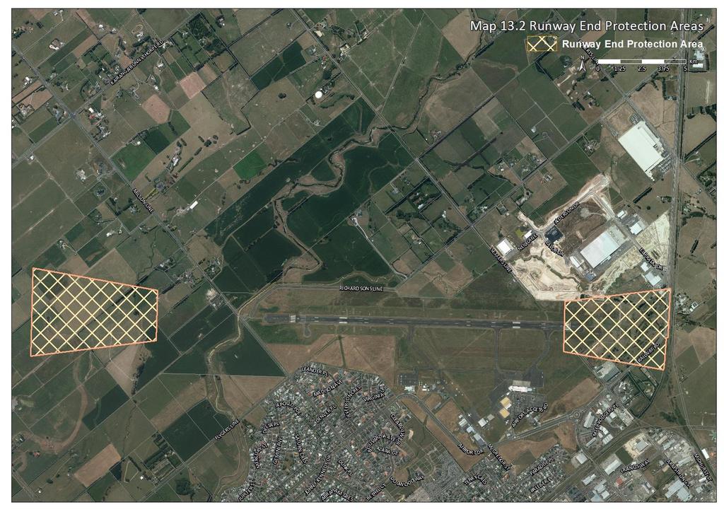
194 565
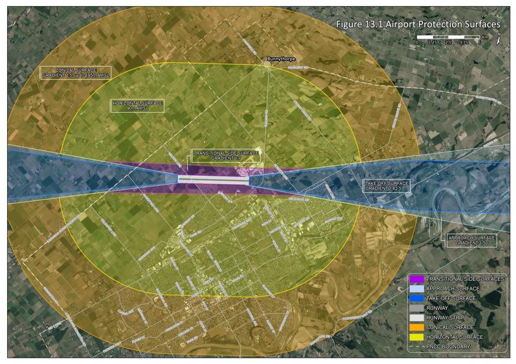
195 566
The Proposed Auckland Unitary Plan (notified 30 September 2013)
") 3 Business zones Introduction There are 10 business zones in the Unitary Plan: City Centre Metropolitan Centre Town Centre Local Centre Neighbourhood Centre Mixed Use General Business Business Park Light
3 Business zones Introduction There are 10 business zones in the Unitary Plan: City Centre Metropolitan Centre Town Centre Local Centre Neighbourhood Centre Mixed Use General Business Business Park Light
AOTEA SUPERMARKET ZONE. Zone Introduction
 C18 AOTEA SUPERMARKET ZONE Zone Introduction C18.1 Objective This zone identifies a specific area in Aotea for a stand alone supermarket. The zone is site specific and has a range of objectives, policies
I615. Westgate Precinct
 I615. Westgate Precinct I615.1. Precinct Description The Westgate Precinct is located approximately 18km west of the Auckland city centre. There are seven Sub-precincts in the Westgate Precinct: Sub-precinct
Section Three, Appendix 16C Medium Density Housing, Design Assessment Criteria (Residential 8A zone)
") APPENDIX 16C MEDIUM DENSITY HOUSING, DESIGN ASSESSMENT CRITERIA (RESIDENTIAL 8A ZONE) PURPOSE OF APPENDIX 16C (RESIDENTIAL 8A ZONE) In the Residential 8A Zone the following are defined as restricted discretionary
APPENDIX 16C MEDIUM DENSITY HOUSING, DESIGN ASSESSMENT CRITERIA (RESIDENTIAL 8A ZONE) PURPOSE OF APPENDIX 16C (RESIDENTIAL 8A ZONE) In the Residential 8A Zone the following are defined as restricted discretionary
Palmerston North City Council District Plan May 2018 BUSINESS ZONES Introduction 1
 SECTION 11: BUSINESS ZONES CONTENTS 11.1 Introduction 1 11.1.1 Function of Business Areas 1 11.1.2 Regional and Local Context of Business Areas 1 11.1.3 Natural Hierarchy of Business Areas 1 11.1.4 District
I331. St John s Theological College Precinct
 I331. St John s Theological College Precinct I331.1. Precinct Description The precinct contains the existing St John s Theological College which is a residential college for the Anglican Church in New
11.3 SPECIAL CHARACTER ZONE HAWKE S BAY REGIONAL SPORTS PARK
 11.3 SPECIAL CHARACTER ZONE HAWKE S BAY REGIONAL SPORTS PARK 11.3.1 INTRODUCTION The availability of sports and recreation activities and facilities is important for the maintenance and enhancement of
medium desnity housing
 This section updated September 2013 This part of the Plan sets out the assessment criteria for medium density housing. The criteria are designed to give designers and builders flexibility and to provide
Chapter 13 Residential Areas: Appendices APPENDIX 1 Residential Areas
 Chapter 13 Residential Areas: Appendices Page 1 Chapter 13 Residential Areas: Appendices APPENDIX 1 Residential Areas Design Code for Intensive Housing INTRODUCTION DESIGN ELEMENTS A NEIGHBOURHOOD DESIGN
I539. Smales 2 Precinct
 I539. Smales 2 Precinct I539.1. Precinct Description The Smales 2 Precinct applies to a 4.8 hectare block of land located on the southern side of Northcote Road and fronting Lake Pupuke, Takapuna. The
PART AOTEA PRECINCT
 CONTENTS... PAGE AOTEA PRECINCT...4 14.5.1 INTRODUCTION...4 14.5.2 RESOURCE MANAGEMENT ISSUES...4 14.5.3 RESOURCE MANAGEMENT OBJECTIVES AND POLICIES... 4 14.5.4 RESOURCE MANAGEMENT STRATEGY...5 14.5.5
4 RESIDENTIAL ZONE. 4.1 Background
 4 RESIDENTIAL ZONE 4.1 Background The residential areas within the City are characterised by mainly lowrise dwellings sited on individual allotments. Past architectural styles, settlement patterns and
H14. Business General Business Zone
 H14. Business General Business Zone H14.1. Zone description The Business General Business Zone provides for business activities from light industrial to limited office, large format retail and trade suppliers.
open space environment
 This section updated August 09 GUIDELINE TO THE RULES The Open Space Environment Rules apply to activities on sites within the Open Space Environment as shown on the Human Environments Maps. Most of the
Palmerston North City Council District Plan May 2018 INSTITUTIONAL ZONE Introduction Resource Management Issues 2
 SECTION 19: INSTITUTIONAL ZONE CONTENTS 19.1 Introduction 1 19.2 Resource Management Issues 2 19.3 Objectives and Policies 2 19.4 Rules: Permitted Activities 4 19.4.1 Institutional and Associated Ancillary
SCHEDULE 12 TO THE DESIGN AND DEVELOPMENT OVERLAY GLEN WAVERLEY ACTIVITY CENTRE STRUCTURE PLAN
 DD/MM/YY Proposed C120 SCHEDULE 12 TO THE DESIGN AND DEVELOPMENT OVERLAY Shown on the planning scheme map as DDO12. GLEN WAVERLEY ACTIVITY CENTRE STRUCTURE PLAN 1.0 Design objectives DD/MM/YY Proposed
4 Residential and Urban Living Zones
 4 Residential and Urban Living Zones Refer to Chapters 11 to 20 for additional rules that may apply to these zones. 4.1 OBJECTIVES AND POLICIES Objective Res1 Policy 1 Policy 2 Policy 3 Policy 4 Policy
Section Three, Appendix 17C Multiple Unit Housing Design Assessment Criteria
 APPENDIX 17C MULTIPLE UNIT HOUSING DESIGN ASSESSMENT CRITERIA Purpose of Appendix 17C In the Residential 9 Zone the construction and use of multiple household units located within the Multiple Household
12.1 Introduction Resource Management Issues Objectives and Policies Rules: Permitted Activities 8
 SECTION 12: INDUSTRIAL ZONE CONTENTS 12.1 Introduction 1 12.2 Resource Management Issues 2 12.3 Objectives and Policies 3 12.4 Rules: Permitted Activities 8 R12.4.1 Permitted Activities 8 R12.4.2 Construction,
H7 Open Space zones. (a) provide for the needs of the wider community as well as the needs of the community in which they are located;
 provide for the needs of the wider community as well as the needs of the community in which they are located;") H7. Open Space zones H7.1. Background The majority of land zoned as open space is vested in the Council or is owned by the Crown. However some areas zoned open space are privately owned. While the open
H7. Open Space zones H7.1. Background The majority of land zoned as open space is vested in the Council or is owned by the Crown. However some areas zoned open space are privately owned. While the open
Policies and Code Intent Sections Related to Town Center
 Policies and Code Intent Sections Related to Town Center The Town Center Vision is scattered throughout the Comprehensive Plan, development code and the 1994 Town Center Plan. What follows are sections
H13. Business Mixed Use Zone
 H13. Business Mixed Use Zone H13.1. Zone description The Business Mixed Use Zone is typically located around centres and along corridors served by public transport. It acts as a transition area, in terms
WELLINGTON HOSPITAL DESIGN GUIDE TABLE OF CONTENTS
 WELLINGTON HOSPITAL DESIGN GUIDE TABLE OF CONTENTS 1.0 Introduction Page 2 The Place of Wellington Hospital 2 The Future of the Hospital 2 2.0 The Intention of the Design Guide 3 3.0 Analysis 4 General
THREE PARKS ZONE Three Parks Special Zone The process of applying for resource consents in the zone.
 .25 Three Parks Special Zone The purpose of this zone is to provide for growth and to give effect to the Wanaka 2020 Community (2002) and the more recent Wanaka Structure (2007) and Wanaka Transport Strategy
11(a) AMENITY VALUES - AMENITY PLANTING. (2) Protection of notable trees and other vegetation of cultural and historical value.
 AMENITY VALUES - AMENITY PLANTING. (2) Protection of notable trees and other vegetation of cultural and historical value.") 11(a) AMENITY VALUES - AMENITY PLANTING ISSUE 1 Trees make a major contribution to urban amenities and rural landscapes and there is a lack of amenity tree planting in some parts of the District. The issue
11(a) AMENITY VALUES - AMENITY PLANTING ISSUE 1 Trees make a major contribution to urban amenities and rural landscapes and there is a lack of amenity tree planting in some parts of the District. The issue
APPENDIX MATAKANA COMMERCIAL URBAN DESIGN GUIDELINES
 APPENDIX MATAKANA COMMERCIAL URBAN DESIGN GUIDELINES 1.0 INTRODUCTION The following urban design guidelines are to be utilised by landowners, planners and other persons involved in development at early
H9. Business Metropolitan Centre Zone
 H9. Business Metropolitan Centre Zone H9.1. Zone description The Business Metropolitan Centre Zone applies to centres located in different subregional catchments of Auckland. These centres are second only
SECTION 7A: WHAKARONGO RESIDENTIAL AREA
 SECTION 7A: WHAKARONGO RESIDENTIAL AREA CONTENTS 7A.1 Introduction 1 7A.2 Resource Management Issues 1 7A.3 Objectives and Policies 1 7A.4 Methods 4 7A.5 Residential Zone 4 7A.5.1 Rules: Controlled Activities
NORTH EAST INDUSTRIAL ZONE
 SECTION 12A: NORTH EAST INDUSTRIAL ZONE CONTENTS 12A.1 Introduction 1 12A.2 Resource Management Issues 2 12A.3 Objectives and Policies 3 12A.4 Rules: Permitted Activities 8 R12A.4.1 Permitted Activities
KWE.1 Kamo Walkability Environment
 KWE.1 Kamo Walkability Environment Index KWE.1 Kamo Walkability Environment KWE.1.1 Description and Expectations KWE.1.2 Eligibility Rule KWE.1.3 Objectives KWE.1.4 District Wide Note KAP.1 Kamo Activity
This table identifies new provisions sought to be added:
 Chapter 16 Business Mixed Use This table identifies new provisions sought to be added: Appellant Court Number FII Holdings Limited ENV-2018-CHC-084 FII Holdings Limited ENV-2018-CHC-084 Universal Developments
H1. Residential Large Lot Zone
 H1. Residential Large Lot Zone H1.1. Zone description The Residential Large Lot Zone provides for large lot residential development on the periphery of urban areas. Large lot development is managed to
H10. Business Town Centre Zone
 H10. Business Town Centre Zone H10.1. Zone description The Business Town Centre Zone applies to suburban centres throughout Auckland, the satellite centres of Warkworth and Pukekohe, and the rural towns
CONTENTS 8.0 LAND USE 8.1 GENERAL LAND USE 8.2 RESIDENTIAL 8.3 MIXED USE 8.4 COMMERCIAL 8.5 EMPLOYMENT LANDS
 8-2 Land Use 8.0 LAND USE CONTENTS 8.1 GENERAL LAND USE 8.1.1 Uses provided for in all Land Use Designations 8.1.2 Uses prohibited in Hazardous Lands, Hazardous Sites and Special Policy Areas 8.1.3 Uses
RESIDENTIAL ACTIVITY PERFORMANCE STANDARDS
 Preferred Options Consultation Q&A Sheet RESIDENTIAL ACTIVITY PERFORMANCE STANDARDS What are the key goals for managing the design of residential buildings in the Second Generation Plan (2GP)? The key
6. REGIONAL AND COMMUNITY FACILITIES DESIGNATIONS 6.1. OBJECTIVES FOR REGIONAL AND COMMUNITY FACILITIES LAND USE DESIGNATIONS
 6. REGIONAL AND COMMUNITY FACILITIES DESIGNATIONS INTRODUCTION The Regional and land use designations provide the primary locations for uses which satisfy the health, education and other service needs
2A District-wide Policies
 2A Introduction This Chapter contains policies which are relevant to subdivision, use and development activities occurring across all zones and areas of the District. The policies in this Chapter implement
(DC1) Direct Development Control Provision DC1 Area 4
 Direct Development Control Provision DC1 Area 4") . General Purpose (DC) Direct Development Control Provision DC Area 4 The purpose of this Provision is to provide for an area of commercial office employment and residential development in support of the
. General Purpose (DC) Direct Development Control Provision DC Area 4 The purpose of this Provision is to provide for an area of commercial office employment and residential development in support of the
Division 13 Local Business and Industry Buffer Zone: Assessment Criteria and Assessment Tables
 Division 13 Local Business and Industry Buffer Zone: Assessment Criteria and Assessment Tables 4.13.1 Local Business and Industry Buffer Zone The provisions in this division relate to the Local Business
I404 Beachlands 2 Precinct
 I404. Beachlands 2 I404.1. Precinct Description The Beachlands 2 precinct covers approximately 6 hectares of land at the corner of Beachlands and Whitford Maraetai Roads. Its purpose is to provide for
Tāhuhu whakaruruhau ā-taone The sheltering ridge pole
 B2. Tāhuhu whakaruruhau ā-taone - Urban growth and form B2.1. Issues Tāhuhu whakaruruhau ā-taone The sheltering ridge pole Auckland s growing population increases demand for housing, employment, business,
Highland Village Green Design Guidelines
 Highland Village Green Design Guidelines Publishing Information Title Highland Village Green Design Guidelins Author The City of Calgary Status DRAFT - Proposed document subject to changes Additional Copies
Section 3b: Objectives and Policies Rural Environment Updated 19 November 2010
 Page 1 of Section 3b 3b RURAL ENVIRONMENT 3b.1 Introduction The Rural Environment comprises all the land outside of the Residential, Town Centre and Industrial Environments. Most land within the District
15 Rural Residential Zone
 15 Rural Residential Zone Section 15A 15A Purpose of the Rural Residential Zone... 1 15A.1 Objectives and Policies of the Rural Residential Zone... 1 15A.2 Activity Status Rules... 5 15A.3 Permitted Activity
Clairtrell Area Context Plan
 Clairtrell Area Context Plan March 2005 Urban Development Services City Planning Contents 1. Introduction... 4 2. Development Structure... 6 2.1 Streets... 7 2.1.1 Sheppard Avenue and Bayview Avenue...
SPECIAL 35 (HIBISCUS COAST GATEWAY) ZONE
 ZONE") `` 12.8.35 SPECIAL 35 (HIBISCUS COAST GATEWAY) ZONE 12.8.35.1 Issues The following provisions relate to the Hibiscus Coast Gateway Zone. This zone is located at Silverdale in the area bounded by State
`` 12.8.35 SPECIAL 35 (HIBISCUS COAST GATEWAY) ZONE 12.8.35.1 Issues The following provisions relate to the Hibiscus Coast Gateway Zone. This zone is located at Silverdale in the area bounded by State
22.15 OUTDOOR ADVERTISING SIGNAGE POLICY
 22.15 OUTDOOR ADVERTISING SIGNAGE POLICY This policy applies to all land where a planning permit is required to construct or display a sign under the provisions of the Kingston Planning Scheme. 22.15-1
Buildings may be set back to create small plazas provided that these setbacks do not substantially disrupt the street wall s continuity.
 6-22 Community Design Street Walls and Street-front Setbacks The siting of buildings will play a critical role in establishing the character and sense of place for the District. Siting buildings at the
Cape Cabarita (Formerly known as the Wellcome Site) Development Control Plan. Date of Adoption: 4 September 2007 Effective Date: 7 March 2008
 Development Control Plan. Date of Adoption: 4 September 2007 Effective Date: 7 March 2008") Cape Cabarita (Formerly known as the Wellcome Site) Development Control Plan Date of Adoption: 4 September 2007 Effective Date: 7 March 2008 Development Control Plan Index 1 INTRODUCTION...3 1.1 LAND TO
Cape Cabarita (Formerly known as the Wellcome Site) Development Control Plan Date of Adoption: 4 September 2007 Effective Date: 7 March 2008 Development Control Plan Index 1 INTRODUCTION...3 1.1 LAND TO
Residential Design Guide
 Residential Design Guide Table of Contents INTRODUCTION - Application - Intentions - Interpretation 1 Character - Complementing neighbourhood character - Consistency or contrast - Landform - Vegetation
Ensure that development within the Arrowtown Urban Growth Boundary provides:
 URBAN DEVELOPMENT 4 4.2.5.2 Ensure that development within the Arrowtown Urban Growth Boundary provides: an urban form that is sympathetic to the character of Arrowtown, including its scale, density, layout
EXISTING COMPREHENSIVE PLAN
 EXISTING COMPREHENSIVE PLAN Town Center Land Use Element: V. LAND USE POLICIES Town Center Mercer Island's business district vision as described in "Your Mercer Island Citizen-Designed Downtown" was an
TABLE OF CONTENTS 1.0 INTRODUCTION... 3
 TABLE OF CONTENTS 1.0 INTRODUCTION... 3 1.1. BACKGROUND... 3 1.2. THE PROPOSAL... 5 2.0 EXISTING POLICY FRAMEWORK... 5 2.1. PROVINCIAL POLICY STATEMENT (PPS)... 5 2.2. CITY OF LONDON OFFICIAL PLAN (OP)...
6.6.2 Emerging Community Zone Code Application Purpose and overall outcomes. s6 Zone Codes Emerging Community and Township Zone Codes
 6.6.2 Emerging Community Zone Code 6.6.2.1 Application This code applies to assessable development:- (1) within the Emerging Community Zone as identified on the zoning maps contained within Schedule 2
Division 12 Community Use Code
 Division 12 Community Use Code 12.12.1 Community Use Code (v) provide reasonable buffers between incompatible uses and zones or Sub Areas; (1) The provisions in this division comprise the Community Use
Urban Design Guide For Commercial Development in Urban Areas
 Urban Design Guide For Commercial Development in Urban Areas Our Goal Gisborne s commercial zones become more successful through quality urban design. Contents Introduction 2 Streamlining the planning
Subdivision Design Criteria. Penihana North GUIDELINES TO THE RULES
 Created September 2013 Penihana North Subdivision Design Criteria GUIDELINES TO THE RULES This part of the Plan sets out the design criteria for subdivision in Penihana North. The criteria will be considered
REMARKABLES PARK ZONE
 .10 Remarkables Park Zone.10.1 Resources, Activities and Values The Remarkables Park Area comprises approximately 150 hectares of perimeter urban land in the vicinity of Frankton and occupies a strategic
97 Lea Bridge Road, Leyton, E10 7QL London Borough of Waltham Forest December 2015
 97 Lea Bridge Road, Leyton, E10 7QL London Borough of Waltham Forest December 2015 Public Realm and Landscape Proposals LEA BRIDGE ROAD, WALTHAMSTOW Public Realm & Landscape Proposals BDP(90)RPT001 December
Nelson Residential Street Frontage Guideline
 DRAFT 22-06-2012 Nelson Residential Street Frontage Guideline June 2012 1317273 Contents and purpose Residential s are important Residential s are much more than corridors which move traffic. Streets allow
Regency Developments. Urban Design Brief. Holyrood DC2 Rezoning
 Regency Developments Urban Design Brief Holyrood DC2 Rezoning Stantec Consulting Ltd. 7-31-2017 1. Overview Regency Developments intends to rezone the lands located at 8510 and 8511 93 Avenue, within the
I209 Quay Park Precinct
 I209. Quay Park I209.1. Precinct description The Quay Park Precinct is located on reclaimed land at the eastern end of the city centre and along the City Centre waterfront. It is dissected to the east
I207. Learning Precinct
 I207. Learning Precinct I207.1. Precinct description The Learning Precinct is centred on the Symonds Street ridge where the University of Auckland and Auckland University of Technology have the majority
Plan Modification to Chapter B2 of the Auckland Unitary Plan(AUP) Operative in part (15 November 2016)
 Operative in part (15 November 2016)") UNITARY PLAN UPDATE REQUEST MEMORANDUM TO FROM Phill Reid Linley Wilkinson DATE 25 September 2018 SUBJECT Plan Modification to Chapter B2 of the Auckland Unitary Plan(AUP) Operative in part (15 November
UNITARY PLAN UPDATE REQUEST MEMORANDUM TO FROM Phill Reid Linley Wilkinson DATE 25 September 2018 SUBJECT Plan Modification to Chapter B2 of the Auckland Unitary Plan(AUP) Operative in part (15 November
Urban Design Site Assessment
 1150 Great North Road/8 Parr Road North, Point Chevalier Urban Design Site Assessment (8th February 2017) 1. Introduction and Overview 0B It is proposed to develop land at 1150/1158 Great North Road and
CITY OF MERCER ISLAND DESIGN COMMISSION STAFF REPORT
 CITY OF MERCER ISLAND DESIGN COMMISSION STAFF REPORT Agenda Item: 2 March 9, 2011 Project: Description: Applicant: DSR11-004 The applicant is requesting approval to replace the existing exterior wood framed
Guidance Notes Completing an AEE
 Guidance Notes Completing an AEE The purpose of this guidance note is to assist you with completing your Assessment of Environmental Effects (AEE) for your land-use consent application. If you do not provide
Development Control Plan
 Development Control Plan Rhodes Corporate Park (Also known as the Digital Site) Development Control Plan Date of Adoption: 4 September 2007 Effective Date: 7 March 2008 Index 1 INTRODUCTION... 3 1.1 LAND
WEST LOOP DESIGN GUIDELINES CHECKLIST
 WEST LOOP DESIGN GUIDELINES CHECKLIST Section 1.0 General Strategies 1.1 DESIGN EXCELLENCE: ENCOURAGE HIGH QUALITY AND INNOVATIVE DESIGN OF NEW BUILDINGS WITHIN THE WEST LOOP WITHOUT BEING PRESCRIPTIVE
18 Industrial Zones. Section 18A. Appendices
 18 Industrial Zones Section 18A 18A Purpose of the Industrial Zones... 1 18A.1 Purpose of the Industry Zone... 1 18A.2 Purpose of the Port Industry Zone... 1 18A.3 Purpose of the Tauriko Industry Zone...
and services The protection and conservation of environmentally significant and sensitive natural heritage features and functions.
 6. Land Use 6.0 Preamble A healthy and livable city is one in which people can enjoy a vibrant economy and a sustainable healthy environment in safe, caring and diverse neighbourhoods. In order to ensure
PART 6 - HUMAN ENVIRONMENT
 CONTENTS...PAGE 6.1 INTRODUCTION...3 6.2 ISSUES AND STRATEGY...3 ISTHMUS SECTION - OPERATIVE 1999 Page 1 Page 2 ISTHMUS SECTION - OPERATIVE 1999 PART 6 - HUMAN ENVIRONMENT 6.1 INTRODUCTION The Plan seeks
25 Crime Prevention through Environmental Design (CPTED)
") Volume 2: Assessment of Environmental Effects 412 25 Crime Prevention through Environmental Design (CPTED) Overview The purpose of this Chapter is to provide a Crime Prevention Through Environmental Design
Volume 2: Assessment of Environmental Effects 412 25 Crime Prevention through Environmental Design (CPTED) Overview The purpose of this Chapter is to provide a Crime Prevention Through Environmental Design
6 Site Framework Strategies
 6 Site Framework Strategies 6.1 Introduction Section 6 identifies a number of specific areas which are considered to be key sites within the Plan area and which may have potential for development / redevelopment.
Keystone Business Park Precinct Structure Plan North East Industrial Precinct. Part 2 Design Principles
 Keystone Business Park Precinct Structure Plan North East Industrial Precinct Part 2 Design Principles Context Issues Services Landform Issues Geotech and contamination Ecology Traffic and access Issues
STATEMENT OF OBJECTION TO THE PROPOSED DEVELOPMENT OF LAND AT CHURCH CLIFF DRIVE FILEY
 STATEMENT OF OBJECTION TO THE PROPOSED DEVELOPMENT OF LAND AT CHURCH CLIFF DRIVE FILEY You will be aware that Scarborough borough council have adopted a new local plan that includes land at Church Cliff
ASSESSMENT OF LANDCAPE PROVISIONS FOR PROPOSED PLAN CHANGE 5. Local Business Zone PALMERSTON NORTH CITY COUNCIL FINAL
 Hawke s Bay Office: PO Box 8823 Havelock North john@hudsonassociates.co.nz Ph 06 877 9808 M 021 324 409 A division of Hudson Group Ltd ASSESSMENT OF LANDCAPE PROVISIONS FOR PROPOSED PLAN CHANGE 5 Local
RESIDENTIAL. QLDC PROPOSED DISTRICT PLAN [PART THREE] DECISIONS VERSION 8 medium density residential
![RESIDENTIAL. QLDC PROPOSED DISTRICT PLAN [PART THREE] DECISIONS VERSION 8 medium density residential](/thumbs/84/89275880.jpg "RESIDENTIAL. QLDC PROPOSED DISTRICT PLAN [PART THREE] DECISIONS VERSION 8 medium density residential") 8 MEDIUM DENSITY RESIDENTIAL QLDC PROPOSED DISTRICT PLAN [PART THREE] DECISIONS VERSION 8 medium density residential QLDC PROPOSED DISTRICT PLAN [PART THREE] DECISIONS VERSION 8 medium density residential
8 MEDIUM DENSITY RESIDENTIAL QLDC PROPOSED DISTRICT PLAN [PART THREE] DECISIONS VERSION 8 medium density residential QLDC PROPOSED DISTRICT PLAN [PART THREE] DECISIONS VERSION 8 medium density residential
MASTER PLAN NO. 60 (SITE DEVELOPMENT PLAN EASTBANK/REGATTA NORTH PRECINCTS 2 4) 2008
 2008") Page 2 TABLE OF CONTENTS PAGE 1 PRELIMINARY... 5 1.1 CITATION... 5 1.2 TYPE OF MASTER PLAN... 5 1.3 LEGAL REQUIREMENT FOR MASTER PLAN... 5 1.4 LEGAL EFFECT OF THE MASTER PLAN... 5 2 DESCRIPTION OF LAND...
Page 2 TABLE OF CONTENTS PAGE 1 PRELIMINARY... 5 1.1 CITATION... 5 1.2 TYPE OF MASTER PLAN... 5 1.3 LEGAL REQUIREMENT FOR MASTER PLAN... 5 1.4 LEGAL EFFECT OF THE MASTER PLAN... 5 2 DESCRIPTION OF LAND...
Appendix 1. Amendments to Christchurch City Council s District Plan
 Appendix 1 Amendments to Christchurch City Council s District Plan Contents Rārangi Upoko Introduction... 1 Central City Business Zone... 3 Central City Mixed Use Zone... 15 Conservation 5 Zone... 25
Mark-up of the effect of the proposed Bronte Village Growth Area OPA No.18 on the text of section 24, Bronte Village, of the Livable Oakville Plan
 Mark-up of the effect of the proposed Bronte Village Growth Area OPA No.18 on the text of section 24, Bronte Village, of the Livable Oakville Plan Notes: This document is provided for information purposes
appendix and street interface guidelines
 appendix five: building and street interface guidelines appendix 5 building and street interface guidelines BOULEVARDS Boulevards are generally characterized by higher levels of traffic movement at higher
FRUITVALE TRANSIT VILLAGE (Phase 2) Residential Project
 Residential Project") FRUITVALE TRANSIT VILLAGE (Phase 2) Residential Project DEVELOPER: SIGNATURE PROPERTIES ARCHITECT: HKIT ARCHITECTS April 23, 2010 TABLE OF CONTENTS 3 Vision 4 Description of Site 5 Guiding Concepts 6
FRUITVALE TRANSIT VILLAGE (Phase 2) Residential Project DEVELOPER: SIGNATURE PROPERTIES ARCHITECT: HKIT ARCHITECTS April 23, 2010 TABLE OF CONTENTS 3 Vision 4 Description of Site 5 Guiding Concepts 6
Road transport activities and infrastructure can have adverse effects on the environment and community.
 22 Road Transport 22.1 Significant Issues Road transport activities and infrastructure can have adverse effects on the environment and community. Land use activities can have adverse effects on the safety
1 The development hereby permitted shall be carried out in accordance with the following approved plans:
 Location 59 Greenway Close London N20 8ES Reference: 16/00011/HSE Received: 30th December 2015 Accepted: 7th January 2016 Ward: Totteridge Expiry 3rd March 2016 Applicant: Mr Ankit Shah Proposal: Part
Built Form and Massing
 Initial Urban Design Assessment Former Gasworks Site, 111 Queens Parade and 433 Smith Street, Fitzroy North Prepared for Protect Fitzroy North Incorporated by David Pryor, Place Design Studio 6 April 2018
Section 6A 6A Purpose of the Natural Features and Landscapes Provisions
 Section 6A 6A Purpose of the Natural Features and Landscapes Provisions This Chapter addresses the protection and management of natural features and landscapes within the City. The City has a number of
The West Vaughan Employment Area Secondary Plan Policies
 Part 2: The West Vaughan Employment Area Secondary Plan Policies 2.1 General Policies It is the policy of Council: 2.1.1. That the West Vaughan Employment Area (the WVEA), identified on Schedule 1, will
MVRC ARCHITECTURAL DESIGN STATEMENT
 11251 MOONEE VALLEY RACING CLUB MAY 201 CONTENTS 0 Contents Introduction 1 Site Analysis a. Site Features b. Built form Interfaces c. Existing Streetscape d. Site Opportunities and Constraints 2 Masterplan
URBAN DESIGN BRIEF URBAN DESIGN BRIEF 721 FRANKLIN BLVD, CAMBRIDGE August 2018
 URBAN DESIGN BRIEF URBAN DESIGN BRIEF 721 FRANKLIN BLVD, CAMBRIDGE August 2018 DESIGN BRIEF CONTENTS PART A 1.0 INTRODUCTION 2.0 DESCRIPTION & ANALYSIS OF SITE CONTEXT 3.0 DESIGN CONSTRAINTS AND OPPORTUNITIES
Uptown Rideau Street Secondary Plan [Amendment #166, January 12, 2016]
![Uptown Rideau Street Secondary Plan [Amendment #166, January 12, 2016]](/thumbs/76/73760497.jpg "Uptown Rideau Street Secondary Plan [Amendment #166, January 12, 2016]") [Amendment #166, January 12, 2016] The policies of this Secondary Plan are in effect, save and except for the property at 560 Rideau Street, for which there remains a site specific appeal to this Secondary
[Amendment #166, January 12, 2016] The policies of this Secondary Plan are in effect, save and except for the property at 560 Rideau Street, for which there remains a site specific appeal to this Secondary
Memorial Business Park Site. Proposed Future Development. Design guidelines. August
 Memorial Business Park Site Proposed Future Development Design guidelines August 2014 www.designenvironment.co.nz 0064 3 358 3040 Contents 1.0 Background 1.1 Introduction 3 1.2 Objectives 4 2.0 Context
Section 12C Subdivision in the Rural Residential Zone
 Section 12C 12C Subdivision in the Rural Residential Zone The Rural Residential Zone provides part of the range of residential opportunities within the City. Land zoned rural residential is considered
APPENDIX 10 THE RESIDENTIAL DESIGN GUIDE FOR DEVELOPMENTS IN RESIDENTIAL ZONES IN SPECIFIED GROWTH AREAS
 THE RESIDENTIAL DESIGN GUIDE FOR DEVELOPMENTS IN RESIDENTIAL ZONES IN SPECIFIED GROWTH AREAS ISTHMUS SECTION - OPERATIVE 1999 Page 1 CONTENTS... PAGE 1.0 INTRODUCTION... 4 1.1 Growth Management Strategy...
Mixed Use Centres Development Permit Guidelines
 1 Mixed Use Centres Development Permit Guidelines Area Commercial or Mixed Use development occurring in City Centre, Urban Centre, Neighbourhood Centre, or Institutional Complex land use designations is
Town Center (part of the Comprehensive Plan)
") Town Center (part of the Comprehensive Plan) Mercer Island Town Center Looking North (2014) In 1994, a year-long process culminated in a set of design guidelines and code requirements for the Town Center
Town Center (part of the Comprehensive Plan) Mercer Island Town Center Looking North (2014) In 1994, a year-long process culminated in a set of design guidelines and code requirements for the Town Center
UNIVERSITY TOWN NEIGHBOURHOODS 5.5 HOUSING MELBOURNE CAMPUS MASTER PLAN 2014
 5.5 169 EXISTING CONDITIONS & VISION NEIGHBOURHOOD VISION The provision of on-campus housing into the future will continue to be an important element of the La Trobe University experience. A long-term
PART 3 - RESOURCE MANAGEMENT
 CONTENTS... PAGE 3.1 INTRODUCTION... 3 3.2 NATURAL AND PHYSICAL ENVIRONMENT... 3 3.3 URBAN SUSTAINABLE MANAGEMENT... 5 3.4 RESOURCE MANAGEMENT ISSUES... 5 3.5 RESOURCE MANAGEMENT OBJECTIVES AND POLICIES...
PINE HARBOUR MARINA ZONE PLAN CHANGE NO
 PINE HARBOUR MARINA ZONE PLAN CHANGE NO. 34 TO THE AUCKLAND COUNCIL DISTRICT PLAN (MANUKAU SECTION) PURSUANT TO THE FIRST SCHEDULE TO THE RESOURCE MANAGEMENT ACT 1991 1 REPLACE Planning Map No. 57 with
FRASER LANDS CD-1 GUIDELINES (BLOCKS 68 AND 69) Adopted by City Council April 1989
 Adopted by City Council April 1989") $1 City of Vancouver Land Use and Development Policies and Guidelines Community Services, 453 W. 12th Ave Vancouver, BC V5Y 1V4 F 604.873.7344 fax 873.7060 planning@city.vancouver.bc.ca FRASER LANDS CD-1
$1 City of Vancouver Land Use and Development Policies and Guidelines Community Services, 453 W. 12th Ave Vancouver, BC V5Y 1V4 F 604.873.7344 fax 873.7060 planning@city.vancouver.bc.ca FRASER LANDS CD-1