WELLS BRANCH PARKS MASTER PLAN JULY 01, 2014 The information shown is based on the best information available and is subject to change without notice.
|
|
|
- Jonah Williamson
- 5 years ago
- Views:
Transcription

1 WELLS BRANCH PARKS MASTER PLAN JULY 01, 2014 The information shown is based on the best information available and is subject to change without notice.
2
3 TABLE OF CONTENTS PHASE 1: MASTER PLAN ANALYSIS...02 SITE CONTEXT...03 INTRODUCTION MASTER PLAN ANALYSIS MASTER PLAN ANALYSIS...06 PROJECTS OUTSIDE OF MASTER PLAN...07 EXISTING PARK ANALYSIS...11 CONCLUSION...19 PHASE 2: PUBLIC INPUT...25 OVERVIEW...26 PUBLIC INPUT APPROACH...28 PUBLIC INPUT FINDINGS...29 RECOMMENDATIONS - PARK PRIORITIES...30 PHASE 3: MASTER PLANDESIGN...32 OVERVIEW - MASTER PLAN DESIGN...34 MASTER PLAN...35 PROGRAM ELEMENTS - DETAILS...37 NORTH MEADOW...38 GAYLORD TRAIL & WEST LOOP...41 EAST MEADOW...43 RECREATION CENTER & WILLOW BEND PARK...46 SHORELINE PARK...49 OVERALL PARK IMPROVEMENTS...52 TRAIL CONNECTIVITY DIAGRAM...53 LIGHTING DIAGRAM...55 TRAIL IMPROVEMENTS DIAGRAM...57 SIGNAGE & WAYFINDING RECOMMENDATIONS...59 FINAL CONCLUSION...60
4
5 PHASE I - MASTER PLAN ANALYSIS 2

6 I 35 Mopac Expy Scofield Ridge Pkwy 3 SITE CONTEXT
7 INTRODUCTION Since its beginning, the Wells Branch Municipal Utility District has been supported by directors and developers who have helped create an extensive park system, providing residents the opportunity to interact with each other through passive and active recreation. The park system has evolved throughout the years, including many improvements to areas that were once considered wasted space. The Wells Branch community can be defined by its unique park elements, which include the trail system, swimming pool, field and court sports, playscapes, picnicking areas and nature walks. The park s first master planning process began in 1989 with 80 acres of parkland, drainage easements and floodplains. Since then, the park has developed miles of trails, pedestrian bridges, picnic pavilions and other park improvements through grant funds. As the popularity for this park system grows, there are also opportunities for growth to its existing framework. TBG was hired in January 2014 to review the existing parks master plan, provide recommendations for unrealized projects within the existing master plan, inventory all assets within the parks and open space system, and hold public input meetings to develop an updated master plan for the Wells Branch Municipal Utility District in Austin, Texas. Three phases of the project: 1. Master Plan Review This process will begin with a thorough analysis of the master plans that were completed in the past as well as projects that have been completed or planned outside of any formal master planning effort. Maintenance plans will be reviewed as well as current conditions of the existing parks. 2. Public Input Process Upon completion of the master plan review, TBG will engage the public to determine community desires for the parks and open space improvements. As part of this phase, TBG will facilitate two public meetings and prepare an online survey to gain insight on residents priorities. 3. Master Plan Update The final phase in the process will be to incorporate the overall results of the previous tasks into a comprehensive parks and open space master plan update with recommendations, phasing and budgets to guide future open space development within Wells Branch. INTRODUCTION WELLS BRANCH PARKS MASTER PLAN JULY 1, 2014 The information shown is based on the best information available and is subject to change without notice. 4

8 The 1996 Wells Branch Park Master Plan was prepared in April 1996 by Hinman Halford Architects and Winterowd & Associates. The document gave an overview of previously completed park Master plan projects and analyzed park elements requested during the public input period. At the time, the community overwhelmingly ranked soccer fields as the highest priority, while interest in an outdoor sports center, an indoor sports center, a teen center, upgraded playscapes, sand volleyball, a weight room, improved walking trails, a skateboard track and baseball practice areas ranked highly among those polled. In addition, the master plan proposed amendments to the previous master plan that were to be implemented in a five-year improvement plan. The amendments to the Parks Master Plan included: Central Park improvements (currently known as Katherine Fleischer Park), District Office facility expansion, a proposed indoor recreation center, a proposed Sports Complex at Bratton Park, a Sports Center at Willow Run, creation of East Creek Park and a West Loop Mini- Park. Of the proposed amendments, the improvements to the Central Park were executed to the greatest extent. The District focused on expanded parking, expanding the district office, and expanded meeting rooms at the community center. The new hike-and-bike trail was extended through the West Loop Trail area. However, the indoor recreational facility, East Creek Area Park, Bratton Lane Sports Complex and the Willow Run Sports Complex that were proposed were not implemented. Original 1996 Wells Branch Park Master plan Hinman Halford Architects and Winterowd & Associates MASTER PLAN ANALYSIS

9 The 1999 Wells Branch Parks and Recreation Master Plan was prepared for the Board of Directors in January 1999 by Larson/Burns Landscape Architects and Park Planners. This document brought the master plan up to speed with the growing community and current goals of the District for recreational services and facilities at that time. The document summarized the process of community involvement in the previous master plans and re-assessed the Survey/Workshop Summary Chart. Much like the 1996 document, this master plan booklet looked at the public s recreational preferences while assessing the resources and abilities of the District to accommodate their recreational desires. This document addressed the District constraints that inhibited the implementation of the proposed amendments from the 1996 plan that were not completed. The document also listed pertinent information on how the existing parks met developed park standards for a variety of recreational experiences. Public input preferences for recreation improvements were rated and, again, soccer fields, an outdoor sports center, indoor sports center, teen center and children s play areas were ranked in the top five for importance to the community. The plan laid out recommendations in a six-year cycle of implementation, spanning from 1999 to 2005 in two phases. Phase 1 included completion of the Central Park improvements while Phase 2 included enhancements at Mills Pond, North Meadow trail connections and improvements, additional trails and enhancements in the North Meadow, a new hike-and-bike trail and pocket park at the West Loop Trail, and a pool, picnic facilities, playground, basketball court and softball field at Willow Bend Park. Except the proposed pocket park with playscape at the West Loop Trail, all of the improvement recommendations in the six-year plan were implemented. Original 1996 Wells Branch Park Master plan Hinman Halford Architects and Winterowd & Associates 1999 MASTER PLAN ANALYSIS WELLS BRANCH PARKS MASTER PLAN 6 JULY 1, 2014 The information shown is based on the best information available and is subject to change without notice.


10 In the years since the 1996 and 1999 master plans were adopted, many projects have been completed or planned upon the direction of the Board. These projects have been pursued based on maintenance needs as well as overall trends for recreation and community interests. The most notable projects that have been implemented are: DOG PARK Within Wells Branch, there are currently two off-leash areas. The first is located off Bratton Lane while the second is located along the trail east of Wells Port Drive. Located in MUD detention ponds, the parks offer extensive open space for dogs to run freely with little required investment to designate as an amenity. DISC GOLF GROW ZONES Grow zones have been established in many areas within the Wells Branch parks system. Originally established through a pilot program and implemented along the creeks, natural riparian habitats have been implemented to improve water quality, stabilize creek bank erosion, provide wildlife habitats, promote native plant growth and reduce maintenance. Signage has been strategically placed to raise awareness and promote environmental stewardship within the community. These efforts appear to be wellreceived, successful where started and a great value to the community. DOG PARK DISC GOLF Located south of Wells Branch Park, the 18-hole disc golf course was first established in 1996 as a nine-hole course. It is a popular course as it is suitable for beginners as well as experienced participants who are looking for a challenge. Located along the creek and hills in the naturally wooded area in East Creek Park, the course offers concrete tee pads, signage and benches that were added due to the course s popularity in April GROW ZONES 7 PROJECTS OUTSIDE OF MASTER PLAN


11 TREES FOR TRAILS After noticing that many of the trees within the park system had been lost due to age, weather or climate change, the Wells Branch MUD Facilities Committee started an advisory group to get the community excited and involved in the Trees for Trails Campaign. This group established a master plan to guide this program. Individual community members, local businesses and groups have supported the program since its inception and, to date, approximately 200 trees have been planted within the Wells Branch parks. MILLS POND PARK Additional phases include structural improvements to the dam and improved access to the adjacent shoreline, incorporating creative and natural play elements for children, improved trails, added shade trees and native planting, shore stabilization, and improved water quality. TREES FOR TRAILS MILLS POND PARK Within the last year, many improvements have been made to Mills Pond and the surrounding park. Originally spearheaded by a grassroots Pond Team, the Pond Master Plan has progressed and two phases have been completed to date. Phase 1 Upgrades included new trees, transition zone and aquatic plantings, and additional seating and picnic areas on the pond s east bank. Phase 2 includes the meditation and memorial garden improvements on the west side of Mills Pond. Recent work includes memorial rock placement, connection trials, improved shoreline, seating and picnic areas, and additional transition zone and aquatic plantings. MILLS POND PARK PROJECTS OUTSIDE OF MASTER PLAN WELLS BRANCH PARKS MASTER PLAN 8 JULY 1, 2014 The information shown is based on the best information available and is subject to change without notice.

12 PREVIOUSLY PROPOSED VELOWAY Proposed at the LCRA easement on Merrilltown Road, the plan for the veloway or bike loop was permitted and documents were submitted and made ready for construction. However, at some point concerns were raised about the appropriateness of the design and the project has been on hold since. An existing gravel path is still in place. 9 PROJECTS OUTSIDE OF MASTER PLAN

13 PREVIOUSLY PROPOSED NATURE PARK The parcel of land where the nature park was planned is located on Wells Branch Parkway, neighboring the St. Andrews Presbyterian Church. The parcel was purchased several years ago and planning was initiated for a nature park and outdoor classroom. Planned elements included vehicular access from Wells Port Drive with parking and turnaround for arrival. Nature play elements included water play, play mounds, a butterfly garden, sand pits, exploratory opportunities in the existing wooded area as well as a picnic pavilion and flexible picnic areas. Again, once the drawings were permitted and ready for bidding, the project was put on hold due to conflict about whether this was the most appropriate parcel for nature play. PROJECTS OUTSIDE OF MASTER PLAN WELLS BRANCH PARKS MASTER PLAN 10 JULY 1, 2014 The information shown is based on the best information available and is subject to change without notice.
14 11 EXISTING PARK ANALYSIS


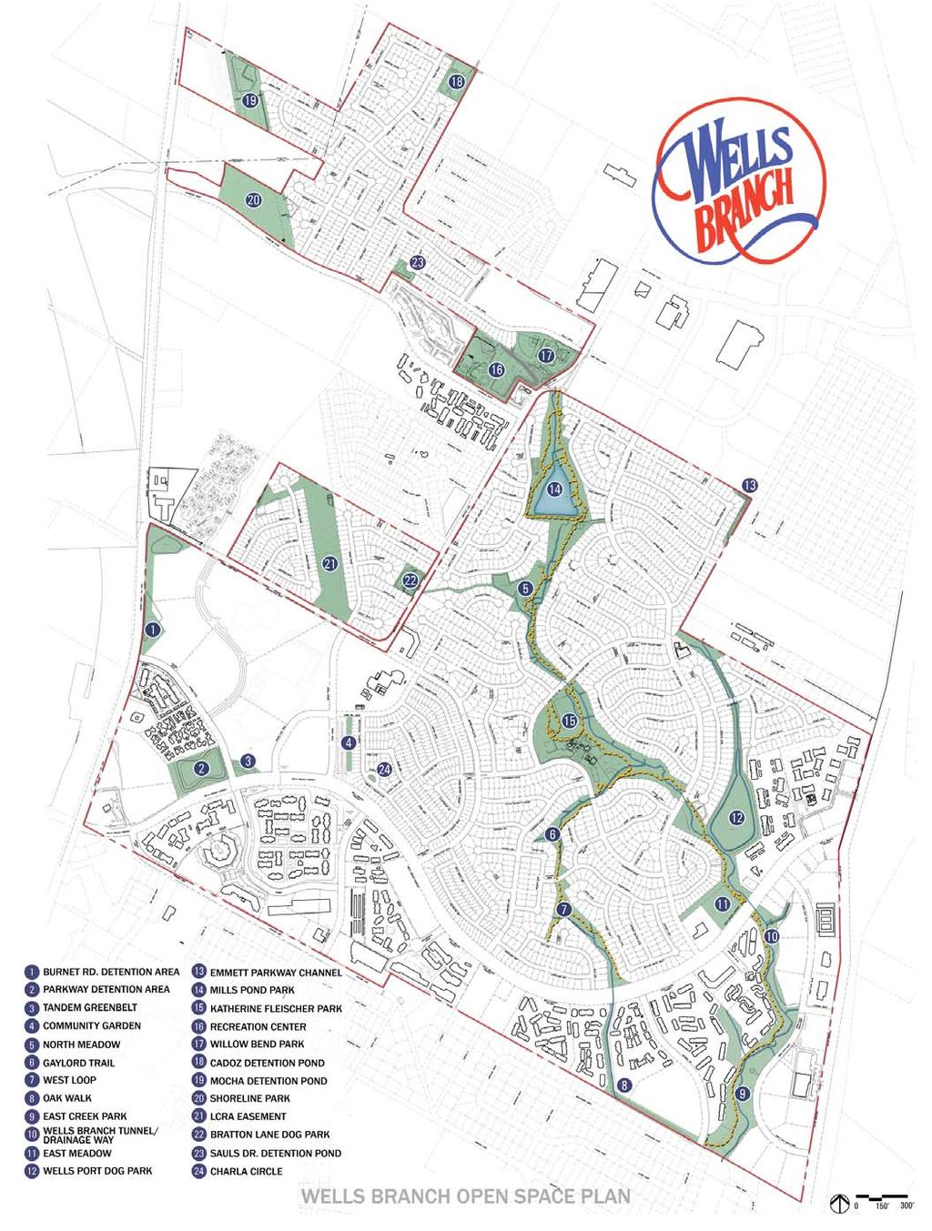
15 1 BURNET RD. DETENTION AREA Located along Burnet Road and the Mopac Expressway access road, this open space is owned by HP and maintained by the District on a monthly basis as a detention easement. The parcel is constrained by a lack of safe access for potential users and future recreational opportunities may be limited due to the configuration and location of the site. 2 PARKWAY DETENTION AREA With an excellent location and access at the northwest corner of Wells Branch Parkway and Tandem Boulevard, this 6.6-acre detention pond is a valuable open space worthy of consideration for more active uses. A portion of the site contains a concrete drainage channel that may limit some potential uses. 3 TANDEM GREENBELT Located across Tandem Boulevard from the Parkway Detention Pond, the Tandem Greenbelt contains detention ponds in addition to tree cover and natural areas as well. The site is owned by HP and the District maintains the property for detention purposes. If permitted with ownership, this site may be suitable for trail connections to adjacent uses or more passive recreation. EXISTING PARK ANALYSIS WELLS BRANCH PARKS MASTER PLAN 12 JULY 1, 2014 The information shown is based on the best information available and is subject to change without notice.


16 4 COMMUNITY GARDEN Located at the corner of Town Hill Drive and Single Trace, a fully enclosed and secure 5-acre parcel of land was developed into the popular Wells Branch Community Garden. All 10 x 20 garden plots are equipped with water and a hose. The garden appears to be full and the enclosure fence helps maintain a tidy appearance from the exterior. 5 NORTH MEADOW Consisting of approximately 12.3 acres in the north central part of the park system, the park has a connection trail linking Katherine Fleisher Park to Mills Pond and the surrounding neighborhoods. The north end of the meadow is anchored by a small playscape for 2- to 5-year-olds with an associated pavilion. The playscape lacks shaded seating in its adjacent areas and has limited play value. A small digging play apparatus and picnic/seating locations are located along the path on the park s southern end. Overall, North Meadow s layout it a bit disjointed but offers ample open space for recreational opportunities. 6 GAYLORD TRAIL This segment of the trail system has been minimally developed as a connection path between Katherine Fleischer Park and West Loop. The common space of one trail segment features built structures and landscaping that were installed by a resident whose lot backs up to the green space. Most of the trail path is decomposed granite and a portion of the trail has been elevated to traverse a drainage swale. The turf is has spotty establishment and the majority of the trail is not shaded. 13 EXISTING PARK ANALYSIS


17 7 WEST LOOP Serving primarily as a connection trail from Gaylord Drive to Alex Trail and Wells Branch Parkway, the West Loop is spotted with shade trees but lacks a destination for recreation. One small picnic area exists with limited shade. Drainage along the existing path appears to be an ongoing maintenance problem and the landscape at the tunnel under Wells Branch is barren and lacking curb appeal. 8 TOM ALBIN OAK WALK A shaded connection path along a drainage way in the southernmost portion of Wells Branch, this portion of the trail is concrete and one of the narrowest stretches of trail in the system. The portion of the connection trail running from east to west is owned by Pflugerville ISD. The District has an interlocal agreement regarding access and this will have to be thoroughly investigated prior to proposing any improvements to this segment. 9 EAST CREEK PARK This linear park is currently home to an 18-hole disc golf course. A connection trail runs along the creek s west side close to the apartment complex while Owen-Tech Boulevard serves as the eastern boundary, providing parking along the street for disc golf users. Individual disc golf holes show wear from use, portions of the creek present signs of erosion, and the decomposed granite trail has been washed out in several locations. There are multiple bridge crossings for foot traffic with no connection to the main trail or the trails along the park s east side. EXISTING PARK ANALYSIS WELLS BRANCH PARKS MASTER PLAN 14 JULY 1, 2014 The information shown is based on the best information available and is subject to change without notice.


18 10 WELLS BRANCH TUNNEL/ DRAINAGE WAY Riparian repair efforts and dedicated grow zones have been incorporated into this area. The trail connection under Wells Branch Parkway has drainage issues, preventing pedestrians and cyclists from using the tunnel without going through significant mud and water from the creek. 11 EAST MEADOW With frontage on Wells Branch Parkway and access to Wells Port Drive, this undeveloped 2-acre parcel has great connection possibilities to the adjacent creek trail and greenbelt. The topography slopes down to Wells Branch and the majority of the tree cover is located on the parcel s east side near the adjacent trail. Just north of Wells Branch Parkway, where the stream and trail bend, informal planting and stream restoration have taken place in the last few years. The area has several seating opportunities with scattered benches. However, these areas lack shade, connection walks or main greenway trails on the creek s east side. 12 WELLS PORT DOG PARK Located in a large detention basin along the trail, this dedicated off-leash area provides a large open space for dogs to run but has limited seating and shade provided for users. There is a decomposed granite walk to the main trail for access, but it s not a fluid connection as part of the overall trail loop. 15 EXISTING PARK ANALYSIS


19 13 EMMETT PKWY CHANNEL The District maintains this narrow easement behind the lots on the edge of Wells Branch. The open space with overhead power lines provides minimal to no value for usable public open space. 14 MILLS POND PARK This much-loved pond in the Wells Branch community offers a fishing pier, canoe dock, shaded walk along a dam, areas for picnicking and passive recreation, and a meditation garden. The fishing pier gives residence a great opportunity to be on the water but it is in need of repair and refurbishment. More shade is needed as well as more defined separation between the fishing and recreation areas. 15 KATHERINE FLEISCHER PARK Centrally located in the community, Katherine Fleisher Park is a hub of activity offering a multitude of recreation activities. This large 22-acre park is currently home to the community center, historic homestead, pool and amenity area, a large playscape area with pavilion and playhouse, two tennis courts, a full-size basketball court, sand volleyball court, baseball field and pavilion. Concrete walks along Klattenhoff Drive tie into the interior system of decomposed granite paths and trails and connect to other areas of the park system. The traditional play elements in the playscape area have recently been replaced, although limited seating is provided at this heavily used amenity. The playhouse is a unique feature that is showing its age. Additionally, the creek fronts the play area, offering a unique opportunity to facilitate more interaction between children and nature. With ample open space within the northernmost detention area currently being used as a flexible open space, consideration will also be given to programming this area when updating the master plan. EXISTING PARK ANALYSIS WELLS BRANCH PARKS MASTER PLAN JULY 1, 2014 The information shown is based on the best information available and is subject to change without notice. 16


20 WILLOW BEND PARK This 5-acre park located in the north-central part of the development is home to a junior Olympic size pool, baby pool area, playscape, multipurpose sport court and practice soft ball field. While the main play structure is still functional and wellused by park patrons, it s also showing its age through its faded colors. Notably, this park is the terminus of the main trail, and linking to the adjacent Recreation Center will be considered for better connectivity. RECREATION CENTER Located on Shoreline Drive, the Recreation Center currently offers an indoor gym, fitness room, recreational game rooms, and meeting rooms. In addition, a regulation soccer field takes advantage of the detention pond s open space. With the recent demolition of a residence that previously occupied a portion of the site, usable open space is now available to complement the current recreational amenities. Lastly, there is no connection trail to Willow Bend Pool, which should be considered for increased connectivity to all uses. CADOZ DETENTION POND The Cadoz Detention Pond is located at the northern most tip of Wells Branch. Site access is available from Cadoz Drive but the space is very secluded and limited due to the concrete drainage swales that traverse the site. 19 MOCHA DETENTION POND This parcel is located at the end of Mocha Trail and isolated from any connecting open space within the District. The northern portion is maintained monthly while the southern area has thick underbrush throughout. Despite several storm water structures occupying the maintained space, this area could possibly provide a usable park space for surrounding residents, if legally permitted. 17 EXISTING PARK ANALYSIS


21 20 SHORELINE PARK The open space at Shoreline Park offers a large, level area for future amenities, although the site is somewhat limited due to overhead power lines. However, the site has great accessibility from Shoreline Drive and ample space for parking as well as organized sports opportunities as planned in previous Master plans. 21 LCRA EASEMENT Located under the high power lines north of Merrilltown Road, the site consists of available open space with a walking/ bike loop made of decomposed granite. Minimal monthly maintenance is currently provided at this available open space. 22 BRATTON LANE DOG PARK This dog park, located in a detention pond, is completely fenced and provides a secure area for off-leash dogs. However, no seating or shade is provided for patrons or dogs. EXISTING PARK ANALYSIS WELLS BRANCH PARKS MASTER PLAN 18 JULY 1, 2014 The information shown is based on the best information available and is subject to change without notice.
22 19 CONCLUSION
23 CONCLUSION Many years ago, the developers of Wells Branch had the foresight to establish the framework for a unique parks system for all of residents and future generations. Today, under the guidance of the Board and hired consultants, many positive improvements have been made to this extensive parks system in addition to the implementation of new programs. Notably, two projects have been planned that were put on hold, the Veloway and Nature Park, and while both of these projects have recreational uses and important play value, we feel the proposed locations are not favorable for success. After analyzing all existing parks and open space within the Wells Branch Municipal Utility District with a critical eye and emphasis on planning for the future, we have: 1. Recognized and analyzed open space availability 2. Identified connectivity and trail improvement areas 3. Located potential expansion areas for green zones 4. Observed play proximity within the overall community CONCLUSION WELLS BRANCH PARKS MASTER PLAN 20 JULY 1, 2014 The information shown is based on the best information available and is subject to change without notice.
24 LEGEND: Desirable open space: East Meadow Parkway Detention Pond and Tandem Greenbelt LCRA Easement Shoreline Park Mocha Detention Pond Existing Amentiy Expansion Areas: Recreation Center North Meadow Katherine Fleischer Park East Creek Park Undesirable open space Emmett Pkwy Channel Cadoz Detention Pond 21 OPEN SPACE AVAILABILITY Within Wells Branch, all open space is available and will be assessed for the best possible future use. The parcels that have been untouched or underutilized have been identified as desirable open space and will be studied further as we move forward. Additionally, there are several spaces within the community that currently have amenities but potentially have the space for additional program elements. Undesirable open space has also been identified in parcels that have limited access and limited recreational value. CONCLUSION

25 LEGEND: Potential trail connections Willow Bend Park and Recreation Center Around Parkway Detention Pond and Tandem Greenbelt East side of East Creek Park East Creek Park Detention East Meadow Connection Trail Wells Port Dog Park Loop Recommended areas for trail improvements Potential amenities connection Play connection at Katherine Fleischer Park CONNECTIVITY AND TRAIL IMPROVEMENTS With an extensive trail system currently in place for residents, future connection considerations have been identified to increase accessibility throughout the trail network and community. Recommended areas for trail improvement have been located as well. These locations predominantly have continued maintenance issues with trail erosion and drainage. CONCLUSION WELLS BRANCH PARKS MASTER PLAN 22 JULY 1, 2014 The information shown is based on the best information available and is subject to change without notice.
26 LEGEND: Green zone expansion areas Expanded tree cover: North Meadow Wells Port Dog Park Bratton Lane Dog Park East Creek Detention West Loop Gaylord Trail Grow zones/stream restoration opportunities: Oak Walk West Loop GREEN ZONE EXPANSION OPPORTUNITIES With the success of the Trees for Trails Program and the importance of shade within the community, areas of expanded tree cover have been identified as funding becomes available. Additionally, many of the unsightly creeks and drainage ways in the community have the potential of becoming aesthetically pleasing and environmentally functional components of Wells Branch. 23 CONCLUSION

27 LEGEND: School play facility proximity Wells Branch Elementary Northwest Elementary School District play facility proximity Willow Bend Park Katherine Fleischer Park North Meadow PLAY PROXIMITY Ranging in size, Wells Branch currently has three parks with traditional play elements for use. The children s play structures at Katherine Fleischer Park have recently been updated while Willow Bend Park and North Meadow need updating. The diagram indicates both in- district facilities as well as school play grounds that are accessible to resident. The District facilities are located with trail connection in the core of the community while the school facilities serve the periphery of the community. Additionally, the diagram show the northern portion of Wells Branch has to go further to access play opportunities. CONCLUSION WELLS BRANCH PARKS MASTER PLAN JULY 1, 2014 The information shown is based on the best information available and is subject to change without notice. 24
28
29 PHASE II - PUBLIC INPUT PROCESS 25

30 In order to successfully redesign the Wells Branch MUD Master plan, the community s input was required. TBG held two public input meetings, one on March 3, 2014 and a second meeting on April 2, 2014, to provide all residents an opportunity to have involvement in the process. TBG put together a PowerPoint presentation that included a brief analysis of each park area and a summary of the Wells Branch MUD Master plan re-design process. TBG representatives then led several exercises to gain community feedback on the current parks master plan. TBG also made an online survey available to all residents through SurveyMonkey. After all the survey results were in, TBG compiled a data report of all responses to the survey questions. The results from each portion of the public input process were used to help determine the top priorities for the Wells Branch MUD Master plan update. 26 OVERVIEW


31 What is the future of Wells Branch parks? we NEEd your INPUT! We are updating the district s 15 year old Parks Master Plan and want your feedback on any changes to the outdoor areas. PUBLIC INPUT MEETING april 1 6:30 pm wells BraNCh ELEMENTary school Take the survey online before 4/2 at: wellsbranchmud.com/parksplanning OVERVIEW WELLS BRANCH PARKS MASTER PLAN 27 JULY 01, 2014 The information shown is based on the best information available and is subject to change without notice.


32 There were three different activities incorporated into the input process. Each one was meant to achieve they same result - to find out which activities and elements the community would like to see in their parks. RED DOT, GREEN DOT A series of pictures including active and passive activities were placed on a board for residents to review. The attendees of the public input meetings were asked to place a green dot on images that portray activities they would like to see in the community and a red dot on less desirable activities. The pictures were then gathered from the board and tallied to reflect a final count from both public input meetings to determine which activities should be incorporated into the master plan update. MARK THE MAP The current overall site map plan was placed on display for residents to leave post-it notes containing comments and concerns for different areas throughout the Wells Branch MUD. Many of the post-it notes contained positive comments while some post-it notes made note of park elements that need to be improved upon or incorporated into the new master plan. Comments were collected and noted in a Word document. COMMUNITY INPUT At public input meeting #2, the residents were given the opportunity to vocalize their comments and concerns within the community. One community concern involved the current soccer fields location, which overlaps with a future school site. Options for new soccer field locations were discussed should the proposed school plans be approved. The current location of the soccer fields is used not only for soccer but also used for community-wide events specifically the Fourth of July celebration. If the proposed school at this site is to be implemented, then identifying a new location for soccer and community-wide events will be a high priority for the new parks master plan. 28 PUBLIC INPUT APPROACH
33 DO YOU USE THE BRATTON LANE DOG PARK? YES 29.25% ONLINE SURVEY - SURVEY MONKEY Over 400 people responded to the online survey that was available through the Wells Branch MUD website. The survey went through a series of 31 questions intended to help TBG and the Wells Branch board members organize a priority list of park programming elements. NO 70.75% About 1/3 of the residents use the Bratton Lane Dog Park. There were many comments in the survey results regarding better shade and agility structures in the dog parks. DO YOU USE THE COMMUNITY TRAILS? NO 6.74% After reviewing the public input results, TBG gathered key findings. TBG also took into account the ballot results from the Amenity Capital Improvement meeting held on January 18, 2013, which discussed more amenities and activities for teens (e.g., skate park). The results from the Red Dot, Green Dot exercise were tallied and some of the top rankings identified included a splash pad, skate park, restroom facilities and dog park. YES 93.26% The trails throughout Wells Branch are used by the vast majority of residents, which may reflect needs for trail expansion in the new parks Master plan. WHAT NEW IDEAS DO YOU THINK SHOULD BE CONSIDERED FOR FUTURE FACILITIES? additional benches/ picnic tables/bike racks 38.56% The Mark the Map exercise yielded some of the same results as the previous exercise mentioned. Many residents expressed that they would like to see a splash pad, especially in the area of Willow Bend Park. Improvements to the current soccer fields, as well as the addition of more soccer fields, were also noted by residents in this exercise. additional trails expand pavilions/shelters more restroom facilities nature play sport fields/court types/ other 0% 55.32% 27.66% 38.83% 36.70% 41.22% 10% 20% 30% 40% 50% 60% 70% 80% 90% 100% The online survey asked specific questions about the existing park programs and condensed many of the findings into graphs and charts. Most residents would like to see expansion of the trail system as well as additional park amenities such as bikes, picnic tables and sport fields. Restroom facilities are also a largely desirable consideration. PUBLIC INPUT FINDINGS WELLS BRANCH PARKS MASTER PLAN 29 JULY 01, 2014 The information shown is based on the best information available and is subject to change without notice.
34 swings run splash pad restrooms shade picnic community facilities run expand walk nature passive open space splash pad trails trees skate park lighting park tennis security education dog park safety swimming soccer play recreational With all of the public input results in hand, TBG, the Wells Branch MUD Board members and staff developed the top five priorities going into the master plan design phase. The priorities will guide the capital improvement decisions in the parks. 30 RECOMMENDATIONS - PARK PRIORITIES


35 1. SOCCER The community expressed the importance of the soccer program for the community as a whole. With much feedback and the imminent threat of losing the leased land on Sauls Drive that is currently home to the Wells Branch Soccer fields Wells Branch, locating new soccer fields within the District has become a priority for the Parks Master Plan. 2. TRAILS The Wells Branch trail system is used frequently and loved by many residents. The survey provided some insight as to what could be improved upon throughout the trail system, including more connections and overall trail maintenance. 3. DOG PARK ln the existing master plan, Wells Branch has allocated several areas for dog parks; however, the current dog parks are not used as frequently as they should be because of a lack of shade, agility structures and water. The dog parks could be greatly improved to attract more people and dogs. 4. NATURE PARK The grow zones throughout Wells Branch have been successful. To expand on the success of the grow zones, Wells Branch residents would like to see an area dedicated to nature. There are areas in the current master plan that could possibly be dedicated as a nature park. Nature elements could also be dispersed throughout the trail system. 5. POOL / SPLASH PAD The survey provided a lot of feedback on the implementation of a splash pad or a spray ground for young children. There are many families in the Wells Branch MUD with small children and the current pools accommodate more of an experienced swimming crowd. The community expressed a high interest in a splash pad at Willow Bend Park. RECOMMENDATIONS - PARK PRIORITIES WELLS BRANCH PARKS MASTER PLAN 31 JULY 01, 2014 The information shown is based on the best information available and is subject to change without notice.
36
37 PHASE III - MASTER PLAN DESIGN 32
38 33
39 With priorities established for future development, the Masterplan design phase of the project kicked off with meetings with all board members and staff. During the meetings, TBG made recommendations for proposed improvements, worked through phasing and budgets with the board members, and responded to comments and concerns. The formal recommendations have been given for overall improvements as well as outlined per area in the park system. OVERVIEW - MASTER PLAN DESIGN WELLS BRANCH PARKS MASTER PLAN 34 JULY 01, 2014 The information shown is based on the best information available and is subject to change without notice.
40 * * NTS 35 MASTERPLAN
41 1 Burnet Road Detention Area 9 East Creek Park 17 Willow Bend Park 2 Parkway Detention Area 10 Wells Branch Tunnel/Drainage Way 18 Cadoz Detention Pond 3 Tandem Greenbelt 11 East Meadow 19 Mocha Detention Pond 4 Community Garden 12 Wells Port Dog Park 20 Shoreline Park 5 North Meadow 13 Emmett Parkway Channel 21 LCRA Easement Gaylord Trail West Loop Oak Walk Mill Pond Park Katherine Fleischer Park Recreation Center 22 * Bratton Lane Dog Park Potential Restroom Location Greenway trail connections Existing sidewalk trail connections Existing trails MASTER PLAN - PROGRAM ELEMENTS WELLS BRANCH PARKS MASTER PLAN 36 JULY 01, 2014 The information shown is based on the best information available and is subject to change without notice.
42 1 Burnet Road Detention Area - No improvements are proposed to this parcel, which is a dedicated drainage easement, as only drainage improvements and related facilities are permitted legally. 2 Parkway Detention Area - This detention pond along Wells Branch Parkway sits along the frontage of the main thoroughfare through the District. It is constrained by its use as a detention pond. However, it is recommended that a connection trail be provided on the high bank to serve as a trail extension and alternate pathway for recreation. 1 3 Tandem Greenbelt - No improvements are proposed to this parcel, which is a dedicated drainage easement, as only drainage improvements and related facilities are permitted legally. 4 Community Garden - With good community support and full plot occupancy, the Community Garden currently meets the needs of Wells Branch. Improved connection trails from surrounding sidewalks would provide expanded pedestrian circulation. 37 PROGRAM ELEMENTS - DETAILS
43 5 The North Meadow is currently used for its open space and connection trail that links Katherine Fleischer Park to Mills Pond. Residents love the wildflower meadow in spring time and the access the park provides to the creek. There is a strong desire to incorporate nature play and utilize this park for its natural beauty. The proposed plan uses the existing pavilion as an anchor while creating a memorable space for all ages in this interior park. Recommended elements promote balancing, jumping, swinging, climbing and discovery of the natural world. Play berms will be shaped and a dry creek bed will provide discovery and play with loose parts while addressing drainage to the existing creek. Residents will be able to move freely to the open play lawn and picnic in the wildflower meadow along the access trail. 5 The existing sand volleyball court will be removed and the main trail will be re-routed in the main meadow to allow smoother movement, leaving connections across the creek at the existing pedestrian bridge. Trail improvements are also proposed on the western connection in the form of an elevated boardwalk and concrete path. These improvements will extend nature play and mediate the drainage challenges in this area of the trail. Native canopy and understory trees shall be planted to supplement the existing tree cover. Grow zones shall be expanded along the creek and native grass and wildflowers shall be implemented for seasonal interest and prairie restoration. A maintained edge along all trails will help with maintenance and provide residents ease of mind while using the trial system. PROGRAM ELEMENTS - NORTH MEADOW WELLS BRANCH PARKS MASTER PLAN 38 JULY 01, 2014 The information shown is based on the best information available and is subject to change without notice.


44 Added Shade Trees Wildflower Meadow Shaded Picnic Loop Open Play Lawn Existing Trail Dry Creek for Exploration Swings Shaded by Trees Play Mounds Existing Pavilion to be Refurbished Improved Trail New Boardwalk Connection with Creek Stop Tie into existing trail after creek crossing Re-aligned Loop Trail Existing Bridge Small Creek Crossing Existing Bridge NTS Nature Play Elevated Boardwalk Nature Play 39 Wildflower Meadow Birdwatching Blind Dry Creek Exploration PROGRAM ELEMENTS - NORTH MEADOW


45 Concrete walk and elevation boardwalk treatment - Where adjacent trail improvements are not a viable option, the construction of a segment of concrete trail and boardwalk elevated 15 to 18 inches from grade appears to be the only adequate repair to combat the washout situation in this portion of the trail system. Water will be able to wash over the concrete trail, where proposed, and the elevated boardwalk will allow water to flow to the stream at grade. The boardwalk will provide an additional amenity as it meanders toward the stream and extends into a seating area. Before Before After After PROGRAM ELEMENTS - NORTH MEADOW WELLS BRANCH PARKS MASTER PLAN 40 JULY 01, 2014 The information shown is based on the best information available and is subject to change without notice.


46 6 Gaylord Trail - In addition to the proposed drainage improvements and continued implementation of new grow zones, this trail segment shall receive exercise equipment for additional fitness opportunities and additional trees for shade for shade. 7 West Loop - With a similar recommendation as Gaylord Trail, improvements along the West Loop will include drainage and trail improvements, implementation of grow zones and tree plantings, and continued exercise equipment for fitness. 6 7 Before Drainage improvements with Grow Zone/Wildflower Meadow Implementation - As shown on the diagram, drainage issues with adjacent swales and ditches appear to the underlying cause of trail degradation and washout areas along the Gaylord Trail, West Loop and portions of East Creek Park. By reshaping the land to direct the water away from the from the connection trail and provide positive drainage from surrounding areas under walks, the trail will hold up to rain After events while providing a more desirable amenity. PROGRAM ELEMENTS - GAYLORD TRAIL & WEST LOOP 41
47 8 Oak Walk- The North-South segment of the trail is currently a very shady but narrow connection trail. It is recommended to widen this segment to a minimum of 5 in width where possible. Also, the grow zone should be expanded. 9 East Creek Park - With an established disc golf course, this park is currently showing signs of popularity. On the east side of the creek, proposed improvements include connection trail, bridge, and a pavilion with restroom at the disc golf trailhead. The addition of the restroom will service the southern portion of the park system, as indicated in the analysis portion of the project. Drainage improvements along the trail on the west side of the creek will improve trail maintenance issues. 10 Wells Branch Tunnel/Drainage Way - Lighting on the trail and under the tunnel shall be added for improved pedestrian safety. 8 9 PROGRAM ELEMENTS - DETAILS WELLS BRANCH PARKS MASTER PLAN 42 JULY 01, 2014 The information shown is based on the best information available and is subject to change without notice.


48 11 East Meadow -- After much debate, a central dog park with amenities is the proposed improvement to the undeveloped parcel with frontage on Wells Branch Parkway. Because of the ample space, it is suggested that the park include a small covered pavilion, a large, fenced off-leash area for big dogs and a smaller enclosure for small dogs. Both areas have proposed shaded seating opportunities for visitors as well as water fountains and play mounds for the furry residents of Wells Branch. The enclosure fence is set back off the main parkway with enhanced landscaping to keep the park aesthetically pleasing and welcoming. Proposed circulation improvements include connection walks to Wells Port Drive, Wells Branch Parkway and the trail along the creek. Parking and vehicular access from Wells Port Drive is shown, however, a shared-use agreement with neighboring St. Andrew s Church may be an option. 11 A connection trail is also proposed on the east side of the creek. The addition of this missing trail leg will help define the existing butterfly garden and allow residents alternate routes for exercise. The expansion of grow zones, trees for trails, and native grass and wildflower zones is encouraged along this creek segment as well. 43 Butterfly Garden Butterfly Garden Entry Signage Off-leash Dog Park PROGRAM ELEMENTS - EAST MEADOW


49 Parking/Entry Drive Butterfly Garden with Added Shade Trees Small Covered Pavilion Connection Walk Existing Church Multiple Trail Connections Small Dog Area with Arbor/ Seating Large Dog Area Connection Walk Drop-Off Selective Underbrush Clearing to Allow Visibility and Seating New Connection Trail Wells Branch Parkway Creek Enclosure Fence Berming/ Boulders for Play and Seating NTS Pet-Friendly Drinking Fountain Boulders for Dog Play and Seating Shade in Dog Park PROGRAM ELEMENTS - EAST MEADOW WELLS BRANCH PARKS MASTER PLAN 44 JULY 01, 2014 The information shown is based on the best information available and is subject to change without notice.
50 12 Wells Port Dog Park - While this area can continue to serve as an informal off-leash dog park and flexible open space, improvements include removal of dog apparatus and the addition of a connection trail (as highlighted in the Trail Connectivity Diagram). 13 Emmett Parkway Channel - No improvements are proposed to this parcel, which is a dedicated drainage easement, as only drainage improvements and related facilities are permitted legally Mills Pond Park - With many improvements implemented in recent years, Mills Pond shall remain the system s park for more passive uses. Improvements to the overall pathway lighting and a renovated fishing dock/pavilion will complete the park renovations Katherine Fleischer Park - Proposed improvements for this hub of activity include additional pathway lighting, expanded shaded picnic and seating options near the existing playscape, driveway connection for improved access, renovation of planting areas at the front of the pool entry and renovation to the existing baby pool area. 45 PROGRAM ELEMENTS - DETAILS
51 16 Recreation Center - Proposed improvements to the Recreation Center are focused on the addition of a skate park. With overwhelming feedback from the January 2013 Capital Improvement Ballot Analysis, many residents expressed the desire to provide positive recreational activities for the teen population. As a secure, visible and safe location, the open area at the Recreation Center is the ideal location for a future skate park. A drop-off drive and pavilion are proposed while restrooms within the adjacent recreation center can serve the park. Shade trees and various seating options shall also be provided Though crossing the detention pond poses a challenge, an expansion of the trail system from Willow Bend Park to the Recreation Center is also highly desirable. The potential link would provide direct access between the two amenities away from vehicular traffic. 17 Willow Bend Park - It was expressed through public input that the depth of the junior Olympic pool at Willow Bend Park is great for swim team and fitness needs. However, this swimming facility doesn t serve the younger residents and spray jets on a play deck. Additionally, the playground well. Because it currently only offers a small kids water equipment should be updated with an additional swing feature, the major improvement proposed is the addition set for various play options. An ornamental enclosure of a more interactive and expansive children s water play fence is recommended along the frontage of Bratton area. This will include additional deck space as well as a Lane to give a sense of safety for the young children who larger interactive play piece in a shallow, expanded pool frequent the park. PROGRAM ELEMENTS - RECREATION CENTER & WILLOW BEND PARK WELLS BRANCH PARKS MASTER PLAN 46 JULY 01, 2014 The information shown is based on the best information available and is subject to change without notice.


52 Provide Connection to Trail Existing Recreation Center Existing Softball Field Splash Pad with Close Proximity to Existing Play Area Shade Sauls Drive Existing Parking Create Circle Drive for Drop-Off at State Park Skate Park with Ample Shade 25 x 60 Pavilion at Skate Park Existing Soccer Field Provide Connection Walk along Shoreline Drive Re-aligned Walk Updated Playground and Swing Set Bratton Lane Existing Pool Ornamental Enclosure Fence Shoreline Drive NTS 47 Skate Park New Play Equipment Beach Entry at Splash Pad PROGRAM ELEMENTS - RECREATION CENTER & WILLOW BEND PARK
53 18 Cadoz Detention Pond - No improvements are proposed to this parcel, which is a dedicated deed with limited access from the surrounding community. 19 Mocha Detention Pond - While this parcel has been maintained by the District over the years, it was determined in this process that the property is not owned by the District. PROGRAM ELEMENTS - DETAILS WELLS BRANCH PARKS MASTER PLAN 48 JULY 01, 2014 The information shown is based on the best information available and is subject to change without notice.
54 20 Shoreline Park - With news that the leased land on Sauls Drive that currently houses the Wells Branch Youth Soccer Association will become an elementary school in 2015, it became evident that developing soccer fields for the community needed to be a priority. Shoreline Park has certain restraints with both utility easements traversing the site. However, this 10.4-acre parcel of land provides the most open space with the District. 20 The schematic plan includes an improved access drive near the existing in-line booster station and proposed vehicular parking under the LCRA easement. The proposed 40 x 80 open air pavilion with restrooms will accommodate large groups that frequent this park and provide much needed shade during the summer months. A trail loop has been integrated into the park as well as a connection path to the existing sidewalk, providing an alternate option for exercise. The proposed playground area is in close proximity to the restroom and fills the need for traditional children s play that was identified in the northern portion of Wells Branch. It is recommended that the proposed soccer fields be fully irrigated and sized to accommodate various age groups: - (1) Under 13+ field - (1) Under 12 field - (1) Under 10 field - (2) Under 8 fields - (4) Under 6 fields Canopy trees shall be planted to provide shade and anchor the space. Additionally, the board expressed a need to fully enclose the park with perimeter fencing to prevent vandalism and to keep the fields in top conditions for play. Hours of operation will be determined by the Board. 49 PROGRAM ELEMENTS - SHORELINE PARK


55 U13+ Field U10 Field U6 Field U6 Field Play Structure Shade Pavilions/ Restrooms Parking +/- 50 Spaces U12 Field U6 Field Existing Detention Pond U8 Field U6 Field U8 Field In-Line Booster Station Existing Utility Poles/Guy Wires Shoreline Drive Connection Trail Landscaped Median Existing Sidewalk Perimeter Fence NTS Shade Pavilion with Restroom Soccer Field Arch Swings PROGRAM ELEMENTS - SHORELINE PARK WELLS BRANCH PARKS MASTER PLAN 50 JULY 01, 2014 The information shown is based on the best information available and is subject to change without notice.
56 21 LCRA Easement - It is recommended that this parcel shall remain green space under the LCRA power line easement and consist only of improved connection trails and improved maintenance so the space can be utilized as informal multiuse fields and open space. 22 Bratton Lane Dog Park - With the proposition of a new dog park in East Creek, this dog park may remain an enclosed facility for off-leash dog play. No improvements are recommended NOTE: Special time was taken to gather data concerning parcel constraints within the District for each property listed. All proposed improvements shall be verified by contacting appropriate governing agencies and legal documents shall be explored further to verify legal limits of proposed development. 51 PROGRAM ELEMENTS - DETAILS
57 Overall Park Improvements: 1. Trail Connectivity 2. Lighting Improvements 3. Trail Improvements 4. Signage and Wayfinding Recommendations OVERALL PARK IMPROVEMENTS WELLS BRANCH PARKS MASTER PLAN 52 JULY 01, 2014 The information shown is based on the best information available and is subject to change without notice.
58 LEGEND Greenway trail connections Existing sidewalk trail connections Existing trails NTS 53 TRAIL CONNECTIVITY DIAGRAM
59 Within Wells Branch there is an extensive trail system that is valued and well used by the community. As we heard from the residents, the trails are the most valued asset in Wells Branch, making trail connectivity and improvement one of the highest priorities. Where open space is available within the District boundaries, trail connections shall be made to make all the parks and open space more available to residents for recreational uses. In the north, providing a direct trail connection between Willow Bend Pool and the Recreation Center will allow the trail system to expand to this well-used facility. Adding a trail connection extending on the east side of the creek in East Meadow and around the Wells Port Dog Park will provide an alternate route from Wells Branch Parkway along the creek and detention pond to the existing library and surrounding neighborhoods. The trail expansion shown at East Creek Park shall be routed in such a way that it services the disc golf course while providing trail connections on the east side of the creek in the lower portion of the park system. It is recommended that minor trail connections shall be made in the following areas to improve connectivity: - Connection the LCRA Trail north to the neighborhood - Concrete connection walk to the community garden TRAIL CONNECTIVITY WELLS BRANCH PARKS MASTER PLAN 54 JULY 01, 2014 The information shown is based on the best information available and is subject to change without notice.
60 19 18 LEGEND 20 Existing ground 30 o.c. Proposed ground 30 o.c. Existing overhead lights Proposed overhead lights NTS 55 LIGHTING DIAGRAM


61 Providing safety and exercise options in the evenings was ranked highly when data was collected from the residents. As shown in the graphic, several major trails include pathway lighting while many key connections are currently not lit. Ground lights similar to the existing lights are to be implemented on existing unlit trails and future trail connections. Overhead pole lights are to be added in parking areas at Shoreline Park for safety only. All proposed light locations shall be in operation and shall function only during established park hours as indicated currently by the District. Existing Ground Light Fixture Proposed Ground Light Fixture: BEGA 8772MH LIGHTING WELLS BRANCH PARKS MASTER PLAN 56 JULY 01, 2014 The information shown is based on the best information available and is subject to change without notice.
62 LEGEND Continue stone edging to protect trail edge Concrete walk and elevated boardwalk Drainage improvements with grow zones NTS TRAIL IMPROVEMENTS DIAGRAM 57

63 After rains and extreme weather, many of the existing trails have continually required maintenance repairs to keep them accessible for District residents. With considerable time and expenses often needed for these repairs, the trail improvement diagram highlights the areas in most need of immediate action. In order to successfully repair these areas, we have outlined three methods or repair. Stone Edging Treatment - The placement of chopped stone edging along the trail edges has proven to be an effective way to combat areas prone to minor washouts. Areas in need of trail improvements that would benefit from this treatment are: northern connection trail in Katherine Fleischer Park, connection trail between the North Meadow and Mills Pond, and existing connection trail adjacent to Wells Port Dog park. Additionally, the Trees for Trails program, Grow Zone and wildflower meadow establishment shall be expanded along all existing trails and proposed connections. By continuing these programs, the trails and parks within the District boundaries will continue to show aesthetic improvements, provide shade and reduce ground temperatures, improve water quality and decrease maintenance costs over time. Stone Edging Treatment TRAIL IMPROVEMENTS WELLS BRANCH PARKS MASTER PLAN 58 JULY 01, 2014 The information shown is based on the best information available and is subject to change without notice.
Long Branch-Wayne Local Park Renovation Project
 Montgomery Parks Long Branch-Wayne Local Park Renovation Project Community Meeting #2 September 20, 2016 Oak View Elementary School 7:00-9:00 PM Welcome / Team Introductions M-NCPPC (Montgomery Parks)
Neighborhood Districts
 NEIGHBORHOOD DISTRICTS SEVEN MAIN DISTRICTS Neighborhood Districts While the Development Plan provides a broad-scale overview of the neighborhood, this section focuses on uses and relationships at the
City Council March 27, Parks, Recreation, and Trails Master Plan
 City Council March 27, 2018 Parks, Recreation, and Trails Master Plan Planning Process Develop Goals and Objectives Inventory of Areas and Facilities Needs Assessment And Identification Public Participation
ANCHORAGE PARK REPORT CARD Assessing A Park s Appearance, Function, & Condition
 ANCHORAGE PARK REPORT CARD Assessing A Park s Appearance, Function, & Condition Park Name: Is Your Park an A or an F? Your Name: Contact Information Optional: Date: General Instructions: Phone: Email:
1. Parks & Recreation Neighborhood Parks Community Parks Special Use Sites 2. Open Space 3. Trails
 Appendix A: Park Classifications The intent of parks and recreation classifications is to aid in making acquisition and design decisions for park sites, facilities and the organization of recreation space
CHAPPLES PARK MASTER PLAN
 CHAPPLES PARK MASTER PLAN Presentation of Preliminary Development Options Public Open House #2 Wednesday November 2 nd, 2016 TONIGHT S AGENDA 1. Welcome & Introductions 2. Presentation by Sierra Planning
Errol Heights Park and Community Garden Frequently Asked Questions March 22, 2018
 Errol Heights Park and Community Garden Frequently Asked Questions March 22, 2018 Question 1: What improvements are planned for Errol Heights Park? How will the community be engaged in the process to shape
WARM SPRINGS PARK MASTER PLAN
 TABLE OF CONTENTS page 1.0 Introduction and Overview 1 2.0 Information Gathering 2 3.0 Conceptual Alternative Development 8 4.0 Master Plan Development 14 5.0 Construction Cost Estimates 19 LIST OF FIGURES
PARKS & RECREATION SUBCOMMITTEE. Oct. 1, 2015
 PARKS & RECREATION SUBCOMMITTEE Oct. 1, 2015 1999 Bond - $22,000,000 Land Acquisition Allen Station Phase II Neighborhood Parks PREVIOUS BOND ELECTIONS 1999 & 2007 2002 Bond - $4,000,000 Allen Senior Recreation
CARMODY PARK MASTER PLAN
 the site Smith Reservoir Cottonwood Lake Kendrick Lake Carmody Rec Center Carmody Middle School Pool Court Play Carmody Pond Sanderson Ditch Sports Fields Foothills Ice Arena Open Field why a master plan?
PARTF Scoring System for Grants
 PARTF Scoring System for Grants The members of the N.C. Parks and Recreation Authority use the PARTF scoring system as one of several tools to select grant recipients. Please provide all of the information
ADOPTED CAPITAL IMPROVEMENT PROGRAM BUDGET ARROYO PROJECTS
 ADOPTED CAPITAL IMPROVEMENT PROGRAM BUDGET ARROYO PROJECTS HAHAMONGNA FY 212-216 Capital Improvement Program Priority Description Total Estimated Costs Appropriated Through FY 211 Adopted FY 212 FY 213
(Exhibit A) Site Plan Adoption Detail and Support Information
 Site Plan Adoption Detail and Support Information") McCormick Park Master Site Plan (Exhibit A) Site Plan Adoption Detail and Support Information July, 2003 McCormick Park Site Plans.... 2-3 McCormick Park Site Plan Comparison... 4 Basic Assumptions about
McCormick Park Master Site Plan (Exhibit A) Site Plan Adoption Detail and Support Information July, 2003 McCormick Park Site Plans.... 2-3 McCormick Park Site Plan Comparison... 4 Basic Assumptions about
ARROYO PROJECTS ADOPTED CAPITAL IMPROVEMENT PROGRAM BUDGET
 A RROYO P ROJECTS ADOPTED CAPITAL IMPROVEMENT PROGRAM BUDGET FISCAL YEARS 214-218 HAHAMONGNA Priority Description 1 Hahamongna Watershed Park - Implement Master Plan 211,6 211,6 (77565) 2 Hahamongna -
Appendix A. Park Land Definitions
 Appendix A Park Land Definitions Mini Park May serve specific function for any and all ages, depending on need of the user area. Size range 1-5 acres with optimum size being 3 acres. Service area is sub-neighborhood
Bullhead City Rotary Park Plan Update
 Bullhead City Rotary Park Plan Update PLANNERS/LANDSCAPE ARCHITECTS: RBF Consulting 16605 N 28 th Avenue Suite 100 Phoenix, Arizona 85053-7550 (602) 467-2200 CIVIL ENGINEER: RBF Consulting 16605 N. 28
Chapter 5: Natural Resources and Environment
 NATURAL RESOURCES AND ENVIRONMENT 5-1 5 Chapter 5: Natural Resources and Environment BACKGROUND AND INTENT Urban expansion represents the greatest risk for the future degradation of existing natural areas,
Marshview Park. Concept Briefing and Feedback Session. Aquarium/Owls Creek Plan Steering Committee March 20, 2012
 Marshview Park Concept Briefing and Feedback Session Aquarium/Owls Creek Plan Steering Committee March 20, 2012 1 Outline of Today s Discussion Introductions Context for Marshview Park Site analysis -
Master Plan Presentation August 12, 2015
 Master Plan Presentation August 12, 2015 A vision for tomorrow... May, 13 2015 prepared for: prepared by: SITE LOCATION SITE NTS SITE ANALYSIS +/- 17.8 Ac. RESIDENTIAL HOMES 1 2 RAIL ROAD (SAFETY CONCERNS)
STAFF RECOMMENDATION: Adopt the Parks and Recreation Master Plan 2013, or take other action as deemed appropriate.
 Regular 7. CITY COUNCIL AGENDA Meeting Date: 12/02/2013 TITLE: Parks and Recreation Master Plan 2013 Adoption Proposal - Dwight Curtis Responsible Staff: Dwight Curtis Backup Material: Backup material
nokomis-hiawatha regional park master plan and park improvements
 master plan and park improvements CAC Workshop # August 26th, 2014 charge of the cac The Nokomis Hiawatha Regional Park CAC shall: Become knowledgeable about the project and its scope Understand and represent
Canal Winchester Parks Master Plan. Public Meeting 2 Thursday, February 2 6:30pm
 Canal Winchester Parks Master Plan Public Meeting 2 Thursday, February 2 6:30pm Meeting Agenda 1. Project overview 2. Project schedule 3. Public input results Survey Public Meeting #1 Stakeholder Interviews
December 1, 2014 (revised) Preliminary Report -- Thomas Jefferson Site Evaluation
 Preliminary Report -- Thomas Jefferson Site Evaluation") December 1, 2014 (revised) TO: FROM: RE Arlington County Board Thomas Jefferson Site Evaluation Working Group by Carrie Johnson, Chair Preliminary Report -- Thomas Jefferson Site Evaluation The Thomas
December 1, 2014 (revised) TO: FROM: RE Arlington County Board Thomas Jefferson Site Evaluation Working Group by Carrie Johnson, Chair Preliminary Report -- Thomas Jefferson Site Evaluation The Thomas
BENJAMIN BANNEKER PARK FRAMEWORK PLAN (PLAN ADOPTION)
") BENJAMIN BANNEKER PARK FRAMEWORK PLAN (PLAN ADOPTION) COUNTY BOARD MEETING DECEMBER 16, 2017 County Board Consideration: Adopt the Benjamin Banneker Park Framework Plan and Design Guidelines Framework
BENJAMIN BANNEKER PARK FRAMEWORK PLAN (PLAN ADOPTION) COUNTY BOARD MEETING DECEMBER 16, 2017 County Board Consideration: Adopt the Benjamin Banneker Park Framework Plan and Design Guidelines Framework
Southeast Quadrant Plan
 Southeast Quadrant Plan Southeast Quadrant Distinctive Features Land Use The Southeast Quadrant includes all the area within the planning area that is east of Interstate 5 and south of State Route 44.
April 11, 2016 Park Board Chair and Commissioners General Manager Vancouver Board of Parks and Recreation New Brighton Salt Marsh - Preferred Concept
 TO: FROM: SUBJECT: April 11, 2016 Park Board Chair and Commissioners General Manager Vancouver Board of Parks and Recreation New Brighton Salt Marsh - Preferred Concept RECOMMENDATION A. THAT the Vancouver
Minto-Brown Island. November 18, City of Salem, Parks & Transportation Services
 Minto-Brown Island Park Master Plan Public Meeting #1 November 18, 2014 City of Salem, Parks & Transportation Services Division, i i Public Works Welcome... and thanks for participating in the master planning
Little Neck Planning Area
 Little Neck Planning Area Current Reality The Little Neck Planning Area is characterized by established residential neighborhoods, Town Center and Pembroke. The Eastern and Western Branches of the Lynnhaven
Provide and maintain sufficient public parks, recreation facilities, and open space to meet the recreational needs of County residents and visitors.
 (ROS) Goal Provide and maintain sufficient public parks, recreation facilities, and open space to meet the recreational needs of County residents and visitors. OBJECTIVE ROS.01 The County shall acquire,
Chapter 6. Overall Vision RECOMMENDATIONS. More Trail and Trail. Connections. Equal Access to Park. Facilities and Programs. Water Access.
 Overall Vision More Trail and Trail Connections Equal Access to Park Facilities and Programs Water Access Environment Variety Chapter 6 RECOMMENDATIONS Chapter 6 The following recommendations for park,
The following principles guide the development of goals and strategies to protect and promote these amenities:
 OPEN SPACE/PARKS/TRAILS/RECREATION GOALS/STRATEGIES Cherry Hills Village is a living environment that offers low density development, open areas, public scenic vistas, public trails and public parks. This
Design Alternatives Workshop. Hilfiker Park Master Plan Workshop #2
 Design Alternatives Workshop Hilfiker Park Master Plan Workshop #2 Agenda for Tonight Staff Presentation (40 min) Introduction Master Plan Process Planning Context What We ve Heard So Far Design Alternatives
Silver Creek Subdivision Public Park
 Silver Creek Subdivision Public Park Design Team: team80026 Munding Design Lead Consultant Gaia Designs Landscape Architect Wildrye Design Landscape Architect Akamai Design Civil Engineer introduction
City of Talent Capital Improvements Plan
 City of Talent Capital Improvements Plan Report Prepared For: City of Talent Prepared by: Community Planning Workshop Community Service Center 1209 University of Oregon Eugene, OR 97403-1209 Email: cpw@uoregon.edu
Public Input This appendix describes the public
 COMPREHENSIVE RECREATIONAL MASTER PLAN Public Input This appendix describes the public input process used during the planning of the Comprehensive Recreational Master Plan for the Parks and Open Spaces
Hidden Pointe Landscape Master Plan. June, archi terra
 Hidden Pointe Landscape Master Plan June, 2006 t h e archi terra g r o u p 1 Table of Contents Background Purpose and Goals of the Master Plan Master Plan Process Existing Conditions Entrance Hidden Pointe
Charles P. Johnson and Associates. Annapolis Landscape Architects
 Charles P. Johnson and Associates Annapolis Landscape Architects AGENDA Introduction Project Limits and Scope Site Analysis Opportunities & Constraints Program Goals Image Boards Design Alternatives Pros
APPENDIX D: PARKS AND RECREATION ACTION PLAN
 APPENDIX D: PARKS AND RECREATION ACTION PLAN Goals The following goals are specific to the development, maintenance, and operation of the existing parks in the Township, as well as the acquisition and
Martin Pastucha, Director of Public Works Karen Ginsberg, Director of Community and Cultural Services
 Information Item Date: August 11, 2015 To: From: Subject: Mayor and City Council Martin Pastucha, Director of Public Works Karen Ginsberg, Director of Community and Cultural Services Reed Park Improvement
KASPER. City of Georgetown, Texas PUD Planned Unit Development. December 30, 2015 Revised January 27, 2016
 KASPER City of Georgetown, Texas PUD Planned Unit Development December 30, 2015 Revised January 27, 2016 Applicant: Sentinel Land Company, LLC 4910 Campus Drive Newport Beach, CA Prepared by: SEC Planning
SOUTHEAST SPORTS COMPLEX MASTER PLAN
 REPORT TO SOUTHGATE NEIGHBORHOOD COUNCIL APRIL 13, 2016 Visioning Process April 30: Stakeholder Meeting with Sports Groups May 5: Stakeholder Meeting with Southgate Land Use Committee May 13: SNC Meeting
Northeast Quadrant Plan
 Northeast Quadrant Plan Northeast Quadrant Distinctive Features Land Use The Northeast Quadrant includes all the area within the planning area that is east of Interstate 5 and to the north of State Route
TWAIN HARTE COMMUNITY SERVICES DISTRICT
 TWAIN HARTE COMMUNITY SERVICES DISTRICT April 7, 2018 Forum Overview I. PRESENTATION Background/Vision Survey Results New Ideas II. BRAINSTORMING III. MAPPING EXERCISE IV. BEST LAYOUT VOTE V. NEXT STEPS
February 27, 2018 City Council Presentation The Crown Jewel Park in the City of Fairfax
 February 27, 2018 City Council Presentation The Crown Jewel Park in the City of Fairfax Master Planning Charge Van Dyck Park s first Master Plan will provide the City with a road map as to how best incorporate
CITY OF GAINESVILLE PARKS, RECREATION AND CULTURAL AFFAIRS DEPARTMENT VISION 2020
 CITY OF GAINESVILLE PARKS, RECREATION AND CULTURAL AFFAIRS DEPARTMENT VISION 2020 A BLUE PRINT FOR THE NEXT 20 YEARS The PRCA Vision 2020 Master Plan, adopted in November 2012, addresses the current state
Draft Master Plan for Franklin Park
 Draft Master Plan for Franklin Park Metro Parks Tacoma with SiteWorkshop November 2009 I. overview & background Process & History Master Plan Process The Master Plan is based on a community involvement
SALEM FOREST RIVER PARK PRELIMINARY POOL AREA ASSESSMENT & MASTER PLAN STUDY. For the City of Salem
 SALEM PRELIMINARY POOL AREA ASSESSMENT & MASTER PLAN STUDY For the City of Salem 6-13-17 This process undertaken by Weston & Sampson is to outline preliminary ideas only of what possibilities exist for
RECREATION AND OPEN SPACE ELEMENT
 RECREATION AND OPEN SPACE ELEMENT Last amended August 19, 2008 Table of Contents Objective Page 5.1 Park system defined... 5-1 5.2 Access to parks and recreational facilities... 5-2 5.3 Recreation and
Fair Oaks Ranch Homeowners Association Parks and Trails Master Plan & 2019 Budget Planning
 Fair Oaks Ranch Homeowners Association Parks and Trails Master Plan & 2019 Budget Planning Sticky Dot Voting Priorities Community Survey Results Board Title Votes Parks, Open Spaces, and Trails 328 Emergency
Las Colonias Park Master Plan
 2013 Las Colonias Park Master Plan City of Grand Junction June 2013 Introduction Las Colonias Park, a 101 acre parcel on the edge of the Colorado River south of downtown, was deeded to the City of Grand
Yadkin River Greenway Feasibility Study Fact Sheet Village of Clemmons, Town of Lewisville, Town of Bermuda Run
 Fact Sheet Village of Clemmons, Town of Lewisville, Town of Bermuda Run Project Background The Yadkin River Greenway Feasibility Study is a joint project with the Village of Clemmons, the Town of Bermuda
Seven Creeks Neighbourhood. Community Plan
 Seven Creeks Neighbourhood Community Plan INTRODUCTION SEVEN CREEKS The Seven Creeks Estate is home to a steadily expanding community of families, couples and individuals who enjoy the very best of both
South East Sports Complex Phase I
 South East Sports Complex Phase I City of Spokane Design Review Board August 29, 2018 (Revised) Objectives 1. Early discussion and collaboration. 2. Provide framework / catalyst for future improvements
Parks, and Recreation & Cultural Arts Master Plan Update
 Parks, and Recreation & Cultural Arts Master Plan Update Community Profile Public Input Summary: Staff Interviews conducted April 14 and 15, 2014 Citizens Workshop - conducted April 15 th and 24 th, May
Throughout. square. (Crystal City Vision Plan 2050)
") 1: Terms related to the PSMP document 1 public space (see also public realm, civic space) An open space designated on the regulating plan, accessible to all, including Plazas, Mini Parks, and Neighborhoods
1: Terms related to the PSMP document 1 public space (see also public realm, civic space) An open space designated on the regulating plan, accessible to all, including Plazas, Mini Parks, and Neighborhoods
Benedict Fountain Park Meeting Notes Wednesday, February 15, 2012
 Benedict Fountain Park Meeting Notes Wednesday, February 15, 2012 ALTERNATIVE #1 Like the big open lawn space in alternative 1. Like cohesiveness of sidewalk walk and play areas shown on alternative 1
Courthouse Planning Area
 Courthouse Planning Area Current Reality The Courthouse Planning Area is the characterized by expansive suburbanscale residential areas as well as the community resource planned area of athletic, educational,
Appendix E Section 4(f) Evaluation
 Evaluation") Appendix E Section 4(f) Evaluation Appendix E Draft Section 4(f) Evaluation E.1 Introduction This appendix addresses a federal regulation known as Section 4(f), which protects parks, recreation areas,
Appendix E Section 4(f) Evaluation Appendix E Draft Section 4(f) Evaluation E.1 Introduction This appendix addresses a federal regulation known as Section 4(f), which protects parks, recreation areas,
Chapter Purpose and Intent. 7.2 Applicability. 7.3 General Provisions RECREATIONAL OPEN SPACE
 Chapter 7. RECREATIONAL OPEN SPACE 7.1 Purpose and Intent The intent of this Chapter is to provide for centrally located, unencumbered land as neighborhood recreational open space and not to permit the
3. VISION AND GOALS. Vision Statement. Goals, Objectives and Policies
 Vision Statement Queen Creek s interconnected network of parks, trails, open spaces and recreation opportunities provide safe and diverse activities and programs that sustain its unique, small town, equestrian
ACADEMY AREA CONCEPT PLAN
 ACADEMY AREA Strip ling C hape l Roa d CONCEPT PLAN 7 S2 U Stripling 52 ROADWAYS AND PARKING: ADVENTURE PLAYGROUND AND SPRAYGROUND: Current roadways follow existing drives. It is recommended that the Folds
2011 ASLA Design Awards. Centennial Park Merit Award Design Concepts CLA, Inc. Design over $500,000 Construction Budget
 2011 ASLA Design Awards Centennial Park Merit Award Design Concepts CLA, Inc. Design over $500,000 Construction Budget 2011 ASLA Colorado Professional Design Awards Project Name: Category: Location: Const.
Mendota Heights 2040 Comprehensive Plan Draft Vers
 4 Parks and Trails The City of Mendota Heights boasts a variety of recreational and open space opportunities. Few cities can claim access to regional trails, riverside and lakeside parks, scenic bluffs
9 th Street Sub Area Plan
 9 th Street Sub Area Plan In the 1990 s, when the Township prepared the last Master Plan, the 9 th Street corridor was studied as part of a larger 9 th Street Focus Area that included the West Main Street
AVONDALE ESTATES GREENSPACE AD-HOC COMMITTEE
 AVONDALE ESTATES GREENSPACE AD-HOC COMMITTEE INVENTORY AND RECOMMENDATIONS REPORT November 7, 2018 Our Mission Statement: To provide assistance and support, through professional expertise in matters of
North Oakville East Parks Facilities Distribution Plan. November, 2009
 North Oakville East November, 2009 POLICY CONTEXT 1) Purpose a) The purpose of this document is to be a guide for the location, configuration, design and development of the parks system for the North Oakville
a) Inventory of all existing privately-owned, state-owned, or local governmentowned recreational facilities and open spaces within the context area
 Inventory of all existing privately-owned, state-owned, or local governmentowned recreational facilities and open spaces within the context area") 8.0 RECREATION AND OPEN SPACE ELEMENT (1) DATA REQUIREMENTS a) Inventory of all existing privately-owned, state-owned, or local governmentowned recreational facilities and open spaces within the context
8.0 RECREATION AND OPEN SPACE ELEMENT (1) DATA REQUIREMENTS a) Inventory of all existing privately-owned, state-owned, or local governmentowned recreational facilities and open spaces within the context
New Brighton Park Shoreline Habitat Restoration Project
 Vancouver Board of Parks and Recreation and Port Metro Vancouver New Brighton Park Shoreline Habitat Restoration Project Conceptual Design Public Consultation August 26 September 9, 2015 Discussion Paper
BRADENTON RIVERWALK EXPANSION MASTER PLAN
 BRADENTON RIVERWALK EXPANSION MASTER PLAN INTRODUCTION & AGENDA Process Update Community Engagement Summary Center for Active Design (CfAD) Recommendations Context and Existing Conditions Master Plan Alternatives
Memo Preliminary. City of Miamisburg Parks Site Reconnaissance
 Memo Preliminary To: From: Ms. Rebecca Benna Woolpert, Inc. Date: Subject: City of Miamisburg Parks Site Reconnaissance The consultant team toured the existing Miamisburg Parks to assess current levels
FY Capital Improvement Program Arroyo Projects
 FY 219-223 Capital Improvement Program FY 218 FY 219 FY 22 FY 221 FY 222 FY 223 1 2 3 4 5 6 7 8 9 1 Hahamongna - Implement Master Plan - Oak Grove Area Improvements (7756) Hahamongna - Implement Master
VEHICULAR AND PEDESTRIAN CIRCULATION
 This perspective sketch communicates the intended character and quality of a proposed streetscape design. Locate benches near a major intersection where people tend to gather. Seating and lighting provide
TAO S PARKS MASTER PLAN
 TAO S PARKS MASTER PLAN December 2017 Kit Carson Park Fred aca Park Eco Park Youth + Family Center Eco Park TAOS PARKS MASTER PLAN December 2017 SCOPE OF WORK Town of Taos Parks + Recreation Master Plan
Arkansas River Corridor
 Planning for Access Welcome to the Access Project. This project is a recreational planning effort in response to an interest by regional communities along the Arkansas River corridor. The project plan
TA B L E O F C ON T EN T S
 TA B L E O F C ON T EN T S Introduction 1 Site Analysis 2 EXISTING TREE ANALYSIS 3 Community Outreach 5 PUBLIC WORK SHOP #1 GENERAL PUBLIC 6 PUBLIC WORKSHOP #2 4 TH OF JULY CELEBRATION 9 PUBLIC WORKSHOP
master plan hodge park
 KCMO Parks & Commissioners Recreation Board of Parks & Recreation Kansas City, Missouri Mark McHenry Director Heather Runkel Project Manager LAND3 Studio L.L.C. Bob G Bushyhead Principle Michael H Malyn
Design Considerations
 Essential to the development of a successful Master Plan for the Park Complex is input from the community that the park will serve. The community outreach component of the planning process included numerous
Barrie Park Site Master Plan
 Barrie Park Site Master Plan Community Meeting Number 4 May 13th, 2015 Barrie Park Site Master Plan: Process A Blue Print for the Future Already taken place: Site walkthrough, Focus Groups, 3 Community
Philip A. Ginsburg, General Manager Toks Ajike, Acting Planning and Capital Program Director
 Date: March 7, 2018 To: Through: From: Subject: Recreation and Park Commission Capital Committee Philip A. Ginsburg, General Manager Toks Ajike, Acting Planning and Capital Program Director Dan Mauer,
M-NCPPC Park System in
 Park Planning & Stewardship Division Park & Trail Planning Section East County Science Center Master Plan Parks, Recreation, Trails, and Open Space- Issues and Opportunities PARK PLANNING & STEWARDSHIP
Play areas overlooking climbing hill. School & playgrounds overlooking pond bottom ballfields. Project experience while at Loris and Associates, Inc.
 City of Thornton Parks & Open Space Cherrywood Park Thornton, CO Architect: Design Concepts Construction of this seven-acre City park, located adjacent to Adams Twelve Five Star Prairie Hills Elementary
MCCOYS CREEK RESTORATION 30% DESIGN
 MCCOYS CREEK RESTORATION 30% DESIGN THE MCCOYS CREEK RESTORATION PLAN The restoration plan aims to reduce flooding, restore ecosystem health, expand recreational opportunities along the creek, and connect
Design Specifications & Requirements Manual
 11 PARKS & OPEN SPACES 11.1 DEFINITIONS... 1 11.1.1 Neighbourhood Parks... 1 11.1.2 District Parks... 1 11.1.3. Sport Parks... 1 11.1.4 Urban Parks... 1 11.1.5 Civic Spaces... 1 11.1.6 Open Space System...
PARK AND RECREATION MASTER PLAN UPDATE
 PARK AND RECREATION MASTER PLAN UPDATE 2014-2018 Prepared for: Avon Parks, Recreation and Beautification Council (PRBC) and Town of Avon Prepared by: Lehman & Lehman, Inc. 24-Apr-14 Mission Statement The
Pedestrian and Bike Bridge LOGO
 6.2.2 Pedestrian and Bike Bridge The proposed pedestrian and bike crossing re-envisions the existing bridge at Pismo Creek on Cypress Street. The bridge is currently underutilized by vehicular through
MASTER PLAN IMPLEMENTATION COSTS. Appendix A
 Appendix A MASTER PLAN IMPLEMENTATION COSTS Town of Bradford West Gwillimbury HENDERSON COMMUNITY PARK MASTER PLAN IMPLEMENTATION COSTS Draft Order of Magnitude Costing Revised 5/27/2014 ITEM DESCRIPTION
Memorial Park Workshop Notes March 20, :30 10:30am
 Memorial Park Workshop Notes March 20, 2012 7:30 10:30am Black Team Veronica, Jeff, Shelly, Pat, Darcey, Gordy, Jeff Strengths River Size/Space Central Location History River Riffles in River View from/going
ATTACHMENT A AERIAL PHOTO OF McINTIRE PARK EAST
 ATTACHMENT A AERIAL PHOTO OF McINTIRE PARK EAST McIntire Botanical Garden Request for Proposals Attachments Page 1 of 33 ATTACHMENT B - MEMORANDUM OF AGREEMENT WITH THE CITY OF CHARLOTTESVILLE McIntire
OPEN SPACE TYPES. SIZE 8 acres. SIZE 20 acres. SIZE 1 acre
 TYPICAL CHARACTERISTICS OPEN SPACE TYPES OPEN SPACE TYPES The neighborhood contains an extensive variety of open space types. Most of these spaces incorporate multiple uses and activities, so that each
Town Centre Park Master Plan Update - Terms of Reference
 CoQuitlam For Committee Our File: 12-6100-20/14-001/1 Doc#: 2176441.V7 To: From: Subject: For: City Manager General Manager Parks, Recreation & Culture Services Town Centre Park Master Plan Update - Terms
RECREATION AND OPEN SPACE VISION
 City of South Lake Tahoe General Plan Policy Document Recreation and Open Space Element INTRODUCTION This element provides the policy context for the City of South Lake Tahoe to achieve its vision for
A BIG Thank you to our wonderful designers! Kristy Street Neal Charles Kim Gilbertson. Without their help this project would not be happening!
 A BIG Thank you to our wonderful designers! Kristy Street Neal Charles Kim Gilbertson Without their help this project would not be happening! Thank you! Charles Mabry, PARD Council Member Pool Michael
City of Bonney Lake Allan Yorke Park. MASTER PLAN SUMMARY REPORT June 30, 2016
 City of Bonney Lake Allan Yorke Park MASTER PLAN SUMMARY REPORT June 30, 2016 TABLE OF CONTENTS INTRODUCTION PUBLIC INVOLVEMENT PROCESS MASTER PLAN North Park Central Park South Park East Park Field Development
South Bend Park. Visioning Plan
 South Bend Park Visioning Plan 2007 South Bend Park, Visioning Program, Executive Summary The South Bend Park Visioning Program began with the receipt of an application from the Friends of South Bend Park,
100 Dix Drive Conceptual Master Plan. Wyatt Thompson, PLA, ASLA, Assistant Director Lindsay Stucki, Intern Park Planner
 100 Dix Drive Conceptual Master Plan Wyatt Thompson, PLA, ASLA, Assistant Director Lindsay Stucki, Intern Park Planner Final Draft Prepared August 2018 Introduction On September 20, 2016, the City of Manhattan
Montana Rail Link Park
 Montana Rail Link Park Neighborhood Open House A Missoula Community Partnership WITH LEADERSHIP FROM THE FRANKLIN TO THE FORT & SOUTHGATE TRIANGLE NEIGHBORHOODS Sovereign Hope Church, (1919 North Ave.)
Public Recreation Spaces. Brian E. Saelens, Lawrence D. Frank, Christopher Auffrey, Lauren Elise Leary,
 Environmental Assessment of Public Recreation Spaces Preliminary i Data for ALRConference Brian E. Saelens, Lawrence D. Frank, Christopher Auffrey, Lauren Elise Leary, Robert C. Whitaker, Hillary Burdette
CHAPPLES PARK MASTER PLAN. Presentation to Council April 10, 2017
 CHAPPLES PARK MASTER PLAN Presentation to Council April 10, 2017 1 PRESENTATION AGENDA 1. Project Background, Aim and Process 2. The Site Issues and Opportunities 3. Community Engagement 4. Vision and
Moreno Valley College: Conceptual Master Planning - Site Analysis Lasselle Street, Moreno Valley, CA 92551
 Master Plan Architect School Name Moreno Valley College District Riverside Community College District Architecture and Urban Design 5898 Blackwelder Street Ground Floor Culver City, CA 90232 T: 310.559.5720
Mendota-Lebanon Hills Greenway Master Plan Executive Summary. August draft for more information visit
 Mendota-Lebanon Hills Greenway Master Plan Executive Summary August 2013 draft for more information visit www.hkgi.com/projects/dakota INTRODUCTION The Mendota-Lebanon Hills Greenway Master Plan portrays