OPPORTUNITY SITES. A. Introduction. Chapter 5
|
|
|
- Ursula Goodman
- 5 years ago
- Views:
Transcription


 with the goal of catalyzing significant private investment in these areas.")
1 OPPORTUNITY SITES A. Introduction As described in Chapter 2, the land use framework establishes an organizing structure for where and how growth within the plan area will occur. The land use framework identifies four sites with the greatest opportunity for new development and redevelopment. This chapter describes those areas as being vibrant destinations and hubs of activity along Folsom Boulevard. The opportunity sites designate locations where the City will concentrate resources (e.g., economic development incentives, public investment, facilities, outreach, coordination) and community assets (e.g., public gathering places, events, activities) with the goal of catalyzing significant private investment in these areas. The four opportunity sites are shown in Figure 5-1 and include: 1) Kassis Opportunity Site 2) Mather Mills Opportunity Site 3) Olson Island Opportunity Site 4) Sunrise Opportunity Site FOLSOM BOULEVARD SPECIFIC PLAN 5-1
2 Each opportunity site shown in Figure 5-1 has a distinct character and unique mix of uses. This chapter describes and illustrates each opportunity site with text and a collection of inspired idea images to communicate the vision and desires for each site. To achieve the desired development and design character unique to each opportunity site, an additional set of customized development standards is established in this chapter for each of the four sites. These special standards supplement those standards for the land use districts identified in Chapter 4 (Development Standards) and apply only to major new development. If there are differences in the additional development standards for any opportunity site of this chapter and corresponding standards in Chapter 4 (Table 4-1) for each district, the additional development standards identified in this chapter prevail. 5-2 Folsom Boulevard Specific Plan

3 Figure 5-1 Folsom Boulevard Specific Plan 5-3
4 This page is intentionally left blank. 5-4 Folsom Boulevard Specific Plan
5 B. Kassis Opportunity Site 1. Description The Kassis property is designated Folsom Boulevard Residential Mixed Use in recognition of its suitability for residential development and its setting within a predominantly residential district. The site does have potential for employment oriented uses (both retail/commercial and office) that resulted in the flexible mixed use designation. The total area of the Kassis property exceeds 42 acres, although a small portion of the property is excluded from the Folsom Boulevard Specific Plan. The area excluded does not fall along existing property lines. In the future, the boundary of the Specific Plan and open space may need to be adjusted to be consistent with the parcel map. This site is surrounded on three sides by residentially zoned lands (RD-20 and RD-5 to the west, RD-5 to the east and RD-2 to the north) and bordered by Folsom Boulevard on the south. A project with a substantial residential component would be complimentary to the surrounding existing uses. Based upon the property size (it is among a very few parcels on Folsom Boulevard with a significant area of undeveloped land) and its proximity to the planned Horn Road Light Rail Station, this property was designated within the City s General Plan Housing Element to include at least 10 acres of High Density Residential. Beyond the residential development potential for this site, a retail/commercial or office component could compliment neighboring residents by providing nearby retail and employment opportunities while taking advantage of direct access to Folsom Boulevard and close proximity to the future Light Rail Station. The Kassis Opportunity Site will be characterized by a suburban and primarily residential environment with limited nonresidential development along Folsom Boulevard. The site will feature a large residential component, including apartments, condominiums, townhouses, and compact single-family homes. At least 10 acres of the site will be developed at a minimum of 24 dwelling units per acre to meet the city s housing requirements. To the extent feasible, new residential streets and sidewalks will connect to the existing streets and cul-de-sacs as well as to the American River Parkway. Architectural features such as balconies, porches, and stoops will animate the interface between buildings and the sidewalk. Primarily neighborhood-serving retail shops and services, restaurants, sports and recreational uses, medical clinics, and/or offices will front the corridor, but not in a conventional strip form. Instead, nonresidential buildings will locate close to the street frontage (existing and future streets) to define, connect, and activate the sidewalk. Courtyards, community gardens, and central greens will provide opportunities for residents to congregate and socialize. Folsom Boulevard Specific Plan 5-5

6 2. Site Location Map 5-6 Folsom Boulevard Specific Plan


7 3. Inspired Ideas Imagery for Kassis Opportunity Site The following images represent the preferred land uses, development patterns, and public gathering places for the Kassis Opportunity Site. These images are intended to guide and inspire private developers to create quality development with a sense of place. Small-lot single-family homes Cluster homes Garden condominiums Porch Townhomes Apartments Offices over shops Office/medical Offices over restaurant or retail Courtyard Community garden Central green Folsom Boulevard Specific Plan 5-7
8 4. Additional Development Standards for Kassis Opportunity Site Additional development standards are established for major new development projects within the Kassis Opportunity Site. These additional standards address the unique potential of the location, implement relevant goals, policies, and provisions of the General Plan, and ensure consistency with other Cityadopted plans. Specifically, additional development standards for this site include housing density, building orientation, public gathering places, parking, access, and site furnishings and wayfinding to implement or ensure consistency with the following plans: General Plan Land Use, Housing, and Urban Design elements Citywide Design Guidelines These standards supplement the development standards for the underlying land use. Properties within the Kassis Opportunity Site are designated FB-RMU (residential mixed-use) to reflect the predominant surrounding residential land use and the future Horn Road light rail station. Where the development standards in Table 5-1 deviate from the development standards in Table 4-1, the standards in Table 5-1 apply. 5-8 Folsom Boulevard Specific Plan
9 Density Table 5-1 Standard Building Orientation Public Gathering Places Parking Access Site Furnishings & Wayfinding Kassis Opportunity Site: Additional Development Standards du/acre Site-wide (FB-RMU) At least 10 acres shall be developed at a minimum of 24 du/acre. All nonresidential primary building entrances must face a public street or public gathering place. All major projects shall contribute some form of public gathering place (or portion thereof) as shown in Table 5-5. For residential developments with over 20 residential units, commercial, and mixed-use developments, private surface parking lots are not permitted in the front setback. Locate onsite parking to the rear, side, or internal to the block and provide access to parking through alleys and driveways. To the greatest extent feasible, connect new development, via streets, sidewalks, and pathways, to existing cul-de-sacs and local streets and to the American River Parkway. For integrated developments, the City encourages uniform site furnishings and wayfinding improvements throughout the project. Folsom Boulevard Specific Plan 5-9
10 C. Mather Mills Opportunity Site 1. Description The Mather Mills Opportunity Site includes numerous parcels located in close proximity to the Mather Mills Light Rail Station. Proposed land use designations within this Site include Residential, Commercial and Office/Industrial Mixed Use districts. Located adjacent to the Mather Mills Station and at the intersection of Mather Field Road and Folsom Boulevard, this Site presents unique opportunities for future development. These geographic attributes were likely a significant factor in the decision to locate the planned Los Rios Community College Campus at Folsom Boulevard and Paseo Drive. The majority of development potential within this Site is located on the north side of Folsom Boulevard, both to the west and to the east of Paseo Drive. West of Paseo Drive includes approximately 12 acres proposed as Commercial Mixed Use (FB-CMU) and Residential Mixed Use (FB-RMU). This area will contain the future Los Rios Community College campus (land designated as FB-CMU). The balance of this area is designated FB-RMU in recognition of the wide range of development potential presented by the site. As with other sites within the FBSP that are designated FB-RMU or Medium Density Residential (FB-MDR), the size of this site provides special opportunities to accommodate a well-designed high density residential project. While this site also presents opportunities for commercial development, existing uses along the northern boundary of the site are residential. It is anticipated that higher density residential development along the northern boundary of this site will provide an effective transition between existing residential and future commercial uses. While the FB-RMU designation requires that a minimum of 50 percent of finished floor area of development on the site must be residential, the FB-RMU designation also allows a substantial nonresidential component that will compliment both the on-site residential and the adjacent college campus. The City recognizes that the timing of various types of development can be unpredictable and has therefore modified requirements for the timing of development. Under previous regulations the residential component would have been required to be constructed before the commercial component could begin construction. This requirement has been modified to allow commercial development to proceed in an FB-RMU site as long as it can be demonstrated that the site retains available capacity to meet the FB- RMU residential requirements. Lands within this Opportunity Site located to the east of Paseo Drive have been designated FB-CMU in recognition of several factors, including: the Los Rios Community College District has acquired a portion of these lands and will be developing parking required for the college along the northern boundary of this area; there are several existing and active commercial uses located in this area; and, the parcelization and fragmented ownership in this area will make developing a larger and well integrated project challenging. The Mather Mills Opportunity Site will be characterized by a compact, urban, and walkable environment. This site possesses two key assets that will shape new development within this area: the Mather Mills Light Rail Station and the future Los Rios Community College. This opportunity site is envisioned to support transit-oriented uses, such as a mix of educational, residential, retail, and service 5-10 Folsom Boulevard Specific Plan

11 activities, both vertically and horizontally. Higher-density residential uses, including two- to four-story condominiums, townhomes, and student apartments, will locate here to provide housing in close proximity to the light rail station and the college. Small-scale retail and commercial services, such as bookstores, cafés, restaurants, pubs, entertainment venues, personal services, and office supply and reproduction services, will support the needs of residents and college students. Uses adjacent to the college will be designed to have a positive interface with the college. A safe and convenient pedestrian and bicycle network will connect destinations within the opportunity site. A variety of public spaces, such as outdoor dining and plazas, will invite residents, workers, and students to gather and participate in a vibrant community life. Social events will be organized in these public places, such as farmers markets and food truck fairs, to activate these spaces on weekends and evenings. 2. Site Location Map Folsom Boulevard Specific Plan 5-11


12 3. Inspired Ideas Imagery for Mather Mills Opportunity Site The following images represent the preferred land uses, development patterns, and public gathering places for the Mather Mills Opportunity Site. These images are intended to guide and inspire private developers to create active urban places within this opportunity site. Illustration of Los Rios College Residential units over commercial Townhomes, apartments & condominiums College-serving uses, such as a bookstore Campus services Restaurant Student-serving uses, such as a bike hub and repair shop Events, such as food truck fairs Events, such as a farmers market Public gathering spaces with seating Outdoor dining/café seating Plaza 5-12 Folsom Boulevard Specific Plan

13 4. Additional Development Standards for Mather Mills Opportunity Site Additional development standards are established for major new development projects within the Mather Mills Opportunity Site. These standards address the unique attributes of the location, implement relevant goals, policies, and provisions of the General Plan, and ensure consistency with other Cityadopted plans. Specifically, housing density, floor area ratio, building setbacks and height, pedestrian shelter, bicycle amenities, building orientation, drive-through design, public gathering places, parking, and site furnishings and wayfinding have been included to implement or ensure consistency with the following plans: General Plan Land Use, Housing, and Urban Design elements, including special provisions for transit-oriented development Citywide Design Guidelines Properties within the Mather Mills Opportunity Site are designated FB-RMU (residential mixed-use), FB-CMU (commercial mixed-use), or FB-OIMU (office industrial mixed-use), to be compatible with existing surrounding uses while maximizing future potential uses. In addition, any properties (or portions thereof) located within a quarter mile of the light rail stop may develop consistent with the citywide TOD Overlay District standards in the Zoning Code. Where the development standards in Table 5-2 deviate from the development standards in Table 4-1, the standards in Table 5-2 apply to qualifying major projects. Folsom Boulevard Specific Plan 5-13
14 Table 5-2 Mather Mills Opportunity Site: Additional Development Standards Standard FB-RMU FB-CMU FB-OIMU Density du/acre du/acre n/a Floor Area Ratio No minimum 0.3 minimum 0.25 minimum No maximum No maximum No maximum Front Setback Standards Primary Building Height Along the north side of Folsom Boulevard and along Paseo Drive, there is no minimum front setback. The maximum shall be no more than 10 feet, except where there is outdoor dining, a plaza, a building entry, or a courtyard between the building and the street. Exceptions can be granted for building façades with garage access. 65 feet /4 stories maximum 1 No maximum 2 65 feet/4 stories maximum Awnings/ Canopies Awnings, canopies, recesses, or similar pedestrian shelters shall be provided along at least 30% of the building s ground-floor level along the frontage with primary building entrance and where the building abuts a plaza or other public gathering space. Bicycle Amenities Building Orientation Establish common area bicycle facilities to encourage students to use alternative forms of transportation. For example, provide additional bike racks and lockers or other secured bicycle parking areas, shower facilities, and a bike repair kiosk. For properties fronting along Folsom Boulevard, primary building entrances shall be oriented to a public street, a private street designed as an on-site main street, or a public gathering place. Public Gathering Places All major projects shall contribute some form of public gathering place (or portion thereof) as shown in Table 5-5. Parking Access & Location Parking Ratio For nonresidential or mixed-use developments, private surface parking lots are not permitted in the required front setback area. Additionally, parking shall not be located between the street and the building façade with the primary entrance. Rather, on-site parking shall be located to the rear, side, or internal to the block and provide access to parking through alleys and driveways. Finally, parking areas on corner lots shall not be located adjacent to intersections. The number of vehicle parking spaces provided shall not exceed 150% of the minimum parking ratio. Site Furnishings & Wayfinding For integrated developments, the City encourages uniform site furnishings and wayfinding improvements throughout the project. 1. No maximum height or number of stories for vertical mixed-use integration where residential use is located above nonresidential. Note #2 below also applies. Defer to TOD Overlay if applicable. 2. While there is no height maximum, the regulations of the Federal Aviation Administration (FAA) limit the height of structures to between 150 and 350 feet based on location. See the Safety Element of the General Plan for more information. FAA approval is required for all structures over 150 feet in height. Defer to TOD Overlay if applicable Folsom Boulevard Specific Plan

15 D. Olson Island Opportunity Site 1. Description Olson Island is currently a retail commercial center serving the community and the region. It is a shopping destination where people come and have an extended stay to shop, eat, drink, and socialize. This area is envisioned to mature into an environment designed so that visitors can park once and then walk to a variety of different businesses and public gathering places. Access and circulation to and throughout the site needs to be improved with limited access driveways that resemble urban main streets, and better pedestrian access to and from the transit stop and throughout the entire commercial hub. A mix of new and expanded retail, office, and entertainment uses are encouraged, with both horizontal and vertical integration. The area will continue to be home to a wide range of large national retailers and small independent businesses. A future international marketplace will capitalize on the synergy of established uses that reflect the diversity of the community (for example, KP International Market). Small-scale civic uses such as a satellite library or community center could strengthen this area as a hub of activity for the entire city. Vibrant public seating or gathering spaces and a variety of social activities could bring residents, workers, and visitors to this central gathering place in the city. 2. Site Location Map Folsom Boulevard Specific Plan 5-15


16 3. Inspired Ideas Imagery for Olson Island Opportunity Site The following images represent the preferred land uses, development patterns, and public gathering places for the Olson Island Opportunity Site. These images are intended to guide and inspire private developers to create successful commercial projects and a variety of active public spaces. Large retail Restaurants & outdoor dining Large retail Offices over shops and restaurants On-site main street Small civic/institutional use International marketplace International marketplace International marketplace Plaza Outdoor dining/café seating Paseo 5-16 Folsom Boulevard Specific Plan

17 4. Additional Development Standards for Olson Island Opportunity Site Additional development standards are established for major projects within the Olson Island Opportunity Site. These additional development standards address unique site opportunities, implement relevant goals, policies, and provisions of the General Plan, and ensure consistency with other Cityadopted plans. Specifically, building height, housing density, floor area ratio, building setbacks, pedestrian shelter, bicycle amenities, drive-through design, on-site main street, public gathering places, site furnishings, pedestrian circulation, wayfinding, and traffic calming have been listed to implement or ensure consistency with the following plans: General Plan Land Use, Housing, and Urban Design elements, including special provisions for the downtown and transit-oriented development Citywide Design Guidelines Main Street Standards These standards supplement the development standards for the underlying land use districts and apply to all properties within this opportunity site. All properties within the Olson Island Opportunity Site are designated FB-CMU (commercial mixed-use) to reflect its historic and future commercial use. In addition, any properties (or portions thereof) located within a quarter mile of the light rail stop may develop consistent with the citywide TOD Overlay District standards in the Zoning Code. Where the development standards in Table 5-3 deviate from the development standards in Table 4-1, the standards in Table 5-3 apply to qualifying major projects. Folsom Boulevard Specific Plan 5-17
18 Table 5-3 Olson Island Opportunity Site: Additional Development Standards Standard Building Height Density Floor Area Ratio Front and Street Side Setback Standards No maximum du/acre 0.25 minimum No maximum Site-wide (FB-CMU) New buildings on property abutting Olson Drive and Zinfandel Drive have no minimum front setback requirement and a maximum front setback requirement of 20 feet. Improvements and expansions to existing buildings, and new buildings that don t abut Olson or Zinfandel drives, will have no minimum or maximum setback requirements. Drive-Through Design Drive-Through Aisles. The minimum standards for drive-through aisles are as follows: Drive-through aisles shall have a minimum 11-foot interior radius at curves and a minimum 12- foot width. Drive-up windows and remote tellers shall provide at least 180 feet of stacking space for each facility, as measured from the service window or unit to the entry point into the drive-up lane. Non-food and/or non-beverage businesses may reduce the stacking space to a minimum of 60 feet. Each drive-through entrance/exit shall be at least 50 feet from an intersection of public rightsof-way, measured at the closest intersecting curbs, and at least 25 feet from the curb cut on an adjacent property. Exceptions may be granted by the designated approving authority when drive-though pull-out spaces are provided. Each entrance to an aisle and the direction of traffic flow shall be clearly designated by signs and pavement markings. Each drive-through aisle shall be separated from the circulation routes necessary for ingress or egress from the property or from access to a parking space. Landscaping of the Drive-Through Aisle. Landscaping shall be as follows: A 5-foot-wide planter shall be provided between the drive-through aisle and the parking area that includes shade trees consistent with those used in the parking area. An average 3-foot-tall planter with low shrubs that screens the drive-through aisles from the abutting public right-of-way shall be used to minimize the visual impact of readerboard signs and directional signs. At no time shall this landscape barrier be pruned in a manner that allows the vehicle headlights from the drive-through lane to be visible from abutting street rights-ofway. Plantings should also be designed to discourage potential safety issues. Pedestrian Access and Crossings. Pedestrian access shall be provided from each abutting street to the primary entrance with a continuous 4-foot-wide sidewalk or delineated walkway. Pedestrian walkways should not intersect the drive-through drive aisles, but where they do, the walkways shall have clear visibility and shall be delineated by textured and colored paving Folsom Boulevard Specific Plan

19 Standard On-Site Main Street Public Gathering Places Site Furnishings & Wayfinding Traffic Calming Site-wide (FB-CMU) The Olson Island Opportunity Site will include a project-wide on-site main street to improve circulation throughout the opportunity site. See illustration below. The on-site main street shall be located to create a walkable environment by fronting buildings along the street and internal circulation routes and shall be designed as follows: Narrow travel lane Limited driveway curb cuts Wide sidewalks Optional on-street parking Buildings close to street frontage Building frontages detailed with architectural elements All major projects shall contribute some form of public gathering place (or portion thereof) as shown in Table 5-5. For integrated developments, the City encourages uniform site furnishings and wayfinding improvements throughout the project. New development shall take into consideration traffic calming improvements (e.g., controlled turning movements, speed reduction measures) to maximize safety. Folsom Boulevard Specific Plan 5-19

20 E. Sunrise Opportunity Site 1. Description The Sunrise Opportunity Site is characterized by two distinct areas, one north of Folsom Boulevard and one south of the boulevard. The area to the north, referred to as the north subarea, will be home to a future convention center and supporting uses, such as hotels, restaurants, and meeting spaces. This area also allows retail and office uses that support a convention center. The north subarea is a prime location for a performing arts and entertainment center/complex. Multistory buildings are encouraged in this area. A walkable and bikable campus-like setting will host a variety of public gathering places for visitors to eat, relax, and socialize. This area is intended to implement the General Plan Convention Overlay Area and will be a special place in the city that is entertaining, vibrant, and inviting to tourists, visitors, and residents alike. The area to the south, referred to as the south subarea, will expand on the current concentration of building supply, construction, furnishing, and materials businesses with the intention of becoming a building trade center with interior design showrooms and outdoor demonstration gardens. This area also has potential for a trades building or make it business as a collaborative retail and/or work space for the concentration for building materials businesses in the area. Other office and industrial uses will continue to thrive in this area. The south subarea will be more auto-oriented in nature with larger roads, developments, and parking and loading areas. 2. Site Location Map 5-20 Folsom Boulevard Specific Plan


 Sunrise North Subarea Convention")

21 3. Inspired Ideas Imagery for Sunrise Opportunity Site The following images represent the preferred land uses, development patterns, and public gathering places for the Sunrise Opportunity Site. These images are intended to guide and inspire private developers to vibrant destination places within the opportunity site. a) Sunrise North Subarea Convention center Performing arts center Hotel Restaurants with outdoor dining Offices over retail service and cafe Plaza Folsom Boulevard Specific Plan 5-21


22 b) Sunrise South Subarea Interior design showroom Building supply, construction & materials Specialized building supplier Light industrial Office building Employee break area 4. Additional Development Standards for Sunrise Opportunity Site Additional development standards are established for major new development projects within the Sunrise Opportunity Site. These standards address unique locational opportunities and implement relevant goals, policies, and provisions of the General Plan, while ensuring consistency with other Cityadopted plans. Specifically, including housing density, floor area ratio, building height, public gathering places, site furnishings, and wayfinding will help to implement or ensure consistency with the following plans: General Plan Land Use, Housing, and Urban Design elements, including special provisions for the convention district overlay Citywide Design Guidelines Properties within the Sunrise Opportunity Site are designated FB-CMU (commercial mixed-use) or FB-OIMU (office industrial mixed-use) to reflect both existing and neighboring uses. Land use designations are shown on the map below. Where the development standards in Table 5-4 deviate from the development standards in Table 4-1, the standards in Table 5-4 apply Folsom Boulevard Specific Plan

23 Table 5-4 Sunrise Opportunity Site: Additional Development Standards Standard FB-OIMU North Subarea FB-OIMU South Subarea FB-CMU South Subarea Density n/a n/a du/acre Floor Area Ratio 0.25 minimum No minimum 0.2 minimum No maximum No maximum No maximum Primary Building Height Public Gathering Places Site Furnishings & Wayfinding No maximum 65 feet 65 feet All major projects shall contribute some form of public gathering place (or portion thereof) as shown in Table 5-5. For integrated developments, the City encourages uniform site furnishings and wayfinding improvements throughout the project. Folsom Boulevard Specific Plan 5-23
24 This page is intentionally left blank Folsom Boulevard Specific Plan


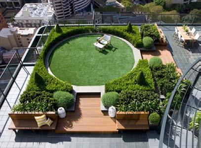
25 F. Menu of Public Gathering Place Types Table 5-5 Menu of Public Gathering Places Amphitheatre small Amphitheatre large Courtyard small commercial Courtyard large residential Outdoor dining small area Paseo. Building entry space Central green commercial Courtyard large commercial Employee break area Outdoor dining large area Plaza small. Central green residential Community garden Courtyard small residential On-site main street Parklet Plaza large Rooftop garden Folsom Boulevard Specific Plan 5-25
26 This page is intentionally left blank Folsom Boulevard Specific Plan
3.0 URBAN DESIGN. December 6, OVERVIEW
 Urban Design 3.0 URBAN DESIGN December 6, 2007 3.1 OVERVIEW The highly urban character of Easton Place is defined by the overall design of the community. The following sections provide an overview of the
DRAFT. 10% Common Open Space
 % OF CHARLOTTE IS CATEGORIZED AS A. LAND USES : Placeholder map displaying location of Place Type GOALS: Accommodate XX% of future growth. Provide a concentration of primarily commercial and civic activity
Town Center. Block 5 Existing multifamily residential units are expected to remain.
 Area Guidelines Germantown s districts should be developed as distinct communities with unique features that are supported through the guidelines. The guidelines not only help distinguish these districts
Policies and Code Intent Sections Related to Town Center
 Policies and Code Intent Sections Related to Town Center The Town Center Vision is scattered throughout the Comprehensive Plan, development code and the 1994 Town Center Plan. What follows are sections
4 C OMMUNITY D ISTRICTS
 4 C OMMUNITY D ISTRICTS N ew development in the Area will include many different types of land uses, including a destination retail area that attracts people from all over the region; recreation opportunities
Metro. Activity Center Design Guidelines. Recommendations For Developing Focused, Mixed-Use Commercial/Residential Centers
 Metro Activity Center Design Guidelines Recommendations For Developing Focused, Mixed-Use Commercial/Residential Centers Metro Activity Centers What is a MAC? Legacy, the adopted guide for the future growth
Table of Contents. Elm Avenue Improvement Plan City of Waco, Texas. Introduction 1. Existing Context 1 Figure 1 2.
 Table of Contents Introduction 1 Existing Context 1 Figure 1 2 Plan Guidelines 3 Future Urban Form 4 The West-End 4 Main Street 6 The East-End 7 Figure 2 9 Public Improvement Recommendations 7 General
FUTURE LAND USE ELEMENT
 FUTURE LAND USE ELEMENT GOAL I: To create and sustain a great place to live, play, and prosper Objective 1: The City of Ocala shall incorporate the principles and strategies of the Ocala 2035 Vision into
Lehigh Acres Land Development Regulations Community Planning Project
 Lehigh Acres Land Development Regulations Planning Effort Summary In July, 2010 Commissioner Frank Mann invited the Lehigh Acres community to start discussing how to achieve their recently adopted community
MIXED-USE VILLAGE OVERLAY FLOATING DISTRICT
 MIXED-USE VILLAGE OVERLAY FLOATING DISTRICT Zoning regulations developed by committee to the Planning Board for the Town of DeWitt, NY Issue date: 13 July 2017 revised 3/12/2018, revised 4/26/2018, 5/9/2018
5.1 Site Plan Guidelines
 5. Community Core Guidelines Development of the Community Core will take place by plan of subdivision and site plan approval. It will occur in a phased manner that will reflect the timing of residential
Town Center (part of the Comprehensive Plan)
") Town Center (part of the Comprehensive Plan) Mercer Island Town Center Looking North (2014) In 1994, a year-long process culminated in a set of design guidelines and code requirements for the Town Center
Town Center (part of the Comprehensive Plan) Mercer Island Town Center Looking North (2014) In 1994, a year-long process culminated in a set of design guidelines and code requirements for the Town Center
Seneca Meadows. Block 4 Locate office, technology, and medical development adjacent to I Screen views of garage structures from I-270.
 Seneca Meadows Seneca Meadows has an industrial park in its southern end and a mixed-use employment area planned for the north end. The district benefits from extensive I-270 visibility, stream valley
1.0 VISION STATEMENT. December 6, PRINCIPLES
 Vision Statement Lincoln Regional Airport 1.0 VISION STATEMENT 1.1 City LOCATION of AND OVERVIEW The Easton Lincoln Place Land Use Master Plan identifies the principles, goals, policies, and standards
Complete Neighbourhood Guidelines Review Tool
 Complete Neighbourhood Guidelines Review Tool Prepared By: City of Regina Planning Department October 2014 Page 1 of 14 Community Development Review Checklist for Secondary Plans and Concept Plans The
FLORIN ROAD CORRIDOR Site Plan and Design Review Guidelines Checklist
 FLORIN ROAD CORRIDOR Site Plan and Design Review Guidelines Checklist Applicant s Name: Project Address: Phone: Email: Applicant shall fill out the design guidelines checklist for all guidelines applicable
TRANSIT ORIENTED DEVELOPMENT PINELLAS COUNTY MPO LIVABLE COMMUNITIES INITIATIVE PINELLAS COUNTY COMPREHENSIVE PLAN AMENDMENTS
 PINELLAS COUNTY MPO LIVABLE COMMUNITIES INITIATIVE MODEL LAND DEVELOPMENT CODE TRANSIT ORIENTED DEVELOPMENT PINELLAS COUNTY COMPREHENSIVE PLAN AMENDMENTS MPO Livable Communities Initiative Goal: Improve
SPRINGHILL LAKE TRANSIT VILLAGE
 Greenbelt Metro Area Sector Plan - Subarea Design Policies and Guidelines - Springhill Lake Transit Village 113 SPRINGHILL LAKE TRANSIT VILLAGE Residential Neighborhood and Village Center CONCEPT Springhill
Chapter 6--Urban Design
 6.1 Introduction... 6-1 6.1.1 Background & Scope... 6-1 6.1.2 Relationship to State Law... 6-2 6.1.3 Relationship to Other General Plan Chapters... 6-2 6.2 Guiding Principles... 6-2 6.3 Urban Design Guidelines...
ELMVALE ACRES SHOPPING CENTRE MASTER PLAN
 ELMVALE ACRES SHOPPING CENTRE MASTER PLAN Contents 1.0 INTRODUCTION... 2 2.0 LOCATION... 2 3.0 EXISTING CONTEXT... 2 4.0 VISION & GUIDING PRINCIPLES... 2 5.0 LAND USE AND BUILT FORM... 4 5.1 St. Laurent
Planning Board Briefing
 Planning Board Briefing Why Now? The Sector Plan Implementation Chapter States: Before Stage 1 begins, the following must occur: Approval of the Sectional Map Amendment. Approval of the Greater Lyttonsville
The Village. Chapter 3. Mixed Use Development Plan SPECIFIC PLAN
 The Village SPECIFIC PLAN Chapter 3 3.1 INTRODUCTION 3.1.1 Purpose This Chapter describes the development regulations applicable to the Mixed-Use and Transit Center Planning Areas. These form-based regulations
Neighborhood Districts
 NEIGHBORHOOD DISTRICTS SEVEN MAIN DISTRICTS Neighborhood Districts While the Development Plan provides a broad-scale overview of the neighborhood, this section focuses on uses and relationships at the
VILLAGE OF SKOKIE Design Guidelines for Mixed-Use Districts NX Neighborhood Mixed-Use TX Transit Mixed-Use CX Core Mixed-Use
 VILLAGE OF SKOKIE Design Guidelines for Mixed-Use Districts NX Neighborhood Mixed-Use TX Transit Mixed-Use CX Core Mixed-Use TABLE OF CONTENTS CHAPTER 1 SITE DESIGN Purpose 1 CHAPTER 2 SITE DESIGN Streetscape
URBAN DESIGN BRIEF URBAN DESIGN BRIEF 721 FRANKLIN BLVD, CAMBRIDGE August 2018
 URBAN DESIGN BRIEF URBAN DESIGN BRIEF 721 FRANKLIN BLVD, CAMBRIDGE August 2018 DESIGN BRIEF CONTENTS PART A 1.0 INTRODUCTION 2.0 DESCRIPTION & ANALYSIS OF SITE CONTEXT 3.0 DESIGN CONSTRAINTS AND OPPORTUNITIES
THEMES, VISION, + PRINCIPLES
 CHAPTER 2: THEMES, VISION, + PRINCIPLES This page intentionally left blank. 20 VISION DRAFT AUGUST 2018 2 2 THEMES, VISION, + GUIDING PRINCIPLES The Key Themes, Vision, and Guiding Principles presented
4.0 Design Guidelines For The Village Centre. South fields Community Architectural Design Guidelines Town of Caledon
 4.0 Design Guidelines For The Village Centre 4.0 Design Guidelines for the Village Centre The Village Centre is the focal point of the entire South Fields Community and is designed as a traditional commercial
City of Farmington. Downtown Plan. Amendment to the 1998 Master Plan Adopted October 11, 2004
 City of Farmington Amendment to the 1998 Master Plan Adopted October 11, 2004 Introduction Planning Background 1 Scope and Components of the Plan Amendment 2 Concept Introduction 3 Plan Concepts 3 Conceptual
WEST LOOP DESIGN GUIDELINES CHECKLIST
 WEST LOOP DESIGN GUIDELINES CHECKLIST Section 1.0 General Strategies 1.1 DESIGN EXCELLENCE: ENCOURAGE HIGH QUALITY AND INNOVATIVE DESIGN OF NEW BUILDINGS WITHIN THE WEST LOOP WITHOUT BEING PRESCRIPTIVE
Millbrae TOD #2 Project Analysis
 Millbrae TOD #2 Project Analysis Project Description A Site Development Permit and Conditional Use Permit are proposed to allow for a mixed-use transitoriented development on approximately 9 Acres located
SUBCHAPTER 4-B GUIDELINES FOR THE B-3 COMMERCIAL CHARACTER AREA
 1 SUBCHAPTER 4-B GUIDELINES FOR THE B-3 COMMERCIAL CHARACTER AREA Downtown Bozeman should be the location of buildings of greatest height and intensity in the community. The following guidelines apply
2.0 THE PLATINUM TRIANGLE VISION
 2.0 THE PLATINUM TRIANGLE VISION The envisions an exciting future for the area surrounding Angel Stadium of Anaheim, the Honda Center and The Grove of Anaheim. 2.1 Planning Principles In order to further
PUBLIC RIGHT-OF-WAY IN THIS CHAPTER PUBLIC REALM
 PUBLIC RIGHT-OF-WAY This section provides design guidelines for improvements in the public right-of-way. The public right-of-way refers to streets, sidewalks, non-vehicular thoroughfares, parks and greenways
lot flankage Y street 16m 6m landscape strip for large site 3m landscape strip for small medium site
 Commercial General Commercial Objectives Create developments compatible with adjacent land uses in scale, function and character Define a consistent and attractive street edge with quality landscaping,
for Master Planned Development Framework Design Standards & Guidelines
 B L A C K D I A M O N D DE S I G N G U I D E L I N E S for Master Planned Development Framework Design Standards & Adopted June 18, 2009 Introduction and Purpose The Master Planned Development (MPD) Framework
Section 9 NEIGHBORHOOD DESIGN
 Section 9 NEIGHBORHOOD DESIGN City of Lancaster Comprehensive Plan D u n k i n, S e f k o & A s s o c i a t e s, I n c. NEIGHBORHOOD DESIGN INTRODUCTION There are many ways in which a neighborhood can
The University District envisions, in its neighborhood
 Envisioning the University District Link Light Rail in Seattle s neighborhoods CIY OF SEALE CONCEP-LEVEL SAION AREA PLANNING RECOMMENDAION RESOLUION # 30165 EXHIBI L Vision 08.2000 he University District
4.9 Mendocino Avenue Corridor Plan Design Guidelines
 4.9 Mendocino Avenue Corridor Plan Design Guidelines The Mendocino Avenue Corridor Plan addresses the area between College Avenue and Steele Lane. Mendocino Avenue is a busy arterial that runs parallel
CHAPTER 3 VISION, GOALS, & PLANNING PRINCIPLES. City of Greensburg Comprehensive Plan. Introduction. Vision Statement. Growth Management Goals.
 CHAPTER 3 VISION, GOALS, & PLANNING PRINCIPLES Introduction The Greensburg Comprehensive Plan is intended as a working community document. A combination of long and short-term goals, this document is intended
Clairtrell Area Context Plan
 Clairtrell Area Context Plan March 2005 Urban Development Services City Planning Contents 1. Introduction... 4 2. Development Structure... 6 2.1 Streets... 7 2.1.1 Sheppard Avenue and Bayview Avenue...
North Downtown Specific Plan MEMORANDUM
 North Downtown Specific Plan MEMORANDUM MEETING DATE: November 13, 2017 TO: Members of the North Downtown Specific Plan Advisory Committee FROM: Jeanine Cavalli, Senior Planner SUBJECT: Materials for the
Pedestrian and Bike Bridge LOGO
 6.2.2 Pedestrian and Bike Bridge The proposed pedestrian and bike crossing re-envisions the existing bridge at Pismo Creek on Cypress Street. The bridge is currently underutilized by vehicular through
appendix and street interface guidelines
 appendix five: building and street interface guidelines appendix 5 building and street interface guidelines BOULEVARDS Boulevards are generally characterized by higher levels of traffic movement at higher
Regency Developments. Urban Design Brief. Holyrood DC2 Rezoning
 Regency Developments Urban Design Brief Holyrood DC2 Rezoning Stantec Consulting Ltd. 7-31-2017 1. Overview Regency Developments intends to rezone the lands located at 8510 and 8511 93 Avenue, within the
FRUITVALE TRANSIT VILLAGE (Phase 2) Residential Project
 Residential Project") FRUITVALE TRANSIT VILLAGE (Phase 2) Residential Project DEVELOPER: SIGNATURE PROPERTIES ARCHITECT: HKIT ARCHITECTS April 23, 2010 TABLE OF CONTENTS 3 Vision 4 Description of Site 5 Guiding Concepts 6
FRUITVALE TRANSIT VILLAGE (Phase 2) Residential Project DEVELOPER: SIGNATURE PROPERTIES ARCHITECT: HKIT ARCHITECTS April 23, 2010 TABLE OF CONTENTS 3 Vision 4 Description of Site 5 Guiding Concepts 6
II. SINGLE FAMILY RESIDENTIAL
 II. SINGLE FAMILY RESIDENTIAL Castle Rock is made up of numerous individually built houses and subdivision tracts that have been developed during the past century. Some of the tracts are diverse in architectural
RESIDENTIAL DISTRICTS
 RESIDENTIAL DISTRICTS The residential district standards have been revised to reflect on-the-ground conditions, while continuing to respect the use patterns established within the neighborhoods. This will
Today Land & People. Northeast Nampa Gateway District. Employment. Land Use Characteristics. Demographics. Current Zoning
 Today Land & People Employment Major employers include Saint Alphonsus, the College of Western Idaho, the Auto Mall, Sorrento Lactalis and Walmart. 3,004 jobs in 2010 (COMPASS-CIM 2040 TAZ data) 4,345
17.11 Establishment of Land Use Districts
 17.11 Establishment of Land Use Districts 17.11.010 Purpose. To promote the health, safety, and general welfare of City residents and those who come to South Salt Lake to work, exchange commerce and recreate.
(DC1) Direct Development Control Provision DC1 Area 4
 Direct Development Control Provision DC1 Area 4") . General Purpose (DC) Direct Development Control Provision DC Area 4 The purpose of this Provision is to provide for an area of commercial office employment and residential development in support of the
. General Purpose (DC) Direct Development Control Provision DC Area 4 The purpose of this Provision is to provide for an area of commercial office employment and residential development in support of the
Buildings may be set back to create small plazas provided that these setbacks do not substantially disrupt the street wall s continuity.
 6-22 Community Design Street Walls and Street-front Setbacks The siting of buildings will play a critical role in establishing the character and sense of place for the District. Siting buildings at the
Small Area Plan. South Gateway
 Small Area Plan Adopted May 12, 2008 South Gateway Purpose. The South Gateway Small Area Plan defines the City s expectations for the future of the southern entrance to the City at Interstate 85 and Highway
ARTICLE 13 STREETS General
 ARTICLE 13 STREETS 13.1 General Streets shall be designed to suit their functions. Many streets have purposes other than vehicular traffic. As an alternative to current N.C. Department of Transportation
Harmony Technology Park Third Filing, Second Replat Custom Blending, Project Development Plan/Final Development Plan - FDP #130021
 ITEM NO FDP #130021 MEETING DATE July 23, 2013 STAFF Pete Wray ADMINISTRATIVE TYPE I HEARING STAFF REPORT PROJECT: APPLICANT: OWNER: Harmony Technology Park Third Filing, Second Replat Custom Blending,
SECTION TWO: Urban Design Concepts
 SECTION TWO: Urban Design Concepts The Gardnerville Plan for Prosperity shapes economic opportunities presented by regional growth. The Urban Design Concepts provide policies and concepts for land use,
6. DOWNTOWN. The Downtown Element focuses on supporting and expanding the vitality and enhancement of Downtown Chico as the City s central core.
 VISION In 2030, Downtown Chico is the heart of the community and the center of cultural activity. Engaging and active at the street level, it is a multi-story, mixed-use hub, with specialty retail, restaurants,
Corridor Planning Area
 Corridor Planning Area PLANNING AREA DESCRIPTION Planning Area Boundaries The Corridor planning area generally includes the areas of the Village south of Belleview Avenue, west of Yosemite Street, north
3.1 community vision. 3.3 required plan elements
 Chapter 3 Community Form 3.1 community vision 3.2 Parks & landscaping concepts 3.3 required plan elements D R A F T 20 Community Form Chapter 3 3.0 Community form 3.1 community vision The Specific Plan
PROPOSED WATERFRONT DISTRICT DESIGN STANDARDS
 PROPOSED WATERFRONT DISTRICT DESIGN STANDARDS 20.25 DESIGN REVIEW. 20.25.080 WATERFRONT DISTRICT A. Purpose. This section is intended to implement The Waterfront District Subarea Plan by: 1. Creating a
Highland Village Green Design Guidelines
 Highland Village Green Design Guidelines Publishing Information Title Highland Village Green Design Guidelins Author The City of Calgary Status DRAFT - Proposed document subject to changes Additional Copies
Study Area. Capitol Way. Greening America s Capitals 11/13/2014. A Greening America s Capitals Project
 Olympia, WA: Greening Capitol Way Supporting Communities move towards sustainability is a priority for the federal government. A Greening America s Capitals Project Office of Sustainable Communities U.S.
INSTITUTIONAL USE DESIGN COMPATIBILITY TECHNIQUES
 INSTITUTIONAL USE DESIGN COMPATIBILITY TECHNIQUES INTRODUCTION Community institutions are an important part of the character and vitality of neighborhoods in Forsyth County. Institutional uses include
Cit of Kitchener Ur 6 an Design Manual PARTA. Desi n for _--::
 Cit of Kitchener Ur 6 an Design Manual Date PARTA Year ) Desi n for k Nodes Corridors _--:: Section Page 01 of 12 2 INTRODUCTION Purpose & Application Nodes and Corridors have been identified as key intensification
EXISTING COMPREHENSIVE PLAN
 EXISTING COMPREHENSIVE PLAN Town Center Land Use Element: V. LAND USE POLICIES Town Center Mercer Island's business district vision as described in "Your Mercer Island Citizen-Designed Downtown" was an
SYRINGA VALLEY SPECIFIC PLAN NARRATIVE
 SYRINGA VALLEY SPECIFIC PLAN NARRATIVE Introduction With this application, Pleasant Valley South LLC ( Pleasant Valley ) seeks the City of Boise s approval of a new Specific Plan Ordinance to be added
B L A C K D I A M O N D D E S I G N G U I D E L I N E S for Multi-family Development
 B L A C K D I A M O N D D E S I G N G U I D E L I N E S for Multi-family Development Adopted June 18, 2009 This section of the Design and focuses on site planning and design guidance for new multi-family
CHAPTER 4 - LAND USE CLASSIFICATIONS
 CHAPTER 4 - LAND USE CLASSIFICATIONS Four new land use classification categories are established in the Gualala Town Plan: Gualala Village Mixed Use; Gualala Highway Mixed Use; Gualala Planned Development
Additional information about land use types is given in Chapter 5. Design guidelines for Centers and Neighborhoods are given in Chapter 7.
 4. Place Types Introduction In Albemarle County s Development Areas, the Neighborhood is the fundamental unit of community planning. The County s Neighborhood Model, an adopted part of the Comprehensive
Standards (R-3) Figure B-11: R-3 Residential Standards Exhibit
 Figure B-11: R-3 Residential Standards Exhibit") Avila Ranch Avila Ranch Specific Plan Development Standards High Medium Density - High Residential Density Residential Lot and Building Lot and Standards Building (R-3) Standards (R-3) EXAMPLES These sketches
Avila Ranch Avila Ranch Specific Plan Development Standards High Medium Density - High Residential Density Residential Lot and Building Lot and Standards Building (R-3) Standards (R-3) EXAMPLES These sketches
RESEDA - WEST VAN NUYS COMMUNITY PLAN
 RESEDA - WEST VAN NUYS COMMUNITY PLAN Executive Summary As part of the initial outreach effort, the Department of City Planning hosted two workshops for the Reseda-West Van Nuys Community Plan Area during
DRAFT Northeast Quadrant of Kipling Avenue and Highway 7 DRAFT AUGUST 29, Goals Land Use. The goals of this Plan are to:
 AUGUST 29, 2017 12.15 Northeast Quadrant of Kipling Avenue and Highway 7 12.15.1 Goals 12.15.2 Land Use The goals of this Plan are to: 12.15.2.1 General Provisions: a) Ensure the development of a compact
4.1.3 LAND USE CATEGORIES
 4.1.3 LAND USE CATEGORIES a. City Center District The City Center District incorporates the existing character and mix of uses in downtown Belmont to encourage redevelopment and new development in keeping
Urban Design Manual PLANNING AROUND RAPID TRANSIT STATIONS (PARTS) Introduction. Station Study Areas
 Introduction. Station Study Areas") 111111 PLANNING AROUND RAPID TRANSIT STATIONS (PARTS) Introduction The ION rapid transit system will link Waterloo, Kitchener and Cambridge through a central transit corridor (CTC). There are a number
111111 PLANNING AROUND RAPID TRANSIT STATIONS (PARTS) Introduction The ION rapid transit system will link Waterloo, Kitchener and Cambridge through a central transit corridor (CTC). There are a number
Mark-up of the effect of the proposed Bronte Village Growth Area OPA No.18 on the text of section 24, Bronte Village, of the Livable Oakville Plan
 Mark-up of the effect of the proposed Bronte Village Growth Area OPA No.18 on the text of section 24, Bronte Village, of the Livable Oakville Plan Notes: This document is provided for information purposes
The transportation system in a community is an
 7 TRANSPORTATION The transportation system in a community is an important factor contributing to the quality of life of the residents. Without a sound transportation system to bring both goods and patrons
ATTACHMENT A. SILVERDALE DESIGN STANDARDS Amendments to the Waaga Way Town Center Chapter
 ATTACHMENT A SILVERDALE DESIGN STANDARDS Amendments to the Waaga Way Town Center Chapter Chapter 10. Waaga Way Town Center 10.1 Physical Identity Elements & Opportunities The Waaga Way Town Center includes
ARTICLE 13 STREETS General
 ARTICLE 13 STREETS 13.1 General Streets shall be designed to suit their functions. Many streets have purposes other than vehicular traffic. As an alternative to current N.C. Department of Transportation
C. Westerly Creek Village & The Montview Corridor
 C. Westerly Creek Village & The VISION Community Vision When the goals of the city are achieved Westerly Creek Village, a distinctive community defined by Montview Boulevard and Westerly Creek, is a strong
GUIDELINES. Transit Oriented Development. Approved by Edmonton City Council on February 15, 2012 in tandem with City Policy C565
 Transit Oriented Development GUIDELINES Prepared by the City of Edmonton Sustainable Development and Transportation Services Departments Approved by Edmonton City Council on February 15, 2012 in tandem
Introduction Plan Overview Performance and Development Standards Design Guidelines
 TABLE OF CONTENTS Introduction... 6-11 Plan Overview... 6-19 Performance and Development Standards... 6-27 Design Guidelines... 6-33 6-9 6-10 This page is intentionally left blank. 6-11 INTRODUCTION This
Zoning Code Issues Prioritization
 City of Streetsboro The City of Streetsboro has begun the process of updating its Zoning Code. The new Zoning Code will be based on the recently adopted Comprehensive Plan, which establishes the overall
Citizen Advisory Group Meeting 5: Land Use April 14, 2011
 Citizen Advisory Group Meeting 5: Land Use April 14, 2011 Meeting Agenda 1. Background Review 2. Transportation Follow-up 3. PED Overlay Approach 4. Land Use Mapping 5. Group Exercise 6. Wrap-up and Next
WATERFRONT DISTRICT DESIGN STANDARDS
 WATERFRONT DISTRICT DESIGN STANDARDS 20.25.080 WATERFRONT DISTRICT A. Purpose. This section is intended to implement The Waterfront District Subarea Plan by: 1. Creating a safe, vibrant mixed-use urban
Glenborough at Easton Land Use Master Plan
 Vision Statement Sunrise Blvd. Hazel Ave. Prairie City Rd. Gencorp Property Lincoln Regional Airport 1.0 VISION STATEMENT The identifies City of the principles, goals, policies, and standards Lincoln that
Sahuarita District & Phase 1 Master Plan. Town Council December 11, 2017
 Sahuarita District & Phase 1 Master Plan Town Council December 11, 2017 Visioning Study Visioning Process Advisory Group Meetings Community Questionnaire Town Center Case Studies Community Analysis The
TRANSIT NEIGHBORHOOD PLANS PROGRAM OVERVIEW
 TRANSIT NEIGHBORHOOD PLANS PROGRAM OVERVIEW OCTOBER 2017 Los Angeles Department of City Planning @LATNP and @Planning4LA Outline Introduction Policy Framework The Transit Neighborhood Plans Program Overview:
Wide asphalt driveway abutting school property. garage built with incompatible materials, too close to park. incompatible fencing materials
 Wide asphalt driveway abutting school property incompatible fencing materials garage built with incompatible materials, too close to park Lack of plantings as a buffer between private property and open
ALBEMARLE COUNTY CODE CHAPTER 18 ZONING SECTION 20A NEIGHBORHOOD MODEL - NMD
 CHAPTER 18 ZONING SECTION 20A NEIGHBORHOOD MODEL - NMD Sections: 20A.1 PURPOSE AND INTENT 20A.2 STATUS AS A PLANNED DEVELOPMENT DISTRICT 20A.5 CODES OF DEVELOPMENT 20A.6 PERMITTED USES 20A.7 RESIDENTIAL
LAND USE OVERVIEW WHAT YOU WILL FIND IN THIS CHAPTER
 LAND USE WHAT YOU WILL FIND IN THIS CHAPTER Information about the City s expected population and employment growth. Description and capacity of existing and future land use designations. Policies that
Be it enacted by the Town Board of the Town of Guilderland that the following new A (Transit Oriented Development (TOD) District) is adopted:
 District) is adopted:") Local Law No. 4 of 2018 (Adoption of 280-18A (Transit Oriented Development District) Be it enacted by the Town Board of the Town of Guilderland that the following new 280-18A (Transit Oriented Development
Local Law No. 4 of 2018 (Adoption of 280-18A (Transit Oriented Development District) Be it enacted by the Town Board of the Town of Guilderland that the following new 280-18A (Transit Oriented Development
Cleveland Park Streetscape and Drainage Improvement Project 1
 Cleveland Park Streetscape and Drainage Improvement Project 1 Urban Context Washington, D.C. Connecticut Avenue Cleveland Park Streetscape and Drainage Improvement Project 2 Neighborhood Context Contributing
Site Planning. 1.0 Site Context. 2.0 Pedestrian Circulation Systems. Pag e 2-23
 The following photographs from throughout the country illustrate key urban design principles. Photographs are provided to illustrate the overall urban design concepts described in Chapter 1 of the Downtown
Chapter 4. Linking Land Use with Transportation. Chapter 4
 Chapter 4 Linking Land Use with Transportation Chapter 4 59 Chapter 4 Linking Land Use with Transportation Community Design and Transportation Program Introduction Since the 1950s, the predominant development
Tyvola & Archdale Transit Station Area Plan. June 5, 2008
 Tyvola & Archdale Transit Station Area Plan Second Public Meeting June 5, 2008 Presentation Outline 1. Purpose and Process 2. Station Area Overview 3. Plan Recommendations 4. Comments Received and Proposed
Chapter PEDESTRIAN COMMERCIAL (PC) ZONING DISTRICT
 ZONING DISTRICT") Chapter 11-17 PEDESTRIAN COMMERCIAL (PC) ZONING DISTRICT Sections: 11-17-01 GENERAL PURPOSE 11-17-02 PERMITTED BUILDING TYPES 11-17-03 USES PERMITTED WITH DESIGN REVIEW 11-17-04 USES PERMITTED BY CONDITIONAL
Chapter 11-17 PEDESTRIAN COMMERCIAL (PC) ZONING DISTRICT Sections: 11-17-01 GENERAL PURPOSE 11-17-02 PERMITTED BUILDING TYPES 11-17-03 USES PERMITTED WITH DESIGN REVIEW 11-17-04 USES PERMITTED BY CONDITIONAL
Design Guidelines. Roosevelt. Mike Podowski DPD Design Guidelines Ordinance ATT 13 August 13, 2012 Version #1
 Roosevelt Design Guidelines The Roosevelt Neighborhood Design Guidelines apply within the Neighborhood Boundary. Map 1 2 Map 2 3 Map 3 4 CS1 Natural Systems and Site Features Citywide Guideline: Use natural
(Note: bold typing indicates sections that have been added or modified from the currently adopted Design Guidelines.)
") Draft July 31, 2014 3.0 Multifamily (Note: bold typing indicates sections that have been added or modified from the currently adopted.) The purpose of this chapter is to provide planning and design guidelines
Draft July 31, 2014 3.0 Multifamily (Note: bold typing indicates sections that have been added or modified from the currently adopted.) The purpose of this chapter is to provide planning and design guidelines
MULTIFAMILY RESIDENTIAL DESIGN PRINCIPLES Site Plan and Design Review Principles Checklist
 MULTIFAMILY RESIDENTIAL DESIGN PRINCIPLES Site Plan and Design Review Principles Checklist Applicant s Name: Project Address: Phone: Email: Applicant shall fill out the design guidelines checklist for
Gold Line Bus Rapid Transit Transit Oriented Development (BRTOD) Helmo Station Area Plan
 Helmo Station Area Plan") Appendix F Gold Line Bus Rapid Transit Transit Oriented Development (BRTOD) Helmo Station Area Plan Introduction and Purpose of the Plan The Gold Line Bus Rapid Transit facility is an eleven-mile dedicated
Appendix F Gold Line Bus Rapid Transit Transit Oriented Development (BRTOD) Helmo Station Area Plan Introduction and Purpose of the Plan The Gold Line Bus Rapid Transit facility is an eleven-mile dedicated
CHAPTER 3. Design Standards for Business, Commercial, Industrial, Recreational and Institutional Uses
 CHAPTER 3 Design Standards for Business, Commercial, Section Number Title Ordinance Number Date of Ordinance 16-3-1 Applicability 2006-11 2008-04 07-01-08 16-3-2 Uniform Standards for Architectural Design