THE PRESERVE AT ISLAND LAKE (PHASE 8) JSP13-69
|
|
|
- Hugo King
- 5 years ago
- Views:
Transcription
 Agreement and Plan and for")
1 THE PRESERVE AT ISLAND LAKE (PHASE 8) JSP13-69 THE PRESERVE AT ISLAND LAKE (PHASE 8) JSP13-69 Public hearing at the request of Toll Brothers, Inc. for recommendation to City Council for approval to include the subject property in the existing Island Lake of Novi by amending the Residential Unit Development (RUD) Agreement and Plan and for Preliminary Site Plan, Woodland Permit and Stormwater Management Plan approval. The subject property is acres in Section 19 of the City of Novi and located at the northeast corner of Ten Mile Road and Napier Road. The applicant is proposing a 45 unit development that would be Phase 8 of the existing Island Lake of Novi development. The applicant has also proposed to modify the number of units permitted in the RUD Agreement from 884 to 903 in order to allow for this development. Required Action Recommend approval/denial of the amended Residential Unit Development (RUD) Agreement and Plan to the City Council and approval/denial of the Preliminary Site Plan, Wetland Permit, Woodland Permit and Stormwater Management Plan. REVIEW RESULT DATE COMMENTS Planning Engineering Traffic Landscaping Wetland Woodland Fire Approval recommended Approval recommended Approval recommended Approval recommended Approval recommended Approval recommended Approval recommended City Council modification of lot size and width requested City Council variances of location of pathways and sidewalks requested, direction from Planning Commission requested by staff Items to be addressed on the Final Site Plan submittal Items to be addressed on the Final Site Plan submittal City Council variance of local street width standard for traffic calming chokers requested Items to be addressed on the Final Site Plan submittal Planning Commission waiver for the discontinuation of berms in the locations of existing vegetation and wetlands requested, with the exception of lots 1, 2 and 45 Items to be addressed on the Final Site Plan submittal Items to be addressed on the Final Site Plan submittal Items to be addressed on the Final Site Plan submittal No items need to be addressed
2 Motion Sheet Approval Amended RUD In the matter of The Preserve at Island Lake (Phase 8), JSP13-69, motion to recommend approval of the Amended Residential Unit Development (RUD) Agreement and Plan subject to and based on the following findings: a. The site is appropriate for the proposed use; b. The development will not have detrimental effects on adjacent properties and the community; c. The applicant has clearly demonstrated a need for the proposed use; d. Care has been taken to maintain the naturalness of the site and to blend the use within the site and its surroundings; e. The applicant has provided clear, explicit, substantial and ascertainable benefits to the City as a result of the Amended RUD. f. Relative to other feasible uses of the site: 1. All applicable provisions of Section 2402 of the Zoning Ordinance, other applicable requirements of the Zoning Ordinance, including those applicable to special land uses, and all applicable ordinances, codes, regulations and laws have been met; 2. Adequate areas have been set aside for all schools, walkways, playgrounds, parks, recreation areas, parking areas and other open spaces and areas to be used by residents of the development; 3. Traffic circulation features within the site and the location of parking areas have been designed to assure the safety and convenience of both vehicular and pedestrian traffic both within the site and in relation to access streets; 4. The proposed use will not cause any detrimental impact in existing thoroughfares in terms of overall volumes, capacity, safety, travel times and thoroughfare level of service; 5. The plan provides adequate means of disposing of sanitary sewage, disposing of stormwater drainage, and supplying the development with water; 6. The Amended RUD will provide for the preservation and creation of open space and result in minimal impacts to provided open space and natural features; 7. The Amended RUD will be compatible with adjacent and neighboring land uses; 8. The desirability of conventional residential development within the City is outweighed by benefits occurring from the preservation and creation of open space and the establishment of school and park facilities that will result from the Amended RUD; 9. Any detrimental impact from the Amended RUD resulting from an increase in total dwelling units over that which would occur with conventional residential development is outweighed by benefits occurring from the preservation and creation of open space and the establishment of school and park facilities that will result from the Amended RUD; 10. The proposed reductions in lot sizes are the minimum necessary to preserve and create open space, to provide for school and park sites, and to ensure compatibility with adjacent and neighboring land uses; 11. The Amended RUD will not have a detrimental impact on the City's ability to deliver and provide public infrastructure and public services at a reasonable cost; 12. the applicant has made satisfactory provisions for the financing of the installation of all streets, necessary utilities and other proposed improvements;
3 13. The applicant has made satisfactory provisions for future ownership and maintenance of all common areas within the proposed development; and 14. Proposed deviations from the area, bulk, yard, and other dimensional requirements of the Zoning Ordinance applicable to the property enhance the development, are in the public interest, are consistent with the surrounding area, and are not injurious to the natural features and resources of the property and surrounding area. g. City Council modification of proposed lot sizes to a minimum of 14,440 square feet and modification of proposed lot widths to a minimum of feet as the requested modification will result in the preservation of open space for those purposes noted in Section B of the Zoning Ordinance and the Amended RUD will provide a genuine variety of lot sizes; h. City Council variance from Section 11 Table 8-A of the City s Code of Ordinance to permit a local street reduction from 28 feet in width to 20 feet in width for traffic calming chokers as depicted in the proposed plans. i. City Council variance from Section (b)(5) of the City s Code of Ordinance to permit a sidewalk along Ten Mile Road to vary more than 1 foot from the rightof-way in order to protect natural resources while still maintaining a comprehensive non-motorized transportation system as depicted in the proposed plans. j. Planning Commission to recommend one of the following: 1. City Council variance from Section (d) of the City s Code of Ordinance to permit a bicycle path along Napier Road to vary more than 1 foot from the right-of-way in order to protect natural resources while still maintaining a comprehensive non-motorized transportation system as depicted as Option B in the proposed plans. (APPLICANT S PREFERENCE) -OR- 2. City Council variance from Section (d) of the City s Code of Ordinance to permit a bicycle path along the northern portion of Napier Road only to vary more than 1 foot from the right-of-way in order to protect natural resources while still maintaining a comprehensive non-motorized transportation system as depicted as Option A in the proposed plans. (STAFF RECOMMENDATION) k. (additional comments here if any) (because the plan is otherwise in compliance with Article 3, Article 24 and Article 25 of the Zoning Ordinance and all other applicable provisions of the Ordinance.) Approval Preliminary Site Plan In the matter of The Preserve at Island Lake (Phase 8), JSP13-69, motion to approve the Preliminary Site Plan based on and subject to approval by City Council of the amended RUD Agreement and Plan and the following: a. Planning Commission waiver of the required berms in the locations of existing vegetation and wetlands with the exception of lots 1, 2 and 45; which is hereby granted; b. The conditions and items listed in the staff and consultant review letters being addressed on the Final Site Plan; and c. (additional conditions here if any) (This motion is made because the plan is otherwise in compliance with the approved 6 th Amendment to the RUD, Article 3, Article 24 and Article 25 of the Zoning Ordinance and
4 all other applicable provisions of the Ordinance.) Approval Wetland Permit In the matter of The Preserve at Island Lake (Phase 8), JSP13-69, motion to approve the Wetland Permit based on and subject to approval by City Council of the amended RUD Agreement and Plan and the following: a. The findings of compliance with Ordinance standards in the staff and consultant review letters, and the conditions and items listed in those letters being addressed on the Final Site Plan; and b. (additional conditions here if any) (This motion is made because the plan is otherwise in compliance with Chapter 12, Article V of the Code of Ordinances and all other applicable provisions of the Ordinance.) Approval Woodland Permit In the matter of The Preserve at Island Lake (Phase 8), JSP13-69, motion to approve the Woodland Permit based on and subject to approval by City Council of the amended RUD Agreement and Plan and the following: a. The conditions and items listed in the staff and consultant review letters being addressed on the Final Site Plan; and b. (additional conditions here if any) (This motion is made because the plan is otherwise in compliance with the approved 6 th Amendment to the RUD, Chapter 37 of the Code of Ordinances and all other applicable provisions of the Ordinance.) Approval Stormwater Management Plan In the matter of The Preserve at Island Lake (Phase 8), JSP13-69, motion to approve the Stormwater Management Plan, based on and subject to approval by City Council of the amended RUD Agreement and Plan and the following: a. The conditions and items listed in the staff and consultant review letters being addressed on the Final Site Plan; and b. (additional conditions here if any) (This motion is made because it otherwise in compliance with the approved 6 th Amendment to the RUD, Chapter 11 of the Code of Ordinances and all other applicable provisions of the Ordinance.)
5 -OR- Denial Amended RUD In the matter of The Preserve at Island Lake (Phase 8), JSP13-69, motion to recommend denial of the Amended Residential Unit Development Agreement (because the proposed Amended RUD would not satisfy the findings and conditions noted in Sections , , A and B of the Zoning Ordinance.) Denial Preliminary Site Plan In the matter of The Preserve at Island Lake (Phase 8), JSP13-69, motion to deny the Preliminary Site Plan (because the plan is not in compliance with the approved 6 th Amendment to the RUD, Article 3, Article 24 and Article 25 of the Zoning Ordinance and all other applicable provisions of the Ordinance.) Denial Wetland Permit In the matter of The Preserve at Island Lake (Phase 8), JSP13-69, motion to deny the Wetland Permit (because the plan is not in compliance with the approved 6 th Amendment to the RUD, Chapter 12, Article V of the Code of Ordinances and all other applicable provisions of the Ordinance.) Denial Woodland Permit In the matter of The Preserve at Island Lake (Phase 8), JSP13-69, motion to deny the Woodland Permit (because the plan is not in compliance with the approved 6 th Amendment to the RUD, Chapter 37 of the Code of Ordinances and all other applicable provisions of the Ordinance.) Denial Stormwater Management Plan In the matter of The Preserve at Island Lake (Phase 8), JSP13-69, motion to deny the Stormwater Management Plan (because the plan is not in compliance with the 6 th Amendment to the RUD, Chapter 11 of the Code of Ordinances and all other applicable provisions of the Ordinance.)
6 MAPS Location Zoning Future Land Use Natural Features
7 JSP13-69 Preserve at Island Lake (Phase 8) Hadlock Dr Location Map Legend Subject Property Chesapeake Dr Napier Rd Nepavine Dr Amesburg Terra Del Mar Drakes Bay Dr Calvert Isle Dr Dr Dr Subject Property Kennebee Dr Bill enca Dr Bellingham Dr Langley Dr Ten Mile Rd Feet ,020 ay br 1 inch = 630 feet Map Author: Sara Roediger Date: I City of Novi Planning Division Community Development Dept W Ten Mile Rd Novi, MI cityofnovi.org MAP INTERPRETATION NOTICE Map information depicted is not intended to replace or substitute for any official or primary source. This map was intended to meet National Map Accuracy Standards and use the most recent, accurate sources available to the people of the City of Novi. Boundary measurements and area calculations are approximate and should not be construed as survey measurements performed by a licensed Michigan Surveyor as defined in Michigan Public Act 132 of 1970 as amended. Please contact the City GIS Manager to confirm source and accuracy information related to this map.
8 JSP13-69 Preserve at Island Lake (Phase 8) Hadlock Dr Zoning Map Legend Subject Property R-A: Residential Acreage R-1: One-Family Residential Chesapeake Dr Napier Rd Nepavine Dr Amesburg Terra Del Mar Drakes Bay Dr Calvert Isle Dr Dr Dr Subject Property Kennebee Dr Bill enca Dr Bellingham Dr Langley Dr Ten Mile Rd Feet ,020 ay br 1 inch = 630 feet Map Author: Sara Roediger Date: I City of Novi Planning Division Community Development Dept W Ten Mile Rd Novi, MI cityofnovi.org MAP INTERPRETATION NOTICE Map information depicted is not intended to replace or substitute for any official or primary source. This map was intended to meet National Map Accuracy Standards and use the most recent, accurate sources available to the people of the City of Novi. Boundary measurements and area calculations are approximate and should not be construed as survey measurements performed by a licensed Michigan Surveyor as defined in Michigan Public Act 132 of 1970 as amended. Please contact the City GIS Manager to confirm source and accuracy information related to this map.
9 JSP13-69 Preserve at Island Lake (Phase 8) Hadlock Dr Future Land Use Map Legend Subject Property Single Family Private Park Chesapeake Dr Napier Rd Nepavine Dr Amesburg Terra Del Mar Drakes Bay Dr Calvert Isle Dr Dr Dr Subject Property Kennebee Dr Bill enca Dr Bellingham Dr Langley Dr Ten Mile Rd Feet ,020 ay br 1 inch = 630 feet Map Author: Sara Roediger Date: I City of Novi Planning Division Community Development Dept W Ten Mile Rd Novi, MI cityofnovi.org MAP INTERPRETATION NOTICE Map information depicted is not intended to replace or substitute for any official or primary source. This map was intended to meet National Map Accuracy Standards and use the most recent, accurate sources available to the people of the City of Novi. Boundary measurements and area calculations are approximate and should not be construed as survey measurements performed by a licensed Michigan Surveyor as defined in Michigan Public Act 132 of 1970 as amended. Please contact the City GIS Manager to confirm source and accuracy information related to this map.
10 JSP13-69 Preserve at Island Lake (Phase 8) Hadlock Dr Natural Features Map Legend Subject Property Waterways Lake Chesapeake Dr Pond Wetlands Napier Rd Nepavine Dr Amesburg Terra Del Mar Drakes Bay Dr Woodlands Calvert Isle Dr Dr Dr Subject Property Kennebee Dr Bill enca Dr Bellingham Dr Langley Dr Ten Mile Rd Feet ,020 ay br 1 inch = 630 feet Map Author: Sara Roediger Date: I City of Novi Planning Division Community Development Dept W Ten Mile Rd Novi, MI cityofnovi.org MAP INTERPRETATION NOTICE Map information depicted is not intended to replace or substitute for any official or primary source. This map was intended to meet National Map Accuracy Standards and use the most recent, accurate sources available to the people of the City of Novi. Boundary measurements and area calculations are approximate and should not be construed as survey measurements performed by a licensed Michigan Surveyor as defined in Michigan Public Act 132 of 1970 as amended. Please contact the City GIS Manager to confirm source and accuracy information related to this map.
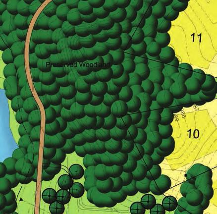
11 SITE PLAN
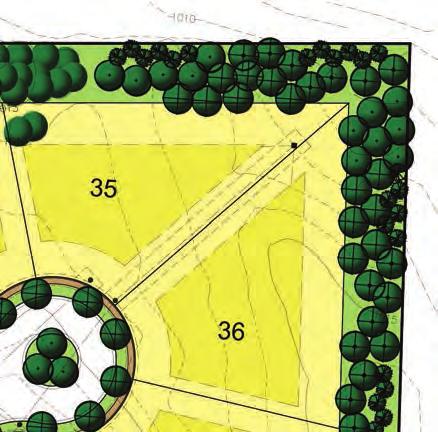
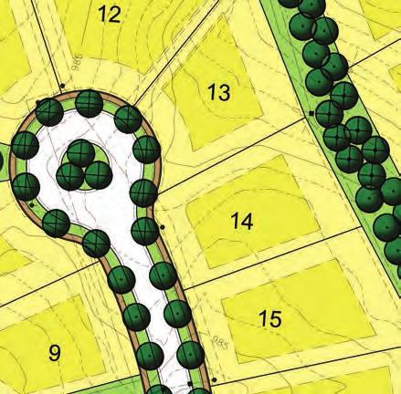


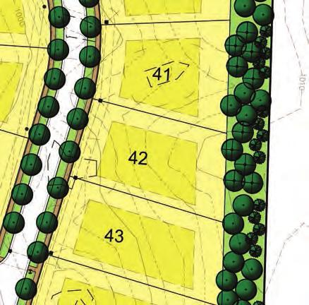
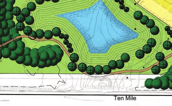
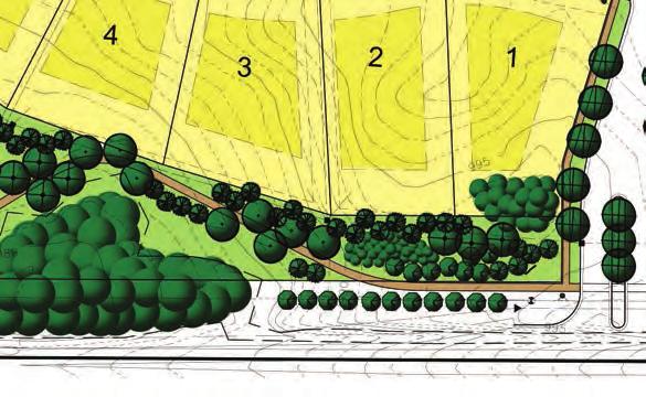
12
13 PLANNING REVIEW
 Site Zoning: RA,")
14 PLAN REVIEW CENTER REPORT December 2, 2013 Planning Review The Preserve at Island Lake (Phase 8) JSP13-69 Petitioner Toll Brothers, Inc. Review Type RUD Plan and Agreement Amendment and Revised Preliminary Site Plan Property Characteristics Site Location: Northeast corner of Ten Mile Road and Napier Roads (Section 19) Site Zoning: RA, Residential Acreage Adjoining Zoning: North and East: RA with RUD; South: RA and R-1; West: Lyon Township R- 2.5 Agricultural Residential Current Site Use: Vacant Adjoining Uses: North and East: Single-family residential/existing RUD; South: Links of Novi golf course and church; West: Lyon Township Agricultural School District: South Lyon Community Schools Site Size: acres Plan Date: Project Summary The applicant is proposing to add a acre parcel at the northeast corner of Ten Mile and Napier Roads to the existing Island Lake of Novi Residential Unit Development (RUD) Agreement in order to construct 45 single-family residential units. The existing agreement provides review standards for the development of the property where the terms of the development differ from the underlying ordinance standards. There are currently 858 units constructed or approved in the existing Island Lake development. The addition of 45 units would bring the total number of units to 903 units, which is more than the amount permitted in the existing RUD Agreement (884 units). The applicant therefore needs to amend the current Island Lake RUD Agreement to reflect the additional units and acreage. The ordinance states that an RUD shall include detached one-family dwelling units, as is proposed in this phase. The applicant has not proposed any attached units, clubhouses, churches, schools or other uses that may be permitted as a part of the proposed development phase. While a variety of housing types is expected in an RUD, the overall density generally shall not exceed the density permitted in the underlying zoning district. The applicant has provided a statement that the proposed density will decrease from 0.92 units/acre to 0.90 units/acre if the RUD Amendment is approved. The Island Lake Development is a combination of R-1, One Family Residential, and RA, Residential Acreage zoning. Recommendation Staff recommends approval of the Amended RUD Plan and Agreement and of the Preliminary Site Plan to allow for The Preserve of Island Lake (Phase 8) to be added to the Island Lake of Novi development provided that the Planning Commission recommends and the City Council finds that the proposed plan meets the Zoning Ordinance standards for a major change to an approved RUD, as outlined in this letter.
15 Planning Review December 2, 2013 The Preserve at Island Lake (Phase 8) Page 2 of 6 JSP13-69 RUD Standards Any amendment or revision constituting a major change in the approved RUD plan shall be reviewed as if it were a new RUD plan. An increase in the number of dwelling units is considered a major change. The Planning Commission and City Council should consider the following when evaluating the proposed RUD amendment. Staff comments are underlined and bracketed. a) The appropriateness of the site for the proposed use; b) The effects of the proposed use upon adjacent properties and the community; [Uses permitted in the single-family zoning districts are proposed or existing on the surrounding parcels.]; c) The demonstrable need for the proposed use; d) The care taken to maintain the naturalness of the site and to blend the use within the site and its surroundings; [The site contains several wetlands and woodlands, and care has been taken to avoid impacts to these features when possible.]; e) The existence of clear, explicit, substantial and ascertainable benefits to the City from the RUD. [The applicant has provided a narrative (attached) describing the benefits of the RUD.] The Planning Commission and City Council shall consider the following factors noted in Section as part of their evaluation of the RUD Amendment. Staff comments are italicized and bracketed. a) Whether all applicable provisions of this Section [2402 of the Zoning Ordinance], other applicable requirements of this Ordinance, including those applicable to special land uses, and all applicable ordinances, codes, regulations and laws have been met. [The applicant has submitted the required application information.] b) Whether adequate areas have been set aside for all schools, walkways, playgrounds, parks, recreation areas, parking areas and other open spaces and areas to be used by residents of the development. The applicant shall make provisions to assure that such areas have been or will be committed for those purposes. [The applicant has set aside 20.4 acres or 45.3% of the proposed development area as open space, of which acres are upland useable acres. Also proposed is walking path that connects the neighborhood to Napier and Ten Mile Roads. In addition, the applicant has offered to construct a new kiddie pool at the Island Lake Clubhouse. Staff recommends the addition of a bike rack at the Island Lake Clubhouse in keeping with the spirit of the newly adopted bicycle parking ordinance to improve access to this shared facility.] c) Whether traffic circulation features within the site and the location of parking areas are designed to assure safety and convenience of both vehicular and pedestrian traffic both within the site and in relation to access streets. [The applicant has provided for safe traffic flow as indicated in the traffic review letter.] d) Whether, relative to conventional one-family development of the site, the proposed use will not cause any detrimental impact in existing thoroughfares in terms of overall volumes, capacity, safety, travel times and thoroughfare level of service, or, in the alternative, the development will provide onsite and offsite improvements to alleviate such impacts. [The development will not have a detrimental impact on existing thoroughfares over and above development under the existing zoning as indicated in the traffic review letter.] e) Whether there are or will be, at the time of development, adequate means of disposing of sanitary sewage, disposing of stormwater drainage, and supplying the development with water. [The applicant has provided for adequate stormwater management and utilities.]
16 Planning Review December 2, 2013 The Preserve at Island Lake (Phase 8) Page 3 of 6 JSP13-69 f) Whether, and the extent to which, the RUD will provide for the preservation and creation of open space. Open space includes the preservation of significant natural assets, including, but not limited to, woodlands, topographic features, significant views, natural drainage ways, water bodies, floodplains, wetlands, significant plant and animal habitats and other natural features. Specific consideration shall be given to whether the proposed development will minimize disruption to such resources. Open space also includes the creation of active and passive recreational areas, such as parks, golf courses, soccer fields, ball fields, bike paths, walkways and nature trails. [The applicant has set aside 20.4 acres or 45.3% of the proposed development area as open space, of which acres are upland useable acres. Also proposed is walking path that connects the neighborhood to Napier and Ten Mile Roads. In addition, the applicant has offered to construct a new kiddie pool at the Island Lake Clubhouse. Staff recommends the addition of a bike rack at the Island Lake Clubhouse in keeping with the spirit of the newly adopted bicycle parking ordinance to improve access to this shared facility.] g) Whether the RUD will be compatible with adjacent and neighboring land uses, existing and master planned. [Uses permitted in the single-family zoning districts are proposed or existing on the surrounding parcels.] h) Whether the desirability of conventional residential development within the City is outweighed by benefits occurring from the preservation and creation of open space and the establishment of school and park facilities that will result from the RUD. [Additional open space and a connected walking path is proposed with this phase. In addition, the applicant has offered to construct a new kiddie pool at the Island Lake Clubhouse. Residents of this phase would have access to the parks and open space created in earlier phases of the Island Lake Development.] i) Whether any detrimental impact from the RUD resulting from an increase in total dwelling units over that which would occur with conventional residential development is outweighed by benefits occurring from the preservation and creation of open space and the establishment of school and park facilities that will result from the RUD. j) Whether the proposed reductions in lot sizes and setback areas are the minimum necessary to preserve and create open space, to provide for school and park sites, and to ensure compatibility with adjacent and neighboring land uses. [A reduction in lot sizes below the Zoning Ordinance standards is proposed, however it is consistent with earlier phases of the Island Lake Development.] k) Evaluation of the impact of RUD development on the City's ability to deliver and provide public infrastructure and public services at a reasonable cost and with regard to the planned and expected contribution of the property to tax base and other fiscal considerations. l) Whether the applicant has made satisfactory provisions for the financing of the installation of all streets, necessary utilities and other proposed improvements. m) Whether the applicant has made satisfactory provisions for future ownership and maintenance of all common areas within the proposed development. [The new development area would be included in the amended Master Deed and By-laws for the Island Lake of Novi development.]
17 Planning Review December 2, 2013 The Preserve at Island Lake (Phase 8) Page 4 of 6 JSP13-69 n) Whether any proposed deviations from the area, bulk, yard, and other dimensional requirements of the zoning ordinance applicable to the property enhance the development, are in the public interest, are consistent with the surrounding area, and are not injurious to the natural features and resources of the property and surrounding area. Ordinance Requirements This project was reviewed for conformance with the standards of the RUD Agreement. Where the agreement fails to address an item of review, the underlying ordinance standards govern the review of the site including standards in Article 3 (RA Residential Acreage District), Article 24 (Schedule of Regulations), Article 25 (General Provisions) and any other applicable provisions of the Zoning Ordinance. Items in bold below must be addressed by the applicant and or Planning Commission/City Council. 1. RUD Intent: As an optional form of development, the RUD allows development flexibility of various types of residential dwelling units (one-family, attached one-family cluster). It is also the intent of the RUD option to permit permanent preservation of valuable open land, fragile natural resources and rural community character that would be lost under conventional development. This is accomplished by permitting flexible lot sizes in accordance with open land preservation credits when the residential developments are located in a substantial open land setting, and through the consideration of relaxation of area, bulk, yard, dimensional and other zoning ordinance standards in order to accomplish specific planning objectives. This flexibility is intended to reduce the visual intensity of development; provide privacy; protect natural resources from intrusion, pollution, or impairment; protect locally important animal and plant habitats; preserve lands of unique scenic, historic, or geologic value; provide private neighborhood recreation; and protect the public health, safety and welfare. Such flexibility will also provide for: The use of land in accordance with its character and adaptability; The construction and maintenance of streets, utilities and public services in a more economical and efficient manner; The compatible design and use of neighboring properties; and The reduction of development sprawl, so as to preserve open space as undeveloped land. Amendments and Revisions to an approved RUD plan shall require all procedures and conditions that are required for original submittal and review for amendments that are considered major changes. The addition of land area and increase in the number of dwelling units are both considered major changes, so full review of the ordinance standards is necessary at this time. 2. Density: The currently approved RUD Agreement allows up to 884 dwelling units. A total of 858 dwelling units have been approved for the development through existing site plan approvals. The applicant is seeking to add 45 units in this phase which would bring the total number of units to 903 and would decrease the permitted density from 0.92 units per acre to 0.90 units per acre for the entire Island Lake of Novi development as illustrated in the table on the following page.
18 Planning Review December 2, 2013 The Preserve at Island Lake (Phase 8) Page 5 of 6 JSP13-69 Density Unit by Type Island Lake of Novi Unit Type Approved in RUD Agreement Approved to Date 1 Currently Proposed 2 Single-Family Attached Cluster 219 Waterfront/ Woodland Attached Cluster 158 Combined 294 Combined 294 Single-Family Detached Single-Family Detached Waterfront (1 acre+) TOTAL DWELLING UNITS Approved to Date includes: Vineyards (Phase 2A) Arbors, Arbors East, North Woods, Shores North, & Vineyards (Phase 2B) Vineyards (Phase 3A, B & C) South Harbor (Phase 3D) Shores South (Phase 4A) Orchards (Phase 4B-1 & 2) 2 Currently Proposed includes the 45 lots proposed as the Preserve at Island Lake (Phase 8) Shores South (Phase 5A) Orchards (Phase 5B & C) North Bay (Phase 6) The Meadows (Phase 7A, B & C) 3. Lot Size and Area: One-family detached dwellings are subject to the minimum lot area and size requirements of the underlying district. RA zoning requires 43,560 sq. ft. lots that are a minimum of 150 ft. wide. The applicant has proposed a minimum size of 14,440 sq. ft. and a minimum width of ft., consistent with the currently approved RUD Agreement standards. The City Council may modify lot size and width requirements where such modification will result in the preservation of open space for those purposes set forth in Section B of the Zoning Ordinance and where the RUD will provide a genuine variety of lot sizes. The plans indicate that a total of 20.4 acres of open space will be maintained in this phase of development, which is approximately 45% of the area in this phase. The applicant has provided a summary of lot sizes throughout the entire development. Taken as a whole, there are a variety of lot sizes throughout Island Lake of Novi. In the proposed phase, lots range from 14,440 sq. ft. to 30,920 sq. ft., allowing for some variation in lot size. This is consistent with other phases of Island Lake of Novi. 4. Private Parks and Recreation Areas: As part of this phase, the applicant is proposing to construct a new children s swimming pool at the Island Lake Clubhouse, which is the result of feedback gathered at a town hall meeting held with residents to discuss this project. In addition, the applicant has agreed to install a bike rack at the Island Lake Clubhouse in keeping with the spirit of the newly adopted bicycle parking ordinance. 5. Sidewalks/Pathways. Sidewalks proposed along all internal roads and a meandering 6 ft. sidewalk is proposed along Ten Mile Road and an 8 ft. pathway is proposed along Napier Road. Pathways and sidewalks are required to be located within 1 foot of the future right-of-way, unless otherwise directed by the City Engineer, for the enhancement of natural resources. The City Council may grant variances to construct the path as proposed. The Engineering Department is maintaining their recommendation to have a more direct path along the southern portion of Napier Road as depicted in Option A; however the applicant has indicated their preference to construct the path as illustrated in Option B. 6. Special Land Use: The Planning Commission shall also consider the standards for Special Land Use approval as a part of its review of the proposed RUD modification, per Section B. 7. Master Deed and By-laws: The amended Master Deed and By-laws must be submitted for review with the Final Site Plan submittal. 8. Signage: Exterior Signage is not regulated by the Planning Division or Planning Commission. Please contact Jeannie Niland ( or jniland@cityofnovi.org) for information regarding sign permits.
19 Planning Review December 2, 2013 The Preserve at Island Lake (Phase 8) Page 6 of 6 JSP13-69 Street and Project Name The proposed project and street names have been reviewed by the Street and Project Naming Committee. The names were approved as requested, with the exception of Napavine Court which was renamed to Denali Court. Please see the attached letter or contact Richelle Leskun ( or rleskun@cityofnovi.org) in the Community Development Department for additional information. Site Addressing The applicant should contact the Building Division for an address prior to applying for a building permit. Building permit applications cannot be processed without a correct address. The address application can be found on the City s website at under the forms page of the Community Development Department. Please contact Jeannie Niland ( or jniland@cityofnovi.org) in the Community Development Department with any specific questions regarding addressing of sites. Pre-Construction Meeting Prior to the start of any work on the site, Pre-Construction (Pre-Con) meetings must be held with the applicant s contractor and the City s consulting engineer. Pre-Con meetings are generally held after Stamping Sets have been issued and prior to the start of any work on the site. There are a variety of requirements, fees and permits that must be issued before a Pre-Con can be scheduled. If you have questions regarding the checklist or the Pre-Con itself, please contact Sarah Marchioni ( or smarchioni@cityofnovi.org) in the Community Development Department. Chapter 26.5 Chapter 26.5 of the City of Novi Code of Ordinances generally requires all projects be completed within two years of the issuance of any starting permit. Please contact Sarah Marchioni ( or smarchioni@cityofnovi.org) for additional information on starting permits. The applicant should review and be aware of the requirements of Chapter 26.5 before starting construction. Response Letter A letter from either the applicant or the applicant s representative addressing comments in this and other review letters is required prior to consideration by the Planning Commission. If the applicant has any questions concerning the above review or the process in general, do not hesitate to contact me at or sroediger@cityofnovi.org. Sara Roediger, AICP Planner Attachments: Planning Review Chart
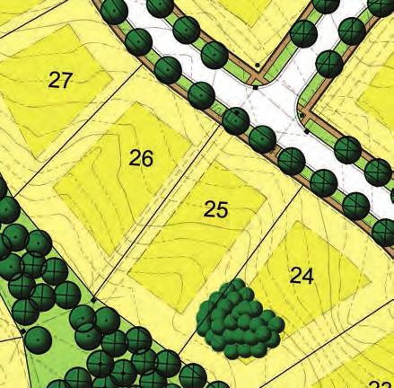
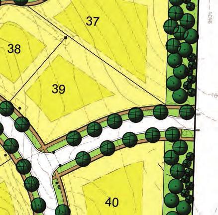
20 Planning Review Summary Chart JSP13-69 The Preserve at Island Lake (Phase 8) Revised Preliminary Site Plan and RUD Amendment Plan Date: Item Property is master planned for single family residential use Zoning is currently RA, Residential Acreage Use (Sec. 2402) single family detached homes, etc. Density (RUD term) 884 dwelling units permitted under current RUD agreement Island Lake has 858 dwelling units under currently approved site plans Proposed No change Inclusion in the Island Lake of Novi RUD 45 single-family, detached homes proposed The applicant has proposed to add 45 units to the RUD, bringing the total number of units that could be constructed up to 903 units Meet Requirements? Yes Yes Yes RUD Ordinance Standards (Sec. 2402) Required property size acres Yes 20 acres Detached one-family Detached onefamily dwellings Yes dwellings permitted Minimum Lot Size (Sec & RUD term) One-family detached dwellings are subject to the Range from min. min. lot area requirements lot size of 14,440 sq. of the RA zoning district: ft. to a max. of 43,560 sq. ft. lots 30,920 sq. ft. Non-waterfront lots in the RUD are required to be a min. of 12,000 sq. ft. Minimum Lot Width (Sec & RUD term) One-family detached dwellings are subject to the min. lot width requirements of the RA zoning district: 150 ft. lot widths Non waterfront lots in the RUD are required to be a min. of 90 ft. wide Range from min. lot width of ft. to a max. of ft. Does not meet ord. requirements but meets previous RUD Agreement terms Does not meet ord. requirements but meets previous RUD Agreement terms Comments The applicant has indicated the total density of the Island Lake of Novi development will be 0.90 units per acre, below the approved density of 0.92 units per acre An amendment to the Island Lake RUD Agreement must be submitted reflecting the additional units to the number of dwelling units permitted in the current RUD The City Council may modify such lot area requirements where such modification will result in the preservation of open space for those purposes set forth in subpart B and where the RUD will provide a genuine variety of lot sizes The City Council may modify such lot width requirements where such modification will result in the preservation of open space for those purposes set forth in subpart B and where the RUD will provide a genuine variety of lot sizes
21 JSP The Preserve at Island Lake (Phase 8) Page 2 of 3 Revised Preliminary Site Plan and RUD Amendment Item Building Setbacks (Sec & RUD term) One-family detached dwellings shall be subject to the min. requirements of the RA zoning district: Front: 45 ft. Rear: 50 ft. Side: 20 ft. Side Combined: 50 ft. If lot sizes are reduced in accord. with Sec yard requirements shall be governed by that zoning district which has min. lot area & width standards that correspond to the dimensions of the particular lot, for 90 ft. wide lots: Front: 30 ft. Rear: 35 ft. Side: 10 ft. Side Combined: 30 ft. Minimum Floor Area (Sec. 2400) Units must be greater than 1,000 sq. ft. Building Height (Sec. 2400) Buildings shall not exceed 2 ½ stories or 35 feet Sidewalks/Pathways (RUD term, Sec (d) & Sec (b)(5)) A pedestrian network plan was approved as part of the RUD which requires sidewalks along all internal roads 8 ft. pathway required along Napier Rd. & a 6 ft. sidewalk required along Ten Mile Rd. Proposed Front: Min. 30 ft. Rear: 35 ft. Side: 10 ft. Side Combined: 30 ft. Entire building envelope shown on plans Min. unit size not shown or required at this point No elevations provided at this time Sidewalks proposed along all internal roads Meandering 6 ft. sidewalk is proposed along Ten Mile Rd. & 8 ft. pathway along Napier Rd. Meet Requirements? Yes N/A N/A Yes/No Comments Building size reviewed at plot plan phase Building height reviewed at plot plan phase Pathways & sidewalks are required to be located within 1 ft. of future ROW, unless otherwise directed by the City Engineer, for the enhancement of natural resources. The City Council may grant variances to construct the path as proposed The Engineering Department is maintaining their recommendation to have a more direct path along the southern portion of Napier Road as indicated as Option A; however the applicant has indicated their preference to construct the path as illustrated in Option B
22 JSP The Preserve at Island Lake (Phase 8) Page 3 of 3 Revised Preliminary Site Plan and RUD Amendment Item Open Space (RUD term) The RUD includes an open space plan, indicating certain areas to be set aside as community open space Bicycle Parking (Sec. 2526) Lighting (Sec. 2511) Proposed The current plan does not encroach into those areas designated for open space A bike rack at the Island Lake clubhouse One 12 ft. tall street light in the Nepavine Dr. island at Ten Mile Rd. Meet Requirements? Prepared by Sara Roediger, AICP or sroediger@cityofnovi.org Yes Yes Yes Comments 20.4 acres or 45.3% of the site has been preserved as open space, of which acres are upland useable acres While no bicycle parking spaces are required, the applicant has agreed to install a bike rack at the Island Lake Clubhouse in keeping with the spirit of the newly adopted bicycle parking ordinance Density Unit by Type Island Lake of Novi Unit Type Approved in RUD Agreement Approved to Date 1 Proposed to Date 2 Single-Family Attached Cluster 219 Waterfront/ Woodland Attached Cluster 158 Combined 294 Combined 294 Single-Family Detached Single-Family Detached Waterfront (1 acre+) TOTAL DWELLING UNITS Approved to date includes: Vineyards (Phase 2A) Arbors, Arbors East, North Woods, Shores North, & Vineyards (Phase 2B) Vineyards (Phase 3A, B & C) South Harbor (Phase 3D) Shores South (Phase 4A) Orchards (Phase 4B-1 & 2) 2 Proposed to date includes the 45 lots proposed as the Preserve at Island Lake (Phase 8) Shores South (Phase 5A) Orchards (Phase 5B & C) North Bay (Phase 6) The Meadows (Phase 7A, B & C)
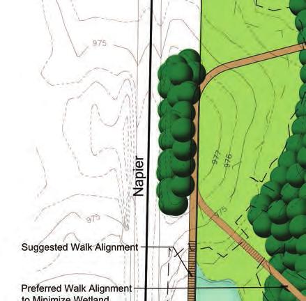
23 TO: PLANNING COMMISSION FROM: SARA ROEDIGER, AICP, PLANNER THROUGH: BARBARA MCBETH, AICP, DEPUTY DIRECTOR OF COMMUNITY DEVELOPMENT SUBJECT: THE PRESERVE AT ISLAND LAKE (PHASE 8), JSP13-69 PATHWAY ALIGNMENT ON NAPIER ROAD DATE: DECEMBER 5, 2013 MEMORANDUM Discussion Item: Pathway Alignment on Napier Road As discussed in the planning, engineering and wetland reviews, a meandering 6 ft. sidewalk is proposed along Ten Mile Road and an 8 ft. pathway is proposed along Napier Road. Pathways and sidewalks are required to be located within 1 foot of the future right-of-way, unless otherwise directed by the City Engineer, for the enhancement of natural resources. The City Council may grant variances to deviate from this requirement. Through the review process, two alternatives for the pathway along the southern portion of Napier Road have emerged as the result of two important yet sometimes competing interests to preserve natural features and to provide a comprehensive and efficient non-motorized pathway system in the City. A comparison of the pros and cons for each option is provided in the table below. Option A (Suggested Walk Alignment) Minimize the amount of deviation requested from City Ordinances Direct connection to the intersection of Napier Rd. and Ten Mile Rd. Require construction of a 260 ft.+ boardwalk that would result in greater wetland impact and greater maintenance costs May require additional tree removals Design is a linear path that abuts the street Option B (Applicant Preferred Walk Alignment) Require a deviation of up to 200 ft. at the furthest point (which is consistent to the deviation being considered along the northern portion of Napier Road due to wetlands) People traveling north/south on Napier Rd. would need to travel 200 ft. out of their way, may result in people traveling in the Napier Rd. right-of-way Require construction of a 40 ft.+ boardwalk that would result in less wetland impact due to a shorter wetland crossing and less maintenance costs Minimize the amount of tree removal Design may result in a more interesting path that may be more enjoyable to traverse Recommendation Staff can see the merits of each of the options and suggest the Planning Commission review this matter and provide a recommendation to the City Council. Both options will result in a connected pathway system that respects the natural landscape, and as result staff continues to recommend Option A along the Napier Rd. frontage since this option most closely matches the ordinance standards.

24 Option A Option B
25 ENGINEERING REVIEW
26
27
28
29
30

31 MEMORANDUM TO: ROB HAYES, DIRECTOR OF PUBLIC SERVICES/CITY ENGINEER FROM: TIM KUHNS, SENIOR WATER AND SEWER ENGINEER SUBJECT: DRAKES BAY SYSTEM CAPACITY ANALYSIS DATE: NOVEMBER 7, 2013 Introduction The City of Novi recognizes the importance of better managing its sanitary collection system in order to meet regulatory and customer expectations, including ensuring that adequate capacity is available for existing customers and new development. With this objective in mind, the Water and Sewer Division has performed an evaluation of the Drakes Bay pump station tributary area to evaluate the pump station performance for peak flow conditions during existing and future development scenarios. Figure 1 shows the location and layout of the Drakes Bay pump station study area. Figure 1: Drakes Bay Pump Station Service Area
32 Methodology The evaluation of peak design flows for the study area used the following methodology: 1. Perform Infiltration and Inflow (I/I) Analysis of System An analysis of the I/I levels within the system was performed to demonstrate how antecedent moisture (i.e., the level of soil saturation before a storm event) and rainfall conditions impact peak flows and hydrograph volumes. 2. Evaluation of Existing Flows (Hydrologic Model Development) A hydrologic model was calibrated using rainfall, temperature, and flow measurements from the Drakes Bay pump station tributary area using the i3d antecedent moisture model during the monitoring period from 2009 to present to characterize the existing system flows during wet weather conditions. The hydrologic model calibration results are contained in the Appendix. Once the hydrologic model is calibrated such that it provides a good representation of system flows, the model is used to develop a long term simulation of flows to estimate the peak design flows to the station as defined by the Michigan Department of Environmental Quality (MDEQ). 3. Evaluation of Future System Flows To evaluate future system flows, site plans were compiled from recent development site plan submittals to estimate additional planned development flows. For remaining vacant parcels, a development density was assumed based on land use master planning to estimate additional future development flows. The estimated flows based on these planned and future developments were then added to the existing flows to establish a future design flow condition. 4. Recommended Upgrades for Existing and Future Design Flow Conditions Once the peak design flows were estimated as part of the frequency analysis, the pump station performance could be evaluated for existing and future flow conditions. System upgrades would be identified to accommodate design flows. I/I Analysis An analysis of I/I levels within the system was performed at the Drakes Bay pump station to demonstrate how antecedent moisture and rainfall conditions impact peak flows. I/I levels were quantified by computing capture coefficients for several key storm events during the flow monitoring period from 2009 to present. The capture coefficient represents the percent of the total rainfall volume over the service area that enters the sanitary collection system. A summary of the I/I analysis for the Drakes Bay pump station is provided in Table 1. 2
33 Table 1: I/I Analysis of the Drakes Bay Pump Station Storm Rain (in) RDII Volume (Mcf) Capture % 8/8/ % 6/4/ % 4/27/ % 5/15/ % 5/24/ % 7/27/ % 3/2/ % 7/27/ % 4/11/ % 4/17/ % 4/23/ % Notes 1. RDII = Rainfall Dependent Inflow and Infiltation 2. Total Service Area = 612 acres. 3. Mcf = Thousands of cubic feet 4. RDII Volumes do not contain base groundwater flows Highest C% 0.70% Lowest C% 0.02% AM Variability % The I/I analysis indicates that the capture coefficients can vary by as much as 3,500% for different storm events. The analysis also shows that (per inch of rain) the capture coefficients are typically higher during the wet spring months and lower during the dry summer. These findings indicate that antecedent moisture conditions vary significantly between events and that a hydrologic model that takes into account varying antecedent moisture conditions is needed to analyze the system. Evaluation of Existing Flows (Hydrologic Model Development) The i3d Antecedent Moisture (AM) Model was calibrated and validated using hydrologic measurements for the Drakes Bay tributary area from 2009 to present to characterize the system flows during wet weather conditions. The i3d model uses rainfall and air temperature to continuously determine the surface and sub-surface soil moisture conditions and adjusts the hydrologic model to account for these varying antecedent moisture conditions. The calibration results for the Drakes Bay pump station are presented in Table 2. 3
34 Storm Rain (in) Table 2: Summary of Calibration Results Observed Peak (cfs) Model Peak (cfs) Peak Flow Error (%) Observed Vol (1000's cf) Model Vol (1000's cf) Volume Error (%) 08/08/ % % 06/04/ % % 05/14/ % % 04/26/ % % 05/24/ % % 06/17/ % % 02/28/ % % 04/17/ % % 04/10/ % % 04/28/ % % Net Average Error -3.1% -0.7% Total Average Error 18.2% 12.4% Both net error and total error were calculated in Table 2. Net error is the average of all the errors and allows positive and negative values to offset each other. The net error is a measure of the model bias and should be as close to zero as possible. Total error is the average of the absolute value of the errors and is a measure of the model s ability to predict volumes and flows for individual storm events. The detailed calibration and validation results are provided in the Appendix of this memo. A review of the net and total errors shown in Table 2 shows that the calibrated model has a net peak error of -3.1% and a net volume error of -0.7% indicating that the model has little or no bias. The net and total errors are considered excellent for a single, continuous model that simulates capture coefficients that can vary by as much as 3500% from wet and dry conditions, as tabulated in the I/I analysis. These findings indicate that the model is suitable for use in estimating design flow conditions. The MDEQ policy statement on Sanitary Sewer Overflows (SSOs) provides guidance for estimating design flow conditions. The policy states that it does not authorize the discharge of raw or partially treated SSOs; however, enforcement discretion will be considered for collection systems that have capacity to handle the 25-year, 24-hour remedial design storm during growth season and normal soil moisture conditions. The MDEQ SSO policy indicates that systems that have capacity to handle the 25-year, 24-4
35 hour remedial design condition will have on average less than one overflow per ten years. In effect, the policy allows for continuous simulation and frequency analysis to estimate the 10-year frequency design flow condition (less than one overflow per ten years). In order to perform a frequency analysis of flows to estimate design flow conditions, the calibrated hydrologic model was used to simulate a long-term record of flow for the study area using rainfall and temperature measurements from Detroit City Airport (DCA) from 1949 to 2000 as inputs to the model. The simulated record of flows represents the predicted flows for the Drakes Bay pump station study area assuming that the DCA rainfall pattern (from 1949 to 2000) fell over the study area. The predicted flows should provide a good representation of study area flows as the model had good calibration results. The DCA gage was used as it was the nearest gage with long-term and reliable rainfall data for the purposes of a long-term simulation. The location of the rain gage is not as important as having a rain gage that provides a good representation of the regional long-term climate patterns of the study area. Examination of the intensity, duration and frequency (IDF) characteristics published in the Rainfall Frequency Atlas of the Midwest (Huff & Angel, 1992) shows very little difference in the IDF characteristics between the DCA gauge and the study area. The top fifty-two (52) peak flow rates from the long-term flow simulation were summarized as a partial duration series and this series was used to perform a frequency analysis to estimate the 10-year frequency design flow condition. Figure 2 depicts the frequency analysis for the Drakes Bay pump station. As the final check in the calibration process, a macro-level comparison was also performed with the frequency analysis by plotting the actual yearly maximum flow rates measured at the pump station from 2009 to The blue triangle data points represent the actual measured flows and show concurrence with the modeled data points indicating an overall good model fit. 5
36 Figure 2: Drakes Bay Pump Station Frequency Analysis 0.01 model Log Pearson Type III Distribution Observed Annual Probability Year Peak I/I Flow = 1.00 cfs (448 gpm) Peak I/I Flow (cfs) Table 3 summarizes the existing design flows to the Drakes Bay pump station. The evaluation of existing flows indicates that the current design flows to the pump station are close to exceeding of the pump station capacity. Table 3: Existing Design Flows to Pump Station Existing Base Flow 0.04 cfs metered Projected Design Wet Weather Flow 1.00 cfs From Statistics Existing Design Peak Flow 1.04 cfs A + B Current PS Capacity 1.11 cfs From Pump Curves Evaluation of Future System Flows To evaluate future system flows, plans were compiled from recent development site plan submittals to estimate additional planned development flows. For remaining vacant parcels, a development density was assumed based on land use master 6
 for the Drakes Bay pump station district.")
37 planning to estimate additional future development flows. Figure 3 provides a map depiction of the future users and associated residential equivalent units (REUs) for the Drakes Bay pump station district. Figure 3: Future Users and REUs Table 4 provides a summary of the planned developments, which have pending site plan submittals or special assessment district (SAD) petitions that are likely to connect to the pump station within the next five years. Table 4: Planned Connections within the Drakes Bay Service Area Island Lake Phase 8 45 REU Island Lake Phase 7 74 REU Pebble Ridge & Offsite 56 REU Additional Short-Term Development 175 REU Estimated Short Term Population Growth 560 persons Additional Short-Term Dry Weather Flows 0.09 cfs Additional Short-Term Peak Flows 0.34 cfs Notes persons per REU assumed gallons per person per day assumed States Peaking Factor Equation Used: (18+(P/1000)^0.5)/(4+(P/1000)^0.5) 7
38 The analysis of planned connections indicates short-term capacity upgrades are needed to the Drakes Bay Pump Station to increase the station s capacity to 1.38 cfs to accommodate the existing (1.04 cfs) and planned (0.34 cfs) flows to the station. Table 5 provides a summary of all future developments that would connect to the system based on full build-out. Table 5: Future System Flows Future Connections 866 REU Estimated Population Growth for Pump Station Additional Average Dry Weather Flow at 100 gpcd 2771 Persons 0.43 cfs Additional Future Peak Flow 1.49 cfs Notes persons per REU assumed gallons per person per day assumed States Peaking Factor Equation Used: (18+(P/1000)^0.5)/(4+(P/1000)^0.5) In Table 5, the future additional flows were computed based on the estimated number of additional users as presented in Figure 3. To evaluate the total future flows to the Drakes Bay pump station, the existing flows were added to the future additional flows. A summary of the total future flows is contained in Table 6. Table 6: Summary of Future Total Flows Existing Design Peak Flow 1.04 cfs Additional Future Peak Flow 1.49 cfs Total Future Design Peak Flow 2.53 cfs The existing capacity of the Drakes Bay Pump Station is 1.11 cfs, which will be exceeded during short-term (1.38 cfs) and full build-out (2.53 cfs) design flow conditions. Therefore, upgrades are required at the pump station to convey short-term and full build-out design flows. 8
39 Recommended Upgrades for Existing and Full Build-Out Flow Conditions Based on the flow analysis, short-term and full build-out design flow conditions required upgrades to the Drakes Bay Pump Station as follows: 1. Short-Term Upgrades are needed to the Station to increase the capacity to 1.38 cfs (620 gpm). The existing system curve for the Station is presented in Figure 4. Figure 4: Drakes Bay System Curve Short-Term Upgrades Existing System Curve Proposed Duty Point The system curve calculations should be verified, but assuming that the original system curve was computed correctly, the proposed duty point for the upgrades is 1.38 cfs ( ft. TDH. It will be necessary to evaluate whether the existing pumps can be fit with a larger impeller, or if larger pumps are necessary to accommodate the new duty point. If larger pumps are needed, it will also be necessary to verify that the existing wet-well (6 ft. diameter) and electrical systems (including generator) are large enough to accommodate larger pumps. 9
40 2. Full Build-Out Upgrades are needed to the Station to increase the capacity to 2.53 cfs (1,135 gpm). The existing system curve for the Station is presented in Figure 5. Figure 5: Drakes Bay System Curve Full Build-Out Upgrades Proposed Duty Point Existing System Curve Assuming that the original system curve was computed correctly, the proposed duty point for the upgrades is approximately 2.53 cfs (1, ft. TDH. Larger pumps will be necessary to accommodate the full build-out duty point. It will be necessary to verify that the existing wet-well (6 ft. diameter) and electrical systems (including generator) are large enough to accommodate larger pumps. For future build-out conditions, a capacity analysis of the receiving sewer downstream of the Drakes Bay Pump Station should be performed to evaluate if upgrades are needed to this sewer. The existing 12-inch receiving sewer has a nominal capacity of 1.95 cfs and the future build-out design flow from the Drakes Bay Pump Station is 2.53 cfs. This finding indicates upgrades are needed to this portion of the collection system. The capacity analysis for this portion of the system will be summarized in a separate Wixom Road System Capacity Analysis technical memo. 10
41 Cc: Brian Coburn, Engineering Manager Adam Wayne, Staff Engineer Scott Roselle, Water and Sewer Asset Manager 11
42 Appendix Model Calibration Results

43 Drakes Bay Pump Station Model Parameters Model version : i3dlab v. 2.8 r.30
44 Drakes Bay PS - Antecedent Moisture Model - Accuracy of Fit Analysis Calibration Events Storm Rain (in) Observed Peak (cfs) Model Peak (cfs) Peak Flow Error (%) Observed Vol (1000's cf) Model Vol (1000's cf) Volume Error (%) 08/08/ % % Notes Flow (cfs) on primary Y axis, Rain (in) on secondary Y axis) Net Average Error 19.2% 46.7% Total Average Error 9.6% 23.3% Observed Modeled Rain /7 8/9 8/11 8/13 8/15 8/17
45 Drakes Bay PS - Antecedent Moisture Model - Accuracy of Fit Analysis Calibration Events Storm Rain (in) Observed Peak (cfs) Model Peak (cfs) Peak Flow Error (%) Observed Vol (1000's cf) Model Vol (1000's cf) Volume Error (%) 06/04/ % % Notes Flow (cfs) on primary Y axis, Rain (in) on secondary Y axis) Net Average Error 14.4% -2.6% Total Average Error 7.2% 1.3% Observed Modeled Rain /3 6/5 6/7 6/9 6/11 6/13
46 Drakes Bay PS - Antecedent Moisture Model - Accuracy of Fit Analysis Calibration Events Storm Rain (in) Observed Peak (cfs) Model Peak (cfs) Peak Flow Error (%) Observed Vol (1000's cf) Model Vol (1000's cf) Volume Error (%) 05/14/ % % 04/26/ % % 05/24/ % % Notes Flow (cfs) on primary Y axis, Rain (in) on secondary Y axis) Net Average Error -18.8% -6.7% Total Average Error 17.1% 10.6% Observed Modeled Rain 1 Observed Modeled 1 Rain /25 4/27 4/29 5/1 5/3 5/ /13 5/15 5/17 5/19 5/21 5/ Observed Modeled Rain 1 Observed Modeled 1 Rain /23 5/25 5/27 5/29 5/31 6/ /1 1/1 1/1 1/1 1/1 1/2 1/2
47 Drakes Bay PS - Antecedent Moisture Model - Accuracy of Fit Analysis Calibration Events Storm Rain (in) Observed Peak (cfs) Model Peak (cfs) Peak Flow Error (%) Observed Vol (1000's cf) Model Vol (1000's cf) Volume Error (%) 06/17/ % % 02/28/ % % Notes Flow (cfs) on primary Y axis, Rain (in) on secondary Y axis) Net Average Error -5.3% -11.5% Total Average Error 17.0% 11.5% Observed Series2 0.1 Modeled Rain 1 Series3 Series /16 6/18 6/20 6/22 6/24 6/ /27 2/29 3/2 3/4 3/6 3/8
48 Drakes Bay PS - Antecedent Moisture Model - Accuracy of Fit Analysis Calibration Events Storm Rain (in) Observed Peak (cfs) Model Peak (cfs) Peak Flow Error (%) Observed Vol (1000's cf) Model Vol (1000's cf) Volume Error (%) 04/17/ % % 04/10/ % % 04/28/ % % Notes Flow (cfs) on primary Y axis, Rain (in) on secondary Y axis) Net Average Error 0.7% -2.5% Total Average Error 14.9% 5.5% Observed Modeled Rain 1 Observed Modeled 1 Rain /10 4/12 4/14 4/16 4/18 4/ /16 4/18 4/20 4/22 4/24 4/ Observed Modeled Rain 1 Observed Modeled 1 Rain /26 4/28 4/30 5/2 5/4 5/ /1 1/1 1/1 1/1 1/1 1/2 1/
49 Drakes Bay Pump Station Modeled Year Max Flow (cfs) Rank Ranked Values Log Max Flow (cfs) Annual Probability Return Period (yrs) Annual Probability 0.01 model Log Pearson Type III Distribution Observed Frequency Analysis Statistics (Partial Duration) Drakes Bay PS Year Peak I/I Skew Flow Coeff = cfs #DIV/0! (448 Skew gpm) Coeff 2 #DIV/0! Average #DIV/0! Standard Deviation #DIV/0! Peak I/I Flow (cfs) Cw = Tr K(0.7) K(0.6) olumn Lookslope Q (cfs) Drakes Bay Pump Station Observed Log Max Flow Annual Probabi Ranked Year Max Flow (cfs) Rank Skew Coeff Values (cfs) lity Skew Coeff Average Standard Deviation Variance Cm = (determined from USGS skewness map) #NUM! V(Cm) = 0.30 standard coefficient #NUM! A = #NUM! B = #NUM! n = #NUM! V(Cs) = #NUM! W = #NUM! Cw = #NUM! #NUM! #NUM! #NUM! #NUM! #NUM! Return Period (yrs) #NUM!
50 TRAFFIC REVIEW

51 December 2, 2013 Barbara McBeth, AICP Deputy Director of Community Development City of Novi W. Ten Mile Rd. Novi, MI SUBJECT: Island Lake Phase 8, JSP , Traffic Review of Revised Preliminary Site Plan, PSP Dear Ms. McBeth: At your request, we have reviewed the above and offer the following recommendation and supporting comments. Recommendation We recommend approval, subject to the items shown below in bold being satisfactorily addressed by the final site plan. Site Description What is the applicant proposing, and what are the surrounding land uses and road network? 1. The applicant is proposing a 45-home expansion of the Island Lake RUD. This phase will provide a new access point on Ten Mile as well as have street connections to Phase 5B to the north and Phase 5C to the east. There is a large wetland between the proposed new home sites and Napier Road to the west. 2. Ten Mile Road is a 50-mph two-lane arterial under the jurisdiction of the Road Commission for Oakland County. Based on 2011 traffic counts, this section of Ten Mile is now carrying at least 10,000 vehicles per day. Traffic Study and Trip Generation Was a traffic study submitted and was it acceptable? How much new traffic would be generated? 3. Forty-five single-family homes can be expected to generate 504 daily one-way trips, 41 in the AM peak hour (10 entering and 31 exiting) and 51 in the PM peak hour (32 entering and 19 exiting). Given the proposed connection to Island Lake Phase 5B, additional traffic from/to that phase can be expected to use the new access point on Ten Mile Road (e.g., traffic generated by 65 Phase 5B homes going to and from points west). 4. A traffic study for Phase 8 is unwarranted. As noted in our pre-application comments, however, our analysis shows that a left-turn lane will be required to safely serve left turns into the development. In response, the applicant now proposes such a road improvement. Clearzoning, Inc Southfield Road, Lathrup Village, Michigan Planning Zoning Transportation
52 Island Lake Phase 8, Traffic Review of RPSP P a g e 2 Vehicular Access Locations Do the proposed driveway locations meet City spacing standards? 5. Yes. The nearest existing driveway of any significance is Terra Del Mar Drive, approximately 1,050 ft to the east. Vehicular Access Improvements Will there be any improvements to the abutting road(s) at the proposed access point(s)? 6. A 50-ft-long westbound right-turn lane has been proposed. This length appears appropriate given the speed limit and moderate volume of entering right-turn traffic in the PM peak hour. 7. The proposed widening of Ten Mile for the required eastbound center left-turn lane is still designed incorrectly. As pointed out in our review letter of November 6, the new street s effective centerline is the east curb of the boulevard island. The center lane should run from 150 ft west of that reference to 35 ft east (the revised plan under review references the island s west curb rather than its east curb). 8. The final site plan should include a separate sheet showing MMUTCD-compliant pavement markings associated with the proposed widening of Ten Mile along the site frontage. RCOC should be consulted to see whether or not it wants any special treatment between the center-lane taper striping (e.g., crosshatching or a corrugated divider). Access Drive Design and Control Are the proposed design, pavement markings, and signage satisfactory? 9. The proposed boulevard island would be 100 ft long, the City-maximum length. The back-toback island width would be 16 ft, more than the City standard of 10 ft but within the allowable range of 8-24 ft. Per DCS Figure IX.3, the applicant must show cause for proposing an island width different than the City standard. 10. The final site plan should specify the striping of the proposed crosswalk at Ten Mile Road (assuming City Engineering approves its use at this location). The final site plan should also propose minimal signing a STOP sign 4 ft in advance of the crosswalk and a diagrammatic Keep Right sign at each end of the boulevard island and include such signing in the overall Signing Quantities Table (which will also include other signing internal to the site). Pedestrian Access Are pedestrians safely and reasonably accommodated? 11. The proposed sidewalk stubs on both sides of the internal intersections are consistent with the Complete Streets philosophy and commendable. However, ramps need to be shown in all sidewalk stubs as well as at the crosswalk at Ten Mile. Circulation and Parking Can vehicles safely and conveniently maneuver through the site? Clearzoning Southfield Road, Lathrup Village, Michigan Planning Zoning Transportation
53 Island Lake Phase 8, Traffic Review of RPSP P a g e Overlook Court would be 1,000 ft long, the longest cul-de-sac allowed in a R-A zoning district having a zoning option decreasing lot size below the R-A minimum (e.g., within Island Lake). 13. It appears that all necessary plan-view dimensions related to the proposed street system (road widths, street centerline radii, and curb return radii) are included and meet City standards, with the exception of the two 20-ft-wide traffic calming chokers. A City Council variance of the local-street width standard (28 ft) will be required for the chokers. 14. The final site plan will need to propose City-standard street-name signing at each intersection; a YIELD (R1-2) sign on each minor approach; City-standard Keep Right and No Parking signing on the cul-de-sac turnaround islands; and a 25-mph speed limit (R2-1(25)) sign on the property line between lots 44 and 45. All signing needs should be summarized in a Signing Quantities Table. Sincerely, CLEARZONING, INC. Rodney L. Arroyo, AICP President William A. Stimpson, P.E. Director of Traffic Engineering Clearzoning Southfield Road, Lathrup Village, Michigan Planning Zoning Transportation
54 LANDSCAPE REVIEW
55 PLAN REVIEW CENTER REPORT November 25, 2013 Revised Preliminary Landscape Review Island Lake Phase 8 - JSP13-69 Petitioner Toll Brothers, Inc. Review Type RUD Amendment and Revised Preliminary Site Plan Property Characteristics Site Location: Northeast corner of Ten Mile Road and Napier Roads (Section 19) Site Zoning: RA, Residential Acreage Adjoining Zoning: North and East: RA with RUD; South: RA and R-1; West: Lyon Township R-2.5 Agricultural Residential Current Site Use: Vacant Adjoining Uses: North and East: Single-family residential/existing RUD; South: Links of Novi golf course and church; West: Lyon Township Agricultural School District: South Lyon Community Schools Site Size: acres Plan Date: Recommendation Approval of the RUD Plan and Preliminary Site Plan for Island Lake Phase 8 - JSP#13-69 is recommended. Please address the concerns noted below upon subsequent submittal. Please respond in writing to document any site plan revisions made in regard to the concerns listed below. Ordinance Considerations Adjacent to Residential Buffer (Sec a.) 1. The property is adjacent to residential properties on all sides. No buffer is required. Adjacent to Public Rights-of-Way Berm (Wall) & Buffer (Sec b.) 1. A 3 tall landscape buffer berm is required along the Ten Mile and Napier Road frontages. However, due to the existing vegetation, wetlands and distance of the proposed lots from the roads, this may not be prudent for the entire frontages. Staff recommends that a landscaped berm only be provided along the Ten Mile frontage of lots 1, 2, and 45. The Planning Commission may grant a waiver for the remainder of the frontages. Staff would support the waiver. 2. One canopy tree per 35 l.f. is required along the berm area. This requirement has been met.
56 Revised Preliminary Landscape Plan November 25, 2013 Island Lake Phase 8 Page 2 of 3 3. One subcanopy tree per 20 l.f. is required along the berm area. This requirement has been met. Street Tree Requirements (Sec b.) 1. One street tree is required per 35 l.f. of road frontage. This requirement has been met for the interior roadway. Vegetation along the exterior main roads will be maintained. Parking Landscape (Sec c.) 1. No parking areas are proposed. Building Foundation Landscape (Sec d.) 1. Only single family residences are proposed. No foundation landscape is required under the ordinance. Plant List (LDM) 1. The Plant List meets the requirements of the Ordinance and Landscape Design Manual. Planting Details & Notations (LDM) 1. Planting Details and Notations meet the requirements of the Ordinance and Landscape Design Manual. Storm Basin Landscape (Sec e.(4)) & LDM) 1. A total of 70% to 75% of storm basin rims are required to be planted with large shrubs. While the Applicant has placed trees around the basins, they must add groupings of shrubs to meet the requirement. Irrigation (Sec f.(6)(b)) 1. All landscape areas are required to be irrigated. General 1. Please see woodland and wetland reviews for additional comments. Please follow guidelines of the Zoning Ordinance and Landscape Design Guidelines. This review is a summary and not intended to substitute for any Ordinance. For the landscape requirements, see the Zoning Ordinance landscape section on 2509, Landscape Design Manual and the appropriate items in the applicable zoning classification. Also see the Woodland and Wetland review comments. Reviewed by: David R. Beschke, RLA
57 Revised Preliminary Landscape Plan November 25, 2013 Island Lake Phase 8 Page 3 of 3 Financial Requirements Review To be completed at time of Final Site Plan Review. Item Amount Verified Adjustment Comments Full Landscape Cost Estimate $ 130,884 Includes street trees. Does not include irrigation costs. Final Landscape Review Fee $ 1, % of full cost estimate Any adjustments to the fee must be paid in full prior to stamping set submittal. Financial Requirements (Bonds & Inspections) Item Required Amount Verified Comments Landscape Cost Estimate YES $ 69,684 Does not include street trees. Includes irrigation. Landscape Financial Guaranty YES $ 104,526 This financial guarantee is based upon 150% of the verified cost estimate. For Commercial, this letter of credit is due prior to the issuance of a Temporary Certificate of Occupancy. For Residential this is letter of credit is due prior to preconstruction meeting. Landscape Inspection Fee (Development Review Fee Schedule 3/15/99) Landscape Administration Fee (Development Review Fee Schedule 3/15/99) Transformer Financial Guarantee Street Tree Financial Guaranty Street Tree Inspection Fee Street tree Maintenance Fee Landscape Maintenance Bond YES $ 4, For projects up to $250,000, this fee is $500 or 6 % of the amount of the Landscape cost estimate, whichever is greater. This cash or check is due prior to the Pre-Construction meeting. YES $ This fee is 15% of the Landscape Inspection Fee. This cash or check is due prior to the Pre-Construction meeting. NO $ 0 $500 per transformer if not included above. For Commercial this letter of credit is due prior to the issuance of a Temporary Certificate of Occupancy. For Residential this is letter of credit is due prior to preconstruction meeting. YES $ 61,200 $400 per tree. YES $ 3,672 6% of the Street Tree Bond as listed above. YES $ 3,825 $25 per tree. YES $ 6, % of verified cost estimate due prior to release of Financial Guaranty.
58 WOODLAND REVIEW
59 November 27, 2013 Ms. Barbara McBeth Deputy Director of Community Development City of Novi West Ten Mile Road Novi, MI Re: Island Lake Phase 8 (JSP ) The Preserve at Island Lake Woodland Review of the Revised Preliminary Site Plan (PSP ) Dear Ms. McBeth: Environmental Consulting & Technology, Inc. (ECT) has reviewed the Revised Preliminary Site Plan (Plan) for the proposed The Preserve at Island Lake - Phase 8 project prepared by Alpine Engineering, Inc. dated November 21, 2013 and stamped Received by the City of Novi on November 22, The Plan was reviewed for conformance with the City of Novi Woodland Protection Ordinance Chapter 37. The proposed development is located northeast of the intersection of Ten Mile Road and Napier Road in Section 19. The proposed project involves the construction of a 45-unit site condominium development, associated roads and utilities and storm water detention basin. What follows is a summary of our findings regarding on-site woodlands associated with the proposed project. Onsite Woodland Evaluation ECT has reviewed the City of Novi Official Woodlands Map and completed an onsite woodland evaluation on Wednesday, October 23, The entire site is approximately 49 acres with regulated woodland mapped across the majority of the property (see Figure 1). The site contains sections of old field as well as relatively immature forest and forested wetlands on the west side of the site (along Napier Road). On-site woodland is dominated by black cherry, American basswood, silver maple, box elder, American elm and several other species Commonwealth Blvd., Suite 300 Ann Arbor, MI The surveyed trees have been marked with either metal tags hung on fishing line, or with spray paint, allowing ECT to compare the tree diameters reported on the Tree List to the existing tree diameters in the field. ECT took numerous diameter-at-breast-height (d.b.h.) measurements and found that some of the data provided in the Tree Lists was at times inconsistent with the field measurements. (734) FAX (734) An Equal Opportunity/Affirmative Action Employer
60 Island Lake Phase 8 (JSP ) The Preserve at Island Lake Woodland Review of the Revised Preliminary Site Plan (PSP ) November 27, 2013 Page 2 of 5 A number of inconsistencies that were indicated in our Woodland Review of the Preliminary Site Plan dated November 13, 2013 have now been corrected by the Applicant s Landscape Consultant. Proposed Woodland Impacts Per the Woodland Summary calculations on Sheet L-6 the Plan proposes the removal of 235 regulated trees with d.b.h. greater than or equal to 8 inches, requiring a total of 343 replacement credits. Discrepancies appear to exist between the information provided in the summary tables and that shown in the Tree List information provided on Sheets L-5 and L-6. Assessment of the Tree List information by ECT indicates that a total of 328 Woodland Replacements are required (i.e., this quantity has been calculated by ECT). This result appears to be in conflict with the quantities provided by the Applicant in the summary tables. ECT encourages the Applicant to provide a column on the Tree List (Sheets L-5 and L-6) that provides the Woodland Replacements Required for each proposed tree removal. ECT suggests that the Applicant review and revise the Woodland Replacement requirements as necessary. It should be noted that any individual stems of multi-stemmed trees that are less than 8 inches d.b.h. are not included in the calculation of required Woodland Replacements. This is likely leading to the discrepancy in the required Woodland Replacement quantity. Please note that the City of Novi requires replacements according to the following Table: Replacement Tree Requirements Table Removed Tree D.B.H. (In Inches) Ratio Replacement/ Removed Tree > > As noted in our previous woodland review letter, for multi-stemmed trees, Woodland Replacements required are calculated by summing the d.b.h. of each stem greater than or equal
61 Island Lake Phase 8 (JSP ) The Preserve at Island Lake Woodland Review of the Revised Preliminary Site Plan (PSP ) November 27, 2013 Page 3 of 5 to 8 inches and dividing the total by 8. All fractional Woodland Replacements required are rounded up to the nearest whole tree replacement. Again, stems less than 8-inchs d.b.h. are not included. Woodland Impact Review Per summary calculations in the Woodland Summary (Sheet L-6), the Plan proposes the removal of 235 regulated trees with d.b.h. greater than or equal to 8 inches, requiring a total of 343 replacement credits. After review of the Tree List (Sheets L-5 and L-6) as well as a spreadsheet provided by the Applicant s Landscape Consultant, ECT concurs with the total of 235 regulated trees to be removed. However, as noted above, ECT tallied a total of 328 Woodland Replacement Trees required. This number is not consistent with the number of Woodland Replacements required as indicated on the Plan. Comments 1. A Woodland Permit from the City of Novi would be required for proposed impacts to any trees 8-inch d.b.h. or greater. Such trees shall be relocated or replaced by the permit grantee. All replacement trees shall be two and one-half (2 ½) inches caliper or greater. 2. There appear to be several items on the Landscape Plan (Sheet L-1) that appear to require revision: a. The Plant List Woodland Replacement Trees indicates a total of 392 Woodland Replacement Trees provided (98 evergreen trees and 294 deciduous trees). A tally of the deciduous trees in list appears to result in 293 deciduous trees. Please review and revise as necessary.

62 Island Lake Phase 8 (JSP ) The Preserve at Island Lake Woodland Review of the Revised Preliminary Site Plan (PSP ) November 27, 2013 Page 4 of 5 Recommendation ECT recommends conditional approval of the Revised Preliminary Site Plan with the condition that the Applicant address the items noted above under Comments in subsequent site plan submittals. If you have any questions regarding the contents of this letter, please contact us. Respectfully submitted, ENVIRONMENTAL CONSULTING & TECHNOLOGY, INC. Pete Hill, P.E. Senior Associate Engineer cc: David Beschke, City of Novi, Licensed Landscape Architect Kristen Kapelanski, AICP, City of Novi Planner Angela Pawlowski, City of Novi, Senior Customer Service Sara Roediger, City of Novi Planner
.")
63 Island Lake Phase 8 (JSP ) The Preserve at Island Lake Woodland Review of the Revised Preliminary Site Plan (PSP ) November 27, 2013 Page 5 of 5 Figure 1. City of Novi Regulated Woodlands Map (Accessed October 31, 2013). Regulated Woodland areas shown in light green and approximate property boundary shown in red.
64 WETLAND REVIEW
 The Preserve at Island Lake Wetland Review of the Revised Preliminary Site Plan (PSP13 0182) Dear Ms.")
65 November 27, 2013 Ms. Barbara McBeth Deputy Director of Community Development City of Novi W. Ten Mile Road Novi, Michigan Re: Island Lake Phase 8 (JSP ) The Preserve at Island Lake Wetland Review of the Revised Preliminary Site Plan (PSP ) Dear Ms. McBeth: Environmental Consulting & Technology, Inc. (ECT) has reviewed the Revised Preliminary Site Plan (Plan) for the proposed The Preserve at Island Lake Phase 8 project prepared by Alpine Engineering, Inc. dated November 21, 2013 and stamped Received by the City of Novi on November 22, The Plan was reviewed for conformance with the City of Novi Wetland and Watercourse Protection Ordinance and the natural features setback provisions in the Zoning Ordinance. ECT previously visited the site on Tuesday, July 16, 2013 with the Applicant s wetland consultant (King & MacGregor Environmental) for the purpose of a Wetland Boundary Delineation. The proposed development is located northeast of the intersection of Ten Mile Road and Napier Road in Section 19. The proposed project involves the construction of a 45 unit site condominium development, associated roads and utilities and storm water detention basin. During the Wetland Boundary Delineation, seven areas of on site wetland were delineated and flagged. The wetlands include: Wetland C (Flags C1 through C5); Wetland D (Flags D1 through D5); Wetland E (Flags E1 through E6); Wetland F (Flags F1 through F10); Wetland G (Flags G1 through G13); Wetland H (Flags H1 through H152, with upland inclusion J 1 through J 30); Wetland I (Flags I1 through I145) Commonwealth Blvd., Suite 300 Ann Arbor, MI (734) The wetlands were clearly marked with survey tape flags at the time of our inspection. Wetlands C, D, E, F and G are emergent wetlands and Wetlands H and I are forested and scrub/shrub wetlands. The wetland boundaries appear to be accurately depicted on the Plan. FAX (734) An Equal Opportunity/Affirmative Action Employer
66 Island Lake Phase 8 (JSP ) The Preserve at Island Lake Wetland Review of the Revised Preliminary Site Plan (PSP ) November 27, 2013 Page 2 of 6 What follows is a summary of our findings regarding on site wetlands associated with the proposed project. Wetland Impact Review As previously noted, seven (7) areas of wetland exist on this parcel totaling 7.21 acres of wetland (wetland locations are shown in Figure 1, attached). The following table summarizes the existing wetlands and the proposed wetland impacts as listed on the Preliminary Site Plan Overall Grading Plan (Sheet 9): Table 1. Proposed Wetland Impacts Wetland Area Wetland Area (acres) City Regulated? MDEQ Regulated? Impact Area (acre) Estimated Impact Volume (cubic yards) C 0.01 Yes City Regulated /Essential No D 0.02 Yes City Regulated /Essential No E 0.02 Yes City Regulated /Essential No F 0.04 Yes City Regulated /Essential No G 0.06 Yes City Regulated /Essential No H 6.48 Yes City Regulated /Essential Yes I 0.58 Yes City Regulated /Essential Yes TOTAL ,520 The impacts to Wetlands C, D, E, F, and G are proposed for the purpose of constructing Lots and sections of proposed Nepavine Drive. The impacts to Wetland I are located within the Ten Mile Road right of way and are for the purpose of entrance drive/approach construction. The proposed impacts to Wetland H appear to be temporary and are for the purpose of boardwalk crossings. Impacts to Wetland I have increased slightly from the previous plan submittal. The proposed area of impact has increased from 0.09 acre to 0.14 acre. The proposed fill volume has increased from 440 cubic yards to 690 cubic yards. The Applicant states that the impact values
67 Island Lake Phase 8 (JSP ) The Preserve at Island Lake Wetland Review of the Revised Preliminary Site Plan (PSP ) November 27, 2013 Page 3 of 6 were adjusted to account for road shoulder and backslope that may be required per the Road Commission of Oakland County (RCOC). It is also stated that the intent of the final impact will be to minimize impacts to wetland, subject to RCOC and City of Novi requirements for proposed lane widening along the entrance at 10 Mile Road. It should also be noted that the Plan specifies temporary wetland Impacts for construction of water main along Ten Mile Road as well as two different proposed boardwalk/path options along the southwestern section of the site. Proposed Path Option A includes a 260+ foot wetland boardwalk along the Napier Road Right of Way through Wetland H. Proposed Path Option B includes a wetland boardwalk that is approximately 40 lineal feet long within Wetland H. From the standpoint of minimizing proposed (temporary) impacts to wetland, Proposed Path Option B would involve less wetland impact (i.e., shorter wetland crossing). In addition, due to the longer wetland span length, Proposed Wetland Path A may require additional tree removals within Wetland H. In addition to wetland impacts, the Plan also specifies impacts to the 25 foot natural features setbacks. The following table summarizes the existing wetland setbacks and the proposed wetland setback impacts as listed on the Preliminary Site Plan Overall Grading Plan (Sheet 9): Table 1. Proposed Wetland Buffer Impacts Wetland Wetland Impact Buffer Setback/Buffer Area Area Area (acre) (acres) Estimated Impact Volume (cubic yards) C D E F G H I ,270 TOTAL ,670 Comments Please consider the following comments when preparing the Final Site Plan: 1. Section (Review of applications) of the Wetlands and Watercourse Protection Ordinance (Chapter 12 Drainage and Flood Damage Prevention) states:
68 Island Lake Phase 8 (JSP ) The Preserve at Island Lake Wetland Review of the Revised Preliminary Site Plan (PSP ) November 27, 2013 Page 4 of 6 When an activity results in the impairment or destruction of wetland areas of one quarter acre or greater that are determined to be: (1) essential under subsection (b); (2) two (2) acres in size or greater; or (3) contiguous to a lake, pond, river or stream, mitigation shall be required, in accordance with section Where an activity results in the impairment or destruction of wetland areas of less than one quarter acre that are determined to be essential under subsection (b), are two (2) acres in size or greater or are contiguous to a lake, pond, river or stream, additional planting or other environmental enhancement shall be required onsite within the wetlands or wetland and watercourse setback where the same can be done within the wetland and without disturbing further areas of the site. Because the current Plan includes 0.30 acre of wetland impacts, wetland mitigation will likely be a requirement of the City of Novi Wetland and Watercourse Permit. The Applicant should prepare to address this requirement in future site plan submittals. The requirements for mitigation are outlined in Section (Mitigation) of the Wetlands and Watercourse Protection Ordinance (Chapter 12 Drainage and Flood Damage Prevention). Permanent impacts to emergent wetland and scrub/shrub wetlands shall be mitigated at a 1.5:1 ratio and impacts to forested wetlands shall be mitigated at a 2:1 ratio. The Applicant states that wetland mitigation requirements will be determined during Final Site Plan. The location of mitigation areas, if required, are proposed to be located adjacent to Wetland H and may consist of several areas or one large area, subject to final alignment of walking path and available space for mitigation. 2. It should be noted that it is the Applicant s responsibility to confirm the need for a Permit from the MDEQ for any proposed wetland impact. Final determination as to the regulatory status of each of the on site wetlands shall be made by MDEQ. The Applicant should provide a copy of the MDEQ Wetland Use Permit application to the City (and our office) for review and a copy of the approved permit upon issuance. A City of Novi Wetland Permit cannot be issued prior to receiving this information. Based on a search of the MDEQ s Coastal and Inland Waters Permit Information System (CIWPIS), there does not appear to be an active file associated with this project location. Permits & Regulatory Status All of the wetlands appear to be considered essential wetlands and regulated by the City of Novi. Wetlands H and I appear to be MDEQ regulated as well. Wetland H appears to be regulated due to its size (greater than 5 acres) and both Wetland H and Wetland I appear to be within 500 lineal feet of an unnamed stream or drain that is located in the southwest portion of the site.

69 Island Lake Phase 8 (JSP ) The Preserve at Island Lake Wetland Review of the Revised Preliminary Site Plan (PSP ) November 27, 2013 Page 5 of 6 All of the wetlands appear to be considered essential by the City as they appear to meet one or more of the essentiality criteria set forth in the City s Wetland and Watercourse Protection Ordinance (i.e., storm water storage/flood control, wildlife habitat, etc.). This information has been noted in the Proposed Wetland Impacts table, above. The project as proposed will require a City of Novi Wetland Non Minor Use Permit as well as an Authorization to Encroach the 25 Foot Natural Features Setback. This permit and authorization are required for the proposed impacts to wetlands and regulated wetland setbacks. It appears that a MDEQ Wetland Permit is required for the proposed impacts to Wetland I along the Ten Mile Road entrance approach as well as for the proposed installation of boardwalks within Wetland H. In addition, the discharge of storm water to Wetland H may require a permit as well. Impacts to Wetland I have been revised Recommendation ECT recommends conditional approval of the Revised Preliminary Site Plan with the condition that the Applicant address the items noted above under Comments in subsequent site plan submittals. If you have any questions regarding the contents of this letter, please contact us. Respectfully submitted, ENVIRONMENTAL CONSULTING & TECHNOLOGY, INC. Pete Hill, P.E. Senior Associate Engineer cc: David Beschke, City of Novi, Licensed Landscape Architect Kristen Kapelanski, AICP, City of Novi Planner Angela Pawlowski, City of Novi, Senior Customer Service Sara Roediger, City of Novi Planner Attachments: Figure 1
.")
70 Island Lake Phase 8 (JSP ) The Preserve at Island Lake Wetland Review of the Revised Preliminary Site Plan (PSP ) November 27, 2013 Page 6 of 6 Figure 1. Approximate wetland locations (portion of Overall Topographic Survey, prepared by Alpine Engineering and dated September 23, 2013).
71 FIRE REVIEW
72 October 28, 2013 December 2, 2013 TO: Barbara McBeth, Deputy Director of Community Development Kristen Kapelanski- Plan Review Center Sara Roediger- Plan Review Center CITY COUNCIL Mayor Bob Gatt Mayor Pro Tem Dave Staudt RE: The Preserves at Island Lake (Phase 8) PSP#: PSP#: Terry K. Margolis Andrew Mutch Justin Fischer Wayne Wrobel Laura Marie Casey City Manager Clay J. Pearson Director of Public Safety Chief of Police David E. Molloy Director of EMS/Fire Operations Jeffery R. Johnson Assistant Chief of Police Victor C.M. Lauria Project Description: Phase 8 at Island Lake consisting of 45 single family homes. Comments: Site plan consistent with FD standards Recommendation: Recommended for Approval. Sincerely, Assistant Chief of Police Jerrod S. Hart Joseph Shelton- Fire Marshal City of Novi Fire Dept. cc: file Novi Public Safety Administration W. Ten Mile Road Novi, Michigan fax cityofnovi.org
73 APPLICANT RESPONSE LETTER
74
75
76 7 th AMENDMENT TO RUD AGREEMENT WITH EXHIBITS Exhibit A Parcel Descriptions Exhibit B Subject Property Description Exhibit C Area Plan Exhibit D Revised Open Space Summary, Revised Land Use Summary and Summary of Proposed Amendment
77
78
79
80
81
82
83
84
85
86
87
88
DETROIT CATHOLIC CENTRAL PARKING EXPANSION JSP 14-12
 DETROIT CATHOLIC CENTRAL PARKING EXPANSION JSP 14-12 Detroit Catholic Central Parking Expansion JSP14-12 Public hearing at the request of Catholic Central High School for approval of the Preliminary Site
ROSE SENIOR LIVING AT PROVIDENCE JSP13-81
 ROSE SENIOR LIVING AT PROVIDENCE JSP13-81 Rose Senior Living at Providence JSP13-81 Public hearing at the request of Edward Rose and Sons for recommendation to City Council for approval of a Planned Suburban
PLAN REVIEW CENTER REPORT December 5, Planning Review Panera Bread Drive-through JSP Revised Preliminary Site Plan
 ,(IIY(ll- ~0 PLAN REVIEW CENTER REPORT December 5, 2012 Planning Review Panera Bread Drive-through \( ~ JSP12 48 Il",jUI/. "CY" '; n"il I... Petitioner Panera Bread. LLC Review Type Revised Preliminary
CHAPTER 22 Rural Open Space Community Developments
 CHAPTER 22 Rural Open Space Community Developments Section 22.1 Description and Purpose The intent of this Chapter is to offer property owners an alternative to traditional zoning requirements for rural
VILLA D ESTE JSP17-52 with Rezoning
 VILLA D ESTE JSP17-52 with Rezoning 18.718 VILLA D ESTE JSP17-52 WITH REZONING 18.718 Public hearing at the request of Cambridge of Novi, LLC for Planning Commission s Recommendation to City Council for
Oberlin JSP Required Action Approval/denial of the revised Preliminary Site Plan and revised Woodland Permit
 Oberlin JSP14-42 Oberlin JSP14-42 Public hearing request of Singh Development for Revised Preliminary Site Plan utilizing the Open Space Preservation Option and Revised Woodland Permit approval. The subject
ROLL CALL Member Anthony, Member Avdoulos, Member Greco, Member Lynch, Member Maday, Chair Pehrson
 CALL TO ORDER The meeting was called to order at 7:00 PM. PLANNING COMMISSION ACTION SUMMARY CITY OF NOVI Regular Meeting July 11, 2018 7:00 PM Council Chambers Novi Civic Center 45175 W. Ten Mile (248)
Planned Development Review Revisions (Project No. PLNPCM )
") Planned Development Review Revisions (Project No. PLNPCM2014-00139) Standard residential development Planned Development Example: Smaller lot sizes than what is allowed to create open space amenity. What
Planned Development Review Revisions (Project No. PLNPCM2014-00139) Standard residential development Planned Development Example: Smaller lot sizes than what is allowed to create open space amenity. What
PART 1: PROJECT SUMMARY. The application is Attachment A. The site plan is Attachment B.
 Belleterre Subdivision Sketch Plan Town Board 8.7.17 Belleterre Subdivision Sketch Plan PART 1: PROJECT SUMMARY Applicant: Bowman Development Project Size: +/- 20.85 acres Parcel Number: 01115104 and 01115121
Asbury Chapel Subdivision Sketch Plan
 Asbury Chapel Subdivision Sketch Plan PART 1: PROJECT SUMMARY Applicant: NVR Inc. Project Size: +/- 76.13 acres Parcel Numbers: 02101112,02116101,02116112, 02116113 Current Zoning: Transitional Residential
CITY OF ZEELAND PLANNING COMMISSION
 APPLICATION FOR SITE PLAN REVIEW AND SPECIAL LAND USE Date City Official App. Filing Fee Rec'd ($350) NOTE TO APPLICANT: Please submit this application for Site Plan Review along with twenty (20) copies
ADAMS NORTH TECHNOLOGY CENTER JSP 17-40
 ADAMS NORTH TECHNOLOGY CENTER JSP17-40 ADAMS NORTH TECHNOLOGY CENTER JSP 17-40 Consideration of the request of Northern Equities Group for Preliminary Site Plan and Stormwater Management Plan approval.
Berkshire Pointe JSP13-47
 Berkshire Pointe JSP13-47 Berkshire Pointe JSP13-47 Public hearing at the request of Ivanhoe Companies for Preliminary Site Plan, Wetland Permit, Woodland Permit and Stormwater Management Plan approval.
ARTICLE 6: Special and Planned Development Districts
 ARTICLE 6: Special and Planned Development Districts 6-10 Traditional Neighborhood Development (TND) District 6-10.10 Purpose and Intent The Traditional Neighborhood Development (TND) District provides
ARTICLE IV: DEVELOPMENT STANDARDS 404 MASTER PLANNING
 IV 13 404 MASTER PLANNING Master Planning through the Site Analysis (Master Planning Site Analysis) or Planned Development (Master Planning Planned Development) is provided to encourage development which
Neptune Center JSP14-10
 Neptune Center JSP14-10 Neptune Center, JSP14-10 Approval of the request of Dorchen/Martin Associates, nc. for Neptune Center for same side and opposite side driveway spacing waivers. The subject property
City of Lafayette Study Session Staff Report Design Review Commission
 ++ City of Lafayette Study Session Staff Report Design Review Commission Meeting Date: January 08, 2018 Staff: Subject: Chris Juram, Planning Technician SS12-17 Miramar Homebuilders, R-20 Zoning: Request
Major Subdivision Sketch Plan Checklist
 This checklist provides specific requirements that are apart of the Sketch process. The entire process is described by the Huntersville Subdivision Review Process which details all the submittal and resubmittal
SECTION UNIFIED DEVELOPMENT ORDINANCE SECTION Part 1 Ordinance. ARTICLE 1 Zoning Districts
 SECTION 1-100 UNIFIED DEVELOPMENT ORDINANCE SECTION 1-300 Part 1 Ordinance SECTION 1-100. Introduction. ARTICLE 1 Zoning Districts Crystal Lake strives to maintain a balance of various land uses for a
Town of Windham. Planning Department 8 School Road Windham, ME voice fax
 Town of Windham Planning Department 8 School Road Windham, ME 04062 voice 207.864-5960 fax 207.892.1916 MEMO DATE: TO: Staff Review Committee FROM: Amanda Lessard, Planner Cc: Ellen Rathbone, St. Germain
CITY OF KEIZER MASTER PLAN APPLICATION & INFORMATION SHEET
 CITY OF KEIZER MASTER PLAN APPLICATION & INFORMATION SHEET PRE-APPLICATION CONFERENCE Prior to the actual filing of a Master Plan application, it is strongly recommended that the applicant contact Planning
Chesapeake Bay Critical Area Conservation Plan
 The Maryland-National Capital Park and Planning Commission Prince George s County Planning Department Development Review Division 301-952-3530 Note: Staff reports can be accessed at www.mncppc.org/pgco/planning/plan.htm.
AMERICAN INTERIORS JSP16-55
 AMERICAN INTERIORS JSP16-55 AMERICAN INTERIORS JSP16-55 Consideration at the request of American Interiors, for approval of Preliminary Site Plan, landbank parking and Storm water Management Plan. The
Mitchell Ranch South MPUD Application for Master Planned Unit Development Approval Project Narrative. Introduction
 Mitchell Ranch South MPUD Application for Master Planned Unit Development Approval Project Narrative Introduction Mitchell Ranch South is a proposed single family (detached) residential development on
Glenborough at Easton Land Use Master Plan
 Implementation 114 9.0 IMPLEMENTATION 9.1 OVERVIEW This chapter summarizes the administrative procedures necessary to implement the proposed land use plan, infrastructure improvements, development standards,
Outdoor Accents JC14-120
 Outdoor Accents JC14-120 Outdoor Accents, JC14-120 Consideration of the request of Outdoor Accents, Inc. for Preliminary Site Plan and Section 9 Façade Waiver approval. The applicant is proposing to occupy
SUBMITTAL REQUIREMENTS
 WHEN PROCESS TYPE III IS USED References to Process Type III applications are found in several places in the Milton Municipal Code (MMC), indicating that the development, activity, or use, is permitted
Staff Report. Conditional Use PLANNING DIVISION COMMUNITY & ECONOMIC DEVELOPMENT. Salt Lake City Planning Commission
 Staff Report PLANNING DIVISION COMMUNITY & ECONOMIC DEVELOPMENT To: From: Salt Lake City Planning Commission Maryann Pickering, Principal Planner (801) 535-7660 Date: December 10, 2014 Re: Church of Scientology
REQUEST FOR COUNCIL ACTION 6A AGENDA ITEM
 DATE REQUEST FOR COUNCIL ACTION 6A AGENDA ITEM ORIGINATING DEPT. AGENDA ITEM CITY ADMINISTRATOR APPROVAL Community Development PUD Concept & Development Stage Plan Preliminary Plat & Final Plat PREVIOUS
ARTICLE 17 SITE PLAN REVIEW
 ARTICLE 17 SITE PLAN REVIEW 17.01 INTENT AND PURPOSE The intent of this section is to provide for consultation and cooperation between the applicant and the township planning commission so that the applicant
RECREATION AND OPEN SPACE ELEMENT GOALS, OBJECTIVES, AND POLICIES
 RECREATION AND OPEN SPACE ELEMENT GOALS, OBJECTIVES, AND POLICIES Goal 7 To provide park facilities, recreation programs, and open space resources that are safe, adequate, and accessible to all City residents,
Baumgarten MPUD. Exhibit 3 Evaluation Criteria
 Pursuant to LDC subsections 10.02.13 B, 10.02.08 F and Chapter 3 G. of the Administrative Code, staff s analysis and recommendation to the Planning Commission, and the Planning Commission s recommendation
EXHIBIT B PROJECT NARRATIVE POULSBO MEADOWS
 EXHIBIT B PROJECT NARRATIVE POULSBO MEADOWS Name of Project: Poulsbo Meadows; A Planned Residential Development (PRD)/Plat Applicants Name: PBH Group LLC/Byron Harris PO Box 1010 Silverdale, WA 98038 Description
TOWNSHIP OF LOGAN SOIL & FILL IMPORTATION AND PLACEMENT APPLICATION SUBMITTAL CHECKLIST
 TOWNSHIP OF LOGAN SOIL & FILL IMPORTATION AND PLACEMENT APPLICATION SUBMITTAL CHECKLIST Applications: 5 copies of application - Applicant will reproduce the copies at his/her costs. The Township Clerk
COUNTY OF ALBEMARLE PLANNING STAFF REPORT SUMMARY
 COUNTY OF ALBEMARLE PLANNING STAFF REPORT SUMMARY Project Name: SP2006-43 Field School Planning Commission Public Hearing: April 4, 2007 Owners: Claudius Crozet Park, Inc. (Robert A. Maupin, President)
PLANNED UNIT DEVELOPMENT Date: April 5, 2018
 PLANNED UNIT DEVELOPMENT Date: April 5, 2018 DEVELOPMENT NAME SUBDIVISION NAME LOCATION Robert Myers Robert Myers 2955 and 2989 Dauphin Street (Southeast corner of Dauphin Street and Sage Avenue) CITY
R E S O L U T I O N. Single-Family Residence/ Church. 2,488 sq. ft. 2,488 sq. ft. Area Parking Required: Church
 R E S O L U T I O N WHEREAS, the Prince George s County Planning Board is charged with the approval of Detailed Site Plans pursuant to Part 3, Division 9 of the Zoning Ordinance of the Prince George s
CHESAPEAKE LANDSCAPE ORDINANCE
 CHESAPEAKE LANDSCAPE ORDINANCE CONSERVATION PRESERVATION CZO 19-600 Effective October 16, 2008 BUFFER YARD C PARKING LOT REFORESTATION YEAR 1 REFORESTATION YEAR 4 BUFFER YARD F CBPA REFORESTATION Page
City of Lafayette Study Session Staff Report Design Review Commission
 City of Lafayette Study Session Staff Report Design Review Commission Meeting Date: April 24, 2017 Staff: Payal Bhagat, Senior Planner Subject: HDP18-15 & HDP31-15 Ramesh Patel & Melcor Development (Owners),
Project phasing plan (if applicable) 12 copies of site plan
 12 copies of site plan") SITE PLAN REVIEW PERMIT APPLICATION City of Grand Haven, 11 N. Sixth Street, Grand Haven, MI 49417 Phone: (616) 847-3490 Fax: (616) 844-2051 Website: www.grandhaven.org 1. Project Information Address/location
SITE PLAN REVIEW PERMIT APPLICATION City of Grand Haven, 11 N. Sixth Street, Grand Haven, MI 49417 Phone: (616) 847-3490 Fax: (616) 844-2051 Website: www.grandhaven.org 1. Project Information Address/location
Village of Glenview Plan Commission
 Village of Glenview Plan Commission STAFF REPORT January 22, 2019 TO: Chairman and Plan Commissioners CASE #: P2018-047 FROM: Community Development Department CASE MANAGER: Tony Repp, Senior Planner SUBJECT:
Christopher M. Price, AICP Director of Planning February 7, 2014 STAFF REPORT
 COUNTY OF PRINCE WILLIAM 5 County Complex Court, Prince William, Virginia 22192-9201 PLANNING MAIN (703) 792-7615 FAX (703) 792-4758 OFFICE www.pwcgov.org/planning Christopher M. Price, AICP Director of
Improve Neighborhood Design and Reduce Non Point Source Water Pollution
 HOW TO Planning Guide Improve Neighborhood Design and Reduce Non Point Source Water Pollution This document was funded by a grant from the New Hampshire Coastal Program with funding from the National Oceanic
GENERAL INFORMATIONaaaaaaaaaaaaaaaaaaaaaaaaaaaaaaaa
 To: Planning and Zoning Commission From: City Staff Date: November 15, 2016 Re: Case #16026 Raymore Activity Center Site Plan GENERAL INFORMATIONaaaaaaaaaaaaaaaaaaaaaaaaaaaaaaaa Applicant/ Property Owner:
RAINBOW CHILD CARE JSP16-43
 RAINBOW CHILD CARE JSP16-43 RAINBOW DAY CARE JSP16-43 Consideration at the request of 814 Development LLC for approval of Preliminary Site Plan and Storm water Management Plan approval. The subject property
A BILL FOR AN ORDINANCE TO AMEND CHAPTER 9, KAUAI COUNTY CODE 1987, RELATING TO STREET REQUIRE:MENTS FOR SUBDIVISIONS
 ORDINANCE NO. BILL NO. { vy"yj1j A BILL FOR AN ORDINANCE TO AMEND CHAPTER 9, KAUAI COUNTY CODE 1987, RELATING TO STREET REQUIRE:MENTS FOR SUBDIVISIONS BE IT ORDAINED BY THE COUNCIL OF THE COUNTY OF KAUA'I,
PART 1: PROJECT SUMMARY. Proposed Land Use: 120 single-family lots. The application is Attachment A. The site plan is Attachment B.
 PART 1: PROJECT SUMMARY Applicant: JBH Development, LLC and Hopper Communities, INC Project Size: +/- 80.48 acres Parcel Number: 01513107, 01513108, 01513109, 01513113, 01513120, 01513121, 01513122, 01513124,
PLANNED UNIT DEVELOPMENT & SUBDIVISION STAFF REPORT Date: May 18, 2017
 & PUD-0000102-2017 PLANNED UNIT DEVELOPMENT & SUBDIVISION STAFF REPORT Date: May 18, 2017 NAME SUBDIVISION NAME Dauphin Creek Estates Subdivision Dauphin Creek Estates Subdivision LOCATION CITY COUNCIL
ARTICLE V PLANNED UNIT DEVELOPMENT DISTRICT
 ARTICLE V PLANNED UNIT DEVELOPMENT DISTRICT A. Purpose and Objective The Planned Unit Development (PUD) procedure provides a flexible land use and design regulation through the use of performance criteria
At Your Disposal CUP Amendment, Lot 20, Village Service Commercial, at 128 Bastille Dr. (PLN17-208)
") MEMORANDUM Archuleta County Development Services Planning Department 1122 HWY 84 P. O. Box 1507 Pagosa Springs, Colorado 81147 970-264-1390 Fax 970-264-3338 TO: Archuleta County Planning Commission FROM:
MEMORANDUM Archuleta County Development Services Planning Department 1122 HWY 84 P. O. Box 1507 Pagosa Springs, Colorado 81147 970-264-1390 Fax 970-264-3338 TO: Archuleta County Planning Commission FROM:
City of Lafayette Staff Report
 City of Lafayette Staff Report For: By: Design Review Commission Greg Wolff, Senior Planner Meeting Date: April 27, 2015 Subject: SS03-15 Gundi & Peter Younger (Owners), R-40 Zoning: Request for a Study
APPLICATION FOR REZONING PROPERTY CITY OF HOLLAND, MICHIGAN. Name of Applicant. Address, and Phone # of Applicant
 APPLICATION FOR REZONING PROPERTY CITY OF HOLLAND, MICHIGAN Name of Applicant Address, Email and Phone # of Applicant Name and Address of Owner (if other than applicant) Ownership Interest of Applicant
Chapter 4 - Preparation of Stormwater Site Plans
 Chapter 4 - Preparation of Stormwater Site Plans The Stormwater Site Plan is the comprehensive report containing all of the technical information and analysis necessary for the City to evaluate a proposed
Watertown City Council
 City of Watertown Watertown City Council April 14 th, 2015 Agenda Item: City Comment on Sun Share CUP Application Request for Action: Motion to Approve City Comments regarding CUP Application Department:
City of Tacoma Planning and Development Services
 Agenda Item D-3 City of Tacoma Planning and Development Services To: Planning Commission From: Stephen Atkinson, Associate Planner, Planning Services Division Subject: Land Use Designations - Phase 2 Meeting
APPLICATION BRIEFING Prepared For: Submitted by: Date: Subject:
 Planning & Development APPLICATION BRIEFING Prepared For: Submitted by: Date: Subject: Planning Advisory Committee Jason Fox, Director of Planning & Development Development Agreement application by Godfrey
AWH REPORT OF THE PLANNING AND DEVELOPMENT DEPARTMENT FOR APPLICATION FOR REZONING ORDINANCE TO PLANNED UNIT DEVELOPMENT
 AWH REPORT OF THE PLANNING AND DEVELOPMENT DEPARTMENT FOR APPLICATION FOR REZONING ORDINANCE TO PLANNED UNIT DEVELOPMENT MAY 8, 2014 The Planning and Development Department hereby forwards to the Planning
The petition proposes the development of five townhomes on a vacant parcel between Charlotte Latin School and Providence Presbyterian Church.
 Rezoning Petition 2017-202 Final Staff Analysis June 18, 2018 REQUEST LOCATION Current Zoning: R-3 (single family residential) Proposed Zoning: UR-2(CD) (urban residential, conditional) with five-year
PLNPCM Carl s Jr. Commercial Parking Lot at Redwood Road and 1700 South
 Staff Report PLANNING DIVISION COMMUNITY & NEIGHBORHOODS To: Salt Lake City Planning Commission From: Casey Stewart; 801-535-6260 Date: November 4, 2016 Re: PLNPCM2015-00874 Carl s Jr. Commercial Parking
PRELIMINARY CONDITIONAL USE SUBMITTAL CHECKLIST REQUIREMENTS
 This checklist must accompany your submittal as the cover page. CONDITIONAL USE Application Submittal Checklist for PRELIMINARY AND FINAL APPROVAL Per Winter Park Land Development Code Sec. 58-90 PRELIMINARY
Appendix I. Checklists
 Appendix I Checklists Town of Greenwich Drainage Manual Department of Public Works - Engineering Division Town Hall - 101 Field Point Road, Greenwich, CT 06836-2540 Phone 203-622-7767 - Fax 203-622-7747
Urban Planning and Land Use
 Urban Planning and Land Use 701 North 7 th Street, Room 423 Phone: (913) 573-5750 Kansas City, Kansas 66101 Fax: (913) 573-5796 Email: planninginfo@wycokck.org www.wycokck.org/planning To: From: City Planning
Drexel, Barrell & Co.
 Drexel, Barrell & Co. June 18, 2018 Engineers/Surveyors Boulder Colorado Springs Greeley 3 South 7 th Street Colorado Springs, Colorado 80905-1501 719 260-0887 719 260-8352 Fax El Paso County Planning
CITY PLANNING COMMISSION AGENDA ITEM: C STAFF: ROBERT TEGLER FILE NO: CPC PUD QUASI-JUDICIAL
 CPC AGENDA June 8, 2006 Page 37 CITY PLANNING COMMISSION AGENDA ITEM: C STAFF: ROBERT TEGLER FILE NO: CPC PUD 05-294 - QUASI-JUDICIAL PROJECT: APPLICANT: OWNER: PARKWOOD AT WOLF RANCH NASS DESIGN ASSOCIATES
E. Natural areas include habitats such as wetlands, tidal marshes, waterways, natural drainage-ways, woodlands and grassland meadows.
 Adopted November 1999 I. Purpose A. The purpose of these guidelines is to assist in the design and layout of open space, as provided on developed lots within the District. The intent of these guidelines
SPECIFIC PLAN Requirements
 CITY OF LANCASTER PLANNING DEPARTMENT 44933 Fern Avenue, Lancaster, California 93534 (661) 723-6100 SPECIFIC PLAN Requirements Purpose The purpose of a specific plan is to provide for the logical development
AUTONEUM JSP Required Action Approval or denial of Preliminary Site Plan and Stormwater Management Plan
 AUTONEUM JSP 14-80 AUTONEUM OFFICE AND RESEARCH & TRAINING BUILDING Public Hearing at the request of Dembs Development, Inc. to approve the Preliminary Site Plan and a Stormwater Management Plan for Autoneum.
BYLAW C A Bylaw of Rocky View County to amend Land Use Bylaw C
 BYLAW C-7720-2017 A Bylaw of Rocky View County to amend Land Use Bylaw C-4841-97. The Council of Rocky View County enacts as follows: PART 1 TITLE This Bylaw shall be known as Bylaw C-7720-2017. PART 2
THREE-STEP DESIGN PROCESS FOR OPEN SPACE SUBDIVISIONS
 00216106.DOC NMA/RRK 1/30/14 THREE-STEP DESIGN PROCESS FOR OPEN SPACE SUBDIVISIONS Open space subdivisions, sometimes called cluster developments, maintain a significant portion of a development site in
D1 September 11, 2013 Public Hearing APPLICANT:
 D1 September 11, 2013 Public Hearing APPLICANT: BEACH MUNICIPAL FEDERAL CREDIT UNION PROPERTY OWNER: SISTERS II, LLC STAFF PLANNER: Karen Prochilo REQUEST: Conditional Change of Zoning (AG-2 Agriculture
Description of Preferred Alternative
 Chapter 2 Description of Preferred Alternative 2.1 Introduction This chapter of the programmatic Sammamish Town Center Sub-area Plan Final EIS provides a more detailed description of the Preferred Alternative
Planning Commission Staff Report June 5, 2008
 Owner/Applicant Taylor Village Sacramento Investments Partners, LP c/o Kim Whitney 1792 Tribute Road #270 Sacramento, CA 95815 Staff Recommendation Planning Commission Staff Report Project: File: Request:
Application for Site Plan Review
 Application for Site Plan Review City of Pontiac Office of Land Use and Strategic Planning 47450 Woodward Ave, Pontiac, MI 48342 T: 248.758.2800 F: 248.758.2827 Property/Project Address: Sidwell Number:
C-I-10. The effect of establishing a comprehensive site review as follows will: B. Reduce the cluttered aspects of current development by:
 C-I-10 PART C SECTION I ARTICLE 10 GENERAL REGULATIONS PROJECT SITE REVIEW I. Purpose The effect of establishing a comprehensive site review as follows will: A. Protect streetscapes from projects that
REZONING APPLICATION MPD SUPPLEMENT
 REZONING APPLICATION MPD SUPPLEMENT For Staff Use Only: DATE/TIMESTAMP: ZA# RECEIVED BY: The intent of the Master Planned District (MPD) designation is to allow flexibility in the design and construction
Gadsden County Planning Commission Agenda Request
 Date of Meeting: November 16, 2017 To: From: Through: Subject: Gadsden County Planning Commission Agenda Request Honorable Chairperson and Members of the Board Jill A. Jeglie, AICP, Senior Planner Clyde
Staff Report and Recommendation
 Community Planning and Development Planning Services 201 W. Colfax Ave., Dept. 205 Denver, CO 80202 p: 720.865.2915 f: 720.865.3052 www.denvergov.org/cpd TO: City Council Neighborhoods and Planning Committee
Exhibit A. 8:9 Scuffletown Rural Conservation District
 Exhibit A 8:9 Scuffletown Rural Conservation District 8:9.1 Intent and Purpose The Scuffletown Rural Conservation (SRC) District is intended to provide for residential development that supports the development
ORDINANCE NO
 ORDINANCE NO. 2013-28 AN ORDINANCE AMENDING CHAPTER 98, ZONING, ARTICLE IV, OVERLAY DISTRICTS AND SPECIAL DISTRICTS OF THE CODE OF ORDINANCES OF WEST MELBOURNE, FLORIDA TO ESTABLISH DIVISION 5, MIXED USE
ORDINANCE WHEREAS, this Ordinance is consistent with the City of Winter Garden Comprehensive Plan; and
 ORDINANCE 17-06 AN ORDINANCE OF THE CITY COMMISSION OF THE CITY OF WINTER GARDEN, FLORIDA, CREATING ARTICLE XIV OF CHAPTER 118 OF THE CITY OF WINTER GARDEN CODE OF ORDINANCES PROVIDING FOR THE EAST PLANT
DRIVEWAY REGULATIONS
 TOWN OF NEW LONDON PLANNING BOARD DRIVEWAY REGULATIONS INSTRUCTIONS TO APPLICANTS FOR THE CONSTRUCTION OR ALTERATION OF DRIVEWAYS IMPORTANT: READ CAREFULLY BEFORE FILLING OUT ATTACHED APPLICATION Revised
Request Alternative Compliance to the prescribed criteria of the Oceanfront Resort District Form-Based Code. Staff Recommendation Approval
 Applicant & Property Owner Public Hearing February 8, 2017 City Council Election District Beach Agenda Item D1 Request Alternative Compliance to the prescribed criteria of the Oceanfront Resort District
APPENDIX A 6 CONCEPTUAL PRELIMINARY PLAN GUIDE AND CHECKLIST FOR MAJOR SUBDIVISIONS CARRBORO DEVELOPMENT GUIDE APPENDIX A
 6 CONCEPTUAL PRELIMINARY PLAN GUIDE AND CHECKLIST FOR MAJOR SUBDIVISIONS Conceptual Preliminary Guide/Checklist for Major Subdivisions Page 1 FORM: REVIEW DATE: CONCEPTUAL PLAN REVIEW 2000 REVIEWED BY:
Drexel, Barrell & Co.
 Drexel, Barrell & Co. December 21, 2018 Engineers/Surveyors Boulder Colorado Springs Greeley 3 South 7 th Street Colorado Springs, Colorado 80905-1501 719 260-0887 719 260-8352 Fax El Paso County Planning
ANNE ARUNDEL COUNTY OFFICE OF PLANNING AND ZONING - DEVELOPMENT DIVISION. Final Plan Submittal Application Requirements.
 ANNE ARUNDEL COUNTY OFFICE OF PLANNING AND ZONING - DEVELOPMENT DIVISION Final Plan Submittal Application Requirements Subdivision Name: Subdivision # S: Project # P: Date: Instructions: All submissions
Checklists. Project Name: Location: File Number: Date of Submittal: Reviewer: Date: Applicant: Contact Name: Phone Number:
 Applicant: Contact Name: Phone Number: Email: Project Name: Location: File Number: Date of Submittal: Reviewer: Date: Concept Plan Requirements: I. General Project Information 1. Address or parcel number
Applicant Name Phone / Fax / Address City State Zip Code . Property Owner Phone / Fax / Address City State Zip Code
 Master Development Plan Application Community Development Department City of Redmond 411 SW 9 th Street Redmond, Oregon 97756 541-923-7721 541-548-0706 FAX Master Development Plan Fee $38,862.52 File Number
Article 20 Stormwater Management
 Article 20 Section 20.01 Intent Article 20 The purpose of this Article is to protect the health, safety, and general welfare of the citizens by requiring compliance with accepted standards and practices
CHARTER TOWNSHIP OF VAN BUREN PLANNING COMMISSION November 12, 2014 MINUTES
 CHARTER TOWNSHIP OF VAN BUREN PLANNING COMMISSION November 12, 2014 MINUTES Chairperson Thompson called the meeting to order at 7:32 p.m. ROLL CALL: Present: Johnson, Boynton, Kelley, McKenna, Budd, Franzoi
MONTGOMERY COUNTY PLANNING DEPARTMENT THE MARYLAND-NATIONAL CAPITAL PARK AND PLANNING COMMISSION
 MONTGOMERY COUNTY PLANNING DEPARTMENT THE MARYLAND-NATIONAL CAPITAL PARK AND PLANNING COMMISSION MCPB Item No. Date: 3.10.2016 Site Plan 820160040 Nora School Parker Smith, Planning Technician, Area 1,
STORMWATER REPORT FOR WALMART SUPERCENTER STORE # SIOUX FALLS, LINCOLN COUNTY, SOUTH DAKOTA BFA PROJECT NO
 STORMWATER REPORT FOR WALMART SUPERCENTER STORE # 2443-00 SIOUX FALLS, LINCOLN COUNTY, SOUTH DAKOTA BFA PROJECT NO. 3286 March 1, 2012 I hereby certify that this engineering document was prepared by me
Net Land Area (NLA): Area within zoning lot boundaries NLA= sq. ft. a) Credited Street Area (total adjacent frontage) x ½ width of public rightof-way
: Area within zoning lot boundaries NLA= sq. ft. a) Credited Street Area (total adjacent frontage) x ½ width of public rightof-way") PROJECT FACT SHEET Section A: Project Information Application type: Date: Project Name: Use Type: (check/list all that apply) Office/Institutional Residential Mixed-Use Other: Overlay District: (check
PROJECT FACT SHEET Section A: Project Information Application type: Date: Project Name: Use Type: (check/list all that apply) Office/Institutional Residential Mixed-Use Other: Overlay District: (check
PALM BEACH COUNTY PLANNING, ZONING AND BUILDING DEPARTMENT ZONING DIVISION
 PALM BEACH COUNTY PLANNING, ZONING AND BUILDING DEPARTMENT ZONING DIVISION Petition No.: Z2004-016 Petitioner: PBC Facilities Development & Operations Owner: Palm Beach County Agent: Melaine Borkowski
Giacopetti, Lynch, Pehrson. 1. Roll Call. 2. Approval of Agenda. 3. Audience Participation and Correspondence. 4. Discussion Items
 MASTER PLAN AND ZONING COMMITTEE City of Novi Planning Commission August 17, 2016 at 6:00 p.m. Novi Civic Center Mayor s Conference Room 45175 W. Ten Mile, Novi, MI 48375 (248) 347-0475 AGENDA Members:
ANNE ARUNDEL COUNTY OFFICE OF PLANNING AND ZONING - DEVELOPMENT DIVISION. Site Development Plan Submittal Application Requirements
 ANNE ARUNDEL COUNTY OFFICE OF PLANNING AND ZONING - DEVELOPMENT DIVISION Site Development Plan Submittal Application Requirements Project Name: Project Site Plan # C: Date: Instructions: All submissions
City of Westbrook. 2 York Street Westbrook, Maine (207) Fax:
 Fax:") City of Westbrook DEPARTMENT OF PLANNING & CODE ENFORCEMENT 2 York Street Westbrook, Maine 04092 (207) 854-0638 Fax: 1-866-559-0642 WESTBROOK PLANNING BOARD TUESDAY, JANUARY 2, 2018, 7:00 P.M. WESTBROOK
City of Westbrook DEPARTMENT OF PLANNING & CODE ENFORCEMENT 2 York Street Westbrook, Maine 04092 (207) 854-0638 Fax: 1-866-559-0642 WESTBROOK PLANNING BOARD TUESDAY, JANUARY 2, 2018, 7:00 P.M. WESTBROOK
The Maryland-National Capital Park and Planning Commission Prince George's County Planning Department Development Review Division
 The Maryland-National Capital Park and Planning Commission Prince George's County Planning Department Development Review Division 301-952-3530 Note: Staff reports can be accessed at www.mncppc.org/pgco/planning/plan.htm.
Rapid City Planning Commission Rezoning Project Report
 Rapid City Planning Commission Rezoning Project Report April 5, 2018 Item # 4 Applicant Request(s) Case # 18RZ008 Rezoning request from General Agricultural District to Low Density Residential District
Request Conditional Rezoning (R-10 Residential & I-1 Light Industrial to Conditional I-1 Light Industrial) Staff Recommendation Approval
 Staff Recommendation Approval") Applicant & Property Owner Public Hearing January 9, 2019 City Council Election District Beach Agenda Item 1 Request Conditional Rezoning (R-10 Residential & I-1 Light Industrial to Conditional I-1 Light
Applicant & Property Owner Public Hearing January 9, 2019 City Council Election District Beach Agenda Item 1 Request Conditional Rezoning (R-10 Residential & I-1 Light Industrial to Conditional I-1 Light
Rezoning Petition Pre-Hearing Staff Analysis April 16, 2018
 Rezoning Petition 2018-015 Pre-Hearing Staff Analysis April 16, 2018 REQUEST LOCATION Current Zoning: R-4 (single family residential) and UR-2(CD) (urban residential, conditional) Proposed Zoning: UR-2(CD)