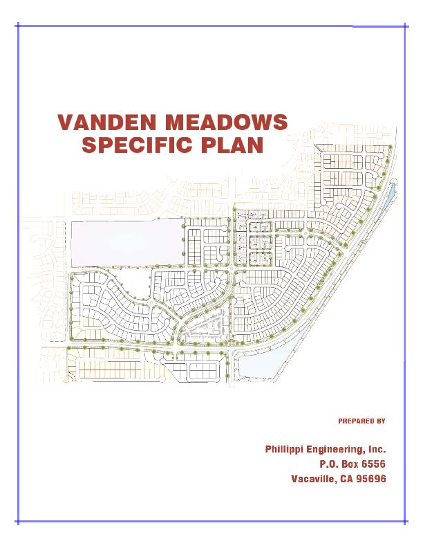
VANDEN MEADOWS SPECIFIC PLAN TABLE OF CONTENTS
|
|
|
- Daisy Turner
- 5 years ago
- Views:
Transcription
1
2 VANDEN MEADOWS SPECIFIC PLAN TABLE OF CONTENTS Chapter 1 Chapter 2 Chapter 3 Chapter 4 Chapter 5 Chapter 6 Chapter 7 Chapter 8 Chapter 9 Introduction Vision and Goals Land Use Transportation and Circulation Parks, Trails and Resource Management Community Design Public Facilities Community Services and Facilities Implementation
3 Index of Figures 1.1 Regional Map 1.2 Vicinity Map 1.3 Vanden Meadows Properties 1.4 Vanden Meadows Satellite Photo 2.1 Vanden Meadows Conceptual Development Plan 3.1 Proposed Land Use 3.2 Proposed Zoning 4.1 Vehicular Circulation System 4.2 Street Network Key Plan Section 1 Leisure Town Road (Jepson Parkway) Section 2 Nut Tree Road Section 3 Foxboro Parkway Section 4A & 4B Vanden Road Section 5 Major Collector Street Section 6 Minor Collector Street Section 7 Residential Street 4.3 Non Vehicular Circulation Diagram 5.1 Park and Trail Diagram 5.2 Street Tree Concept 6.1 Community Entry Features Locations Potable Water Master Plan Non Potable Water Master Plan Sewer Master Plan Off Site Sewer Improvements 7.3 Storm Drain Master Plan 7.4 Dry Utilities Master Plan
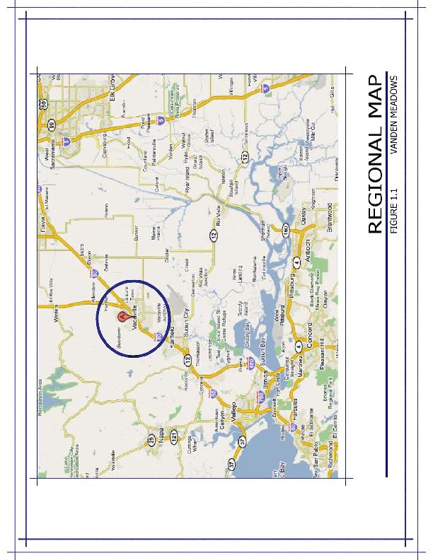
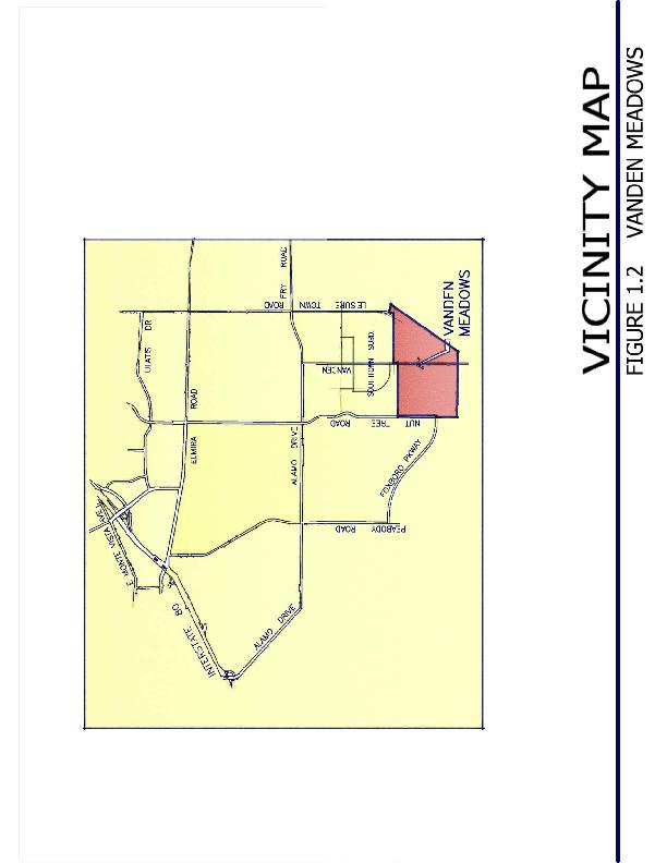
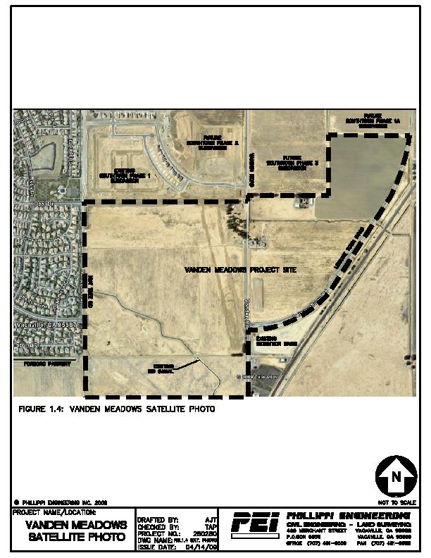
4 1.0 INTRODUCTION 1.1 SUMMARY The primary objective of this Specific Plan is to create development standards and a land use plan for the Vanden Meadows area that will satisfy the overall goals of the City while recognizing and tying into the Southtown Project and its design theme. The total Vanden Meadows area comprises 260 +/ acres and is bounded by Nut Tree Road on the west, the Southtown Project to the north, the railroad property to the east and the Vacaville/ Fairfield buffer to the south. (See Figure 1.1 Regional Map and Figure 1.2 Vicinity Map) The property comprises 5 land owners (See Figure 1.3 Vanden Meadows Properties). Presently the subject properties are vacant and are used mostly for dry farming (See Figure 1.4 Vanden Meadows Satellite Photo). The project is proposed to include the following amenities: Two new schools (Middle School and Elementary School) or one new K 8 School. Foxboro Connection between Nut Tree Road and Leisure Town Road. (While construction of the middle two lanes of this project is the responsibility of the Southtown Project, it is recognized that annexation of the property may be required to effectuate that construction.) Improvements to Leisure Town Road (in conformance with Jepson Parkway Plan). New City Park (adjacent to the new school(s)). Trails throughout the development which also connect to the Southtown trail system. Variety of housing types and densities while maintaining an overall density of / units/ acre, as specified in the General Plan (which designates a range of units/ acre for this area).
5
6
7
8
9 The following describes the prior mentioned amenities and outlines the benefits of annexation into the City of Vacaville: Schools The Travis Unified School District has acquired a 30 +/ acre site in the Vanden Meadows area and identified it as the future site of 1 or possibly 2 schools. The School District is currently conducting studies to determine if they will build a middle school and an elementary school or one K 8 school. The District master plan calls for this school to be built in 3 5 years (approximately ) depending on rate of buildout of the Southtown Project and the Vanden Meadows Project. The school(s) will need City of Vacaville water and sewer services to develop the project which will require annexation into the City of Vacaville Foxboro Parkway The Foxboro Parkway connection from Nut Tree Road to Vanden Road has been identified by the City of Vacaville as a key arterial which will provide an enhanced connection to Leisure Town Road and Vanden Road (the future Jepson Parkway) from the Foxboro development area. Construction of the middle two lanes is a requirement of the Southtown Project. This will be required when Vanden Road is closed for construction of the new Community Park within Southtown. However, obtaining the right of way has proved problematic and condemnation may be required. In order for the City to proceed with condemnation; the property must be within the City limits Improvements to Leisure Town Road (Jepson Parkway) Recently the Solano Transportation Authority (STA) adopted the Jepson Parkway Plan Line a portion of which comprises Leisure Town Road and Vanden Road South of Leisure Town Road. With development of the Vanden Meadows area frontage roadway and landscaping improvements will be constructed along this key corridor serving Fairfield and Vacaville.
10 1.1.4 New City Park Development of the Vanden Meadows area will result in the construction of a new / acre (gross) park adjacent to the proposed school site. The Travis Unified School District has indicated that they would like to have a joint use agreement between the District and the City regarding this park to increase its usability and functionality Trail System In addition to the new park, a series of trails will be constructed throughout the development which will provide a pedestrian friendly connection with the park, the school(s) and with the Southtown Trail system. The Vanden Meadows project will be constructing approximately 4 miles of trails and when combined with the Southtown Trails represents a total of 10.6 miles of interconnected trails. These trails along with the park and landscaping comprise acres of dedicated open space and recreational area Variety of Housing Types The Vanden Meadows development proposes a wide variety of housing types with an emphasis on moderate density development. The City of Vacaville General Plan policies indicate that development in outlying areas construct a minimum of 25% moderate density housing to increase the City s existing moderate density which is currently at 20% +/. The Vanden Meadows development proposes a total of 32.6 % +/ moderate density including a cluster/courtyard development and other small lot single family product. In addition to the moderate density, the Vanden Meadows development will provide 20.5 % +/ high density housing with the inclusion of an apartment site. 1.2 LEGAL CONTEXT Authority to Prepare A Specific Plan is a planning and regulatory tool made available to local governments by the State of California. By law, Specific Plans are intended to implement a city or county s General Plan through the development of policies, programs and regulations that provide an intermediate level of detail between the General Plan and individual development projects. As a
11 mechanism for the implementation of the goals and policies of a City s General Plan, State law stipulates that Specific Plans can only be adopted or amended if they are consistent with the jurisdiction s adopted General Plan. The authority to prepare and adopt Specific Plans and the requirements for its content are set forth in the California Government Code through The law requires that a Specific Plan include text and diagrams that specify: The distribution, location, and extent of the uses of land, including open space, within the area covered by the plan. The proposed distribution, location, and extent and intensity of major components of public and private transportation, sewage, water, drainage, solid waste disposal, energy, and other essential facilities proposed to be located within the area covered by the plan and needed to support the land uses described in the plan. Standards and criteria by which development will proceed, and standards for the conservation, development, and utilization of natural resources, where applicable. A program of implementation measures including regulations, programs, public works projects, and financing measures necessary to carry out the items listed above Relationship to the General Plan The Vanden Meadows Specific Plan and the City s General Plan provide a framework to guide future land use and development decisions within the 260 +/ acre planning area. The Specific Plan is consistent with, and functions as an implementation tool of the General Plan in three ways: A) By acting as a statement of planning policy that refines the general plan policies applicable to a specific plan area; B) By directly regulating land use and; C) By bringing together detailed policies and regulations into a focused development program. The City s General Plan Land Use Element, as updated, has two specific Implementing Policies (2.3 I 12 & 2.3 I 13) for the Vanden Meadows area. (The General Plan refers to this area as the South Vanden Area.) The
12 Implementing Policies are italicized as follows along with how the Vanden Meadows Specific Plan addresses each statement highlighted with bold font: 2.3 I 12: In the portion of the Vanden Specific Plan area south of Foxboro Parkway and west of Vanden Road, the minimum lot size shall be 10,000 square feet. As required by this policy, the minimum lot size south of Foxboro Parkway is designated 10,000 SF. 2.3 I 13: Require that the South Vanden Area, including the Southtown and Moody Project Areas, facilitate the development of a range of housing densities and opportunities, pedestrian and bicycle friendly design, neighborhood commercial sites, and recreational and neighborhood facilities, by including the following requirements: A network of landscaped pedestrian/bike corridors that connect key elements of the area, such as the regional park and arterial streets. This is provided for in the Vanden Meadows Specific Plan. New development adjacent to existing homes within the City limits shall match or exceed the size, character, and quality of adjacent homes and lots. This is provided for in the Vanden Meadows Specific Plan. All new residential development shall conform with the Residential Design Requirements for New Single Family Development. This is provided for in the Vanden Meadows Specific Plan. The Southtown project area will include a range of housing types and densities, attached, detached, and cluster housing. This is provided for in the Vanden Meadows Specific Plan. Land shall be reserved for community uses such as private schools, membership organization, day care centers, and senior centers. Land has been reserved for 2 public schools a large neighborhood park and numerous trails. A financing mechanism for all public facility improvements shall be established before development occurs.
13 The Southtown Benefit District has been established for this area which ensures that each project will pay for its fair share of public facility improvements. Nut Tree Road and Vanden Road shall be widened to the City standard width through the project sites for all projects that front on these streets. These street widenings will be done with the Vanden Meadows development. It should be noted that in response to concerns expressed by the Traffic Department, development of the Vanden Meadows area will result in a realignment of Vanden so that is does not intersect with the Foxboro Parkway/Leisure Town Road intersection. This realignment will significantly improve the Traffic Level of Service (LOS) at the Foxboro/Leisure Town Road/Vanden Road (south) intersection. Leisure Town Road shall be widened and improved to the standards for the Jepson Parkway along the frontage of all projects that abut to Leisure Town Road. These street widenings will be done with the Vanden Meadows development. Foxboro Parkway shall be extended between Nut Tree Road and Vanden Road. The extension will be completed prior to the reconstruction and reconfiguration of Vanden Road. This is a requirement of the Southtown Phase 3 project. Different development projects within the South Vanden Area shall coordinate their respective roads, bike paths, landscape corridors and design standards to create a unified sense of place and identity. Roads, trails, landscape corridors are coordinated with the Southtown Project to provide continuity between the projects. Commercial buildings shall be no more than an average of 30 feet in height, and be designed to front on the sidewalk, with parking at the rear of the property, when feasible, so as to enhance neighborhood aesthetics and to encourage pedestrian friendly design. No commercial buildings are anticipated in the Vanden Meadows area.
14 Infrastructure master plans for sewer, water, storm drain, and traffic improvements shall be prepared prior to or in conjunction with the processing of subdivision maps for all development within the South Vanden areas, including the Southtown and Moody Project Areas. Master plans for sewer, water, storm drainage and traffic improvements were created for the South Vanden Area as part of the Southtown Project which included development of the Vanden Meadows area. Prior to the approval of any subdivision applications, the developers shall assure that all required domestic water supply and distribution systems, wastewater collection and treatment facilities, storm water management facilities, and roadway segment and intersection improvements will be incorporated into the final project plans. The Vanden Meadows Project will incorporate the infrastructure as outlined in the master plans mentioned previously. The lands to the south of the Southtown and the Moody Project Area will be subject to subsequent General Plan Amendments; Prezonings, and other prerequisites to annexation. As the Vanden Meadows Specific Plan proposals are in compliance with the policies in the City General Plan it is not anticipated that a General Plan Amendment will be required. Applications for development will include this Specific Plan, Prezoning, Pre Tentative Maps, and Annexation Purpose and Intent The Specific Plan provides both general guidelines and specific standards for the development of Vanden Meadows and sets the parameters for a variety of land uses; thus the purpose of the Specific Plan is to provide a set of plans, policies, regulation and implementation programs for guiding and ensuring orderly, future development in accordance with the adopted Land Use Plan within the General Plan.
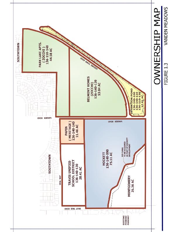
15 1.2.4 Environmental Review The adoption of a Specific Plan is a project under the California Environmental Quality Act (CEQA) and the CEQA Guidelines. To meet CEQA requirements, a Mitigated Negative Declaration will be prepared as part of the process in adopting this Specific Plan Development Agreement It is anticipated that, as part of the project approval process, a Development Agreement (DA) will be entered into between project proponents and the City of Vacaville. The DA will address such issues as the Community Benefit Contribution (CBC) and the Planned Growth Ordinance (PGO); therefore, those issues will not be discussed within the Specific Plan. 1.3 PLANNING CONTEXT Regional Context The Specific Plan area is located in northern Solano County, in the southeastern corner of the City of Vacaville, as shown in the Vicinity Map in Figure 1.2. Vacaville is at the midpoint between San Francisco and Sacramento along Interstate 80, the major transportation link between these two growing urban areas as shown on the Regional Map Figure Site Context Project Area Description The Vanden Meadows area comprises 260 +/ acres and is bounded by Nut Tree Road on the west, the Southtown Project to the north, the railroad property to the east and the Vacaville/ Fairfield buffer to the south. (See Figure 1.2 Vicinity Map) The property comprises 5 land owners, (See Figure 1.3 Vanden Meadows Ownership Map). Presently, the subject properties are vacant and used mostly for dry farming (See Figure 1.4 Satellite Photo of the area) Property Ownership Property Owners within the Vanden Meadows Specific Plan Area (with Assessors Parcel Numbers (APN) and property acreage) are listed in Table 1.1.
16 Table 1.1 Parcels and Ownership APN Owner Acres City of Vacaville Park Lane Apartments SID Thomas Montgomery Roy Hockett City of Vacaville City of Vacaville Belmont Homes Travis Unified School District Evon Papin See Figure 1.3 for a graphical depiction of the parcels noted above.
17 2.0 VISION AND GOALS 2.1 PROJECT VISION The Vanden Meadows Project proposes to tie into the theme and character developed with the Southtown Project. Southtown was developed with a central park as its focal point with trails and landscaping corridors radiating out from that central core. Vanden Meadows continues that theme with numerous trails that tie into the Southtown Trail system while also tying into the Vanden Meadows Park and school(s) (See Figure 2.1 Vanden Meadows Conceptual Development Plan). Vanden Meadows would also provide for either a K 8 school or both an elementary school and a middle school campus. This school(s) would be adjacent to a proposed City park, creating a second major focal point in the Southtown/ Vanden Meadows area. Much like Southtown, with trails radiating out from the central core, Vanden Meadows will also have trails radiating out from the school(s)/park to tie into the rest of the community. Vanden Meadows provides for a diverse residential project with densities ranging from low density to high density with individual unique neighborhoods interconnected into a sustainable planned community. Policies and statements in the City of Vacaville General Plan indicate a strong desire to have more moderate density housing ( units/acre) in the outlying areas. To that end, Vanden Meadows proposes that 32.6 % +/ of the residential units will be moderate density housing. This moderate density housing would comprise a medium density cluster/courtyard style area and an area of low medium density small lot single family residential. These residential products fit within the moderate density category as specified in the General Plan. While focusing on providing a greater percentage of moderate density housing, the overall density still complies with the General Plan designation for this area. The proposed overall density is 4.6 +/ units per acre, which is in compliance with the designation for this area of units per acre.

18 FIGURE 2.1 Vanden Meadows Conceptual Development Plan
19 2.1.1 Significant Public Benefits There are numerous Public Benefits that will occur with the development of the Vanden Meadows area. These benefits are as follows: Schools The Travis Unified School District has acquired a 30 +/ acre site in the Vanden Meadows area and identified it as the future site of 1 or possibly 2 schools. The School District is currently conducting studies to determine if they will build a middle school and an elementary school or one K 8 school. The School District master plan calls for this school to be built in 3 5 years (approximately ), depending on the rate of buildout of the Southtown Project and the Vanden Meadows Project Foxboro Parkway The Foxboro Parkway connection from Nut Tree Road to Vanden Road has been identified by the City of Vacaville as a key arterial which will provide an enhanced connection to Leisure Town Road and Vanden Road (the future Jepson Parkway) from the Foxboro development area. Construction of the middle two lanes is a requirement of the Southtown Project when Vanden Road is closed for construction of the new Community Park. Annexation and development along the future alignment of Foxboro Parkway will allow for completion of this vital 4 lane connection Improvements to Leisure Town Road (Jepson Parkway) Recently the Solano Transportation Authority (STA) adopted the Jepson Parkway Plan Line which comprises Leisure Town Road and Vanden Road South of Leisure Town Road. With development of the Vanden Meadows area frontage roadway and landscaping improvements will be constructed along this key corridor serving Fairfield and Vacaville City Park Development of the Vanden Meadows area will result in the construction of a new 6+ (net) 7.38 (gross) acre park adjacent to the proposed school site. This park size exceeds the City standard for neighborhood parks in that 1.8 acres of neighborhood park per 1,000 residents is required which
20 would result in only 5.0 acres of park instead of the proposed 6+ acres. The Travis Unified School District has indicated that they would like to have a joint use agreement between the District and the City regarding this park to increase its usability and functionality Trails In addition to the new park, a series of trails will be constructed throughout the development which will provide a pedestrian friendly connection with the park, the school(s) and with the Southtown trail system. The Vanden Meadows project will be constructing approximately 4 miles of trails and when combined with the Southtown trails, represents a total of 10.6 miles of interconnected trails. These trails along with the park and landscaping comprise acres of dedicated open space and recreational area Variety of Housing Types The Vanden Meadows development proposes a wide variety of housing types with an emphasis on moderate density development. The City of Vacaville General Plan policies indicate that development in outlying areas construct a minimum of 25% moderate density housing to increase the City s existing moderate density which is currently at 20% +/. The Vanden Meadows development proposes a total of 32.6 % +/ moderate density including a cluster development and other small lot single family product. In addition to the moderate density the Vanden Meadows development will provide 20.5 % +/ high density housing with the inclusion of an apartment site Recreation With the construction of the park and trail system, Vanden Meadows will provide unique opportunities for walking, running and biking. Play areas will be much larger than traditional parks because the park area will be combined with the school(s) play areas to provide an expansive recreational area.
21 2.1.3 Housing As mentioned previously, the vision of the Vanden Meadows development is to provide a variety of housing with a stronger emphasis on moderate housing Superior Quality The Vanden Meadows vision is a superior quality community focused on school(s), parks, and trails tying into the superior quality of the Southtown development Connectivity The Vanden Meadows layout will provide excellent pedestrian and biking connectivity to the Southtown Park, Cannon Station Park, and the new Vanden Meadows Park. In addition, the completion of Foxboro Parkway will improve access to Leisure Town Road (Future Jepson Parkway) and Vanden Road, which will significantly improve access to Interstate 80 and Travis Air Force Base from the Southeast Vacaville Civic and Public Benefits The Civic and public benefits have been enumerated in several other locations within this Specific Plan. Succinctly, the civic and public benefits include the school(s)/park, Foxboro Parkway, improvements to Leisure Town Road (Jepson Parkway), and numerous trails History There is little in the way of development history regarding this area. However, preparations for development of the Vanden Meadows area have been in the making since 2004, which is when the EIR was prepared for the Southtown Project. Within that EIR, much of the anticipated impacts from the Vanden Meadows development were examined. Also in 2004, the property was included in the near term annexation area (3 5 years) within the City of Vacaville Comprehensive Annexation Plan (CAP). This year, 2009, is at the end of this anticipated timeline. In 2008 the City of Vacaville established the Southeast Vanden Benefit District which included this area. The Benefit District established the fair
22 share of costs attributable to Vanden Meadows for the infrastructure installed for the Southtown Project which was sized to accommodate the Vanden Meadows Development Environment and Sustainability The Vanden Meadows Development proposes a park and trail system which will enhance recreational opportunities for the residents of the area while also enhancing the open space feel and visual amenities. 2.2 LAND USE CONCEPTS The land use concept for the 260 +/ acre Vanden Meadows development is a mix of residential uses complemented by the proximity to school(s), park and trails. The Vanden Meadows Specific Plan includes the following Land Use Goals: 1. Goal: Provide for a quality project by use of high standards for design of the homes, landscaping, streetscape, and public amenities. 2. Goal: Include a variety of housing types, including an emphasis on moderate density housing (particularly small lot single family residential) that is in compliance with the goals and policies of the Vacaville General Plan. The overall density has been established at 4.6+/ units/ acre. This 4.6 +/ units/acre density is in compliance with the General Plan range designated for the area of units/ acre. Further, Vanden Meadows will provide for a minimum of 20% +/ high density residential to augment the 32.6 % +/ moderate density residential. 3. Goal: Provide a comprehensive system of trails, park and back up landscaping which will comprise a total of 30 +/ acres. 2.3 HOUSING GOALS Incorporated in the Vanden Meadows design are numerous design principles that foster community place making, and therefore the Housing Goals of the Vanden Meadows Development are:
23 1. Goal: Create walkable neighborhoods with interconnected streets and trails that encourage pedestrian activity. 2. Goal: Construct a neighborhood park which connects to the trails and is adjacent to the school(s). 3. Goal: Construct a neighborhood school(s) serving 2000 students. 4. Goal: Provide a high variety of house plan types and exterior configurations with various options and styles. 2.4 OPEN SPACE GOALS Goal: Plan a system of street and trail connections that link key elements (school(s), park, and trails) with the key elements of the Southtown Project (Community center/park, fire station, and trails). 2.5 OTHER GOALS The Vanden Meadows Specific Plan goals for land use and design, circulation, resource management, public utilities and services can be found in their respective chapters: Chapter 3 Land Use Chapter 4 Transportation and Circulation Chapter 5 Recreation, Open Space and Resource Management Chapter 6 Community Design Chapter 7 Public Facilities Chapter 8 Community Services and Facilities
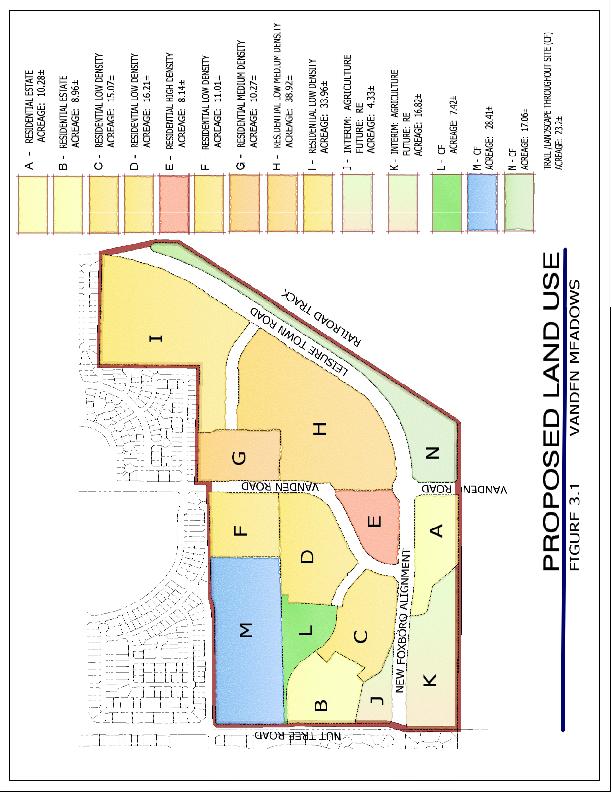
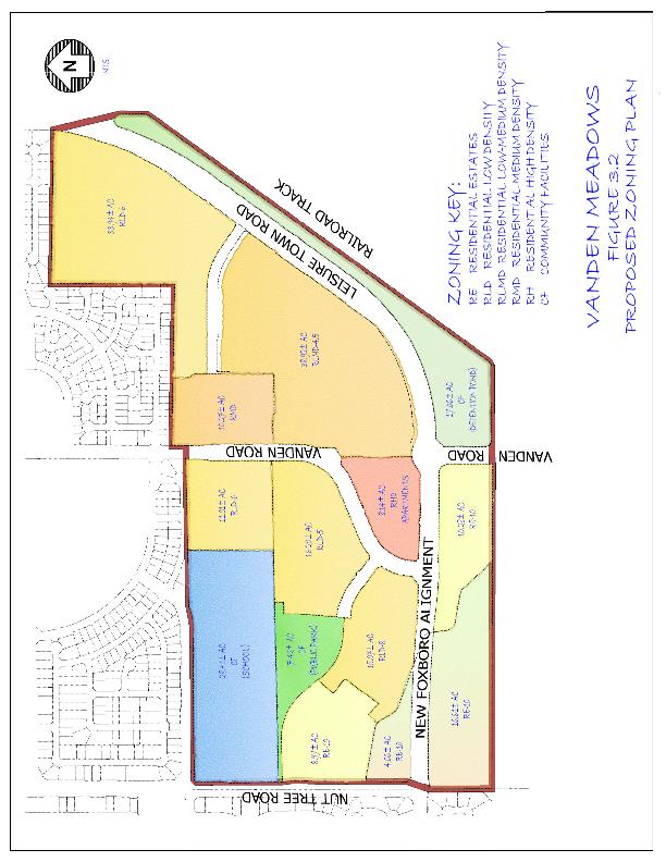
24 3.0 LAND USE 3.1 INTRODUCTION The Vanden Meadows Specific Plan establishes a comprehensively planned community that is designed to work with the Southtown project to the north. The Land Use component of the Specific Plan is primarily residential with the non residential uses comprising the school(s) and park. 3.2 LAND USE GOAL Goal: To establish an attractive community that provides a variety of residential and recreational opportunities. 3.3 THE DEVELOPMENT PLAN Vanden Meadows is a planned community that is designed to integrate residential opportunities, with school(s), park, trails, and the Southtown and Foxboro Community Facilities. 3.4 PLANNING SUBAREAS The Vanden Meadows area is divided into 13 Subareas (See Figures 3.1 and 3.2). Each subarea has a different land use designation. Table 3.1 details each of the subareas. Subareas A, B, C, D, and E are owned by the Hockett group. This property is located between Nut Tree Road and Vanden Road with the Travis Unified School District (TUSD) property comprising a portion of its northern boundary and the Montgomery property, SID canal, and Fairfield Vacaville buffer comprising its southern boundary. Subarea F is owned by Evon Papin and the property is bounded by Southtown to the north, the TUSD property to the west, Vanden Road to the east and the Hockett property to the south. Subareas G, H, and I are owned by Belmont Homes and Park Lane Apartments (collectively referred to as Zocchi Property) and are bounded by Southtown to the north, Vanden Road to the west and Leisure Town Road (Jepson Parkway) to the east and south.
25 Subareas J and K are owned by the Montgomery group and is bounded by the Fairfield Vacaville buffer to the south, Nut Tree Road to the west, and the Hockett property to the north and east. Subarea L is designated as a future park and is currently owned by the Hockett group. Subarea M is owned by the Travis Unified School District and is designated for future school(s). Subarea N is currently owned by various entities and is designated as trails, landscaping and agricultural buffer. Lastly, Subarea O is designated as Detention Basin (Community Facility). TABLE 3.1 VANDEN MEADOWS LAND USE SUMMARY (Refer to Figures 3.1 and 3.2 for Location of Areas) Sub Area Land Use Proposed Zoning Approximate Area (Acres) Residential Units A RE RE B RE RE C RLD RLD D RLD RLD E RHD RH F RLD RLD G RMD RMD H RLMD RLMD I RLD RLD J RE RE K RE RE Density (Units/Acre) L CF CF 7.42 PARK Non Residential Uses M CF CF SCHOOL TRAILS & N CF CF LANDSCAPING (including AG Buffer) O CF CF DETENTION BASIN TOTAL * * Total Land Use Density Excludes the School Property (28.41 Ac), the Ag Buffer (6.93 Ac), and the Detention Basin (17.01 Ac).
26
27
28 3.5 RESIDENTIAL ELEMENT GOALS The Vanden Meadows Specific Plan Residential Element Goals are as follows: 1. Goal: Create a unique residential environment that complements and ties into the Southtown Project. 2. Goal: Encourage a range of housing types with an emphasis on single family moderate density development while addressing the policies and goals in the City of Vacaville General Plan. 3. Goal: Ensure that each neighborhood has direct access to the interconnected trail system. The policies in the Vacaville General Plan discuss the desire to increase the amount of moderate density housing within the City. Specifically those policies require that new outlying areas of the City have a minimum of 25% moderate density residential. Moderate Density, per the General plan, comprises the Land Uses of: Residential Low Medium Density and Residential Medium Density. The proposed residential breakdown for the Vanden Meadows development is listed in Table 3.2. TABLE 3.2 VANDEN MEADOWS RESIDENTIAL LAND USE SUMMARY Land Use Approximate Area (Acres) Residential Units Percentages LOW RE % DENSITY RLD % Total Percentages 46.96% MODERATE RLMD % DENSITY RMD % 32.59% HIGH DENSITY RHD % 20.45% TOTALS * % 100.0% * Acreage excludes public facilities, detention basin, school(s), and agricultural buffer Site Uses Vanden Meadows is a residential development and as such, the Permitted Uses, Conditional Uses and Prohibited Uses will be identical to those listed in the City of Vacaville Land Use and Development code (latest edition) for the various residential zone districts.
29 3.5.2 Density Standards Density ranges for the various residential zone districts shall comply with the City of Vacaville Land Use and Development Code with the exception of the land use Residential Estates, which may have a minimum density of 2.5 units per acre. Floor area ratios shall comply with the City of Vacaville Land Use and Development Code except as noted in Table 3.3. TABLE 3.3 EXCEPTIONS TO MAXIMUM COVERAGE Zoning District Density Maximum Coverage RLD RLMD RMD Building Standards The standards for building height and front, rear and side yard setbacks shall comply with the City of Vacaville Land Use and Development Code except as noted in Table 3.4. TABLE 3.4 EXCEPTIONS TO BUILDING STANDARDS Zoning District Density Minimum Front Yard to Habitable Space Minimum Side Yard Minimum Rear Yard Minimum Distance Between Structures RLD ** 5 & 10 * RLMD ** 5 & RMD ** 5 & * Footnote 5 of the Land Use and Development Code does not apply. ** On corner lots the minimum setback from the angled corner shall be 10.
30 3.5.4 Parking Standards Parking shall be provided in accordance with City of Vacaville Land Use and Development Code, Chapter Other Development Standards For Development Standards not specifically mentioned in this Specific Plan, refer to Chapter Zoning in the City of Vacaville Land Use and Development Code Design Criteria Individual dwelling units shall be of high quality and subject to review and approval by the Planning Commission.
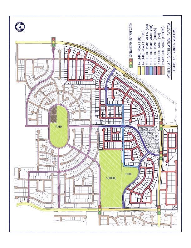
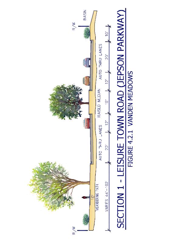
31 4.0 TRANSPORTATION AND CIRCULATION 4.1 INTRODUCTION Goal: Provide a circulation system which maintains and improves access and connectivity between and within Vanden Meadows and Southtown. 4.2 EXISTING SETTING Vanden Meadows is bounded by Leisure Town Road on the east, Nut Tree Road on the west, the Southtown Development to the north and the Vacaville Fairfield buffer to the south. The existing roadways and the proposed vehicular circulation system through the Specific Plan area are shown on Figures 4.1 and 4.2 and include the following: Leisure Town Road (future Jepson Parkway) Currently Leisure Town Road is a two lane rural road bordering the eastern portion of the area. Future plans call for this road to be redesignated as Jepson Parkway and will be a four lane arterial with large landscaped frontages. The developers of Vanden Meadows will be responsible for construction of the fronting curb, gutter, sidewalk, 20 feet of pavement and the landscaping per the Jepson Parkway plan line as recently approved by the Solano Transportation Authority (STA). See Figure 4.2 for the location and Figure Leisure Town Road (Jepson Parkway) for the details of the proposed street section Nut Tree Road Nut Tree Road borders the Vanden Meadows development on the west. Currently the road is two lanes but is designated to be a four lane arterial with buildout of the area. The western portion of Nut Tree Road was completed with the Foxboro development and the developers of the Vanden Meadows area will be responsible for completing the required final improvements (including the landscaping and trails) to Nut Tree Road. See
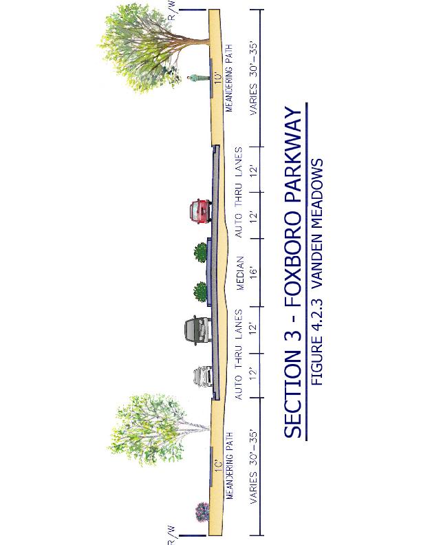
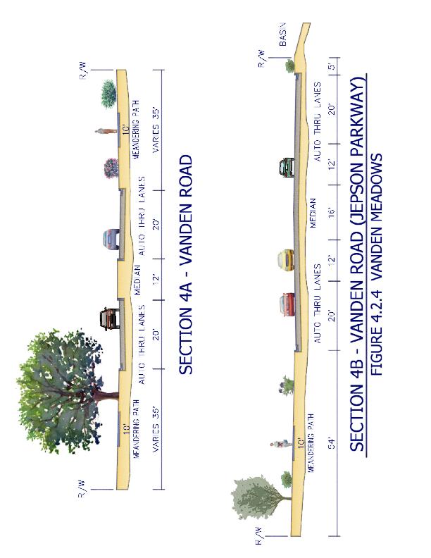
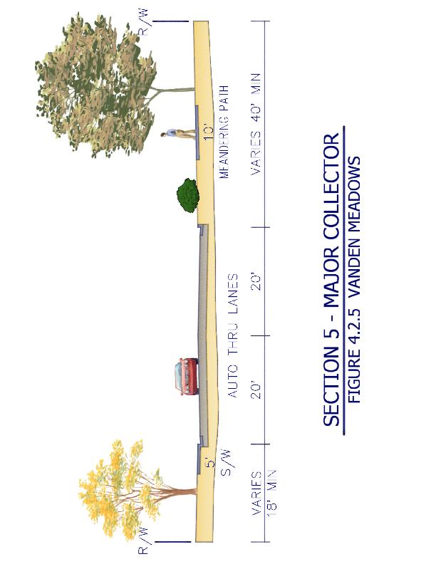
32 Figure 4.2 for the location and Figure Nut Tree Road for the details of the proposed street section Foxboro Parkway Currently, Foxboro Parkway is a four lane arterial within the Foxboro development that terminates at Nut Tree Road. The City of Vacaville General Plan requires that this four lane parkway be continued from Nut Tree Road to the intersection of Leisure Town Road at Vanden Road. This connection will greatly improve circulation in the southeast Vanden area and will provide connectivity to Travis Air Force Base to the south as well as Interstate 80 to the north for those residents within the Foxboro development. Completion of the parkway improvements (including trails and landscaping) is the joint obligation of the Southtown developers and the Vanden Meadows developers. See Figure 4.2 for the location and Figure Foxboro Parkway for the details of the proposed street section Vanden Road Currently Vanden Road is a two lane rural road which will be improved to collector standards with a landscaped median for that portion of the road north of Leisure Town Road. In order to improve traffic flow for the future Jepson Parkway, Vanden Road will be realigned to intersect Foxboro Parkway west of the Foxboro/Leisure Town Road (Jepson Parkway) intersection. This portion of the Vanden Road, including landscaping and trails, will be completed with development of Vanden Meadows. Vanden Road south of Leisure Town Road will be designated Jepson Parkway and the Vanden Meadows development will be responsible for completing the frontage improvements (curb, gutter, sidewalk, some pavement and landscaping). The balance of improvements will be completed through traffic impact fees and STA grants. See Figure 4.2 for the location and Figure Vanden Road for the details of the proposed street section Major and Minor Collector Streets with Trail Within the Vanden Meadows development there are two street sections that are designated Major Collector Streets and two street sections that are designated Minor Collector Streets.
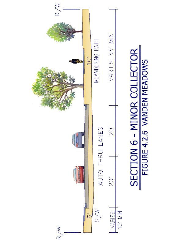
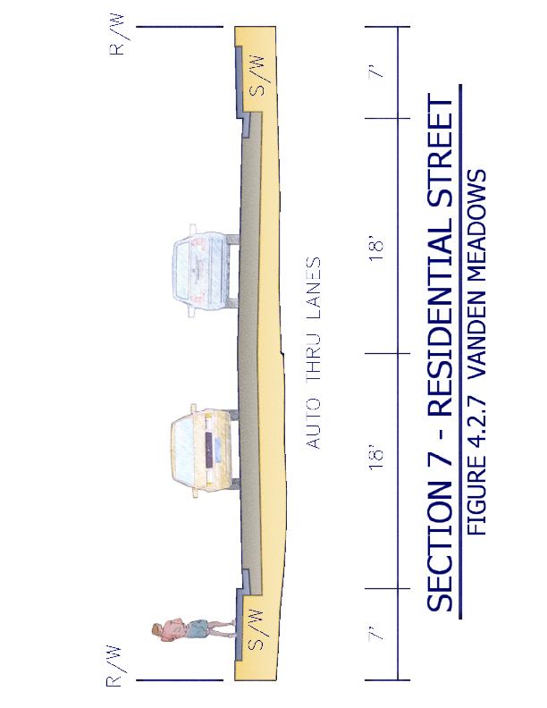
33 Major Collector Streets are collectors (40 feet wide) with trails on both sides of the street and with no residential units fronting on the street. See Figure 4.2 for the location and Figure Major Collector Street for the details of the proposed street section. Minor Collector Streets are collectors (40 feet wide) with trails on one side of the street and some residential units fronting on the street. See Figure 4.2 for the location and Figure Minor Collector Streets for details of the proposed street section Residential Streets All other streets not mentioned above will be designated as residential streets. These streets will comply with the City of Vacaville standards for residential streets. See Figure 4.2 for the location and Figure Residential Street for details of the proposed street section. 4.3 CONNECTIONS Completion of the street network within the Vanden Meadows area will provide a significant improvement in vehicular circulation throughout the southeast portion of Vacaville. The Foxboro Parkway connection will provide ease of movement from Southeast Vacaville to Travis Air Force Base and to Interstate 80. In addition, this connection will provide for a direct connection to Peabody Road from the southeast Vacaville area. The completion of Jepson Parkway as envisioned by the STA will provide enhanced connections between Suisun City, Fairfield, Vacaville and Dixon. 4.4 VEHICULAR STREET NETWORK The following are implementing policies to ensure completion of the Vehicular Street Network as envisioned by this Specific Plan. 4.4 P 1 The density of the residential development shall not generate traffic volumes that exceed the capacity (LOS D) of the Foxboro Parkway, Vanden Road, and Jepson Parkway Intersections.
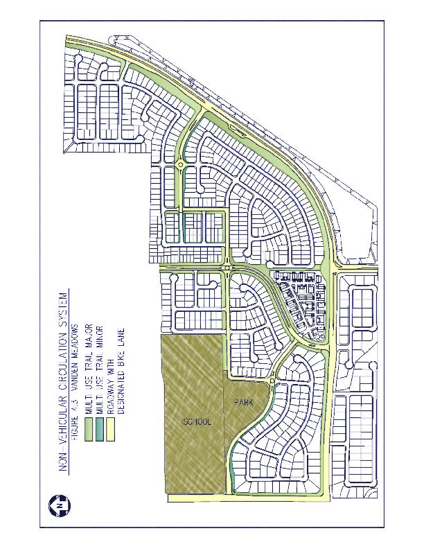
34 4.4 P 2 The LOS throughout the remainder of the Vanden Meadows area shall comply with the City s Traffic Mitigation Policy of not exceeding LOS C. 4.4 P 3 The City will require the Master Developer to enter into a Development Agreement to provide the necessary roadway improvements to serve the development and mitigate related traffic impacts. 4.4 P 4 Specific Plan developers shall fund circulation improvements necessitated by the Specific Plan development through various funding mechanisms (i.e. assessment districts, traffic impact fees, private funding, etc.). 4.4 P 5 The public road rights of way and street improvements shall comply with City of Vacaville standards and said rights of way will be dedicated to the City of Vacaville as public streets as shown in the following Figures: Section 1 Leisure Town Road (Jepson Parkway) Section 2 Nut Tree Road Section 3 Foxboro Parkway Section 4A & 4B Vanden Road Section 5 Major Collector Street Section 6 Minor Collector Street Section 7 Residential Street 4.5 NON VEHICULAR CIRCULATION NETWORK Goal: Develop a comprehensive bikeway/ pedestrian system that connect the park, school(s), and Southtown development, and promote the use of alternatives to driving. 4.5 P 1 Construct the trail/bike system as shown in Figure 4.3 Non Vehicular Circulation Diagram.
35 4.5 P 2 Construct a vehicular parking facility on Leisure Town Road to allow for those outside the Vanden Meadows area to utilize the trail/bike system. 4.6 TRANSIT Goal: Promote increased local transit ridership and provide Specific Plan area residents with the opportunity to use public transportation as an alternative to driving. Transit service in Vacaville is provided by Vacaville City Coach through a fixed route and dial a ride services. City Coach services are coordinated with other area transit services for weekday peak hour commute service along Interstates 80 and 680 corridors. This includes services from the Fairfield/Suisun Transit and Vallejo Transit systems with routes that connect to BART stations in Pleasant Hill and El Cerrito. The following are implementing policies to meet the stated goal: 4.6 P 1 Currently, Route 8 travels through the Foxboro area along Youngsdale Drive to Nut Tree Road and then heads north. The City may wish to consider extending Route 8 farther south into the Vanden Meadows area. 4.6 P 2 If the City desires to expand Route 8 (or any other route for that matter) into Vanden Meadows the developers of Vanden Meadows shall install bus turnouts and transit stops in location(s) designated by the City.
36
37
38
39
40
41
42
43
44
45
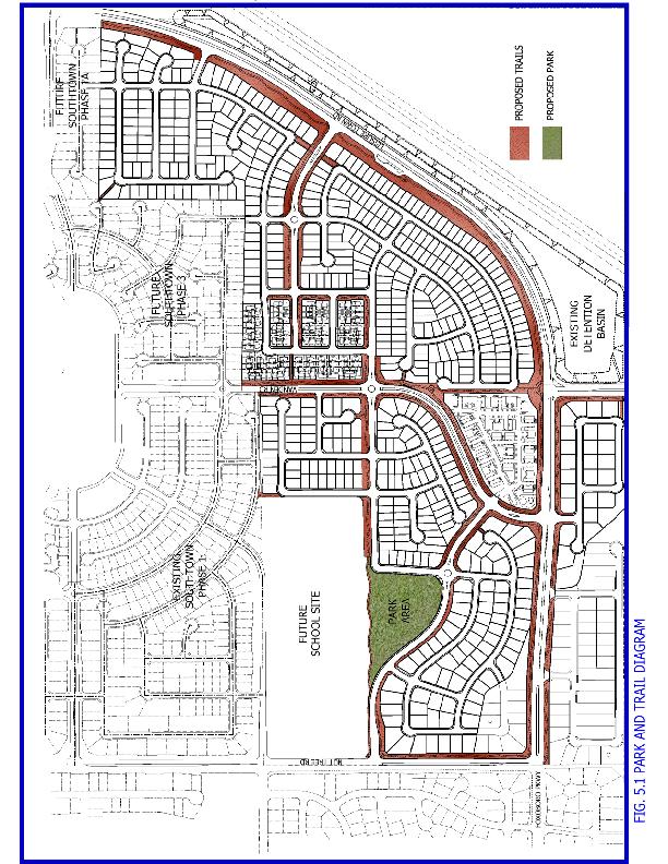
46 5.0 RECREATION, OPEN SPACE AND RESOURCE MANAGEMENT 5.1 INTRODUCTION 1. Goal: To protect and enhance existing biological resources. 2. Goal: To provide a development that is compatible with the Agricultural uses to the east. Currently a biological assessment is underway which will ascertain the existing biological resources, if any. Specific mitigations will be proposed if any endangered species or wetland features are impacted by the Vanden Meadows development. The Vanden Meadows Specific Plan calls for a 500 foot buffer between the proposed residential and the existing agricultural uses east of the railroad track. This 500 foot buffer results in a large landscaped area on the west side of Leisure Town Road. With this buffer in place agricultural uses will not be impacted by the proposed project. 5.1 P 1 The area within the 500 foot buffer, west of the existing Leisure Town Road right of way, will be dedicated to the City of Vacaville as backup landscaping for Leisure Town Road with maintenance paid for by the residents of Vanden Meadows through the use of a Lighting and Landscape District (LLD). 5.2 PUBLIC OPEN SPACE AND RECREATION As mentioned in Section 2; development of the Vanden Meadows area will result in the construction of a new 6+ acre park adjacent to the proposed school site. The Travis Unified School District has indicated that they would like to have a joint use agreement between the District and the City regarding this park to increase its usability and functionality. In addition to the new park, a series of trails will be constructed throughout the development which will connect with the park, the school(s) and with the Southtown trail system. The Vanden Meadows project will be constructing approximately 4 miles of trails and when combined with the Southtown
47 trails represent a total of 10.6 miles of interconnected trails. In addition, these trails along with the park and landscaping comprise acres within the Vanden Meadows area of dedicated open space and recreational area P 1 The park, trails, and backup landscaping will be designed to enhance the Vanden Meadows development area. High quality material will be used along with drought tolerate plants in conformance with the City of Vacaville landscape ordinance. The park, trails and back up landscaping will be dedicated to the City of Vacaville as public amenities with maintenance paid for by the residents of Vanden Meadows through the use of a LLD.
48
49
50 6.0 COMMUNITY DESIGN 6.1 INTRODUCTION Goal: Create and ensure a successful walkable community which interconnects with the Southtown project to the north. 6.2 PURPOSE AND INTENT 6.2 P 1 Create an attractive residential setting that compliments surrounding residential development to the north and west and the agricultural uses to the east and south. 6.2 P 2 Create a suitable buffer between the Vanden Meadows development and the agricultural uses to the east. 6.2 P 3 Provide design guidelines to ensure that Vanden Meadows is an attractive setting for Vacaville residents. 6.3 COMMUNITY DESIGN THEME: LIVABLE NEIGHBORHOODS The intent of the Vanden Meadows development is to create neighborhoods that families can afford. To that end the development encourages a variety of housing types including small single family homes on small lots. 6.3 P 1 House design and materials are intended to be of high quality while recognizing the need to keep homes affordable. The choice of materials, colors and detailing shall be thoughtfully integrated into the design. 6.3 P 2 Neighborhoods should be created with similar design themes and elements to create strong neighborhood identities.
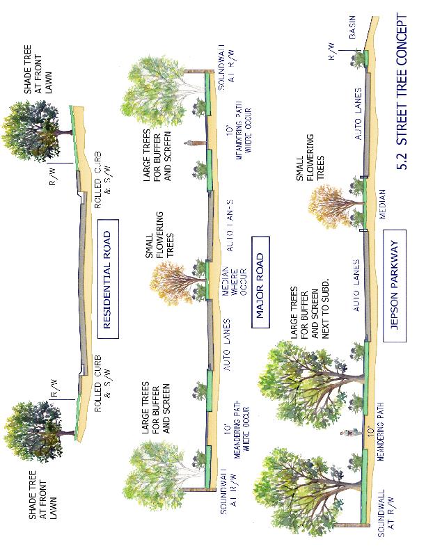
51
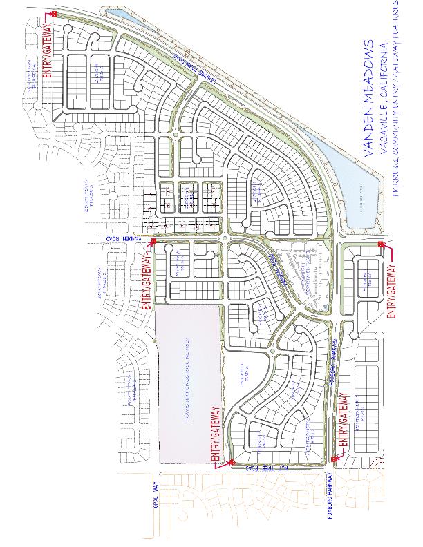
52 6.4 BUILDING FORM The houses should be designed creating a sense of variety. This can be accomplished by utilizing both one and two story elements on the same building and by varying roof plans. In general the community s architecture should create a pedestrian friendly street experience, create neighborhood identity and recognize the need for more affordable living. 6.4 P 1 There should be a wide range of product types incorporated into the various neighborhoods. 6.4 P 2 Garage doors should not become the dominant element of the front elevation. Relief should be achieved by recessing doors and by varying the garage orientation (recessed, swing in, side street access, etc.). 6.5 STREETSCAPE CHARACTER Streets will be planted with approved street trees and enhanced streetscape landscaping as defined in subsequent submittals. Streetscapes should reflect the identity of the roadway system. Taller more imposing trees and widened (20 35 ) landscape strips should define the arterials and major collectors. Medium sized trees and smaller (5 20 ) landscape strips should articulate the minor collectors. In general street trees should be used consistently on residential streets to establish attractive neighborhoods. 6.6 ENTRY FEATURES Entry features should be located at five key locations on the exterior of the Vanden Meadows development area (in each case the developer closest to the designated feature will be responsible for its construction). Refer to Figure 6.1 Community Entry Features Locations: 1. On the west side of Leisure Town Road (facing south bound traffic) at the northern edge of the development area. 2. On the west side of Vanden Road (facing south bound traffic) at the northern edge of the development area.
53 3. On the east side of Nut Tree Road (facing sound bound traffic) at the northern edge of the development area. 4. On the west side of Vanden Road (facing north bound traffic) at the southern edge of the development area. 5. On the south side of Foxboro Parkway (facing east bound traffic) at the western edge of the development area. 6.6 P 1 The developers of the Vanden Meadows project will design and install entry features at the locations designated above. The design will include high quality elements that comply with the City of Vacaville Gateway ordinance. The design for the first entry feature will be used for subsequent features. 6.7 NEIGHBORHOOD SCHOOL The Travis Unified School District has acquired a 30 +/ acre site in the Vanden Meadows area and has identified it as the future site of 1 or possibly 2 schools. The District is currently conducting studies to determine if they will build a middle school and an elementary school or one K 8 school. The District Master Plan calls for this school(s) to be built in 3 5 years (approximately ) depending on the rate of buildout of the Southtown Project and the Vanden Meadows Project. The schools(s) will need City of Vacaville water and sewer services to develop the project which will require annexation into the City of Vacaville. The existing Opal Way has been designed and constructed with the expectation that it would serve as an access for one of the school sites. Further, the City of Vacaville is planning to install a traffic signal at the intersection of Opal Way and Nut Tree Road to provide traffic control once the school is in operation. The Travis Unified School District, with input from the City of Vacaville and the developers of the Vanden Meadows project, will design and construct a school that is in keeping with the character of the Vanden Meadows development area to serve the needs of the residents of the Southeast Vanden area.
54 7.0 PUBLIC FACILITIES 7.1 INTRODUCTION This section of the Specific Plan provides both general and specific guidelines for the development of future infrastructure facilities necessary to serve the Vanden Meadows development area. The infrastructure facilities covered in this section include water distribution (potable and non potable), sanitary sewer collection, storm drainage and detention, gas, electric, telephone, and cable TV. This section s specific purpose is to: 1. Ensure that the project incorporates adequate water and sewer facilities to meet the needs of the Vanden Meadows area. 2. Use non potable water in Vanden Meadows to reduce demand for potable water. 3. Utilize the Southtown detention basin to mitigate for increased runoff due to development. 4. Present preliminary sizes of utility components. Final pipe sizes will be based on computer modeling funded by the developers and will be subject to the approval by the Director of Public Works prior to design approval. On site piping and utility facilities shall be sized to accommodate only the development in the Specific Plan area. 5. Identify off site improvements which are necessary to serve the project. Goal: Ensure that project design incorporates adequate infrastructure facilities to meet the needs of the Vanden Meadows residents. Goal: To the extent reasonably feasible, use non potable water and water conservation practices in the Vanden Meadows area to reduce demand for potable water.
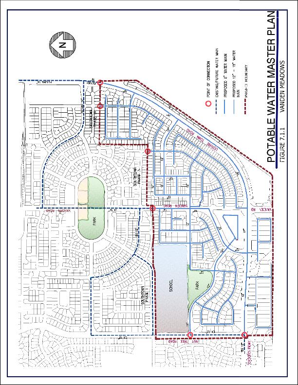
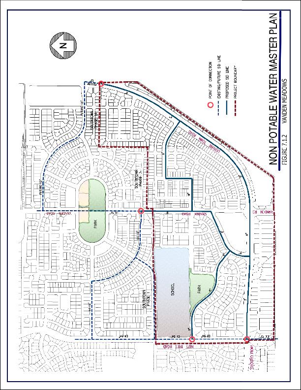
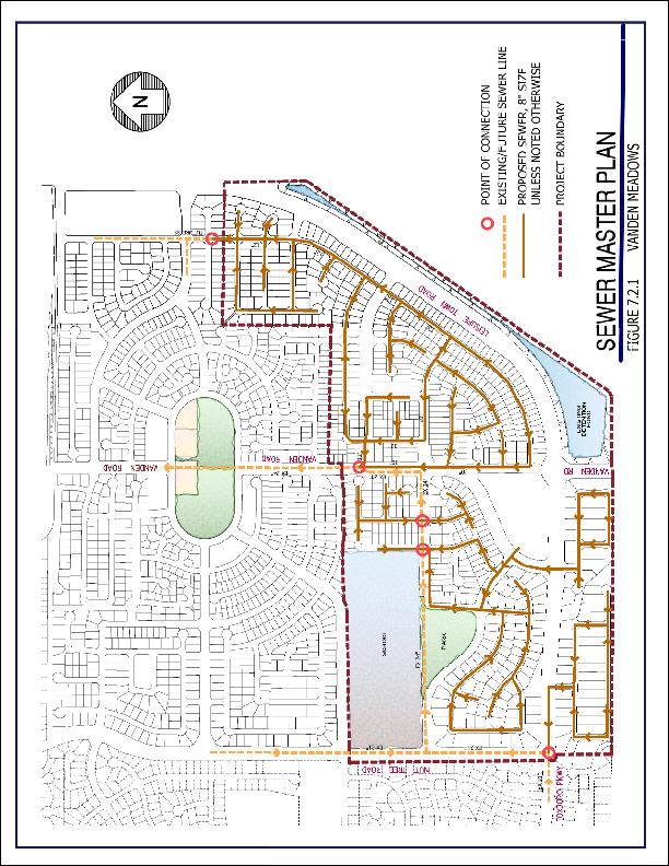
55 7.2 WATER SUPPLY Goal: Provide an adequate and reliable source of potable and non potable water for the Vanden Meadows Specific Plan area Potable Water Supply Figure shows the Water Master Plan with existing and proposed water line sizes. In general, Leisure Town Road will have an 18 water main with 12 water mains in all arterials and collectors. In addition, 12 water mains will be adjacent to and through higher density areas to ensure adequate fire flow. All other streets will contain an 8 water line with domestic services and fire hydrants as required to serve the development. 7.2 P 1 Each developer will be responsible for construction of their portion of the water lines shown on the Water Master Plan. Each developer will be required to demonstrate that the proposed phasing of water line installation will provide for adequate redundancy (looping) and flow to the satisfaction of the Director of Public Works. 7.2 P 2 Developers will comply with the City of Vacaville water conservation ordinance (such as low flow shower heads and toilets) in the construction of the homes. 7.2 P 3 Developers will use low flow irrigation systems and drought resistant plant materials to the reasonable extent feasible. DIF 88 The 18 water main in Leisure Town Road has been identified as a capitol improvement project (DIF 88) within the City of Vacaville Development Impact Fee Ordinance and is subject to partial reimbursement to the developer who installs any portion of this line as outlined within said ordinance Non Potable Water Supply Figure shows the Non Potable Water Master Plan with existing and proposed water line sizes. In general, 8 water mains are to be located in all arterials and within Vanden Road creating a non potable looped system
56 with the South Vanden non potable system. 6 8 lines are to be located internally as necessary to serve their respective developments.
57
58
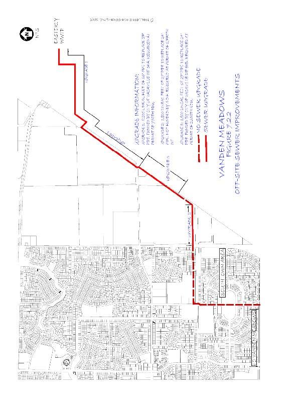
59 7.3 SEWER Goal: Provide an adequate and reliable wastewater collection system for the Vanden Meadows Specific Plan area. Figure shows the Sewer Master Plan with existing and proposed line sizes. In general, all streets will have a minimum of an 8 line. Within a small number of streets, 10 lines are shown. 7.2 P 1 Each developer will be responsible for construction of their portion of the sewer lines shown on the Sewer Master Plan. Each developer will be required to demonstrate that the proposed phasing of sewer line installation will provide for adequate collection and conveyance of wastewater to the satisfaction of the Director of Public Works. In addition to the on site sewer improvements which will be required to service the Vanden Meadows development, three off site sewer improvements were identified in the report prepared by West Yost Associates titled: Southtown Area Sewer Plan Evaluation and CSPS Trunk Sewer Service Area Master Plan. These improvements and the timing for when the improvements are required are described as follows (See Figure Off Site Sewer Improvements for details): Upgrade 1: Triggered by issuance of the 770 th building permit within the Southeast Vanden area (which includes both Southtown and Vanden Meadows). The upgrade requires the replacement of approximately 8,200 lineal feet of existing 27 SS with 36 SS. West Yost Associates (WYA) estimated the cost at $7.45 million. Depending on timing for buildout of Southtown and Vanden Meadows, these improvements could be triggered by Southtown before Vanden Meadows acquires any building permits. These improvements are included in DIF 54A and as such the developer that records a subdivision final map creating the 770 th unit and constructs these improvements will be eligible for fee credits related to this work.
60 Upgrade 2: This upgrade is triggered by issuance of the 1,700 th building permit within the Southeast Vanden area. The work involves replacing approximately 1,800 lineal feet of existing 24 SS with 27 SS. WYA estimated the cost at $1.44 million. This work will very likely to be triggered by permits for Vanden Meadows. Since these improvements are not listed in the City of Vacaville DIF program the developer that installs these improvements will receive a credit for their fees related to the Southeast Vanden Benefit District. Upgrade 3: This upgrade is triggered by issuance of 2,350 th building permit in the Southeast Vanden area. The work involves replacing approximately 1,200 lineal feet of existing 27 SS with 30 SS. WYA estimates the cost at $1.62 million. This work will very likely to be triggered by permits for Vanden Meadows. And like Upgrade 1, these improvements are included in DIF 54B and as such the developer that pulls the 2350 th permit and constructs these improvements will be eligible for fee credits related to this work.
61
62
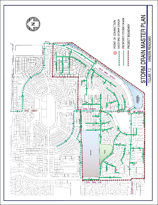
63 7.4 STORM DRAINAGE Goal: Provide an adequate, efficient and environmentally compatible storm drainage system for the Vanden Meadows Specific Plan area Existing Setting In 2005, WYA produced a report titled Southeast Vanden Area Major Drainage Facilities Master Plan as part of the Southtown Project. In that report they identified major facilities that were required with the Southtown Project and with ultimate development of the Southeast Vanden area. With the development of the Southtown Project, the Southtown Phase 1 and Phase 1A Required Improvements were installed to service the entire Southeast Vanden area. Included in these backbone improvements were the 17 Acre +/ detention basin, twin 72 and twin 60 pipes in Vanden Road and Opal Way to collect and convey the water from the Foxboro area as well as on site. Figure 7.3 Storm Drain Master Plan, details the existing and proposed improvements to complete the Storm Drainage improvements in the area. Developers in the Vanden Meadows area will be required to reimburse the Southtown developers for their fair share of storm drainage infrastructure improvements per the Southeast Vanden Benefit District Completion of Storm Drainage Improvements The WYA Report calls for the completion of the following improvements not constructed with the Southtown Project: 1. The existing SID twin 36 CMP culverts located just east of the Railroad shall be replaced with twin 60 culverts and a 36 culvert. 2. Under ultimate development of the Southeast Vanden Area an additional 190 cfs during the 10 year storm and about 310 cfs during the 100 year storm will be discharged into the existing open channel east of the Railroad (Noonan Drain and the D 1 C Spill); therefore the following improvements are required:
64 a. The existing culverts at Meridian Road, Hay Road, and the private farm road shall be replaced with one of the following alternatives: i. Twin 96 RCP culverts. The new culverts shall include concrete headwalls. ii. 16 by 8 ConSpan culverts shall be installed at Meridian Road and Hay Road, and 16 by 10 ConSpan culvert at the private farm road. b. The top of bank shall be raised along the following reaches (See Table 7 of the WYA Report for more detail): i. River Station to along the left bank; ii. River Station to along the right bank; iii. River Station to along the right bank: and from Station to along both banks; iv. River Station to along the right bank; v. River Station to along both banks; and Station to along the left bank. As an alternative to the above improvements, the Developer may commission an update to the Southeast Vanden Area Major Drainage Facilities Master Plan to ascertain if other options are available. 7.4 P 1 Complete storm drainage improvements per the Southeast Vanden Area Major Drainage Facilities Master Plan (as may be amended) and reimburse the Southtown developers for their fair share of storm drainage infrastructure installed with that project.
65
66 7.5 STORM WATER QUALITY Introduction The Vanden Meadows project is committed to fulfilling its Clean Water Runoff requirements. As required by the Regional Water Quality Control Board the project will have a Stormwater Pollution Prevention Plan (SWPPP) for the project along with identifying the Best Management Practices (BMPs) planned for implementing and maintaining procedures outlined in the SWPPP. 7.5 P 1 Prepare and implement a comprehensive Stormwater Pollution Prevention Plan (SWPPP) for the project. 7.5 P 2 The Project SWPPP shall identify all Best Management Practices (BMPs) planned for implementation during and following project construction, including Source Control BMPs, Treatment Control BMPs and Post Construction BMPs. The South Vanden Detention Basin constructed by the Southtown Project is intended to serve as a regional detention basin and as the South Vanden Post Construction Storm Water Quality BMP device. 7.5 P 3 Require drainage facilities to minimize any increased potential for erosion or flooding. 7.6 FLOODPLAINS Introduction The Vanden Meadows area is not within a floodplain, as depicted on FEMA s Flood Insurance Rate Map (FIRM) Community Panel Numbers 06095C0279E and 06095C0283E dated July 3, P 1 Ensure that the project continues to remain outside the floodplain in conformance with FEMA standards.
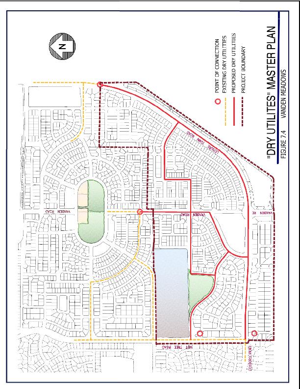
67 7.7 NATURAL GAS, ELECTRICITY, TELEPHONE, AND CABLE TELEVISION SERVICE Goal: To provide a full complement of community services as needed in the Vanden Meadows area Introduction Gas and electric will be provided by Pacific Gas & Electric (PG&E). Telephone will be provided by SBC, and cable television will be provided by Comcast. All new utilities within the Specific Plan area will be under grounded. The existing overhead lines within the Specific Plan will be placed underground to the limits of the proposed project. 7.7 P 1 During the improvement plan design process the City of Vacaville and the developer will work with the utility companies to locate their transmission line corridors within the rights of way for streets. 7.7 P 2 During the improvement plan design process, the City of Vacaville and the developer will work with the utility companies to ensure that all new utilities and utility vault appurtenances will be placed underground in accordance with the Vacaville Municipal Code.
68
VANDEN MEADOWS SPECIFIC PLAN TABLE OF CONTENTS Page 1.0 INTRODUCTION SUMMARY Schools Foxboro Parkway
 VANDEN MEADOWS SPECIFIC PLAN TABLE OF CONTENTS Page 1.0 INTRODUCTION 6 1.1. SUMMARY 6 1.1.1. Schools 11 1.1.2. Foxboro Parkway 11 1.1.3. Improvements to Leisure Town Road 11 1.1.4. New Neighborhood Park
VANDEN MEADOWS SPECIFIC PLAN TABLE OF CONTENTS Page 1.0 INTRODUCTION SUMMARY Schools Foxboro Parkway
 0 VANDEN MEADOWS SPECIFIC PLAN TABLE OF CONTENTS Page 1.0 INTRODUCTION 6 1.1. SUMMARY 6 1.1.1. Schools 11 1.1.2. Foxboro Parkway 11 1.1.3. Improvements to Leisure Town Road 11 1.1.4. New Neighborhood Park
ARTICLE 6: Special and Planned Development Districts
 ARTICLE 6: Special and Planned Development Districts 6-10 Traditional Neighborhood Development (TND) District 6-10.10 Purpose and Intent The Traditional Neighborhood Development (TND) District provides
DISCUSSION ON VACAVILLE S2 INVESTORS PROPERTY IN URBAN RESERVE
 Agenda Item No. 9C April 25, 2017 TO: FROM: SUBJECT: Honorable Mayor and City Council Attention: Jeremy Craig, Interim City Manager Barton Brierley, AICP, Community Development Director (Staff Contact:
SPECIFIC PLAN Requirements
 CITY OF LANCASTER PLANNING DEPARTMENT 44933 Fern Avenue, Lancaster, California 93534 (661) 723-6100 SPECIFIC PLAN Requirements Purpose The purpose of a specific plan is to provide for the logical development
CITY OF VACAVILLE PLANNING COMMISSION Agenda Item No. G.1 STAFF REPORT February 21, 2012 BRIGHTON LANDING SPECIFIC PLAN & DEVELOPMENT PROJECT
 CITY OF VACAVILLE PLANNING COMMISSION Agenda Item No. G.1 STAFF REPORT February 21, 2012 Staff Contact: Fred Buderi (707) 449-5307 TITLE: PURPOSE: BRIGHTON LANDING SPECIFIC PLAN & DEVELOPMENT PROJECT INFORMATIONAL
Planning Commission Staff Report June 5, 2008
 Owner/Applicant Taylor Village Sacramento Investments Partners, LP c/o Kim Whitney 1792 Tribute Road #270 Sacramento, CA 95815 Staff Recommendation Planning Commission Staff Report Project: File: Request:
Gold Line Bus Rapid Transit Transit Oriented Development (BRTOD) Helmo Station Area Plan
 Helmo Station Area Plan") Appendix F Gold Line Bus Rapid Transit Transit Oriented Development (BRTOD) Helmo Station Area Plan Introduction and Purpose of the Plan The Gold Line Bus Rapid Transit facility is an eleven-mile dedicated
Appendix F Gold Line Bus Rapid Transit Transit Oriented Development (BRTOD) Helmo Station Area Plan Introduction and Purpose of the Plan The Gold Line Bus Rapid Transit facility is an eleven-mile dedicated
3. VISION AND GOALS. Vision Statement. Goals, Objectives and Policies
 Vision Statement Queen Creek s interconnected network of parks, trails, open spaces and recreation opportunities provide safe and diverse activities and programs that sustain its unique, small town, equestrian
Ten Mile Creek Planning Area
 PLANNING AREA POLICIES TEN MILE CREEK Ten Mile Creek Planning Area Location and Context The Ten Mile Creek Planning Area ( Ten Mile Creek area ) is located south of the current Boise AOCI, generally south
The transportation system in a community is an
 7 TRANSPORTATION The transportation system in a community is an important factor contributing to the quality of life of the residents. Without a sound transportation system to bring both goods and patrons
Joint Study Session of the Sutter County. March 2, 2009
 Joint Study Session of the Sutter County Board of Supervisors and Planning Commission March 2, 2009 CURRENT APPLICATION General Plan Amendment Specific Plan Specific Plan Appendices Utility Plans Transit/AQ
Baumgarten MPUD. Exhibit 3 Evaluation Criteria
 Pursuant to LDC subsections 10.02.13 B, 10.02.08 F and Chapter 3 G. of the Administrative Code, staff s analysis and recommendation to the Planning Commission, and the Planning Commission s recommendation
EXHIBIT B PROJECT NARRATIVE POULSBO MEADOWS
 EXHIBIT B PROJECT NARRATIVE POULSBO MEADOWS Name of Project: Poulsbo Meadows; A Planned Residential Development (PRD)/Plat Applicants Name: PBH Group LLC/Byron Harris PO Box 1010 Silverdale, WA 98038 Description
Planning Districts INTRODUCTION
 INTRODUCTION To facilitate detailed examination of development prospects for all areas of the community, Delano has been divided into 14 planning districts. The location of these planning districts is
PLANNING COMMISSION. Submitted
 PLANNING COMMISSION City Hall 1275 Main Street El Centro, CA 92243 Submitted PLANNING COMMISSION ACTION ITEM (1844) Meeting: 05/10/16 12:00 AM Department: Community Development Category: Public Hearing
Glenborough at Easton Land Use Master Plan
 Implementation 114 9.0 IMPLEMENTATION 9.1 OVERVIEW This chapter summarizes the administrative procedures necessary to implement the proposed land use plan, infrastructure improvements, development standards,
Asbury Chapel Subdivision Sketch Plan
 Asbury Chapel Subdivision Sketch Plan PART 1: PROJECT SUMMARY Applicant: NVR Inc. Project Size: +/- 76.13 acres Parcel Numbers: 02101112,02116101,02116112, 02116113 Current Zoning: Transitional Residential
PORT WHITBY COMMUNITY
 PORT WHITBY COMMUNITY SECONDARY PLAN UPDATE COMMUNITY IMPROVEMENT PLAN URBAN DESIGN GUIDELINES September 2015 DRAFT PROPOSED AMENDMENT NUMBER # to the Whitby Official Plan PURPOSE: The intent of this Amendment
Town of Portola Valley General Plan. Nathhorst Triangle Area Plan
 Town of Portola Valley General Plan Amended December 10, 1997 Table of Contents Introduction... 1 Planning Area... 1 Objectives... 2 Principles... 2 Standards... 4 Description... 4 Community Commercial...
Major Subdivision Sketch Plan Checklist
 This checklist provides specific requirements that are apart of the Sketch process. The entire process is described by the Huntersville Subdivision Review Process which details all the submittal and resubmittal
Applicant Name Phone / Fax / Address City State Zip Code . Property Owner Phone / Fax / Address City State Zip Code
 Master Development Plan Application Community Development Department City of Redmond 411 SW 9 th Street Redmond, Oregon 97756 541-923-7721 541-548-0706 FAX Master Development Plan Fee $38,862.52 File Number
Review of Opportunity Area C Draft Comprehensive Plan and Draft BOS Follow-On Motions. Special Working Group Meeting March 4, 2015
 Review of Opportunity Area C Draft Comprehensive Plan and Draft BOS Follow-On Motions Special Working Group Meeting March 4, 2015 The slides that follow identify where the draft Comprehensive Plan has
2.0 AREA PLANS. Lakeside Business District. Lakeside Business District Land Use Categories:
 Lakeside Business District Lakeside Business District Land Use Categories: Campus Commercial Campus Commercial means a mixture of uses which includes corporate offices, office parks, hotels, commercial,
KEIZER STATION PLAN INTRODUCTION
 KEIZER STATION PLAN INTRODUCTION Planning for this area began in 1987 when the Keizer Comprehensive Plan established the Chemawa Activity Center and McNary Activity Center. The first Chemawa Activity Center
LAND USE AMENDMENT CORNERSTONE (WARD 3) 60 STREET NE AND COUNTRY HILLS BOULEVARD NE MAP 26NE BYLAW 22D2017
 60 STREET NE AND COUNTRY HILLS BOULEVARD NE MAP 26NE BYLAW 22D2017") Page 1 of 14 EXECUTIVE SUMMARY This Land Use Amendment application covers an area of 43.76 hectares ± (108.14 acres ±) located in northeast Calgary, bound by Country Hills Boulevard NE to the south and
Page 1 of 14 EXECUTIVE SUMMARY This Land Use Amendment application covers an area of 43.76 hectares ± (108.14 acres ±) located in northeast Calgary, bound by Country Hills Boulevard NE to the south and
KASPER. City of Georgetown, Texas PUD Planned Unit Development. December 30, 2015 Revised January 27, 2016
 KASPER City of Georgetown, Texas PUD Planned Unit Development December 30, 2015 Revised January 27, 2016 Applicant: Sentinel Land Company, LLC 4910 Campus Drive Newport Beach, CA Prepared by: SEC Planning
Dwelling Units Max 12 dwelling units per acre/min 8 dwelling units per acre. Development Mix 80% non residential/20% residential
 13. OSTEEN LOCAL PLAN Background: The Osteen Local Plan area is located in southwest Volusia County along the SR 415 corridor between Lemon Bluff Road and Acorn Lake Road and includes 3,990 acres. The
ELMVALE ACRES SHOPPING CENTRE MASTER PLAN
 ELMVALE ACRES SHOPPING CENTRE MASTER PLAN Contents 1.0 INTRODUCTION... 2 2.0 LOCATION... 2 3.0 EXISTING CONTEXT... 2 4.0 VISION & GUIDING PRINCIPLES... 2 5.0 LAND USE AND BUILT FORM... 4 5.1 St. Laurent
Chapter Master Planned Communities (MPC) District
 District") Sections 14.53.010 Purpose and Intent 14.53.020 Applicability 14.53.030 Procedure 14.53.040 MPC Standards 14.53.050 Required Findings 14.53.010 Purpose and Intent Chapter 14.53 Master Planned Communities
Sections 14.53.010 Purpose and Intent 14.53.020 Applicability 14.53.030 Procedure 14.53.040 MPC Standards 14.53.050 Required Findings 14.53.010 Purpose and Intent Chapter 14.53 Master Planned Communities
Section 9 NEIGHBORHOOD DESIGN
 Section 9 NEIGHBORHOOD DESIGN City of Lancaster Comprehensive Plan D u n k i n, S e f k o & A s s o c i a t e s, I n c. NEIGHBORHOOD DESIGN INTRODUCTION There are many ways in which a neighborhood can
5.1 Site Plan Guidelines
 5. Community Core Guidelines Development of the Community Core will take place by plan of subdivision and site plan approval. It will occur in a phased manner that will reflect the timing of residential
URBAN DESIGN BRIEF URBAN DESIGN BRIEF 721 FRANKLIN BLVD, CAMBRIDGE August 2018
 URBAN DESIGN BRIEF URBAN DESIGN BRIEF 721 FRANKLIN BLVD, CAMBRIDGE August 2018 DESIGN BRIEF CONTENTS PART A 1.0 INTRODUCTION 2.0 DESCRIPTION & ANALYSIS OF SITE CONTEXT 3.0 DESIGN CONSTRAINTS AND OPPORTUNITIES
COMMUNITY DESIGN. GOAL: Create livable and attractive communities. Intent
 COMMUNITY DESIGN Intent An attractive, well-designed County will attract quality development, instill civic pride, improve the visual character of the community, and create a strong, positive image for
Amendment to the Elderberry Neighborhood Development Plan
 Amendment to the Elderberry Neighborhood Development Plan Recommendations for Land Use, Transportation and Development July 13, 2018 City of Madison, Wisconsin Department of Planning and Community and
EXHIBIT A. Tax Increment Reinvestment Zone No. 1 (Town Center) First Amended Project Plan 1
 First Amended Project Plan 1") EXHIBIT A Tax Increment Reinvestment Zone No. 1 (Town Center) First Amended Project Plan 1 1 As amended by Resolution No. 2008-02-001(TR1R) of the Tax Increment Reinvestment Zone No.1, and approved to
EXHIBIT A Tax Increment Reinvestment Zone No. 1 (Town Center) First Amended Project Plan 1 1 As amended by Resolution No. 2008-02-001(TR1R) of the Tax Increment Reinvestment Zone No.1, and approved to
Parks, Trails, and Open space Element
 Parks, Trails, and Open space Element Parks, Trails, and Open Space element Parks, Recreation, and Open Space are important components of the quality of life desired by the residents of Elk Grove. This
Mitchell Ranch South MPUD Application for Master Planned Unit Development Approval Project Narrative. Introduction
 Mitchell Ranch South MPUD Application for Master Planned Unit Development Approval Project Narrative Introduction Mitchell Ranch South is a proposed single family (detached) residential development on
OP Council Resolution June 16, Planning and Development Services
 OP-08-01 Council Resolution June 16, 2008 Planning and Development Services Kingsgate Landing Outline Plan Table of Contents 1.0 Introduction 1 1.1 Purpose of Plan 1 1.2 Plan Area Location 1 1.3 Ownership
REQUEST Current Zoning: O-15(CD) (office) Proposed Zoning: TOD-M(CD) (transit oriented development mixed-use, conditional)
 (office) Proposed Zoning: TOD-M(CD) (transit oriented development mixed-use, conditional)") Rezoning Petition 2016-117 Zoning Committee Recommendation January 4, 2017 REQUEST Current Zoning: O-15(CD) (office) Proposed Zoning: TOD-M(CD) (transit oriented development mixed-use, conditional) LOCATION
Rezoning Petition 2016-117 Zoning Committee Recommendation January 4, 2017 REQUEST Current Zoning: O-15(CD) (office) Proposed Zoning: TOD-M(CD) (transit oriented development mixed-use, conditional) LOCATION
APPENDIX C SPECIAL PLANNING AREAS
 SPECIAL PLANNING AREAS There are five Special Planning Areas (SPAs) on the Land Use Diagram (Figure LU-2). The SPAs are areas with significant new growth potential that require more detailed subsequent
COLVER ROAD INDUSTRIAL CONCEPT PLAN
 COLVER ROAD INDUSTRIAL CONCEPT PLAN A CONCEPTUAL LAND USE AND TRANSPORTATION PLAN FOR TA-4 AN URBAN RESERVE AREA OF THE CITY TALENT City of Talent Adopted by City Council Resolution No., June, 2015 PART
City of Grande Prairie Development Services Department KENNEDY DEVELOPMENTS LTD. OUTLINE PLAN OP-09-01
 City of Grande Prairie Development Services Department KENNEDY DEVELOPMENTS LTD. OUTLINE PLAN OP-09-01 July 27, 2009 TABLE OF CONTENTS 1.0 Introduction... 1 1.1 Plan Area Location & Context... 1 1.2 Ownership
SAN RAFAEL GENERAL PLAN 2040 INTRODUCTION AND OVERVIEW
 SAN RAFAEL GENERAL PLAN 2040 INTRODUCTION AND OVERVIEW Steering Committee Presentation February 14, 2018 Purpose of General Plan Guide land use and development decisions Coordinate transportation, infrastructure,
WASHINGTON COUNTY OREGON
 WASHINGTON COUNTY OREGON July 9, 2009 Revisions to Chapter 2 of the Bethany Community Plan The North Bethany Subarea Plan Exhibit pages 7 and 8 The sections for the Core and Flexible Streets were amended
Drexel, Barrell & Co.
 Drexel, Barrell & Co. June 18, 2018 Engineers/Surveyors Boulder Colorado Springs Greeley 3 South 7 th Street Colorado Springs, Colorado 80905-1501 719 260-0887 719 260-8352 Fax El Paso County Planning
9 th Street Sub Area Plan
 9 th Street Sub Area Plan In the 1990 s, when the Township prepared the last Master Plan, the 9 th Street corridor was studied as part of a larger 9 th Street Focus Area that included the West Main Street
Complete Neighbourhood Guidelines Review Tool
 Complete Neighbourhood Guidelines Review Tool Prepared By: City of Regina Planning Department October 2014 Page 1 of 14 Community Development Review Checklist for Secondary Plans and Concept Plans The
Vision Statement for the Town of Flower Mound Master Plan The Town of Flower Mound Master Plan furthers the established community based vision to:
 Vision Statement for the The furthers the established community based vision to: Preserve the country atmosphere and natural environment that makes Flower Mound a unique and desirable community; Mitigate
SDOT DPD. SDOT Director s Rule DPD Director s Rule DCLU DR SED DR of 7 CITY OF SEATTLE
 SDOT SDOT Director s Rule 2-07 DPD Applicant: CITY OF SEATTLE Page 1 of 7 Supersedes: DCLU DR 11-93 SED DR 93-4 Seattle Department of Transportation (SDOT) Department of Planning and Development (DPD)
POCKET COMMUNITY PLAN
 POCKET COMMUNITY PLAN Part Three : COMMUNITY PLAN AREAS AND SPECIAL STUDY AREAS CONTENTS Community Location... 3-P-3 Community Vision... 3-P-4 Community Profile... 3-P-4 Community Issues... 3-P-6 Land
4.1.3 LAND USE CATEGORIES
 4.1.3 LAND USE CATEGORIES a. City Center District The City Center District incorporates the existing character and mix of uses in downtown Belmont to encourage redevelopment and new development in keeping
BROOKHILL NEIGHBORHOOD MODEL ZONING MAP AMENDMENT PREFACE TO APPLICATION
 BROOKHILL NEIGHBORHOOD MODEL ZONING MAP AMENDMENT PREFACE TO APPLICATION June 15, 2015 Revised: August 1, 2016 I. VISION Brookhill is a proposed community based upon the principles of Albemarle County
Drexel, Barrell & Co.
 Drexel, Barrell & Co. December 21, 2018 Engineers/Surveyors Boulder Colorado Springs Greeley 3 South 7 th Street Colorado Springs, Colorado 80905-1501 719 260-0887 719 260-8352 Fax El Paso County Planning
URBAN DESIGN BRIEF. 2136&2148 Trafalgar Road. Town of Oakville
 URBAN DESIGN BRIEF 2136&2148 Trafalgar Road Town of Oakville Prepared By: METROPOLITAN CONSULTING INC For 2500674 Ontario Inc November 2016 TABLE OF CONTENTS Page No. 1.0 Introduction/Description of Subject
Outline Plan in Belvedere (Ward 9) at Street SE, LOC (OP)
 at Street SE, LOC (OP)") 2018 October 04 Page 1 of 12 EXECUTIVE SUMMARY This outline plan application was submitted by B&A Planning Group on 2016 July 15, on behalf of Tristar Communities Inc. for 50.14 hectares (123.89 acres)
2018 October 04 Page 1 of 12 EXECUTIVE SUMMARY This outline plan application was submitted by B&A Planning Group on 2016 July 15, on behalf of Tristar Communities Inc. for 50.14 hectares (123.89 acres)
Venice Pumping Plant Dual Force Main Project Draft EIR
 City of Los Angeles 5.9 LAND USE PLANS 5.9.1 Environmental Setting Venice Pumping Plant Dual Force Main Project Draft EIR The Project lies within the bounds of Los Angeles County and the City of Los Angeles.
SECTION UNIFIED DEVELOPMENT ORDINANCE SECTION Part 1 Ordinance. ARTICLE 1 Zoning Districts
 SECTION 1-100 UNIFIED DEVELOPMENT ORDINANCE SECTION 1-300 Part 1 Ordinance SECTION 1-100. Introduction. ARTICLE 1 Zoning Districts Crystal Lake strives to maintain a balance of various land uses for a
Transportation. Strategies for Action
 Transportation A major priority for the Overlake Neighborhood is to develop a multimodal transportation system. To achieve this system, a balance has to be found among travel, circulation and access needs;
EXISTING COMPREHENSIVE PLAN
 EXISTING COMPREHENSIVE PLAN Town Center Land Use Element: V. LAND USE POLICIES Town Center Mercer Island's business district vision as described in "Your Mercer Island Citizen-Designed Downtown" was an
RECREATION AND OPEN SPACE ELEMENT GOALS, OBJECTIVES, AND POLICIES
 RECREATION AND OPEN SPACE ELEMENT GOALS, OBJECTIVES, AND POLICIES Goal 7 To provide park facilities, recreation programs, and open space resources that are safe, adequate, and accessible to all City residents,
PLANNED UNIT DEVELOPMENT & SUBDIVISION STAFF REPORT Date: May 18, 2017
 & PUD-0000102-2017 PLANNED UNIT DEVELOPMENT & SUBDIVISION STAFF REPORT Date: May 18, 2017 NAME SUBDIVISION NAME Dauphin Creek Estates Subdivision Dauphin Creek Estates Subdivision LOCATION CITY COUNCIL
CONTENTS 8.0 LAND USE 8.1 GENERAL LAND USE 8.2 RESIDENTIAL 8.3 MIXED USE 8.4 COMMERCIAL 8.5 EMPLOYMENT LANDS
 8-2 Land Use 8.0 LAND USE CONTENTS 8.1 GENERAL LAND USE 8.1.1 Uses provided for in all Land Use Designations 8.1.2 Uses prohibited in Hazardous Lands, Hazardous Sites and Special Policy Areas 8.1.3 Uses
BUILDER LOTS FOR SALE
 BUILDER LOTS FOR SALE NORTHERN CULPEPER - 135 ACRES RESIDENTIAL DEVELOPMENT 1256 Old Bridge Road, Amissville, VA 20106 SALE PRICE: $995,000 LOT SIZE: 135+ Acres APN #: Tax Map 2 Parcel 23 ZONING: R-1 ACCESS:
Description of Preferred Alternative
 Chapter 2 Description of Preferred Alternative 2.1 Introduction This chapter of the programmatic Sammamish Town Center Sub-area Plan Final EIS provides a more detailed description of the Preferred Alternative
Staff Report and Recommendation
 Community Planning and Development Planning Services 201 W. Colfax Ave., Dept. 205 Denver, CO 80202 p: 720.865.2915 f: 720.865.3052 www.denvergov.org/cpd TO: City Council Neighborhoods and Planning Committee
TO: CITY COUNCIL DATE: MARCH 23,2009
 Report TO: CITY COUNCIL DATE: MARCH 23,2009 FROM: CITY MANAGER SUBJECT: MASTER DEVELOPMENT PLAN AMENDMENT FOR PASADENA CHRISTIAN SCHOOL AT 1515 NORTH LOS ROBLES AVENUE AND GENERAL PLAN AMENDMENT AND ZONE
AWH REPORT OF THE PLANNING AND DEVELOPMENT DEPARTMENT FOR APPLICATION FOR REZONING ORDINANCE TO PLANNED UNIT DEVELOPMENT
 AWH REPORT OF THE PLANNING AND DEVELOPMENT DEPARTMENT FOR APPLICATION FOR REZONING ORDINANCE TO PLANNED UNIT DEVELOPMENT MAY 8, 2014 The Planning and Development Department hereby forwards to the Planning
I. Introduction. Prior Approvals
 Statement of Justification First National Bank 19790 Crystal Rock Drive, Germantown, Maryland Application for Site Plan and Limited Preliminary Plan Amendment I. Introduction DPH Architecture, for First
Seneca Meadows. Block 4 Locate office, technology, and medical development adjacent to I Screen views of garage structures from I-270.
 Seneca Meadows Seneca Meadows has an industrial park in its southern end and a mixed-use employment area planned for the north end. The district benefits from extensive I-270 visibility, stream valley
A. WHAT IS A GENERAL PLAN?
 I. Introduction A. WHAT IS A GENERAL PLAN? A general plan is the planning guideline for the future of a city. It contains goals and policies which regulate urban development, the protection of the natural
ADMINISTRATION RECOMMENDATION 2016 November 03. That Calgary Planning Commission recommends APPROVAL of the proposed Land Use Amendment.
 Page 1 of 12 EXECUTIVE SUMMARY This Land Use Amendment application covers an area of 75.76 hectares ± (187.20 acres ±) located in northeast Calgary, bound by Stoney Trail NE to the north, 128 Avenue NE
MIDTOWN MIXED-USE VILLAGE. TECHNICAL DATA SHEET COMPONENT C-1 FOR PUBLIC HEARING - PETITION NUMBER Project No RZ1.1. Issued.
 N MIDTOWN MIXED-USE VILLAGE TECHNICAL DATA SHEET COMPONENT C- FOR PUBLIC HEARING - PETITION NUMBER 04-00 Project No. 496 Issued Revised SCALE: " = 0' N 0 0 0 40 RZ. c GENERAL PROVISIONS: a. SITE LOCATION.
3.10 LAND USE SETTING PROJECT SITE EXISTING LAND USE DESIGNATIONS AND ZONING. General Plan Land Use Designations.
 This section of the Draft EIR addresses the existing land uses on and adjacent to the project site and discusses the potential impacts of the proposed project on existing land uses. Key issues addressed
2. Form and Character. 2.1 Introduction. 2.2 The Downtown Addition Plan. 2.1 Introduction
 2.1 Introduction 2.1 Introduction This section of the Specific Plan describes and illustrates the desired form, character and uses of the Downtown Addition and explains the underlying design principles.
Northwest Rail Corridor and US 36 BRT Development Oriented Transit Analysis 4.4 STATION AREA FINDINGS
 4.4 STATION AREA FINDINGS Each station is different, and each one requires a separate set of recommendations based on the vision for the site. This section outlines an initial TOD strategy and recommendations
4.1 LAND USE AND PLANNING EXISTING CONDITIONS REGULATORY BACKGROUND LAND USES IN THE PLAN AREA SURROUNDING LAND USES
 4.1 LAND USE AND PLANNING This section includes a description of the existing land use plans that apply to the Plan area and a description of existing land uses in the vicinity. It also includes an analysis
The Ritz-Carlton, Paradise Valley
 The Ritz-Carlton, Paradise Valley 7000 E. Lincoln Drive Keys to Success Community Conversation II June 4, 2015 RITZ-CARLTON PARADISE VALLEY Town Council Study Session June 4, 2015 General Plan 2012 Land
CHAPTER 7: VISION AND ACTION STATEMENTS. Noble 2025 Vision Statement
 CHAPTER 7: VISION AND ACTION STATEMENTS This chapter presents the vision, policy and action statements that transform the comprehensive planning study, an analysis of Noble s past, future trends and community
Proposed Comprehensive Plan Strategies DRAFT for discussion June 28, 2017
 Proposed Comprehensive Plan Strategies DRAFT for discussion June 28, 2017 Land Use Rural Areas Refine the Farm and Forest area (FF) Update FF boundaries to account for existing lots less than five acres
Planned Development Review Revisions (Project No. PLNPCM )
") Planned Development Review Revisions (Project No. PLNPCM2014-00139) Standard residential development Planned Development Example: Smaller lot sizes than what is allowed to create open space amenity. What
Planned Development Review Revisions (Project No. PLNPCM2014-00139) Standard residential development Planned Development Example: Smaller lot sizes than what is allowed to create open space amenity. What
Secrest Short Cut and Monroe Expressway Small Area Plan AUGUST 29, 2018
 Secrest Short Cut and Monroe Expressway Small Area Plan AUGUST 29, 2018 Background and Process Monroe Expressway will be open by the end of 2018 Union County and Indian Trail identified a need to revisit
Red Fox Commercial Outline Plan
 Red Fox Commercial Outline Plan City of Cold Lake, Alberta Prepared by Durrance Projects Ltd and Ross W. Sharp & Associates Ltd October 2014 Rupert 1 Table of Contents 1. PURPOSE...3 1.1. Location...4
SECTION 6 - LAND USE - RURAL RESIDENTIAL
 16.6.10.1 Intent The intent of the rural residential land use category is to provide low-density, single-family residential development within the Town s outer fringe. The current land is predominantly
Appendix I-A3 DENAIR COMMUNITY PLAN
 Appendix I-A3 DENAIR COMMUNITY PLAN Adopted by the Stanislaus County Board of Supervisors DECEMBER 15, 1998* *A technical update removing reference to the former Stanislaus County Redevelopment Agency
PLANNED UNIT DEVELOPMENT Date: April 5, 2018
 PLANNED UNIT DEVELOPMENT Date: April 5, 2018 DEVELOPMENT NAME SUBDIVISION NAME LOCATION Robert Myers Robert Myers 2955 and 2989 Dauphin Street (Southeast corner of Dauphin Street and Sage Avenue) CITY
Civic Center District
 Civic Center District The Civic Center district is the civic and social heart of Warrenville, containing such public buildings as the City Hall, Warrenville Public Library, Police Station, Park District
I615. Westgate Precinct
 I615. Westgate Precinct I615.1. Precinct Description The Westgate Precinct is located approximately 18km west of the Auckland city centre. There are seven Sub-precincts in the Westgate Precinct: Sub-precinct
Parks, Trails, and Open Space Element
 P arks, Recreation, and Open Space are important components of the quality of life desired by the residents of Elk Grove. This Element of the General Plan addresses the City s goals, policies, and actions
CHAPTER 7: Transportation, Mobility and Circulation
 AGLE AREA COMMUNITY Plan CHAPTER 7 CHAPTER 7: Transportation, Mobility and Circulation Transportation, Mobility and Circulation The purpose of the Transportation, Mobility and Circulation Chapter is to
SOUTH NATOMAS COMMUNITY PLAN
 SOUTH NATOMAS Community Plan Part Three : COMMUNITY PLAN AREAS AND SPECIAL STUDY AREAS SACRAMENTO 2030 GENERAL PLAN Contents Community Location... 3-SN-3 Community Vision... 3-SN-4 Community Profile...
RESIDENTIAL PLANNED UNIT DEVELOPMENT / SUBDIVISION AND REZONING CONCEPT AND DEVELOPMENT STAGE PLAN SUBMITTAL NARRATIVE
 RESIDENTIAL PLANNED UNIT DEVELOPMENT / SUBDIVISION AND REZONING CONCEPT AND DEVELOPMENT STAGE PLAN SUBMITTAL NARRATIVE DEVELOPMENT TEAM DONEGAL SOUTH Maple Grove, Minnesota March 27, 2017 Applicant/Developer/Builder:
4. INDUSTRIAL 53 CASTLE ROCK DESIGN
 4. INDUSTRIAL 53 CASTLE ROCK DESIGN CASTLE ROCK DESIGN 54 4. INDUSTRIAL Overview Well-designed and attractive industrial centers are the product of blending economic realities with both functional and
SYRINGA VALLEY SPECIFIC PLAN NARRATIVE
 SYRINGA VALLEY SPECIFIC PLAN NARRATIVE Introduction With this application, Pleasant Valley South LLC ( Pleasant Valley ) seeks the City of Boise s approval of a new Specific Plan Ordinance to be added
MIXED-USE VILLAGE OVERLAY FLOATING DISTRICT
 MIXED-USE VILLAGE OVERLAY FLOATING DISTRICT Zoning regulations developed by committee to the Planning Board for the Town of DeWitt, NY Issue date: 13 July 2017 revised 3/12/2018, revised 4/26/2018, 5/9/2018
Land Use element LAND USE POLICY AREAS ESTATE AND RURAL RESIDENTIAL AREAS/RURAL SHELDON AREA OLD TOWN ELK GROVE
 Land Use element Land Use is often considered the heart of the General Plan. The statement of future land uses describes how the City believes it should develop in the future where housing, shopping, open
RESIDENTIAL DISTRICTS
 RESIDENTIAL DISTRICTS The residential district standards have been revised to reflect on-the-ground conditions, while continuing to respect the use patterns established within the neighborhoods. This will
Southeast Policy Area Community Plan
 City of Southeast Policy Area Community Plan Planning Department July 9, 2014 In November 2003, the City Council adopted the General Plan for the City of. The General Plan is the City s overarching policy
LAND USE AMENDMENT CORNERSTONE (WARD 3) COUNTRY HILLS BOULEVARD AND STONEY TRAIL NE BYLAW 9D2017
 COUNTRY HILLS BOULEVARD AND STONEY TRAIL NE BYLAW 9D2017") Page 1 of 12 EXECUTIVE SUMMARY This Land Use Amendment application covers an area of 54.92 hectares ± (135.71 acres ±) located in northeast Calgary, bound by Country Hills Boulevard NE to the north and
Page 1 of 12 EXECUTIVE SUMMARY This Land Use Amendment application covers an area of 54.92 hectares ± (135.71 acres ±) located in northeast Calgary, bound by Country Hills Boulevard NE to the north and
PART 1: PROJECT SUMMARY. Proposed Land Use: 120 single-family lots. The application is Attachment A. The site plan is Attachment B.
 PART 1: PROJECT SUMMARY Applicant: JBH Development, LLC and Hopper Communities, INC Project Size: +/- 80.48 acres Parcel Number: 01513107, 01513108, 01513109, 01513113, 01513120, 01513121, 01513122, 01513124,