Appendix I-A8 SALIDA COMMUNITY PLAN
|
|
|
- Scott Greer
- 5 years ago
- Views:
Transcription
1 Appendix I-A8 SALIDA COMMUNITY PLAN Adopted by the Stanislaus County Board of Supervisors AUGUST 7, 2007 *A technical update clarifying the integration of the 2007 Salida Area Planning, Road Improvement, Economic Development, and Farmland Protection Initiative and the terms of the development agreements governing the amended area was adopted on August 23, 2016, as part of the 2015 General Plan Update. I-137
2 THIS PAGE INTENTIONALLY LEFT BLANK
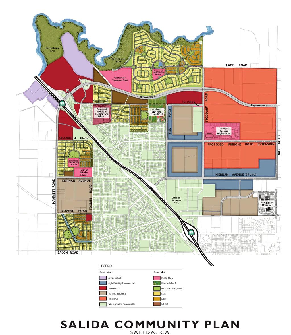
3 SALIDA LADD ROAD PROPOSED NEW ROADWAY STODDARD ROAD 99 SISK ROAD PROPOSED PIRRONE ROAD EXTENSION DALE ROAD KIERNAN AVENUE (SR 219) HAMMETT ROAD COVERT ROAD TOOMES ROAD HC 99 BACON ROAD LAND USES PARKS AND SCHOOLS PUBLIC FACILITIES Low Density Residential Existing Proposed New Road Low Density Residential (Within Project Boundary) Neighborhood Park* Special Treatment Area Medium Density Residential Elementary School* Amendment Area Boundary Medium High Density Residential Middle School* Existing Waste Water Treatment Plant* Business Park High School* Proposed Fire Station* Commercial Stanislaus River Park* Industrial Planned Industrial Planned Development COMMUNITY PLAN HC Highway Commercial Agricultural I-138 * Symbol denotes general location
4 THIS PAGE INTENTIONALLY LEFT BLANK
5 SALIDA COMMUNITY PLAN The Salida Community Plan (ACommunity or provides land use planning and guidance for development of approximately 4,600 acres of land in the Salida area. The Community Plan encompasses the existing community of Salida, which was part of the previously approved Salida Community Plan (the AExisting or AExisting Plan and an amendment area encompassing approximately 3,383 acres (the AAmendment The Amended Area consists of the Salida Area Planning, Road Improvement, Economic Development, and Farmland Protection Initiative (the Initiative ) approved by the Board of Supervisors on August 7, 2007, and adopted by ordinance on August 17, The ordinance specifies that until the terms of the Development Agreement governing the Amended Area expire, the Initiative may be amended or repealed, to the extent permitted by law, by a majority of the voters of the County voting in an election held in accordance with state law. The terms of the Development Agreement expires twenty-five (25) years from the effective date of August 7, 2007 (Expires: August 7, 2032). The Existing Plan Area The land use plan for the Existing Plan Area reflects both existing land use patterns and gathered information to guide future land use decisions. In formulating this plan, it was apparent that a substantial portion of the community had already developed in a way which has produced few areas of potential land use conflicts. The designations included within this plan are intended to, whenever possible, mitigate those impacts, or prevent them from occurring in the future. This will, hopefully, result in an attractive and efficient pattern of living and working areas. In the event that development is proposed within the redevelopment area of Salida, Appendix I-B3 Salida Design Guidelines of the Land Use Element of the General Plan should be consulted for development standards. The Amendment Area The Community Plan provides land use and development guidance for the Amendment Area that promotes harmonious integration of the Existing Plan Area with new development planned within the Amendment Area. The land uses, goals, and policies of the Community Plan promote job creation, retail opportunities, and tax generation, while providing for improved vehicular and non-vehicular circulation, expanded recreational amenities, expanded housing choice, preservation of open space, effective transitions between urban and agricultural environments, and substantial infrastructure improvements within the Amendment Area. New development within the Amendment Area will be implemented through the Salida Community Plan Zoning District, which requires the adoption of a discretionary non-legislative Development Plan (ADevelopment Plan@) prepared according to the regulatory zoning requirements of the District. Amendment Area Purpose One of the primary purposes of the Amendment Area is to provide for a mix of land uses that can facilitate the Salida community s financial and fiscal self-sufficiency. Building upon this purpose, and other goals and policies, the Amendment Area strives to create local jobs and commercial opportunities with significantly improved regional vehicular circulation and infrastructure, supported by complementary and integrated housing that expands the community s range of residential offerings. Capital facility, and service needs generated by new development in the Amendment Area should be financed by new development. To allow sufficient time for proper infrastructure planning and development, no new residential units in the Amendment Area shall be occupied prior to January 1, I-139
6 Land Use and Land Use Designations Land uses shown for the Amendment Area are consistent with designations contained in the County General Plan. However, a new land use designation, Business Park, has been added for this area. The General Plan land use designations applicable within the Amendment Area include: Low-Density Residential, Medium-Density Residential, Medium High-Density Residential, Commercial, Planned Industrial, Business Park, and Agriculture. Table 1, Salida Community Plan Amendment Area Land Use Designations, shows the proposed Amendment Area land uses and their associated acreages. Refer to the Salida Community Plan map for a map of land uses within the Amendment Area. The Amendment Area represents a blueprint for the expansion of Salida and is meant to take a comprehensive view of land uses in order to prevent piecemeal planning. In order to offer a long-term planning approach, non-agricultural land use designations are applied to lands which may still be subject to Williamson Act contracts. However, the provisions of the Salida Community Plan Zoning District should require that until such time as contracts are terminated, lands encumbered by a Williamson Act contract shall remain subject to the zoning restrictions found within the County s A-2 zoning regulations. The Board of Supervisors may, at its discretion, approve minor modifications to the boundaries and location of the land designated Low-Density Residential, Medium-Density Residential, Medium High-Density Residential, or Agriculture within the Amendment Area, and approve rezonings which implement such modifications, provided such modifications preserve the overall intent of the Community Plan and the total acreage devoted to the Low-Density, Medium- Density and Medium High-Density Residential land use designations, as set forth in Table 1, does not increase or decrease by more than ten percent (10%). In addition, the Business Park designation, as created herein, is intended to provide land use flexibility in order to support the creation of a first-class modern business park. Therefore, the Board of Supervisors may, at its discretion, re-designate land within the Amendment Area from Planned Industrial to Business Park along with rezonings to implement said modifications without limitation. This discretion is reserved for the Board of Supervisors in acknowledgment that the market demand for Business Park uses may increase over time, thereby warranting the broader range of uses and land use configurations offered by the Business Park designation. To effectively implement the Planned Industrial, Business Park, or Commercial Land Use designations within the Amendment Area, the Board of Supervisors may also, at its discretion, rezone land zoned as SCP-C-1, SCP-C-2, SCP-PI, or SCP-IBP, to Planned Development. The Planned Development district as provided for in Chapter of the County Code would allow for modification of requirements established by the SCP district and diversification in the relationship of different uses, buildings, structures, lot sizes and open spaces, while ensuring compliance with, and implementation of, the Community Plan. Such flexibility would be used to promote development of modern retail, business park, and industrial park developments. Finally, if the potential adverse environmental impacts associated with the current Planned Industrial or Business Park land use designations, as identified in an Environmental Impact Report, could be reduced or eliminated by alternative land use designations, the Board of Supervisors retains the discretion to make changes to the Planned Industrial or Business Park land uses, including conforming rezonings. An illustrative conceptual plan for the Amendment Area is included in the Community Plan as Illustration 1 and is provided for illustrative purposes only. The precise design, location of uses, and amenities will be established by discretionary non-legislative Development Plan approval. I-140
7 Table 1 SALIDA COMMUNITY PLAN AMENDMENT AREA LAND USE DESIGNATIONS Land Use Designation Zoning Total Acreage Planned Industrial SCP-PI 1,259 Business Park SCP-IBP 490 Commercial SCP-C-1 SCP-C Low-Density Residential SCP-R Low-Density Residential-Special Treatment Area SCP-R-1- ST 64 Medium-Density Residential SCP-R Medium High-Density Residential SCP-R-3 57 Agriculture SCP-A Total Acres 3,383 I-141
8 THIS PAGE INTENTIONALLY LEFT BLANK
9 ILLUSTRATION 1 I-142
10 THIS PAGE INTENTIONALLY LEFT BLANK
11 Planned Industrial. As part of an inter-jurisdictional effort, the County of Stanislaus and the City of Modesto developed the North Gateway Business Complex Master Development Plan in The goal of the plan is to help alleviate the existing jobs-housing imbalance in the County by promoting development of employment-generating industrial/business park uses in the area roughly bound by Ladd Road on the north, Dale Road on the east, Pelandale Expressway on the south, and Sisk Road on the west. The Planned Industrial designations shown to the east of Sisk Road within the Amendment Area are consistent with the intent of the North Gateway Business Complex Master Development Plan. Approximately 1,259 acres of land are designated as Planned Industrial. This represents approximately 37.2 percent of the Amendment Area. The majority of these lands are located in the northeastern portion of the Amendment Area. An area designated as Planned Industrial is located in the southwestern portion of the Amendment Area on land that includes an existing industrial use. Intended uses within the Planned Industrial designation are consistent with those defined in the General Plan. Business Park. The Community Plan includes 490 acres that are designated Business Park. This represents approximately 14.5 percent of the total Amendment Area. This use is concentrated largely in the eastern portion of the Amendment Area, but two notable areas in the northwest portion of the Amendment Area, near the Hammett Road/State Route 99 interchange, also carry this designation. The Business Park designation is intended to accommodate development of a full range of uses, including modern, employment-intensive uses. Principal development and employmentgenerating uses allowed within this designation include research, product development, professional office, commercial, and business services. Commercial. The Community Plan includes 280 acres of land designated Commercial within the Amendment Area. This represents approximately 8.3 percent of the Amendment Area. The Commercial designation applies to Regional Commercial, Neighborhood Commercial, and Highway Commercial uses as described in the General Plan. A major regional commercial area is planned in the northwest corner of the Amendment Area on the east side of State Route 99. Neighborhood-serving commercial uses are located at the southwest corner of the Covert Road/Toomes Road intersection and between Sisk Road and Stoddard Road just south of the planned expressway. New highway commercial uses are located west of State Route 99 near the Hammett Road/State Route 99 interchange. I-143
12 Table 2 SALIDA AMENDMENT AREAANTICIPATED EMPLOYMENT GENERATION Land Use Acres Jobs/Acre 1 Total Jobs Business Park ,250 Manufacturing/Industrial/Warehousing, etc. 1, ,813 Neighborhood, General, and Highway Commercial ,720 Total 2, ,783 1 Source: Stanislaus County Economic and Workforce Alliance 2 Weighted average number of jobs per acre between Business Park and High-Visibility Business Park I-144
13 Residential. The Amendment Area affords substantial opportunity for new residential development with a neighborhood orientation. The Amendment Area includes 866 acres of land designated Low-Density Residential, 187 acres designated Medium-Density Residential, and 57 acres designated Medium High-Density Residential, for a total of 1,110 acres of new residential development. Land designated for residential uses represents approximately 32.8 percent of the total Amendment Area. The new residential areas are generally located in the southwestern and northern portions of the Amendment Area. Public facilities, parks, and schools are conditional uses within areas designated as Low- Density Residential. Accordingly, approximately 118 acres of the land designated Low-Density Residential within the Amendment Area are either occupied by existing schools or owned by a school district for which a school is planned and are therefore not expected to result in additional units beyond the 5,000 units shown in Table 3. Additionally, 64 acres of land now owned by the Salida Sanitation District on which it operates the Salida Wastewater Treatment Plant are designated Low-Density Residential. Build-out of this land with residential uses may or may not occur. If the Salida Sanitation District determines that it will continue to operate the existing plant, modify the plant, and/or expand the plant in the future to meet its needs, this could preclude build-out of all 64 acres with residential units, though some portion of the land may retain capacity for residential development. As a result, the maximum number of units and the total projected population increase shown in Table 3 could be incrementally lower. Single-family homes at a density of up to eight dwelling units per net acre may be developed on land designated Low-Density Residential. The actual development density is likely to be about 4.5+/- dwelling units per net acre. Detached single-family homes, duplexes, and triplexes at densities of up to 14 units per net acre are permitted on land designated Medium-Density Residential. An average density of about 10+/- dwellings units per net acre is anticipated. Densities up to approximately 25 dwelling units per net acre are permitted on land designated Medium High-Density Residential. An average density of about 23+/- dwelling units per net acre is anticipated. Table 3, Projected Residential Build-Out and Population, shows that a total of approximately 5,000 new dwelling units could be accommodated within areas designated Low-, Medium- and Medium High-Density Residential use at build-out. The local population would increase by about 15,063 people with build-out of the residential designated portions of the Amendment Area. Including the population of the existing community, the projected total population within the Community Plan boundary would be 29,063 persons at build-out of the Amendment Area. Table 3 Projected Residential Build-Out and Population Land Use Designation Total Gross Average Dwelling Total Dwelling Units Population Accommodated Low-Density Residential ,754 8,299 Medium-Density Residential ,306 3,933 Medium High-Density Residential ,831 TOTAL 1,110 5,000 15,063 I. Net acreage is approximate based on an assumption that 30% of the gross acreage will be occupied by parks, roads, school sites, sidewalks, and utilities. 2. Based on average of 3.01 persons per household. I-145
14 Agriculture. The County currently applies the Agriculture land use designation to areas identified as suitable for open space or recreational use. Within the Amendment Area, this designation applies solely to the proposed Stanislaus River Park, which comprises 244 acres, or approximately 7.2 percent of the Amendment Area. This designation is not intended to accommodate agricultural activities within the Community Plan boundary. The Stanislaus County Parks Development Plan states that regional parks are an important component of the County-wide parks program. The Stanislaus County Parks Development Plan suggests that parks which preserve river and riparian areas, which are significant natural resources, should be a focus. Though the Stanislaus County Parks Development Plan states that the overall acreage of existing regional parks in the County is adequate to serve future populations, to meet the intent of the Community Plan for providing expanded recreation resources and to help preserve valuable natural resources, the Amendment Area includes an approximately 244-acre river park along the Stanislaus River. The river park comprises lands within habitat and flood easements along the river that are controlled by the U.S. Army Corps of Engineers. The river park concept is to preserve and restore natural conditions close to the river and to locate passive recreational activities such as picnicking, bird-watching, walking, jogging, bicycling, and supporting structures such as restrooms and parking facilities, etc. at distances that are progressively farther from the river. Active recreational facilities could be considered. It is expected that developers of new projects within the Amendment Area would prepare a park plan, as part of the Development Plan process, for the river park and would fund improvements needed to implement the park plan. Circulation Circulation Concept. Existing and planned roadways should comprise a roadway network that serves the existing community and provides connectivity to regional transportation corridors. The existing circulation system and proposed circulation facilities and improvements should be fully integrated. Roadway segments and alignments should promote even dispersal of traffic throughout the Community Plan area. For example, industrial traffic should be routed from the eastern portion of the Amendment Area to a new expressway. Right-of-way for the Hammett Road interchange is needed to accommodate interchange improvements required to accommodate additional traffic generated by new development. A Project Study Report for the Hammett Road Interchange is currently under preparation. A Project Study Report shall be approved for the Hammett Road Interchange prior to approval of tentative maps and development permits for lands located within the interchange study area of the Project Study Report. Right-of-way for any interchange improvement is required to be protected and incorporated into any Development Plan for lands contained within the interchange study area. The new vehicular circulation system should include a number of major improvements: Construction of that portion of a new expressway located within the Amendment Area to facilitate traffic flow east to west and which connects to the State Route 99 / Hammett Road interchange; Modification of an existing State Route 99 interchange at Hammett Road; Extension of Pirrone Road east from Sisk Road; Widening and improvement of Sisk, Stoddard, Kiernan, Dale, Toomes, Hammett, and Bacon roads; I-146
15 Facilitation of circulation to the area designated Planned Industrial that is located south of Kiernan Avenue; and Construction of local roadways and collectors throughout the Amendment Area to promote efficient and safe circulation. Conceptual Roadway Classifications/Sections. New roadways within the Amendment Area must be designed to accommodate a variety of vehicle types, volumes, speeds, and safety conditions. To this end, several roadway types are proposed. These range from an expressway road classification, where the proposed right-of-way width is up to 224 feet, to a local street classification with a right-of-way width of approximately 50 feet. Several of the roadway types incorporate Class II bicycle or Class I separated dual-use pedestrian/bicycle paths to provide for non-motorized transportation connectivity throughout the Amendment Area. In most cases, the conceptual sections differ from standard road sections utilized by the County and where different, the conceptual road standards are unique to the Amendment Area. Conceptual roadway classifications and types are as follows: Expressway: An expressway running east to west that connects the eastern portion of the Amendment Area and the communities of Oakdale, Riverbank, Modesto, and beyond with access to the State Route 99 / Hammett Road interchange is planned. The expressway would improve access to State Route 99 from the noted communities and link new development within the Amendment Area to the highway. New development within the Amendment Area is expected to provide funding needed to construct the portion of the expressway located within the Amendment Area. Funding to construct portions of the expressway that extend east from the eastern Amendment Area boundary must be acquired and improvements constructed by other parties. The expressway could ultimately be 10 lanes wide, with a right-of-way width of approximately 224 feet. The expressway would likely be constructed in phases and widened over time to respond to demand for increased capacity, as determined by traffic studies, and available funding. Hammett Road: The right-of-way width for Hammett Road north of Ciccarelli Road would measure 105 feet and would include 6 travel lanes (3 in each direction). A 12- foot Class I dual-use pedestrian/bicycle trail would be located within a 50-foot landscape buffer to the east. The total separation between new development and agriculture to the west of the Amendment Area would total 155 feet, inclusive of the landscape buffer. The right-of-way width for Hammett Road from Ciccarelli Road to Bacon would measure 81 feet and include 4 travel lanes (2 in each direction). A 12-foot Class I dual-use pedestrian/bicycle trail would be located within a 50-foot landscape buffer to the east. The total separation between new development and agriculture to its west inclusive of the right-of-way width and landscape buffer would be 131 feet. 4-Lane Backbone Roads: The following roadways are classified as 4-Lane Backbone Roads: Dale Road, Stoddard Road, Quinturn Lane and Pirrone Road. Right-of-way width for these road segments measures 125 feet and includes either an 8-foot Class I dual-use bike trail and sidewalk or a 6-foot Class II bike lane and 5-foot separated sidewalk on each side of the street. Sisk Road: Sisk Road would measure 110 feet in total public right-of-way width. The current public right-of-way width for Sisk Road totals 50 feet. New development would improve 60 feet of new right-of-way width on the eastern side of the street. I-147
16 Kiernan Avenue Parkway: Kiernan Avenue west of Hwy. 99 from Hammett Road to the west property line of Salida Middle School would measure 81 feet in width and include 4 travel lanes. An 8-foot Class I dual-use bike trail and sidewalk would be located within a 31-foot landscape buffer to the south. Kiernan Avenue Parkway from the west property line of Salida Middle School to Toomes Road would measure 81 feet in width and include three travel lanes and a 5-foot separated sidewalk to the north. An 8-foot Class I dual-use pedestrian/bicycle trail would be located within a 31-foot landscape buffer. Bacon Road: Bacon Road right-of-way width would measure 72 feet and include four travel lanes and an 8-foot Class II dual-use bike path and sidewalk to the north. Arborwood Road: Arborwood Road right-of-way would measure 82 feet in width and include two travel lanes, a 5-foot Class II bike lane in each direction, and a 4-foot separated sidewalk on both sides of the street. Toomes, Ciccarelli, Covert, and Finney: Right-of-way for the named streets would measure 62 feet in width and include an 8-foot Class II bike lane, a 5-foot separated sidewalk on one side of the street, and an 8-foot Class I dual-use pedestrian/bicycle trail on one side of the street. Industrial Collectors: Right-of-way width for collector streets within land areas designated for planned industrial or business park land uses would total 80 feet and consist of 34 feet of travel lanes and a 6-foot attached sidewalk on each side of the centerline. Right-of-way width for local residential streets serving more than 50 homes would measure 56 feet and include a 5-foot separated sidewalk on both sides of the street. Right-of-way width for local residential streets serving fewer than 50 homes would measure 50 feet and include a 10-foot travel lane, an 8-foot parking lane, and a 4-foot attached sidewalk on each side of the street. The Development Plans for new development shall specify the roadway classifications and standards required within each Development Plan boundary to ensure that the overall circulation network functions efficiently and effectively. Development Plans may include modifications or additions to the conceptual road standards noted above, with such modifications and additions subject to review and approval of County staff. Neighborhood Parks and Trails Neighborhood Parks. Neighborhood parks are intended to serve residents within one-quarter to one-half mile, be within an appropriate walking or cycling distance, and be connected by a multi-use trail system where possible. The Stanislaus County Parks Development Plan suggests that neighborhood parks be provided at a ratio of at least three acres of park land for every 1,000 people. A population increase of 15,063 people is projected should the designated Low-Density, Medium-Density, and Medium High-Density new residential areas build-out within the Amendment Area to their maximum potential. If maximum build-out were achieved, 45 acres of neighborhood parks would be needed to meet County standards. Satisfaction of park provision requirements may also be met through payment of park in-lieu fees. However, given the need for local park facilities within local neighborhoods in the Amendment Area, it is anticipated that park requirements will be largely met through provision of park land. The Community Plan illustrates the general location of potential neighborhood park sites. Where possible, neighborhood parks are placed adjacent to new or existing schools. Co-location of parks and school facilities maximizes the recreational utility of both types of facilities; a full range of complementary recreational opportunities can be provided in one location. I-148
17 Neighborhood park land may also be designed to serve the dual-uses of recreation and temporary storm water detention. This approach improves land use efficiency. Trails. Community Plan policy requires that new development incorporate multi-use trails, pedestrian corridors, and bicycle facilities. Development Plans for new development must incorporate such improvements to demonstrate that new development is meeting the intent of the Community Plan that significant alternative transportation opportunities be provided to maximize community interconnectedness. Priority should be placed on linking neighborhoods with local neighborhood parks, the Stanislaus River Park, school facilities, and major employment centers. The Development Plans must include policy and guidance for the location and standards of trails, pedestrian facilities, and bicycle facilities. A regional trail spanning the length of the Stanislaus River Park is planned and would be a valuable asset. Class I or Class II bicycle lanes should be incorporated into the design of new arterial and major collector roadways. Separated dual-use Class I pedestrian/bicycle facilities should also be considered for inclusion in the design of such roadways. Schools With the increase in population in the Salida community, new schools will be needed to serve new local residents. It is anticipated that up to three new elementary schools and one new middle school will be required. The Community Plan shows the general locations proposed for new elementary school and middle school sites. These schools would complement the new Joseph Gregori High School, the Modesto Christian School, and the Salida Middle School, each of which is located within the Amendment Area. Each of the new schools is planned to include active recreational playfields and other amenities that will substantially expand availability of recreation facilities within the community. Public Utilities and Facilities New public services and facilities will be needed to support new development within the Amendment Area and may also provide benefit to the existing Salida community. Examples of new public utilities include wastewater treatment service and water service. Facilities include sheriff or fire stations, utility substations, or other utility improvements such as water or wastewater treatment facilities. While provisions have been made for the location of such facilities within the Amendment Area, the Board of Supervisors retains discretion to allow such facilities to be located outside the Amendment Area. Emergency Response. Emergency response and law enforcement services are provided by the Salida Fire Protection District and the Stanislaus County Sheriff s Department respectively. An additional fire station site may be needed to adequately serve emergency response needs of the community. A new fire station site has been generally designated for a location on Stoddard Road north of Pirrone Road as shown on the Community Plan. Final determination of a fire station site is within the purview of the Salida Fire Protection District and Stanislaus County. I-149
18 Wastewater Treatment. The existing Salida Wastewater Treatment Plant must be expanded or upgraded and/or a new plant constructed to provide treatment capacity for new development. The existing plant site is designated for residential use, but is considered a special treatment area within which continued operation and expansion of the plant is permitted. If an additional treatment plant is needed, it could be located nearly anywhere within the Amendment Area. New wastewater treatment plants can be designed to substantially reduce the types of nuisances normally associated with more traditional facilities (i.e. odors, noise, etc.) and to be very land use efficient. A new plant with capacity to accommodate the new development could be constructed on about 8-12 acres of land. This enables flexibility in locating a new treatment facility because potential land use incompatibility concerns are substantially reduced. Given current requirements of the California Regional Water Quality Control Board, new wastewater treatment facilities must meet stringent environmental standards. Because water is a limited resource, it is likely that a new plant (and possibly any upgrade to the existing wastewater treatment plant) would be designed to treat wastewater to a tertiary level. A significant volume of recycled water will be produced. Recycled water may be used for a variety of applications such as landscape irrigation, toilet flushing, etc. Use of recycled water would reduce demand for ground or surface water, thereby reducing the impact of new development on existing water sources. The precise location of a new wastewater treatment facility, if one is needed, will be identified and incorporated into the Development Plan which guides development for that location. The Development Plan must address land use compatibility issues and identify measures to avoid or substantially reduce incompatibilities should incompatibilities be identified. Water Supply. An adequate water supply must be secured and demonstrated for development in accordance with applicable law. I-150
Ten Mile Creek Planning Area
 PLANNING AREA POLICIES TEN MILE CREEK Ten Mile Creek Planning Area Location and Context The Ten Mile Creek Planning Area ( Ten Mile Creek area ) is located south of the current Boise AOCI, generally south
Appendix I-A3 DENAIR COMMUNITY PLAN
 Appendix I-A3 DENAIR COMMUNITY PLAN Adopted by the Stanislaus County Board of Supervisors DECEMBER 15, 1998* *A technical update removing reference to the former Stanislaus County Redevelopment Agency
Staff Report and Recommendation
 Community Planning and Development Planning Services 201 W. Colfax Ave., Dept. 205 Denver, CO 80202 p: 720.865.2915 f: 720.865.3052 www.denvergov.org/cpd TO: City Council Neighborhoods and Planning Committee
CHAPTER 7: Transportation, Mobility and Circulation
 AGLE AREA COMMUNITY Plan CHAPTER 7 CHAPTER 7: Transportation, Mobility and Circulation Transportation, Mobility and Circulation The purpose of the Transportation, Mobility and Circulation Chapter is to
S A C R A M E N T O C O U N T Y JACKSON HIGHWAY & GRANT LINE EAST VISIONING STUDY
 JACKSON HIGHWAY & GRANT LINE EAST S A C R A M E N T O C O U N T Y P L A N N I N G D E P A R T M E N T SUMMARY AND WORKBOOK November 19, 2008 History of the Visioning Study Sacramento County has two growth
SECTION E. Realizing the Plan
 SECTION E Realizing the Plan 60 DESIGN REGINA - OFFICIAL COMMUNITY PLAN SECTION E Realizing the Plan Design Regina has been an ambitious plan-making exercise, with a high level of community, stakeholder,
LAND USE ELEMENT. Purpose. General Goals & Policies
 LAND USE ELEMENT Purpose This Land Use Element contains the goals and policies necessary to support the City s responsibility for managing land resources and guiding development through implementing regulations,
SHEFFIELD PARK Paulding County, GA DRI #588
 SHEFFIELD PARK Paulding County, GA DRI #588 Supplemental Information for RDC s DRI (Form 2) Review August 16, 2004 Prepared for: Mr. David Howerin Coosa Valley RDC 1 Jackson Hill Drive Rome, GA 30161 P.O.
The transportation system in a community is an
 7 TRANSPORTATION The transportation system in a community is an important factor contributing to the quality of life of the residents. Without a sound transportation system to bring both goods and patrons
COLVER ROAD INDUSTRIAL CONCEPT PLAN
 COLVER ROAD INDUSTRIAL CONCEPT PLAN A CONCEPTUAL LAND USE AND TRANSPORTATION PLAN FOR TA-4 AN URBAN RESERVE AREA OF THE CITY TALENT City of Talent Adopted by City Council Resolution No., June, 2015 PART
Description of Preferred Alternative
 Chapter 2 Description of Preferred Alternative 2.1 Introduction This chapter of the programmatic Sammamish Town Center Sub-area Plan Final EIS provides a more detailed description of the Preferred Alternative
Gold Line Bus Rapid Transit Transit Oriented Development (BRTOD) Helmo Station Area Plan
 Helmo Station Area Plan") Appendix F Gold Line Bus Rapid Transit Transit Oriented Development (BRTOD) Helmo Station Area Plan Introduction and Purpose of the Plan The Gold Line Bus Rapid Transit facility is an eleven-mile dedicated
Appendix F Gold Line Bus Rapid Transit Transit Oriented Development (BRTOD) Helmo Station Area Plan Introduction and Purpose of the Plan The Gold Line Bus Rapid Transit facility is an eleven-mile dedicated
3. Project Description
 3.1 PROJECT LOCATION The Platinum Triangle (herein after also referred to as the Project Area ) is located at the confluence of the Interstate 5 (I-5 Freeway) and the State Route 57 (SR-57 Freeway), in
Transportation. Strategies for Action
 Transportation A major priority for the Overlake Neighborhood is to develop a multimodal transportation system. To achieve this system, a balance has to be found among travel, circulation and access needs;
Outline Plan in Belvedere (Ward 9) at Street SE, LOC (OP)
 at Street SE, LOC (OP)") 2018 October 04 Page 1 of 12 EXECUTIVE SUMMARY This outline plan application was submitted by B&A Planning Group on 2016 July 15, on behalf of Tristar Communities Inc. for 50.14 hectares (123.89 acres)
2018 October 04 Page 1 of 12 EXECUTIVE SUMMARY This outline plan application was submitted by B&A Planning Group on 2016 July 15, on behalf of Tristar Communities Inc. for 50.14 hectares (123.89 acres)
Town of Portola Valley General Plan. Nathhorst Triangle Area Plan
 Town of Portola Valley General Plan Amended December 10, 1997 Table of Contents Introduction... 1 Planning Area... 1 Objectives... 2 Principles... 2 Standards... 4 Description... 4 Community Commercial...
Chapter One LAND USE ELEMENT
 Chapter One LAND USE ELEMENT AUTHORITY Section 65302a of the California Government Code requires the County to adopt a "land use element which designates the proposed general distribution and general location
RECREATION AND OPEN SPACE ELEMENT GOALS, OBJECTIVES, AND POLICIES
 RECREATION AND OPEN SPACE ELEMENT GOALS, OBJECTIVES, AND POLICIES Goal 7 To provide park facilities, recreation programs, and open space resources that are safe, adequate, and accessible to all City residents,
Joint Study Session of the Sutter County. March 2, 2009
 Joint Study Session of the Sutter County Board of Supervisors and Planning Commission March 2, 2009 CURRENT APPLICATION General Plan Amendment Specific Plan Specific Plan Appendices Utility Plans Transit/AQ
ARTICLE 6: Special and Planned Development Districts
 ARTICLE 6: Special and Planned Development Districts 6-10 Traditional Neighborhood Development (TND) District 6-10.10 Purpose and Intent The Traditional Neighborhood Development (TND) District provides
Dwelling Units Max 12 dwelling units per acre/min 8 dwelling units per acre. Development Mix 80% non residential/20% residential
 13. OSTEEN LOCAL PLAN Background: The Osteen Local Plan area is located in southwest Volusia County along the SR 415 corridor between Lemon Bluff Road and Acorn Lake Road and includes 3,990 acres. The
Chapter 5: Natural Resources and Environment
 NATURAL RESOURCES AND ENVIRONMENT 5-1 5 Chapter 5: Natural Resources and Environment BACKGROUND AND INTENT Urban expansion represents the greatest risk for the future degradation of existing natural areas,
BROOKHILL NEIGHBORHOOD MODEL ZONING MAP AMENDMENT PREFACE TO APPLICATION
 BROOKHILL NEIGHBORHOOD MODEL ZONING MAP AMENDMENT PREFACE TO APPLICATION June 15, 2015 Revised: August 1, 2016 I. VISION Brookhill is a proposed community based upon the principles of Albemarle County
RESOLUTION NO R
 e e RESOLUTION NO R04 0054 BE IT RESOLVED by the Mayor and City Council ofthe City ofpapillion that The Papillion Comprehensive Plan is hereby amended to incorporate the Option A Future Land Use Map Transportation
2.0 AREA PLANS. Lakeside Business District. Lakeside Business District Land Use Categories:
 Lakeside Business District Lakeside Business District Land Use Categories: Campus Commercial Campus Commercial means a mixture of uses which includes corporate offices, office parks, hotels, commercial,
Land Use Amendment in Southwood (Ward 11) at and Elbow Drive SW, LOC
 at and Elbow Drive SW, LOC") 2018 November 15 Page 1 of 10 EXECUTIVE SUMMARY This land use amendment application was submitted by Rick Balbi Architect on 2017 August 31 on behalf of Sable Developments Ltd, and with authorization from
2018 November 15 Page 1 of 10 EXECUTIVE SUMMARY This land use amendment application was submitted by Rick Balbi Architect on 2017 August 31 on behalf of Sable Developments Ltd, and with authorization from
KEIZER STATION PLAN INTRODUCTION
 KEIZER STATION PLAN INTRODUCTION Planning for this area began in 1987 when the Keizer Comprehensive Plan established the Chemawa Activity Center and McNary Activity Center. The first Chemawa Activity Center
PLANNING COMMISSION. Submitted
 PLANNING COMMISSION City Hall 1275 Main Street El Centro, CA 92243 Submitted PLANNING COMMISSION ACTION ITEM (1844) Meeting: 05/10/16 12:00 AM Department: Community Development Category: Public Hearing
ARTICLE 13 STREETS General
 ARTICLE 13 STREETS 13.1 General Streets shall be designed to suit their functions. Many streets have purposes other than vehicular traffic. As an alternative to current N.C. Department of Transportation
A. WHAT IS A GENERAL PLAN?
 I. Introduction A. WHAT IS A GENERAL PLAN? A general plan is the planning guideline for the future of a city. It contains goals and policies which regulate urban development, the protection of the natural
CHAPTER 12 IMPLEMENTATION
 CHAPTER 12 IMPLEMENTATION The 2010 Town of Denton Comprehensive Plan is intended to capture a vision of the future of Denton. As such, it provides a basis for a wide variety of public and private actions
Glenborough at Easton Land Use Master Plan
 Implementation 114 9.0 IMPLEMENTATION 9.1 OVERVIEW This chapter summarizes the administrative procedures necessary to implement the proposed land use plan, infrastructure improvements, development standards,
REQUEST Current Zoning: O-15(CD) (office) Proposed Zoning: TOD-M(CD) (transit oriented development mixed-use, conditional)
 (office) Proposed Zoning: TOD-M(CD) (transit oriented development mixed-use, conditional)") Rezoning Petition 2016-117 Zoning Committee Recommendation January 4, 2017 REQUEST Current Zoning: O-15(CD) (office) Proposed Zoning: TOD-M(CD) (transit oriented development mixed-use, conditional) LOCATION
Rezoning Petition 2016-117 Zoning Committee Recommendation January 4, 2017 REQUEST Current Zoning: O-15(CD) (office) Proposed Zoning: TOD-M(CD) (transit oriented development mixed-use, conditional) LOCATION
SECTION UNIFIED DEVELOPMENT ORDINANCE SECTION Part 1 Ordinance. ARTICLE 1 Zoning Districts
 SECTION 1-100 UNIFIED DEVELOPMENT ORDINANCE SECTION 1-300 Part 1 Ordinance SECTION 1-100. Introduction. ARTICLE 1 Zoning Districts Crystal Lake strives to maintain a balance of various land uses for a
9 CITY OF VAUGHAN OFFICIAL PLAN AMENDMENT NO BOCA EAST INVESTMENTS LIMITED
 9 CITY OF VAUGHAN OFFICIAL PLAN AMENDMENT NO. 631 - BOCA EAST INVESTMENTS LIMITED The Planning and Economic Development Committee recommends the adoption of the recommendations contained in the following
12 AMENDMENT NO. 149, TOWN OF MARKHAM HIGHWAY 404 NORTH SECONDARY PLAN
 12 AMENDMENT NO. 149, TOWN OF MARKHAM HIGHWAY 404 NORTH SECONDARY PLAN The Planning and Economic Development Committee recommends the adoption of the recommendation contained in the following report August
IMPLEMENTATION STRATEGIES. In This Chapter. Goals & Strategies 182 Project List 183 Future Land Use 186 CHAPTER 11 IMPLEMENTATION STRATEGIES
 In This Chapter Goals & Strategies 182 Project List 183 Future Land Use 186 11 IMPLEMENTATION STRATEGIES NORTH AUGUSTA, SC 2017 COMPREHENSIVE PLAN 179 Individual commitment to a group effort that is what
17.11 Establishment of Land Use Districts
 17.11 Establishment of Land Use Districts 17.11.010 Purpose. To promote the health, safety, and general welfare of City residents and those who come to South Salt Lake to work, exchange commerce and recreate.
The Ritz-Carlton, Paradise Valley
 The Ritz-Carlton, Paradise Valley 7000 E. Lincoln Drive Keys to Success Community Conversation II June 4, 2015 RITZ-CARLTON PARADISE VALLEY Town Council Study Session June 4, 2015 General Plan 2012 Land
WASHINGTON COUNTY OREGON
 WASHINGTON COUNTY OREGON July 9, 2009 Revisions to Chapter 2 of the Bethany Community Plan The North Bethany Subarea Plan Exhibit pages 7 and 8 The sections for the Core and Flexible Streets were amended
The West Vaughan Employment Area Secondary Plan Policies
 Part 2: The West Vaughan Employment Area Secondary Plan Policies 2.1 General Policies It is the policy of Council: 2.1.1. That the West Vaughan Employment Area (the WVEA), identified on Schedule 1, will
LAND USE OVERVIEW WHAT YOU WILL FIND IN THIS CHAPTER
 LAND USE WHAT YOU WILL FIND IN THIS CHAPTER Information about the City s expected population and employment growth. Description and capacity of existing and future land use designations. Policies that
STAFF SUMMARY FOR S17-02 SPECIAL USE PERMIT APPLICATION
 APPLICATION SUMMARY Case Number: S17-02 Request: STAFF SUMMARY FOR S17-02 SPECIAL USE PERMIT APPLICATION SUP application in order to develop a convenience food store. Applicant: Property Owner(s): Cindee
SPECIFIC PLAN Requirements
 CITY OF LANCASTER PLANNING DEPARTMENT 44933 Fern Avenue, Lancaster, California 93534 (661) 723-6100 SPECIFIC PLAN Requirements Purpose The purpose of a specific plan is to provide for the logical development
3.10 LAND USE SETTING PROJECT SITE EXISTING LAND USE DESIGNATIONS AND ZONING. General Plan Land Use Designations.
 This section of the Draft EIR addresses the existing land uses on and adjacent to the project site and discusses the potential impacts of the proposed project on existing land uses. Key issues addressed
Technical Appendix A, BCP Consistency with City s General Plan
 Technical Appendix A, BCP Consistency with City s General Plan Table of Contents A.1 Consistency Overview A.1.1 Purpose and Utility A.1.2 Consistency with the City s Guiding Principles for Community Plans
Appendix C: Interim Mixed-Use Evaluation Criteria
 Appendix C: Interim Mixed-Use Evaluation Criteria C-1 Appendix C: Interim Mixed-Use Evaluation Criteria PURPOSE: The implementation of numerous policies contained within the Master Plan hinges on the creation
AWH REPORT OF THE PLANNING AND DEVELOPMENT DEPARTMENT FOR APPLICATION FOR REZONING ORDINANCE TO PLANNED UNIT DEVELOPMENT
 AWH REPORT OF THE PLANNING AND DEVELOPMENT DEPARTMENT FOR APPLICATION FOR REZONING ORDINANCE TO PLANNED UNIT DEVELOPMENT MAY 8, 2014 The Planning and Development Department hereby forwards to the Planning
GENERAL LAND USE PLAN ELEMENT
 CITY OF Prepared by City of Medford Planning Department 200 South Ivy Street Medford, Oregon 97501 plnmed@ci.medford.or.us James E. Huber, AICP, Planning Director COMPREHENSIVE PLANNING SECTION John Adam,
CHAPTER 2 SUMMARY 1. PROJECT SUMMARY DATA
 CHAPTER 2 SUMMARY This is an Initial Study format used to determine, pursuant to CEQA Guidelines Section 15177, whether a project 1) is within the scope of a Master EIR (MEIR), 2) may result in additional
Chapter INTRODUCTION TIVOLI SPECIFIC PLAN 5
 INTRODUCTION Chapter 2 2.1 Purpose of The Specific Plan The purpose of the specific plan is to guide development policy consistent with the goals and policies of the Modesto Urban Area General Plan. The
I615. Westgate Precinct
 I615. Westgate Precinct I615.1. Precinct Description The Westgate Precinct is located approximately 18km west of the Auckland city centre. There are seven Sub-precincts in the Westgate Precinct: Sub-precinct
WEST HILL BUSINESS PARK AREA STRUCTURE PLAN
 MUNICIPAL DISTRICT OF PEACE NO. 135 WEST HILL BUSINESS PARK AREA STRUCTURE PLAN Prepared by: TABLE OF CONTENTS 1.0 Introduction... 1 1.1 Purpose of Plan........ 1 1.2 Plan Area..... 1 1.3 Existing Conditions...
R E S O L U T I O N. Single-Family Residence/ Church. 2,488 sq. ft. 2,488 sq. ft. Area Parking Required: Church
 R E S O L U T I O N WHEREAS, the Prince George s County Planning Board is charged with the approval of Detailed Site Plans pursuant to Part 3, Division 9 of the Zoning Ordinance of the Prince George s
EXISTING COMPREHENSIVE PLAN
 EXISTING COMPREHENSIVE PLAN Town Center Land Use Element: V. LAND USE POLICIES Town Center Mercer Island's business district vision as described in "Your Mercer Island Citizen-Designed Downtown" was an
3. VISION AND GOALS. Vision Statement. Goals, Objectives and Policies
 Vision Statement Queen Creek s interconnected network of parks, trails, open spaces and recreation opportunities provide safe and diverse activities and programs that sustain its unique, small town, equestrian
ARTICLE 13 STREETS General
 ARTICLE 13 STREETS 13.1 General Streets shall be designed to suit their functions. Many streets have purposes other than vehicular traffic. As an alternative to current N.C. Department of Transportation
OFFICE CONSOLIDATION SECONDARY PLAN AREA 22 THE BRAMALEA SOUTH INDUSTRIAL SECONDARY PLAN
 OFFICE CONSOLIDATION SECONDARY PLAN AREA 22 THE BRAMALEA SOUTH INDUSTRIAL SECONDARY PLAN November 2010 EXPLANATORY NOTES (Secondary Plan Area 22) General (pertaining to all secondary plan office consolidations)
Planning Commission Staff Report June 5, 2008
 Owner/Applicant Taylor Village Sacramento Investments Partners, LP c/o Kim Whitney 1792 Tribute Road #270 Sacramento, CA 95815 Staff Recommendation Planning Commission Staff Report Project: File: Request:
PORT WHITBY COMMUNITY
 PORT WHITBY COMMUNITY SECONDARY PLAN UPDATE COMMUNITY IMPROVEMENT PLAN URBAN DESIGN GUIDELINES September 2015 DRAFT PROPOSED AMENDMENT NUMBER # to the Whitby Official Plan PURPOSE: The intent of this Amendment
SOUTH NATOMAS COMMUNITY PLAN
 SOUTH NATOMAS Community Plan Part Three : COMMUNITY PLAN AREAS AND SPECIAL STUDY AREAS SACRAMENTO 2030 GENERAL PLAN Contents Community Location... 3-SN-3 Community Vision... 3-SN-4 Community Profile...
Planning Commission April 4, 2013 BOCC Workshop Page 1
 Planning Commission April 4, 2013 BOCC Workshop Page 1 Planning Commission April 4, 2013 BOCC Workshop Page 2 Planning Commission April 4, 2013 BOCC Workshop Page 3 Planning Commission April 4, 2013 BOCC
Review of Opportunity Area C Draft Comprehensive Plan and Draft BOS Follow-On Motions. Special Working Group Meeting March 4, 2015
 Review of Opportunity Area C Draft Comprehensive Plan and Draft BOS Follow-On Motions Special Working Group Meeting March 4, 2015 The slides that follow identify where the draft Comprehensive Plan has
Planned Development Review Revisions (Project No. PLNPCM )
") Planned Development Review Revisions (Project No. PLNPCM2014-00139) Standard residential development Planned Development Example: Smaller lot sizes than what is allowed to create open space amenity. What
Planned Development Review Revisions (Project No. PLNPCM2014-00139) Standard residential development Planned Development Example: Smaller lot sizes than what is allowed to create open space amenity. What
DEVELOPMENT FRAMEWORK POST 2030 LAND USE PLAN INTRODUCTION
 INTRODUCTION Oak Grove s Comprehensive Plan identifies a future Metropolitan Urban Service Area (MUSA). The Metropolitan Council does not anticipate extending utilities to this area prior to 2030. The
Right-of-Way Acquisitions and Relocations Technical Memorandum
 Right-of-Way Acquisitions and Relocations Technical Memorandum Southeast Extension Project Lincoln Station to RidgeGate Parkway Prepared for: Federal Transit Administration Prepared by: Denver Regional
SUMMERSIDE / MT. CARMEL REINVESTMENT CORRIDOR COMMUNITY DEVELOPMENT STRATEGY
 SUMMERSIDE / MT. CARMEL REINVESTMENT CORRIDOR COMMUNITY DEVELOPMENT STRATEGY FEBRUARY 2013 I. Location of the Summerside/Mt. Carmel Reinvestment Corridor The Summerside/Mt. Carmel Reinvestment Corridor
7 PUBLIC SERVICES ELEMENT
 7 PUBLIC SERVICES ELEMENT 7.1 PURPOSE The (RDOSP) will provide public services necessary to meet the needs of the Plan Area residents, in accordance with the policies of the City of Rancho Cordova s General
ALBEMARLE COUNTY CODE CHAPTER 18 ZONING SECTION 20A NEIGHBORHOOD MODEL - NMD
 CHAPTER 18 ZONING SECTION 20A NEIGHBORHOOD MODEL - NMD Sections: 20A.1 PURPOSE AND INTENT 20A.2 STATUS AS A PLANNED DEVELOPMENT DISTRICT 20A.5 CODES OF DEVELOPMENT 20A.6 PERMITTED USES 20A.7 RESIDENTIAL
Implementation Guide Comprehensive Plan City of Allen
 Implementation Guide 2030 Comprehensive Plan City of Allen DRAFT 2015 Implementation Guide Allen 2030 Comprehensive Plan INTRODUCTION The Comprehensive Plan serves as a guide for the growth and development
[THIS PAGE INTENTIONALLY LEFT BLANK]
![[THIS PAGE INTENTIONALLY LEFT BLANK]](/thumbs/77/76526040.jpg "[THIS PAGE INTENTIONALLY LEFT BLANK]") 1-1 LAND USE [THIS PAGE INTENTIONALLY LEFT BLANK] TABLE OF CONTENTS INTRODUCTION... 7 1-1. GOAL: TO DEVELOP AND MAINTAIN A WELL-BALANCED COMMUNITY WITH A VARIETY OF LAND USES THAT ARE COMPATIBLE WITH EACH
1-1 LAND USE [THIS PAGE INTENTIONALLY LEFT BLANK] TABLE OF CONTENTS INTRODUCTION... 7 1-1. GOAL: TO DEVELOP AND MAINTAIN A WELL-BALANCED COMMUNITY WITH A VARIETY OF LAND USES THAT ARE COMPATIBLE WITH EACH
North Oakville East Parks Facilities Distribution Plan. November, 2009
 North Oakville East November, 2009 POLICY CONTEXT 1) Purpose a) The purpose of this document is to be a guide for the location, configuration, design and development of the parks system for the North Oakville
CITY OF PUYALLUP. Background. Development Services
 CITY OF PUYALLUP Development Services 333 South Meridian Puyallup WA 98371 To: City Council From: Katie Baker, AICP, Planning Division Re: South Hill Neighborhood Plan Adoption Date: (Meeting date: February
Joint Meeting City Council and the Plan Commission. September 1st, 2015
 Joint Meeting City Council and the Plan Commission September 1st, 2015 1 The City Plan Commission shall recommend a City Plan for the physical development of the City Article IX Section 2 of the City of
Drexel, Barrell & Co.
 Drexel, Barrell & Co. June 18, 2018 Engineers/Surveyors Boulder Colorado Springs Greeley 3 South 7 th Street Colorado Springs, Colorado 80905-1501 719 260-0887 719 260-8352 Fax El Paso County Planning
SOUTH MAIN RIVER COMMUNITY REINVESTMENT PROJECT AREA PLAN DATED AUGUST 31, 2018
 SOUTH MAIN RIVER COMMUNITY REINVESTMENT PROJECT AREA PLAN DATED AUGUST 31, 2018 Redevelopment Agency of the City of Logan, Utah South Main River Community Reinvestment Project Area - 1 - INTRODUCTION 1.
Section 1. Executive Summary
 Executive Summary (This page left blank intentionally) Executive Summary Background Economic growth in southern Leavenworth County over the past decade has been strong. As both the number of business and
G. RECREATION AND OPEN SPACE ELEMENT. The following summarizes the Recreation and Open Space Element:
 G. RECREATION AND OPEN SPACE ELEMENT The purpose of the Element is to provide the framework and direction for a comprehensive system of public and private sites for recreation, including, but not limited
PLANNING COMMISSION. Agenda Item # 3.
 PLANNING COMMISSION Agenda Item # 3. CASE SUMMARY Conditional District Rezoning Planning Commission February 4, 2015 CD-9-215 Jeff Walton, 341-3260, jeff.walton@wilmingtonnc.gov Staff recommendation CONDITIONAL
A BLUEPRINT FOR BROCKTON A CITY-WIDE COMPREHENSIVE PLAN
 A BLUEPRINT FOR BROCKTON A CITY-WIDE COMPREHENSIVE PLAN Public Meeting October 2016 1 Plan Summary and Discussion Public Meeting May 4 2017 City of Brockton Bill Carpenter, Mayor Department of Planning
ROAD CLOSURE AND LAND USE AMENDMENT SILVER SPRINGS (WARD 1) NORTHEAST OF NOSEHILL DRIVE NW AND SILVER SPRINGS ROAD NW BYLAWS 2C2018 AND 29D2018
 NORTHEAST OF NOSEHILL DRIVE NW AND SILVER SPRINGS ROAD NW BYLAWS 2C2018 AND 29D2018") Page 1 of 19 EXECUTIVE SUMMARY This application proposes redesignating two parcels in the community of Silver Springs from Special Purpose Future Urban Development (S-FUD) District and undesignated road
Page 1 of 19 EXECUTIVE SUMMARY This application proposes redesignating two parcels in the community of Silver Springs from Special Purpose Future Urban Development (S-FUD) District and undesignated road
FUTURE LAND USE ELEMENT
 FUTURE LAND USE ELEMENT GOAL I: To create and sustain a great place to live, play, and prosper Objective 1: The City of Ocala shall incorporate the principles and strategies of the Ocala 2035 Vision into
North San José Area Development Policy
 North San José Area Development Policy City of San José Table of Contents 1. Background...3 Policy Area Boundaries...4 Participating Agencies...4 2. Vision and Purpose...4 Core Area...5 Transit/Employment
Technical Appendix A of the BCP, BCP Consistency with City s General Plan
 Technical Appendix A of the BCP, BCP Consistency with City s General Plan Table of Contents A.1 Consistency Overview A.1.1 Purpose and Utility A.1.2 Consistency with the City s Guiding Principles for Community
Proposed Walkability Ordinance for City of Knoxville (6/16/17)
") Proposed Walkability Ordinance for City of Knoxville (6/16/17) New or revised text is highlighted Section 1: Purpose The purpose of this ordinance is to set requirements for walkability and pedestrian
Proposed Walkability Ordinance for City of Knoxville (6/16/17) New or revised text is highlighted Section 1: Purpose The purpose of this ordinance is to set requirements for walkability and pedestrian
Baumgarten MPUD. Exhibit 3 Evaluation Criteria
 Pursuant to LDC subsections 10.02.13 B, 10.02.08 F and Chapter 3 G. of the Administrative Code, staff s analysis and recommendation to the Planning Commission, and the Planning Commission s recommendation
Asbury Chapel Subdivision Sketch Plan
 Asbury Chapel Subdivision Sketch Plan PART 1: PROJECT SUMMARY Applicant: NVR Inc. Project Size: +/- 76.13 acres Parcel Numbers: 02101112,02116101,02116112, 02116113 Current Zoning: Transitional Residential
RESOLUTION NO. R Refining the route, profile and stations for the Downtown Redmond Link Extension
 RESOLUTION NO. R2018-32 Refining the route, profile and stations for the Downtown Redmond Link Extension MEETING: DATE: TYPE OF ACTION: STAFF CONTACT: Capital Committee Board PROPOSED ACTION 09/13/2018
4.1.3 LAND USE CATEGORIES
 4.1.3 LAND USE CATEGORIES a. City Center District The City Center District incorporates the existing character and mix of uses in downtown Belmont to encourage redevelopment and new development in keeping
open public hearing and allow public comment request to continue LPA public hearing to January 16, 2014 at 10:30 am
 TODAY S AGENDA Work Session LPA Transmittal Public Hearing open public hearing and allow public comment request to continue LPA public hearing to January 16, 2014 at 10:30 am staff will issue a recommendation
WHEREAS, the current Comprehensive Plan was adopted in 2005; and
 RESOLUTION 2018-06 RESOLUTION TO AMEND THE CITY S COMPREHENSIVE PLAN TO (1) AMEND CHAPTER 4 TO ADD A SPECIAL REVITALIZATION DISTRICT FOR EDUCATION AND ECONOMIC DEVELOPMENT ; (2) DESIGNATE ON THE FUTURE
Springbrook Oaks Specific Plan. August 2, City of Newberg P.O. Box 970 Newberg, OR (503)
") Springbrook Oaks Specific Plan August 2, 1999 ity of Newberg P.O. Box 970 Newberg, OR 97132 (503) 537-1240 Springbrook Oaks Specific Plan - Final - Adopted August 2, 1999 Page 1 THE SPRINGBROOK OAKS SPEIFI
Springbrook Oaks Specific Plan August 2, 1999 ity of Newberg P.O. Box 970 Newberg, OR 97132 (503) 537-1240 Springbrook Oaks Specific Plan - Final - Adopted August 2, 1999 Page 1 THE SPRINGBROOK OAKS SPEIFI
FORMER CANADIAN FORCES BASE (CFB) ROCKCLIFFE SECONDARY PLAN. Official Plan Amendment XX to the Official Plan for the City of Ottawa
 ROCKCLIFFE SECONDARY PLAN. Official Plan Amendment XX to the Official Plan for the City of Ottawa") FORMER CANADIAN FORCES BASE (CFB) ROCKCLIFFE SECONDARY PLAN Official Plan Amendment XX to the Official Plan for the City of Ottawa 1 INDEX THE STATEMENT OF COMPONENTS PART A THE PREAMBLE PAGE Purpose...
FORMER CANADIAN FORCES BASE (CFB) ROCKCLIFFE SECONDARY PLAN Official Plan Amendment XX to the Official Plan for the City of Ottawa 1 INDEX THE STATEMENT OF COMPONENTS PART A THE PREAMBLE PAGE Purpose...
DRAFT MAP AMENDMENT FLU 04-4
 DRAFT MAP AMENDMENT FLU 04-4 SW 24 TH AVENUE ROADWAY CORRIDOR The University of Florida participates with the Metropolitan Transportation Planning Organization (MTPO) in its responsibilities for the continuing,
1. Parks & Recreation Neighborhood Parks Community Parks Special Use Sites 2. Open Space 3. Trails
 Appendix A: Park Classifications The intent of parks and recreation classifications is to aid in making acquisition and design decisions for park sites, facilities and the organization of recreation space
AGINCOURT SECONDARY PLAN
 1 AGINCOURT SECONDARY PLAN 1. AGINCOURT SECONDARY PLAN The following policies and principles apply to the area herein referred to as Agincourt, as outlined on Map 1-1. 1. GENERAL POLICIES 1.1 This Secondary
COMMUNITY DESIGN. GOAL: Create livable and attractive communities. Intent
 COMMUNITY DESIGN Intent An attractive, well-designed County will attract quality development, instill civic pride, improve the visual character of the community, and create a strong, positive image for
Mark-up of the effect of the proposed Bronte Village Growth Area OPA No.18 on the text of section 24, Bronte Village, of the Livable Oakville Plan
 Mark-up of the effect of the proposed Bronte Village Growth Area OPA No.18 on the text of section 24, Bronte Village, of the Livable Oakville Plan Notes: This document is provided for information purposes
City Of Sparks Planning Commission Item
 Page 1 of 12 City Of Sparks Planning Commission Item Meeting Date: May17, 2012 Subject: PCN12009, Public Hearing, Consideration and possible action on a Master Plan Amendment and Rezoning request to change
2040 LUP is a part of the Comprehensive Plan and carries the same legal authority. Economic Challenges
 1.1. Guiding Anchorage s Growth Where will new residents settle over the next two decades? Where will people work, shop, and play? Will there be enough room to grow? How will Anchorage look? Will growth