October 28, May 25, 2010
|
|
|
- Shannon Blair
- 5 years ago
- Views:
Transcription

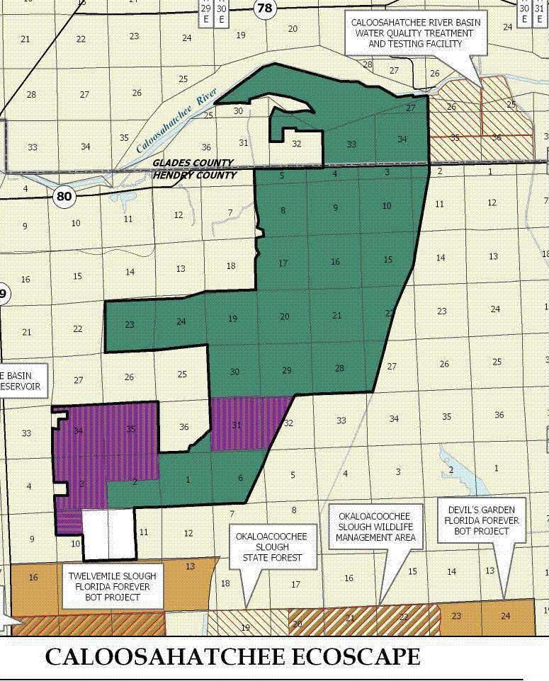
1 October 28, 2009 May 25, 2010 Jim Farr Staff Director, Acquisition and Restoration Council Office of Environmental Services Division of State Lands Florida Department of Environmental Protection 3900 Commonwealth Blvd. MS 100 Tallahassee, FL Re: Florida Forever Priority Ranking Caloosahatchee Ecoscape Project Dear Jim: This letter supports a high numerical ranking for the Caloosahatchee Ecoscape Florida Forever project, for consideration by the Acquisition and Restoration Council (ARC) at their next meeting. Please provide this letter and attachments to the members in advance of that meeting. The Caloosahatchee Ecoscape project lies just east of Labelle, borders the Caloosahatchee River to the north and runs south to approximately the Twelve Mile Slough Florida Forever project. This letter provides in summary fashion a number of reasons why the Caloosahatchee Ecoscape should receive a high numerical ranking and the importance of the ranking to the area s future. The Caloosahatchee Ecoscape is home to a number of endangered or threatened species, including Florida Panther, black bear, sandhill crane, woodstork, crested caracara, and other species that are of concern. If protected, this area would serve as one of the most critical linkages for Florida Panther movement in the state as it encompasses a significant portion of what is considered to be the dispersal zone as established by the US Fish and Wildlife Service. Again, if protected, the Caloosahatchee Ecoscape could provide a true corridor for panther movement from south of the Caloosahatchee River to north of the river. Overall, the area remains in a fairly natural state, but restoration is needed in certain areas to make it more attractive for wildlife, including the panther, and to provide water quality and quantity benefits to the Caloosahatchee River. Unlike many other priority projects of the Florida Forever program, the Caloosahatchee Ecoscape is relatively small, with roughly 15,000 acres. While the number of acres is small in comparison to other projects, the impact of protecting the remaining acreage in the Caloosahatchee Ecoscape would be significant. Recently, the Floriland Dairy property was established as a conservation bank for the Florida Panther, consisting of approximately 4,000 acres. As a result, only 11,000 acres remain to be protected. With a concerted effort and a high numerical Florida Forever ranking, this entire project could be protected in the very near future from any further development or fragmentation. This is critical if the panther dispersal zone is to be protected.
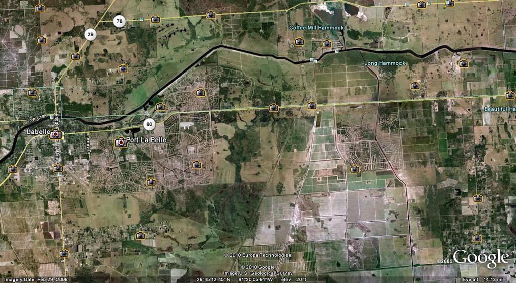
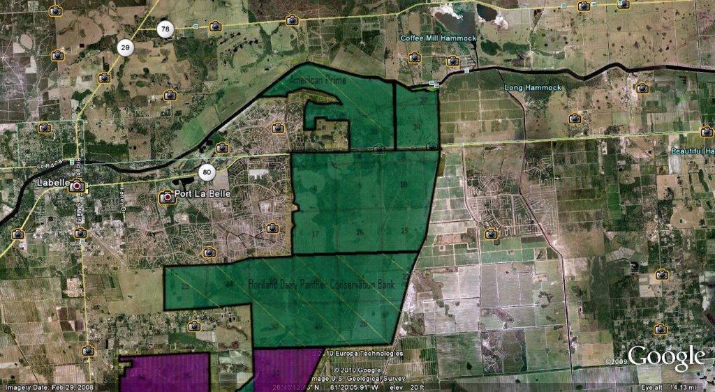
2 Letter to Jim Farr Support for Priority Ranking Caloosahatchee Ecoscape Florida Forever Project May 25, 2010 Page 2 There is a limited window of opportunity to protect the Caloosahatchee Ecoscape, as a result of the downturn in the real estate market, resulting in declining land values. However, prior to the downturn, the Caloosahatchee Ecoscape was under intense development pressure, and will soon be again. Southwest Florida remains a desirable for development. When the real estate market returns, so too will the intense pressures to develop this area. As you will see from a review of the attached exhibits, starting at Fort Myers and heading east through Alva into Labelle along SR 80, development has already occurred. Given the past trends of development along SR 80 and considering the widening and improvement of SR80, it is likely that the development will continue to head east into the Caloosahatchee Ecoscape. Development already borders the Caloosahatchee Ecoscape to the west and southeast. If a concerted effort is not made in the very near future to protect what could become a corridor for panther movement to the north, this area will be further developed, essentially limiting future panther movement and repopulation of the panther to only south of the River. Over the last eight months, we have been working with the owners of American Prime II LLC and The Estates at Port Labelle LLC, both located at the northern end of the Caloosahatchee Ecoscape, to try and achieve a conservation solution for these properties. The two parcels are commonly referred to as the Double Eagle Ranch. The Double Eagle Ranch consists of approximately 1,560 acres and includes almost 3 miles of river frontage along the Caloosahatchee River. The American Prime parcel is considered by many to be the lynchpin property for the dispersal zone. The Double Eagle Ranch was originally purchased in 2004 for development purposes. The larger American Prime parcel is currently under contract and the potential purchaser is pursuing the creation of a panther conservation bank on the property, which would include restoration and would provide additional cover for the panther. As of the date of this letter, the potential purchaser and the USFWS have been working on such a solution and it is hoped that clarity for that use will be confirmed in the next few weeks. Upon receiving that clarity, we expect the potential purchaser to close on the contract and move forward with the creation of the bank. This is an effort we fully support and we are hopeful that USFWS acts quickly and sends written confirmation of the already verbally agreed upon parameters. If such a solution takes place, then the larger portion of the Double Eagle Ranch will be protected, and we can focus our energies on The Estates at Port Labelle parcel. However, in the event the contract for the American Prime parcel does not close, the owner must preserve the ability move forward with other options, including possible development. The owner of the Double Eagle Ranch needs to do something quickly and while we will continue to work with them on a conservation solution, we cannot be certain that this property will not be otherwise sold or developed. While we understand that funding is extremely limited at the time, a high ranking may help to provide a conservation solution in the near future. The Double Eagle Ranch, in its entirety, is significant to the region and the state due to its natural resources, wildlife habitat, geographic location within the panther Dispersal Zone for the Florida Panther and restoration potential. The Double Eagle Ranch has been identified by the Florida Fish and Wildlife Conservation Committee s Environmental Resource Analysis as a Strategic Habitat Conservation Area and has also been identified by The Florida Natural Areas Inventory as a high priority Landscape sized Family Lands Remembered, LLC 801 Maplewood Dr, Suite 8 Jupiter, FL ernie@familylandsremembered.com shane@familylandsremembered.com
3 Letter to Jim Farr Support for Priority Ranking Caloosahatchee Ecoscape Florida Forever Project May 25, 2010 Page 3 Protection Area. With almost 3 miles of river frontage, a restored Double Eagle Ranch could be important to the water quality of the Caloosahatchee River. In addition, The Double Eagle Ranch is considered the lynchpin from a wildlife corridor standpoint as it is one of the last remaining tracts providing direct connectivity to Caloosahatchee River for panthers and other wildlife species. Currently, like many other properties in the Caloosahatchee Ecoscape, the Double Eagle Ranch is being used to graze cattle. The northern portion of the ranch has been classified as improved to semiimproved pasture, primarily covered by bahia grass, dog fennel, ragweed and other grasses. Historically, the northeastern portion of the property was ditched and drained by a previous landowner for agricultural purposes. Based upon its soil types and historical aerial photos, a majority (987 acres) of the property could have been characterized as a freshwater march. Included in this area is also the remnant signature of a historical lake, known as Lake Bonnet. Lake Bonnet has been targeted for restoration by the South Florida Water Management District in the past and feasibility studies have been completed as well. Over the decades, ownership and uses of the area has changed multiple times, altering its natural plant and animal communities. We believe that a great opportunity exists for the Double Eagle Ranch to be protected and then restored, if funding can be arranged quickly. In addition, several agencies including NRCS, Florida Fish and Wildlife Commission and the United States Fish and Wildlife Service and environmental organizations including the Defenders of Wildlife, Audubon of Florida, The Conservancy of Southwest Florida, The Nature Conservancy and many others have expressed interest to try and protect the Double Eagle Ranch and the Caloosahatchee Ecoscape as a whole. As previously mentioned, the property is currently under contract but has not yet closed. We hope the potential purchaser closes on the sale to pursue the Panther Conservation Bank, but a high ranking of this Florida Forever project would provide other alternatives in case the closing does not take place. We hope this information is helpful. Please contact me with any questions or comments. Sincerely, Ernie Cox President cc: Margarita Galiana (with enclosures) Iris Casanova (with enclosures) Enclosures Family Lands Remembered, LLC 801 Maplewood Dr, Suite 8 Jupiter, FL ernie@familylandsremembered.com shane@familylandsremembered.com
4
5
6
Photo by Carlton Ward Jr. Executive Summary
 Photo by Carlton Ward Jr. Executive Summary The Cooperative Conservation Blueprint (Blueprint) is a multi-partner strategic conservation process developed by the Florida Fish and Wildlife Commission (FWC)
FEGN Update Goals and Objectives
 FEGN Update Goals and Objectives Update the FEGN to identify a functionally connected statewide ecological network of public and private conservation lands that incorporates new and updated GIS data. Ensure
Subject: Hendry County Evaluation and Appraisal Report Letter of Understanding - Identification of Major Issues
 HENDRY COUNTY PLANNING & ZONING DEPARTMENT POST OFFICE BOX 2340 165 S. LEE STREET LABELLE, FLORIDA 33975 (863) 675-5240 FAX: (863) 675-5317 SUNCOM 744-4750 November 16, 2007 Mr. Mike McDaniel, Chief Office
Nicole Ryan Governmental Relations Manager Conservancy of Southwest Florida 1450 Merrihue Drive Naples, FL 34102
 P.O. Box 1895, Punta Gorda, FL 33951-1895 Phone/Fax 239.293.7460 www.conservancy.org 7/2/2007 Nicole Ryan Governmental Relations Manager Conservancy of Southwest Florida 1450 Merrihue Drive Naples, FL
M E M O R A N D U M November 9, 2018
 M E M O R A N D U M November 9, 2018 To: Southlake 2035 Corridor Planning Committee From: Kenneth Baker, Sr. Director of Planning and Development Services Subject: Item #8 Up to thirteen (13) residential
September 14, Ken Cunningham, Chief a I. Conservation Services Division ti9 r< New Mexico Department of Game and Fish. P0 Box
 September 14, 2011 j Conservation Services Division ti9 r< Ken Cunningham, Chief a I fl4j Richardson Building www.urscorp.com Fax: 575-526-1390 Phone: 575-526-1180 Las Cruces, NM 88005-2610 101 North Alameda,
DRAFT Subject to Modifications
 TREASURE COAST REGIONAL PLANNING COUNCIL M E M O R A N D U M To: Council Members AGENDA ITEM 5P From: Date: Subject: Staff February 20, 2009 Council Meeting Local Government Comprehensive Plan Review Draft
INTEGRATING PROTECTION OF ECOSYSTEM SERVICES INTO THE PLANNING PROCESS IN FLORIDA
 INTEGRATING PROTECTION OF ECOSYSTEM SERVICES INTO THE PLANNING PROCESS IN FLORIDA Clay Henderson Institute for Water and Environmental Resilience - Stetson University Elizabeth Porter Economics Department,
Darlington Pines 1,295. At a Glance: Property Features. Acreage: 622 +/- acres (Sub-dividable) Asking Price:
 Asking Price:") ONLY $ 1,95 PER ACRE Property Features Located in the fertile northern reaches of Holmes County, Florida, the 6-acre tract has been continuously owned by the Spann family for over 50 years, once serving
ONLY $ 1,95 PER ACRE Property Features Located in the fertile northern reaches of Holmes County, Florida, the 6-acre tract has been continuously owned by the Spann family for over 50 years, once serving
Wisconsin downtown action council Downtown project case study profile
 Wisconsin downtown action council Downtown project case study profile Project Name Onalaska Waterfront Project Location City of Onalaska Project Type (check all that apply) g Residential g Commercial g
M E M O R A N D U M July 27, 2018
 M E M O R A N D U M July 27, 2018 To: Southlake 2035 Corridor Planning Committee From: Kenneth Baker, Sr. Director of Planning and Development Services Subject: Item #6 First National Bank Purpose Review,
TREASURE COAST REGIONAL PLANNING COUNCIL M E M O R A N D U M. To: Council Members AGENDA ITEM 5I
 TREASURE COAST REGIONAL PLANNING COUNCIL M E M O R A N D U M To: Council Members AGENDA ITEM 5I From: Date: Subject: Staff December 12, 2008 Council Meeting Local Government Comprehensive Plan Review Town
ROLE OF LANDSCAPE CONSERVATION COOPERATIVES IN EVERGLADES RESTORATION
 ROLE OF LANDSCAPE CONSERVATION COOPERATIVES IN EVERGLADES RESTORATION GEER April 2017 Steve Traxler 1, Todd Hopkins 1, Beth Stys 2 1 US Fish and Wildlife Service 2 Florida Fish & Wildlife Conservation
Florida Fish And Wildlife Conservation Commission
 Florida Fish And Wildlife Conservation Commission Division of Habitat And Species Conservation Invasive Plant Management Section Upland Invasive Exotic Plant Management Subsection Yet another year!!! Where
Arlington, Virginia is a worldclass
 EXECUTIVE S U M M A RY Arlington maintains a rich variety of stable neighborhoods, quality schools and enlightened land use policies, and received the Environmental Protection Agency s highest award for
Policy & Procedure Effective Date: Parks Department Page of
 City of Arvada Policy & Procedure Effective Date: Parks Department Page of TITLE: City of Arvada Prairie Dog Habitat Plan APPROVAL: PURPOSE: To establish a plan for the preservation of black-tailed prairie
SUMMARY. Support the Southeast Arkansas Regional Intermodal Facility.
 SUMMARY THE I-69 LOCATION STUDY The proposed I-69 Location Study from El Dorado to McGehee, Arkansas, represents one section (Section of Independent Utility No. 13) of the nationally designated I-69 Corridor
TREASURE COAST REGIONAL PLANNING COUNCIL M E M O R A N D U M. February 19, 2010 Regional Planning Council Meeting
 TREASURE COAST REGIONAL PLANNING COUNCIL M E M O R A N D U M To: Council Members AGENDA ITEM 5H From: Date: Subject: Staff February 19, 2010 Regional Planning Council Meeting Local Government Comprehensive
3.10 LAND USE SETTING PROJECT SITE EXISTING LAND USE DESIGNATIONS AND ZONING. General Plan Land Use Designations.
 This section of the Draft EIR addresses the existing land uses on and adjacent to the project site and discusses the potential impacts of the proposed project on existing land uses. Key issues addressed
Office of Greenways & Trails Providing Statewide Leadership and Coordination. Southeast Greenways and Trails Summit October 1-3, 2017
 Office of Greenways & Trails Providing Statewide Leadership and Coordination Southeast Greenways and Trails Summit October 1-3, 2017 1 Office of Greenways and Trails The Office of Greenways and Trails
Towne Park Estates Subdivision Phase II
 Towne Park Estates Subdivision Phase II ENVIRONMENTAL NARRATIVE October 21, 2014 Submitted to: Submitted by: Horner Environmental Professionals, Inc. 4252 Hay Road Lutz, Florida 33559 HEP TOWNE PARK ESTATES
ELIGIBILITY CRITERIA CHECKLIST OPEN SPACE CLASSIFICATION
 THURSTON COUNTY DEVELOPMENT SERVICES OPEN SPACE TAX PROGRAM ELIGIBILITY CRITERIA CHECKLIST OPEN SPACE CLASSIFICATION Use this checklist to help you determine whether your property is eligible for open
Florida Forever Conservation Needs Assessment Overview Maps
 Florida Forever Conservation Needs Assessment Overview Maps Prepared by Florida Natural Areas Inventory, The maps in this document are derived from the Florida Forever Conservation Needs Assessment, an
North Carolina Department of Transportation Project Development and Environmental Analysis Branch
 North Carolina Department of Transportation Project Development and Environmental Analysis Branch Citizens Informational Workshop I-85, from I-485 to NC 73 Mecklenburg and Cabarrus Counties October 30,
RECREATION AND OPEN SPACE ELEMENT GOALS, OBJECTIVES, AND POLICIES
 RECREATION AND OPEN SPACE ELEMENT GOALS, OBJECTIVES, AND POLICIES Goal 7 To provide park facilities, recreation programs, and open space resources that are safe, adequate, and accessible to all City residents,
Mendota-Lebanon Hills Greenway Master Plan Executive Summary. August draft for more information visit
 Mendota-Lebanon Hills Greenway Master Plan Executive Summary August 2013 draft for more information visit www.hkgi.com/projects/dakota INTRODUCTION The Mendota-Lebanon Hills Greenway Master Plan portrays
Chapter 5: Natural Resources and Environment
 NATURAL RESOURCES AND ENVIRONMENT 5-1 5 Chapter 5: Natural Resources and Environment BACKGROUND AND INTENT Urban expansion represents the greatest risk for the future degradation of existing natural areas,
Support the implementation of Cape Coral's Comprehensive Plan. Protect and utilize the unique natural resources in the City.
 7.0 OVERVIEW - RECOMMENDATIONS Chapter 7 The preparation of the Cape Coral Parks and Recreation Master Plan spanned a period of approximately 12 months. Plan preparation included the input of a wide range
DRAFT MAP AMENDMENT FLU 04-4
 DRAFT MAP AMENDMENT FLU 04-4 SW 24 TH AVENUE ROADWAY CORRIDOR The University of Florida participates with the Metropolitan Transportation Planning Organization (MTPO) in its responsibilities for the continuing,
Courthouse Planning Area
 Courthouse Planning Area Current Reality The Courthouse Planning Area is the characterized by expansive suburbanscale residential areas as well as the community resource planned area of athletic, educational,
Gadsden County Planning Commission Agenda Request
 Date of Meeting: November 16, 2017 To: From: Through: Subject: Gadsden County Planning Commission Agenda Request Honorable Chairperson and Members of the Board Jill A. Jeglie, AICP, Senior Planner Clyde
Integration of Planning & Environmental Analysis in Transportation
 Integration of Planning & Environmental Analysis in Transportation How Natural Resources Conservation Fits into SAFETEA-LU Planning Rules Transportation Research Board Annual Meeting January 2008 Jeff
2.0 Hi s t o r y & Existing Co n d i t i o n s
 2.0 Hi s t o r y & Existing Co n d i t i o n s 2.1 Plan Area History The Lincoln East Specific Plan (Specific Plan) area is a significant part of the history of Sutter County. A 48,000 acre land grant
Pinellas County Greenways
 Pinellas County Greenways USING GREENWAYS TO LINK OPEN SPACES The Florida Greenways Commission has defined a greenway as...a corridor of protected open space that is managed for conservation and/or recreation.
RECREATION, OPEN SPACE AND GREENWAYS ELEMENT GOALS, OBJECTIVES, AND POLICIES
 RECREATION, OPEN SPACE AND GREENWAYS ELEMENT GOALS, OBJECTIVES, AND POLICIES GOAL R-1: DEVELOP A RECREATION, OPEN SPACE AND GREENWAYS SYSTEM AS AN INTEGRAL COMPONENT OF AN OVERALL, COUNTY-WIDE ECONOMIC
DISCUSSION TOPIC: ST JOHNS RIVER & ITS TRIBUTARIES (BPII) 2030 COMPREHENSIVE PLAN POLICES AND REGULATORY FRAMEWORK
 2030 COMPREHENSIVE PLAN POLICES AND REGULATORY FRAMEWORK") DISCUSSION TOPIC: ST JOHNS RIVER & ITS TRIBUTARIES (BPII) 2030 COMPREHENSIVE PLAN POLICES AND REGULATORY FRAMEWORK St. John s River & Its Tributaries Issue Summary: The St. Johns River is an important
DISCUSSION TOPIC: ST JOHNS RIVER & ITS TRIBUTARIES (BPII) 2030 COMPREHENSIVE PLAN POLICES AND REGULATORY FRAMEWORK St. John s River & Its Tributaries Issue Summary: The St. Johns River is an important
12 Intergovernmental Coordination
 Intergovernmental Coordination Supporting Data The purpose of the Intergovernmental Coordination Element is to identify and resolve incompatible goals, objectives, policies and development proposed in
Master Plan Objectives and Policies
 Master Plan Objectives and Policies Introduction This chapter identifies the Park issues and recommended policies established by this Master Plan. The issues were identified through meetings with staff,
Stone Soup Conservation Responding to Landscape Challenges in the Eastern Tallgrass Prairie & Big Rivers Landscape Conservation Cooperative (LCC)
") Stone Soup Conservation Responding to Landscape Challenges in the Eastern Tallgrass Prairie & Big Rivers Landscape Conservation Cooperative (LCC) Glen Salmon & Dr. Gwen White Eastern Tallgrass Prairie
Stone Soup Conservation Responding to Landscape Challenges in the Eastern Tallgrass Prairie & Big Rivers Landscape Conservation Cooperative (LCC) Glen Salmon & Dr. Gwen White Eastern Tallgrass Prairie
Appendix E Section 4(f) Evaluation
 Evaluation") Appendix E Section 4(f) Evaluation Appendix E Draft Section 4(f) Evaluation E.1 Introduction This appendix addresses a federal regulation known as Section 4(f), which protects parks, recreation areas,
Appendix E Section 4(f) Evaluation Appendix E Draft Section 4(f) Evaluation E.1 Introduction This appendix addresses a federal regulation known as Section 4(f), which protects parks, recreation areas,
Rural Conservation. Rural Conservation. Moving Forward ~ Planning Ahead. Introduction
 Introduction Minnehaha County expresses at least two very different styles of character. The City of Sioux Falls provides a strong urban atmosphere because of its size and regional status, and the unincorporated
Suited for Light Industrial & Manufacturing ± 343 Acres in Denton High Traffic Counts & Visibility
 Light Industrial / Manufacturing Masch Branch & Hampton Rd Suited for Light Industrial & Manufacturing ± 343 Acres in Denton High Traffic Counts & Visibility 1400 Dallas Dr. 940.390.1927 jimmy.terrell@sbpcommercial.com
Figure 1. Proposed Strategic Habitat Conservation Areas for Florida
 Figure 1. Proposed Strategic Habitat Conservation Areas for Florida Critical Lands and Waters Identification Project (CLIP) Cooperative Effort Century Commission for Sustainable Florida Florida Natural
Ada SWCD (Boise, Idaho) Partnership Outreach Strategy. NACD Urban & Community RPG Webinar September 20, 2012 Scott Koberg - Ada SWCD Manager
 Partnership Outreach Strategy. NACD Urban & Community RPG Webinar September 20, 2012 Scott Koberg - Ada SWCD Manager") Locally Led in Developing Areas: Ada SWCD (Boise, Idaho) Partnership Outreach Strategy NACD Urban & Community RPG Webinar September 20, 2012 Scott Koberg - Ada SWCD Manager Survive or Thrive? You can t
Locally Led in Developing Areas: Ada SWCD (Boise, Idaho) Partnership Outreach Strategy NACD Urban & Community RPG Webinar September 20, 2012 Scott Koberg - Ada SWCD Manager Survive or Thrive? You can t
ORANGE COUNTY IMPLEMENTING THE FOUR C s
 ORANGE COUNTY IMPLEMENTING THE FOUR C s East Central Florida Corridor Task Force O R A N G E COUN TY P LA N N I N G DIVISION C O M M U N I T Y, E N V I R O N M E N T A L A N D D E V E L O P M E N T S E
An Update on the Air Force Pilot Project: Developing the Florida Strategic Plan for Sustaining Military Readiness through Conservation Partnerships
 An Update on the Air Force Pilot Project: Developing the Florida Strategic Plan for Sustaining Military Readiness through Conservation Partnerships 18 November 2015 Quick Overview Pilot Project Background
The Development of Riparian Stream Buffers in Greensboro, NC
 The Development of Riparian Stream Buffers in Greensboro, NC Why our stream banks have grown up? Presented by: Peter Schneider, Water Quality Supervisor City of Greensboro Stormwater Management Division
Phase I Ecological Network Report Terms of Reference
 Phase I Ecological Network Report Terms of Reference INTRODUCTION In 2007, the City of Edmonton created a new Natural Area Systems Policy (C-531) and a strategic plan, Natural Connections. Together, these
Dwelling Units Max 12 dwelling units per acre/min 8 dwelling units per acre. Development Mix 80% non residential/20% residential
 13. OSTEEN LOCAL PLAN Background: The Osteen Local Plan area is located in southwest Volusia County along the SR 415 corridor between Lemon Bluff Road and Acorn Lake Road and includes 3,990 acres. The
Community Conservation Workshop. Lake Placid
 Community Conservation Workshop Lake Placid 2 Community Conservation Program Welcome! We have designed a Community Conservation Program that listens to the needs of community members. We are conducting
Preface. Erie. Scranton. Allentown. Pittsburgh. Harrisburg. Philadelphia
 The Southern Alleghenies Region The Southern Alleghenies Region spans the Laurel Highlands and Allegheny Front in the west across the Appalachians to the east. It is comprised of Blair, Bedford, Cambria,
MEMORANDUM OF BOG TURTLE HABITAT INVESTIGATION
 MEMORANDUM OF BOG TURTLE HABITAT INVESTIGATION 410-728-2900 Fax: 410-728-3160 www.rkk.com To: From: CC: U.S. Fish and Wildlife Service, Pennsylvania Fish and Boat Commission Jennifer A Ottenberg Miller,
AWH REPORT OF THE PLANNING AND DEVELOPMENT DEPARTMENT FOR APPLICATION FOR REZONING ORDINANCE TO PLANNED UNIT DEVELOPMENT
 AWH REPORT OF THE PLANNING AND DEVELOPMENT DEPARTMENT FOR APPLICATION FOR REZONING ORDINANCE TO PLANNED UNIT DEVELOPMENT MAY 8, 2014 The Planning and Development Department hereby forwards to the Planning
Mitchell Ranch South MPUD Application for Master Planned Unit Development Approval Project Narrative. Introduction
 Mitchell Ranch South MPUD Application for Master Planned Unit Development Approval Project Narrative Introduction Mitchell Ranch South is a proposed single family (detached) residential development on
TOWN OF BETHLEHEM OPEN SPACE CONSERVATION PLAN PUBLIC MEETING: OCTOBER 12, 2017
 TOWN OF BETHLEHEM OPEN SPACE CONSERVATION PLAN PUBLIC MEETING: OCTOBER 12, 2017 Welcome and Agenda 6:00 6:45: Open House, Part One 6:45 7:15: Presentation and Questions 7:15 8:00: Open House, Part Two
Rural Land Use Designations Kittitas County December 6, 2007 Draft
 KITTITAS COUNTY COMMUNITY DEVELOPMENT SERVICES 411 N. Ruby St., Suite 2, Ellensburg, WA 98926 CDS@CO.KITTITAS.WA.US Office (509) 962-7506 Fax (509) 962-7682 Rural Land Use Designations Kittitas County
OCEANSIDE DEVELOPER S CONFERENCE
 1 AGENDA OCEANSIDE DEVELOPER S CONFERENCE Tuesday, November 15th, 2016, 8:30 a.m. City Hall South, 1 st Floor, Guajome Room 1. 8:30-9:30 a.m. Proposed 57 lot residential subdivision of an approximately
RACER Properties in Pontiac
 RACER Properties in Pontiac Bruce Rasher, Redevelopment Manager brasher@racertrust.org Pontiac, MI Fiero Assembly Plant Pontiac North Campus Industrial Land Fiero Powerhouse 2017 Google Pontiac North Campus
CHARLES COUNTY GOVERNMENT RFP NO POPES CREEK RAIL TRAIL DESIGN
 CHARLES COUNTY GOVERNMENT Department of Fiscal and Administrative Services Purchasing Division Telephone: 301-645-0656 July 7, 2015 RFP NO. 16-02 POPES CREEK RAIL TRAIL DESIGN ADDENDUM NUMBER ONE TO: All
13. PRELIMINARY PLAT NO MILLS FARM - Vicinity of the southeast corner of 159 th Street and Quivira Road
 13. corner of 159 th Street and Quivira Road 1. APPLICANT: HNTB Corporation is the applicant for this request. 2. REQUESTED ACTION: The applicant is requesting approval of a preliminary plat for a 383-lot
North Ranch Master Plan
 North Ranch Master Plan Presentation to: East Central Florida Corridor Task Force Presentation by: Osceola County Office of Strategic Initiatives and Deseret Ranches Planning Team Kissimmee, Florida Friday,
Planning & Zoning Commission Staff Report
 Planning & Zoning Commission Staff Report Meeting Date: May 26, 2015 Drafted by: Katherine Harrison-Rogers CASE # Z2886 PROJECT NAME: APPLICANT/ REPRESENTATIVE: Shawna Runyan PROPERTY OWNER: 1840 (previously
KEEPING IT GREEN IN THE MIDLANDS: Preserving Open Space in South Carolina s Capitol Region
 KEEPING IT GREEN IN THE MIDLANDS: Preserving Open Space in South Carolina s Capitol Region Introduction The Central Midlands Council of Governments (CMCOG) has been working to produce a concept document
Northern Branch Corridor SDEIS March 2017
 Northern Branch Corridor SDEIS March 2017 15. 15.1. Chapter Overview 15.1.1. Introduction This chapter discusses changes to the Preferred Alternative resulting in the potential for project improvements
III. PROJECT DESCRIPTION
 III. PROJECT DESCRIPTION A. PROJECT LOCATION Regional Setting The project site is located in the southeast quadrant of the City of Chico in Butte County, California and is comprised of four parcels totaling
50-year Water & Wetland Vision for England WORKSHOP DETAILS
 50-year Water & Wetland Vision for England Workshop 3: Wetland vision maps; your feedback on draft maps, methodology and ways forward 7 th December 2006 WORKSHOP DETAILS Theme 1: Methodology and prioritisation
Town of Rico Three Mile Plan for Annexation
 Town of Rico Three Mile Plan for Annexation 10.20.2010 Adopted by Resolution 2010-2 Produced with funding support from the Colorado Department of Local Affairs 2 Content Guide Introduction. 3 Annexation
A project of the Arizona State Land Department,/ facilitated by East Valley Partnership & Pinal Partnership
 A project of the Arizona State Land Department,/ facilitated by East Valley Partnership & Pinal Partnership September 4, 2008 Ms. Peggy Fiandaca Pinal County Comprehensive Plan 13771 Fountain Hills Blvd.,
NJ Habitat Connectivity Initiative
 NJ Habitat Connectivity Initiative Full Working Group Update #1 Spotted Salamander Crossing Road in Northern NJ Wildlife Habitat Connectivity Initiative A strategic plan to reconnect New Jersey s landscape
PURPOSE AND NEED FOR ACTION PUBLIC SCOPING LETTER SILVER GLEN SPRINGS RECREATION ENHANCEMENT PROJECT. Ocala National Forest
 File Code: 1950/2300/2720 PUBLIC SCOPING LETTER SILVER GLEN SPRINGS RECREATION ENHANCEMENT PROJECT Lake George Ranger District Marion County, Dear Visitor: The of the has developed a proposal (Proposed
KITT PEAK LINKAGE WILDLIFE CONNECTIVITY: WILDLIFE OVERPASSES AND FENCING. State Route 86
 KITT PEAK LINKAGE WILDLIFE CONNECTIVITY: WILDLIFE OVERPASSES AND FENCING State Route 86 Tohono O odham Nation Department of Natural Resources Wildlife and Vegetation Management Program In partnership with
SITE SUMMARY REPORT Arlington Dump NONCD Yadkin County
 SITE SUMMARY REPORT Arlington Dump NONCD 0000644 Yadkin County Hurricane Recovery Act of 2005 State of North Carolina State Contract N06009S Schnabel Project No. 06210002.15 July 31, 2009 Prepared for:
COLLIER BOULEVARD (CR 951) CORRIDOR
 CORRIDOR") Project(s) Goals Improve Traffic Circulation, Capacity & Safety Focus on Safety During Design & Construction Address Public Concerns Design an Aesthetically Pleasing Project Limit Environmental Impacts
Project(s) Goals Improve Traffic Circulation, Capacity & Safety Focus on Safety During Design & Construction Address Public Concerns Design an Aesthetically Pleasing Project Limit Environmental Impacts
Project Description WOO/LUC-SR /0.00. Waterville Bridge Replacement
 Ohio Department of Transportation District 2 317 East Poe Rd. Bowling Green, Ohio 43402 (419) 353-8131 John R. Kasich, Governor Jerry Wray, Director Todd Audet, P.E., District Deputy Director Project Description
Wide-ranging Species Conservation
 Wide-ranging Species Conservation The overwhelming message from population viability studies of large carnivores is that conservation planning must be undertaken at vast spatial scales and must consider
LAND USE MEADOWS PLANNING AREA
 LAND USE MEADOWS PLANNING AREA I. Profile of Meadows Planning Area A. Location Meadows Planning Area is delineated by I-5 on the north, the Nisqually Bluffs representing the growth boundary on the east,
METROPOLITAN COUNCIL 390 North Robert Street, St. Paul, MN Phone (651) ; TDD (651)
 ; TDD (651)") DATE: December 20, 2011 METROPOLITAN COUNCIL 390 North Robert Street, St. Paul, MN 55101 Phone (651) 602-1000; TDD (651) 291-0904 TO: Metropolitan Parks and Open Space Commission FROM: Tori Dupre, Senior
DATE: December 20, 2011 METROPOLITAN COUNCIL 390 North Robert Street, St. Paul, MN 55101 Phone (651) 602-1000; TDD (651) 291-0904 TO: Metropolitan Parks and Open Space Commission FROM: Tori Dupre, Senior
Rosemount Greenway Master Plan Executive Summary. draft. Spring for more information visit
 Rosemount Greenway Master Plan Executive Summary Spring 2012 draft for more information visit www.hkgi.com/projects/dakota INTRODUCTION The Rosemount Greenway Master Plan portrays a vision to establish
Sierra Club Comments on ACOE Public Notice NAE Re: Proposed Town Neck Beach Project at Sandwich, Massachusetts
 August 27, 2015 US Army Corps of Engineers New England District 696 Virginia Road Concord, MA 01742-2751 Attn: Phillip W. Nimeskern Dear Mr. Nimeskern, Sierra Club Comments on ACOE Public Notice NAE-2014-259
PD&E STUDY SR 9/I-95 FROM SOUTH OF SR 870/COMMERCIAL BOULEVARD TO NORTH OF CYPRESS CREEK ROAD FM # ETDM 14222
 PD&E STUDY SR 870/COMMERCIAL BOULEVARD TO NORTH OF CYPRESS CREEK ROAD FM # 435808-1-22-02 ETDM 14222 WELCOME TO THE KICK-OFF MEETING May 24, 2016 1 1 2 3 4 5 6 PLANNING PROJECT DEVELOPMENT AND ENVIRONMENT
continues in the watershed, additional flood control and water quality / natural system improvements may be required in the future.
 The Duck Pond Watershed is located in northern Hillsborough County in an area in which a number of land and water management issues are currently being addressed by citizen's action groups and state, regional
Wisconsin NRCS Direct Volume Method Bank Recession Rate Categorizations
 2 Executive Summary The City of Ramsey contracted the Anoka Conservation District to complete an inventory of riverbank condition along the entire 5.8 miles of City that border the Mississippi River. The
STEWARDSHIP OF LONG ISLAND SOUND S ECOLOGICAL AND RECREATIONAL RESOURCES
 STEWARDSHIP OF LONG ISLAND SOUND S ECOLOGICAL AND RECREATIONAL RESOURCES Robin Kriesberg, Save the Sound, Inc. Thomas Halavik, US Fish and Wildlife Service Coastal Program An Initiative to Identify, Protect
SH 199 Corridor Master Plan. Community Meeting No. 2 May 31, 2017
 Community Meeting No. 2 May 31, 2017 Transportation Projects On or Near SH 199 SH 199 from 0.3 miles south of FM 1886 to south end of Lake Worth bridge Construct freeway mainlanes and frontage roads 10-Year
Public Hearing. Charlotte County-Punta Gorda MPO - Meeting Rooms A and B March 14, open house at 4 p.m., formal presentation at 5 p.m.
 Public Hearing Charlotte County-Punta Gorda MPO - Meeting Rooms A and B March 14, 2019 open house at 4 p.m., formal presentation at 5 p.m. Welcome to the Public Hearing for the Harborview Road (CR 776)
Public Review Draft Encinitas Subarea Plan
 Encinitas Subarea Plan Prepared for City of Encinitas Community Development Department 505 S. Vulcan Encinitas, California 92024 Prepared by Ogden Environmental and Energy Services Co., Inc. 5510 Morehouse
Public Information Meeting
 Lavon Lake Master Plan Revision Public Information Meeting March 10, 2015 Presented By Michael Kinard Lake Manager U.S. Army Corps of Engineers Fort Worth District US Army Corps of Engineers Purpose of
GREEN SHEET ENVIRONMENTAL COMMITMENTS FOR THE IOWA HIGHWAY 100 EXTENSION
 County: Linn County, IA GREEN SHEET Location: IA 100, from its terminus at Edgewood Rd. to US 30 southwest of Cedar Rapids Route: IA 100 Extension Project No.: NHS-100-1(36) 19-57 OLE Project Managers:
Public Visioning City of Kelso Planning Commission
 Shoreline Master Program Update Public Visioning City of Kelso Planning Commission November 13, 2012 Schedule Jurisdiction Inventory Analysis Visioning Topics Process Governing Principles Structure of
Portage County Parks, Trails and Greenways Plan
 Portage County Parks, Trails and Greenways Plan Agenda for Local Planning Meeting Introductory Presentation Why we need a Plan Plan project goals and process Benefits Overview of local planning region
LAKE COUNTY REGIONAL TRAIL PROJECTS
 LAKE COUNTY REGIONAL TRAIL PROJECTS LAKE APOPKA LOOP TRAIL SOUTH LAKE TRAIL LEESBURG-WILDWOOD TRAIL LAKE-CROSS FLORIDA GREENWAY LAKE LOUISA-HORIZON WEST WEKIVA PARKWAY- SR 46 CORRIDOR SR 40 CORRIDOR VAN
STATE OF TENNESSEE DEPARTMENT OF TRANSPORTATION ENVIRONMENTAL DIVISION
 STATE OF TENNESSEE DEPARTMENT OF TRANSPORTATION ENVIRONMENTAL DIVISION Suite 900 - James K. Polk Building 505 Deaderick Street Nashville, Tennessee 37243-0334 MEMORANDUM TO: FROM: Files Joe W. Matlock,
Joe Pool Lake Lake Master Plan Public Information Meeting Presentation of Final Draft Revision July 31, 2018
 Joe Pool Lake Lake Master Plan Public Information Meeting Presentation of Final Draft Revision July 31, 2018 Presented By Jeremy Spencer Lake Manager U.S. Army Corps of Engineers Fort Worth District US
PARK PLANNING & STEWARDSHIP DIVISION
 MCPB Item # July 30, 2015 MEMORANDUM July 23, 2015 TO: Montgomery County Planning Board VIA: FROM: Mike Riley, Director of Parks Mitra Pedoeem, Acting Deputy Director of Parks John E. Hench, Ph.D., Chief,
Canyon Lake Master Plan Revision Public Information Meeting March 18, 2016
 Canyon Lake Master Plan Revision Public Information Meeting March 18, 2016 Marcus Schimank Canyon Lake Manager Capital Regional Office U.S. Army Corps of Engineers Fort Worth District US Army Corps of
We d like to thank you for attending this Wekiva Parkway Section 8 Preliminary Design Update hosted by the Florida Department of Transportation.
 We d like to thank you for attending this Wekiva Parkway Section 8 Preliminary Design Update hosted by the Florida Department of Transportation. We will provide you information on the overall project and
Green Infrastructure Policies and Ordinances
 Green Infrastructure Policies and Ordinances October 23, 2013 By Karen Firehock, Green Infrastructure Center 2013 Georgia Urban Forest Council s 23 rd Annual Conference The mission of the nonprofit Green
SUNBRIDGE PARKWAY PRELIMINARY DESIGN STUDY. Board of County Commissioners Public Hearing
 SUNBRIDGE PARKWAY PRELIMINARY DESIGN STUDY Board of County Commissioners Public Hearing March 20, 2018 Presentation Overview Study Overview Existing Conditions Project Development Plan Public Involvement
Peninsular Florida Landscape Conservation Cooperative. Marine and Estuarine Priority Resources and Conservation Targets
 Peninsular Florida Landscape Conservation Cooperative Marine and Estuarine Priority Resources and Conservation Targets Why are we here today? Workshop Goals: Develop a list of potential conservation targets
This page intentionally blank.
 This page intentionally blank. Parks, Recreation, and Open Space Chapter Relationship to Vision Vision Parks, Recreation and Open Space Chapter Concepts County Government. County government that is accountable