VILLA D ESTE JSP17-52 with Rezoning
|
|
|
- Patrick Benson
- 5 years ago
- Views:
Transcription
1 VILLA D ESTE JSP17-52 with Rezoning VILLA D ESTE JSP17-52 WITH REZONING Public hearing at the request of Cambridge of Novi, LLC for Planning Commission s Recommendation to City Council for a Planned Rezoning Overlay Concept Plan associated with a Zoning Map amendment, to rezone from RA (Residential Acreage) to R-1 (One-Family Residential). The subject property is approximately 51 acres and is located east of Napier Road and on the north side of Nine Mile Road (Section 29, 30). The applicant is proposing a 56-unit single-family housing development (for sale). Required Action Recommendation to the City Council for approval or denial of rezoning request from RA (Residential Acreage) to R-1 (One-Family Residential) with a Planned Rezoning Overlay at another Public hearing. REVIEW RESULT DATE COMMENTS Planning Engineering Landscaping Traffic Approval recommended Approval recommended Approval recommended Approval recommended (Revised) (Revised) (Revised) (Revised) Request to waive site condominium review to allow for overall modifications to all applicable minimum lot size, lot shape, lot frontage, setbacks and lot coverage. Blocks longer than 1400 feet. Items to be addressed by the applicant prior to Concept Plan approval Absence of stub street to the property boundary at intervals not to exceed 1,300 feet along the perimeter. Not providing non-paved eyebrows. Absence of sidewalk along the portion of the south side of Villa Drive and the west side of Villa D Este Blvd. The outside edge of sidewalk should be located a minimum of 15 feet from the back of curb Items to be addressed by the applicant prior to Concept Plan approval The required berm is not proposed along the western section of the project s Nine Mile Road frontage. The required berm is not proposed west of the entrance, in the eastern section of the project s Nine Mile Road frontage. Items to be addressed by the applicant prior to Concept Plan approval Applicant to modify the entry driveway dimensions for approach width, turning radii, and island length to match the City requirements; Horizontal curve radii throughout the site that fall below the minimum required horizontal curve radii.
2 Traffic Study Wetlands Woodlands Façade Fire Approval recommended Approval recommended Approval not currently recommended Not applicable Approval recommended Items to be addressed by the applicant prior to Concept Plan approval Items to be addressed by the applicant prior to Concept Plan approval Items to be addressed by the applicant prior to Concept Plan approval (Revised) (Revised) (Revised) Off-site placement of woodland replacement trees adjacent to Garfield Road, Nine Mile Road and on ITC easements Upsizing of woodland replacement credits Deviation from woodland replacement diversity requirements Defer the submittal of Tree survey to Preliminary Site Plan Submittal Items to be addressed by the applicant prior to Concept Plan approval Request to limit the boundary to calculate the requirements for similar dissimilar review to the proposed project development boundary. Did not perform a review due to insufficient information. Preliminary comments provided as part of Planning review Additional comments to be addressed with next submittal
3 MOTION SHEET Recommend Approval In the matter of Villa D este JSP17-52 with rezoning , motion to recommend approval to the City Council to rezone the subject property from RA (Residential Acreage) to R-1 (One-Family Residential) with a Planned Rezoning Overlay Concept Plan, based on the following: 1. The recommendation shall include the following ordinance deviations for consideration by the City Council: a. Planning Deviation from Sec of Zoning Ordinance for reduction of the minimum lot size, setbacks, minimum lot frontage and minimum site acreage as shown on the proposed concept plan provided, i. The proposed unit boundary shown on the concept plan (sheet 02) is to be considered the maximum allowable footprint. Any accessory uses such as hot tubs, patios, etc. will be provided within the footprint shown on the plan. ii. iii. A minimum of 15 feet shall be maintained between two buildings. A minimum of 30 feet is provided between the front façade and the back of the curb b. Façade deviation from Sec 3.7, similar dissimilar ordinance, to limit the boundary for the calculations of the requirements for similar dissimilar review to the proposed project development boundary. c. Landscape deviation from Sec B.ii and iii of Zoning Ordinance for lack of berms along the westerly Nine Mile Road frontage and portions of the easterly frontage, due to existing natural features; d. Landscape deviation from Section 4 of Landscape Design Manual for not meeting the minimum diversity requirements for woodland replacement plantings along ITC corridor; e. Landscape deviation from Section 7b of Landscape Design Manual for allowing additional credits for upsizing woodland replacement trees as listed below 6-8 Evergreens 1 Credit Evergreens 2 Credits 4 Deciduous Trees 2 Credits Sub canopy 1 Credit f. City Council variance from Sec. 4.04, Article IV, Appendix C-Subdivision ordinance of City Code of Ordinances for absence of a stub street required at 1,300 feet intervals along the property boundary to provide connection to the adjacent property boundary, due to conflict with existing wetlands; g. City Council variance from Chapter 7(c)(1) of Engineering Design manual for reducing the distance between the sidewalk and back of the curb. A minimum of 7.5 feet can be supported by staff; h. City Council variance from Section (8) for absence of non-paved eyebrows;
4 i. City Council variance from absence of sidewalk along a portion of Villa Drive requires a variance, with payment into the City s sidewalk fund for the cost of the sidewalk not constructed; j. A traffic deviation for not meeting the minimum required horizontal curve radii for the proposed streets; 2. If the City Council approves the rezoning, the Planning Commission recommends the following conditions be requirements of the Planned Rezoning Overlay Agreement: a. The development shall be limited to a maximum density, to be determined at the Planning Commission meeting of 56 units. b. The proposed unit boundary shown on the concept plan (sheet 02) is to be considered the maximum allowable footprint. Any accessory uses such as hot tubs, patios, etc. will be provided within the footprint shown on the plan. c. A minimum of 15 feet shall be maintained between any two buildings. d. A minimum of 30 feet shall be provided between the front façade and the back of the curb. e. The applicant shall work with staff to identify a proper location to connect to ITC trail, beyond the subject property line. f. The applicant shall limit the wetland and woodland impacts to the areas and percentages indicated on the concept plan at the time of Preliminary Site Plan. g. Minor modifications to the approved Planned Rezoning Overlay Concept Plan (PRO) can be approved administratively, upon determination by the City Planner, that the modifications are minor, do not deviate from the general intent of the approved PRO Concept plan and result in reduced impacts on the surrounding development and existing infrastructure. h. Applicant shall comply with the conditions listed in the staff and consultant review letters. 3. While the applicant has addressed some of the concerns highlighted in the staff and consultant review letters, there are a number ongoing concerns by staff, primarily the density proposed with the housing pattern so closely spaced, the provision of a comparable plan (using the RA density) as previously requested by the Planning Commission but not provided, details of the likely woodland impacts (which the applicant wishes to address at the time of Preliminary Site Plan Review), and the deviations requested with regard to the off-site replacement additional credits for upsizing and to waive the diversity requirement. This motion is made because 1. The applicant has presented a reasonable alternative to the Master Plan for Land Use recommendation of 0.8 units to the acre (1.43 units to the acre proposed) for the parcel as indicated in the applicant s letter dated August 2, 2017, noting the appropriateness of a empty-nester residential development for the site given the layout of the plan, the proposed preservation of open space, the offer to provide an enhancement to public park facilities, and the provision for landscape or open space buffering on most sides of the development. 2. The proposed plan meets several objectives of the Master Plan, as noted later in this review letter, including: a. Maintain the semi-rural character of the southwest quadrant of the City that is created by low-density residential development and undeveloped land (by protecting a majority of natural features on site and provides ample screening from Nine Mile Road.
5 b. Provide a wide range of housing options (by being geared towards empty nesters, or those wishing to downsize from larger homes. c. Protect and maintain the City s woodlands, wetlands, water features, and open space (by proposing to donate about 18 acres (35%) of land with regulated woodlands and wetlands in the rear). 3. The City s Traffic Engineering Consultant has reviewed the Rezoning Traffic Impact Study and found that the proposed senior adult housing would produce 183 less trips per day than 40 single-family homes (as expected to be permitted under the RA zoning district, and the number of trips produced by the senior adult housing development is not expected to significantly impact Nine Mile Road. 4. Submittal of a Concept Plan and any resulting PRO Agreement, provides assurance to the Planning Commission and to the City Council of the manner in which the property will be developed, and offers benefits that would not be likely to be offered under standard development options. 5. (Additional reasons here if any). -OR- Recommend Denial In the matter of Villa D este JSP17-52 with rezoning , motion to recommend denial to the City Council to rezone the subject property from RA (Residential Acreage) to R-1 (One-Family Residential) with a Planned Rezoning Overlay Concept Plan, based on the followings: a. The proposed rezoning is not consistent with the recommendations of 2016 Master Plan for Land Use. b. (Additional reasons here if any).
6 MAPS Location Zoning Future Land Use Natural Features
7 VILLAD ESTEJSP17-52WITHREZONING Location LEGEND Sections Subject Property Nine Mile Road Cityof Novi Dept.ofCom m unity Developm ent City Hall /CivicCenter 45175W T en MileRd Novi,MI48375 cityofnovi.org Garfield Road Map Author:SriKom aragiri Date:10/30/17 Project:VILLAD EST EJSP17-52WIT HREZONING Version #:1 Feet inch = 378 feet MAP INTERPRETATION NOTICE I Map information depicted is not intended to replace or substitute for any official or primary source. This map was intended to meet National Map Accuracy Standards and use the most recent, accurate sources available to the people of the City of Novi. Boundary measurements and area calculations are approximate and should not be construed as survey measurements performed by a licensed Michigan Surveyor as defined in Michigan Public Act 132 of 1970 as amended. Please contact the City GIS Manager to confirm source and accuracy information related to this map.
8 VILLAD ESTEJSP17-52WITHREZONING Zoning R-1 LEGEND R-A: Residential Acreage R-1: One-Family Residential District Subject Property RA Nine Mile Road RA CityofNovi Dept.ofCom m unity Developm ent City Hall /CivicCenter 45175W T en MileRd Novi,MI48375 cityofnovi.org RA Garfield Road RA Map Author:SriKom aragiri Date:10/30/17 Project:VILLAD EST EJSP17-52WIT HREZONING Version #:1 Feet inch = 378 feet MAP INTERPRETATION NOTICE I Map information depicted is not intended to replace or substitute for any official or primary source. This map was intended to meet National Map Accuracy Standards and use the most recent, accurate sources available to the people of the City of Novi. Boundary measurements and area calculations are approximate and should not be construed as survey measurements performed by a licensed Michigan Surveyor as defined in Michigan Public Act 132 of 1970 as amended. Please contact the City GIS Manager to confirm source and accuracy information related to this map.
9 VILLAD ESTEJSP17-52WITHREZ ONING FutureLandUse PUBLIC PARK SINGLEFAMILY Subject Property UTILITY LEGEND FUTURE LAND USE Single Family Public Public Park Private Park Utility PRIVATE PARK Nine Mile Road City ofnovi Dept.ofCom m unity Developm ent City Hall /CivicCenter 45175W T en MileRd Novi,MI48375 cityofnovi.org Garfield Road PUBLIC Map Author:SriKom aragiri Date:10/30/17 Project:VILLAD EST EJSP17-52WIT HREZONING Version #:1 Feet inch = 378 feet MAP INTERPRETATION NOTICE I Map information depicted is not intended to replace or substitute for any official or primary source. This map was intended to meet National Map Accuracy Standards and use the most recent, accurate sources available to the people of the City of Novi. Boundary measurements and area calculations are approximate and should not be construed as survey measurements performed by a licensed Michigan Surveyor as defined in Michigan Public Act 132 of 1970 as amended. Please contact the City GIS Manager to confirm source and accuracy information related to this map.

10 VILLAD ESTEJSP17-52WITHREZONING Natural Features LEGEND Subject Property WETLANDS WOODLANDS Nine Mile Road CityofNovi Dept.ofCom m unity Developm ent City Hall /CivicCenter 45175W T en MileRd Novi,MI48375 cityofnovi.org Garfield Road Map Author:SriKom aragiri Date:10/30/17 Project:VILLAD EST EJSP17-52WIT HREZONING Version #:1 Feet inch = 378 feet MAP INTERPRETATION NOTICE I Map information depicted is not intended to replace or substitute for any official or primary source. This map was intended to meet National Map Accuracy Standards and use the most recent, accurate sources available to the people of the City of Novi. Boundary measurements and area calculations are approximate and should not be construed as survey measurements performed by a licensed Michigan Surveyor as defined in Michigan Public Act 132 of 1970 as amended. Please contact the City GIS Manager to confirm source and accuracy information related to this map.
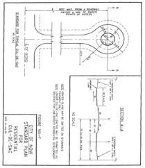
11 SITE PLAN (Full plan set available for viewing at the Community Development Department.)
12 GARFIELD ROAD NINE MILE ROAD


13 JCK GROUP, INC. WILSON ROAD GROUP, INC. DEAK PLANNING + DESIGN
14
15 PLANNING REVIEW
 To R-1 (One-Family Residential) with Planned Rezoning Overlay (PRO) PROPERTY CHARACTERISTICS Section 29")
16 PLAN REVIEW CENTER REPORT August 17, 2017 Planning Review Villa D Este JSP15-63 with Rezoning PETITIONER Cambridge Homes, Inc REVIEW TYPE Rezoning Request from RA (Residential Acreage) To R-1 (One-Family Residential) with Planned Rezoning Overlay (PRO) PROPERTY CHARACTERISTICS Section 29 and 30 Site Location West side of Beck Road, east of Napier Road and north of Nine Mile Road Parcel Id s: , and Site School District Northville Community School District Existing Zoning RA, Residential Acreage Proposed Zoning R-1, One-Family Residential Adjoining Zoning North R-1 One-Family Residential with a RUD agreement East RA, Residential Acreage West RA, Residential Acreage South RA, Residential Acreage Current Site Use Undeveloped/Single family homes North Links of Novi/vacant; Adjoining Uses East Single Family Residences West Single Family Residences South Single Family Residential/Vacant Site Size Acres (Net Site Acreage 39.18Acres) Plan Date October 09, 2017 PROJECT SUMMARY The applicant is requesting a Zoning Map amendment for a acre property on the east side of Napier Road and north side of Nine Mile Road (Section 29,30) from RA (Residential Acreage) to R-1 (One-Family Residential) utilizing the City s Planned Rezoning Overlay (PRO) option. According to the applicant, the rezoning request is necessary to allow the development of a 56-unit single-family ranch housing development (for sale). The applicant indicated that the residents will have an option to add a loft space or an attic, or an indoor pool. The concept plan indicates that this will be a gated community. All land will be considered as common element to be maintained by association. The PRO Concept Plan shows two on-site detention ponds in the northwest corner of the site and on the eastern side. One boulevard access point is proposed off of Nine Mile Road. An emergency access road is proposed off of the proposed cul-de-sac to Nine Mile Road. The development is proposed to be built in two phases.
17 JSP17-52 Villa D Este October 31, 2017 PRO Concept Plan: Planning Review Page 2 of 14 The applicant has provided a Community Impact Statement addressing the items required in the Site development manual. Staff reviewed and agrees with the findings. The applicant also provided a narrative describing in detail about the concept of the development. According to the narrative, this development is to serve the empty nesters, currently underserved in Novi, that prefer to have privacy with upscale community. The applicant believes the subject property located in low residential neighborhood and surrounded by wetlands and woodlands fits the needs. The current revised plan has included the following changes: 1. The applicant has acquired a fifth parcel about 1.5 acres in area. Fifth parcel was included in the public notices sent out. 2. The site entrance is moved further west to align with Garfield road 3. Number of units has increased from 53 to The pool and cabana area has been eliminated in response to market study results. Market study indicated that the amenities will not use as much by empty nesters. 5. The applicant proposes to add language to deed restrictions that will allow indoor pools, outdoor hot tubs, fire pits, fireplaces, pizza ovens and grills. 6. The applicant has modified the list of public benefits. 7. A comparable plan developed at R-1 density is overlain on the proposed concept plan to identify additional woodland impacts. 8. A suggestion was made to the developer to hold public open houses in order to better communicate with the residents around the project area. The applicant has hosted to open houses (one with immediate neighbors only) to spread awareness about the proposed concept. PRO OPTION The PRO option creates a floating district with a conceptual plan attached to the rezoning of a parcel. As part of the PRO, the underlying zoning is proposed to be changed (in this case from RA to R-1) and the applicant enters into a PRO agreement with the City, whereby the City and the applicant agree to tentative approval of a conceptual plan for development of the site. Following final approval of the PRO concept plan and PRO agreement, the applicant will submit for Preliminary and Final Site Plan approval under standard site plan review procedures. The PRO runs with the land, so future owners, successors, or assignees are bound by the terms of the agreement, absent modification by the City of Novi. If the development has not begun within two (2) years, the rezoning and PRO concept plan expires and the agreement becomes void. PREVIOUS MEETINGS The new rezoning category requested by the applicant is currently not supported by the Future Land Use Map. On August 23, 2017, the plan was presented before Master Planning and Zoning Committee for input. The plan received favorable recommendations from the Committee. The Committee directed the applicant to work with staff on issues such as density. On September 13, 2017, Planning Commission held a public hearing and postponed the recommendation to Council at a later time based on the following motion. a. To allow the applicant time to consider further modifications to the Concept Plan as discussed in the review letters; and b. To allow staff to advertise for another public hearing to include the fourth parcel in the public hearing notice, as this was left out from the current notice due to misrepresentation in the site plan submittal.
18 JSP17-52 Villa D Este October 31, 2017 PRO Concept Plan: Planning Review Page 3 of 14 At the time of Public hearing, Planning Commission asked the applicant to provide further information on the proposed development. Staff met with the applicant and his design team on September 20, 2017 to address the concerns raised by the Commission and the public who attended the meeting. RECOMMENDATION Staff recommends the Planning Commission consider recommending approval of the rezoning request from RA (Residential Acreage) to R-1 (One Family Residential) in order to allow the construction of a detached residential development with a maximum density of 1.43 dwelling units per acre along with the revised concept plan, and recommend approval to the City Council of the proposed PRO Concept Plan, for the following reasons: 1. The applicant has presented a reasonable alternative to the Master Plan for Land Use recommendation of 0.8 units to the acre (1.43 units to the acre proposed) for the parcel as indicated in the applicant s letter dated August 2, 2017, noting the appropriateness of a empty-nester residential development for the site given the layout of the plan, the proposed preservation of open space, the offer to provide an enhancement to public park facilities, and the provision for landscape or open space buffering on most sides of the development. 2. The proposed plan meets several objectives of the Master Plan, as noted later in this review letter, including: 1. Maintain the semi-rural character of the southwest quadrant of the City that is created by low-density residential development and undeveloped land (by protecting a majority of natural features on site and provides ample screening from Nine Mile Road. b. Provide a wide range of housing options (by being geared towards empty nesters, or those wishing to downsize from larger homes. c. Protect and maintain the City s woodlands, wetlands, water features, and open space (by proposing to donate about 18 acres (35%) of land with regulated woodlands and wetlands in the rear). 3. The City s Traffic Engineering Consultant has reviewed the Rezoning Traffic Impact Study and found that the proposed senior adult housing would produce 183 less trips per day than 40 single-family homes (as expected to be permitted under the RA zoning district, and the number of trips produced by the senior adult housing development is not expected to significantly impact Nine Mile Road. 4. Submittal of a Concept Plan and any resulting PRO Agreement, provides assurance to the Planning Commission and to the City Council of the manner in which the property will be developed, and offers benefits that would not be likely to be offered under standard development options. 5. While the applicant has addressed some of the concerns highlighted in the staff and consultant review letters, there are a number ongoing concerns by staff, primarily the density proposed with the housing pattern so closely spaced, the provision of a comparable plan (using the RA density) as requested by the Planning Commission, details of the likely woodland impacts (which the applicant wishes to address at the time of Preliminary Site Plan Review), and the deviations requested with regard to the off-site replacement, additional credits for upsizing and to waive the diversity requirement. COMMENTS 1. Density: The applicant is requesting an increase of 0.63 Dwelling Units per acre (about 78 percent more) than the maximum allowed density for RA (0.8 DUA). The maximum density proposed is 14 percent less than the maximum allowed for R-1 (1.65 DUA). Staff continues to
19 JSP17-52 Villa D Este October 31, 2017 PRO Concept Plan: Planning Review Page 4 of 14 request the applicant to strongly consider reducing the density and to provide wider setbacks between units. 2. Proposed Rezoning: The applicant is proposing ranch style units in a general condominium development. All land outside of the units is under common ownership. The concept plan proposes a development which can be reviewed against either single family development (as it proposes single family residential units) or multi-family development (as the layout that typically aligns with a multifamily development, with minimal setbacks and common areas). At the time of pre-application meeting, staff determined that R-1 would be more suitable rezoning category for the site. The extent of deviations required from R-1 standards is significantly lower than those required from RM Comparable Plan: A comparable layout plan which is developed according to the existing zoning standards. At the public hearing in September, it was the Planning Commission expressed concern that the proposed development is too dense and the proposed density could be reduced. The comparable plan would help the Commission compare and determine the additional impact, if any, to the site with regards to wetlands and woodlands, lot coverage and traffic etc. The applicant indicated that it would not be a fair comparison between the existing zoning standards and the proposed development plan as the proposed development is not a typical single family development. Please refer to Development Potential on page 7 for more information on what could be developed on this site under current zoning standards. 4. Woodland Impacts: The Planning Commission asked the applicant to provide a comparable plan to compare the impacts to woodlands and wetlands. The applicant has provided sheet WP-2. A typical residential subdivision is overlaid on top of proposed concept plan. Additional woodland impacts have been shaded. Staff agrees that a typical residential development would create additional impacts than what is being currently proposed. However it should be noted that the comparable plan appears to exceed the density allowed under existing RA zoning. Staff would not typically recommend approval of the extent of impacts proposed on the comparable plan. The applicant is encouraged to further modify the layout to minimize impacts to regulated woodlands and quality/specimen trees. Proposed impacts to individual regulated trees can be described/quantified. 5. Woodland Deviations: The applicant is requesting multiple deviations for woodland replacement plantings such as off-site replacement, additional credits for upsizing and to waive the diversity requirement. Please see Page 11 for more details. A tree survey is not included as the applicant is requesting to defer the woodland survey at the time of Preliminary site plan approval. Staff does not support the deviations at this time without a tree survey and other reasons listed in Page 11. It is recommended that the applicant provide a tree survey so that staff can make an informed recommendation or conform to the requirements at the time of Preliminary site plan. 6. Similar Dissimilar Review (Section 3.7): The applicant is seeking a deviation from similar dissimilar façade ordinance. The applicant s intent is to include a certain set of architectural standards into Master Deed. Future residents will have the ability to choose from a variety of options to customize individual facades. The applicant would like to reserve the right to regulate the façade standards within the development. Intent: The Similar / Dissimilar Ordinance requires a variation in appearance in the front elevations of adjacent homes (Sec ), and requires that homes within the larger
20 JSP17-52 Villa D Este October 31, 2017 PRO Concept Plan: Planning Review Page 5 of 14 development be consistent in design quality based on certain criteria; size (square footage), types of material, and overall architectural design character (Sec ). Staff does not support waiving the requirement altogether, but can support a slight adjustment to area within which the square footages are compared. With respect to the square footage requirement of the Similar Dissimilar Ordinance, staff can take the measurements only within the proposed development boundary. This would exclude the larger homes nearby, and thereby allow the square footage that is currently being proposed. The measurements are typically taken outside of the project if it is a Site Condominium and within the project if it is a Platted Subdivision. This would be a minor deviation from this precedent, that staff believes would be consistent with the intent of the basic Ordinance. With respect to the requirement for dissimilarity in architectural, we believe the applicant intent is to comply. 7. Amenities: Additional amenities can be added such as pocket parks, benches, and pet waste stations thought the development at different locations in addition to centralized location. 8. Public Benefits: While the proposed comfort station is an appropriate public benefit for the location, it may not be required, if City Parks, Recreation and Cultural Services Department is successful in their on-going efforts to acquire a location nearby. Staff will work with the applicant to find an alternate option to utilize the funds being donated by the applicant. COMPARISON OF ZONING DISTRICTS The following table provides a comparison of the current (RA) and proposed (R-1) zoning classifications. RA Zoning R-1 Zoning (Existing) (Proposed) Principal Permitted Uses Special Uses Land 1. One-family dwellings 2. Farms and greenhouses 3. Publicly owned and operated parks 4. Cemeteries 5. Schools 6. Home occupations 7. Accessory buildings and uses 8. Family day care homes 1. Raising of nursery plant materials 2. Dairies 3. Keeping and raising of livestock 4. All special land uses in Section Nonresidential uses of historical buildings 6. Bed and breakfasts 1. One-family detached dwellings 2. Farms and greenhouses 3. Publicly owned and operated parks, parkways and 4. outdoor recreational facilities 5. Home occupations 6. Keeping of horses and ponies 7. Family day care homes 8. Accessory buildings and uses 1. Places of worship 2. Schools 3. Utility and public service buildings (no storage 4. yards) 5. Group day care, day care centers, adult day care 6. Private noncommercial recreation areas 7. Golf courses 8. Colleges and universities 9. Private pools 10. Cemeteries 11. Mortuary establishments 12. Bed and breakfasts 13. Accessory buildings and uses Minimum Lot Size 43,560 square feet (1 acre) 21,780 sq ft (0.5 acres) Minimum Lot Width 150 feet 120 ft Building Height 2 1/2 stories -or- 35 feet 2 1/2 stories -or- 35 feet Building Front: 45 feet Front: 30 ft
 Rear: 35 ft COMPATIBILITY WITH SURROUNDING LAND USE The surrounding land uses are shown on the above chart.")
21 JSP17-52 Villa D Este October 31, 2017 PRO Concept Plan: Planning Review Page 6 of 14 Setbacks RA Zoning (Existing) Side: 20 feet (aggregate 50 feet) Rear: 50 feet R-1 Zoning (Proposed) Side: 15 ft (aggregate 40 ft) Rear: 35 ft COMPATIBILITY WITH SURROUNDING LAND USE The surrounding land uses are shown on the above chart. The compatibility of the proposed PRO concept plan with the zoning and uses on the adjacent properties should be considered by the Planning Commission in making the recommendation to City Council on the rezoning request with the PRO option. The following table summarizes the zoning and land use status for the subject property and surrounding properties. Subject Property Northern Parcels Southern Parcels Eastern Parcels Western Parcels Existing Zoning RA, Residential Acreage R-1, One-Family Residential RA, Residential Acreage RA, Residential Acreage RA, Residential Acreage Existing Land Use Single-Family Residential Links of Novi/Vacant Existing RUD agreement Vacant Single-Family Residential Single-Family Residential: Evergreen Estates Master Plan Land Use Designation Single-Family Residential at a maximum of 0.8 units/acre Single-Family Residential at a maximum of 0.8 units/acre. Existing RUD agreement limits the number of units to 439 per 324 acres Single-Family Residential at a maximum of 0.8 units/acre Single-Family Residential at a maximum of 0.8 units/acre Single-Family Residential at a maximum of 0.8 units/acre All properties immediately adjacent to the subject property are predominantly underdeveloped or vacant. The property directly north of the subject property is currently functioning as a recreational use (Golf course). The current zoning map indicates R-1 for the property on the north, but it has recorded development agreement associated with it which limits the maximum number of units to 439 that can be developed under the conditions listed in Quail Hollow RUD agreement. The development agreement also indicates that 42 percent of total site area (about 137 acres) will be preserved as permanent open space. About 73 acres will be contributed to the City. The development proposes trail system through the community. Directly to the south of the subject properties are a handful of single-family residential homes on residential lots along Nine Mile Road. All of these properties would experience traffic volumes along Nine Mile Road greater than existing (three single family houses exist on the subject property. However, the volumes are not considerably more than what would be expected with development under the current zoning.

22 JSP17-52 Villa D Este October 31, 2017 PRO Concept Plan: Planning Review Page 7 of 14 The property to the west of the subject property along Nine Mile Road is the Evergreen Estates. It is developed according to RA requirements. The other property on the west is currently a single family residence. To the east is one single family home and the ITC Corridor where the City will be constructing a regional trail to be completed by The other developments which are in the vicinity are Bella Terra, Vasilios Estates and Park Place development. Bella Terra was developed using the Residential Unit Development option, thus permanently preserving 61 percent of the total site acreage. Park Place East was developed using the Open Space Conservation option, preserving about 45 percent Open space. All the developments in the surrounding area are either developed by RA requirements or used Open Space or RUD options and preserved open spaces. The applicant was recommended to use one of these options to maintain the natural quality of the area. He indicated that RUD development would not allow him to propose empty nester development he is currently proposing. Impacts to the surrounding properties as a result of the proposal would be expected as part of the development of any residential development on the subject property and could include construction noise and additional traffic. The loss of woodland area on the property would present an aesthetic change but that would also happen with development under the current zoning. The vacant lots and the single family residences surrounding the subject property have minimum potential for a possible future condominium development as they are predominantly filled with regulated woodlands and wetlands (See Figure to the right). DEVELOPMENT POTENTIAL AND DENSITY PROPOSED Development under the current RA zoning could result in the construction of up to 30 single-family homes under the allowable density and net acreage of the site. It is not known whether the site could be developed with 30 lots that meet the dimensional requirements of the RA zoning district. Development under the master-planned density of 0.8 units to the acre (equivalent to existing RA zoning) would be up to 31 single family homes. Development under the proposed R-1 zoning without a PRO option could result in as many as 64 single family detached homes. As proposed, the development would be limited to 56 single-family detached homes. The applicant is proposing 56 units on the net acres resulting in approximately 1.43 units/acre density. As previously mentioned, the Master Plan for Land Use recommends 0.8 units per acre for the subject property and the properties surrounding it. Proposed density is most consistent with the proposed R-1 One-Family Residential District (maximum density of 1.65 units per acre). It is density is 78 percent more the Master Plan recommendation for the site The subject property is currently located in the southwest quadrant of the City which is predominantly low residential and is also master planned for low density residential. REVIEW CONCERNS Infrastructure Concerns An initial engineering review was done as part of the rezoning with PRO application to analyze the information that has been provided thus far. Water main is currently available to connect along Nine Mile Road and the applicant is connecting it through Evergreen court. The applicant is
23 JSP17-52 Villa D Este October 31, 2017 PRO Concept Plan: Planning Review Page 8 of 14 proposing to connect to the future gravity sewer main. The gravity sewer main in Nine Mile is a public project currently under design. The proposed development proposes connection to this gravity main. The City makes no guarantee that the project will be constructed prior to the construction of proposed development as plans are still subject to review and approval by all required governmental entities. Construction of this development would not be permitted to begin prior to the sewer being available for use. In the event that the City s sewer project is not available for this development, the applicant would need to submit an alternative plan for the full review process. A full scale engineering review would take place during the course of the Site Plan Review process for any development proposed on the subject property, regardless of the zoning. Traffic The City s traffic consultant has reviewed the Rezoning Traffic Impact Study. The senior adult housing under the PRO produced less trips than both the 40 single-family homes development and the 32 single-family homes development for the AM peak hour, the PM peak hour, and daily trips. It does not appear to impact Traffic patterns in the surrounding area. The applicant has aligned the proposed Villa d Este Boulevard with Garfield Road. Non-Motorized Improvements City of Novi Non-motorized plan planned for two trails abutting the subject property: ITC Regional trail Phase 1A along the eastern boundary of the subject property and (2) proposed Singh trail in the northern property. The proposed concept plan proposes a connection to the ITC trail. However, the connection ends at property line. The connection should be made all the way to the trail. Staff recommends that the applicant work with Engineering to determine suitable locations for future connections. Woodlands A Woodland Study Plan (Sheet WP-1) has been included with the Plan that indicates the approximate location of the Regulated Woodland boundary as indicated on the City s Regulated Woodland Map with respect to the proposed limits of disturbance for the development. The Woodland Study Plan notes that acres of the 51 acre development site is existing tree canopy based on the City s Regulated Woodlands Map. As such, the current Plan notes that acres of the acres (30 %) of the Regulated Woodlands located on-site will be impacted. Proposed impacts to individual trees have not been described/quantified. The Plan does not currently appear to indicate the proposed sizes and species of the proposed onsite Woodland Replacement Trees. The Plan should clearly indicate the locations, sizes, species and quantities of all woodland replacement trees to be planted. Woodland review could not complete a comprehensive review due to deficiencies in the plan. The applicant is encouraged to further modify the layout to minimize impacts to regulated woodlands and quality/specimen trees. Please refer to the woodland review letter or additional information requested. Wetlands The currently proposed wetland impacts will not likely require wetland mitigation as the City s threshold for wetland mitigation is 0.25-acre of wetland impact and the MDEQ s threshold is acre. The current plan proposes a total impact is 0.07-acre (452 cubic yards) to the wetlands and 0.45-acre of impacts to on-site 25-foot wetland/watercourse buffer area. Please refer to the wetland review letter or additional information requested. Floodplain The Plan appears to propose some impacts to the existing floodplain on site. The applicant indicated in response letter that the related permits will be applied once the Concept plan is approved. Open Space The applicant is proposing to dedicate about 18 acres of land with natural features to the City to
24 JSP17-52 Villa D Este October 31, 2017 PRO Concept Plan: Planning Review Page 9 of 14 be preserved as permanent open space. The revised concept plan eliminated all the previously proposed amenities for residents such as the pool house, lawn bowling etc. Staff recommends adding few additional amenities such as pocket parks, benches, and pet waste stations thought the development at different locations MASTER PLAN FOR LAND USE: GOALS AND OBJECTIVES 2016 Master Plan for Land Use update (adopted by Planning Commission on July 26, 2017) identifies this property and all adjacent land within the City as single family residential, with a density of 0.8 dwelling units per acre. It matches the existing zoning of the subject property. The proposed development would follow/contradict objectives of the Master Plan as listed below. Staff comments are in bold. 1. Quality and variety of housing: a. Maintain the semi-rural character of the southwest quadrant of the City that is created by low-density residential development and undeveloped land. The proposed development does propose to protect a majority of natural features on site and provides ample screening from Nine Mile Road. However, the housing pattern itself looks dense within the limits of development and does not align with semi-rural character. b. Provide residential developments that support healthy lifestyle. Ensure provision of neighborhood open space within residential developments. The proposed development includes a pool with amenities, sidewalks on both sides of the streets (for the most part), dog walk area and a lawn bowling. It also proposes a connection to proposed ITC Connector pathway. c. Provide a wide range of housing options. The proposed development is geared towards empty nesters. 2. Environmental Stewardship a. Protect and maintain the City s woodlands, wetlands, water features, and open space. The applicant proposes to donate about 18 acres (35%) of land with regulated woodlands and wetlands in the rear. MAJOR CONDITIONS OF PLANNED REZONING OVERLAY AGREEMENT The Planned Rezoning Overlay process involves a PRO concept plan and specific PRO conditions in conjunction with a rezoning request. The submittal requirements and the process are codified under the PRO ordinance (Section ). Within the process, which is completely voluntary by the applicant, the applicant and City Council can agree on a series of conditions to be included as part of the approval. The applicant is required to submit a conceptual plan and a list of terms that they are willing to include with the PRO agreement. The applicant has submitted a conceptual plan showing the general layout of the internal roads and lots, location of proposed detention ponds, location of proposed open space and preserved natural features and a general layout of landscaping throughout the development. The applicant has provided a narrative describing the proposed public benefits and community impact statement. Staff will work with the applicant to come up with appropriate conditions to be included in the agreement. Some suggestions are listed below. 1. The development will be limited to a density, to be determined at the Planning Commission meeting.
25 JSP17-52 Villa D Este October 31, 2017 PRO Concept Plan: Planning Review Page 10 of The proposed unit boundary shown on the concept plan (sheet 02) is to be considered the maximum allowable footprint. Any accessory uses such as hot tubs, patios, etc. will be provided within the footprint shown on the plan. 3. A minimum of 15 feet shall be maintained between two buildings. 4. A minimum of 30 feet is provided between the front façade and the back of the curb. 5. The applicant will work with staff to identify a proper location to connect to ITC trail, beyond the subject property line. 6. The applicant shall limit the wetland and woodland impacts to the areas and percentages indicated on the concept plan at the time of Preliminary Site Plan. ORDINANCE DEVIATIONS Section D.i.c(2) permits deviations from the strict interpretation of the Zoning Ordinance within a PRO agreement. These deviations must be accompanied by a finding by City Council that each Zoning Ordinance provision sought to be deviated would, if the deviation were not granted, prohibit an enhancement of the development that would be in the public interest, and that approving the deviation would be consistent with the Master Plan and compatible with the surrounding areas. Such deviations must be considered by City Council, who will make a finding of whether to include those deviations in a proposed PRO agreement. The proposed PRO agreement would be considered by City Council after tentative approval of the proposed concept plan and rezoning. The concept plan submitted with an application for a rezoning with a PRO is not required to contain the same level of detail as a preliminary site plan. Staff has reviewed the concept plan in as much detail as possible to determine what deviations from the Zoning Ordinance are currently shown. The applicant may choose to revise the concept plan to better comply with the standards of the Zoning Ordinance, or may proceed with the plan as submitted with the understanding that those deviations would have to be approved by City Council in a proposed PRO agreement. The following are deviations from the Zoning Ordinance and other applicable ordinances shown on the concept plan. The applicant has submitted a narrative describing the requested deviations. The applicant should consider submitting supplemental material discussing how if each deviation were not granted, [it would] prohibit an enhancement of the development that would be in the public interest, and that approving the deviation would be consistent with the Master Plan and compatible with the surrounding areas. Planning Deviations: The applicant is proposing a layout that does not meet the minimum dimensional standards for a single family development. Staff identified that deviations will be required for lot size, lot frontage, setbacks, lot coverage, but is currently unable to identify the extent of deviations due to insufficient information. The Planning Commission may choose to approve the concept plan as shown subject to following conditions: 1. The proposed unit boundary shown on the concept plan (sheet 02) is to be considered the maximum allowable footprint. Any accessory uses such as hot tubs, patios, etc. will be provided within the footprint shown on the plan. 2. A minimum of 15 feet shall be maintained between two buildings. 3. A minimum of 30 feet is provided between the front façade and the back of the curb. Landscape Deviations: In general, the landscape plan conforms to the requirements. There are a couple of deviations that staff recommends in order to protect the existing natural features. For example, a deviation to not provide street trees in front of the wetland, to not provide the required buffer screening or berms within the wetland or wetland buffer, in order to not disturb the wetland. Engineering Deviations:
26 JSP17-52 Villa D Este October 31, 2017 PRO Concept Plan: Planning Review Page 11 of 14 Absence of stub street to the property boundary at intervals not to exceed 1,300 feet along the perimeter. Not providing non-paved eyebrows. Absence of sidewalk along the portion of the south side of Villa Drive and the east side of Villa D Este Blvd. Blocks longer than 1400 feet. Traffic Deviations: The sidewalks should be located a minimum of 15 feet from the back of curb The applicant has horizontal curve radii throughout the site that fall below the minimum required horizontal curve radii. Woodland Deviations: The applicant is seeking the following deviations to the Woodlands Replacement Ordinance. Landscape Design Manual does not allow additional credits for upsizing the woodland replacement trees. Staff does not support this deviation. Tree Type Credit requested Credit allowed 6-8 Evergreens 1 Credit 0.67 credit Evergreens 2 Credits 0.67 credit 4 Deciduous Trees 2 Credits 1 credit allowed for 2.5 or more deciduous Subcanopy 1 Credit 1 credit allowed, if the replacement planting is from recommended list Allow offsite woodland replacement planting credits adjacent to Garfield Road, Nine Mile Road on ITC easements in the vicinity of the proposed project entrance and for screening on adjoining neighbor s property. Conditioned on approval by landowners. Staff believes that it is not practical to propose woodlands replacement in off-site locations as proposed. An off-site conservation easement is required for any off-site woodland replacements. Staff does not support this deviation. Due to the ITC transmission lines, poles and screening for the existing homes on Nine Mile, a deviation from the woodland replacement diversity requirements is requested to allow a higher use of evergreens relative to species of impacted trees. The current submittal did not include a tree survey. Without knowing the existing tree species or proposed tree replacement types, staff is unable to support this deviation. In addition, the landscape design manual recommends a similar proportion of woodland replacements to those removed by species. For example, if 20 percent of red maples are removed, the replacement should include a similar percentage of red maples. It is staff s understanding that there are not many existing evergreens that are being removed on site to justify the replacement evergreens proposed. Staff does not support this deviation. Façade Deviations: Façade review is not required for Concept PRO plan unless the applicant wants to demonstrate that the buildings will an enhancement, which would be unlikely to be achieved if it were not a Planned Rezoning Overlay. Applicant did not indicate any additional enhancement to the building elevations. The applicant is requesting to waive the similar dissimilar review for individual units. Staff does not support waiving the requirement altogether, but can support a slight adjustment to area within which the square footages are compared. APPLICANT BURDEN UNDER PRO ORDINANCE
27 JSP17-52 Villa D Este October 31, 2017 PRO Concept Plan: Planning Review Page 12 of 14 The Planned Rezoning Overlay ordinance requires the applicant to demonstrate that certain requirements and standards are met. The applicant should be prepared to discuss these items, especially in number 1 below, where the ordinance suggests that the enhancement under the PRO request would be unlikely to be achieved or would not be assured without utilizing the Planned Rezoning Overlay. Section D.ii states the following: 1. (Sec D.ii.a) Approval of the application shall accomplish, among other things, and as determined in the discretion of the City Council, the integration of the proposed land development project with the characteristics of the project area, and result in an enhancement of the project area as compared to the existing zoning, and such enhancement would be unlikely to be achieved or would not be assured in the absence of the use of a Planned Rezoning Overlay. 2. (Sec D.ii.b) Sufficient conditions shall be included on and in the PRO Plan and PRO Agreement on the basis of which the City Council concludes, in its discretion, that, as compared to the existing zoning and considering the site specific land use proposed by the applicant, it would be in the public interest to grant the Rezoning with Planned Rezoning Overlay; provided, in determining whether approval of a proposed application would be in the public interest, the benefits which would reasonably be expected to accrue from the proposal shall be balanced against, and be found to clearly outweigh the reasonably foreseeable detriments thereof, taking into consideration reasonably accepted planning, engineering, environmental and other principles, as presented to the City Council, following recommendation by the Planning Commission, and also taking into consideration the special knowledge and understanding of the City by the City Council and Planning Commission. PUBLIC BENEFIT UNDER PRO ORDINANCE Section D.ii states that the City Council must determine that the proposed PRO rezoning would be in the public interest and the public benefits of the proposed PRO rezoning would clearly outweigh the detriments. The applicant has offered the following items as public benefits. Staff Comments are in bold. 1. Donate approximately 18+ acres of land to Novi for existing park system. This will allow Novi to expand its parkland in this area and will connect two parcels of City parkland. This donation is conditional that Novi cannot sell the parcel, or develop the parcel, otherwise the property reverts back to original owner. Eighteen acres would count to about thirty seven percent of total gross area. City may reserve a right to make minor improvements in the area to propose a trail or accessory uses for a trail. City Council expressed interest in acquiring lands with natural features to create nature corridors. Proposed land to be dedicated abuts proposed ITC trail. This is considered a public benefit. 2. The Developer proposes to build a comfort station for ITC Trailhead subject to us understanding scope of work or contribute cash to the sanitary sewer installation costs on Nine Mile or Novi can allocate funds per its discretion. ($200,000 cap). Novi Parks has applied for a grant to acquire a property south of Nine Mile Road west of Garfield Road to build a trail head for ITC corridor. If that falls through, a comfort station at this location would be redundant. Staff will work with the applicant prior to approval of PRO agreement to identify a suitable project to allocate the $200,000 funds offered by the applicant. This is considered a public benefit. 3. Reduce cost for City of Novi to transport soils from installation of sanitary sewer on Nine Mile. Allow the city to place uncontaminated soils on property at Nine Mile and Garfield Road. It should not be discounted as we see this as a potential win/win proposition. As mentioned
28 JSP17-52 Villa D Este October 31, 2017 PRO Concept Plan: Planning Review Page 13 of 14 above, if City acquires the property on Garfield for a trailhead, it is City s intent to transport soils from the sewer installation to that property. The offered benefit would not provide any significant reduction in costs even otherwise. On the contrary, it may benefit the developer by providing soils for the proposed screening berms on the property. 4. Remove debris and shut down wood chip operation on property and increase property values around the area. There is a redevelopment potential for the property even if the property is developed according to existing zoning, but perhaps not as likely. 5. Pave part of Nine Mile from Garfield to entrance to Villa D este with chip seal and upgrade the Nine Mile and Garfield intersection. City of Novi Department of Public services does not approve chip seal pavement along Nine Mile Road. The pavement material does not withstand the wear and tear. Nine Mile road along the subject property is designated as natural beauty road by Oakland County Road Commission. The applicant should provide more information regarding the proposed upgrade to the intersection as such what it would include. 6. Increase tax base by $40,000,000. Many Novi residents have children in Northville Public schools. This project raises funding for schools and has no negative impact to the school system. Single family homes would increase tax base by $20,000,000 dollars and have an impact on school system. An increase in tax base is considered an incidental benefit. 7. Provide an outstanding development and extensive landscaping. All of our previous developments have exceeded expectations. Villa D Este will also. More detailed plans will be provided at site plan approval. Conceptual landscape plans provided appear to meet the minimum requirements of landscape ordinance. The plans do not appear to propose anything beyond the minimum requirements. Staff will be able to make a better determination at the time of Preliminary Site Plan. 8. Generate $224,000 dollars in sanitary sewer tap fees to help pay for the new sanitary sewer. Sewer tap fees is a standard requirement, cannot be perceived as a public benefit. Staff acknowledges the significant benefits 1 and 2, offered by the applicant. It is staff s opinion that benefits numbered 3, 4, 6 and 8 do not meet the intent of public benefits and should be eliminated from PRO agreement. SUMMARY OF OTHER REVIEWS a. Engineering Review ( ): Additional comments to be addressed with revised concept plan submittal. Engineering is recommending approval for reasons noted in the letter. b. Landscape Review ( ): Landscape review has identified few waivers that may be required. Refer to review letter for more comments. Landscape recommends approval. c. Wetland Review ( ): A City of Novi Wetland Non-Minor Use Permit and an authorization to encroach into 25 foot buffer setback are required for this site plan at the time of Preliminary Site Plan review. Additional comments to be addressed with revised Site Plan submittal. Wetland is recommending approval for reasons noted in the letter. d. Woodland Review ( ):: A City of Novi woodland permit is required for the proposed plan at the time of Preliminary Site Plan review. Additional comments to be addressed with revised Concept Plan submittal. Woodland is not recommending approval for reasons noted in the letter. e. Traffic Review ( ): Additional Comments to be addressed with revised concept plan submittal Traffic recommends approval. f. Facade Review: Façade review is not required for Concept PRO plan unless the applicant wants to demonstrate that the buildings will an enhancement, which would be unlikely to
29 JSP17-52 Villa D Este October 31, 2017 PRO Concept Plan: Planning Review Page 14 of 14 be achieved if it were not a Planned Rezoning Overlay. Applicant did not indicate any additional enhancement to the building elevations. g. Fire Review ( ): Additional Comments to be addressed with revised concept plan submittal. Fire recommends approval PLANNING COMMISSION MEETING Some reviews are not currently recommending approval. A Planning Commission public hearing is scheduled for November 08, 2017 meeting per applicant s request. The following are required no later than 11 am November 03, 2017: 1. A response letter to all staff and consultant review letters 2. A color rendering of the site plan (Optional) 3. Concept plan submittal in PDF format If the applicant has any questions concerning the above review or the process in general, do not hesitate to contact me at or skomaragiri@cityofnovi.org. Sri Ravali Komaragiri Planner
30 PLANNING REVIEW CHART Review Date: October 31, 2017 Review Type: Revised Concept Plan (Planner Rezoning Overlay) Project Name: JSP VILLA D ESTE Plan Date: October 09, 2017 Prepared by: Sri Komaragiri, Planner skomaragiri@cityofnovi.org; Phone: (248) Items in Bold need to be addressed by the applicant with revised submittal. Underlined items need to be addressed on the Preliminary Site Plan. Item Required Code Proposed Zoning and Use Requirements Master Plan (adopted July 26, 2017) Zoning (Effective December 25, 2013) Uses Permitted (Sec.3.1.1) Single Family, with master planned 0.8 maximum dwelling units per acre. RA: Residential Acreage district Single Family Dwellings 56 Unit single family residential development with PRO overlay; 1.42 maximum dwelling units per acre R-1 One-Family Residential District Single Family Dwellings (Ranch style Condos) with PRO Overlay Meets Code No No No Comments As discussed at the meeting, the applicant is requesting to rezone to R- 1. Phasing Is Phasing involved? Two phases Please indicate phase lines on the plan. Planned Rezoning Overlay Document Requirements Written Statement (Site Development Manual) The statement should describe the following Potential development under the proposed zoning and current zoning Identified benefit(s) of the development - Current RA Zoning: upto 31 homes (0.8 DUA) - Proposed R-1 Zoning: upto 64 homes (1.65 DUA) - Proposed Concept: 56 units (1.42 DUA) Yes Provided Yes? Please refer to comments in the review letter Conditions proposed for inclusion in the PRO Agreement (i.e., Zoning Ordinance deviations, limitation on total units, etc) Not provided Yes Please refer to comments in the review letter
31 JSP 17-52: VILLA D ESTE Page 2 of 9 PRO Concept Plan: Planning Review Summary Chart Item Required Code Proposed Rezoning Sign Location Plan (Page 23,SDM) Installed within 15 days prior to public hearing Located along all road frontages Installed Meets Code Yes Comments Public Benefits (Section D.ii) Traffic Impact Study (Site development manual) Community Impact Statement (Sec. 2.2) Usable Open Space & Amenities City Council must determine that the proposed PRO rezoning would be in the public interest and the public benefits of the proposed PRO rezoning would clearly outweigh the detriments A Traffic Impact Study as required by the City of Novi Site Plan and Development Manual. - Over 30 acres for permitted nonresidential projects - Over 10 acres in size for a special land use - All residential projects with more than 150 units - A mixed-use development, staff shall determine Usable open space is recommended for residential developments The remainder of the review is against R-1 standards Provided in an attachment Applicant submitted a Traffic Impact Study Not required, but provided per staff s request Provided required sidewalks on wither side of street. Proposed connection to ITC trail Height, bulk, density and area limitations (Sec ) Maximum Dwelling Unit Density 1.65 DUA For RA: 0.8 DUA( For net acres, upto 31units) 1.43 DUA ( 56 Units) acres of wetland Yes? Yes Yes Please revise to include that will include benefits that fit the intent of public benefits. Contact all the necessary agencies (Parks and DPS) involved to get their input on feasibility of improvements proposed as public benefits. Refer to Traffic Review. Staff agrees with the findings No Additional amenities can be added such as pocket parks, benches, and pet waste stations thought the development at different locations in addition to centralized location. No The maximum density conform to R-1 requirements Staff recommends the applicant to consider reducing the density
32 JSP 17-52: VILLA D ESTE Page 3 of 9 PRO Concept Plan: Planning Review Summary Chart Item Required Code Proposed Minimum Lot Area (Sec 3.1.2) 21,780 square feet For RA: 1 Acre (43,560 square feet) Minimum Lot 120 ft. Width (Sec 3.1.2) For RA: 150 ft. Building Setbacks (Sec 3.1.2) Front 30 ft. RA: 45ft. Side 15 ft. one side and 40 ft. total two sides RA: 20 ft. one side, 50 ft. two sides Rear 35 ft. RA: 50 ft. Maximum % of Lot Area Covered (By All Buildings) (Sec 3.1.2) Minimum Floor Area (Sec 3.1.2) Unable to determine The layout proposes single ranch style housing with common areas as opposed to site condominium with lot lines Unable to determine 30 ft. measured from back of the curb 15 ft minimum distance between buildings Unable to determine Meets Code No No No Yes No 25% Unable to determine No 1,000 Sq.ft. Information is not provided at this point No Comments Staff is unable to identify the extent of deviations sought. Council may recommend the concept plan as proposed on Planning Commission s recommendation Staff is unable to identify the extent of deviations sought. Council may recommend the concept plan as proposed on Planning Commission s recommendation Details reviewed at plot plan phase Building Height (Sec 3.1.2) 35 ft. or 2.5 stories whichever is less No elevations provided at this time. The applicant indicated in the response letter that the tentative height is 35 ft. NA Please specify to verify conformance. Building height reviewed at plot plan phase. Please mention the tentative height. Frontage on a Public Street. (Sec. 5.12) No lot or parcel of land shall be used for any purpose permitted by this Ordinance unless said lot or parcel shall front directly upon a public street, unless otherwise provided for in this Ordinance. Parking and other requirements Number of Parking Spaces Private clubs (Sec B) Two (2) for each dwelling unit All units front on a proposed road within the proposed condominium, with access to Nine Mile Road Proposed parking in the garage and in front of garage Yes Yes? The community is gated and would require City Council approval. Where are the mailboxes provided? Is parking allowed on street? Are the driveways deep
33 JSP 17-52: VILLA D ESTE Page 4 of 9 PRO Concept Plan: Planning Review Summary Chart Item Required Code Proposed Meets Code Comments enough for parking in front of garage? Barrier Free Spaces Barrier Free Code For total 1 to 25 = 1 van accessible Not applicable for single family development NA Accessory Structures Any accessory structures shall meet the requirements for section 4.19 Unable to determine No? Indicate whether dumpster, generators or rooftop equipment is provided for the poll facility. Any deviations to the possible location should be requested prior to concept plan submittal. Note to District Standards (Sec 3.6) Area - Lot width shall be Requirements measured between (Sec 3.6A & Sec. two lines where a 2.2) front setback line intersects with side setback lines. - Distance between side lot lines cannot be less than 90% between the front setback line and the main building. Additional Setbacks (Sec 3.6B) Exterior Side yard abutting Streets(Sec 3.6C) Wetland/Watercourse Setback (Sec 3.6M) Woodlands (City Code Chapter 37) Replacement of removed trees NA NA 25ft. from boundary of a wetland and 25ft. from the ordinary highwater mark of a watercourse. Unable to determine No Staff is unable to identify the extent of deviations sought. Council may recommend the concept plan as proposed on Planning Commission s recommendation Single family development. Off-street parking is provided for the accessory use to the development Side yards abutting residential districts 25ft. wetland buffer indicated. Woodland impacts proposed NA NA No No Additional information requested for on-site evaluation. Refer to wetland review for more details. Additional information requested. Refer to woodland review for more details. Woodland tree survey is recommended to be submitted prior to
34 JSP 17-52: VILLA D ESTE Page 5 of 9 PRO Concept Plan: Planning Review Summary Chart Item Required Code Proposed Subdivision Ordinance (Subdivision Ordinance Appendix C, Article IV) Blocks (Subdivision Ordinance: Sec. 4.01) Lot Depth Abutting a Secondary Thoroughfare (Subdivision Ordinance: Sec A5) - Maximum length for all blocks shall not exceed 1,400 ft. - Widths of blocks shall be determined by the conditions of the layout. Lots abutting a major or secondary thoroughfare must have a depth of at least 140 Block along Villa Drive appears to be longer than 1400 feet Nine Mile road along the subject property is considered Scenic road. Meets Code No NA Comments Concept Plan approval to identify replacement counts into PRO agreement. Revise the layout to meet the code. This could be a deviation. Depth to Width Ratio (Subdivision Ordinance: Sec A6) Arrangement (Subdivision Ordinance: Sec B) Streets (Subdivision Ordinance: Sec. 4.04) Single Family lots shall not exceed a 3:1 depth to width ratio - Every lot shall front or abut on a street. - Side lot lines shall be at right angles or radial to the street lines, or as nearly as possible thereto. Extend streets to boundary to provide access intervals not to exceed 1,300 ft. unless one of the following exists: - practical difficulties because of topographic conditions or natural features - Would create undesirable traffic patterns Unable to determine Unable to determine No No Staff is unable to identify the extent of deviations sought. Council may recommend the concept plan as proposed on Planning Commission s recommendation The subject property is surrounded by regulated wetlands on the north and west, ITC corridor on the east. NA This could be a deviation and is supported by staff. Topographic Conditions (Subdivision Ordinance Sec 4.03) A. Flood plain Compliance with applicable state laws and City Code There is an existing 100 year floodplain on the subject property. Some No Applicant is responsible for contacting the necessary agencies and
35 JSP 17-52: VILLA D ESTE Page 6 of 9 PRO Concept Plan: Planning Review Summary Chart Item Required Code Proposed B. Trees and Landscaping C. Natural Features D. Man-made Features Areas in a floodplain cannot be platted Compliance with Chapter 37 and Article 5 of City Zoning Code To be preserved Lots cannot extend into a wetland or watercourse To be built according to City standards of the lots are encroaching into the floodplains. The layout also proposes storm water detention within the floodplains Landscape Plan is not provided The site has considerable wetlands None Proposed Meets Code No Yes/ No NA Comments obtain the necessary permits for the modifying the floodplain limits Clearly indicate the floodplain limits on the layout plan. Refer to Engineering letter for more details Refer to Landscape review for requirements Refer to Wetland review letter for more comments E. Open Space Areas Any Open Space Area shall meet the following: - Require performance guarantee - Shall be brought to a suitable grade - Compliance with zoning ordinance - Except for wooded areas, all ground area should be top dressed with a minimum of 25% of red fescue and a maximum of 20% perennial rye. Landscape and grading plan is not submitted. Unable to determine No F. Non-Access Greenbelt Easements Along rear or side property lines for reverse frontage lots Not applicable NA G. Zoning Boundary Screening Sidewalks Requirements Non-Motorized Plan A non-residential development abutting a residential development would need screening - Proposed unpaved trail, west of subject property from Nine Mile Road to Ten Mile Road through undeveloped park Subject property is not abutting any nonresidential development Connections to the proposed ITC trail is proposed through the system of internal sidewalks and the proposed public NA Yes
36 JSP 17-52: VILLA D ESTE Page 7 of 9 PRO Concept Plan: Planning Review Summary Chart Item Required Code Proposed Sidewalks (Subdivision Ordinance: Sec. 4.05) Public Sidewalks (Chapter 11, Sec (b), Subdivision Ordinance: Sec. 4.05) land. - ITC Corridor, abutting the eastern boundary of subject property. Sidewalks are required on both sides of proposed drives A 6 foot sidewalk is required along Nine Mile Road sidewalk Building Code and other design standard Requirements Residential Entryway Lighting Interior Site Lighting A residential development entrance light must be provided at the entrances to the development off of Dixon Road A lighting and photometric plan is required if any interior lighting is proposed. The applicant is proposing a comfort station at the south east corner of the development to complement the ITC Trail Sidewalks are proposed on either side of the proposed private drive for the most part A 8 foot concrete sidewalk is proposed along Nine Mile Road Meets Code Comments No Revise the sidewalk to meet the 6 feet width No This could be a deviation The applicant indicated that he is working with the neighboring residents to extend the sidewalk between the eastern and western legs of the subject property None indicated No Please contact Darcy Rechtein at for further details. Provide details of the proposed lighting None proposed at the moment. Yes? Building Code Building exits must be connected to sidewalk system or parking lot. Not Applicable. NA Design and Construction Standards Manual (DSM) General layout and dimension of proposed physical improvements Land description, Sidwell number (metes and bounds for acreage parcel, lot number(s), Liber, and page for subdivisions). Location of all existing and proposed buildings, proposed building heights, building layouts, (floor area in square feet), location of proposed parking and parking Not provided. No Provide land description. Some dimensions are missing. No Please refer to Traffic review comments for additional details.
37 JSP 17-52: VILLA D ESTE Page 8 of 9 PRO Concept Plan: Planning Review Summary Chart Item Required Code Proposed Economic Impact Information Legal Requirements Development and Street Names Property Split or Combination Development/ Business Sign Master Deed/Covenants and Restrictions Conservation easements PRO Agreement (Sec D(3) layout, streets and drives, and indicate square footage of pavement area (indicate public or private). - Total cost of the proposed building & site improvements - Home size & expected sales price of new homes Development and street names must be approved by the Street Naming Committee before Preliminary Site Plan approval Property combination or split shall be reviewed and approved by the Community Development Department. Sign permit applications that relate to construction of a new building or an addition to an existing building may submitted, reviewed, and approved as part of a site plan application. Refer to Planning review for more details Applicant is required to submit this information for review with the Final Site Plan submittal Conservation easements may be required for wetland and buffer impacts A PRO Agreement shall be prepared by the City Attorney and the applicant (or designee) and approved by the Project name and street name have been approved The subject property is proposing a combination of five lots. Signage is not indicated Not applicable at this moment Not applicable at this moment. They will be required at the time of Preliminary Site Plan Not applicable at this moment Meets Code Yes Yes Yes/ No NA NA NA Comments The applicant must create this parcel prior to Stamping Set approval. Plans will not be stamped until the parcel is created. For sign permit information contact Ordinance at The following documents will be required during Site Plan review process after the Concept PRO approval PRO Agreement shall be approved by the City Council after the Concept Plan is tentatively approved
38 JSP 17-52: VILLA D ESTE Page 9 of 9 PRO Concept Plan: Planning Review Summary Chart Item Required Code Proposed NOTES: City Council, and which shall incorporate the PRO Plan and set forth the PRO Conditions and conditions imposed Meets Code Comments 1. This table is a working summary chart and not intended to substitute for any Ordinance or City of Novi requirements or standards. 2. The section of the applicable ordinance or standard is indicated in parenthesis. Please refer to those sections in Article 3, 4 and 5 of the zoning ordinance for further details. 3. Please include a written response to any points requiring clarification or for any corresponding site plan modifications to the City of Novi Planning Department with future submittals.
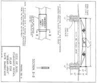
39 ENGINEERING REVIEW

40 PLAN REVIEW CENTER REPORT October 31, 2017 Engineering Review Villa d Este JSP Applicant Robert Lamp Trust Review Type PRO revised Concept Plan Property Characteristics Site Location: North of Nine Mile Road, east of Garfield Road Site Size: acres Plan Date: 10/09/2017 Design Engineer: Sieber Keast Project Summary A PRO plan for residential development north of Nine Mile Road and east of Garfield Road. Water service would be provided by an 8-inch extension from the existing 12-inch water main along the north side of 9 Mile Rd., with two connections to create a looped system. Sanitary sewer service would be provided by connection to the proposed gravity main along the north side of Nine Mile Road. Storm water would be collected by a single storm sewer collection system and detained on site in proposed detention basins. Recommendation: The Concept Plan and Concept Storm Water Management Plan can be recommended for approval.
41 Engineering Review of PRO Concept Plan October 31, 2017 Villa d Este JSP Page 2 of 4 Comments: The Concept plan meets the general requirements of Chapter 11, the Storm Water Management Ordinance and the Engineering Design Manual with the following items to be addressed in Preliminary and Final Site Plan submittals: General 1. A stub street to the property boundary at intervals not to exceed 1,300 feet along the perimeter is required by ordinance. A request for deviation from Appendix C Section 4.04(A)(1) of the Novi City Code can be requested. City staff supports this request. 2. A right-of-way permit will be required from the City of Novi. 3. The master planned right-of-way for Nine Mile Road is 43 half right-of-way. Dedication of the master-planned right-of-way should be part of this development. 4. Provide a minimum of two ties to established section or quarter section corners. 5. Provide a construction materials table on the Utility Plan listing the quantity and material type for each utility (water, sanitary and storm) being proposed. 6. Provide a utility crossing table indicating that at least 18-inch vertical clearance will be provided, or that additional bedding measures will be utilized at points of conflict where adequate clearance cannot be maintained. 7. Soil borings shall be provided for a preliminary review of the constructability of the proposed development (roads, basin, etc.). Borings identifying soil types, and groundwater elevation should be provided at the time of Preliminary Site plan. 8. A letter from either the applicant or the applicant s engineer must be submitted with the Preliminary Site Plan submittal highlighting the changes made to the plans addressing each of the comments in this review. Utilities 9. The gravity sewer main in Nine Mile is a public project currently under design. The proposed development proposes connection to this sanitary sewer. The City s project is currently under design and the City makes no guarantee that the project will be constructed as plans are still subject to review and approval by all required governmental entities. Construction of this development would not be permitted to begin prior to the sewer being available for use. In the event that the City s sewer project is not available for this development, the applicant would need to submit an alternative plan for the full review process.
42 Engineering Review of PRO Concept Plan October 31, 2017 Villa d Este JSP Page 3 of 4 Paving & Grading 10. The right-of-way sidewalk shall continue through the drive approach. If like materials are used for each, the sidewalk shall be striped through the approach. The sidewalk shall be increased to 6-inches thick along the crossing or match the proposed cross-section if the approach is concrete. The thickness of the sidewalk shall be increased to 6 inches across the drive approach. Provide additional spot grades as necessary to verify the maximum 2-percent cross-slope is maintained along the walk. 11. Provide top of curb/walk and pavement/gutter grades to indicate height of curb. 12. Within the development, sidewalks are required on both sides of the street. Absence of sidewalk along a portion of Villa Drive requires a variance, with payment into the City s sidewalk fund for the cost of the sidewalk not constructed. The request for lack of sidewalk along the south side of Villa Drive where there are no proposed residences can be supported, but sidewalk should be provided along both sides of Villa d Este Boulevard. 13. A variance from Section (8) should be requested for non-paved eyebrows. Staff will support this request. 14. Per Section (c), a statement is required on any plan containing a private street with the following language: "City of Novi has no responsibility to improve or maintain the private streets contained within or private streets providing access to the property described in this plan. Storm Water Management Plan 15. Runoff in all areas of development must be pretreated before discharge to the wetlands. Capture the storm water in all developed areas in the on-site storm water collection and detention basin systems; or provide rain gardens as the pretreatment mechanism. 16. A 25-foot vegetated buffer shall be provided around the full perimeter of each storm water basin. This buffer cannot encroach onto adjacent lots, and should not be placed immediately against adjacent structures. Provide a boundary of shrubbery or other maintainable landscape features between any structures and edge of the non-mowable basin buffer area. Flood Plain 17. Application for a City floodplain permit shall be submitted as soon as possible to begin the review process. The City s floodplain consultant will review the submittal and provide initial comments regarding the review process. An MDEQ floodplain use permit may also be required prior to site plan approval.
43 Engineering Review of PRO Concept Plan October 31, 2017 Villa d Este JSP Page 4 of 4 Off-Site Easements 18. Any off-site easements or agreements must be executed prior to final approval of the plans. Drafts shall be submitted at the time of the Preliminary Site Plan submittal. No off-site easements are anticipated at this time. Please contact Darcy Rechtien at (248) with any questions. Darcy N. Rechtien, P.E.
44 LANDSCAPE REVIEW
45 PLAN REVIEW CENTER REPORT October 12, 2017 Revised PRO Concept Site Plan Villa d Este Review Type Job # Revised PRO Concept Plan Landscape Review JSP Property Characteristics: Site Location: North side of 9 Mile Road, near Garfield Site Zoning: R-A Proposed R-1 with PRO Adjacent Zoning: North: R-A and R-1, East: R-A and ITC Corridor, South: R-A, West, R-A Plan Date: 10/9/2017 Recommendation: This concept is recommended for approval. Several landscape deviations are required to implement the concept as is proposed, but overall, the project conforms to most elements of the landscape ordinance. Deviations: 1. The required berm is not proposed along the western section of the project s Nine Mile Road frontage. 2. The require berm is not proposed west of the entrance, in the eastern section of the project s Nine Mile Road frontage. 3. A tree survey is not provided, so removals and required woodland replacements cannot be determined. Because of this deficiency, the applicant must provide a tree survey and conform to all of the rules of Section 37 (Woodlands Protection) and the Landscape Design Manual regarding woodland replacements once the extent of removals can be determined. 4. No plant list is provided to verify required diversity or whether any prohibited species are included. As a result, it is assumed that the applicant will comply with all landscape standards regarding tree sizes, species and diversity. Ordinance Considerations: This project was reviewed for conformance with Chapter 37: Woodland Protection, Zoning Article 5.5 Landscape Standards, the Landscape Design Manual and any other applicable provisions of the Zoning Ordinance. Items in bold below and on the accompanying Landscape Chart must be addressed and incorporated as part of the Preliminary Site Plan submittal. Underlined items must be addressed and incorporated as part of the Final Site Plan submittal. Please follow guidelines of the Zoning Ordinance and Landscape Design Guidelines. This review is a summary and not intended to substitute for any Ordinance. Existing Soils (Preliminary Site Plan checklist #10, #17) Provided Existing and proposed overhead and underground utilities, including hydrants.(ldm 2.e.(4)) Provided
46 Revised PRO Concept Landscape Plan October 12, 2017 JSP : VILLA D ESTE Page 2 of 3 Existing Trees (Sec 37 Woodland Protection, Preliminary Site Plan checklist #17 and LDM 2.3 (2)) 1. Woodland line per Regulated Woodlands map is shown, but a tree survey is not provided. 2. Please provide a current tree survey for all areas within 50 feet of development area. 3. Based on survey, please provide woodland replacement calculations. Proposed topography. 2 contour minimum (LDM 2.e.(1)) Proposed contours are provided on Landscape Plans and on engineering sheets. Snow Deposit (LDM.2.q.) Provided. Street Tree Requirements (Zoning Sec E.i.c and LDM 1.d.) 9 Mile Road lf frontage, less the ordinance allowances for access ways/clear vision zone (total of 140 ), less the 85 to be donated for the trail parking lot = 970 lf. 28 deciduous canopy trees are required, 30 are provided. 2. If the applicant wishes to request a landscape waiver/deviation to not provide street trees in front of the wetland in order to not disturb the wetland or wetland buffer, this would be supported by staff. Internal streets 1. Since individual units are not provided, the requirement is based on units. Based on 56 units, 56 trees are required. 74 trees are provided in front of units. 2. Cul-de-sac islands and boulevard island trees are not counted toward required street trees. This is correct. 3. Where the area between the curb and sidewalk is only 5 feet, please use deciduous subcanopy trees as street trees. Adjacent to Public Rights-of-Way Berm (Wall) & Buffer (Zoning Sec B.ii and iii) lf frontage, less the ordinance allowances for access ways (total of 75 ), less the 85 to be donated for the trail parking lot = 1035 lf. 2. Large evergreens or canopy trees: 1 tree per 40 lf = 26 trees required, 26 provided. 3. Subcanopy trees required: 1 tree per 25 lf = 41 trees required, 42 provided. 4. Berms not provided in entire western frontage, and in area immediately west of entrance. 5. A landscape deviation is required for the shortfalls in buffers provided. 6. If the applicant wishes to request a waiver/deviation for not providing the required buffer screening or berms within the wetland or wetland buffer, in order to not disturb the wetland, this would be supported by staff. Corner Clearance (Zoning Sec 5.9) Provided. Parking Lot Landscaping/Perimeter Trees (Zoning Sec C.) 1. Perimeter trees are required at the rate of 1/35 lf. 10 trees are required for the perimeter trees around the 3 bays, 16 are provided. 2. I accidentally gave the wrong requirement in the last review. The applicant can reduce the total number of trees provided around the parking bays to just 10. Please put one perimeter tree on each end of the bays. Transformer/Utility Box Screening (Zoning Sec D.) When utility box locations are provided, required screening should be added to plan and plant list.
47 Revised PRO Concept Landscape Plan October 12, 2017 JSP : VILLA D ESTE Page 3 of 3 Storm Basin Landscape (Zoning Sec E.iv and LDM 1.d.(3) 1. Requirement for 70% of pond rim to be landscaped with large native shrubs appears to be satisfied. 2. The detention pond trees shown are not required, and can t replace the required shrubs. They can count as woodland replacement trees. Plant List (LDM 2.h. and t.) Not provided, but not required for a concept plan unless species that don t conform to the woodland replacement chart or prohibited species are proposed. Planting Notations and Details (LDM) Provided Irrigation(LDM 1.a.(1)(e) and 2.s) Irrigation plan for landscaped areas or an alternative plan for ensuring that plants get the water required for establishment and long-term survival is required for Final Site Plans. If the applicant has any questions concerning the above review or the process in general, do not hesitate to contact me at or rmeader@cityofnovi.org. Rick Meader Landscape Architect
48 LANDSCAPE REVIEW SUMMARY CHART Revised PRO Concept Plan Location: Nine Mile at Garfield, north side. Review Date: October 12, 2017 Project Name: JSP : VILLA D ESTE Plan Date: October 9, 2017 Prepared by: Rick Meader, Landscape Architect rmeader@cityofnovi.org; Phone: (248) Items in Bold need to be addressed by the applicant before approval of the Preliminary Site Plan. Underlined items need to be addressed for Final Site Plan. LANDSCAPE DEVIATIONS 1. No tree survey, replacement calculations or replacement species are provided. Since this is the case, there is no assumption that the replacements are sufficient, or that there any deviations for species or sizes of replacements approved. They will need to meet current code standards. 2. No berm is provided along the entire 570 lf of western frontage. The required berm is an undulating berm with a minimum height of 4 feet and crest 4 feet wide. 3. No berm is provided west of the entrance. The same requirements for the berm discussed above apply here. 4. No plant list is provided to verify required diversity or whether any prohibited species are included. As a result, it is assumed that the applicant will comply with all landscape standards regarding tree sizes, species and diversity. Item Required Proposed Landscape Plan Requirements (LDM (2) Landscape Plan (Zoning Sec 5.5.2, LDM 2.e.) Project Information (LDM 2.d.) Owner/Developer Contact Information (LDM 2.a.) Landscape Architect contact information (LDM 2.b.) New commercial or residential developments Addition to existing building greater than 25% increase in overall footage or 400 SF whichever is less. 1 =20 minimum with proper North. Variations from this scale can be approved by LA Consistent with plans throughout set Yes Meets Code Yes Name and Address Yes Yes Name, address and telephone number of the owner and developer or association Name, Address and telephone number of RLA/LLA Yes Yes Yes Yes Comments Overall plan: 1 =50 Detail: 1 = 20
49 Revised PRO Concept Plan Review Page 2 of 9 Landscape Review Summary Chart JSP17 52: VILLA D ESTE October 12, 2017 Item Required Proposed Sealed by LA. (LDM 2.g.) Miss Dig Note (800) (LDM.3.a.(8)) Zoning (LDM 2.f.) Survey information (LDM 2.c.) Existing plant material Existing woodlands or wetlands (LDM 2.e.(2)) Soil types (LDM.2.r.) Existing and proposed improvements (LDM 2.e.(4)) Existing and proposed utilities (LDM 2.e.(4)) Proposed grading. 2 contour minimum (LDM 2.e.(1)) Snow deposit (LDM.2.q.) LANDSCAPING REQUIREMENTS Requires original signature Yes Meets Code Yes Show on all plan sheets No No Include all adjacent zoning Legal description or boundary line survey Existing topography Show location type and size. Label to be saved or removed. Plan shall state if none exists. As determined by Soils survey of Oakland county Show types, boundaries Existing and proposed buildings, easements, parking spaces, vehicular use areas, and R.O.W Overhead and underground utilities, including hydrants Provide proposed contours at 2 interval Show snow deposit areas on plan Site: R-A Proposed R-1 with PRO North: R-A and R-1, East: R-A and ITC corridor, South: R-A, West: R-A Yes No Yes Yes No Comments Yes Yes Sheet 3 Yes Yes Yes No Yes Yes Yes No Needed for Final Site Plans. Please add to all landscape plan sheets. On cover sheet Description on cover sheet. 1. Tree survey is required. 2. Please add designations of trees to be removed on plans (eg X on trees to be removed). 3. Please add woodland replacement calculations. Please clearly show all overhead utility lines on landscape plans. 1. Proposed berm contours shown. 2. Please make berm grading consistent between sheets. It appears that the berm contours on Sheet 3 are different from those on the Landscape plans. Please show areas for snow deposits.
50 Revised PRO Concept Plan Review Page 3 of 9 Landscape Review Summary Chart JSP17 52: VILLA D ESTE October 12, 2017 Item Required Proposed Parking Area Landscape Requirements LDM 1.c. & Calculations (LDM 2.o.) General requirements (LDM 1.c) Name, type and number of ground cover (LDM 1.c.(5)) General (Zoning Sec C.ii) Parking lot Islands (a, b. i) Curbs and Parking stall reduction (c) Contiguous space limit (i) Parking Lot perimeter trees Plantings around Fire Hydrant (d) Landscaped area (g) Clear Zones (LDM 2.3.(5)) Clear sight distance within parking islands No evergreen trees As proposed on planting islands A minimum of 200 SF to qualify 200 sf per tree planted in an island 6 curbs Islands minimum width 10 BOC to BOC Parking stall can be reduced to 17 and the curb to 4 adjacent to a sidewalk of minimum 7 ft. Maximum of 15 contiguous spaces 1 per 35 lf 352/35 = 10 trees No plantings with matured height greater than 12 within 10 ft. of fire hydrants Areas not dedicated to parking use or driveways exceeding 100 sq. ft. shall be landscaped 25 ft corner clearance required. Refer to Zoning Section Berms, Walls and ROW Planting Requirements NA NA NA NA Maximum bay is 7 spaces Meets Code Yes 16 trees Yes Some trees may be close to hydrants, manholes can t tell at present. NA No Comments Fewer trees can be provided if desired. Keep all trees and large shrubs at least 10 away from hydrants, manholes. Clear zones are provided. Berms All berms shall have a maximum slope of 33%. Gradual slopes are encouraged. Show 1ft. contours Berm should be located on lot line except in conflict with utilities. Berms should be constructed of loam with 6 top layer of topsoil. Residential Adjacent to Non-residential (Zoning Sec A and LDM 1.a) Berm requirements Adjacent Zoning is RA NA (Zoning Sec 5.5.A) and R1 Planting requirements LDM Novi Street Tree List NA (LDM 1.a.) Adjacent to Public Rights-of-Way (Zoning Sec A and LDM 1.b)
51 Revised PRO Concept Plan Review Page 4 of 9 Landscape Review Summary Chart JSP17 52: VILLA D ESTE October 12, 2017 Item Required Proposed Cross-Section of Berms (Zoning Sec B and LDM 2.j) Slope, height and width (Zoning Sec A.v) Label contour lines Maximum 33% slope Constructed of loam 6 top layer of topsoil Type of Ground Cover Overhead utility lines and 15 ft. setback from Setbacks from Utilities edge of utility or 20 ft. setback from closest pole Walls (LDM 2.k & Zoning Sec vi) Material, height and type of construction footing Freestanding walls should have brick or stone exterior with masonry or concrete interior Yes Meets Code No Yes Yes Lawn No None proposed Walls greater than 3 ½ ft. should be NA designed and sealed by an Engineer ROW Landscape Screening Requirements(Sec B. ii) Greenbelt width 34 ft. 54 min. Yes (2)(3) (5) Min. berm crest width 4 ft. 4 Yes/No No Comments Please provide a typical berm cross section detail. Please show any overhead utilities existing or proposed 1. The required berm is provided east of the entrance. 2. A berm is not provided west of the entrance. As much berm as possible should be provided unless it is not being provided due to the preservation of existing vegetation that is valuable and/or because of the ditch. A PRO deviation or a landscape waiver is required for this. Please provide justification. 3. No berm is provided on the western 570 lf frontage. 240 feet of this is wetland so the deviation to not
52 Revised PRO Concept Plan Review Page 5 of 9 Landscape Review Summary Chart JSP17 52: VILLA D ESTE October 12, 2017 Item Required Proposed Meets Code Comments provide a berm in this area is supported by staff but a berm should be provided along the rest of the frontage. If the berm is not provided where possible, a PRO deviation or landscape waiver is required. Minimum berm height (9) 4 ft. 4 Yes/No See above 3 wall (4) (7) NA No Canopy deciduous or large evergreen trees Notes (1) (10) LDM1.d.(1)(b) Sub-canopy deciduous trees Notes (2)(10) Street Trees (LDM 1.d.(1) and Novi Street Tree List)) Island & Boulevard Planting (Zoning Sec & LDM 1.d.(1)(e)) 1 tree per 40 l.f.; 9 Mile Road ( )/40 = 26 trees Possible waiver for wetland/buffer: 180/40 = 5 trees 1 tree per 25 l.f.; 9 Mile Road ( )/25 = 41 trees Possible waiver for wetland/buffer: 180/25 = 7 trees 9 Mile Road: 1 tree per 35 lf ( )/35 = 28 trees Internal lots 1 tree per unit since individual lots are not provided. 56 units. Must be landscaped & irrigated Mix of canopy/subcanopy trees, shrubs, groundcovers, etc. No plant materials between heights of Mile Road: 26 trees Yes 42 trees Yes 9 Mile Road: 30 trees Lots: 74 trees Trees shown in all islands, additional plantings in entry island. Yes 1. Calculations and required trees are provided. 2. Landscape waiver or deviation can be sought for 180 lf of wetland and wetland buffer along right-of-way where area would be negatively impacted by grading/planting and where existing screening is sufficient. This would be supported by staff. See above regarding possible waiver/ deviation. 1. See above. 2. Please use deciduous subcanopy trees for the street trees planted in the 5 gap between the curb and the sidewalk. A mix of canopy and subcanopy trees, shrubs, groundcovers etc. is provided.
53 Revised PRO Concept Plan Review Page 6 of 9 Landscape Review Summary Chart JSP17 52: VILLA D ESTE October 12, 2017 Item Required Proposed feet as measured from street grade A minimum of 2ft. separation between box and the plants Transformers/Utility Ground cover below boxes 4 is allowed up to NA (LDM 1.e from 1 pad. through 5) No plant materials within 8 ft. from the doors Detention/Retention Basin Requirements (Sec E.iv) Planting requirements (Sec E.iv) Clusters shall cover 70-75% of the basin rim area 10 to 14 tall grass along sides of basin Refer to wetland for basin mix Only trees are shown on plan. Woodland Replacements (Chapter 37 Woodlands Protection) Woodland Replacement Calculations Required/Provided Woodland Replacement Trees Proposed Show calculations based on existing tree chart. Indicate boundary of regulated woodland on plan Show clearly on plan and plant list which trees are proposed as woodland replacement trees Reforestation credit table breakdown, if applicable LANDSCAPING NOTES, DETAILS AND GENERAL REQUIREMENTS Landscape Notes Utilize City of Novi Standard Notes Installation date (LDM 2.l. & Zoning Sec B) Maintenance & Statement of intent (LDM 2.m & Zoning Sec 5.5.6) Provide intended date Include statement of intent to install and guarantee all materials for 2 years. Extent of regulated woodland boundaries is indicated in plans. Some replacement trees are shown A mix of evergreen and deciduous replacement trees are indicated no species given. Between Mar 15 Nov 15 Yes Meets Code No No No Yes Yes Comments When the locations of transformer/utility boxes are determined, add landscaping per city requirements. 1. Proposed shrubs provide required coverage. 2. Detention pond trees are not required and can count toward replacements if desired. 1. Please provide current tree survey. 2. Please provide woodland replacement calculations 3. Provided woodland replacement trees should be from Woodland Replacement Chart. Provided woodland replacement trees should be from Woodland Replacement Chart.
54 Revised PRO Concept Plan Review Page 7 of 9 Landscape Review Summary Chart JSP17 52: VILLA D ESTE October 12, 2017 Item Required Proposed Plant source (LDM 2.n & LDM 3.a.(2)) Irrigation plan (LDM 2.s.) Include a minimum one cultivation in June, July and August for the 2-year warranty period. Shall be northern nursery grown, No.1 grade A method for ensuring that plantings receive sufficient watering for establishment and longterm survival must be provided. Yes No Meets Code Other information Required by Planning (LDM 2.u) Commission NA Establishment period (Zoning Sec B) 2 yr. Guarantee Yes Yes Approval of substitutions. (Zoning Sec E) City must approve any substitutions in writing prior to installation. Yes Yes Plant List (LDM 2.h.) Include all cost estimates Quantities and sizes Root type Botanical and common names Breakdown of genus/species diversity (LDM 1.d.(1).d. Type and amount of lawn Cost estimate (LDM 2.t) Refer to LDM suggested plant list For all new plantings, mulch and sod as listed on the plan No plant list Planting Details/Info (LDM 2.i) Utilize City of Novi Standard Details Canopy Deciduous Tree Refer to LDM for detail drawings No No Yes No No Comments Evergreen Tree Yes Yes See above Yes Yes 1. If an irrigation system is to be provided, the plan for that system should be provided with Final Site Plans. 2. If a system is not provided, notes regarding how plantings will receive sufficient water for establishment and survival must be part of the Final Site Plans. Please be sure that diversity of plantings conforms with standard listed in Design Manual Need for Final Site Plan Need for Final Site Plan Please add callout stating that root ball dirt should be removed from root flare.
55 Revised PRO Concept Plan Review Page 8 of 9 Landscape Review Summary Chart JSP17 52: VILLA D ESTE October 12, 2017 Item Required Proposed Meets Code Comments Multi-stem Tree Yes Yes See above Shrub Yes Yes Perennial/ Ground Cover Tree stakes and guys. (Wood stakes, fabric guys) Tree protection fencing Located at Critical Root Zone (1 outside of dripline) Other Plant Material Requirements (LDM 3) General Conditions (LDM 3.a) Plant Materials & Existing Plant Material (LDM 3.b) Landscape tree credit (LDM3.b.(d)) Plant Sizes for ROW, Woodland replacement and others (LDM 3.c) Plant size credit (LDM3.c.(2)) Prohibited plants (LDM 3.d) Recommended trees for planting under overhead utilities (LDM 3.e) Collected or Transplanted trees (LDM 3.f) Nonliving Durable Material: Mulch (LDM 4) Plant materials shall not be planted within 4 ft. of property line Clearly show trees to be removed and trees to be saved. Substitutions to landscape standards for preserved canopy trees outside woodlands/wetlands should be approved by LA. Refer to Landscape tree Credit Chart in LDM Refer to Chapter 37, LDM for more details NA No plants on City Invasive Species List Label the distance from the overhead utilities Trees shall be mulched to 4 depth and shrubs, groundcovers to 3 depth Specify natural color, finely shredded hardwood bark mulch. Include in cost Yes Yes No Yes No None Yes No plant list included NA Yes Yes Yes No Yes No No TBD Yes Please provide detail and tree fencing locations on demolition and grading plans. Please add note near property lines. Include sizes on plant list. Please dimension distance from proposed trees close to overhead lines if any exist. Please specify compost instead of peat mulch in your planting mix. Canadian wetlands are harvested for the peat, causing environmental damage.
56 Revised PRO Concept Plan Review Page 9 of 9 Landscape Review Summary Chart JSP17 52: VILLA D ESTE October 12, 2017 Item Required Proposed NOTES: estimate. Refer to section for additional information Meets Code Comments 1. This table is a working summary chart and not intended to substitute for any Ordinance or City of Novi requirements or standards. 2. The section of the applicable ordinance or standard is indicated in parenthesis. For the landscape requirements, please see the Zoning Ordinance landscape section 5.5 and the Landscape Design Manual for the appropriate items under the applicable zoning classification. 3. Please include a written response to any points requiring clarification or for any corresponding site plan modifications to the City of Novi Planning Department with future submittals.
57 WETLAND REVIEW
58 ECT Project No October 26, 2017 Ms. Barbara McBeth, AICP City Planner Community Development Department City of Novi W. Ten Mile Road Novi, Michigan Re: Villa d Este (JSP ) Wetland Review of the Revised PRO Concept Plan (PSP ) Dear Ms. McBeth: The Revised PRO Concept Plan (PSP ) for the proposed Villa d Este project prepared by Seiber, Keast Engineering, L.L.C. dated October 9, 2017 and stamped Received by the City of Novi Community Development Department on October 9, 2017 (Plan) was transmitted to Environmental Consulting & Technology, Inc. (ECT) for our information only. The wetland comments from our previous Wetland Review of the Concept Plan (PRO) (PSP1-0120) letter are still applicable and contained below. The Plan was reviewed for conformance with the City of Novi Wetland and Watercourse Protection Ordinance and the natural features setback provisions in the Zoning Ordinance. ECT currently recommends approval of the Revised PRO Concept for Wetlands. ECT recommends that the Applicant address the items noted in the Wetland Comments section of this letter in subsequent site plan submittals. The following wetland related items are required for this project: Item Wetland Permit (specify Non- Minor or Minor) Wetland Mitigation Wetland Buffer Authorization MDEQ Permit Wetland Conservation Easement Required/Not Required/Not Applicable Required (Non-Minor) Not Required (Impacts currently 0.07-acre < 0.25-acre wetland mitigation threshold) Required To Be Determined. It is the applicant s responsibility to contact the MDEQ in order to determine the need for a wetland use permit. Required 2200 Commonwealth Blvd., Suite 300 Ann Arbor, MI The proposed development is located north of the intersection of Nine Mile Road and Garfield Road (i.e., north of Nine Mile Road between Napier Road and North Beck Road, Section 29 & 30. The Plan proposes the construction of fifty-six (56) single family detached ranch and story-and-a-half residential condo units, associated roads and utilities as well as several storm water detention basins. This is up from fifty-three proposed units on the previous concept plan. The proposed project site contains a significant amount of (734) FAX (734) An Equal Opportunity/Affirmative Action Employer
59 Villa d Este (JSP ) Wetland Review of the Revised PRO Concept Plan (PSP ) October 26, 2017 Page 2 of 9 City-Regulated Woodland area as well as a significant amount of on-site City-Regulated wetlands and a tributary to the Novi-Lyon Drain (see Figure 1). Wetland Evaluation/Wetland Impact Review ECT's in-office review of available materials included the City of Novi Regulated Wetland and Watercourse map, USGS topographic quadrangle map, NRCS soils map, USFWS National Wetland Inventory map, and historical aerial photographs. The site includes areas indicated as City-regulated wetland on the official City of Novi Regulated Wetland and Watercourse Map (see Figure 1). ECT recommends that we conduct a wetland and woodland field evaluation at the time of Preliminary Site Plan submittal in order to verify the existing on-site wetland boundaries and woodland information (tree sizes, species, conditions, etc.). The Plan notes that the onsite wetlands were flagged by Wilson Road Group, Inc. and indicates numerous areas of existing wetlands on the site. These wetland areas are generally located along the northern and western portions of the project site. Portions of these wetland areas appear to be included on the City of Novi Regulated Wetlands and Watercourse Map (attached). It should be noted that that the Plan does not appear to label the existing wetlands (i.e., Wetland A, B, etc.) or provide the acreages of the individual areas of onsite wetlands. Please label the wetlands and the associated on-site areas on the Plan. Wetland flag numbers should also be included on the Plan. Reviews of previous proposed development plans for these parcels have indicated eleven (11) existing wetlands on the site. All of these wetlands are regulated by the City of Novi and several are also likely regulated by the Michigan Department of Environmental Quality (MDEQ). The DEQ must determine the following before a permit can be issued: The permit would be in the public interest. The permit would be otherwise lawful. The permit is necessary to realize the benefits from the activity. No unacceptable disruption to aquatic resources would occur. The proposed activity is wetland dependent or no feasible and prudent alternatives exist. As noted above, several areas of wetland have been confirmed on the subject property by the applicant s wetland consultant. Currently, the Plan indicates two (2) direct impacts to on-site wetlands. It should be noted that that the Plan does not appear to label the existing wetlands or provide the acreages of the individual areas of on-site wetlands. The Plan does quantify the areas of the proposed wetland impacts. The total amount of direct (i.e., fill or excavation) impact to on-site wetlands is 0.07-acre. This is the same total quantity of wetland impact proposed on the previous concept plan. An area of wetland impact previously proposed has been removed from the Plan. This impact was in the northern section of the site located between Buildings 29 and 30 (formerly Lots 26 and 27). This wetland impact was noted as acre. This wetland impact was for the purpose of proposed grading between these two lots and for the construction of Villa Drive. It appears as if a proposed retaining wall has negated the need for a wetland fill in this location. The current impacts to Wetlands C and M are for the purpose of constructing a wetland/drain crossing for Villa Drive in two (2) locations as shown on the Plan. The following table summarizes the proposed wetland impacts as listed on the Overall Plan (Sheet 2):
60 Villa d Este (JSP ) Wetland Review of the Revised PRO Concept Plan (PSP ) October 26, 2017 Page 3 of 9 Table 1. Proposed Wetland Impacts Wetland Impact Area City Regulated? MDEQ Regulated? Impact Area (acre) Estimated Impact Volume (cubic yards) M Yes City Regulated /Essential Likely 0.04 Not Indicated C Yes City Regulated /Essential Likely 0.03 Not Indicated TOTAL Not Indicated The Plan also includes the construction of several storm water management basins (Basins A and B) located adjacent to existing wetlands. There will be storm water outlets to wetland areas constructed in these locations. The currently proposed wetland impacts will not likely require wetland mitigation as the City s threshold for wetland mitigation is 0.25-acre of wetland impact and the MDEQ s threshold is 0.30-acre. The current proposed wetland total impact is 0.07-acre (452 cubic yards). In addition to the proposed wetland impacts, the Plan proposes disturbance to 0.45-acre of on-site 25-foot wetland/watercourse buffer area. The wetland buffer impacts are for the purpose of proposed grading between Buildings 29 and 30 (fka Lots 26 and 27) and for the construction of Villa Drive in this area as well as the construction of a drain crossing for Villa Drive just north of the project entrance from W. Nine Mile Road. In addition, wetland buffer impacts are proposed for the construction of the 15-foot wide gravel access drive to stormwater Detention Basin A. The following table summarizes the existing wetland/watercourse setbacks and the proposed wetland/watercourse setback impacts as listed on the Plan: Table 2. Proposed 25-Foot Wetland/Watercourse Buffer Impacts Wetland/Watercourse Impact Area Buffer Impact Area (acre) Purpose M 0.14 Drain crossing for Villa Drive C 0.27 Drain crossing for Villa Drive B 0.04 Gravel access drive to Basin A TOTAL As noted above, the Plan proposes to construct storm water outfalls to wetlands from Detention Basin A and B. The applicant shall quantify any permanent and/or temporary impacts to wetlands or wetland buffers in these areas. In addition to the proposed wetland impacts and proposed impact to the regulated drain, the Plan appears to propose impacts to regulated floodplain. Subsequent Plan submittals should address any proposed
61 Villa d Este (JSP ) Wetland Review of the Revised PRO Concept Plan (PSP ) October 26, 2017 Page 4 of 9 impacts to existing floodplain areas located on the site. Floodplain impacts will most likely need to be authorized by the Michigan Department of Environmental Quality (MDEQ). City of Novi Ordinance Requirements The City of Novi Wetland and Watercourse Protection Ordinance (City of Novi Code of Ordinances, Part II, Chapter 12, and Article V) describes the regulatory criteria for wetlands and review standards for wetland permit applications. As stated in the Ordinance, it is the policy of the city to prevent a further net loss of those wetlands that are: (1) contiguous to a lake, pond, river or stream, as defined in Administrative Rule ; (2) two (2) acres in size or greater; or (3) less than two (2) acres in size, but deemed essential to the preservation of the natural resources of the city under the criteria set forth in subsection (b). The wetland essentiality criteria as described in the Wetland and Watercourse Protection Ordinance are included below. Wetlands deemed essential by the City of Novi require the approval of a use permit for any proposed impacts to the wetland: All noncontiguous wetland areas of less than two (2) acres which appear on the wetlands inventory map, or which are otherwise identified during a field inspection by the city, shall be analyzed for the purpose of determining whether such areas are essential to the preservation of the natural resources of the city.in making the determination, the city shall find that one (1) or more of the following exist at the particular site: (1) The site supports state or federal endangered or threatened plants, fish or wildlife appearing on a list specified in Section of the Natural Resources Environmental Protection Act (Act 451 of 1994) [previously section 6 of the endangered species act of 1974, Act No. 203 of the Public Acts of 1974, being section of the Michigan Compiled Laws]. (2) The site represents what is identified as a locally rare or unique ecosystem. (3) The site supports plants or animals of an identified local importance. (4) The site provides groundwater recharge documented by a public agency. (5) The site provides flood and storm control by the hydrologic absorption and storage capacity of the wetland. (6) The site provides wildlife habitat by providing breeding, nesting or feeding grounds or cover for forms of wildlife, waterfowl, including migratory waterfowl, and rare, threatened or endangered wildlife species. (7) The site provides protection of subsurface water resources and provision of valuable watersheds and recharging groundwater supplies. (8) The site provides pollution treatment by serving as a biological and chemical oxidation basin. (9) The site provides erosion control by serving as a sedimentation area and filtering basin, absorbing silt and organic matter. (10) The site provides sources of nutrients in water food cycles and nursery grounds and sanctuaries for fish. After determining that a wetland less than two (2) acres in size is essential to the preservation of the natural resources of the city, the wetland use permit application shall be reviewed according to the standards in subsection (a).
62 Villa d Este (JSP ) Wetland Review of the Revised PRO Concept Plan (PSP ) October 26, 2017 Page 5 of 9 Permits & Regulatory Status Based on the criteria set forth in The City of Novi Wetlands and Watercourse Protection ordinance (Part II-Code of Ordinances, Ch. 12, Article V.), the wetlands to be impacted appear to meet the definition of a City-regulated wetland and meets one or more of the essentially criteria (i.e., wildlife habitat, storm water control, etc.). A wetland use permit would be required for any proposed activities within City regulated wetlands. It appears as though a City of Novi Non-Minor Use Wetland Permit would be required for the proposed impacts as the total wetland impacts appear to be greater than 300 cubic yards of impact [i.e., threshold for City of Novi Non-Residential (i.e., non-single family residence) Minor Wetland Permits]. A City of Novi Authorization to Encroach the 25-Foot Natural Features Setback would be required for any proposed impacts to on-site 25-foot wetland buffers. It appears as though a MDEQ Wetland Permit would be required for the proposed impacts to on-site wetlands. It should be noted that it is the Applicant s responsibility to contact MDEQ in order to determine the need for a permit from the state. In 1979, the Michigan legislature passed the Geomare-Anderson Wetlands Protection Act, 1979 PA 203, which is now Part 303, Wetlands Protection, of the Natural Resources and Environmental Protection Act, 1994 PA 451, as amended (NREPA). The MDEQ has adopted administrative rules which provide clarification and guidance on interpreting Part 303. In accordance with Part 303, wetlands are regulated if they are any of the following: Connected to one of the Great Lakes or Lake St. Clair. Located within 1,000 feet of one of the Great Lakes or Lake St. Clair. Connected to an inland lake, pond, river, or stream. Located within 500 feet of an inland lake, pond, river or stream. Not connected to one of the Great Lakes or Lake St. Clair, or an inland lake, pond, stream, or river, but are more than 5 acres in size. Not connected to one of the Great Lakes or Lake St. Clair, or an inland lake, pond, stream, or river, and less than 5 acres in size, but the DEQ has determined that these wetlands are essential to the preservation of the state's natural resources and has notified the property owner. The law requires that persons planning to conduct certain activities in regulated wetlands apply for and receive a permit from the state before beginning the activity. A permit is required from the state for the following: Deposit or permit the placing of fill material in a wetland. Dredge, remove, or permit the removal of soil or minerals from a wetland. Construct, operate, or maintain any use or development in a wetland. Drain surface water from a wetland.
63 Villa d Este (JSP ) Wetland Review of the Revised PRO Concept Plan (PSP ) October 26, 2017 Page 6 of 9 Wetland Comments The following are repeat comments from our Wetland Review of the Concept Plan (PRO) (PSP ) letter dated August 16, The current status of each comment follows in bold italics: 1. It should be noted that that the Plan does not appear to label the existing wetlands (i.e., Wetland A, B, etc.) or provide the acreages of the individual areas of on-site wetlands. Please label the wetlands and the associated on-site areas on the Plan. Wetland flag numbers should also be included on the Plan. This comment has been partially addressed. Wetland flag numbers shall be indicated on at least one (1) of the plan sheets. 2. The applicant shall show the following information on subsequent site plans: a. The area of all existing on-site wetland/watercourse areas (square feet or acres); b. The area of all existing 25-foot buffer areas (square feet or acres); c. Area (square feet) and volume (cubic yards) of all wetland/watercourse impacts (both permanent and temporary); d. Area (square feet) of all wetland buffer impacts (both permanent and temporary). This comment has been partially addressed. The area (square feet or acres) of all existing 25-foot wetland buffer areas shall be shown on the Plan. 3. ECT encourages the Applicant to minimize impacts to on-site wetlands and wetland setbacks to the greatest extent practicable. The Applicant should consider modification of the proposed site design to preserve wetland and wetland buffer areas. Many of the buildings are situated directly adjacent to the 25-foot wetland setback leaving little or no room for construction of the buildings without temporary or permanent impacts to the wetland buffer. The preservation of the 25-foot buffer areas is important to the overall health of the existing wetlands as the existing buffers serve to filter pollutants and nutrients from storm water before entering the wetlands, as well as provide additional wildlife habitat. The City regulates wetland buffers/setbacks. Article 24, Schedule of Regulations, of the Zoning Ordinance states that: There shall be maintained in all districts a wetland and watercourse setback, as provided herein, unless and to the extent, it is determined to be in the public interest not to maintain such a setback. The intent of this provision is to require a minimum setback from wetlands and watercourses. This comment still applies. 4. The Plan proposes to construct storm water outfalls to wetlands from Detention Basin A and B. The applicant shall quantify any permanent and/or temporary impacts to wetlands or wetland buffers in these areas (i.e., square feet/acreage and cubic yards). This comment has been addressed. 5. One of the direct wetland impacts is in the northern section of the site located between Lots 26 and 27. This wetland impact is noted as 0.04-acre. It appears as if this wetland impact is for the
64 Villa d Este (JSP ) Wetland Review of the Revised PRO Concept Plan (PSP ) October 26, 2017 Page 7 of 9 purpose of proposed grading between these two lots and for the construction of Villa Drive. ECT encourages the applicant to consider alternative design layouts for this area in order to reduce or avoid wetland and wetland buffer impacts in this area. Is the installation of a retaining wall or other means to avoid impacts to the wetland/wetland buffer feasible in this area? The Applicant should demonstrate that alternative site layouts that would reduce the overall impacts to wetlands and 25- foot wetland setbacks have been reviewed and considered. This comment has been addressed. 6. It appears as though a MDEQ Wetland Permit and a City of Novi Wetland Non-Minor Use Permit would be required for any proposed impacts to site wetlands. A City of Novi Authorization to Encroach the 25-Foot Natural Features Setback would be required for any proposed impacts to on-site 25-foot wetland buffers. It should be noted that it is the Applicant s responsibility to confirm the need for a Permit from the MDEQ for any proposed wetland impact. Final determination as to the regulatory status of each of the on-site wetlands shall be made by MDEQ. The Applicant should provide a copy of the MDEQ Wetland Use Permit application to the City (and our office) for review and a copy of the approved permit upon issuance. A City of Novi Wetland Permit cannot be issued prior to receiving this information. This comment still applies. 7. The Plan should address how any temporary impacts to wetland buffers shall be restored, if applicable. A seed mix consisting of acceptable native plant species shall be indicated on the Plan if necessary. Sod or common grass seed is not acceptable for site restoration within areas of existing wetland or 25-foot wetland buffers. The applicant shall provide information for any proposed seed mixes that will be used to restore the floodplain areas and/or any areas of temporary wetland and wetland buffer impacts. ECT would like to ensure that the proposed plant/seed material contains native plants as opposed to invasive or threatened plant types. This comment still applies. 8. The City s threshold for the requirement of wetland mitigation is 0.25-acre of proposed wetland impact. This should be taken into account on subsequent site Plan submittals, if necessary. This comment still applies; however it does not appear as if wetland mitigation will be necessary. 9. If applicable, the Applicant shall provide wetland conservation easements as directed by the City of Novi Community Development Department for any areas of remaining wetland as well as for any proposed wetland mitigation areas (if necessary). A Conservation Easement shall be executed covering all remaining wetland areas on site as shown on the approved plans. This language shall be submitted to the City Attorney for review. The executed easement must be returned to the City Attorney within 60 days of the issuance of the City of Novi Wetland and Watercourse permit. This comment still applies.

65 Villa d Este (JSP ) Wetland Review of the Revised PRO Concept Plan (PSP ) October 26, 2017 Page 8 of 9 Recommendation ECT currently recommends approval of the Revised PRO Concept for Wetlands. ECT recommends that the Applicant address the items noted in the Wetland Comments section of this letter in subsequent site plan submittals. If you have any questions regarding the contents of this letter, please contact us. Respectfully submitted, ENVIRONMENTAL CONSULTING & TECHNOLOGY, INC. Pete Hill, P.E. Senior Associate Engineer cc: Sri Komaragiri, City of Novi Planner Rick Meader, City of Novi Landscape Architect Hannah Smith, City of Novi Planning Assistant Attachments: Figure 1 City of Novi Regulated Wetland and Woodland Map
.")
66 Villa d Este (JSP ) Wetland Review of the Revised PRO Concept Plan (PSP ) October 26, 2017 Page 9 of 9 Figure 1. City of Novi Regulated Wetland & Woodland Map (approximate property boundary shown in red). Regulated Woodland areas are shown in green and regulated Wetland areas are shown in blue.
67 WOODLAND REVIEW
 Woodland Review of the Revised PRO Concept Plan (PSP17-0141) Dear Ms. McBeth: Environmental Consulting & Technology, Inc.")
68 ECT Project No October 26, 2017 Ms. Barbara McBeth, AICP City Planner Community Development Department City of Novi W. Ten Mile Road Novi, Michigan Re: Villa d Este (JSP ) Woodland Review of the Revised PRO Concept Plan (PSP ) Dear Ms. McBeth: Environmental Consulting & Technology, Inc. (ECT) has reviewed the Revised PRO Concept Plan for the proposed Villa d Este project prepared by Seiber, Keast Engineering, L.L.C. dated October 9, 2017 and stamped Received by the City of Novi Community Development Department on October 9, 2017 (Plan). The Plan was reviewed for conformance with the City of Novi Woodland Protection Ordinance Chapter 37. Due to deficiencies in the Plan with regard to proposed woodland impacts and woodland replacement trees, ECT currently does not recommend approval of the Revised PRO Concept Plan for Woodlands. ECT recommends that the Applicant address the items noted in the Woodland Comments section of this letter in subsequent site plan submittals. The following woodland related items are required for this project: Item Woodland Permit Woodland Fence Woodland Conservation Easement Required/Not Required/Not Applicable Required Required Required The proposed development is located north of the intersection of Nine Mile Road and Garfield Road (i.e., north of Nine Mile Road between Napier Road and North Beck Road, Section 29 & 30. The Plan proposes the construction of fifty-six (56) single family detached ranch and story-and-a-half residential condo units, associated roads and utilities as well as several storm water detention basins. This is up from fifty-three proposed units on the previous concept plan. The proposed project site contains a significant amount of City-Regulated Woodland area as well as a significant amount of on-site City-Regulated wetlands and a tributary to the Novi-Lyon Drain (see Figure 1). The purpose of the Woodlands Protection Ordinance is to: 2200 Commonwealth Blvd., Suite 300 Ann Arbor, MI (734) ) Provide for the protection, preservation, replacement, proper maintenance and use of trees and woodlands located in the city in order to minimize disturbance to them and to prevent damage from erosion and siltation, a loss of wildlife and vegetation, and/or from the destruction of the natural habitat. In this regard, it is the intent of this chapter to FAX (734) An Equal Opportunity/Affirmative Action Employer
69 Villa d Este (JSP ) Woodland Review of the Revised PRO Concept Plan (PSP ) October 26, 2017 Page 2 of 11 protect the integrity of woodland areas as a whole, in recognition that woodlands serve as part of an ecosystem, and to place priority on the preservation of woodlands, trees, similar woody vegetation, and related natural resources over development when there are no location alternatives; 2) Protect the woodlands, including trees and other forms of vegetation, of the city for their economic support of local property values when allowed to remain uncleared and/or unharvested and for their natural beauty, wilderness character of geological, ecological, or historical significance; and 3) Provide for the paramount public concern for these natural resources in the interest of health, safety and general welfare of the residents of the city. What follows is a summary of our findings regarding on-site woodlands associated with the proposed project. Woodland Evaluation/Woodland Impact Review ECT's in-office review of available materials included the City of Novi Regulated Woodland map and historical aerial photographs. The site includes areas indicated as City-regulated woodland on the official City of Novi Regulated Woodland Map (see Figure 1). ECT recommends that we conduct a wetland and woodland field evaluation at the time of Preliminary Site Plan submittal in order to verify the existing onsite wetland boundaries and woodland information (tree sizes, species, conditions, etc.) when this information is provided. The Plan notes that the Landscape and Woodland Plans have been prepared by Deak Planning + Design. In addition, the Plan notes that a Woodlands Plan, Tree Inventory, and Removal & Replacement Plan will be provided with the Preliminary Site Plan. These plans have not been provided with the current Plan. ECT has previously completed an onsite woodland evaluation for a different proposed site development project on these properties. The proposed project site contains a significant area of regulated woodland (see Figure 1). High quality woodlands are found throughout the property; many of the woodlands also contain forested wetland. The highest quality woodlands (and the largest diameter trees) are located in the northeast, central and western portions of the site. The site is essentially surrounded by areas designated as either City of Novi Regulated Wetland or Woodland. A portion of the southeastern section of the proposed development site includes existing residential lots. A portion of the western side of the site includes an area that appears to be somewhat disturbed and contains some existing overhead utility lines (ITC Corridor). The proposed site development will involve significant impacts to regulated woodlands and will include a significant number of tree removals. The on-site trees have previously been identified in the field with metal tags on aluminum nails (and some metal tags on fishing line). On-site woodland within the project area consists of American elm (Ulmus americana), basswood (Tilia americana), bitternut hickory (Carya cordiformis), black cherry (Prunus serotina), black locust (Robinia pseudoacacia), black walnut (Juglans nigra), common apple (Malus spp.), eastern cottonwood (Populus deltoides), eastern white cedar (Thuja occidentalis), Norway maple (Acer platanoides), Norway spruce (Picea abies), red oak (Quercus rubra), silver maple (acer saccharinum), sugar maple (Acer saccharum), white oak (Quercus alba) and several other species. In terms of habitat quality and diversity of tree species, the overall project site is of good to very good quality. The majority of the woodland areas consist of mature growth trees of good health. These wooded areas provide a relatively high level environmental benefit and function in terms of a scenic asset, windblock, noise buffer and habitat for local wildlife.
70 Villa d Este (JSP ) Woodland Review of the Revised PRO Concept Plan (PSP ) October 26, 2017 Page 3 of 11 Reviews of site plans for previously-proposed developments on this site have indicated that there are numerous trees on-site that meet the minimum caliper size for designation as a specimen tree according to the Woodland Ordinance. The Applicant should be aware of the City s Specimen Tree Designation as outlined in Section of the Woodland Ordinance. This section states that: A person may nominate a tree within the city for designation as a historic or specimen tree based upon documented historical or cultural associations. Such a nomination shall be made upon that form provided by the community development department. A person may nominate a tree within the city as a specimen tree based upon its size and good health. Any species may be nominated as a specimen tree for consideration by the planning commission. Typical tree species by caliper size that are eligible for nomination as specimen trees must meet the minimum size qualifications as shown below: Specimen Trees Minimum Caliper Size Common Name Species DBH Arborvitae Thuja occidentalis 16 Ash Fraxinus spp. 24 American basswood Tilia Americana 24 American beech Fagus grandifolia 24 American elm Ulmus americana 24 Birch Betula spp. 18 Black alder Alnus glutinosa 12 Black tupelo Nyssa sylvatica 12 Black walnut Juglans nigra 24 White walnut Juglans cinerea 20 Buckeye Aesculus spp. 18 Cedar, red Juniperus spp. 14 Crabapple Malus spp. 12 Douglas fir Pseudotsuga menziesii 18 Eastern hemlock Tsuga Canadensis 14 Flowering dogwood Cornus florida 10 Ginkgo Ginkgo biloba 24 Hickory Carya spp. 24 Kentucky coffee tree Gymnocladus dioicus 24 Larch/tamarack Larix laricina (eastern) 14 Locust Gleditsia triacanthos/robinia 24 pseudoacacia Sycamore Platanus spp. 24 Maple Acer spp. (except negundo) 24 Oak Quercus spp. 24 Pine Pinus spp. 24 Sassafras Sassafras albidum 16 Spruce Picea spp. 24 Tulip tree Liriodendron tulipifera 24 Wild cherry Prunus spp. 24
71 Villa d Este (JSP ) Woodland Review of the Revised PRO Concept Plan (PSP ) October 26, 2017 Page 4 of 11 A nomination for designation of a historic or specimen tree shall be brought on for consideration by the planning commission. Absent objection by the owner, the planning commission may designate a tree as an historic tree upon a finding that because of one (1) or more of the following unique characteristics the tree should be preserved as a historic tree: The tree is associated with a notable person or historic figure; The tree is associated with the history or development of the nation, the state or the City; The tree is associated with an eminent educator or education institution; The tree is associated with art, literature, law, music, science or cultural life; The tree is associated with early forestry or conservation; The tree is associated with American Indian history, legend or lore. Any tree designated by the planning commission as an historical or specimen tree shall be so depicted on an historic and specimen tree map to be maintained by the community development department. The removal of any designated specimen or historic tree will require prior approval by the planning commission. Replacement of the removed tree on an inch for inch basis may be required as part of the approval. Proposed Woodland Impacts and Replacements The Plan notes that the gross site area is approximately 51.2 acres. The Plan does not include a tree survey, list of existing trees, or list of proposed trees to be removed. As noted above, the Plan notes that the Landscape and Woodland Plans have been prepared by Deak Planning + Design and that a Woodlands Plan, Tree Inventory, and Removal & Replacement Plan will be provided with the Preliminary Site Plan. A Woodland Study Plan (Sheet WP-1) has been included with the Plan that indicates the approximate location of the Regulated Woodland boundary as indicated on the City s Regulated Woodland Map with respect to the proposed limits of disturbance for the development. The Woodland Study Plan notes that acres of the 51.2-acre development site is existing tree canopy based on the City s Regulated Woodlands Map. This Plan also indicates the following potential tree impact areas: Impact Area 1: 0.19-acres; Impact Area 2: 1.42 acres; Impact Area 3: 8.14 acres (up from 7.61 acres on the previous concept plan); Impact Area 4: 0.76-acres; Total Impact Area: acres (up from 9.98 acres on the previous concept plan) As such, the current Plan notes that acres of the acres (29.7%) of the Regulated Woodlands located on-site will be impacted. Proposed impacts to individual trees have not been described/quantified. There appear to be substantial impacts proposed to regulated woodlands associated with the site construction. It appears as if the proposed work (proposed buildings and roads) will cover a significant portion of the buildable areas of the site (i.e., upland areas not containing wetlands or 100-year floodplain) and will involve a considerable number of tree removals. It should be noted that the City of Novi replacement requirements pertain to regulated trees with d.b.h. greater than or equal to 8 inches that are
72 Villa d Este (JSP ) Woodland Review of the Revised PRO Concept Plan (PSP ) October 26, 2017 Page 5 of 11 located within areas designated as regulated on the City of Novi Regulated Woodland Map or any tree 36 inches diameter-at-breast height (d.b.h.) or greater. Also included with this Revised PRO Concept Plan is Sheet WP-2 (Woodland Study Plan) that provides a qualitative comparison of proposed woodland impacts associated with the current revised PRO concept plan and the previous plan that proposed a total of forty (40) single family home lots. While this plan illustrates that the previous plan proposing 40 single family lots had greater impacts proposed to regulated woodland areas, the woodland impacts have not been quantified in terms of required Woodland Replacement Credits, etc. Specific tree survey information, proposed woodland impact and woodland replacement information shall be provided on subsequent plan submittals. The Plan includes a four (4) sheet Conceptual Landscape Plan (LP-1 through LP-4) that indicates that Woodland Replacement Trees are proposed to be planted on-site. The Plan does not currently appear to provide the quantity, species, or sizes of the proposed Woodland Replacement material. Subsequent site Plans should include this information. The Plan should clearly indicate the locations, sizes, species and quantities of all woodland replacement trees to be planted on-site. The applicant should review and revise the Plan in order to better indicate how the on-site Woodland Replacement requirements will be met. The applicant has quantified the required greenbelt/row trees, street trees, and parking/perimeter trees but not Woodland Replacement Tree requirements. It is recommended that the applicant provide a table that specifically describes the species and quantities of proposed Woodland Replacement trees. It should also be noted that all deciduous replacement trees shall be two and one-half (2 ½) inches caliper or greater and count at a 1-to-1 replacement ratio. All coniferous replacement trees shall be 6-feet in height (minimum) and provide 1.5 trees-to-1 replacement credit replacement ratio (i.e., each coniferous tree planted provides for 0.67 credits). The upsizing of Woodland Replacement trees for additional Woodland Replacement credit is not supported by the City of Novi. Finally, all proposed Woodland Replacement tree material shall meet the species requirements in the Woodland Tree Replacement Chart (attached). The current Plan indicates that Woodland Replacement trees are proposed: Along the landscaped berm to be located along the southeast section of the site along Nine Mile Road (i.e., east of the proposed site entrance); Along the south section of the site (i.e., along south property boundary; adjacent to existing single family residential lots. This is west of the proposed site entrance; Along the perimeters of stormwater detention Basins A and B. With regard to the location of woodland replacement trees, the Woodland Ordinance states: The location of replacement trees shall be subject to the approval of the planning commission and shall be such as to provide the optimum enhancement, preservation and protection of woodland areas. Where woodland densities permit, tree relocation or replacement shall be within the same woodland areas as the removed trees. Such woodland replanting shall not be used for the landscaping requirements of the subdivision ordinance or the zoning landscaping; Where the tree relocation or replacement is not feasible within the woodland area, the relocation or replacement plantings may be placed elsewhere on the project property;
73 Villa d Este (JSP ) Woodland Review of the Revised PRO Concept Plan (PSP ) October 26, 2017 Page 6 of 11 Where tree relocation or replacement is not feasible within the woodland area, or on the project property, the permit grantee shall pay into the city tree fund monies for tree replacement in a per tree amount representing the market value for the tree replacement as approved by the planning commission. The city tree fund shall be utilized for the purpose of woodland creation and enhancement, installation of aesthetic landscape vegetation, provision of care and maintenance for public trees and provision and maintenance of specialized tree care equipment. Tree fund plantings shall take place on public property or within right-of-ways with approval of the agency of jurisdiction. Relocation or replacement plantings may be considered on private property provided that the owner grants a permanent conservation easement and the location is approved by the planning commission; Where replacements are installed in a currently non-regulated woodland area on the project property, appropriate provision shall be made to guarantee that the replacement trees shall be preserved as planted, such as through a conservation or landscape easement to be granted to the city. Such easement or other provision shall be in a form acceptable to the city attorney and provide for the perpetual preservation of the replacement trees and related vegetation. The applicant shall demonstrate that all proposed Woodland Replacement Trees will be guaranteed to be preserved as planted within a conservation easement or landscape easement to be granted to the City. City of Novi Woodland Review Standards and Woodland Permit Requirements Based on Section (Application Review Standards) of the City of Novi Woodland Ordinance, the following standards shall govern the grant or denial of an application for a use permit required by this article: In addition, No application shall be denied solely on the basis that some trees are growing on the property under consideration. However, the protection and conservation of irreplaceable natural resources from pollution, impairment, or destruction is of paramount concern. Therefore, the preservation of woodlands, trees, similar woody vegetation, and related natural resources shall have priority over development when there are location alternatives. The removal or relocation of trees shall be limited to those instances when necessary for the location of a structure or site improvements and when no feasible and prudent alternative location for the structure or improvements can be had without causing undue hardship. Woodland Comments The following are repeat comments from our Woodland Review of the Concept Plan (PRO) (PSP ) memo dated August 16, The current status of each comment follows in bold italics: 1. ECT recommends that we conduct a woodland field verification at the time of Preliminary Site Plan submittal in order to verify existing regulated tree locations and confirm the proposed tree replacement quantities, etc. This comment still applies. 2. ECT encourages the Applicant to minimize impacts to on-site Woodlands to the greatest extent practicable; especially those trees that may meet the minimum size qualifications to be considered a Specimen Tree (as described above). This comment still applies.
74 Villa d Este (JSP ) Woodland Review of the Revised PRO Concept Plan (PSP ) October 26, 2017 Page 7 of A Woodland Permit from the City of Novi would be required for proposed impacts to any trees 8- inch diameter-at-breast-height (DBH) or greater and located within an area designated as City Regulated Woodland, or any tree 36-inches DBH regardless of location on the site. Such trees shall be relocated or replaced by the permit grantee. All deciduous replacement trees shall be two and one-half (2 ½) inches caliper or greater and all coniferous replacement trees shall be six (6) feet in height (minimum). All Woodland Replacement trees shall be species that are listed on the City s Woodland Tree Replacement Chart (attached). This comment still applies. 4. The Plan does not currently appear to indicate the proposed sizes and species of the proposed onsite Woodland Replacement Trees. The Plan should clearly indicate the locations, sizes, species and quantities of all woodland replacement trees to be planted. It is recommended that the applicant provide a table that specifically describes the species and quantities of proposed Woodland Replacement trees. It should also be noted that all deciduous replacement trees shall be two and one-half (2 ½) inches caliper or greater and count at a 1-to-1 replacement ratio. All coniferous replacement trees shall be 6-feet in height (minimum) and provide 1.5 trees-to-1 replacement credit replacement ratio (i.e., each coniferous tree planted provides for 0.67 credits). The upsizing of Woodland Replacement trees for additional Woodland Replacement credit is not supported by the City of Novi. Finally, all proposed Woodland Replacement tree material shall meet the species requirements in the Woodland Tree Replacement Chart (attached). This comment still applies. 5. The applicant should clearly indicate on the Plan if existing trees are proposed for removal. The Applicant shall report the number of trees that are proposed to be removed within the following categories and indicate how many Woodland Replacement are required for each removed tree: Replacement Tree Requirements Removed Tree D.B.H. (In Inches) Ratio Replacement/ Removed Tree 8 < 11 1 >11 < 20 2 > 20 < 29 3 > 30 4 This comment still applies. 6. It should be noted that when a proposed tree to be removed has multiple trunks, each multistemmed tree s caliper inch diameter shall be totaled and then divided by 8 to determine the required number of Woodland Replacement trees. The result shall be rounded up to determine the number of replacement credits required. For example, a multi-stemmed tree with 10, 12 and 13 trunks
75 Villa d Este (JSP ) Woodland Review of the Revised PRO Concept Plan (PSP ) October 26, 2017 Page 8 of 11 ( =34 divided by 8 = Therefore, rounding to the next full number, five (5) replacement credits would be required. This comment still applies. 7. The Applicant shall provide preservation/conservation easements as directed by the City of Novi Community Development Department for any areas of remaining woodland and woodland replacement trees. The applicant shall demonstrate that the all proposed woodland replacement trees and existing regulated woodland trees to remain will be guaranteed to be preserved as planted with a conservation easement or landscape easement to be granted to the city. This language shall be submitted to the City Attorney for review. The executed easement must be returned to the City Attorney within 60 days of the issuance of the City of Novi Woodland permit. These easement areas shall be indicated on the Plan. This comment still applies. 8. A Woodland Replacement financial guarantee for the planting of replacement trees will be required. This financial guarantee will be based on the number of on-site woodland replacement trees (credits) being provided at a per tree value of $400. This comment still applies. 9. Based on a successful inspection of the installed on-site Woodland Replacement trees, the Woodland Replacement financial guarantee will be returned to the Applicant. A Woodland Maintenance financial guarantee in the amount of twenty-five percent (25%) of the original Woodland Replacement financial guarantee shall then be provided by the applicant. This Woodland Maintenance financial guarantee will be kept for a period of 2-years after the successful inspection of the on-site woodland replacement tree installation. This comment still applies. 10. The Applicant will be required to pay the City of Novi Tree Fund at a value of $400/credit for any Woodland Replacement tree credits that cannot be placed on-site. This comment still applies. 11. Replacement material should not be located 1) within 10 of built structures or the edges of utility easements and 2) over underground structures/utilities or within their associated easements. In addition, replacement tree spacing should follow the Plant Material Spacing Relationship Chart for Landscape Purposes found in the City of Novi Landscape Design Manual. This comment still applies.
76 Villa d Este (JSP ) Woodland Review of the Revised PRO Concept Plan (PSP ) October 26, 2017 Page 9 of 11 Recommendation Due to deficiencies in the Plan with regard to proposed woodland impacts and woodland replacement trees, ECT currently does not recommend approval of the PRO/Concept Plan for Woodlands. ECT recommends that the Applicant address the items noted above in the Woodland Comments section of this letter in subsequent site plan submittals. Specifically, the applicant shall provide specific tree survey information, proposed woodland impact and woodland replacement information on subsequent site plans. If you have any questions regarding the contents of this letter, please contact us. Respectfully submitted, ENVIRONMENTAL CONSULTING & TECHNOLOGY, INC. Pete Hill, P.E. Senior Associate Engineer cc: Sri Komaragiri, City of Novi Planner Rick Meader, City of Novi Landscape Architect Hannah Smith, City of Novi Planning Assistant Attachments: Figure 1 City of Novi Regulated Wetland and Woodland Map Woodland Replacement Tree Chart
 October 26, 2017 Page 10 of 11 Figure 1.")
.")
77 Villa d Este (JSP ) Woodland Review of the Revised PRO Concept Plan (PSP ) October 26, 2017 Page 10 of 11 Figure 1. City of Novi Regulated Wetland & Woodland Map (approximate property boundary shown in red). Regulated Woodland areas are shown in green and regulated Wetland areas are shown in blue.
")

")
78 Villa d Este (JSP ) Woodland Review of the Revised PRO Concept Plan (PSP ) October 26, 2017 Page 11 of 11
79 TRAFFIC REVIEW
80 AECOM Franklin Road Southfield MI, USA aecom.com Project name: JSP17-52 Villa d'este Concept Traffic Review To: Barbara McBeth, AICP City of Novi Mile Road Novi, Michigan From: AECOM Date: October 27, 2017 CC: Sri Komaragiri, George Melistas, Theresa Bridges, Darcy Rechtien, Hannah Smith Memo Subject: Villa d'este Revised PRO Concept Traffic Review The pre-application site plan was reviewed to the level of detail provided and AECOM recommends approval for the applicant to move forward with the condition that the comments provided below are adequately addressed to the satisfaction of the City. GENERAL COMMENTS 1. The applicant, Cambridge Homes, LLC, is proposing a 56-unit residential development consisting of single-family site condominiums. The site is located on the north side of Nine Mile Road near the intersection with Garfield Road. 2. The existing zoning is RA (Residential Acreage) and the applicant is proposing a PRO (Planned Residential Overlay). 3. Nine Mile Road is under the jurisdiction of the City of Novi. 4. The site condominiums are designated for empty nesters and seniors. 5. The applicant has requested the following deviations: a. The applicant has requested a Council Variance for the minimum radius requirement. TRAFFIC IMPACTS 1. The applicant consulted Fleis & VandenBrink to perform an initial trip generation analysis to review the average daily and peak period traffic volumes expected by the proposed development in comparison to the existing zoning. ITE Code: Existing Zoning: 210 (Single- Family Residential) / Proposed Development: 251 (Senior Adult Housing Detached) Development-specific Quantity: 40 units / 56 units Trip Generation Summary City of Novi Threshold Estimated Trips (Permitted under existing zoning) Estimated Trips (Proposed Development) AM Peak-Hour, Peak-Direction Trips /4
81 Memo PM Peak-Hour, Peak-Direction Trips Daily (One- Directional) Trips The number of trips does not exceed the City s threshold of more than 750 trips per day or 100 trips per either the AM or PM peak hour. The applicant has submitted a revised rezoning traffic impact study dated October 6, The study incorporates the additional three proposed units under the revised PRO concept submittal. Given the three additional units, the estimated trips for the proposed development still falls below City of Novi thresholds and the trips allow by the maximum density of the existing zoning. Additional traffic impact studies are not warranted at this time. EXTERNAL SITE ACCESS AND OPERATIONS The following comments relate to the external interface between the proposed development and the surrounding roadway(s). 1. The applicant is proposing one main site access point on Nine Mile Road. The proposed divided driveway consists of 20 foot wide approaches, 35 foot turning radii, a 10 foot wide and 35.5 foot long median island. The island width is in compliance with City standards. The applicant is required to revise the drive lanes to 24 feet in width; and, while the other listed dimensions are within the City s allowable ranges, they do not align with the standard values required by the City. The applicant should update the driveway dimensions for approach width, turning radii, and island length to match the standard values provided in Figure IX.3 in the City s Code of Ordinances. Since the current values are within the allowable range, an administrative variance may also be requested for each item provided justification for the given dimension. 2. Although not required due to low traffic volumes, the applicant has proposed right turn entering and exiting tapers at Villa d Este Blvd from Nine Mile Road. The tapers are dimensioned as 50 TYP., which is not in compliance with City standards and should be updated to match the standard dimensions shown in Figure IX.11 in the City s Code of Ordinances. 3. The applicant has indicated more than 400 feet of sight distance in each direction which is compliant with City standards. 4. The applicant has aligned the proposed Villa d Este Boulevard with Garfield Road. The proposed driveway for the proposed comfort station exceeds City driveway spacing requirements. 5. The applicant has indicated more than 400 feet of sight distance in both directions for the comfort station driveway at Nine Mile Road. 6. There are an adequate number of site access drives. The applicant has proposed an emergency access drive from Nine Mile Road to the west court of Villa Drive. The dimensions of the emergency access drive are compliant with City standards. The applicant has proposed turf pavers surrounding a five foot concrete walk for the emergency access travel way. a. The applicant should update the emergency access gate detail to match the proposed width of the emergency access driveway and also indicate the proposed offset of the gate from Nine Mile Road. INTERNAL SITE OPERATIONS The following comments relate to the on-site design and traffic flow operations. 1. General Traffic Flow a. The proposed cul-de-sacs are in compliance with City standards. AECOM 2/4
82 Memo b. The applicant has indicated non-paved eyebrows in the site details; however, the plans indicate a paved eyebrow. The applicant s eyebrow detail is not in compliance with the City s paved eyebrow detail. Reference Figure VIII-G in the City s Code of Ordinances for more information. c. The proposed roadway cross section is not in compliance with City standards due to the sidewalk placement in relation to the roadway. The applicant should update the detail based on Figure VIII-A in the City s Code of Ordinances. d. The applicant has horizontal curve radii throughout the site that fall below the minimum required horizontal curve radii. Horizontal curves in proposed streets which appear to be continuous shall have a centerline radius of not less than two hundred thirty (230) feet. It should be noted that the City of Novi requires eyebrow designs where a horizontal radius of at least 230 feet cannot be obtained due to property or boundary restrictions. Eyebrows shall be designed in accordance with Figure VIII-G within the City's Code of Ordinances. The applicant has requested a Council Variance for the minimum radius requirement. e. The applicant should provide a detail for residential driveways in accordance with Figure IX.5 in the City s Code of Ordinances. f. The applicant should indicate that all driveways are offset at least three feet from the side lot line. Unit 12, 13, 37, and 38 may not satisfy this requirement. g. The applicant should provide turning radii at the intersection of Villa d Este Boulevard and Villa Drive. 2. Parking Facilities a. The applicant is proposing 19 and 20' parking spaces throughout the site. The City requires the use of 17 foot parking spaces abutting a four inch curb, or, the use of 19 foot spaces abutting a six inch curb. The applicant should provide curb details, including height, throughout the site. b. Parking space width is in compliance with City standards. c. The applicant should provide details for the lone proposed barrier free parking space. d. The applicant should provide vehicle maneuvering paths for the parking spaces near the comfort station to review acceptable accessibility to all spaces. e. The applicant is required to provide one bicycle parking space for every five units under the use of housing for the elderly, totaling 12 bicycle parking spaces. The applicant has only provided eight bicycle parking spaces. i. The applicant should update the bicycle parking calculations and provide 12 spaces. ii. The applicant should provide bicycle parking layout details. iii. The applicant could consider dispersing the provided bicycle parking spaces throughout the site. f. The applicant has provided no parking signs to restrict parking in the vicinity of cul-de-sacs and eyebrows; however, the applicant should also consider limiting parking along streets where the radii are less than 230, as suggested in the Zoning Ordinance Section B.iv. 3. Sidewalk Requirements a. The applicant has proposed five foot wide sidewalks within the residential development and a six foot wide sidewalk along Nine Mile Road, which is in compliance with City standards; however: i. The outside edge of sidewalks should be located a minimum of 15 feet from the back of curb to be compliant with the City s Engineering Design Manual Section C.1. ii. The applicant should install sidewalk along the portion of the south side of Villa Drive and the west side of Villa d Este Blvd where sidewalk is not currently proposed to be in compliance with the City s Zoning Ordinance Section A. b. The R-28-I details should be replaced with the latest version. 4. All on-site signing and pavement markings shall be in compliance with the Michigan Manual on Uniform Traffic Control Devices. The following is a discussion of the proposed signing and pavement markings. a. The applicant should provide signing and striping locations and details, including post details and sign designations and sizes, by the final site plan. i. The applicant b. The applicant s proposed signing layout is considered acceptable and in compliance with MMUTCD standards. AECOM 3/4

83 Memo i. The applicant could consider providing additional No Parking Any Time signs near radii <230. ii. The applicant could consider installing crosswalk signage for the north/south crossing near the intersection of Villa d Este Blvd and Villa Drive. iii. The applicant should provide a barrier free parking sign for the proposed barrier free parking space. iv. Details and quantities should be updated and/or provided to coincide with all proposed signing. c. The applicant should provide details for the proposed street name signs. d. The proposed street name and no outlet signs are identified as the same sign in the sign quantities table. The no outlet sign should be identified as a W14-2 sign. Should the City or applicant have questions regarding this review, they should contact AECOM for further clarification. Sincerely, AECOM Sterling Frazier, EIT Reviewer Maureen N. Peters, PE Senior Traffic/ITS Engineer AECOM 4/4
84 FIRE REVIEW

85 November 2, 2017 TO: Barbara McBeth- City Planner Sri Ravali Komaragiri- Plan Review Center Hannah Smith- Plan Review Center CITY COUNCIL Mayor Bob Gatt Mayor Pro Tem Dave Staudt Gwen Markham Andrew Mutch Wayne Wrobel Laura Marie Casey Brian Burke City Manager Pete Auger Director of Public Safety Chief of Police David E. Molloy Director of EMS/Fire Operations Jeffery R. Johnson Assistant Chief of Police Erick W. Zinser Assistant Chief of Police Jerrod S. Hart RE: Villa D ESTE PSP# Project Description: Build a subdivision with 56 single family homes. Comments: 1. Water-main sizes MUST be put on the plans. 2. MUST show what you will be using to mark the edge of the secondary access road. 3. MUST keep secondary access road clear at all times of the year to include snow removal. Recommendation: APPROVED WITH CONDITIONS Sincerely, Kevin S. Pierce-Fire Marshal City of Novi Fire Dept. cc: file Novi Public Safety Administration W. Ten Mile Road Novi, Michigan fax cityofnovi.org
86 APPLICANT COVER LETTER FOR REVISED SUBMITTAL
87
88
89
90
91
92 APPLICANT RESPONSE LETTER
93
94
95
96 Response to Comments: PLANNING REVIEW (817/17) & (10/31/17) Zoning and Use Requirements-. See comments regarding Master Plan and benefits / advantages provided by the proposed use.. Proposed phasing is shown on sheet 2. PRO Documents Rezoning Traffic Impact Study by Fleis & Vandenbrink has been provided under separate cover. Rezoning signs are shown on sheet 2. Open Space Amenities see attached Conceptual Landscape Plan include dog walking areas. Height, bulk, density and area limitations (R-1) - See sheet 2 for density calculations; overall site density = 1.10 units/acre < 1.65 max (R-1) As requested, conceptual lot lines have been shown on the Lot Detail on sheet 2.. If required for implementation of the site plan as proposed, a deviation is requested for all units as one deviation due to the form of development compared to typical lots. The development pattern and condominium documents are to be considered as one deviation in whole. Building Setbacks Front, Rear & Side Setbacks; Lot Coverage: As requested, conceptual lot lines have been shown on the Lot Detail on sheet 2 to assist in specifying deviations required. If required for implementation of the site plan as proposed, a deviation is requested. See response above. Gated Community: City Council approval will be requested for this item. % of lot coverage cannot be provided as there are no lots. A deviation is requested. Parking and other requirements Each unit will accommodate 2 parking spaces in the garage and 2 spaces in the driveway between the unit and the sidewalk 20 visitor parking spaces are provided and shown on sheet 2, which meets requirements so a deviation is not required. In addition, on-street parking will be allowed except where there are site distance constraints. (e.g. on the inside curve between units 48 53). Snow stockpiling locations have been provided and shown on the landscape plan sheets. Bicycle Parking is provided and shown on sheet 2, also per requirements. A total of 8 bicycle spaces are provided..
97 Parking Lot Design and Accessory Structures: No deviations are being requested at this time. Mail service is to be provided through the use of mailbox clusters with specific locations to be provided at the time of Site Plan Review. Note to District Standards Area Requirements conceptual lot lines are provided on the Lot Detail found on sheet 2. Regarding the configuration of lots 5, 6 & 7,8, 34, 42, 43, & 53. We believe one blanket deviation would be best as there are no lots only units, a deviation is requested. Wetland - See comments under wetland response below. Woodlands see attached Woodland Study Plan and deviation requests. Subdivision Ordinance Block Length Proposed block length will exceed 1400 feet, therefore a deviation is requested. Depth to width ratio / Arrangement: As requested, conceptual lot lines have been shown on the Lot Detail on sheet 2 to assist in specifying deviations required. If required for implementation of the site plan as proposed, a deviation is requested. See response above. Streets Stub streets to site boundaries not practical due to being surrounded by wetlands and ITC corridor. Therefore, a deviation is requested. Lot coverage requirements, a deviation is requested. Topographic Conditions Floodplain FEMA regulated floodplain areas have been shown on the site plan. FEMA, MDEQ and City of Novi Floodplain Regulations will be adhered to in the development of the site plan. No deviations are requested. Trees, Landscape, Natural Features & Open Space Areas see attached plans from Deak Planning and Design. Sidewalk Requirements A pathway connection to the ITC trail is proposed see sheet 2. Sidewalk width along 9 Mile has been revised to 6. Applicant has had discussions with 9 Mile Road residents regarding sidewalk easements along their respective property frontages. At this time the residents would prefer to have no sidewalks at their frontages on Nine Mile. Internal sidewalks are proposed to be 5 wide and located on both sides of the road, except along the entry roadway (Villa D Este Blvd) and on the south side of Villa Drive across from units Sidewalks have been omitted in these locations due to the desire to preserve environmentally sensitive areas (wetlands, trees, slopes, etc.) and allow for supplemental landscaping along adjacent properties. Sidewalks at these locations would have limited usefulness. Therefore, a deviation is requested. Building Code and other design standard Requirements Entryway lighting location has been shown on the site plan (sheet 2).
98 Interior Site Lighting Applicant intends to provide lighting some street lighting. Additional details will be provided with submittal for Site Plan Approval. Legal Description can be found on sheet 1 (cover sheet). Dimensions can be found on sheet 2. Also, see below responses to traffic engineer comments for further clarifications. No similar/dissimilar review needed, a deviation from this requirement is requested. Talked to Doug Necci and we could agree to Similar dissimilar with language allowing minimum size of 2200 square feet. Legal Requirements Application for Street Names have been submitted under separate cover with required application to Street Naming Committee and have been approved. ENGINEERING REVIEW ( ) & ( ) Referring to page 2, General Comments Stub streets are not provided due to environmental constraints. A deviation from this requirement is requested. Right-of-Way permit will be obtained. See sheet 2 for 43 ½ ROW width and 6 wide pathway. Pathway is show at 1 off ROW line except along the westerly frontage where it deviates to avoid an existing wetland. One section corner tie is provided on sheet 1. A second section corner tie is being surveyed at this time and will be provided in the next submittal These items will be provided at the time of Final Site Plan Approval. Utilities - Regarding the 9 Mile Sewer Project, we are working with the city s engineering department and have updated the site plan to show the future sanitary sewer as proposed on the latest construction plans. If sanitary sewer is not available from the 9 mile sewer at the time of construction, one of the following temporary measures will be employed for sewage disposal until such time as the 9 mile sewer is in service and available for connection: 1. Installation of individual grinder pumps with connection to the existing 9 mile force main for only those units occupied prior to available sewer. 2. Installation of a temporary sanitary sewer lift station with connection to the existing 9 mile force main. These measures along with procedures for abandoning any temporary installations would be subject to approval by the Novi Engineering Department. Paving and Grading - With regard to placement of sidewalks through the roadway approach, a deviation from this requirement is requested. Detailed grading will be provided at the time of Final Site Plan Approval.
99 For internal roadways, see pavement cross sections on sheet 2 & 3. Also, please note that pavement improvements to both 9 Mile and Garfield Roads are proposed to be asphalt. See revised notation on sheet 2. A sidewalk is not proposed on the south side of Villa D Este Drive due to grading constraints and proposed screening with landscape materials at this location. Therefore, if required, a deviation is requested. Sidewalks will adhere the requirement found in Section C.1, which states Non-Motorized facilities shall not be placed closer than five (5) feet from back of curb for a curbed roadway. The eyebrow adjacent to units will be paved in order to maintain adequate driveway spacing. City snowplowing will not be an issue as this area will be plowed by a private entity through the HOA. Therefore, a deviation for unpaved eyebrows is not being requested. As requested, the sidewalk along 9 Mile has been revised to 6 wide. See sheet 2. A note has been added to sheet 2 regarding private streets. Storm Water Management Plan Storm Water Management Plan has been provided (sheet 3) with details, calculations, and maintenance design parameters as specified. Flood Plain - FEMA Flood Zone A has been identified and labeled on the site plan, sheet 2. Floodplain permits will be applied for once the Concept Plan layout has been approved. Off-Site Easements - No offsite easements are anticipated. TRAFFIC REVIEW (AECOM ) & ( ) Referring to page 2, Traffic Impacts - See enclosed correspondence from Traffic Engineer Fleis and Vandenbrink. External Site Access and Operations - Additional dimensions have been provided see sheet 2. Corner clearances are shown on the Conceptual Landscape Plan. Additional dimensions have been provided see sheet 2. Details related to the proposed improvements to 9 Mile and Garfield Roads have been identified on sheet 2. Site Distance has been noted on sheet 2. Driveway spacing dimensions have been provided on sheet 2. Site Distance for the comfort station driveway has been provided on sheet 2. See sheet 2 for driveway geometrics. Emergency access - see comments below in the Fire Department response.
100 Internal Site Operations Eyebrow (b) the proposed eyebrow adjacent to units meets or exceeds the city standard found in figure VIII-G in the City s Code of Ordinances. Sidewalk Placement (c) Figure VIII-A refers to typical single family development with 60 wide public right-of-way with sidewalks placed one foot inside the right-of-way line, which is not the proposal presented. We don t view this as a required deviation, but if it is necessary, a deviation is requested. General Traffic Flow (d) - A deviation is requested for the minimum radius requirement of 230 for internal roadways. The pavement radius in the vicinity of Unit 27 has been revised, as requested. Detailed information relating to driveway locations and internal roadway radii will be provided at the time of Site Plan Review. Parking Facilities (a-f) vehicle and bicycle parking facilities are to be provided and built per city ordinance. Bicycle parking is shown on sheet 2. If additional parking is required beyond 8 spaces shown, the location will be provided at Site Plan Review along with required details. Also on sheet 2, signage for no parking has been provided and indicated at the cul-de-sacs and eyebrows. As mentioned above, additional no- parking signage will be placed where there are site distance constraints. (e.g. on the inside curve between units 48 53). These will be shown on the plan when it is submitted for Site Plan Review. Sidewalk Requirements see Sidewalk Placement response above and response to Engineering Review. Ramps, crosswalks and detectable warning surfaces will be provided and designed per ADA Standards. Details will be provided with the Final Site Plan. Signing and Striping shall comply with the Michigan manual on Uniform Traffic Control Devices with details to be provided on the Final Site Plan. WETLAND REVIEW (ECT, ) & ( ) Referring to page 3, Wetland Comments - Wetland Permits will be obtained from Novi and MDEQ for all encroachments into regulated wetlands and wetland buffers Wetland areas have been labelled by letter designation, as requested. See sheet 2. Wetland impacts have been updated to reflect additional property added and reconfiguration of the site entry location so that total impacts = 0.07 acres and buffer impacts = 0.45 acres which are provided on a chart on sheet 2. Detailed grading at the discharge pointe from the detention basin is not available at this point in the approval process (i.e. zoning). It is the intent to have no impacts to existing wetlands little if any impact to wetland buffers when final designs for stormwater management are developed. All necessary permits from the city and MDEQ, if any, will be obtained at the time of site plan approval. It is agreed that the wetland buffer will be specified. Site plan has been laid out to minimize impacts to wetlands and wetland buffers. Almost all wetlands onsite have been preserved. All buffers will be restored. Wetland impacts of.07 acres have been identified and labelled on the plan.
101 N/A Wetland impacts are less than 0.25 acres no mitigation required. Several alternate layouts have been considered including a single family site condominium that was submitted by a different applicant. The PRO plan being submitted now has the least impact. It is agreed that conservation easements will be required. MDEQ Permit will be obtained. Response to checklist items can be found above. Preliminary grading design has been added to the site plan. FIRE DEPARTMENT REVIEW ( ) & ( ) All comments in the review from the Fire Department will be adhered to. Proposed water main is to be 8 diameter and will be a looped system. As discussed at the pre-application meeting, the emergency access surface will consist of grass pavers with a sidewalk located in the center. See sheets 2 and 3 for details. LANDSCAPE REVIEW / WOODLANDS REVIEW - (Plan Review Center Report and ECT, ) The previous developer had these parcels tied up for two years. The landowners were not satisfied with the amount of time their property was taken off the market. Due to their past experience we have a short and costly due diligence period. Currently we are not able to do a tree survey until the leaves are off the trees. The City currently has a tree survey on file from the previous developer. We have reviewed the plans at the city and have counted the trees to be removed. 40% of trees to be saved compared to previous developer. 830 tree replacement credits required. A tree survey to be provided at site plan approval. Proposed deviations to the Woodlands Replacement Ordinance, a deviation is requested. See below: a. 6-8 Evergreens = 1 Credit b Evergreens = 2 Credits c. 4 Deciduous Trees = 2 Credits d. Subcanopy = 1 Credit Allow offsite woodland replacement planting credits adjacent to Garfield Road, Nine Mile Road and ITC easements in the vicinity of the proposed project entrance, a deviation is requested. Conditioned on approval by landowners. Due to the ITC transmission lines, poles and screening for the existing homes on Nine Mile, a deviation from the diversity requirements is requested to allow a higher use of evergreens relative to species of impacted trees, a deviation is requested. Reduction of tree lawn minimum width for large deciduous trees from 8 to 5. We will need to be able to park a car between the sidewalk and the front of the home., a deviation is requested.
102 DEVIATION REQUESTS The site will be a true condominium. The land will be a common element. There are no lots, only units. No front, rear or side setbacks, only unit setbacks (30 from curb, 15 between units). No % of lot coverage, no area requirements, and no depth to width ratios as there are no lots. A deviation is requested for all units as one deviation due to the form of development compared to typical lots. The development pattern and condominium documents are to be considered as one deviation in whole. No similar/dissimilar review needed, a deviation from this requirement is requested. Talked to Doug and we could agree to Similar dissimilar with language allowing minimum size of 2200 square feet. Stub streets are not provided due to environmental constraints. A deviation from this requirement is requested. With regard to placement of sidewalks through the roadway approach, a deviation from this requirement is requested. A sidewalk is not proposed on the south side of Villa D Este Drive due to grading constraints, tree preservation, and proposed screening with landscape materials at this location. A sidewalk is proposed on one side of Villa Boulevard in order to protect trees. Therefore, if required, a deviation is requested. Sidewalk Placement (c) Figure VIII-A refers to typical single family development with 60 wide public right-of-way with sidewalks placed one foot inside the right-of-way line, which is not the proposal presented. We don t view this as a required deviation, but if it is necessary to place the sidewalk as proposed, a deviation is requested. General Traffic Flow (d) - A deviation is requested for the minimum radius requirement of 230 for internal roadways. The pavement radius in the vicinity of Unit 27 has been revised, as requested. Proposed deviations to the Woodlands Replacement Ordinance, a deviation is requested. See below: a. 6-8 Evergreens = 1 Credit b Evergreens = 2 Credits c. 4 Deciduous Trees = 2 Credits d. Subcanopy = 1 Credit Allow offsite woodland replacement planting credits adjacent to Garfield Road, Nine Mile Road on ITC easements in the vicinity of the proposed project entrance and for screening on adjoining neighbor s property, a deviation is requested. Conditioned on approval by landowners. Due to the ITC transmission lines, poles and screening for the existing homes on Nine Mile, a deviation from the woodland replacement diversity requirements is requested to
103 allow a higher use of evergreens relative to species of impacted trees, a deviation is requested. Allow the reduction of tree lawn minimum width for planting of large deciduous trees from 8 to 5. We will need to be able to park a car between the sidewalk and the front of the home, a deviation is requested. No berm on westerly Nine Mile Road frontage and portions of the easterly frontage a deviation is requested. No tree survey at PRO approval. a deviation is requested block length, a deviation is requested. *We believe this covers all of the requests for deviations that are in our response letter.
104 COMMUNITY IMPACT STATEMENT
105
106
107
108
109 TRAFFIC STUDY
110
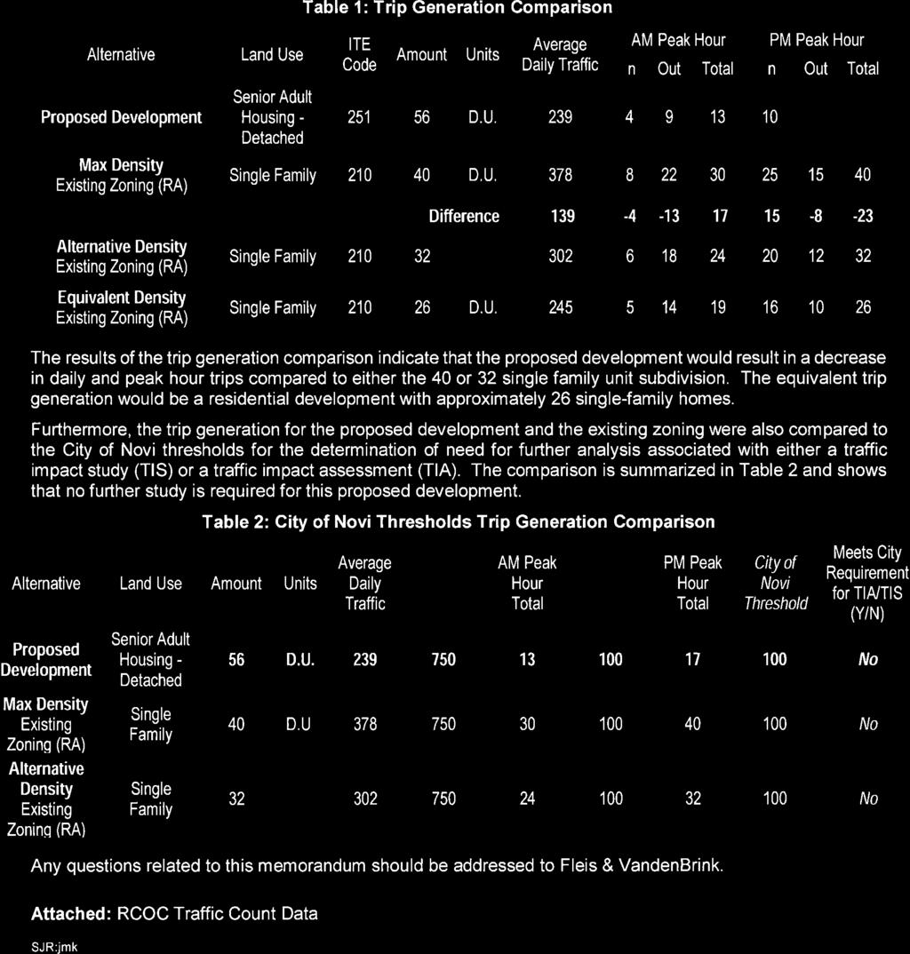
111
112
PLANNED UNIT DEVELOPMENT & SUBDIVISION STAFF REPORT Date: May 18, 2017
 & PUD-0000102-2017 PLANNED UNIT DEVELOPMENT & SUBDIVISION STAFF REPORT Date: May 18, 2017 NAME SUBDIVISION NAME Dauphin Creek Estates Subdivision Dauphin Creek Estates Subdivision LOCATION CITY COUNCIL
ROLL CALL Member Anthony, Member Avdoulos, Member Greco, Member Lynch, Member Maday, Chair Pehrson
 CALL TO ORDER The meeting was called to order at 7:00 PM. PLANNING COMMISSION ACTION SUMMARY CITY OF NOVI Regular Meeting July 11, 2018 7:00 PM Council Chambers Novi Civic Center 45175 W. Ten Mile (248)
PLANNED UNIT DEVELOPMENT Date: April 5, 2018
 PLANNED UNIT DEVELOPMENT Date: April 5, 2018 DEVELOPMENT NAME SUBDIVISION NAME LOCATION Robert Myers Robert Myers 2955 and 2989 Dauphin Street (Southeast corner of Dauphin Street and Sage Avenue) CITY
VILLAGE OF CLEMMONS PLANNING BOARD DRAFT STAFF REPORT. Single Family Residential, Townhomes
 VILLAGE OF CLEMMONS PLANNING BOARD DRAFT STAFF REPORT PETITION INFORMATION Docket # C-212 Staff Megan Ledbetter Petitioner(s) Peacehaven Development LLC Owner(s) Larry Jarvis, William Alexander and Peacehaven
AWH REPORT OF THE PLANNING AND DEVELOPMENT DEPARTMENT FOR APPLICATION FOR REZONING ORDINANCE TO PLANNED UNIT DEVELOPMENT
 AWH REPORT OF THE PLANNING AND DEVELOPMENT DEPARTMENT FOR APPLICATION FOR REZONING ORDINANCE TO PLANNED UNIT DEVELOPMENT MAY 8, 2014 The Planning and Development Department hereby forwards to the Planning
D1 September 11, 2013 Public Hearing APPLICANT:
 D1 September 11, 2013 Public Hearing APPLICANT: BEACH MUNICIPAL FEDERAL CREDIT UNION PROPERTY OWNER: SISTERS II, LLC STAFF PLANNER: Karen Prochilo REQUEST: Conditional Change of Zoning (AG-2 Agriculture
CHESAPEAKE LANDSCAPE ORDINANCE
 CHESAPEAKE LANDSCAPE ORDINANCE CONSERVATION PRESERVATION CZO 19-600 Effective October 16, 2008 BUFFER YARD C PARKING LOT REFORESTATION YEAR 1 REFORESTATION YEAR 4 BUFFER YARD F CBPA REFORESTATION Page
THE PRESERVE AT ISLAND LAKE (PHASE 8) JSP13-69
 JSP13-69") THE PRESERVE AT ISLAND LAKE (PHASE 8) JSP13-69 THE PRESERVE AT ISLAND LAKE (PHASE 8) JSP13-69 Public hearing at the request of Toll Brothers, Inc. for recommendation to City Council for approval to include
THE PRESERVE AT ISLAND LAKE (PHASE 8) JSP13-69 THE PRESERVE AT ISLAND LAKE (PHASE 8) JSP13-69 Public hearing at the request of Toll Brothers, Inc. for recommendation to City Council for approval to include
PART 1: PROJECT SUMMARY. Proposed Land Use: 120 single-family lots. The application is Attachment A. The site plan is Attachment B.
 PART 1: PROJECT SUMMARY Applicant: JBH Development, LLC and Hopper Communities, INC Project Size: +/- 80.48 acres Parcel Number: 01513107, 01513108, 01513109, 01513113, 01513120, 01513121, 01513122, 01513124,
Asbury Chapel Subdivision Sketch Plan
 Asbury Chapel Subdivision Sketch Plan PART 1: PROJECT SUMMARY Applicant: NVR Inc. Project Size: +/- 76.13 acres Parcel Numbers: 02101112,02116101,02116112, 02116113 Current Zoning: Transitional Residential
R E S O L U T I O N. Single-Family Residence/ Church. 2,488 sq. ft. 2,488 sq. ft. Area Parking Required: Church
 R E S O L U T I O N WHEREAS, the Prince George s County Planning Board is charged with the approval of Detailed Site Plans pursuant to Part 3, Division 9 of the Zoning Ordinance of the Prince George s
Baumgarten MPUD. Exhibit 3 Evaluation Criteria
 Pursuant to LDC subsections 10.02.13 B, 10.02.08 F and Chapter 3 G. of the Administrative Code, staff s analysis and recommendation to the Planning Commission, and the Planning Commission s recommendation
ARTICLE 6: Special and Planned Development Districts
 ARTICLE 6: Special and Planned Development Districts 6-10 Traditional Neighborhood Development (TND) District 6-10.10 Purpose and Intent The Traditional Neighborhood Development (TND) District provides
REZONING APPLICATION MPD SUPPLEMENT
 REZONING APPLICATION MPD SUPPLEMENT For Staff Use Only: DATE/TIMESTAMP: ZA# RECEIVED BY: The intent of the Master Planned District (MPD) designation is to allow flexibility in the design and construction
Exhibit A. 8:9 Scuffletown Rural Conservation District
 Exhibit A 8:9 Scuffletown Rural Conservation District 8:9.1 Intent and Purpose The Scuffletown Rural Conservation (SRC) District is intended to provide for residential development that supports the development
SUBMITTAL REQUIREMENTS
 WHEN PROCESS TYPE III IS USED References to Process Type III applications are found in several places in the Milton Municipal Code (MMC), indicating that the development, activity, or use, is permitted
Site Development Plan (SDP) Checklist
 Checklist") Development Services Department 100 N. Wilcox Street, Castle Rock CO 80104 303-660-1393 or CRGov.com Site Development Plan (SDP) Checklist A complete Site Development Plan (SDP) submittal will contain
Development Services Department 100 N. Wilcox Street, Castle Rock CO 80104 303-660-1393 or CRGov.com Site Development Plan (SDP) Checklist A complete Site Development Plan (SDP) submittal will contain
EXHIBIT B PROJECT NARRATIVE POULSBO MEADOWS
 EXHIBIT B PROJECT NARRATIVE POULSBO MEADOWS Name of Project: Poulsbo Meadows; A Planned Residential Development (PRD)/Plat Applicants Name: PBH Group LLC/Byron Harris PO Box 1010 Silverdale, WA 98038 Description
SUBDIVISION, PLANNED UNIT DEVELOPMENT, PLANNING APPROVAL, REZONING & SIDEWALK WAIVER STAFF REPORT Date: February 7, 2013
 SUBDIVISION, PLANNED UNIT DEVELOPMENT, PLANNING APPROVAL, REZONING & SIDEWALK WAIVER STAFF REPORT Date: February 7, 2013 APPLICANT NAME SUBDIVISION NAME DEVELOPMENT NAME LOCATION S. E. Cemeteries of AL
MIXED-USE VILLAGE OVERLAY FLOATING DISTRICT
 MIXED-USE VILLAGE OVERLAY FLOATING DISTRICT Zoning regulations developed by committee to the Planning Board for the Town of DeWitt, NY Issue date: 13 July 2017 revised 3/12/2018, revised 4/26/2018, 5/9/2018
CHAPTER 22 Rural Open Space Community Developments
 CHAPTER 22 Rural Open Space Community Developments Section 22.1 Description and Purpose The intent of this Chapter is to offer property owners an alternative to traditional zoning requirements for rural
MIDTOWN MIXED-USE VILLAGE. TECHNICAL DATA SHEET COMPONENT C-1 FOR PUBLIC HEARING - PETITION NUMBER Project No RZ1.1. Issued.
 N MIDTOWN MIXED-USE VILLAGE TECHNICAL DATA SHEET COMPONENT C- FOR PUBLIC HEARING - PETITION NUMBER 04-00 Project No. 496 Issued Revised SCALE: " = 0' N 0 0 0 40 RZ. c GENERAL PROVISIONS: a. SITE LOCATION.
CITY PLANNING COMMISSION AGENDA ITEM: C STAFF: ROBERT TEGLER FILE NO: CPC PUD QUASI-JUDICIAL
 CPC AGENDA June 8, 2006 Page 37 CITY PLANNING COMMISSION AGENDA ITEM: C STAFF: ROBERT TEGLER FILE NO: CPC PUD 05-294 - QUASI-JUDICIAL PROJECT: APPLICANT: OWNER: PARKWOOD AT WOLF RANCH NASS DESIGN ASSOCIATES
Chapter Master Planned Communities (MPC) District
 District") Sections 14.53.010 Purpose and Intent 14.53.020 Applicability 14.53.030 Procedure 14.53.040 MPC Standards 14.53.050 Required Findings 14.53.010 Purpose and Intent Chapter 14.53 Master Planned Communities
Sections 14.53.010 Purpose and Intent 14.53.020 Applicability 14.53.030 Procedure 14.53.040 MPC Standards 14.53.050 Required Findings 14.53.010 Purpose and Intent Chapter 14.53 Master Planned Communities
SPECIFIC PLAN Requirements
 CITY OF LANCASTER PLANNING DEPARTMENT 44933 Fern Avenue, Lancaster, California 93534 (661) 723-6100 SPECIFIC PLAN Requirements Purpose The purpose of a specific plan is to provide for the logical development
Landscaping Standards
 CHAPTER 29 ARTICLE 403 29.403 Landscaping Standards Purpose: The purpose of this section is to protect and promote the public health, safety and general welfare by requiring landscaping in relation to
ARTICLE 17 SITE PLAN REVIEW
 ARTICLE 17 SITE PLAN REVIEW 17.01 INTENT AND PURPOSE The intent of this section is to provide for consultation and cooperation between the applicant and the township planning commission so that the applicant
Rezoning Petition Post-Hearing Staff Analysis July 31, 2018
 Rezoning Petition 2018-044 Post-Hearing Staff Analysis July 31, 2018 REQUEST Current Zoning: R-3 (single family residential) Proposed Zoning: UR-2(CD) (urban residential, conditional) LOCATION Approximately
PLANNED UNIT DEVELOPMENT PUD For The Proposed Antietam Subdivision Escambia County, Florida. Introduction
 PLANNED UNIT DEVELOPMENT PUD For The Proposed Antietam Subdivision Escambia County, Florida Introduction The project is located in Escambia County approximately 0.75 + miles north of the US Highway 90,
ORDINANCE WHEREAS, this Ordinance is consistent with the City of Winter Garden Comprehensive Plan; and
 ORDINANCE 17-06 AN ORDINANCE OF THE CITY COMMISSION OF THE CITY OF WINTER GARDEN, FLORIDA, CREATING ARTICLE XIV OF CHAPTER 118 OF THE CITY OF WINTER GARDEN CODE OF ORDINANCES PROVIDING FOR THE EAST PLANT
ORDINANCE NO
 ORDINANCE NO. 2013-28 AN ORDINANCE AMENDING CHAPTER 98, ZONING, ARTICLE IV, OVERLAY DISTRICTS AND SPECIAL DISTRICTS OF THE CODE OF ORDINANCES OF WEST MELBOURNE, FLORIDA TO ESTABLISH DIVISION 5, MIXED USE
ROSE SENIOR LIVING AT PROVIDENCE JSP13-81
 ROSE SENIOR LIVING AT PROVIDENCE JSP13-81 Rose Senior Living at Providence JSP13-81 Public hearing at the request of Edward Rose and Sons for recommendation to City Council for approval of a Planned Suburban
Major Subdivision Sketch Plan Checklist
 This checklist provides specific requirements that are apart of the Sketch process. The entire process is described by the Huntersville Subdivision Review Process which details all the submittal and resubmittal
CITY OF KEIZER MASTER PLAN APPLICATION & INFORMATION SHEET
 CITY OF KEIZER MASTER PLAN APPLICATION & INFORMATION SHEET PRE-APPLICATION CONFERENCE Prior to the actual filing of a Master Plan application, it is strongly recommended that the applicant contact Planning
Planning Commission Staff Report June 5, 2008
 Owner/Applicant Taylor Village Sacramento Investments Partners, LP c/o Kim Whitney 1792 Tribute Road #270 Sacramento, CA 95815 Staff Recommendation Planning Commission Staff Report Project: File: Request:
DEPARTMENT OF PLANNING JEFFERSON PARISH, LOUISIANA
 DEPARTMENT OF PLANNING JEFFERSON PARISH, LOUISIANA DESIGN REVIEW REPORT : CPZ-3-1 : (S) Cynthia Lee-Sheng AT LARGE: A Chris Roberts B Elton M. Lagasse ADVERTISING DATES: 06/03/1 06/10/1 06/17/1 PAB PUBLIC
Chapter 10 IMPLEMENTATION RECOMMENDATIONS
 Chapter 10 IMPLEMENTATION RECOMMENDATIONS The recommended land use plan presented in the previous chapter provides a design for the attainment of the urban and rural development and open space preservation
Watertown City Council
 City of Watertown Watertown City Council April 14 th, 2015 Agenda Item: City Comment on Sun Share CUP Application Request for Action: Motion to Approve City Comments regarding CUP Application Department:
Landscape and fencing requirements of this Chapter shall apply to all new landscaped areas.
 Chapter 19.06. Landscaping and Fencing. Sections: 19.06.01. Purpose. 19.06.02. Required Landscaping Improvements. 19.06.03. General Provisions. 19.06.04. Landscaping Plan. 19.06.05. Completion of Landscape
Approved: CITY OF ARDEN HILLS, MINNESOTA PLANNING COMMISSION WEDNESDAY, AUGUST 5, :30 P.M. - ARDEN HILLS CITY HALL
 Approved: CITY OF ARDEN HILLS, MINNESOTA PLANNING COMMISSION WEDNESDAY, AUGUST 5, 2015 6:30 P.M. - ARDEN HILLS CITY HALL PLANNING CASES A. Planning Case 15-016; Final Planned Unit Development Arden Plaza;
Planning & Zoning Commission Staff Report
 Planning & Zoning Commission Staff Report Meeting Date: May 26, 2015 Drafted by: Katherine Harrison-Rogers CASE # Z2886 PROJECT NAME: APPLICANT/ REPRESENTATIVE: Shawna Runyan PROPERTY OWNER: 1840 (previously
Oberlin JSP Required Action Approval/denial of the revised Preliminary Site Plan and revised Woodland Permit
 Oberlin JSP14-42 Oberlin JSP14-42 Public hearing request of Singh Development for Revised Preliminary Site Plan utilizing the Open Space Preservation Option and Revised Woodland Permit approval. The subject
MONTGOMERY COUNTY PLANNING DEPARTMENT THE MARYLAND-NATIONAL CAPITAL PARK AND PLANNING COMMISSION
 MONTGOMERY COUNTY PLANNING DEPARTMENT THE MARYLAND-NATIONAL CAPITAL PARK AND PLANNING COMMISSION MCPB Item No. Date: 12-10-15 Leisure World Clubhouse II Addition Fitness Center, Limited Site Plan Amendment
Village of Glenview Plan Commission
 Village of Glenview Plan Commission STAFF REPORT January 22, 2019 TO: Chairman and Plan Commissioners CASE #: P2018-047 FROM: Community Development Department CASE MANAGER: Tony Repp, Senior Planner SUBJECT:
Request Alternative Compliance (Commercial Parking Lot in Restricted Area) Staff Recommendation Approval. Staff Planner Ashby Moss
 Staff Recommendation Approval. Staff Planner Ashby Moss") Applicant Property Owners Pacific Avenue West, LLC Public Hearing April 11, 2018 City Council Election District Beach Agenda Item 2 Request Alternative Compliance (Commercial Parking Lot in Restricted
Applicant Property Owners Pacific Avenue West, LLC Public Hearing April 11, 2018 City Council Election District Beach Agenda Item 2 Request Alternative Compliance (Commercial Parking Lot in Restricted
APPENDIX A 6 CONCEPTUAL PRELIMINARY PLAN GUIDE AND CHECKLIST FOR MAJOR SUBDIVISIONS CARRBORO DEVELOPMENT GUIDE APPENDIX A
 6 CONCEPTUAL PRELIMINARY PLAN GUIDE AND CHECKLIST FOR MAJOR SUBDIVISIONS Conceptual Preliminary Guide/Checklist for Major Subdivisions Page 1 FORM: REVIEW DATE: CONCEPTUAL PLAN REVIEW 2000 REVIEWED BY:
VILLAGE OF CLEMMONS PLANNING BOARD DRAFT STAFF REPORT
 VILLAGE OF CLEMMONS PLANNING BOARD DRAFT STAFF REPORT PETITION INFORMATION Docket # C-226 Staff Megan Ledbetter Petitioner(s) JBJH Properties, LLC Owner(s) JBJH Properties, LLC Subject Property 5892-49-1766
Urban Planning and Land Use
 Urban Planning and Land Use 701 North 7 th Street, Room 423 Phone: (913) 573-5750 Kansas City, Kansas 66101 Fax: (913) 573-5796 Email: planninginfo@wycokck.org www.wycokck.org/planning To: From: City Planning
ALBEMARLE COUNTY CODE CHAPTER 18 ZONING SECTION 20A NEIGHBORHOOD MODEL - NMD
 CHAPTER 18 ZONING SECTION 20A NEIGHBORHOOD MODEL - NMD Sections: 20A.1 PURPOSE AND INTENT 20A.2 STATUS AS A PLANNED DEVELOPMENT DISTRICT 20A.5 CODES OF DEVELOPMENT 20A.6 PERMITTED USES 20A.7 RESIDENTIAL
PLANNING APPROVAL & PLANNED UNIT DEVELOPMENT Date: November 2, 2017
 PLANNING APPROVAL & PLANNED UNIT DEVELOPMENT Date: November 2, 2017 DEVELOPMENT NAME LOCATION Mobile Christian School 5900 Cottage Hill Road (North side of Cottage Hill Road, 230 ± West of Freemont Drive
12 January 12, 2011 Public Hearing APPLICANT: TAILWIND DEVELOPMENT GROUP,LLC PROPERTY OWNER: CITY OF VIRGINIA BEACH
 12 January 12, 2011 Public Hearing APPLICANT: TAILWIND DEVELOPMENT GROUP,LLC PROPERTY OWNER: CITY OF VIRGINIA BEACH STAFF PLANNER: Faith Christie REQUEST: Conditional Change of Zoning (from PD-H1 Planned
REQUEST Current Zoning: O-15(CD) (office) Proposed Zoning: TOD-M(CD) (transit oriented development mixed-use, conditional)
 (office) Proposed Zoning: TOD-M(CD) (transit oriented development mixed-use, conditional)") Rezoning Petition 2016-117 Zoning Committee Recommendation January 4, 2017 REQUEST Current Zoning: O-15(CD) (office) Proposed Zoning: TOD-M(CD) (transit oriented development mixed-use, conditional) LOCATION
Rezoning Petition 2016-117 Zoning Committee Recommendation January 4, 2017 REQUEST Current Zoning: O-15(CD) (office) Proposed Zoning: TOD-M(CD) (transit oriented development mixed-use, conditional) LOCATION
PLANNING AND ZONING COMMISSION AGENDA MEMORANDUM
 PLANNING AND ZONING COMMISSION AGENDA MEMORANDUM City and County of Broomfield, Colorado To: Planning and Zoning Commission From: John Hilgers, Planning Director Anna Bertanzetti, Principal Planner Meeting
Rezoning Petition Zoning Committee Recommendation August 1, 2017
 Rezoning Petition 2017-090 Zoning Committee Recommendation August 1, 2017 REQUEST LOCATION SUMMARY OF PETITION PROPERTY OWNER PETITIONER AGENT/REPRESENTATIVE COMMUNITY MEETING STATEMENT OF CONSISTENCY
DEPARTMENT OF PLANNING JEFFERSON PARISH, LOUISIANA
 DEPARTMENT OF PLANNING JEFFERSON PARISH, LOUISIANA DESIGN REVIEW REPORT DOCKET NO: : : : Paul D. Johnston AT LARGE: A: Christopher L. Roberts B: Cynthia Lee-Sheng ADVERTISING DATES: PAB PUBLIC HEARING:
Planned Development Review Revisions (Project No. PLNPCM )
") Planned Development Review Revisions (Project No. PLNPCM2014-00139) Standard residential development Planned Development Example: Smaller lot sizes than what is allowed to create open space amenity. What
Planned Development Review Revisions (Project No. PLNPCM2014-00139) Standard residential development Planned Development Example: Smaller lot sizes than what is allowed to create open space amenity. What
Staff Report and Recommendation
 Community Planning and Development Planning Services 201 W. Colfax Ave., Dept. 205 Denver, CO 80202 p: 720.865.2915 f: 720.865.3052 www.denvergov.org/cpd TO: City Council Neighborhoods and Planning Committee
CITY PLANNING COMMISSION AGENDA. ITEM NO: 6.a 6.b STAFF: LONNA THELEN
 Page 156 CITY PLANNING COMMISSION AGENDA ITEM NO: 6.a 6.b STAFF: LONNA THELEN FILE NO(S): A. - CPC ZC 08-00069 QUASI-JUDICIAL B. - CPC CU 08-00070 QUASI-JUDICIAL PROJECT: APPLICANT: OWNER: PHIL LONG VALUCAR
RESIDENTIAL PLANNED UNIT DEVELOPMENT / SUBDIVISION AND REZONING CONCEPT AND DEVELOPMENT STAGE PLAN SUBMITTAL NARRATIVE
 RESIDENTIAL PLANNED UNIT DEVELOPMENT / SUBDIVISION AND REZONING CONCEPT AND DEVELOPMENT STAGE PLAN SUBMITTAL NARRATIVE DEVELOPMENT TEAM DONEGAL SOUTH Maple Grove, Minnesota March 27, 2017 Applicant/Developer/Builder:
Rezoning Petition Pre-Hearing Staff Analysis July 16, 2018
 Rezoning Petition 2018-044 Pre-Hearing Staff Analysis July 16, 2018 REQUEST Current Zoning: R-3 (single family residential) Proposed Zoning: UR-2(CD) (urban residential, conditional) LOCATION Approximately
The Maryland-National Capital Park and Planning Commission Prince George's County Planning Department Development Review Division
 The Maryland-National Capital Park and Planning Commission Prince George's County Planning Department Development Review Division 301-952-3530 Note: Staff reports can be accessed at www.mncppc.org/pgco/planning/plan.htm.
14 October 10, 2012 Public Hearing APPLICANT: MPB, INC
 14 October 10, 2012 Public Hearing APPLICANT: MPB, INC PROPERTY OWNER: MUNDEN & ASSOCIATES, LP STAFF PLANNER: Karen Prochilo REQUEST: Conditional Change of Zoning (AG-1 & AG-2 to Conditional O-2) ADDRESS
Staff Report. Conditional Use PLANNING DIVISION COMMUNITY & ECONOMIC DEVELOPMENT. Salt Lake City Planning Commission
 Staff Report PLANNING DIVISION COMMUNITY & ECONOMIC DEVELOPMENT To: From: Salt Lake City Planning Commission Maryann Pickering, Principal Planner (801) 535-7660 Date: December 10, 2014 Re: Church of Scientology
Application Number: SD Project Name: Walton Farms Preliminary Subdivision (acting as Master Plan)
") STAFF REPORT Town of Clayton Planning Department 111 E. Second Street, Clayton, NC 27520 P.O. Box 879, Clayton, NC 27528 Phone: 919-553-5002 Fax: 919-553-1720 Planning Board May 22, 2017 Application Number:
STAFF REPORT Town of Clayton Planning Department 111 E. Second Street, Clayton, NC 27520 P.O. Box 879, Clayton, NC 27528 Phone: 919-553-5002 Fax: 919-553-1720 Planning Board May 22, 2017 Application Number:
PLANNED UNIT DEVELOPMENT STAFF REPORT Date: June 2, 2016
 # 9 ZON2016-01032 PLANNED UNIT DEVELOPMENT STAFF REPORT Date: June 2, 2016 DEVELOPMENT NAME JJT Properties LLC LOCATION 1147 & 1151 East I-65 Service Road South and 1180 Sledge Drive (Southeast corner
DETROIT CATHOLIC CENTRAL PARKING EXPANSION JSP 14-12
 DETROIT CATHOLIC CENTRAL PARKING EXPANSION JSP 14-12 Detroit Catholic Central Parking Expansion JSP14-12 Public hearing at the request of Catholic Central High School for approval of the Preliminary Site
Rezoning Petition Pre-Hearing Staff Analysis May 21, 2018
 Rezoning Petition 2018-018 Pre-Hearing Staff Analysis May 21, 2018 REQUEST Current Zoning: R-5 (single family residential), R-5 HD-O (single family residential, historic district overlay) and B-2(CD) HD-O
Novi Crossing SP10-06 WITH Zoning Map Amendment
 ( IITV OF ~C~ ~~~ NOV. cityofnovi.or/2: Novi Crossing SP10-06 WITH Zoning Map Amendment 18.696 NOVI CROSSING, SP10-06 WITH ZONING MAP AMENDMENT 18.696 Public Hearing of the request of Ten & Beck, LLC,
VILLAGE OF CLEMMONS PLANNING BOARD DRAFT STAFF REPORT
 VILLAGE OF CLEMMONS PLANNING BOARD DRAFT STAFF REPORT PETITION INFORMATION Docket # C-214 Staff Megan Ledbetter Petitioner(s) Summit Healthcare Group Owner(s) Wake Forest University Health Services Subject
SECTION UNIFIED DEVELOPMENT ORDINANCE SECTION Part 1 Ordinance. ARTICLE 1 Zoning Districts
 SECTION 1-100 UNIFIED DEVELOPMENT ORDINANCE SECTION 1-300 Part 1 Ordinance SECTION 1-100. Introduction. ARTICLE 1 Zoning Districts Crystal Lake strives to maintain a balance of various land uses for a
ARTICLE 9: Landscaping
 ARTICLE 9: Landscaping 9-10 Legislative Intent The purpose of this Article is to regulate the planting and preservation of landscape materials; to facilitate the creation of an attractive and healthy environment;
PLNPCM Carl s Jr. Commercial Parking Lot at Redwood Road and 1700 South
 Staff Report PLANNING DIVISION COMMUNITY & NEIGHBORHOODS To: Salt Lake City Planning Commission From: Casey Stewart; 801-535-6260 Date: November 4, 2016 Re: PLNPCM2015-00874 Carl s Jr. Commercial Parking
City of Yelm. Tahoma Terra Final Master Plan Development Guidelines. Table of Contents
 City of Yelm Tahoma Terra Final Master Plan Development Guidelines Table of Contents Table of Contents... 1 Purpose... 2 Low Density Residential (R4-6)... 3 Moderate Density Residential (R6-10)... 5 Neighborhood
Gadsden County Planning Commission Agenda Request
 Date of Meeting: November 16, 2017 To: From: Through: Subject: Gadsden County Planning Commission Agenda Request Honorable Chairperson and Members of the Board Jill A. Jeglie, AICP, Senior Planner Clyde
Mitchell Ranch South MPUD Application for Master Planned Unit Development Approval Project Narrative. Introduction
 Mitchell Ranch South MPUD Application for Master Planned Unit Development Approval Project Narrative Introduction Mitchell Ranch South is a proposed single family (detached) residential development on
Christopher M. Price, AICP Director of Planning February 7, 2014 STAFF REPORT
 COUNTY OF PRINCE WILLIAM 5 County Complex Court, Prince William, Virginia 22192-9201 PLANNING MAIN (703) 792-7615 FAX (703) 792-4758 OFFICE www.pwcgov.org/planning Christopher M. Price, AICP Director of
CASE NUMBER: 16SN0701 APPLICANT: Hanky, LLC
 STAFF S ANALYSIS AND RECOMMENDATION Planning Commission (CPC) Public Hearing Date: MAY 17, 2016 CPC Time Remaining: 100 DAYS Applicant s Agent: DANIEL L. CASKIE (804-569-7060) Applicant s Contact: MICHAEL
4 January 11, 2012 Public Hearing APPLICANT:
 . 4 January 11, 2012 Public Hearing APPLICANT: MID-ATLANTIC AUTO PROPERTY OWNER: DZR, LLC STAFF PLANNER: Leslie Bonilla REQUEST: Conditional Use Permit (truck rental, automobile service, and automotive/bulk
ARTICLE IV: DEVELOPMENT STANDARDS 404 MASTER PLANNING
 IV 13 404 MASTER PLANNING Master Planning through the Site Analysis (Master Planning Site Analysis) or Planned Development (Master Planning Planned Development) is provided to encourage development which
CITY OF ZEELAND PLANNING COMMISSION
 APPLICATION FOR SITE PLAN REVIEW AND SPECIAL LAND USE Date City Official App. Filing Fee Rec'd ($350) NOTE TO APPLICANT: Please submit this application for Site Plan Review along with twenty (20) copies
#8) T-1409 CENTENNIAL & LAMB TENTATIVE MAP
 T-1409 CENTENNIAL & LAMB TENTATIVE MAP") #8) T-1409 CENTENNIAL & LAMB TENTATIVE MAP STAFF REPORT To: Planning Commission Meeting Date: June 14, 2017 Item: T-1409 Prepared By: Robert Eastman GENERAL INFORMATION: Applicant: Property Owner(s): Requested
#8) T-1409 CENTENNIAL & LAMB TENTATIVE MAP STAFF REPORT To: Planning Commission Meeting Date: June 14, 2017 Item: T-1409 Prepared By: Robert Eastman GENERAL INFORMATION: Applicant: Property Owner(s): Requested
Chapter Purpose and Intent. 7.2 Applicability. 7.3 General Provisions RECREATIONAL OPEN SPACE
 Chapter 7. RECREATIONAL OPEN SPACE 7.1 Purpose and Intent The intent of this Chapter is to provide for centrally located, unencumbered land as neighborhood recreational open space and not to permit the
BUFFERS, TREE PROTECTION AND LANDSCAPING. Sec Purpose and Intent.
 ARTICLE 20 BUFFERS, TREE PROTECTION AND LANDSCAPING Sec. 20.1. Purpose and Intent. Trees improve air and water quality, reduce soil erosion, reduce noise and glare, provide habitat for desirable wildlife,
THE CITY OF MOBILE, ALABAMA
 THE CITY OF MOBILE, ALABAMA LETTER OF DECISION Ark of Safety, Inc. Mobile, AL 36617 Re: (Northwest corner of Main Street and First Avenue, extending to the Southwest corner of Esau Avenue and Main Street.)
ARLINGTON COUNTY, VIRGINIA
 ARLINGTON COUNTY, VIRGINIA County Board Agenda Item Meeting of September 19, 2015 DATE: September 11, 2015 SUBJECTS: Outdoor Café at Citizen Burger Bar A. SP# 418 Site Plan Amendment to modify an approved
Request Conditional Rezoning (R-10 Residential & I-1 Light Industrial to Conditional I-1 Light Industrial) Staff Recommendation Approval
 Staff Recommendation Approval") Applicant & Property Owner Public Hearing January 9, 2019 City Council Election District Beach Agenda Item 1 Request Conditional Rezoning (R-10 Residential & I-1 Light Industrial to Conditional I-1 Light
Applicant & Property Owner Public Hearing January 9, 2019 City Council Election District Beach Agenda Item 1 Request Conditional Rezoning (R-10 Residential & I-1 Light Industrial to Conditional I-1 Light
Town of Portola Valley General Plan. Nathhorst Triangle Area Plan
 Town of Portola Valley General Plan Amended December 10, 1997 Table of Contents Introduction... 1 Planning Area... 1 Objectives... 2 Principles... 2 Standards... 4 Description... 4 Community Commercial...
PART 1: PROJECT SUMMARY. The application is Attachment A. The site plan is Attachment B.
 Belleterre Subdivision Sketch Plan Town Board 8.7.17 Belleterre Subdivision Sketch Plan PART 1: PROJECT SUMMARY Applicant: Bowman Development Project Size: +/- 20.85 acres Parcel Number: 01115104 and 01115121
CHAPTER SPECIAL PURPOSE AND OVERLAY ZONING DISTRICTS
 Special Purpose and Overlay Zoning Districts 106.28.010 CHAPTER 106.28 - SPECIAL PURPOSE AND OVERLAY ZONING DISTRICTS SPECIAL PURPOSE AND OVERLAY ZONING DISTRICTS Sections: 106.28.010 - Purpose 106.28.020
November 21, Planning Commission Charter Township of Lyon Grand River Ave. New Hudson, MI 48165
 Planning Commission Charter Township of Lyon 58000 Grand River Ave. New Hudson, MI 48165 Subject: AP-18-68; 11 Mile and Milford Road Park, Site Plan Review #1 Based on site plan dated 11/12/18 Location:
PLANNING COMMISSION. Submitted
 PLANNING COMMISSION City Hall 1275 Main Street El Centro, CA 92243 Submitted PLANNING COMMISSION ACTION ITEM (1844) Meeting: 05/10/16 12:00 AM Department: Community Development Category: Public Hearing
GENERAL LANDSCAPE PROVISIONS. The following landscape provisions shall be adhered to by all land uses unless otherwise noted:
 CHAPTER 1.18 Sections: 1.18.005 Purpose. 1.18.010 Landscaping, Buffering, and Fencing Improvements Required. 1.18.015 General Landscape Provisions. 1.18.020 Landscaping Plan. 1.18.025 Single-Family Dwellings
5.1.1 The streetscape along US Highway 64 (Brevard Road); and, The built environment within new residential developments; and,
; and, The built environment within new residential developments; and,") Article 5. Landscaping 5.1 Purpose The Town of Laurel Park s landscape standards are designed to create a beautiful, aesthetically pleasing built environment that will complement and enhance community
Article 5. Landscaping 5.1 Purpose The Town of Laurel Park s landscape standards are designed to create a beautiful, aesthetically pleasing built environment that will complement and enhance community
ZONING AMENDMENT, PLANNED UNIT DEVELOPMENT & SUBDIVISION STAFF REPORT Date: March 20, 2008
 ZONING AMENDMENT, PLANNED UNIT DEVELOPMENT & SUBDIVISION STAFF REPORT Date: March 20, 2008 NAME SUBDIVISION NAME LOCATION Joseph Mramor Mramor s Addition to Weinacker Avenue Subdivision 900 Weinacker Avenue
CHAPTER ADDITIONAL REQUIREMENTS IN THE NC, NEIGHBORHOOD COMMERCIAL ZONE
 CITY OF MOSES LAKE MUNICIPAL CODE CHAPTER 18.31 ADDITIONAL REQUIREMENTS IN THE NC, NEIGHBORHOOD COMMERCIAL ZONE Sections: 18.31.010 Purpose 18.31.020 Minimum Lot Area 18.31.030 Setbacks 18.31.040 Maximum
Request Alternative Compliance to the prescribed criteria of the Oceanfront Resort District Form-Based Code. Staff Planner Kristine Gay
 Applicant/Owner Ocean Rental Properties, LLC Public Hearing April 13, 2016 City Council Election District Beach Agenda Item 1 Request Alternative Compliance to the prescribed criteria of the Oceanfront
Narcoossee Roadway Corridor
 Community Meeting Narcoossee Roadway Corridor April 5, 2012 Meeting Agenda Purpose of Meeting Continuation of Study Update Process (Previous Meetings Oct. & Nov., 2011) Tonight s Objective Review Proposals
The petition proposes the development of five townhomes on a vacant parcel between Charlotte Latin School and Providence Presbyterian Church.
 Rezoning Petition 2017-202 Final Staff Analysis June 18, 2018 REQUEST LOCATION Current Zoning: R-3 (single family residential) Proposed Zoning: UR-2(CD) (urban residential, conditional) with five-year
Note: Staff reports can be accessed at Zone: I-3. Tier:
 The Maryland-National Capital Park and Planning Commission Prince George s County Planning Department Development Review Division 301-952-3530 Note: Staff reports can be accessed at www.mncppc.org/pgco/planning/plan.htm.
The subject site plan amendment proposes the following revisions to the approved site plan:
 PROPOSED AMENDMENT The subject site plan amendment proposes the following revisions to the approved site plan: 1. The building footprint was modified to accommodate the revised architectural design. 2.