Workshop: Ottawa River North Shore Improvement Plan
|
|
|
- Jesse Anthony Hicks
- 5 years ago
- Views:
Transcription

1 Workshop: Ottawa River North Shore Improvement Plan Consultation Report, November 25, 2014
 sector.")
2 Planning Workshop: Ottawa River North Shore Improvement Plan I Description Background The National Capital Commission (NCC) would like to develop an improvement plan for the federal lands located in the Capital s core area on the north shore of the Ottawa River, including the Ruisseau de la Brasserie (Brewery Creek) sector. Objective The creation of an improvement plan for federal lands in the Capital core area on the north shore of the Ottawa River will provide a consistent, overall planning concept for federal lands in the area by putting forward planning proposals and possible uses for the lands, in addition to establishing design principles and guidelines. The study area is composed of federal lands on the shoreline between Laurier Street and the river, from Jacques-Cartier Park North to Portageurs Park, including NCC lands between Brewery Creek and Montcalm Street. The map of the area that was the subject of the consultation is shown in Appendix 1: Study Area Plan Development Phases Phase 1: Report on Existing Conditions and Issues Phase 2: Preliminary Concept and Design Principles Phase 3: Final Plan II Consultation Process Overview Date and Location: Tuesday, November 25, 2014, at the Capital Urbanism Lab, 40 Elgin Street, Ottawa Time: 7 pm to 9 pm Format: Planning workshop 1
3 Purpose of consultation The purpose of the consultation was to gather participants ideas and comments on the use and management of shoreline parks and green space in the years to come. The results of the consultation will contribute to the creation of the Ottawa River North Shore Improvement Plan and a future planning vision for NCC lands in designated areas. Consultation process and tools Workshop: The discussion at each table centred on the lands under study. Using a guide-questionnaire, participants were asked to identify the strong points and drawbacks of the lands in question, write down or draw their ideas, and add their comments to a map. Appendix 2 contains the comments entered on the sector maps. Plenary session: Discussions were summarized, and written comments were gathered via a questionnaire. Online consultation: A questionnaire was made available online between November 25 and December 19, Invitations and promotion Participants An invitation was sent by to the following stakeholders 1 : o Interest groups (residents, environmental, tourism and business associations) o Elected municipal officials o Municipal and federal partners The media were asked to participate. The workshop was advertised in local newspapers. Facebook and Twitter messages promoted the workshop. Community Thirty participants representing 14 interest groups attended the workshop. Eleven people answered the online questionnaire. 1. Members of First Nations participated in an ongoing dialogue and separate mobilization process. 2
4 Elected officials Richard Bégin, City Councillor and Chair of the Comité consultatif d urbanisme (urban planning advisory committee), Ville de Gatineau Mike Dugan, City Councillor, Ville de Gatineau Denise Laferrière, City Councillor, Ville de Gatineau Louise Boudrias, City Councillor, Chair, Board of Directors, Place des festivals Media The following media attended: Le Droit TC Media Gatineau III Consultation highlights In terms of a plan for the area, participants want: To highlight the natural character of the lands. To improve access to the water by providing facilities and activities near or on the water. To maintain and improve the continuity of public spaces with trails and navigation routes; to create an island tour. To promote site-related historical interpretation activities. To establish a theme that connects all of the lands and to create an open-air museum. IV Public comments Vision While acknowledging the differences between the various sectors, participants defined the character and the intended visitor experience or atmosphere for the entire area under study: o Enhance the rich historical heritage of the sites and the cultural convergence they represent. These locations symbolize the gateway to Quebec and the region s history and culture; they provide an opportunity to rediscover Hull Island. o Develop the river and natural heritage of the area; take back ownership of the river by facilitating access to it. o Make the site a place for gatherings and cultural activities, a meeting place for the enjoyment of families and the general public. o Provide access to the site by public transit, on foot, by bicycle or car. 3
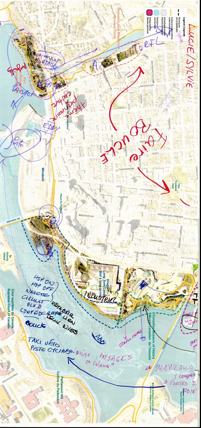
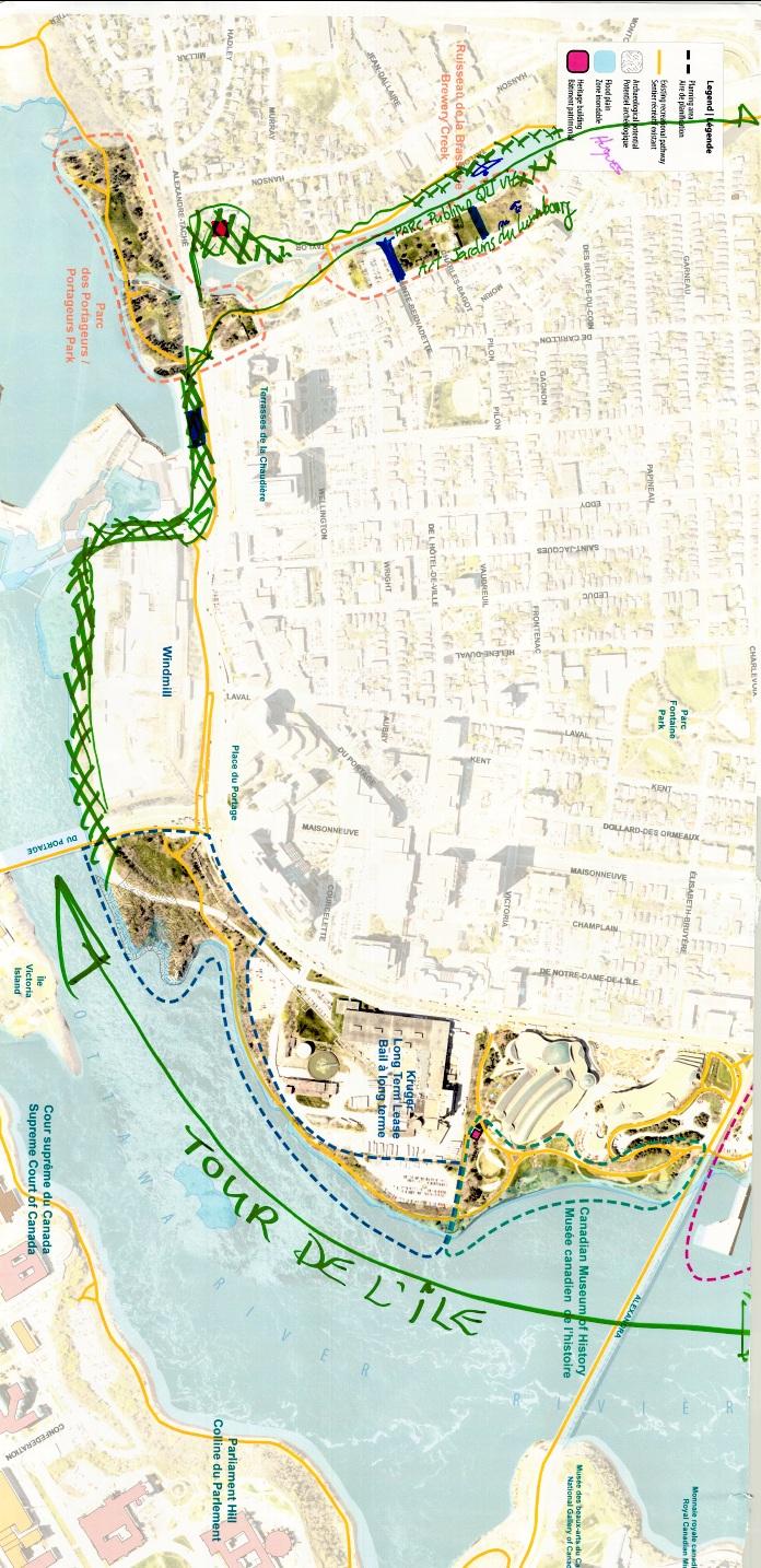
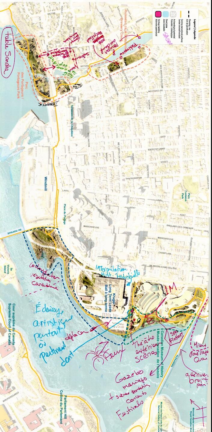
5 Participants identified the strong points and drawbacks of each sector and offered suggestions. Portageurs Park and Brewery Creek Some of the strong points included the following: The area s rich history (portage and the Wright-Scott House). The location is the jumping off point for the development of the Ottawa region, and part of the identity of the city and its residents. Its current and developing cultural attractions (Théâtre de l Île, public art, Place de la Francophonie). Attractive potential from both a recreational perspective (walking, running, canoeing around the island and skating) and a contemplative perspective (public benches, view of the falls and hydroelectric works). A gateway to the Capital. Drawbacks included the following: The sites state of neglect (contaminated lands, creek retaining wall and neighbouring infrastructure); the creek s changing water level; the limited expanse of public space. Lack of consistent planning of the site: absence of public amenities (washrooms, drinking fountains and lighting); strategic lands for activities used as parking lots; remoteness from other sites; and poor pedestrian and bicycle connections. Potential development of amenities is limited by the permanent exhibition at the Portageurs Park. Intervention is complicated by the large number of partners involved. Planning suggestions included the following: Include the Wright-Scott House in the area covered by the shoreline plan. Enhance the sector s landscape and cultural/heritage components. Improve cultural components by presenting activities smaller in scale than those held in the Jacques-Cartier Park sector; add visual art works; commemorate the birthday of painter Jean Dallaire; turn the Wright-Scott House into an educational or interpretation centre. Review the overall development of Brewery Creek and its shorelines. Improve the network of connections between Portageurs Park in the city and shoreline on the Domtar lands, ideally to the south of the E. B. Eddy heritage 4
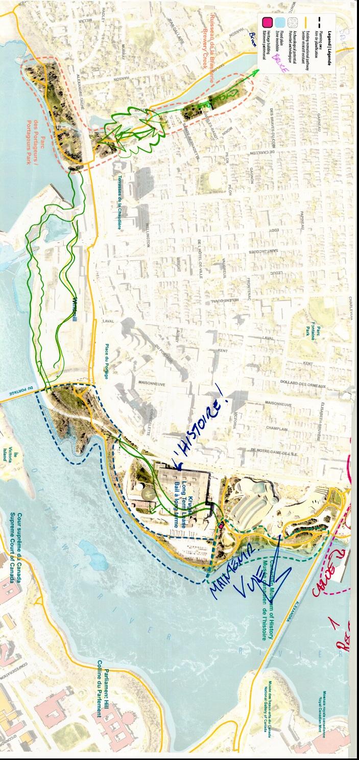
6 building; extend the bicycle path connection to the west of the creek; build a bridge between the Théâtre de l Île and the Wright-Scott House property. Create community partnerships to expand the range of available services. Expand the range of available recreational activities (kayaking, skating rink, natural playground). Sector behind the Kruger plant Some of the strong points included the following: Recreational pathways along the river and the corridor s natural character. Scenic views of the river, the Parliament Buildings and Ottawa. Heritage elements: the digester tower; Kruger is the last vestige of the location s industrial past. Drawbacks included the following: The limited aesthetic appeal of an industrial area. Poor access to the recreational pathway to the west of the plant. Poor access to the recreational pathway near Alexandre-Taché Boulevard. Shoreline instability, i.e., erosion problems. The area s isolation facilitates illicit activities. Lack of user services. Planning suggestions included the following: Convert the parking lot behind the Kruger plant into a natural, public space. Retain the bicycle path and maintain it in winter; improve lighting; ensure a connection between the Domtar plant and Portageurs Park. Provide interpretation of the site s industrial history, its connection to the river and its importance in the region s economy and growth. Create an official access way to the scenic site east of the Portage Bridge at Scott Point. Make room for public art and provide space for graffiti artists on walls and under the Portage Bridge. 5
7 Canadian Museum of History Some of the strong points included the following: Canadian Museum of History; elegant design; spectacular views; the natural character of the area; the high-quality recreational pathway. Contact with the river and access to the waterway. Cultural networking and activities or cultural events for everyone; extensive use in summer; very pleasant atmosphere. Access to public washrooms. Drawbacks included the following: River is inaccessible and shoreline is artificial. Limited programming; passive outdoor space of limited appeal to visitors. Under-utilization of river shuttle; no link to other sites on the north and south shores. Few locations for sitting or eating outdoors in the area; poor pedestrian access; limited restaurant services. Planning suggestions included the following: Heighten the profile of Aboriginal culture, as well as interpretation activities pertaining to shoreline wildlife and the industrial sector, particularly the digester tower; presentation of historical information. Improve recreational services: children s play areas (including water games); floating spa, Rabaska canoe tours, tables and park benches; a wedding pavilion; extend the hours of museum services. Expand river taxi services to include other sites, and improve related facilities (bicycle stands, umbrellas, lighting, etc.). Install a covered stage for cultural programming performances. Maintain the bicycle connection. Reduce grassy areas, and restore shorelines to their natural condition. Jacques-Cartier Park South Some of the strong points included the following: Proximity of the Canadian Museum of History, the downtown cores of Ottawa and Gatineau; area accessible on foot; plenty of parking available. 6
8 Site of large cultural gatherings in summer and winter. Heritage, historical and archaeological wealth (Maison Charron heritage building). River access: natural shorelines, boating and fishing potential. Continuity and quality of the recreational pathway system linking all of the parks. Drawbacks included the following: Infrastructure and landscaping lower in quality than other parks in the Capital. Under-interpretation of the area. Infrequency of activities at certain times of the year and under-utilization of heritage buildings. Limited services: parking during activities, public washrooms; difficulty in using the land in winter; river access non-existent between north and south shore sites. Illicit activities in remote locations of the area. Impact of music festivals on the adjoining neighbourhood. Land developed up to waterway in certain locations. Limited recreational space due to wetlands and uneven grade. Presence of Canada geese on the pathway and lawns. Planning suggestions included the following: Preserve use of the area as the site of major cultural and sporting events (on land or water) for the whole family. Develop the sector to make it a world-class site (botanical garden, flower exhibition); add a fountain. Enlarge the marina and develop a beach. When no major events are in progress, develop permanent activity areas (historical interpretation, theatre, museum-related exhibitions); organize a public market space; exhibit snow sculptures. Offer services: river taxi, bike taxi, shuttle, directional signage, public washrooms, drinking fountains, healthy food vendor booths, picnic areas. Increase the number of parking spaces by building an underground parking lot near the convent; reserve space for visitor parking at the marina. Improve pedestrian access to Jacques-Cartier Park from Verdun and St-Étienne streets. Illuminate historical buildings. 7
9 Improve lighting at the site for greater security. Naturalize the shoreline more, plant trees and create access ways to the water, especially for swimming. Install a patio. Reduce noise from the bridge. Jacques-Cartier Park North Some of the strong points included the following: The possibility of developing water access sites. The natural character of the park as a tranquil, uncrowded location with vast open spaces; the park s location at the mouth of Brewery Creek and its magnificent view of Rideau Falls. The possibility of its use as the site of major activities. Its archaeological interpretation potential. Bicycle path network and services provided at the Maison du vélo (the Gilmour Hughson Lumber Company building) Some of the drawbacks included the following: Access: the area is isolated; Jacques-Cartier North has limited parking and public transit; pedestrian access is difficult. Limited facilities: public washrooms and drinking fountains; signage for the Maison du vélo; no river access and no shuttle transportation to the south shore. The Maison du vélo is difficult to find; interpretation of its industrial history is nonexistent. Planning suggestions included the following: Capitalize on the sector s major potential for hosting large-scale events; create permanent facilities to accommodate performances; maintain a balance between periods of activity and periods of calm. Develop the site while conserving existing vegetation and densified tree planting to create an urban forest. Promote the Hull Island tour by featuring pathways or Brewery Creek. Highlight Aboriginal culture. Turn the Gilmour Hughson Lumber Company building into an interpretation centre and add a public art component. 8
10 Develop lookouts downstream from the river and at the overpass behind the convent. Expand the range of services provided at the Maison du vélo: include adapted bicycle, kayak, canoe and kite rentals. Expand the amenities available in the area: public washrooms, benches, river taxis, a boat launch for non-motorized watercraft; offer winter activities such as snowshoeing, cross-country skiing or skating. Complete the missing link in the recreational pathway network between Fournier Boulevard and the highway; make the pathway safer by lighting portions of it. Create an entrance to the sector at Sacré-Cœur Street or from the highway; review the pedestrian entry way. Create play areas for children. Priority ideas The main ideas put forward are listed below and grouped into five themes: Site development: Protect the views (Kruger lookout); building and bridge illumination; shoreline development that retains the natural character of the site; installation of pedestrian streets bordered by shops; respect for differences among the sectors. Interpretation: Open-air museum, a range of themes, historical and natural heritage interpretation, sculptures and monuments. Occasional performance sites: A window on Quebec, a place for activities and performances. Recreational activities: Hull Island tour, winter activities, bicycle connections, river activities, children s play areas. Infrastructure and services: washrooms, water taxis, public transit, recreational paths, signage, safety features. V Compilation of results The NCC will use the ideas and comments gathered during the public consultation to develop a preliminary concept for the Ottawa River shoreline improvement plan. The strong points and drawbacks that participants identified will help clarify existing site conditions and guide the proposed actions. 9
11 VI Next Steps The next public consultation will take place on June 17, 2015, and will focus on the preliminary concept. 10

12 Appendix 1 Study area 11

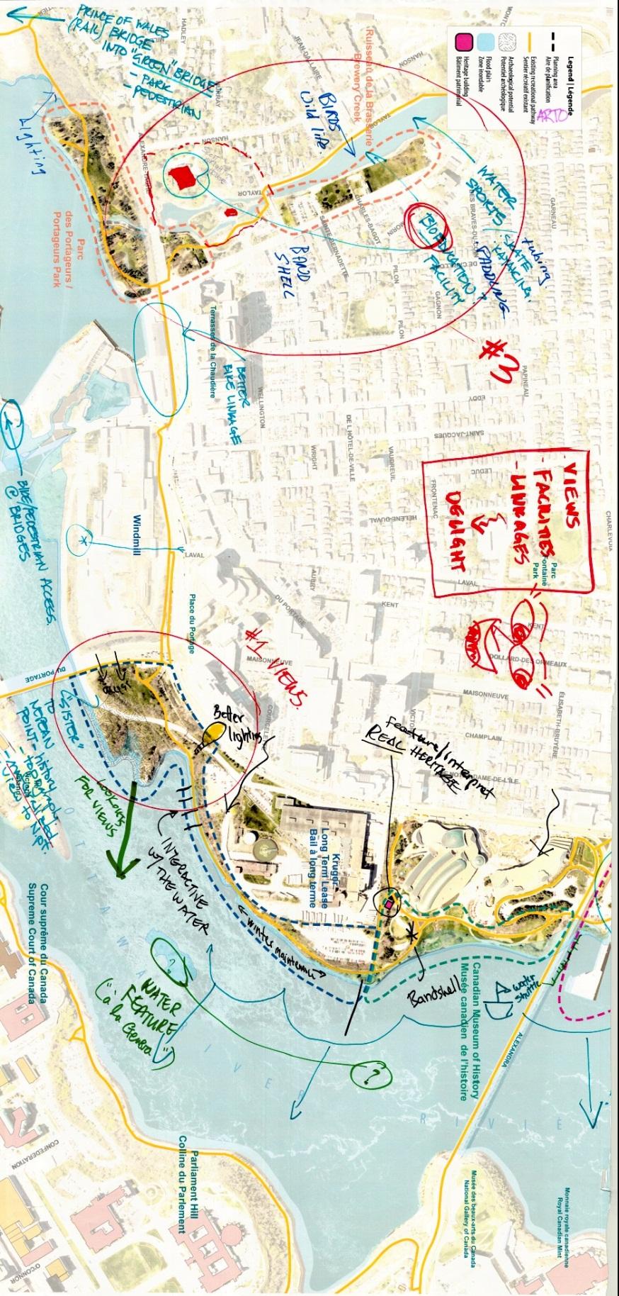
13 Appendix 2 Comments based on sector maps Group 1 Map 1 12
14 Map 2 13

15 Group 2 Map 1 14
16 Map 2 15

17 Group 3 Map 1 16
18 Map 2 17

19 Group 4 Map 1 18
20 Map 2 19

21 Group 5 Map 1 20
22 Map 2 21
Nepean Point CONSULTATION REPORT JUNE 2014
 Nepean Point CONSULTATION REPORT JUNE 2014 Workshop: Nepean Point I Project description Objective: With the renewal of Nepean Point, the National Capital Commission (NCC) presented a project to develop
Site visit and public consultation: Bronson Pulp Mill ruins public access and Richmond Landing shoreline access. Consultation Report
 Site visit and public consultation: Bronson Pulp Mill ruins public access and Richmond Landing shoreline access Consultation Report Site visit and public consultation: Bronson Pulp Mill ruins public access
Ottawa River North Shore Parklands Plan. April 2018
 Ottawa River North Shore Parklands Plan April 2018 2 Ottawa River North Shore Parklands Plan April 2018 OTTAWA RIVER NORTH SHORE PARKLANDS PLAN 3 National Capital Commission 202 40 Elgin Street, Ottawa,
10.0 Open Space and Public Realm
 10.0 Open Space and Public Realm 10.0 Open Space and Public Realm The Public Open Space System is comprised of: outdoor spaces available for public use that are either publicly owned (e.g., parks and
Plan for Canada s Capital,
 Plan for Canada s Capital, 2017 2067 Public Consultation Report Summer 2016 Plan for Canada s Capital, 2017 2067 Public Consultation Report I Description Background The National Capital Commission (NCC)
Emerson Park Master Plan Update. Public Meeting III August 27, 2014
 Emerson Park Master Plan Update Public Meeting III August 27, 2014 Meeting Agenda: Project Update Presentation of Master Plan Components Discussion and Feedback The Path Forward: Building on the Concept
Animating the Rideau Canal December 2013
 Executive Summary Animating the Rideau Canal December 2013 Why study the Rideau Canal? The Rideau Canal has been an important part of Ottawa throughout its history, and has shaped and been shaped by the
Denton. A. Downtown Task Force
 2 Public Involvement Early and ongoing public involvement was solicited so that the public had ample opportunity to help direct the DTIP s concepts and implementation strategies. The residents of Denton
CONSULTATION SUMMARY. Public and Online Consultation #1
 CONSULTATION SUMMARY Public and Online Consultation #1 On December 4, 2013 the Ministry of Tourism, Culture and Sport launched the first public consultation for the urban park and waterfront trail at Ontario
A Vision for Walnut Creek
 A Vision for Walnut Creek Photo: City of Clive Walnut Creek Booklet 8 of 8 Greater Des Moines Water Trails and Greenways 1 Table of Contents Booklet 1: Water Trails Strategies and Policies Booklet 2: Beaver
West Eau Claire Park & Public Realm Plan. What We Heard Report. Prepared by: O2 Planning + Design Inc. (O2) Prepared for: The City of Calgary
 Prepared for: The City of Calgary") West Eau Claire Park & Public Realm Plan What We Heard Report Prepared by: O2 Planning + Design Inc. (O2) Prepared for: The City of Calgary September 18, 2014 TABLE OF CONTENTS TABLE OF CONTENTS... II
West Eau Claire Park & Public Realm Plan What We Heard Report Prepared by: O2 Planning + Design Inc. (O2) Prepared for: The City of Calgary September 18, 2014 TABLE OF CONTENTS TABLE OF CONTENTS... II
Welcome. Community Consultation Meeting November 28, Review and discuss the Bathurst Quay Neighbourhood Plan Framework
 Welcome Community Consultation Meeting November 28, 2016 Why Are We Here Today? Review and discuss the Bathurst Quay Neighbourhood Plan Framework Review and discuss an Action Plan for Implementation Next
Don Mills Crossing Study and Celestica Lands Development Application Community Meeting, Open House, and Breakout Discussions
 Consultation Summary Don Mills Crossing Study and Celestica Lands Development Application Community Meeting, Open House, and Breakout Discussions This report is not intended to provide a verbatim transcript
Section 1 Introduction
 Section 1 Section 1,, describes the role of the Official Plan. The Official Plan is one of five growth management plans that was completed under the umbrella of Ottawa 20/20. 1.1 The Role of the Official
Capital Urban Lands Plan and Parkways Policy Review. Public Consultation Report
 Capital Urban Lands Plan and Parkways Policy Review Public Consultation Report 1 HIGHLIGHTS Highlights In March 2014, the National Capital Commission (NCC) held public consultations on the Capital Urban
Sherwood Forest Park REVITALIZATION PLAN. Public Meeting (P.I.C) # 3 JUNE / 25 /2015
 # 3 JUNE / 25 /2015") Sherwood Forest Park REVITALIZATION PLAN Public Meeting (P.I.C) # 3 JUNE / 25 /2015 1 Agenda i. Where we are in the process and schedule ii. Consultation process iii. Key messages from PIC#2 iv. Purpose
Sherwood Forest Park REVITALIZATION PLAN Public Meeting (P.I.C) # 3 JUNE / 25 /2015 1 Agenda i. Where we are in the process and schedule ii. Consultation process iii. Key messages from PIC#2 iv. Purpose
Blood Alley Square/Trounce Alley Redesign
 June 216 Kick-Off Events Questionnaire and Engagement Summary Background The City of Vancouver is redesigning Blood Alley Square and Trounce Alley, important public spaces in the heart of Gastown, which
Highest & Best Use Study Marina Park Lands
 Executive Summary of Report MARCH 2006 TABLE OF CONTENTS 1. Introduction...1 2. Study Process...2 3. Highest And Best Use Program...3 4. Concept Plan...8 5. Public Area Animation...9 6. Marina Park Implementation
Parks Master Plan Implementation: Phase I Waterfront Use and Design REPORT #: September 7, 2016 File #
 0 'O DI Lan-171-14 1 - THE CORPORATION OF THE TOWN OF COBOURG..,. STAFF REPORT TO: FROM: Mayor and Members of Council Dean A. Hustwick, Director of Recreation and Culture DATE OF MEETING: Committee of
Highland Falls Waterfront Redevelopment Feasibility Study Village Board Meeting March 20, 2017
 Village Board Meeting March 20, 2017 Agenda I. Public Meeting #1 Visioning Summary II. Public Meeting #2 Comment Summary III. IV. IV. Case Study: Milton Train Station Schematic Design Concepts Schedule/Next
Report to: Development Services Committee Report Date: April 24, 2017
 SUBJECT: Cornell Rouge National Urban Park Gateway - Report on Design Charrette and Next Steps PREPARED BY: Lilli Duoba, MES, MCIP, RPP, Manager, Natural Heritage (ext. 7925) REVIEWED BY: Marg Wouters,
Strategies/Actions Priority List
 Strengthening the Creative Sector: Build stronger relationships with, and between, cultural organizations and businesses and increase opportunities for working together to build capacity within organizations.
RE: Application for FERC Project No , Scott s Mill dam hydropower proposal
 RE: Application for FERC Project No. 14425, Scott s Mill dam hydropower proposal To Whom It May Concern: James River Association (JRA) is a conservation organization that has been solely dedicated to restoring
Goals and Action Items
 Goals and Action Items Developing goals and action items is an important part of the recreation planning process. The overall goals of a recreation department are to provide recreation opportunities for
SALISBURY TOMORROW Our Vision
 SALISBURY TOMORROW Our Vision Salisbury is committed to supporting a high quality of life and sense of community for all residents. These commitments need to be reflected in our community programs, services
{Best Practices. Summary of Tools, Strategies and Best Practices from 11 Michigan Case Study Communities
 Case Studies Michigan Coastal Community Working Waterfronts { Summary of Tools, Strategies and from 11 Michigan Case Study Communities Table of Contents Zoning...2 Community and Stakeholder Collaboration
Pedestrian Project Award Institute of Transportation Engineers
 Pedestrian Project Award Institute of Transportation Engineers Rideau Canal Pedestrian Crossing Planning and Environmental Assessment Report The Setting The Rideau Canal and its adjacent pathways are highly
The Vision. Photo provided by The Minervini Group. 46 Vision, Objectives & Strategies
 Vision, Objectives & Strategies The is the public framework and guide for future development of the Grand Traverse Commons. The establishes public polices for infrastructure, the preservation of natural
Wentworth Point July Community Information Session Feedback Summary
 Wentworth Point July Community Information Session Feedback Summary Introduction On Saturday, 28 July 2018, Landcom held a community information session from 11am to 1pm, at the Pulse Club, Wentworth Point,
03 HIGH PRIORITY SITES
 03 HIGH PRIORITY SITES HOWARD PARK Howard Park is one of South Bend s largest riverfront parks, hosting nearly acres. Howard Park has a very passive landscape with a recreation building, ice skating rink,
CHAPPLES PARK MASTER PLAN
 CHAPPLES PARK MASTER PLAN Presentation of Preliminary Development Options Public Open House #2 Wednesday November 2 nd, 2016 TONIGHT S AGENDA 1. Welcome & Introductions 2. Presentation by Sierra Planning
Chelsea Creek Municipal Harbor Plan
 Chelsea Creek Municipal Harbor Plan Public Meeting #1 June 11th, 2018 1 Presentation outline I. Introduction: Why are we doing this plan? II. Evolution of Chelsea Creek III. State of Chelsea Creek IV.
SAN RAFAEL GENERAL PLAN 2040 INTRODUCTION AND OVERVIEW
 SAN RAFAEL GENERAL PLAN 2040 INTRODUCTION AND OVERVIEW Steering Committee Presentation February 14, 2018 Purpose of General Plan Guide land use and development decisions Coordinate transportation, infrastructure,
Creation of Confluence Park and Input from Vermont River Conservancy
 CITY COUNCIL Agenda Item #18-236 Date: August 22, 2018 Consent Discussion X SUBJECT: Creation of Confluence Park and Input from Vermont River Conservancy SUBMITTING DEPARTMENT: Mayor RECOMMENDED ACTION:
The Planning Partnership Baird + Associates TCI Management Consultants Ltd. Plan B Natural Heritage Wills Consulting Engineers Poulos & Chung Limited
 Little Lake Master Plan The Planning Partnership Baird + Associates TCI Management Consultants Ltd. Plan B Natural Heritage Wills Consulting Engineers Poulos & Chung Limited May 26, 2009 Purpose of Study
THE CORPORATION OF THE TOWNSHIP OF KING REPORT TO COMMITTEE OF THE WHOLE. The Parks, Recreation & Culture Department respectfully submit the following
 KING THE CORPORATION OF THE TOWNSHIP OF KING REPORT TO COMMITTEE OF THE WHOLE Monday November 2, 2015 Parks, Recreation & Culture Department PRC-2015-44 RE: Public Art Policy 1. RECOMMENDATIONS: The Parks,
A larger version of this map is located on the last page of this PDF.
 MAP Committee Input McLoughlin Area Draft Vision Map A larger version of this map is located on the last page of this PDF. 1. The map above is intended to portray a vision for the McLoughlin area. It highlights
Mississauga Waterfront. Parks Strategy - Draft
 Potential configuration for river s edge seating. Boating on Credit River: A regatta Boating on Credit River: Active enjoyment 5.2 Port Credit Memorial Park West Priority Park 5.2.1 Site Opportunities
North Oakville East Parks Facilities Distribution Plan. November, 2009
 North Oakville East November, 2009 POLICY CONTEXT 1) Purpose a) The purpose of this document is to be a guide for the location, configuration, design and development of the parks system for the North Oakville
Potential Green Infrastructure Strategies May 6, 2015 Workshop
 Potential Green Infrastructure Strategies May 6, 2015 Workshop Background The City of Cortland is developing the Tioughnioga Urban Headwaters Green Infrastructure Action Plan with funding from the National
PARKS. Chapter Introduction
 Chapter 4. PARKS 4.1. Introduction This Parks Element of the 2016 Comprehensive Plan Update provides direction and guidance, based on citizen input, in order to improve and maintain the City s existing
Ivywild On The Creek PRELIMINARY CREEK DISTRICT MASTER PLAN
 Ivywild On The Creek PRELIMINARY CREEK DISTRICT MASTER PLAN Introduction: Rejuvenating an extraordinary Creekside neighborhood THE CREEKSIDE DISTRICT The Ivywild On The Creek Neighborhood District Master
City of Toronto. Emery Village Transportation Master Plan
 City of Toronto Emery Village Transportation Master Plan May 2009 Emery Village Transportation Master Plan Toronto, ON May 2009 Consulting Inc. 100 York Blvd., Suite 300 Richmond Hill, ON L4B 1J8 Tel:
AREA-WIDE PEDESTRIAN AND BICYCLE CIRCULATION
 OUSD LANEY CHILD CARE CENTER ART BUILDING LANEY COLLEGE BALL FIELDS PCCD OFFICES PERALTA PARK AQUATIC CENTER & ESTUARY PARK EDOFF MEMORIAL BANDSTAND SNOW PARK COURT HOUSE OAKLAND MUSEUM OAK ST AREA-WIDE
V. Gateways GATEWAYS / V-1
 V. GATEWAYS / V-1 Many of Chesapeake s gateways are located on highways and call for bold and attractive designs that motorists can understand, appreciate, and enjoy. can also take the form of natural
Route 1 Corridor Study
 Route 1 Corridor Study Westbrook, Connecticut A Vision for the Connecticut Shoreline Public Informational Meeting July 28, 2015 Lower Connecticut River Valley Council of Governments Fitzgerald & Halliday,
CAL POLY MASTER PLAN UPDATE, March 2015
 Some Key Themes in the General Guiding Principles Academic Mission The plan must foremost advance the University s academic mission and student success. Foresight and Adaptability The plan should take
Chairman and Members of the Planning and Development Committee. Thomas S. Mokrzycki, Commissioner of Planning and Building
 LA.09.TOR (Toronto) DATE: TO: FROM: SUBJECT: Chairman and Members of the Planning and Development Committee Thomas S. Mokrzycki, Commissioner of Planning and Building Central Waterfront Secondary Plan
1 October Dear Citizens of Charlotte and Mecklenburg County,
 1 October 2011 Dear Citizens of Charlotte and Mecklenburg County, As co-chairs of the Center City 2020 Vision Plan Steering Committee, we are proud to present the Center City 2020 Vision Plan, which sets
PREVIOUS PUBLIC PARTICIPATION BRIEF October 2014
 Comprehensive Planning During the development of the county comprehensive plan, Cultivating Community: A Plan for Union County s Future from 2007 through 2009, and three concurrent multi municipal plans
Taché Promenade Tuesday, October 17, 2017
 Welcome to the Public Information Session for the City of Winnipeg s Taché Promenade Tuesday, October 17, 2017 We want to hear from you. Please participate today by: Viewing the recommended design and
February 27, 2018 City Council Presentation The Crown Jewel Park in the City of Fairfax
 February 27, 2018 City Council Presentation The Crown Jewel Park in the City of Fairfax Master Planning Charge Van Dyck Park s first Master Plan will provide the City with a road map as to how best incorporate
MEMORIAL DRIVE DESIGN DEVELOPMENT PLAN
 DESIGN DEVELOPMENT PLAN prepared for The City of Calgary Parks June 2005 cover images: Glenbow Alberta Archives Thomas Mawson Plan for Calgary c. 1914 panoramic view of Calgary from Crescent Heights c.1940
Shared Principles and Emerging Plan Directions
 Shared Principles and Emerging Plan Directions Introduction Since the Fairfield Neighbourhood planning process launched in June 2016, we have heard from many residents, businesses, groups and other people
Lynn Waterfront Master Plan
 Lynn Waterfront Master Plan Public Meeting #2 December 10th, 2018 1 Project Schedule Update September 26, 2018 December 10, 2018 Development of the Master Harbor Plan Amendment and Revised Waterfront Master
Loved hearing what others shared and having a dialogue about the possibilities/opportunities
 MEMO To: Dave Efland, Director of Planning & Community Development November 7, 2018 From: Sarah Kelly and Emily Long, planning NEXT Re: Round 1 of Public Engagement, Delaware Together, Comprehensive Plan
3.1 Existing Land Use
 3.0 Land Use This strategy has been developed taking into account the position of the Town of Sidney as the economic center of the Saanich Peninsula. It acknowledges existing land use patterns in the downtown
Las Colonias Park Master Plan
 2013 Las Colonias Park Master Plan City of Grand Junction June 2013 Introduction Las Colonias Park, a 101 acre parcel on the edge of the Colorado River south of downtown, was deeded to the City of Grand
Vision Plan Kickoff Meeting Summary Report
 Vision Plan Kickoff Meeting Summary Report October 2018 The Vision Plan With the redevelopment of the Amtrak Property, Penn Station Partners (PSP) seeks to build on the creative talent and entrepreneurial
1.0 Purpose of a Secondary Plan for the Masonville Transit Village
 Report to Planning and Environment Committee To: Chair and Members Planning & Environment Committee From: John M. Fleming Managing Director, Planning and City Planner Subject: Masonville Transit Village
The Mystic River Greenway
 The Mystic River Greenway City of Medford November 30, 2006 MIT Department of Urban Studies and Planning The Mystic River Greenway A greenway is a regional network that connects: Open Space Visibility,
A 10-Year Strategic Plan for Recreation, Parks, Arenas and Culture City of Peterborough
 Vision 2025 A 10-Year Strategic Plan for Recreation, Parks, Arenas and Culture City of Peterborough Progress Update Prepared by: The RETHINK GROUP Leisure Services Planning & Management in association
RIVERFRONT REDEVELOPMENT PLAN
 RIVERFRONT REDEVELOPMENT PLAN PROJECT BACKGROUND DEVELOPMENT OPPORTUNITIES This project strives to connect St. Francisville s downtown Historic District to the Mississippi River through river tourism,
Appendix A. Park Land Definitions
 Appendix A Park Land Definitions Mini Park May serve specific function for any and all ages, depending on need of the user area. Size range 1-5 acres with optimum size being 3 acres. Service area is sub-neighborhood
WHAT WE LEARNED FROM YOU
 PUBLIC CONSULTATION SUMMARY WHAT WE LEARNED FROM YOU Prepared By: in conjunction with: Poulos and Chung Ltd. Terraprobe Baird and Associates Philips Engineering Ltd. City of Mississauga Waterfront Parks
Town of Peru Comprehensive Plan Executive Summary
 Town of Peru Comprehensive Plan Executive Communities that plan grow by choice, not by chance. A plan makes growth thoughtful, understandable, and predictable. A plan shows that a community is managing
2011 ASLA Design Awards. Centennial Park Merit Award Design Concepts CLA, Inc. Design over $500,000 Construction Budget
 2011 ASLA Design Awards Centennial Park Merit Award Design Concepts CLA, Inc. Design over $500,000 Construction Budget 2011 ASLA Colorado Professional Design Awards Project Name: Category: Location: Const.
New York Avenue Streetscape and Trail Project Public Meeting #1 Summary
 New York Avenue Streetscape and Trail Project Public Meeting #1 Summary I. King Jordan Student Academic Center (SAC) Gallaudet University, Washington, DC February 23, 2017 Table of Contents 1.0 Introduction...
New Brighton Park Shoreline Habitat Restoration Project
 Vancouver Board of Parks and Recreation and Port Metro Vancouver New Brighton Park Shoreline Habitat Restoration Project Conceptual Design Public Consultation August 26 September 9, 2015 Discussion Paper
Capital Illumination Workshop
 Capital Illumination Workshop Public Consultation Report, March 31, 2015 Capital Illumination Workshop 1. Project Description 1.1 Background The National Capital Commission (NCC) has begun developing an
Edgeley Pond + Park Public Meeting
 Edgeley Pond + Park Public Meeting February 21, 2017 Purpose of the meeting This Public Meeting is an opportunity for you to review the project background, process and provide input. City of Vaughan staff
Niagara Region Official Plan. Table of Contents
 Niagara Region Official Plan Table of Contents This page has been intentionally left blank. Table of Contents ii Niagara Region Official Plan Niagara Region Official Plan - Table of Contents Chapter 1
HERITAGE ACTION PLAN. Towards a renewed Heritage Conservation Program. What is the Heritage Action Plan? Key areas of work. A Collaborative Approach
 HERITAGE ACTION PLAN Towards a renewed Heritage Conservation Program What is the Heritage Action Plan? The Heritage Action Plan (HAP) is a set of actions to update the City s Heritage Conservation Program
Public input has been an important part of the plan development process.
 Lakewood s Comprehensive Plan recognizes that transportation helps shape the community, and that the way the community provides for the safe and efficient movement of people affects the character of the
HE VISION. Building a Better Connected Place
 HE VISION Building a Better Connected Place WALK INTO THE FUTURE. Life in Cranberry, 2030 Here s what our residents told us they wanted to see in their community by 2030: The Cranberry of 2030 is a place
Village of Fair Haven Goals & Objectives
 Village of Fair Haven Goals & Objectives 1 Natural Environmental Quality & Aesthetics Embrace policies and programs that preserve and enhance the Village s natural resources, environment, water quality,
Planning workshop: Sir John A. Macdonald Parkway Riverfront Linear Park Plan, Phase 2
 Planning workshop: Sir John A. Macdonald Parkway Riverfront Linear Park Plan, Phase 2 Public consultation report, May 5, 2015 Planning workshop: Sir John A. Macdonald Parkway Riverfront Linear Park Plan
Building Great Neighbourhoods. Strathcona
 Building Great Neighbourhoods Strathcona March 21, 2018 Becky Redford Project Manager, Planning & Design Building Great Neighbourhoods Integrated Infrastructure Services Welcome and Purpose To provide
THEMES, VISION, + PRINCIPLES
 CHAPTER 2: THEMES, VISION, + PRINCIPLES This page intentionally left blank. 20 VISION DRAFT AUGUST 2018 2 2 THEMES, VISION, + GUIDING PRINCIPLES The Key Themes, Vision, and Guiding Principles presented
Sustainability, Health, Safety, Recreation & Open Space Working Group August 3, 2017
 Sustainability, Health, Safety, Recreation & Open Space Working Group August 3, 2017 DOWNTOWN OAKLAND SPECIFIC PLAN WELCOME Sustainability, Health, Safety, Recreation & Open Space Working Group Social
Inclusive and Engaging City
 Inclusive and Engaging City An Inclusive City welcomes and enables all people to participate fully in City life. Population, housing, services, social inclusion and liveability are important elements of
The Cambie Corridor 2015 Fall workshop series. What we heard WORKSHOP OUTLINE
 The Cambie Corridor 2015 Fall workshop series W 16 AVE Area 5 CAMBIE CORRIDOR Phase 3 What we heard ovember 21, 2015, 9am-noon, 1:30-4:30pm Peretz Centre 89 Participants* WORKSHOP OUTLIE Introductions
Uptown Vision /10/2011
 Uptown Vision 2025 1 5/10/2011 visionstatement Waterloo will partner with the community to enhance Uptown to: Be bold; be world class. Strive for an Uptown that is vibrant, fun, exciting, intelligent and
Appendix 4 Park, Trail, and Recreation Facilities For more information, call the Park Planning and Stewardship Division at
 Appendix 4 Park, Trail, and Recreation Facilities For more information, call the Park Planning and Stewardship Division at 301-650-4380 montgomery county planning board maryland-national capital park and
Pointe-Claire Community Destination
 Pointe-Claire Community Destination Lester John Vidal Sarah Gregoire-Caucci Gabriel Van Beverhoudt APRIL 2011 Table of Content 1. Executive Summary Problems & Solutions Current State Approach 2. Program
Lawrencetown Beach & Rainbow Haven Beach
 Lawrencetown Beach & Rainbow Haven Beach Public Engagement Session Wednesday, September 27 th, 2017 6:00pm 8:00pm Cole Harbour Place 51 Forest Hills Pkwy, Dartmouth Agenda Welcome & Introductions Overview
Green Line North Centre City Alignment
 Project overview The Green Line will be an important piece of Calgary's transit network, adding 40 kilometres of track to the existing 59 kilometre LRT system. End-to-end, the line will connect North Pointe
TASK FORCE MEETING #6 SUMMARY
 TASK FORCE MEETING #6 SUMMARY CITY OF REDWOOD CITY INNER HARBOR SPECIFIC PLAN Tuesday, January 14, 2013 7:00 P.M. 9:30 P.M. Seaport Conference Center, 459 Seaport Court, Redwood City, CA 94063 I. WELCOME
Derry City & Strabane District Council
 Derry City & Strabane District Council Community Planning The journey so far. Karen Phillips Director of Environment and Regeneration This morning s presentation An overview of the new Derry City and Strabane
A. Selma Park, Davis Bay and Wilson Creek
 A. Selma Park, Davis Bay and Wilson Creek This waterfront neighbourhood consists of three separate community areas, linked by Highway 101, but with different character, land use patterns and future potential.
The Plan for Port Whitby
 The Plan for Port Whitby December 5, 2012 Community Meeting Summary Report Prepared by GLPi January 17, 2013 1 Introduction The purpose of the Port Whitby Secondary Plan Update, Community Improvement Plan
M E M O R A N D U M February 21, 2018
 M E M O R A N D U M February 21, 2018 Project: Action Requested: Background Information: CP18-001, Ordinance No. 1060-A, Amendment to the City of Southlake Parks, Recreation & Open Space / Community Facilities
Introduction Your committee:
 Introduction Your committee: Full members: Sylvie D Aoust Claude Gervais Michel Bastien Chris Faasen David Beattie Pierre Charles Neil Sundet Jules Martineau Denis Dezutter Consulting member: Céline Brault
SUBJECT: Waterfront Hotel Planning Study Update TO: Planning and Development Committee FROM: Department of City Building. Recommendation: Purpose:
 Page 1 of Report PB-23-18 SUBJECT: Waterfront Hotel Planning Study Update TO: Planning and Development Committee FROM: Department of City Building Report Number: PB-23-18 Wards Affected: 2 File Numbers:
PLANNING ADVISORY BOARD AGENDA OCTOBER
 ! City of Langley PLANNING ADVISORY BOARD AGENDA OCTOBER 1, 2014 3-5pm LANGLEY CITY HALL - 112 2 nd Street, Langley WA 1) Call to Order and Roll Call 2) Approval of the Minutes September 10, 2014 3) Public
9/19/2018 TODAY S WEBINAR AGENDA CONTINUING EDUCATION UPCOMING TRAINING FROM APBP
 TODAY S WEBINAR AGENDA 3:00 pm: Introduction 3:05 pm: Presentation 3:45 pm: Questions 4:00 pm: Webinar Ends For technical assistance during the webinar: 1-800-263-6317 Choose these prompts: 1, 1, 1 CONTINUING
Yarra Strategic Plan community engagement summary
 Yarra Strategic Plan community engagement summary Between May and August 2018 Melbourne Water undertook community engagement to build the content of the draft Yarra Strategic Plan. This engagement included
Dowdy Park. Concept Plans TOWN OF NAGS HEAD NORTH CAROLINA. Developed by: Albemarle & Associates, Ltd VHB/ Vanasse Hangen Brustlin, Inc.
 TOWN OF NAGS HEAD NORTH CAROLINA Concept Plans Developed by: Albemarle & Associates, Ltd VHB/ Vanasse Hangen Brustlin, Inc. Site Looking Southeast Dowdy Park Existing Conditions Nags Head Woods Sound Future
MAGALIESBURG DEVELOPMENT INITIATIVE (MDI)
") INTRODUCTION The recently launched Magaliesburg Development Initiative (MDI) is a combination of technical and professional input based on an approved municipal precinct plan, a deliberate emphasis on
INTRODUCTION The recently launched Magaliesburg Development Initiative (MDI) is a combination of technical and professional input based on an approved municipal precinct plan, a deliberate emphasis on
HUMBER BAY PARK PROJECT - BUILDING CONCEPT
 WELCOME 1 Humber Bay Park, with its system of trails, rugged shoreline, and dramatic views, is a unique and rare waterfront experience within the larger metropolitan Toronto area offering a place for quiet,