Information for File # JTF
|
|
|
- Maximillian Sullivan
- 5 years ago
- Views:
Transcription
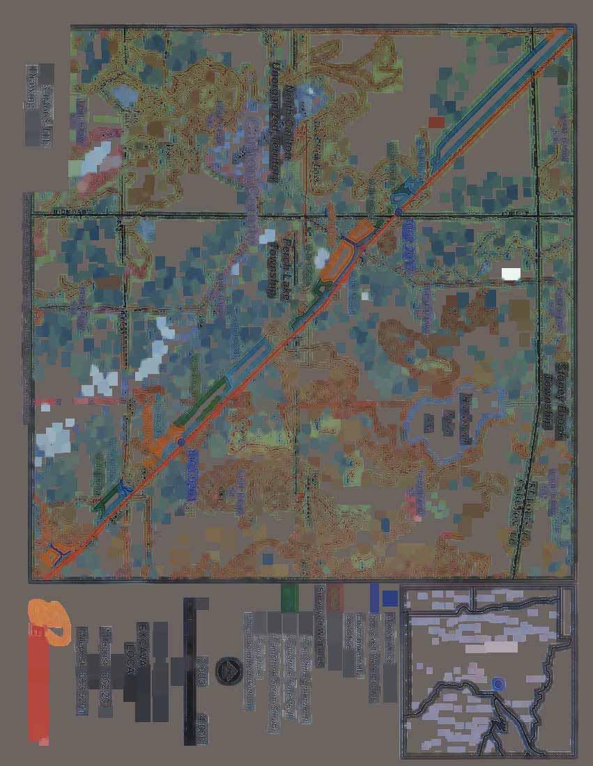
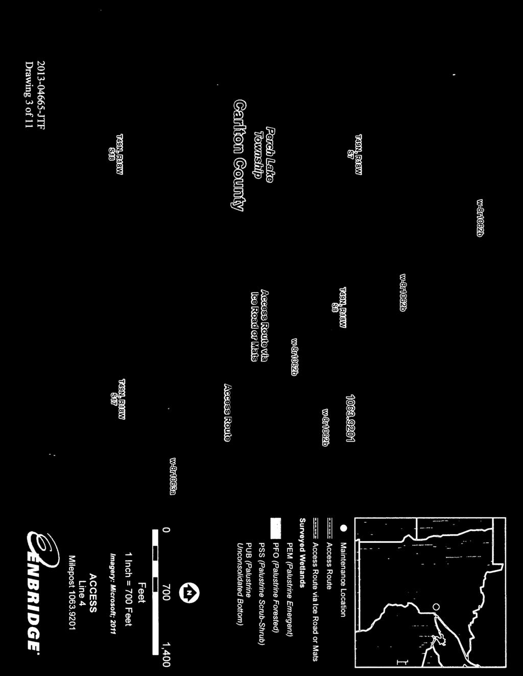
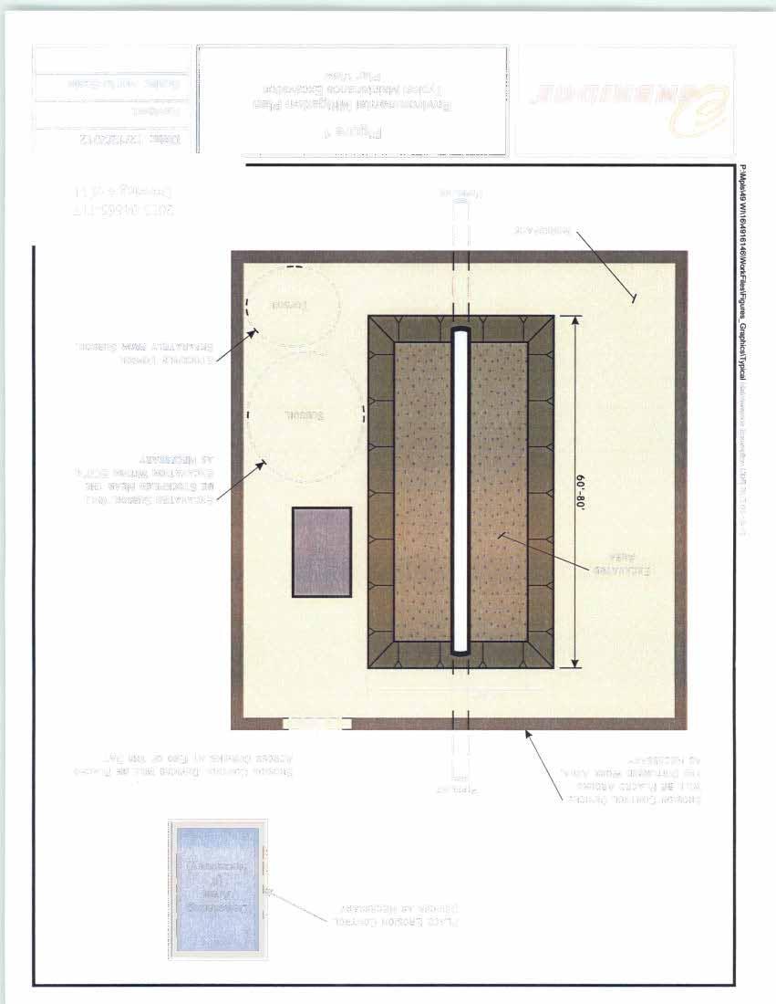
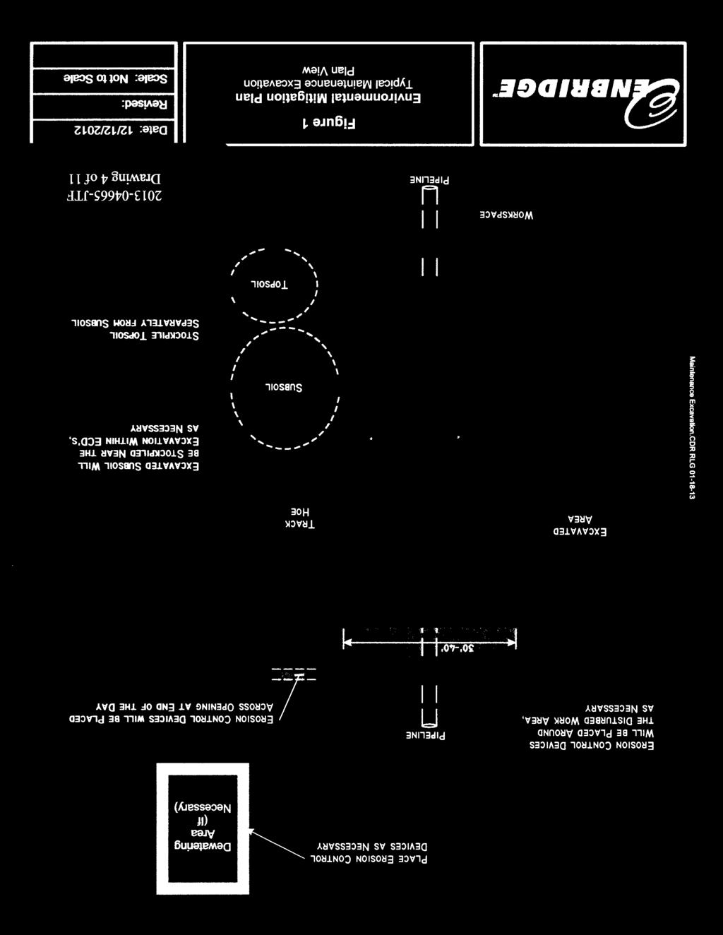
1 Information for File # JTF Applicant Corps Contact Enbridge Energy, Limited Partnership Josh Fitzpatrick Address 1554 Highway 2, Suite 2, Two Harbors, MN joshua.t.fitzpatrick@usace.army.mil Phone (651) Primary County Carlton Sec/Township/Range: SW ¼, Sec. 8, T. 49N., R. 18W.; SE ¼, Sec. 1, T. 49N., R. 19W. Information Complete On January 3, 2014 Posting Expires On January 13, 2014 Authorization Type LOP-10-FDL This application is being reviewed in accordance with the practices for documenting Corps jurisdiction under Sections 9 & 10 of the Rivers and Harbor Act of 1899 and Section 404 of the Clean Water Act identified in Regulatory Guidance Letter We have made a preliminary determination that the aquatic resources that would be impacted by the proposed project are regulated by the Corps of Engineers under Section 404 of the Clean Water Act. Our jurisdictional review and final jurisdictional determination could result in modifications to the scope of the project s regulated waterbody/wetland impacts and compensatory mitigation requirements identified above. An approved jurisdictional determination will be made prior to reaching a permit decision, and will be posted on the St. Paul District web page at PROJECT PURPOSE & NEED: The maintenance work is necessary to inspect and repair anomaly indications identified through Enbridge s pipeline inspection program. The purpose of the project is to inspect, and if necessary, repair sections of Enbridge s pipelines on Line 2 at Milepost (MP) and Line 4 at MP that are adjacent to wetland areas within the boundaries of the Fond du Lac (FdL) Reservation. PROJECT DESCRIPTION: The area around Line 2 and Line 4 would be excavated, visually and physically inspected, and repaired as needed. Each excavation would be approximately 30 to 40 feet wide, 60 to 80 feet long and up to 10 feet deep. The total area of temporary disturbance for each Milepost excavation is estimated to be 0.08 acres. 1
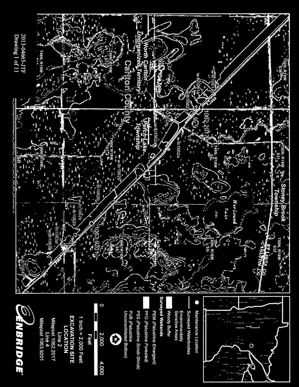
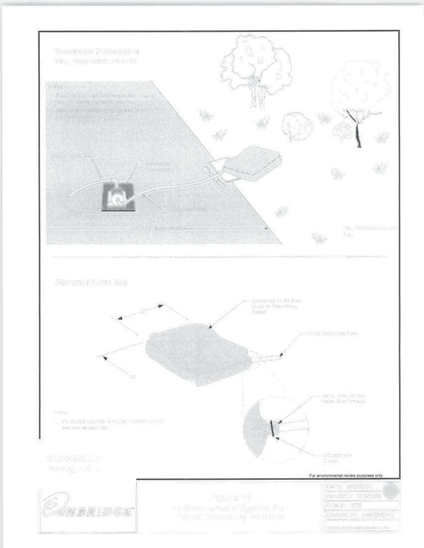
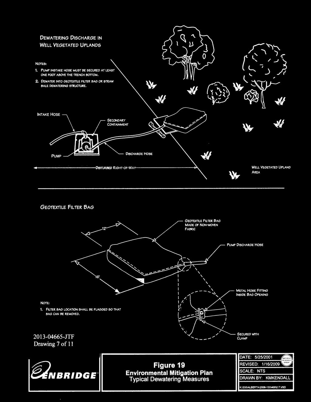
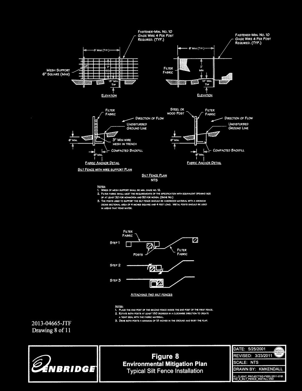
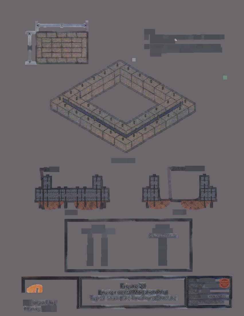
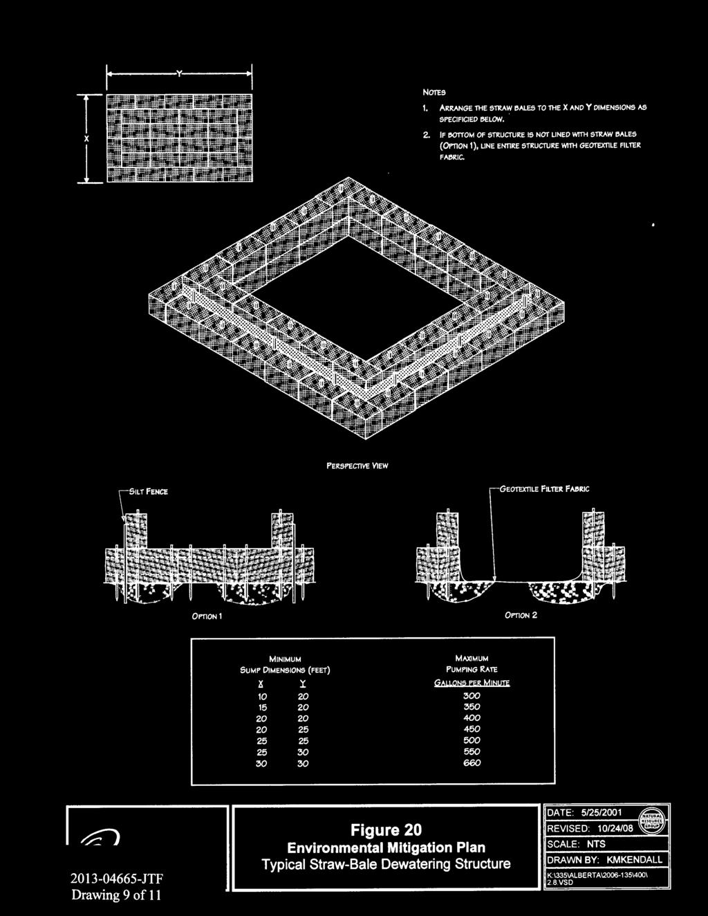
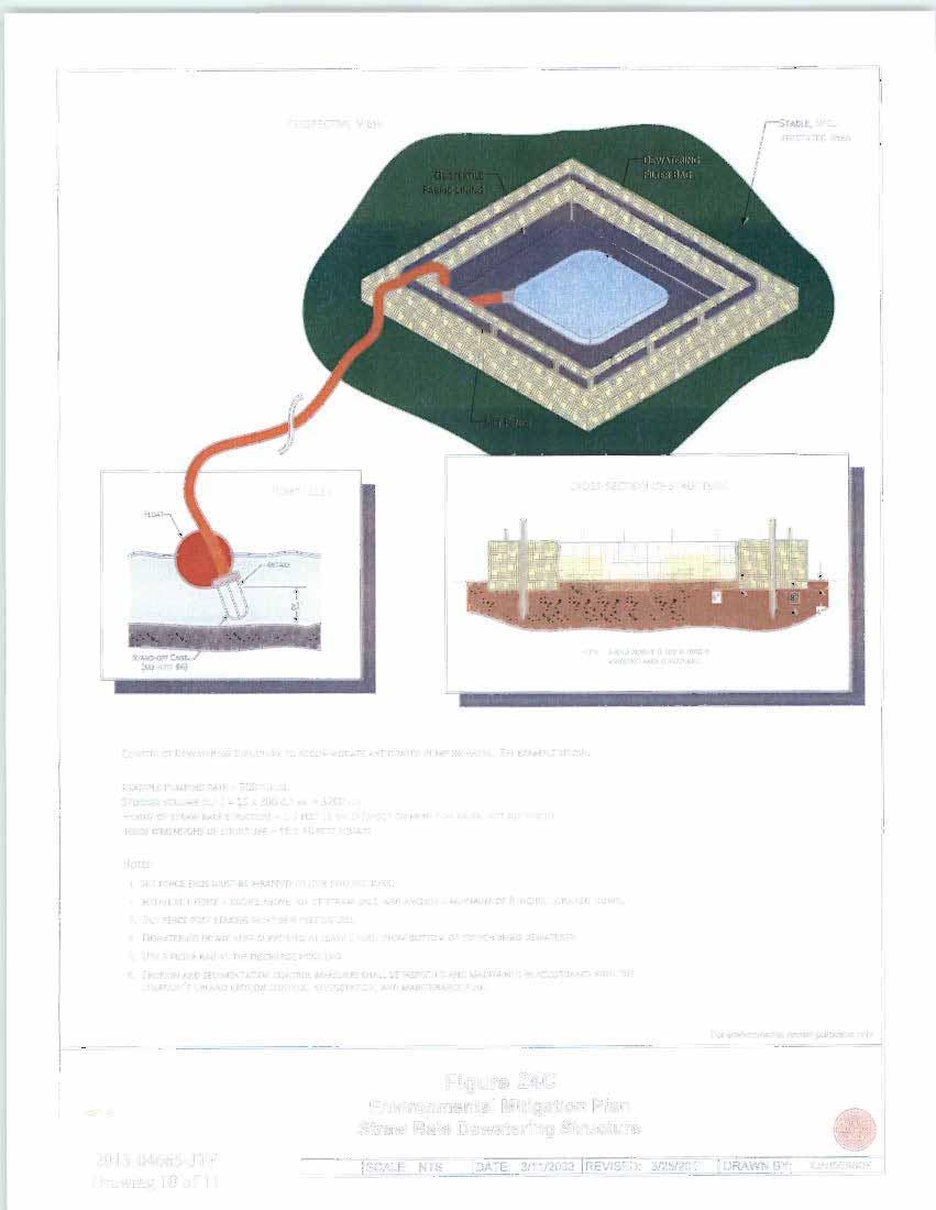
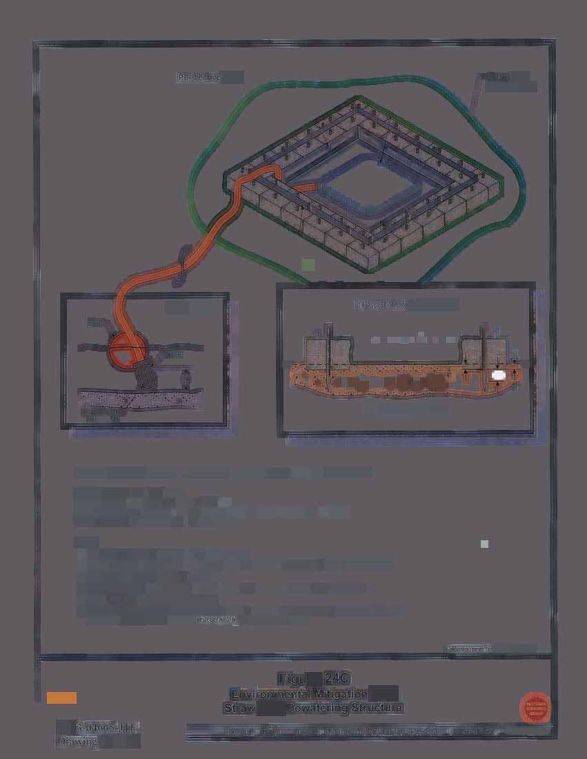
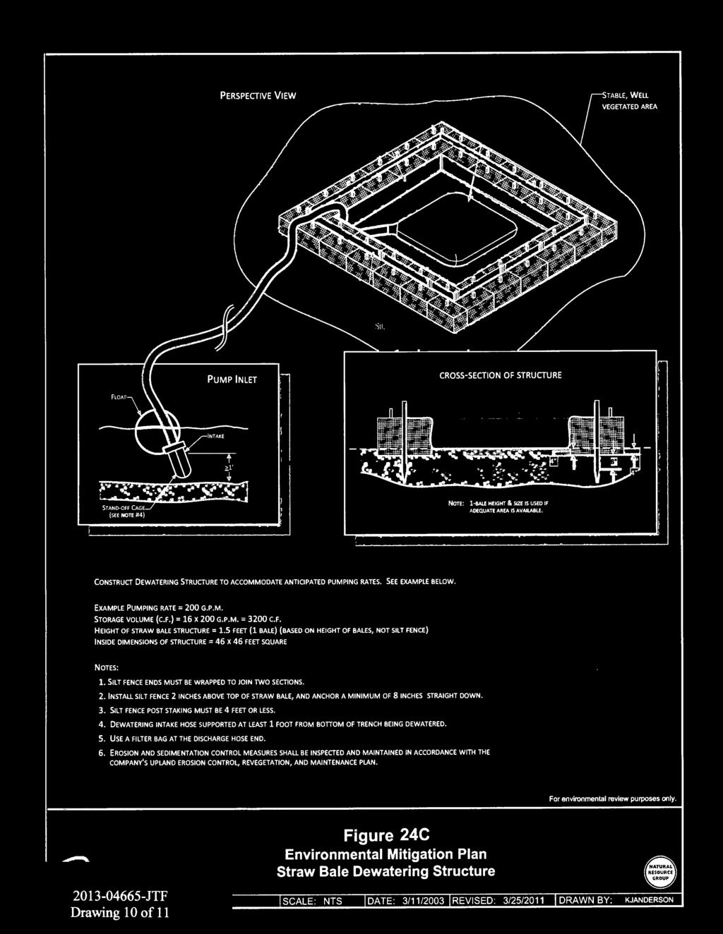
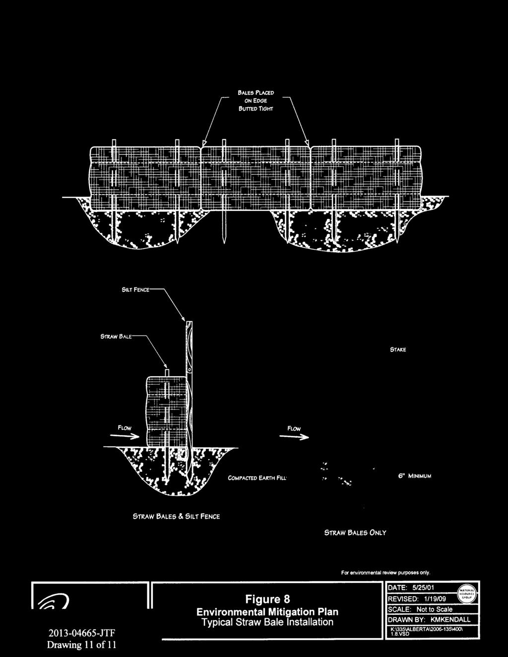
2 Equipment used would include a backhoe or similar excavator, and trucks to transport personnel, equipment and soil. Erosion control measures, such as silt fence and straw bales, would be installed as needed prior to soil disturbance in accordance with Enbridge s Environmental Mitigation Plan. The soil erosion control structures would be maintained by Enbridge personnel. Enbridge may temporarily place rock in the bottom of the excavations to create a safe and dry surface to complete pipeline inspection and repair maintenance work. Within wetlands, Enbridge would install a physical barrier, such as geotextile fabric, below the rock to separate the rock and native soils. The rock and physical barrier would be removed from the excavations prior to backfilling of the excavation. Access to the maintenance location at MP would be from the southeast via Township Road 535, across Stoney Brook via a temporary bridge, proceeding northwest on the existing Enbridge right-of way (ROW) to the maintenance location. A portion of the access route is located in wetland. Timber mats would be used as necessary to prevent compaction and rutting in the wetland areas. Access to the site crosses through wetlands. Enbridge plans to create frost roads to facilitate access through the wetland, as the weather conditions allow, using caution not to disturb any soil in the process of creating and utilizing them. Timber mats would be utilized where necessary to ensure no rutting or mixing of wetland soils occurs. Stoney Brook would be crossed using a temporary clear span bridge with in-stream pier supports installed. To construct the bridge, approximately 5 to 7 temporary piers would be installed within the channel of Stoney Brook to support the bridge decking. The piers would be installed to minimize stream flow restriction. Pier caps, I-beams, and timber mats would be placed across the waterbody and would be constructed to extend beyond the top of bank on each side of the waterbody. The bridge would be designed such that the bridge end supports would extend beyond the immediate top of the bank and not on the sides to avoid streambank impacts. Wooden swamp mat ramps would be used as ramps on the approaches of the bridge. No fill would be used. All efforts would be made to ensure that the stream bank and immediate top of bank are not disturbed during installation, use and removal of the bridge, regardless of the presence of frozen ground conditions. Prior to the installation of the temporary bridge, geotechnical soil borings would be collected. The soil borings would be collected from Township Road 535, adjacent to Stoney Brook. The soil borings are required to determine the depth of pier installation necessary to support the bridge. Enbridge collected the soil borings in December Access to the site would be via a temporary timber mat access route that would extend approximately 1,000 feet across wetland area. Total temporary impacts to wetlands from the access route, excavation, and staging areas is estimated to be 0.86 acre. 2
3 Access to the maintenance location MP at would be from County Road 421/Ditchbank Road onto the Enbridge ROW and proceeding northwest along the ROW to the maintenance location. Access to the site crosses through the wetlands. Enbridge plans to create frost roads to facilitate access through the wetland, as the weather conditions allow, using caution not to disturb any soil in the process of creating and utilizing them. Timber mats would be utilized where necessary to ensure no rutting or mixing of wetland soils occurs. Access to the site would be via a temporary timber mat access route that would extend approximately 1,000 feet across wetland area. Timber mats are approximately 16 feetwide. Total temporary impacts to wetlands from the access route, excavation, and staging areas is estimated to be 0.86 acre. Erosion and sediment control measures would be implemented prior to beginning work at each maintenance location. Equipment encroaching upon wetlands would operate from frost/ice roads and clean timber or construction mats, as necessary to eliminate rutting, soil mixing, and minimize compaction. Enbridge would limit the size of the excavation and amount of work space utilized within wetlands. Upon completion of the work, the sites would be restored and seeded with an approved FDL mix. Installed erosion and sediment control structures would be removed after new growth has been established. Site restoration would begin as soon as soil conditions permit seed bed preparation and seed germination. Enbridge may conduct dormant seeding during frozen conditions, as feasible. Every effort would be made to begin site restoration, including installation of permanent erosion control measures, as soon as practicable. Enbridge anticipates that dewatering activities (using pumps) may be necessary at the maintenance locations. Dewatering discharges would be directed to a filtration sediment bag placed inside a geotextile lined straw bale dewatering structure. The dewatering structure would be located in an upland area near the construction sites, where possible. Final cleanup would begin with removal of all construction-related debris and material which is not an integral part of the pipeline (including litter generated by pipeline crews and excess rock and large woody debris, greater than 1.5 inch diameter and/or 12 inches in length) from the Landowner's property. After clean-up is completed, the disturbed areas shall be graded to restore the contours of the land to previous conditions. After final grading, slopes in areas other than cropland would be stabilized with permanent erosion control structures. Swales across the right-of-way would be restored to original contours wherever practicable. Swales would be seeded and mulched with straw for the width of the ROW. Drainage ditches and intermittent streams would be permanently restored and stabilized with erosion control blanket, permanent seeding, or other appropriate measures. The bridge and in-stream piers would be removed from Stoney Brook without disturbing the waterbody banks, regardless of frozen conditions. 3
4 NAME, AREA AND TYPES OF WATERS (INCLUDING WETLANDS) SUBJECT TO LOSS: The project at Lines 2 and 4 would result in temporary impacts to 1.72 acres of fresh meadow, shrub swamp, and bog wetlands. The sites would be restored upon completion of the project. Site restoration would begin as soon as soil conditions permit seed bed preparation and seed germination. Disturbed areas would be graded to restore the contours of the land to previous conditions. Erosion control structures would be removed after new growth has been established. ALTERNATIVES CONSIDERED: The no-build alternative was dismissed due to failure to act would result in non-compliance with pipeline safety regulations. Safety and liability risk would be compromised by no action as well. The second alternative of excavation of the trench, repair or replace the damaged pipe sections at each of the two different milepost locations, and subsequently backfill and restore saturated, unstable wetlands during the winter months was chosen. This alternative would have the least adverse effect on wetlands because of frost. COMPENSATORY MITIGATION: No permanent wetland impacts would result from the project, thus there would be no required compensatory mitigation. DRAWINGS: See attached. 4

5
6

7
8
9
10
11

12
13
14
15
Information for File # ARC
 Information for File # 2015-02781-ARC Applicant Corps Contact Enbridge Energy, Limited Partnership Andrew R Chambers Address 600 South Lake Avenue, Suite 211, Duluth, MN 55802 E-Mail Andrew.R.Chambers@usace.army.mil
Information for File # ARC
 Information for File # 2016-02630-ARC Applicant Corps Contact Will Bomier-Carlton County Transportation Department Andrew R Chambers Address 600 South Lake Avenue, Suite 211, Duluth, MN 55802 E-Mail Andrew.R.Chambers@usace.army.mil
Information for File MMJ Main Stem Bassett Creek Restoration Project
 Information for File 2013-03866-MMJ Main Stem Bassett Creek Restoration Project Applicant: Minneapolis Park and Recreation Board (MPRB) Corps Contact: Melissa Jenny Address: Corps of Engineers, St. Paul
Information for File # SEK
 Information for File # Applicant: Dane County Corps Contact: Simone Kolb Address: 20711 Watertown Rd., Suite F, Waukesha, WI, 53186 E-Mail: simone.e.kolb@usace.army.mil Phone: 262-717-9539 Primary County:
Urban Conservation Practice Physical Effects ESTABLISHMENT, GROWTH, AND HARVEST NUTRIENT MANAGEMENT
 NOT WELL 800 - Urban Stormwater Wetlands A constructed system of shallow pools that create growing conditions for wetland plants to lessen the impacts of stormwater quality and quantity in urban areas.
MARBLE RIVER WIND POWER PROJECT Agricultural Protection Measures
 MARBLE RIVER WIND POWER PROJECT Siting Considerations 1. Locate access roads and, to the extent allowed by local laws, wetlands and topography, individual wind turbines and other structures along field
Methods, approaches, and procedures to minimize active agricultural land impacts during pipeline construction, surface restoration, and pipeline
 Agricultural Impact Minimization Plan Methods, approaches, and procedures to minimize active agricultural land impacts during pipeline construction, surface restoration, and pipeline operation. PennEast
UPLAND EROSION CONTROL, REVEGETATION, AND MAINTENANCE PLAN
 UPLAND EROSION CONTROL, REVEGETATION, AND MAINTENANCE PLAN 01/17/2003 VERSION UPLAND EROSION CONTROL, REVEGETATION, AND MAINTENANCE PLAN TABLE OF CONTENTS I. APPLICABILITY... 1 II. SUPERVISION AND INSPECTION...
City of Stoughton Erosion Control Permit Application (effective 2/6/2018)
") City of Stoughton Erosion Control Permit Application (effective 2/6/2018) Incomplete applications will not be accepted Project Name: Address of subject property: Landowner Name(s): Applicant Name: Landowner
City of Stoughton Erosion Control Permit Application (effective 2/6/2018) Incomplete applications will not be accepted Project Name: Address of subject property: Landowner Name(s): Applicant Name: Landowner
EROSION & SEDIMENT CONTROL
 EROSION & SEDIMENT CONTROL Surface Water Protection During Well Site Construction Kelly Kees, PE WVDEP, Office of Oil and Gas SEDIMENT & EROSION CONTROL PLANS Per West Virginia State Code 22-6-6(d) 22-6A-7(c),
SECTION 6. Routine Maintenance Activity Details
 SECTION 6 Routine Maintenance Activity Details 80. DEBRIS REMOVAL When Deadfall, and other objects, such as shopping carts, tires, appliances, and mattresses have accumulated in the drain. Why To prevent
Information for File # MVP MMJ; Elim Care
 Information for File # MVP-217-2628-MMJ; Elim Care Applicant: Elim Care of Maple Plain Corps Contact: Melissa Jenny Address: 18 Fifth Street East, Suite 7, St. Paul, MN 5511-168 E-Mail: Melissa.m.jenny@usace.army.mil
FEDERAL ENERGY REGULATORY COMMISSION FIELD INSPECTION REPORT
 FIELD INSPECTION REPORT Date September 19, 2018 Project Northern Natural Gas Company (Northern) Cedar Station Upgrade Project Dakota County, Minnesota Authority: Section 7(c) Personnel FERC Staff: Company
Erosion Control for Home Builders in the. City of Jacksonville
 Erosion Control for Home Builders in the City of Jacksonville Eroding construction sites are a leading cause of water quality problems in Jacksonville. For every acre under construction, about a dump truck
Methods, approaches, and procedures to minimize active agricultural land impacts during pipeline construction, surface restoration, and pipeline
 Agricultural Impact Minimization Plan Methods, approaches, and procedures to minimize active agricultural land impacts during pipeline construction, surface restoration, and pipeline operation. PennEast
Soil Reclamation and Site Reinstatement
 APPENDIX 6 Soil Reclamation and Site Reinstatement Purpose To undertake soil reclamation, erosion protection, Site restoration and reinstatement, taking into account natural processes, operational requirements
M-231 and Water Quality. Ottawa County Water Quality Forum November 21, 2016 James Fortney, MDOT
 M-231 and Water Quality Ottawa County Water Quality Forum November 21, 2016 James Fortney, MDOT M-231 Facts: 7-Miles long 2-Lane Limited Access Highway Connects I-96 and M-45 M-231 Facts: Includes Michigan
CHAPTER 4. SPECIAL CONDITION EROSION CONTROL MEASURES
 CHAPTER 4. SPECIAL CONDITION EROSION CONTROL MEASURES 4.1 INFILTRATION BASIN AND TRENCH Figure 4.1. Infiltration basin and trench (Source: Department of Civil, Construction, and Environmental Engineering,
ENBRIDGE GAS DISTRIBUTION INC. Proposed Relocation for Ninth Line, Markham and Whitchurch-Stouffville. Environmental Screening Report
 Page 1 of 18 ENBRIDGE GAS DISTRIBUTION INC. Proposed Relocation for Ninth Line, Markham and Whitchurch-Stouffville Environmental Screening Report July 2011 Page 2 of 18 Table of Contents 1.0 INTRODUCTION
Information for File MVP MMJ; CSAH 10 Reconstruction (Waconia and Watertown Townships)
") Information for File MVP-2014-03830-MMJ; Reconstruction (Waconia and Watertown Townships) Applicant: Carver County Corps Contact: Melissa Jenny Address: 180 Fifth Street East, Suite 700, St. Paul, MN 55101
Information for File MVP-2014-03830-MMJ; Reconstruction (Waconia and Watertown Townships) Applicant: Carver County Corps Contact: Melissa Jenny Address: 180 Fifth Street East, Suite 700, St. Paul, MN 55101
Alternative Names: Erosion Control Matting, Erosion Control Netting, Rolled Erosion Control Products (RECP)
") 4.5-s EROSION CONTROL BLANKET SYSTEM Alternative Names: Erosion Control Matting, Erosion Control Netting, Rolled Erosion Control Products (RECP) DESCRIPTION Erosion control blanket systems are woven or
4.5-s EROSION CONTROL BLANKET SYSTEM Alternative Names: Erosion Control Matting, Erosion Control Netting, Rolled Erosion Control Products (RECP) DESCRIPTION Erosion control blanket systems are woven or
Illinois Urban Manual
 Illinois Urban Manual Jim Nelson: Association of Illinois Soil and Water Conservation Districts (AISWCD) Funding for this project provided, in part, by the Grand Victoria Foundation of Elgin IL, the Governor
STREAM ALTERATION PRACTICES
 STREAM ALTERATION PRACTICES Stream Diversion Channel SDC DEFINITION A temporary channel constructed to convey stream flow around in-stream construction. PURPOSE Stream diversion channels are used to allow
Information for File # ARC
 Information for File # 2017-03115-ARC Applicant Consultant Corps Contact Bob Manzoline St. Louis and Lake Counties Regional Rail Authority Natalie White Short Elliot Hendrickson (SEH) Inc. Andrew R Chambers
Plan of Development Mountain Valley Pipeline Project. APPENDIX M Winter Construction Plan
 APPENDIX M October 20, 2017 Appendix M Prepared by: October 20, 2017 TABLE OF CONTENTS 1.0 INTRODUCTION... M-1 2.0 STABILIZATION/WINTERIZATION... M-2 3.0 EROSION AND SEDIMENT CONTROL MEASURES... M-3 4.0
King and Queen County Department of Building & Zoning P.O. Box 177, King and Queen Courthouse, VA Phone: Fax:
 King and Queen County Department of Building & Zoning P.O. Box 177, King and Queen Courthouse, VA 23085 Phone: 804-785-5975 Fax: 804-769-5000 Water Quality Impact Assessment (WQIA) Application Note: Encroachment
CITY OF TUMWATER 555 ISRAEL RD. SW, TUMWATER, WA (360) (360) (FAX)
 (360) (FAX)") CITY OF TUMWATER 555 ISRAEL RD. SW, TUMWATER, WA 98501 (360) 754-4180 (360) 754-4126 (FAX) Email: cdd@ci.tumwater.wa.us APPENDIX II-C SHORT FORM CONSTRUCTION STORMWATER POLLUTION PREVENTION PLAN (SWPPP)
CITY OF TUMWATER 555 ISRAEL RD. SW, TUMWATER, WA 98501 (360) 754-4180 (360) 754-4126 (FAX) Email: cdd@ci.tumwater.wa.us APPENDIX II-C SHORT FORM CONSTRUCTION STORMWATER POLLUTION PREVENTION PLAN (SWPPP)
Department of Agriculture. Conservation Service. United States. Natural Resources REVISED 8/26/16
 GENERAL NOTES: SYMBOL LEGEND 1. All work shall comply with the constriction specifications, drawings, project-specific quality assurance plan and other contract requirements. 2. All notes on the drawings
FEDERAL ENERGY REGULATORY COMMISSION FIELD INSPECTION REPORT
 FEDERAL ENERGY REGULATORY COMMISSION FIELD INSPECTION REPORT Date June 20, 2018 Project Northern Natural Gas Company Northern Lights 2017 Expansion Project Rice, Sherburne, and Isanti Counties, Minnesota
SOIL EROSION AND SEDIMENT CONTROL
 SOIL EROSION AND SEDIMENT CONTROL SECTION 1: AUTHORITY, TITLE AND PURPOSE 11. STATUTORY AUTHORIZATION This ordinance is adopted pursuant to the provisions of the Federal Water Pollution Control Act 86
EROSION & SEDIMENT CONTROL
 EROSION & SEDIMENT CONTROL 1 EROSION & SEDIMENT CONTROL Effective Soil & Water Protection Whether you want to prevent soil erosion caused by rain, water and wind, or protect waterways from inevitable build
ATTACHMENT 1 WILSON MINE LECROY AREA SEMIPERMANENT DEWATERING SYSTEM
 ATTACHMENT 1 WILSON MINE LECROY AREA SEMIPERMANENT DEWATERING SYSTEM Reclamation plans for the Wilson Mine Lecroy area were approved by the Arkansas Department of Environmental Quality with a passive barrier
/s/ Michael T. Loeffler. Michael T. Loeffler Senior Director, Certificates and External Affairs. Attachment. September 14, 2018.
 Northern Natural Gas Company P.O. Box 3330 Omaha, NE 68103-0330 402 398-7200 September 14, 2018 Via efiling Ms. Kimberly D. Bose, Secretary Federal Energy Regulatory Commission 888 First Street, N.E. Washington,
STANDARD SPECIFICATIONS SECTION TEMPORARY EROSION AND SEDIMENT CONTROL
 STANDARD SPECIFICATIONS SECTION 01570 TEMPORARY EROSION AND SEDIMENT CONTROL PART 1 GENERAL 1.1 DESCRIPTION A. Section includes requirements, procedures, and methods related to responsibilities for providing
Town of Essex Small Site Erosion Control Guide
 Town of Essex Small Site Erosion Control Guide Why do we need to protect against erosion? Water Quality: Erosion and the transport of sediment and pollutants impacts the water quality of nearby streams
Stormwater Standards. Clackamas County Service District No. 1. Planting Guide for Buffers
 Stormwater Standards Clackamas County Service District No. 1 APPENDIX B Planting Guide for Buffers Table of Contents Appendix B - Planting Guide for Buffers... Page B.1 General... 1 B.1.1 Introduction...
The Low Risk Site Handbook
 The Low Risk Site Handbook for Erosion Prevention and Sediment Control The content of this Handbook is adapted from the New York State Standards and Specifications for Erosion and Sediment Control-August
Drainage Analysis-Newgate/Phelps & Hatchett Hill Road Areas Rev. 0 Erosion & Sediment Control Measures
 Drainage Analysis-Newgate/Phelps & Hatchett Hill Road Areas Rev. 0 Erosion & Sediment Control Measures 4.0 EROSION & SEDIMENT CONTROL MEASURES After performing the analysis summarized above, Burns & McDonnell
VEGETATED SLOPE STABILIZATION DESCRIPTION APPLICABILITY. Advantages
 4.2-d VEGETATED SLOPE STABILIZATION Alternative Names: Willow Wattles, Live Bundles, Fascines, Live Staking, Joint Planting, Branch Packing, Brush Layering, and Brush Matting DESCRIPTION Vegetated slope
Shelbyville, KY Stormwater Best Management Practices. Section 2 EROSION PREVENTION AND SEDIMENT CONTROL PLAN
 Section 2 EROSION PREVENTION AND SEDIMENT CONTROL PLAN 2.1 Requirements The City of Shelbyville, KY will require an Erosion Prevention and Sediment Control (EPSC) Plan for most types of development construction.
PROPOSED DRAINAGE PATTERNS
 1121 1118.50 Basin Floor 1120 1119 0 N 100 200 PROPOSED DRAINAGE PATTERNS Deroiser Drive Riverwood Drive County 260 0 100 200 Project Name: Riverwood Drive LITTLE FALLS TOWNHOMES Project Location: LITTLE
Wisconsin Contractors Institute Continuing Education
 Wisconsin Contractors Institute Continuing Education Erosion & Sediment Control Course # 12775 2 hours Wisconsin Contractors Institute N27 W23953 Paul Road, Suite 203 Pewaukee, WI 53072 Website: www.wicontractorsinstitute.com
Florence County Small Commercial Land Disturbance Permit Application
 Florence County Small Commercial Land Disturbance Permit Application Florence County Engineering Division 518 South Irby Street Florence, S.C. 29501 Phone (843) 676-8600 Fax (843) 676-8667 Tax Map Number:
A. Install all temporary erosion control measures (in accordance with MNDOT General Conditions 2573) prior to site disturbance.
 prior to site disturbance.") The language provided in these specifications is meant to serve as a reminder and provide a generic example of the type of language that should be provided in final construction documents. This language
The language provided in these specifications is meant to serve as a reminder and provide a generic example of the type of language that should be provided in final construction documents. This language
MANUAL OF DESIGN, INSTALLATION, AND MAINTENANCE REQUIREMENTS FOR STORMWATER MANAGEMENT PLANS
 MANUAL OF DESIGN, INSTALLATION, AND MAINTENANCE REQUIREMENTS FOR STORMWATER MANAGEMENT PLANS May 2007 SECTION 1 Responsibility of Applicant TABLE OF CONTENTS A. Stormwater Management Plan Required Information
Chagrin River Watershed Partners, Inc. Local Regulations. Amy H. Brennan (440)
") Chagrin River Watershed Partners, Inc. Local Regulations Amy H. Brennan (440) 975-3870 www.crwp.org abrennan@crwp.org July 9, 2013 Applicable Zoning and Building Codes Erosion and Sediment Control Grading
Chagrin River Watershed Partners, Inc. Local Regulations Amy H. Brennan (440) 975-3870 www.crwp.org abrennan@crwp.org July 9, 2013 Applicable Zoning and Building Codes Erosion and Sediment Control Grading
Information for File # MMJ; Methodist Hospital Flood Storage Mitigation and Wetland Enhancement Project
 Information for File # 2016-01223-MMJ; Methodist Hospital Flood Storage Mitigation and Wetland Enhancement Project Applicant: Park Nicollet, Attn: Robert Riesselman Corps Contact: Melissa Jenny Address:
FEDERAL ENERGY REGULATORY COMMISSION WASHINGTON, D.C
 FEDERAL ENERGY REGULATORY COMMISSION WASHINGTON, D.C. 20426 OFFICE OF ENERGY PROJECTS August 10, 2018 In Reply Refer To: OEP/DG2E/Gas Branch 3 Mountain Valley Pipeline LLC CP16-10-000 Matthew Eggerding,
POST-FIRE RESTORATION Dos and Don ts
 POST-FIRE RESTORATION Dos and Don ts USDA Natural Resources Conservation Service The NRCS/RCD office is located at: 744 LA GUARDIA ST BLDG A SALINAS, CA 93905-3354 (831) 424-1036 (NRCS) (831) 424-1036
SUPPORTING DOCUMENT STORMWATER POLLUTION PREVENTION PLAN (SWPPP) NARRATIVE
 NARRATIVE") SUPPORTING DOCUMENT STORMWATER POLLUTION PREVENTION PLAN (SWPPP) NARRATIVE Please complete this narrative form and submit with your SWPPP drawings. Refer to Kitsap County Stormwater Design Manual Vol.
SUPPORTING DOCUMENT STORMWATER POLLUTION PREVENTION PLAN (SWPPP) NARRATIVE Please complete this narrative form and submit with your SWPPP drawings. Refer to Kitsap County Stormwater Design Manual Vol.
Information for File # MMW
 Information for File #07-0870-MMW Applicant: Menards (Tyler Edwards) Corps Contact: Mariah Weitzenkamp Address: 80 Fifth Street East, Suite 700, Saint Paul, MN 0-78 E-Mail: Mariah.M.Weitzenkamp@usace.army.mil
EnkaTech Note. Installation Guide for Enkamat Slopes and Channels. Site Preparation. Anchor Trench. Enkamat Installation
 EnkaTech Note Installation Guide for Enkamat Slopes and Channels Site Preparation For both slope and channel applications, the site must be shaped to the design specifications (grade, geometry, soil compaction,
PERMANENT SEEDING. Overview of Sedimentation and Erosion Control Practices. Practice no. 6.11
 Overview of Sedimentation and Erosion Control Practices Practice no. 6.11 PERMANENT SEEDING Permanent vegetation controls erosion by physically protecting a bare soil surface from raindrop impact, flowing
Site Formation Excavation - 6' depth square yard $8.00 $0.00 Grading square yard $1.50 $0.00 Hauling off-site - 6' depth square yard $10.00 $0.
 SURFACE SAND FILTER COST ESTIMATE WORKSHEET 2005 Prices Project Title Owner Location Project Number Date Description Units Quantity Unit Cost Total Estimated Price Site Preparation Tree removal - up to
Understanding Drainage Options What s Feasible and Legal. February 2019
 Understanding Drainage Options What s Feasible and Legal February 2019 Outline for the Presentation Do you need a permit? Does common law apply? Does local government approve it? Will my neighbor allow
Information for File # RMM
 Information for File #2015-00067-RMM Applicant: New Ulm Public Schools Corps Contact: Ryan Malterud Address: 180 Fifth Street East, Suite 700, St. Paul, Minnesota 55101-1678 E-Mail: ryan.m.malterud@usace.army.mil
Information for File # MVP MMJ
 Information for File # MVP-218-477-MMJ Applicant: City of Rogers Corps Contact: Melissa Jenny Address: 18 Fifth Street East, Suite 7, St. Paul, MN 5511-1648 E-Mail: Melissa.m.jenny@usace.army.mil Phone:
Table 4.7.1: Swales Potential Application and Storm Water Regulation
 4.7. Swales A swale is a vegetated open channel, planted with a combination of grasses and other herbaceous plants, shrubs, or trees. A traditional swale reduces peak flow at the discharge point by increasing
Key elements : Filter Strips must be designed within parameters required by the Fort Wayne s Development Standards/Criteria Manual.
 4.4. Filter Strips Filter Strips are densely vegetated lands that treat sheet flow storm water from adjacent pervious and impervious areas. They function by slowing runoff, trapping sediment and pollutants,
 3" TO 4" OF TOPSOIL 2:1 MIRAFI HP 565 GEO FABRIC OR EQUIVALENT 9' SPILLWAY EL=7147 2:1 SPILLWAY SECTION N.T.S. TOP OF POND EL=7149' RIP-RAP D 50 8" WRAPPED IN FILTER FABRIC 45 MIL HDPE POND LINER OR EQUIVALENT
STREAM BANK STABILIZATION THORPS MORTIMER RECREATION AREA Grandfather Ranger District SITE LOCATION & DRAINAGE AREA
 STREAM BANK STABILIZATION THORPS CREEK @ MORTIMER RECREATION AREA SITE LOCATION & DRAINAGE AREA SITE LOCATION Drainage Area = 1.14 sq. miles STREAM BANK STABILIZATION THORPS CREEK @ MORTIMER RECREATION
Monica Smith, PE President Robinson Engineering Company
 Monica Smith, PE President Robinson Engineering Company Owner Robinson Engineering Masters Degree in Water Resource Management for Colorado State University The Dry Run Creek project got me interested
General Information. Site Conditions. 9b 9b. 9a 1b. Best Management Practices Illustration
 Model Construction SWPPP Planning & Development Services 1800 Continental Place Mount Vernon WA 98273 voice 360-416-1320 inspections 360-416-1330 www.skagitcounty.net/stormwaterpermitting Permit #: General
WATER QUALITY IMPACT ASSESSMENT (WQIA) FORM
 FORM") WATER QUALITY IMPACT ASSESSMENT (WQIA) FORM Name: CCW Development Associates, L.L.C. Street Address: Telephone Number(s): 1209 Laskin Road, Virginia Beach, VA 23451 (757) 491-1996 Email: chris@vbhomesliving.com
WATER QUALITY IMPACT ASSESSMENT (WQIA) FORM Name: CCW Development Associates, L.L.C. Street Address: Telephone Number(s): 1209 Laskin Road, Virginia Beach, VA 23451 (757) 491-1996 Email: chris@vbhomesliving.com
Piles, inverters, trenching, cabling, assembly.
 Agricultural Inspection Report General Information Project Name Montrose Date of Inspection 11/9/2016 Start/End Time 7:00 am Inspector s Name(s) Inspector s Title(s) Describe present phase of construction
Using the Updated RI Soil Erosion and Sediment Control Handbook. The Introductory Workshop for RIDEM/CRMC Staff January 23, 2015
 Using the Updated RI Soil Erosion and Sediment Control Handbook The Introductory Workshop for RIDEM/CRMC Staff January 23, 2015 URI Cooperative Extension NEMO URI Cooperative Extension NEMO White Oak,
Piles, Trenching, Inverters, Cables, Material Deliveries
 Agricultural Inspection Report General Information Project Name Albany Date of Inspection 20161012 Start/End Time 7:50 am Inspector s Name(s) Inspector s Title(s) Describe present phase of construction
RAIN GARDEN ILLINOIS URBAN MANUAL PRACTICE STANDARD. (feet) CODE 897 DEFINITION
 CODE 897 DEFINITION") ILLINOIS URBAN MANUAL PRACTICE STANDARD RAIN GARDEN (feet) CODE 897 Source: Kendall County Soil and Water Conservation District DEFINITION Rain gardens are small, shallow, flat bottomed depressions constructed
ILLINOIS URBAN MANUAL PRACTICE STANDARD RAIN GARDEN (feet) CODE 897 Source: Kendall County Soil and Water Conservation District DEFINITION Rain gardens are small, shallow, flat bottomed depressions constructed
Urban Planning and Land Use
 Urban Planning and Land Use 701 North 7 th Street, Room 423 Phone: (913) 573-5750 Kansas City, Kansas 66101 Fax: (913) 573-5796 Email: planninginfo@wycokck.org www.wycokck.org/planning To: From: City Planning
Worksheet #14 Water Runoff Management
 Water Runoff Management Use this worksheet to assess how well your property minimizes the potential for water runoff and property damage.. Why should you be concerned? What can you do? Rural runoff, also
Washtenaw County Conservation District 7203 Jackson Rd Ann Arbor MI Phone: (734) x 5 Fax: (734) Web:
 x 5 Fax: (734) Web:") Washtenaw County Conservation District 7203 Jackson Rd Ann Arbor MI 48103-9506 Phone: (734) 761-6721 x 5 Fax: (734) 662-1686 Web: www.washtenawcd.org STEPS IN BUILDING A POND The following list has been
Washtenaw County Conservation District 7203 Jackson Rd Ann Arbor MI 48103-9506 Phone: (734) 761-6721 x 5 Fax: (734) 662-1686 Web: www.washtenawcd.org STEPS IN BUILDING A POND The following list has been
A. Install all temporary erosion control measures (in accordance with MNDOT General Conditions 2573) prior to site disturbance.
 prior to site disturbance.") The language provided in these specifications is meant to serve as a reminder and provide a generic example of the type of language that should be provided in final construction documents. This language
The language provided in these specifications is meant to serve as a reminder and provide a generic example of the type of language that should be provided in final construction documents. This language
Guidance on Preparation of Construction and Maintenance Costs
 INVER GROVE HEIGHTS Northwest Area Appendix F Guidance on Preparation of Construction and Maintenance Costs Northwest Area (NWA) Inver Grove Heights Stormwater Manual Guidance on Preparation of Construction
Zoning Ordinance Article 3
 Article 3 Natural Resources Protection Section 301 Natural Resources Protection 301.1. Purpose - The following natural resources protection standards are established to protect the public health, safety
Chapter 11 Site Rehabilitation and Stabilization
 Chapter 11 Site Rehabilitation and Stabilization Chapter 11 Layout: Part 1 - Page 131 Planning Site Rehab Part 2 - Page 132 Controlling Runoff and Capturing Sediment Part 3 - Page 133 Rehab for Crossings
NOTICE OF INTENT. Submitted To: Bremo Power Station 1038 Bremo Bluff Road Bremo Bluff, VA 23022
 NOTICE OF INTENT TO CLOSE INACTIVE CCR SURFACE IMPOUNDMENTS NOTICE OF INTENT Bremo Power Station Submitted To: Bremo Power Station 1038 Bremo Bluff Road Bremo Bluff, VA 23022 Submitted By: Golder Associates
Information for File #MVP MVM
 Information for File #MVP-2004-02804-MVM Applicant: St. Michael MF, LLC Corps Contact: Marissa Merriman Address: 180 Fifth Street East, Suite 700, St. Paul, Minnesota 55101-1678 E-Mail: Marissa.V.Merriman@usace.army.mil
STREAM BUFFER PROTECTION AND MANAGEMENT
 ORDINANCE NO. 753 AN ORDINANCE AMENDING THE CODE OF ORDINANCES OF THE CITY OF PLEASANT HILL, IOWA 1998, BY ESTABLISHIING CHAPTER 104, STREAM BUFFER PROTECTION AND MANAGEMENT Be it enacted by the City of
A. Contractor shall provide product data for each type of product indicated.
 31 13 00 SELECTIVE TREE AND SHRUB REMOVAL AND TRIMMING SECTION 1 GENERAL 1.1 SUMMARY A. This section includes general protection and pruning of existing trees and plants that are affected by execution
Structural Storm Water Best Management Practices (BMPs)
") Structural Storm Water Best Management Practices (BMPs) Storm Water Permitting: The SWPPP Revealed By Deron Austin, PE January 11, 2006 3:30-5:00 PM Orlando, Florida Presentation Outline Preface About
Structural Storm Water Best Management Practices (BMPs) Storm Water Permitting: The SWPPP Revealed By Deron Austin, PE January 11, 2006 3:30-5:00 PM Orlando, Florida Presentation Outline Preface About
12/7/2007. Christopher B. Burke Engineering West, Ltd Aux Sable Creek Watershed Plan Update 1
 The ABC s of BMP s Aux Sable Watershed Plan St. Charles, IL Why are BMP s Important Best Management Practices (BMPs) developed as a set of practices which help to achieve goals of the Clean Water Act and
Stream Restoration: Working with Nature?
 Stream Restoration: Working with Nature? Greg Jennings, PhD, PE jenningsenv@gmail.com Ecosystem Restoration activities that initiate or accelerate the recovery of ecosystem health, integrity, and sustainability
Stream Restoration: Working with Nature? Greg Jennings, PhD, PE
 Stream Restoration: Working with Nature? Greg Jennings, PhD, PE jenningsenv@gmail.com Ecosystem Restoration activities that initiate or accelerate the recovery of ecosystem health, integrity, and sustainability
Guidelines for Streambank Protection
 PDHonline Course C187 (3 PDH) Guidelines for Streambank Protection Instructor: John Poullain, PE 2012 PDH Online PDH Center 5272 Meadow Estates Drive Fairfax, VA 22030-6658 Phone & Fax: 703-988-0088 www.pdhonline.org
Bowling Green, Kentucky Stormwater Best Management Practices (BMPs) Erosion Prevention Practices (EPPs) Activity: Nets and Mats (N and M)
 Erosion Prevention Practices (EPPs) Activity: Nets and Mats (N and M)") Bowling Green, Kentucky Stormwater Best Management Practices (BMPs) Erosion Prevention Practices (EPPs) Activity: Nets and Mats (N and M) EPP-11 PLANNING CONSIDERATIONS: Design Life: 1 yr Acreage Needed:
Bowling Green, Kentucky Stormwater Best Management Practices (BMPs) Erosion Prevention Practices (EPPs) Activity: Nets and Mats (N and M) EPP-11 PLANNING CONSIDERATIONS: Design Life: 1 yr Acreage Needed:
Preventing Storm Water Pollution: What We Can Do
 Preventing Storm Water Pollution: What We Can Do ~Employee Training Series~ Land Disturbances PREPARED IN COOPERATION WITH THE Texas Commission on Environmental Quality AND U.S. ENVIRONMENTAL PROTECTION
EROSION PREVENTION BMP SUGGESTED USES MATRIX
 EROSION PREVENTION SUGGESTED USES MATRIX Processed Based Tools Software Aids Slope Waterway Surface Concentrated Flows Large Flat Stock Pile Borrow Adjacent Property Impacts Erosion Prevention Measures
RECOMMENDED BEST MANAGEMENT PRACTICES FOR RESTORATION OF WETLANDS AFTER TEMPORARY IMPACTS
 RECOMMENDED BEST MANAGEMENT PRACTICES FOR RESTORATION OF WETLANDS AFTER TEMPORARY IMPACTS Prepared in partial fulfillment of a U.S. Environmental Protection Agency State Wetland Program Development Grant
CHAPTER 102 REQUIREMENTS CRITCAL STAGES DURING CONSTRUCTION ACTIVITIES
 CHAPTER 102 REQUIREMENTS CRITCAL STAGES DURING CONSTRUCTION ACTIVITIES TOPICS Steps Prior to construction Pre-Construction Meeting Defining the Critical Stages with the Contractor Brady s Run Lake Site
Rule D Wetland and Creek Buffers
 Rule D Wetland and Creek Buffers 1 Policy It is the policy of the Board of Managers to ensure the preservation of the natural resources, recreational, habitat, water treatment and water storage functions
Analyzing the Bioretention Construction Sequence
 Analyzing the Bioretention Construction Sequence Avoiding future problems through careful installation procedures, construction inspection and first year maintenance 20 Steps to Better Bioretention Step
Project Applicant Checklist for NPDES Permit Requirements SAN MATEO COUNTYWIDE STORMWATER POLLUTION PREVENTION PROGRAM
 Project Applicant Checklist for NPDES Permit Requirements SAN MATEO COUNTYWIDE STORMWATER POLLUTION PREVENTION PROGRAM I. PROJECT DATA Project Name Bay Meadows Development Phase II Project Address 2600
Information for File # MHK
 Information for File #2014-03555-MHK Applicant: Corps Contact: Wimmer Communities Marie Kopka Address: 250 N. Sunnyslope Road, Suite 296 Brookfield, Wisconsin 53005 E-Mail: Marie.H.Kopka@usace.army.mil
East Coast Erosion Blankets
 Protect Your Landscapes with East Coast Erosion Blankets Soil erosion can be a serious problem, resulting in catastrophic damage to water sources, landscaping, and wildlife. Repairing damage caused by
Why Control and Prevent Erosion?
 Mark Risse, Rills are often obvious on steep or unprotected banks. Development of soil crust reduces infiltration, causing more runoff and erosion. This rill could easily turn into a gully if erosion is
Nevada Contractors Field Guide for Construction Site Best Management Practices (BMPs)
") June 2008 Nevada Contractors Field Guide for Construction Site Best Management Practices (BMPs) Funding for the development and production of the Nevada BMP Field Guide was provided by the Nevada Division
June 2008 Nevada Contractors Field Guide for Construction Site Best Management Practices (BMPs) Funding for the development and production of the Nevada BMP Field Guide was provided by the Nevada Division
SILT FENCE MACHINE SLICED ERO-1A STEEL FENCE POST (T-POST), MINIMUM 5' LONG, 6' MAXIMUM SPACING.
, MINIMUM 5' LONG, 6' MAXIMUM SPACING.") STEEL FENCE POST (T-POST), MINIMUM 5' LONG, 6' MAXIMUM SPACING. ATTACH FABRIC TO POSTS WITH MINIMUM 3 ZIP TIES (50 LB. TENSILE) PER POST IN TOP 8" OF FABRIC. MONOFILAMENT GEOTEXTILE FABRIC PER MNDOT TABLE
STEEL FENCE POST (T-POST), MINIMUM 5' LONG, 6' MAXIMUM SPACING. ATTACH FABRIC TO POSTS WITH MINIMUM 3 ZIP TIES (50 LB. TENSILE) PER POST IN TOP 8" OF FABRIC. MONOFILAMENT GEOTEXTILE FABRIC PER MNDOT TABLE
4.6. Low Impact and Retentive Grading
 4.6. Low Impact and Retentive Grading Low Impact Grading techniques focus on utilizing existing topography during Site layout to minimize cost. Proposing structures, roads, and other impervious surfaces
Soil Erosion & Sediment Control Plan Requirements for Submittal to the Cape Atlantic Conservation District
 Soil Erosion & Sediment Control Plan Requirements for Submittal to the Cape Atlantic Conservation District The following is a list of the minimum requirements required on Soil Erosion and Sediment Control
Soil bioengineering and ecological
 Soil bioengineering and ecological systems Techniques Click to proceed... Copyright 2001 Maccaferri Inc. All rights reserved. All reproduction, including photocopy, film and microfilm, is forbidden. Release