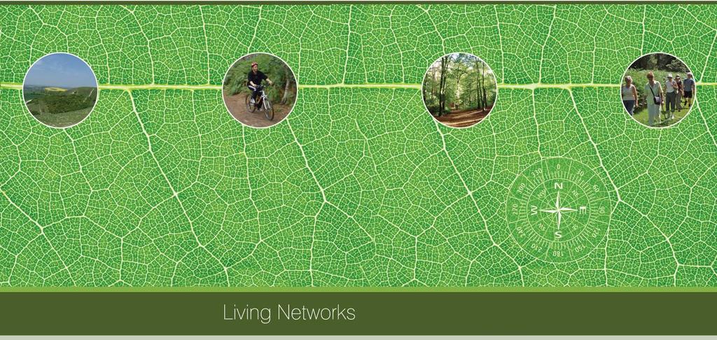
Billington Parish Green Infrastructure Plan
|
|
|
- Nickolas Harmon
- 5 years ago
- Views:
Transcription
1 Billington

2 Billington Parish Green Infrastructure Plan Methodology Following a presentation to the Annual Parish Meeting, The Greensand Trust was invited to attend the next Parish Council Meeting. The Parish Plan had just been launched and some of the priorities from this fitted in well with a proposed GI approach. Proposals for a public workshop were agreed and a set of Living Network Plans produced for the Parish. This information, together with large scale maps was used at the workshop with parishioners working in small groups to confirm the issues of importance to them and areas for protection or improvement. 22 people attended the first workshop. Following feedback from the individual working groups and agreement on issues to be taken forward a draft GI map was produced and taken back to a second public workshop. The date for the second workshop was agreed and advertised in Billington Bugle. 11 people turned up, four of which had not been to the previous meeting. At the second workshop the draft GI Plan was discussed changes agreed and an action plan of projects produced. Youth Workshop Young people were unrepresented at the workshops and a separate workshop was held for them. This workshop was advertised locally mainly through word-of-mouth between the residents because so few young people live in the village. 9 young people attended the workshop between the ages of 6 and 13 years four of which were girls and 5 were boys. Leighton Buzzard and Billington were examined together because most of the services and facilities for young people are focussed in Leighton Buzzard and most of the young people attend school in Leighton Buzzard. The results have been fed into the Leighton-Linslade Town Plan and the South Beds and Luton Green Infrastructure Plan. 2
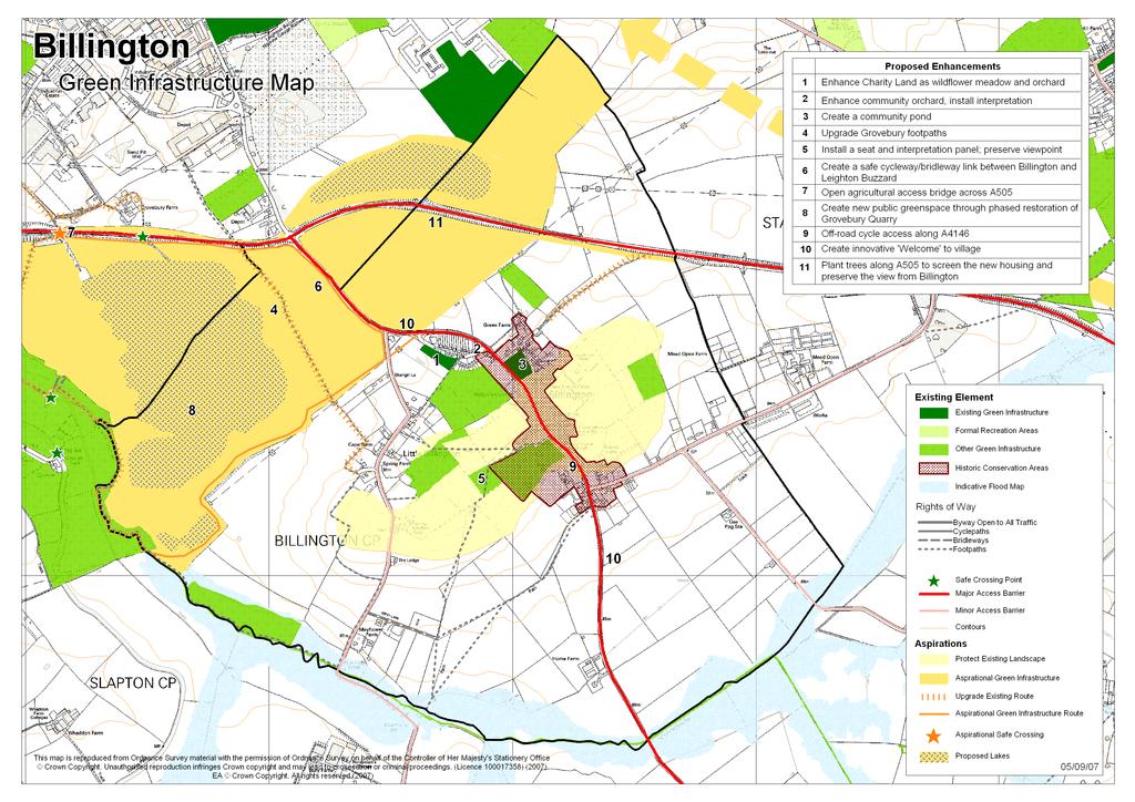
3 Action Plan Feature & Location Charity Land to the South of hill View Lane which is accessible to both Great Billington and Little Billington The Community Orchard (Old chipping site) Village Green Existing ROW network around Billington and Grovebury View points from Billington, particularly the hill top near the Church Off road cycle link between Billington and Leighton Buzzard Existing bridge across the A505, west of Billington Parish Grovebury Quarry west of Billington Proposed Enhancement/Action Enhance area as wildflower meadow and community orchard Hedgerow planting to fill gaps Install 2 benches on site Local residents to collect seeds from churchyard, grow themselves and plant in wildflower section Assess feasibility of and design a small nature trail to encourage natural play and inform visitors about wildlife in the area. Install interpretation board at entrance. Look into feasibility of creating a small community allotment area for everyone to share and work on. Plant flowers, in northern corner, which can withstand boggy/flooded areas in winter and dry soil in summer such as Marsh Marigold, Water Mint and Cuckoo Flower. Enhance community orchard and install interpretation Plant more damson trees Hold a pruning and care for your orchards course for parish Interpretation about the history of the prunes in the area, how and what they were used for, advise people when best to pick the fruit Work with the Bedfordshire community orchard group Create a community pond Excavate an area on the village green to create a small wildlife pond and plant marginal vegetation. Provide an area for recreation and relaxation and the opportunity for everyone to watch the pond life evolve. Install a bench. Encourage village to get involved in the creation and design of the pond. Upgrade Grovebury footpaths Write a Rights of Way Improvement Plan for Billington Work with Landowners (Church Commissioners and others) and site operators (Aggregate Industries) to negotiate an upgrade to a cycleway or bridleway. Install seat, interpretation panel, preserve viewpoint Find out who owns the land. Install a seat possibly a carved bench. Install interpretation about the expansive view across the Chilterns and the heritage of the area Create a safe cycle way/footpath link between Billington and Leighton Buzzard Work with Landowners (Church Commissioners) and site operators (Aggregate Industries) to negotiate pedestrian and cycle access between the existing footpath and the agricultural access bridge. Provide off-road cycleway access between Hill View Lane and Grovebury quarry footpaths. Assess feasibility of providing bridleway or cycle access from Footpath 7 parallel to the A505 to the new Sustrans bridge across the bypass near Tilsworth. Open agricultural access bridge across A505 Assess feasibility to use the bridge for pedestrian and cycleway use. Negotiate with landowners either side of A505 to bring the bridge into use and extend the footpaths either side. Create new public green space through phased restoration of Grovebury Quarry Negotiate phased restoration of Grovebury Quarry to be used for public access, wildlife habitats and recreation in the future. Restoration would include a 100ha lake and riverside meadows 3
4 9 A4146 dividing Billington, North to South Either end of the village Views from Billington into Leighton Buzzard with a traditional grazing regime. Off-road cycle access along A4146 Assess feasibility of providing alternative cycleway along Billington Road. Create innovative welcome to the village Approach Highways about installing a sign or statue or innovative planting to show visitors when entering the village. Plant trees along A505 to screen the new Leighton Buzzard housing from the view of Billington Use tree planting along the top of the bypass to screen the rooftops from the view of Billington. 4
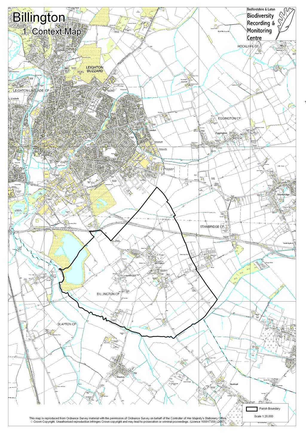
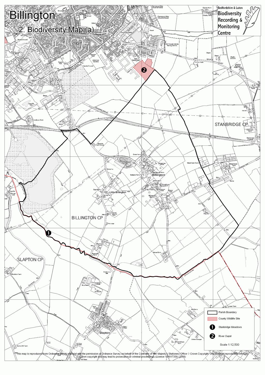
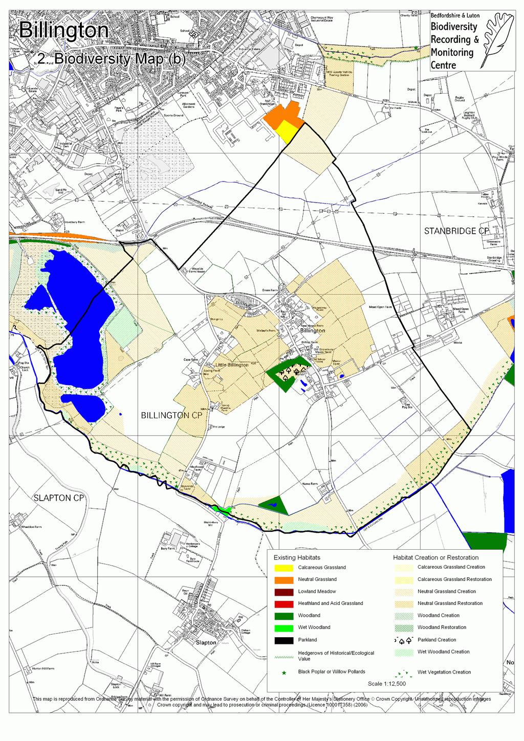
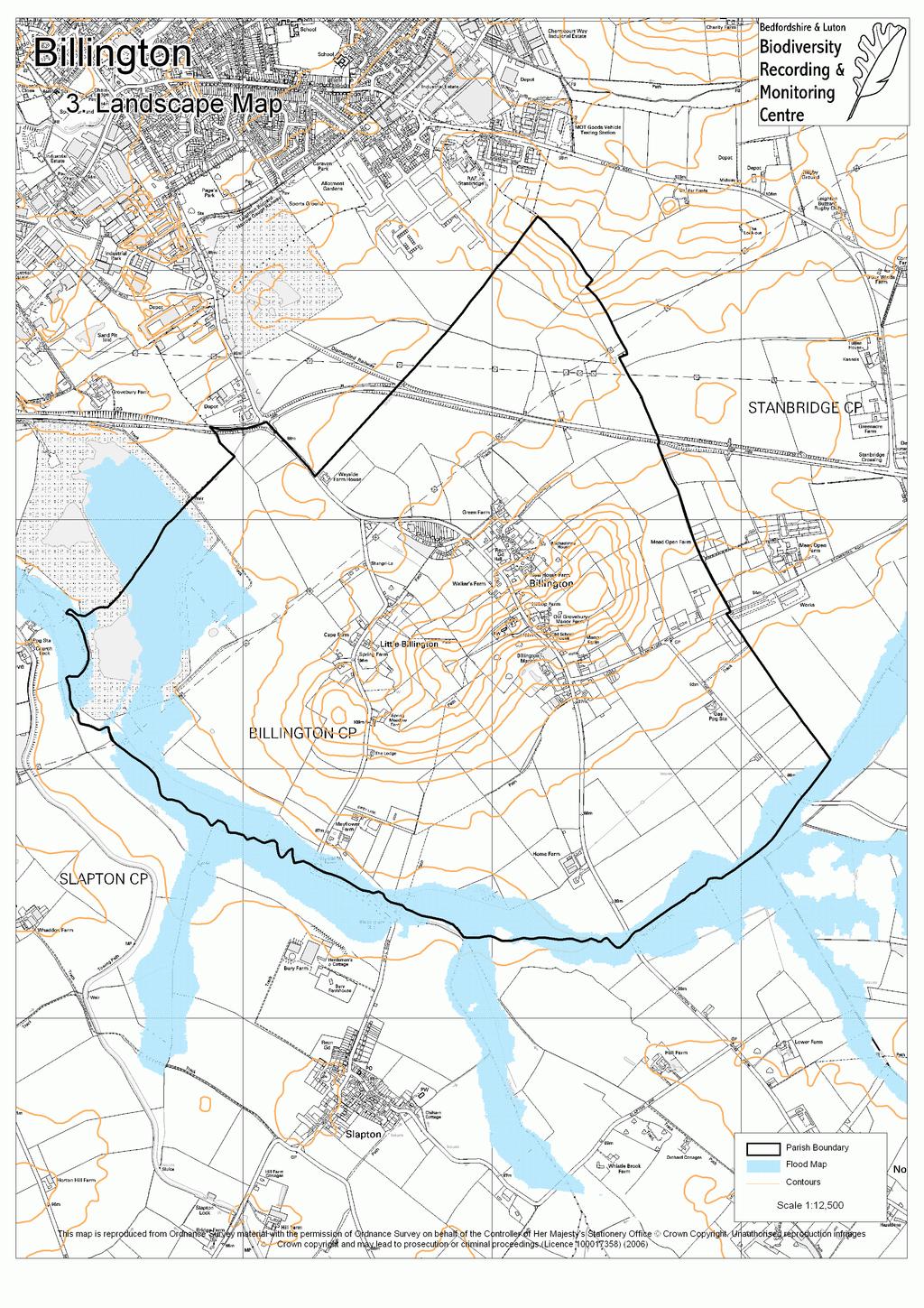
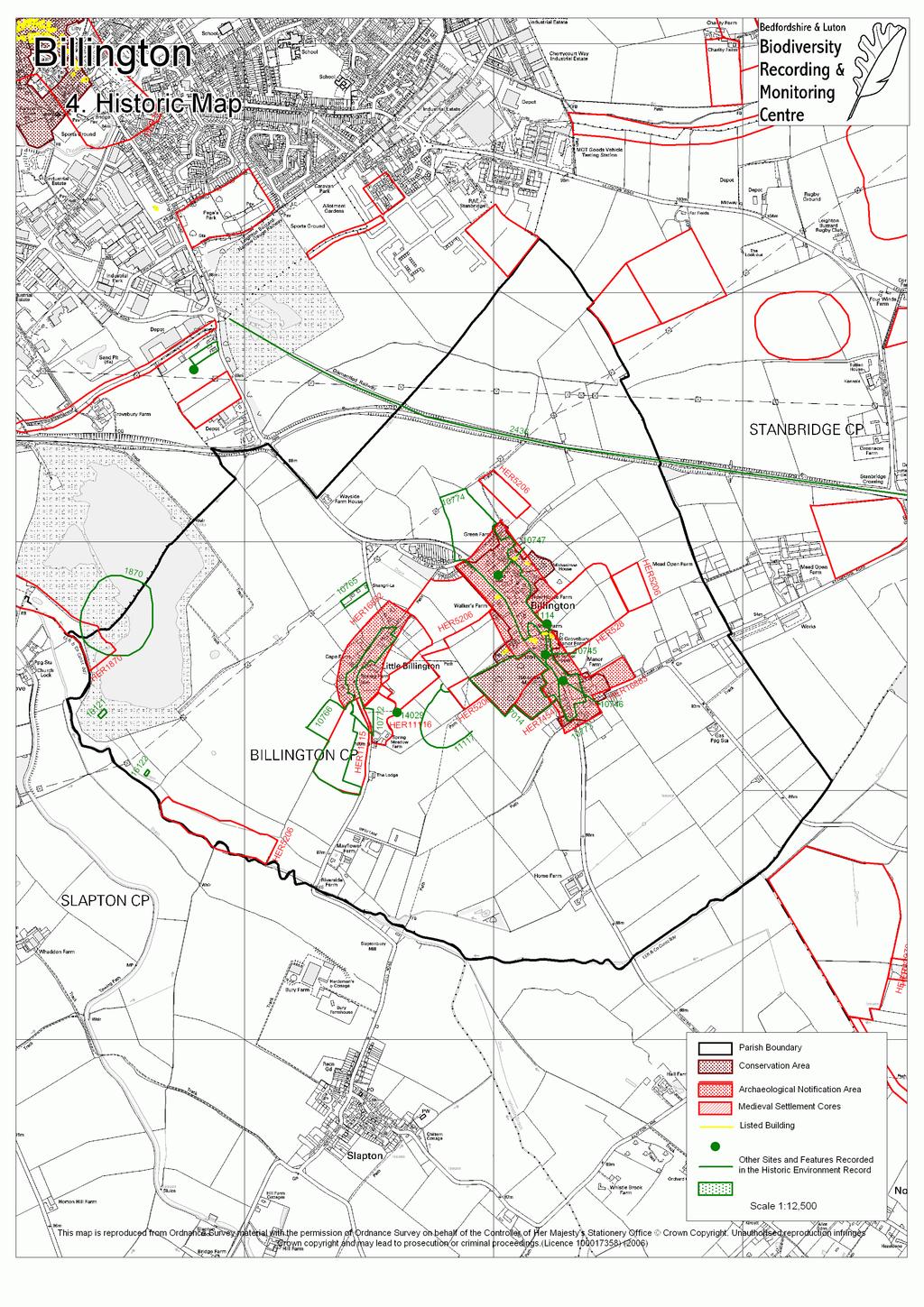
5 Introduction to Themed Maps 1) Context Map 2) Biodiversity Map Map (a) shows the locations of County Wildlife Sites (CWSs) within the parish of Billington. A CWS is a site that has been recognized as important for wildlife when assessed against a set of criteria. The selection guidelines consider aspects of the site such as size, diversity, rarity, fragility, typicalness and recorded history. Designation as a CWS does not confer protection on the site, or right of access, however for any significant change of land use the planning authorities will expect the wildlife interest to be taken into account alongside other normal planning considerations. Local conservation organisations may comment on planning applications that could affect a CWS. There are no Sites of Special Scientific Interest, Local Nature Reserves or Roadside Nature Reserves within the parish. Only designated sites are shown, although there may be other sites within the parish which are important for wildlife. Green infrastructure planning can help to link or buffer existing wildlife sites, providing them with increased protection from harmful activities and making their wildlife populations more sustainable. Map (b) shows some of the existing habitats within Billington and a suggestion of how this could happen. If you would like further information or advice about the wildlife in your parish, please contact either Bedfordshire s County Ecologist (Tel: or john.comont@bedscc.gov.uk) or The Wildlife Trust (Tel: or Bedfordshire@wildlifebcnp.org). The Bedfordshire and Luton Biodiversity Recording and Monitoring Centre (BRMC) has a wealth of records about the species seen in your parish and is beginning to compile habitat data. If you would like to access this resources please contact them (Tel: or brmc@bedsbionet.org.uk). 3) Landscape Map The landscape map shows the position of contours within your parish. It also has the areas at risk from a 1% chance flood from a river marked. Contours and flood zones can be useful when creating green infrastructure corridors. 4) Historic Map A variety of historic sites are shown on this map. Integrating these sites into green infrastructure plans can help to preserve parish history. The numbers next to most of the site boundaries represent locations in the Historic Environment Record (HER), which is kept at County Hall in Bedford. The table below gives a brief summary of each numbered site; more details are available from the HER, along with historic maps of your parish. Due to the scale of this map only Listed Buildings are shown, however, there are many other historically important buildings recorded. For advice or further information about historic areas in your parish please contact the Historic Environment Information Officer at Bedfordshire County Council (Tel: or Stephen.coleman@bedscc.gov.uk).
6 Number Site Description HER528 Hillfort 1959 map shows a single rampart earthwork and excavations produced Iron Age pottery, however, gravel working has disturbed the site. HER1870/ 1870 Grove Priory and Grove Pastures Grove Priory was founded in 12th century & dissolved Main priory buildings excavated before quarrying. Remains of fishponds and associated earthworks may survive in strip of land adjacent to River Ousel to the south west. HER5206 Ridge and Furrow HER7454 Billington Manor and Moat Site Large L-shaped pond shown on Tithe Map, possibly marking the site of a moated manor. HER11115 Earthworks Linear apparent in small field. HER11116 Earthworks Linear and other apparent earthworks on east side of road Branch Railway Line (Linslade to Dunstable) Opened in 1848 and used to carry coal and chalk. The last train ran in Coprolite Workings Within parish (not marked on map) Billington Manor Grounds Celt Axe head probably Neolithic some within parish (not marked on map) Pound and Village Pump Remains of the stone constructed pound adjoining the enclosure wall where there is a pump Town well May have become a pump at later date Public Pump An 1872 entry in the vestry minute book suggests a pump was needed for the poor, however, it is uncertain if it was ever erected Orchards Prune orchards around settlement for 1870s to 1914 (not marked on map) Brickyard Recorded on Tithe map of Brickyard Earthworks apparent in this field were possibly associated with brick making Green, Little Billington Green, Great Billington Green, Great Billington Original settlement was arranged on eastern edge of green, the area was enclosed in Earthwork Linear earthwork apparent Cropmarks/Soilmarks Traces of sub-circular cropmarks or soilmarks, possibly geological in origin Town Well Recorded on 1902 map annotation Ditch No longer present due to quarry extension Ditches & Post pit Post-pit formed an irregular circle with sloping sides down to a vertical pipe. It was filled with grey coloured clay containing patches of iron staining and some snail shells. 5) Open Space, Access and Recreation Map This map shows the positions of open spaces (e.g. golf courses, recreation grounds or school playing fields) within your parish. Not all of them are accessible to the public. Rights of Way are key to providing access to open spaces within green infrastructure plans. The rights of way map show was correct for May 2006, subsequent changes are not shown and there for the location of paths are not guaranteed. 6
7
8
9
10
11

12
13
14 A Chalk Arc Initiative Funded Project. Consultation and document preparation prepared by The Greensand Trust Mapping by the Bedfordshire & Luton Biodiversity Recording and Monitoring Centre
Mapping produced by the Bedfordshire and Luton Biodiversity Recording and Monitoring Centre
 Mapping produced by the Bedfordshire and Luton Biodiversity Recording and Monitoring Centre Chalton Parish Green Infrastructure Plan Methodology In April 2007 Chalton Parish Council were approached with
Shillington. Green Infrastructure Plan. October Shillington Parish Council
 Shillington Green Infrastructure Plan October 2010 Shillington Parish Council SHILLINGTON S GREEN INFRASTRUCTURE PLAN Introduction: Shillington s Green Infrastructure (GI) Plan is part of a programme of
Lidlington. Green Infrastructure Plan Lidlington Parish Council
 Lidlington Green Infrastructure Plan 20 Lidlington Parish Council Parish Green Infrastructure Plan Lidlington Introduction Lidlington s Green Infrastructure (GI) Plan is part of a programme of 9 parish
Welcome to our public exhibition
 About our development Welcome to our public exhibition This exhibition gives you the chance to view and comment on our proposals for a new residential development of 165 high-quality homes, along with
SPG 1. * the northern and western sections which are open fields used for pasture and grazing;
 SPG 1 1.0 INTRODUCTION This development brief is based on the allocation of the Priors Hall site for employment and countryside recreational purposes in the Corby Borough Local Plan. The brief is intended
ENVIRONMENTAL INVENTORY
 Hungarton Neighbourhood Plan ENVIRONMENTAL INVENTORY Sites scoring 25/36 or more (70%) are judged to be the most important environmental and community sites and are proposed as Local Green Space. Other
Environment Agency Flood Risk Map for the Village of Bridge
 Environment Agency Flood Risk Map for the Village of Bridge December 2016 21 Objective F. Conserving and Enhancing the Natural Environment The National Planning Policy Framework states that the planning
Roeshot & Burton SANG. Hinton Admiral Estate
 Who we are? The Hinton Admiral is the home of the Meyrick family and the Estate today is a 300-year old organisation. The Estate enjoys very diverse land types which range from heathland and river valley
Land at Three Elms, Hereford PRE-SUBMISSION EXHIBITION June 2016
 Design Principles Emanating from the key themes from the Community Planning Weekend and technical assessment conducted, a series of design principles were developed.these principles were presented during
APPENDIX A 6 CONCEPTUAL PRELIMINARY PLAN GUIDE AND CHECKLIST FOR MAJOR SUBDIVISIONS CARRBORO DEVELOPMENT GUIDE APPENDIX A
 6 CONCEPTUAL PRELIMINARY PLAN GUIDE AND CHECKLIST FOR MAJOR SUBDIVISIONS Conceptual Preliminary Guide/Checklist for Major Subdivisions Page 1 FORM: REVIEW DATE: CONCEPTUAL PLAN REVIEW 2000 REVIEWED BY:
Rudy Parish Neighbourhood Plan Steering Group Meeting 6/8/2018. Proposed Green Spaces (Continued from SG meeting of 2/7/18)
") Rudy Parish Neighbourhood Plan Steering Group Meeting 6/8/2018 Proposed Green Spaces (Continued from SG meeting of 2/7/18) NPPF: Green Space Designation The Local Green Space designation will not be appropriate
Rudy Parish Neighbourhood Plan Steering Group Meeting 6/8/2018 Proposed Green Spaces (Continued from SG meeting of 2/7/18) NPPF: Green Space Designation The Local Green Space designation will not be appropriate
Historic England Advice Report 26 August 2016
 Case Name: Kingsland Castle Case Number: 1435892 Background Historic England has been asked to review the scheduling for Kingsland Castle. The land on which the monument lies is understood to be for sale.
Kibworth Harcourt. Introduction. Introduction
 Introduction Introduction Welcome to this public exhibition on the proposals for the delivery of new homes on land at The Kibworths. The purpose of today s exhibition is to give you the opportunity to
Land at Rampton Road. Cottenham
 Land at Rampton Road Cottenham Introduction TEP is preparing an outline planning application for 54 dwellings on 6.9 hectares of land adjacent to Rampton Road, Cottenham on behalf of the owners Cambridgeshire
Slough International Freight Exchange Proposals, Colnbrook+
 Welcome Welcome to this exhibition, which is being held in connection with our proposals for a new freight exchange facility on land to the north of the A4. Please take this opportunity to look at the
SOUTH CAMBRIDGESHIRE DISTRICT COUNCIL. Planning and New Communities Director
 SOUTH CAMBRIDGESHIRE DISTRICT COUNCIL REPORT TO: Planning Committee 9 January 2013 AUTHOR/S: Planning and New Communities Director S/2270/12/FL FEN DRAYTON 850m long flood defence embankment ranging in
Green Infrastructure planning must be evidence led, thus the importance of this stage in collating your information and responses.
 Green Infrastructure Consultation Proforma Recipients: Andy Maginnis (Countryside Services) regarding access, recreation and tourism Ed Dursley (Transport) regarding access and movement Steve Bloomfield
Introduction. Welcome to this consultation regarding the draft redevelopment proposals for the former CeramTec factory on Sidmouth Road, Colyton.
 Introduction Welcome to this consultation regarding the draft redevelopment proposals for the former CeramTec factory on Sidmouth Road, Colyton. We are currently considering options for the mixed-use redevelopment
Wildlife and Planning Guidance: Neighbourhood Plans
 Wildlife and Planning Guidance: Neighbourhood Plans This Leaflet is one of a series of 4 Wildlife and Planning Guidance Leaflets and is intended to provide useful information to assist you to campaign
ABOUT CALA HOMES CALA HOMES
 WELCOME Welcome to this public consultation event for our proposed development on land to the east of Salisbury Road, in Hungerford. Thank you for taking the time to come along today. Homes and Wates Developments
Response by the Wiltshire Archaeological and Natural History Society
 Highways England Consultation A303 Stonehenge Response by the Wiltshire Archaeological and Natural History Society Background About the Society Founded in 1853 to educate the public by promoting, fostering
Archaeological evaluation at Willowdene, Chelmsford Road, Felsted, Essex
 Archaeological evaluation at Willowdene, Chelmsford Road, Felsted, Essex August 2013 report prepared by Ben Holloway on behalf of Mr Anthony McGurren Planning reference: UTT/13/0235 CAT project ref.: 13/07g
Rochford District Council Allocations Development Plan Document: Discussion and Consultation Document Sustainability Appraisal
 Option SWH1 Balanced Communities Option SWH1 1 To ensure the delivery of high quality sustainable communities where people want to live and work Will it ensure the phasing of infrastructure, including
Public Consultation. Land at Monks Farm, North Grove. Welcome
 Welcome Welcome to our public exhibition for development on Land at Monks Farm, orth Grove. Gallagher Estates and Gleeson Strategic Land are preparing an outline planning application for new homes, open
UTT/16/1466/DFO GREAT DUNMOW MAJOR
 UTT/16/1466/DFO GREAT DUNMOW MAJOR PROPOSAL: LOCATION: APPLICANT: AGENT: Reserved matters approval for the accesses to the site and principal roads within the site including spine road following outline
ENVIRONMENTAL AND LANDSCAPE MAPPING
 APPENDIX IV : Environmental and Landscape Mapping ENVIRONMENTAL AND LANDSCAPE MAPPING Calveley Neighbourhood Plan November 2016 ENVIRONMENTAL AND LANDSCAPE MAPPING Calveley Neighbourhood Plan Calveley
Site Assessment Technical Document Appendix A: Glossary
 Central Bedfordshire Council www.centralbedfordshire.gov.uk Site Assessment Technical Document Appendix A: Glossary July 2017 1.1.11-1 - ii Appendix A: Glossary Term Agricultural Land Classification AONB
WELCOME. Land North of STEVENAGE. We would like to thank you for attending our public exhibition today.
 WELCOME We would like to thank you for attending our public exhibition today. The purpose of this event is to share our proposals and hear your thoughts on our ideas. Members of the project team are on
LITTLE FRANCE PARK, EDINBURGH
 LITTLE FRANCE PARK, EDINBURGH INTEGRATING ACTIVE TRAVEL ROUTES WITHIN A MASTERPLAN FROM THE OUTSET Location: Implemented: Edinburgh, Scotland 2016 - ongoing CASE STUDY The Little France Park cycling and
Hampton Park North Littlehampton West Sussex
 North Littlehampton West Sussex SUMMARY Summary An opportunity to create a new community in West Sussex on the northern outskirts of Littlehampton with outstanding views across open countryside towards
The analysis of key visual characteristics and attributes that contribute to variations in the
 15.0 CHIGWELL/CHIGWELL ROW 15.1 Overview 15.1.1 Chigwell and Chigwell Row settlements are situated in the south of Epping Forest District, to the south of Abridge and southwest of Stapleford Abbotts. Both
Environmental and Landscape Mapping
 Environmental and Landscape Mapping In support of the Calveley Neighbourhood Plan November 2016 Project Name and Number: Calveley Neighbourhood Plan 16-025 Document Name and Revision: Environmental and
East Harptree Landscape & Character Assessment
 East Harptree Landscape & Character Assessment Produced by East Harptree Parish Council in consultation with local residents September 2014 Contents The Parish of East Harptree: Objective Introduction
The Gwennap Parish Vision Statement
 QUICK GUIDE What is a Neighbourhood Development Plan? Ultimately it is a document used by developers or anyone wishing to submit a planning application that describes the vision, strategy, plans, regeneration,
Rempstone Extension - East Leake 2014
 Overall Restoration of East Leake Quarry Sand Martin Face Southern Agricultural Corridor Wetland Ponds/Conservation Corridor following Sheepwash Brook Reinstated Bridleway/Footpaths Southern Agricultural
Programming Ideas for Parks Professionals
 Programming Ideas for Parks Professionals 6 How to Use this Information This is a list of ideas, suggestions and tips for promoting and incorporating the healthy in nature movement in your parks. Whether
BREEDON NORTHERN LIMITED
 Non Technical Summary CONTENTS 1 INTRODUCTION... 1 2 SITE DESCRIPTION... 1 3 DESCRIPTION OF THE DEVELOPMENT... 6 4 NEED FOR THE DEVELOPMENT... 8 5 KEY ISSUES CONSIDERED IN THE ENVIRONMENTAL IMPACT ASSESSMENT...
Land at Fiddington Hill Nursery, Market Lavington
 Land at Fiddington Hill Nursery, Market Lavington Briefing Report for Market Lavington Parish Council Persimmon Homes (Wessex) April 2016 Background This brief report has been prepared following the Market
Information about the site we need to take into account
 Site considerations Site Boundary Vehicular access Building with potential Contamination Pedestrian access View corridors to Church tanc e Information about site we need to take into account Site Boundary
Warwickshire County Council. Upper and Lower Brailes. Landscape Study
 Warwickshire County Council Upper and Lower Brailes Landscape Study Produced by WCC Landscape Architects March 2016 Landscape Assessment of Potential Development Sites within the parish of Brailes 1.0
1 THE OLD VICARAGE MANOR ROAD F GORING ON THAMES F OXFORDSHIRE
 1 THE OLD VICARAGE MANOR ROAD F GORING ON THAMES F OXFORDSHIRE 1 THE OLD VICARAGE MANOR ROAD F GORING ON THAMES F OXFORDSHIRE Pangbourne on Thames 5 miles F Reading 10 miles F Newbury 13 miles F Oxford
Welcome. Land adjacent Sandy Lane WALTHAM CHASE THE PROPOSED SITE
 Land adjacent Sandy Lane WALTHAM CHASE Existing Linden Homes developments Welcome Welcome to Linden Homes Southern s ( Linden ) public exhibition about its proposals for a range of high-quality homes for
Trumpington Meadows Country Park and Nature Reserve and Byron s Pool
 Trumpington History Trails Trumpington Meadows Country Park and Nature Reserve and Byron s Pool The River Valley South West of Trumpington 6 Walk or cycle approximately 5 miles/8 kms walk on pavements
Toddington Central Bedfordshire Stage 3 Green Belt Study December 2017
 Toddington Central Bedfordshire Stage 3 Green Belt Study December 2017 Site: ALP086 - Middle Lakes, Toddington Site size (ha): 2.83 Site: ALP086 - Middle Lakes, Toddington Site size (ha): 2.83 Site description
1. Local Plan Context
 1. Local Plan Context WHY ARE YOU HERE? ABOUT US PLANNING APPLICATION CONSULTATION Stewart Milne Homes are in the process of preparing a detailed planning application for a development of approximately
Section 4 - Public Realm & Landscape proposals Landscape Masterplan. Section 4 52
 - Public Realm & Landscape proposals Landscape Masterplan 52 Proposed Masterplan - Green Infrastructure Strategy District Park 4.33 Ha to provide Passive and active recreation with a large play area which
Shenley Neighbourhood Development Plan Pre-Submission Plan, Regulation 14 Consultation
 Amanda Leboff, Clerk Shenley Parish Council Shenley Neighbourhood Plan c/o Shenley Parish Council The Hub London Road Shenley Herts WD7 9BS Sent by email to: clerk@shenleyvillage.org Hertfordshire County
INTRODUCTION. Land south of Bishopswood Lane, Tadley
 0 INTRODUCTION THE SITE Introduction Gladman Developments Ltd. has successfully invested in communities throughout the UK over the past 0 years, developing high quality and sustainable residential, commercial
Reserved Matters application for a site that straddles the boundary between CBC and BBC
 BBC APPLICATION 15/02682/MAR NUMBER CBC APPLICATION CB/15/04294/RM NUMBER LOCATION Wixams Land at former storage depot, Bedford Road, Wilstead Bedfordshire PROPOSAL Reserved Matters Application for Strategic
INTRODUCTION. Land West of Main Road, Stanton Harcourt THE SITE. Why is the Site Suitable for Development?
 0 INTRODUCTION THE SITE Application Boundary Gladman Developments Ltd has successfully invested in communities throughout the UK over the past 0 years, developing high quality and sustainable residential,
Town of Peru Comprehensive Plan Executive Summary
 Town of Peru Comprehensive Plan Executive Communities that plan grow by choice, not by chance. A plan makes growth thoughtful, understandable, and predictable. A plan shows that a community is managing
Chalk, Cherries and Chairs Central Chilterns Landscape Partnership Scheme LANDSCAPE PARTNERSHIP DEVELOPMENT OFFICER JOB INFORMATION PACK
 Chalk, Cherries and Chairs Central Chilterns Landscape Partnership Scheme LANDSCAPE PARTNERSHIP DEVELOPMENT OFFICER JOB INFORMATION PACK How to apply Please complete our application form, together with
Appendix 2: List of superseded policies
 Appendix 2: List of superseded policies The table below sets out the policies that are to be superseded by this Local Plan. These policies will no longer be part of the development plan for Central Bedfordshire
Neighbourhood Planning Local Green Spaces
 Neighbourhood Planning Local Green Spaces Introduction... 2 1. Why green space is important... 4 2. Neighbourhood plans and green space... 6 3. Evidence... 8 Statutory designations... 9 Green space audit...
Statement of Community Involvement LAND OFF SOUTHDOWN ROAD HORNDEAN, HAMPSHIRE
 LAND OFF SOUTHDOWN ROAD HORNDEAN, HAMPSHIRE CONTENTS Page 1. Introduction 3 2. Pre-application Discussions 4 3. The Consultation Process 5 4. Consultation Feedback 7 5. Responses to Consultation Feedback
WILMCOTE NEIGHBOURHOOD PLAN
 WILMCOTE NEIGHBOURHOOD PLAN 1. Introduction. 1.1 David Holmes Planning Ltd has been instructed to advise Wilmcote Parish Council, who wish to prepare a Neighbourhood Plan. In particular we are asked to
Neighbourhood Planning Guidance Local Green Spaces
 Neighbourhood Planning Guidance Local Green Spaces Introduction This guidance note has been produced for communities preparing neighbourhood plans in North Dorset to help them to identify, assess and designate
8.0 Design and Form of Development 43/
 42/ 8.0 Design and Form of Development 43/ Rothwells Farm, Golborne/ Development Statement Figure 7. Site Constraints Key 44/ Site Boundary 360 Bus Route/Stops Existing Trees Underground Water Pipe Sensitive
Alder View. Introduction. Alder View. Harwell. The Vision. The Team. Taylor Wimpey
 Introduction Welcome to the public exhibition for, a development by Taylor Wimpey on the land south of Grove Road,. This exhibition will provide an overview of the development proposals for the site and
1.0 INTRODUCTION. Brantham Industrial Area Regeneration - Factory Lane - Brantham
 1.0 INTRODUCTION Welcome to this exhibition of our proposals for the regeneration of the Brantham Industrial Area located off Factory Lane in Brantham. This presentation will give you an opportunity to
PLACE WORKSHOP REPORT. A+DS SNH sustainable placemaking programme
 PLACE briefing WORKSHOP REPORT A+DS SNH sustainable placemaking programme INTRODUCTION This report summarises the outcome of a Scottish Natural Heritage workshop on placemaking which was held on Wednesday
To secure a Green Belt around Cambridge whose boundaries are clearly defined and which will endure for the plan period and beyond.
 4. GREEN BELT OBJECTIVES GB/a GB/b GB/c GB/d To secure a Green Belt around Cambridge whose boundaries are clearly defined and which will endure for the plan period and beyond. To maintain the purposes
If you require support to complete this form please contact Jim Holford who will arrange suitable support to meet your needs
 If you require support to complete this form please contact Jim Holford who will arrange suitable support to meet your needs Jim Holford 1 Hillside Farm Chacewater TR4 8LU 07584135801 jimholford@gmail.com
CHAPTER 18 - Strategy Area: Dundry and River Valleys
 This south-eastern part of the Community Forest is a complex area with a wide variety of different landscapes close together, including the Chew Valley, the southern part of the Avon Valley and the eastern
A new park will be delivered as part of the Elephant Park regeneration.
 A new park will be delivered as part of the Elephant Park regeneration. The exhibition boards presented here introduce the first phase of the new park that is scheduled to open in spring 2017 that has
Mississauga Waterfront. Parks Strategy - Draft
 Potential configuration for river s edge seating. Boating on Credit River: A regatta Boating on Credit River: Active enjoyment 5.2 Port Credit Memorial Park West Priority Park 5.2.1 Site Opportunities
Ebbsfleet Development Corporation
 Title of Paper Planning and Housing Delivery Report September 2018 Presented by Sub-Committee Mark Pullin, Chief Planning Officer Planning Committee Purpose of Paper and Executive Summary This paper provides
New Linear Park, public consultation results 26 February 2015
 FO Developments LLP New Linear Park, public consultation results 26 February 2015 Broadway (A663), J20 M62 / J21 M60, Oldham, Greater Manchester Number of people attended 58 Number of people answered 37
WELCOME. North East Haverhill. The Planning Process
 WELCOME North East The site to the North East of, known as Great Wilsey Park, is identified by St Edmundsbury Borough Council in its Core Strategy as capable of delivering a Sustainable Urban Extension.
Hill Park. Self-guided Circular Trail
 Staffhurst 2007:Chobham - use this layout 22/9/09 15:49 Page 1 Hill Park to Tatsfield NDW Chestnut Avenue The Avenue 1 2 Key Footpath Clarks Lane 7 6 3 5 4 NDW North Downs Way Self-guided Trail Site size:
SITE ASSESSMENT FORM
 Appendix 2 SITE ASSESSMENT FORM 1. Site information Settlement: Colwall Main Village Site name: SITE 1 Part of vacated Colwall school site and adjacent area Site address: Walwyn Road Site area (hectares):
LAND AT WEST YELLAND. Environmental Statement Non-Technical Summary Welbeck Strategic Land LLP
 LAND AT WEST YELLAND Environmental Statement Non-Technical Summary Welbeck Strategic Land LLP May 2014 Quality Management Issue/revision Issue 1 Revision 1 Revision 2 Revision 3 Remarks Draft FINAL Date
NORTH WEST LEEDS COUNTRY PARK AND GREEN GATEWAYS PROJECT. Country Parks Officer Douglas Louis
 NORTH WEST LEEDS COUNTRY PARK AND GREEN GATEWAYS PROJECT Country Parks Officer Douglas Louis Vision To Preserve, Improve and Promote Green Spaces and their Connectivity for People & Wildlife in North West
Appendix 2 Waterbeach Greenway Review
 Appendix 2 Waterbeach Greenway Review Nigel Brigham & Associates A report for 1 Introduction This report is based on fieldwork carried out in 2016 to review the Greenway network around Cambridge as shown
Am I at risk of flooding?
 Am I at risk of flooding? Crindau Flood History he dangers of flooding are nothing new to the community of Crindau. he low lying area has flooded a number of times in the past. Most notably in 1981 when
Local Wildlife Sites in Leicestershire and Rutland
 Local Wildlife Sites in Leicestershire and Rutland What are Local Wildlife Sites? From mystical ancient woodlands to quiet churchyards and bustling flower-rich roadsides; and from field-bordering hedgerows
BISCUIT RUN PARK MASTER PLAN
 BOARD OF SUPERVISORS November 14, 2018 BISCUIT RUN PARK MASTER PLAN COUNTY OF ALBEMARLE ANHOLD ASSOCIATES Contents Project Introduction Property Background County Park Planning Process Existing Site &
~~ ~~ ~~ In this lesson, students explore their route to school, observing building types, street layouts and public spaces along the way.
 ~~ ~~ ~~ NEIGHBOURHOOD, VILLAGE, TOWN, CITY..,. p~-~~ Lesson 2: Buildings, Streets and Public Spaces In this lesson, students explore their route to school, observing building types, street layouts and
WELCOME LAND EAST OF TYE LANE, WALBERTON. Above all, it s about people
 WELCOME Welcome to this public exhibition relating to our draft residential proposals for the land east of Tye Lane, Walberton. Today gives you the opportunity to have an active role in shaping these ideas
INTRODUCTION NORTH HEYBRIDGE GARDEN SUBURB
 INTRODUCTION This event is being hosted by the promoters of the proposed North Heybridge Garden Suburb who are working with Maldon District Council and other key stakeholders on the preparation of a comprehensive
Welcome to our public exhibition
 About Our Scheme Welcome to our public exhibition This exhibition gives you the chance to view and comment upon our emerging proposals for a new residential development of 68 new homes on the site of the
Mendota Heights 2040 Comprehensive Plan Draft Vers
 4 Parks and Trails The City of Mendota Heights boasts a variety of recreational and open space opportunities. Few cities can claim access to regional trails, riverside and lakeside parks, scenic bluffs
BEDFORD BOROUGH COUNCIL PLAN IMPLEMENTATION MONITORING REPORT
 BEDFORD BOROUGH COUNCIL PLAN IMPLEMENTATION MONITORING REPORT 2017-18 Summary 1 Progress on local development documents 1 Local development documents adopted in the monitoring period 1st April 2017 31st
E16: MAINTENANCE OF LANDSCAPED AREAS
 HIGH SPEED TWO INFORMATION PAPER E16: MAINTENANCE OF LANDSCAPED AREAS This paper outlines the proposed approach to the maintenance of landscaped areas created for HS2 Phase One. It will be of particular
NON-TECHNICAL SUMMARY
 Proposed Sand and Gravel Extraction and Associated Processing Operations with Restoration to a Mixture of Agriculture and Nature Conservation including Areas of Shallow Water at Hedgeley, Northumberland
New horse training area, Manor Farm, Great Kimble, Buckinghamshire
 New horse training area, Manor Farm, Great Kimble, Buckinghamshire An Archaeological Watching Brief For Redwing Structures (Marlow) Limited by Andy Taylor Thames Valley Archaeological Services Ltd Site
WELCOME GYPSY LANE. Wider Site Location plan. Proposals for the development of LAND OFF FOXLYDIATE LANE WEBHEATH. Proposals for the development of
 WELCOME The developers are preparing an outline planning application for a residential led development and need the community s views in order to develop the proposals further WHAT IS PROPOSED? A high
Site ref: AS06 Site Name or Address: Murreys Court, Agates Lane
 Site ref: AS06 Site Name or Address: Murreys Court, Agates Lane Proposed Land Use: Total Site Area (Ha): Housing 1.85 Ha Description: It is understood that the owner has no plans to dispose of the site
Welcome to our public exhibition
 Welcome to our public exhibition This public exhibition gives you the opportunity to view and comment upon our emerging plans for a new residential development at Oaklands College in St Albans. Our proposals
Blandford Forum Town Council, Blandford St Mary Parish Council and Bryanston Parish Council
 Blandford Forum Town Council, Blandford St Mary Parish Council and Bryanston Parish Council Blandford + Neighbourhood Plan 2 Pre-Submission Plan Consultation (November 2018) Representations submitted on
01 Welcome. Why are we here?
 01 Welcome Why are we here? In July 2014 GreenSquare unveiled its plans for 1500 homes to the local community providing much needed houses during the first half of the Stroud District Local Plan period.
Test Valley Borough Council Southern Area Planning Committee 8 January 2019
 ITEM 11 APPLICATION NO. 18/02218/FULLS APPLICATION TYPE FULL APPLICATION - SOUTH REGISTERED 23.08.2018 APPLICANT Rugby Football Union SITE The Trojans Club, Stoneham Lane, Eastleigh, SO50 9HT, CHILWORTH
Briefing Document of CNP. June 2017
 Cholsey Parish Council Cholsey Neighbourhood Plan Briefing Document of CNP June 2017 Cholsey Neighbourhood Plan Page! 1 of! 8 Cholsey Plan Briefing v1.4 Page Left Intentionally Blank Cholsey Neighbourhood
The Illinois Department of Transportation and Lake County Division of Transportation. Route 173, including the Millburn Bypass
 The Illinois Department of Transportation and Lake County Division of Transportation welcome you to this Public Hearing for U.S. Route 45 from Illinois Route 132 to Illinois Route 173, including the Millburn
PART 2 SOUTH DOWNS NATIONAL PARK AUTHORITY SECTION 1 SCHEDULE OF APPLICATION RECOMMENDATIONS
 42 PART 2 SOUTH DOWNS NATIONAL PARK AUTHORITY PLANNING COMMITTEE REPORT OF THE SERVICE MANAGER PLANNING DEVELOPMENT Applications to be determined by the council on behalf of the South Downs National Park
LANDSCAPE CHARACTER ASSESSMENT
 THE COUNTY DURHAM LANDSCAPE CHARACTER ASSESSMENT FOREWORD The landscape of County Durham is one of great contrast and diversity. From the North Pennines in the west to the Durham Coast in the east it contains
Chairman and Members of the Planning and Development Committee. Thomas S. Mokrzycki, Commissioner of Planning and Building
 LA.09.TOR (Toronto) DATE: TO: FROM: SUBJECT: Chairman and Members of the Planning and Development Committee Thomas S. Mokrzycki, Commissioner of Planning and Building Central Waterfront Secondary Plan
Watford Local Plan Part 2 Publication Stage Environmental Report. Appendix 3: Consultation Comments
 Watford Local Plan Part 2 Publication Stage Environmental Report Appendix 3: Consultation Comments August 2016 Appendix 3 - Responses to Consultation of the Local Plan Part 2 As required by the SEA Directive,
Archaeological trial-trenching evaluation: New Hall School, The Avenue, Boreham, Essex. July 2015
 Archaeological trial-trenching evaluation: New Hall School, The Avenue, Boreham, Essex report prepared by Ben Holloway on behalf of New Hall School Planning reference: 14/01846/FUL CAT project ref.: 15/04i
Land adjacent to Dingle Dock, Front Street, East Garston
 Land adjacent to Dingle Dock, Front Street, East Garston An Archaeological Watching Brief for Dr J Davies by Jo Pine Thames Valley Archaeological Services Site Code DEG99/82 January 2000 Summary Site name: