City of Newaygo Downtown and Riverfront Plan 2010
|
|
|
- Percival Young
- 5 years ago
- Views:
Transcription


1 City of Newaygo Downtown and Riverfront Plan 2010

2

3 City of Newaygo Downtown & Riverfront Plan Acknowledgments City Manager Jon Schneider This Plan was adopted by the Planning Commission On, 2010 Deputy City Manager Rich Blachford City Council Ed Fedell, Mayor Wayne Bumstead, Council Member Douglas Day, Council Member Roger Palmiter, Council Member Jane Parsley, Council Member Carl Mast, Council Member Rachel Wisner, Council Member City Planning Commission Dave Chambers, Chairman Douglas Day, Secretary Ron Armstrong, Planning Commissioner LeeAnn Clor, Planning Commissioner Robbin Faulkner, Planning Commissioner Wayne Fetterley, Planning Commissioner Art Westcott, Planning Commisisoner Sandy Williams, Planning Commissioner Ron Wight, Planning Commissioner Special Thanks To Newaygo County Historical Museum (Historical Photos) Prepared By 324 Munson Avenue. Traverse City, MI i Introduction

4 City of Newaygo Downtown & Riverfront Plan Table of Contents Introduction Downtown and Riverfront Profile Regional Setting Recent Downtown Planning Initiatives Downtown and Riverfront District Profile Physical Attributes Streetscape Parking Buildings Circulation Signs Public Art Refuse Enclosures Project in Progress or Under Development Vision, Objectives and Strategies Implementation Action Strategies ii Introduction

5 City of Newaygo Downtown & Riverfront Plan iii Introduction

6 City of Newaygo Downtown & Riverfront Plan Introduction Downtowns are the social, cultural and economic hubs for most cities. Downtowns can also function as a barometer for an entire community - defining the identity and character of a community. In the case of Newaygo, the unique combination and close proximity of the downtown to the Muskegon River has helped the community be known as an American City with a Riverstop. In recognition of this unique combination, Newaygo has developed a Downtown and Riverfront Plan. The Downtown and Riverfront Plan establishes the vision and expectations for the future development of Newaygo s downtown and riverfront. The Downtown and Riverfront Plan also represents the framework for future public and private investment in the downtown and riverfront. In an effort to complement and tie in with other land use planning issues, the Downtown and Riverfront Plan has been incorporated into the city master plan. The Downtown Plan has been prepared under the direction of and with direct participation by the City of Newaygo Planning Commission and City staff. The Downtown and Riverfront Plan was established by the Planning Commission with the understanding that the downtown and riverfront will define the identity and character of the Newaygo community and that a successful downtown and riverfront will be measured by four community quality indicators 1. Social. Successful downtowns provide for social interaction on a community scale. Successful downtowns draw people of all ages to a common, shared centralized location where they can interact, eat, shop, experience culture, attend celebrations and events, be active and live. Successful downtowns should be a place where people want to go, not just where they have to go. Economic. Successful downtowns attract people, business and investment. Successful downtowns can increase home values throughout the community. As positive identity is enhanced, downtown occupancy and rental rates increase and investment becomes less risky. Tax dollars stay within the community. Public investments in downtown can instill confidence in the private sector and leverage additional investment. You can t rely on bringing people downtown; you have to put them there. Jane Jacobs - Death and Life of Great American Cities Physical. Successful downtowns continually help to improve and maintain the appearance of a community. Successful downtowns support and encourage the rehabilitation of historical buildings - preserving architectural and human history. 1 Best Practices + Investment = Downtown Success - Presentation provided at the 2009 Michigan Association of Planning Conference. David Birchler, AICP, PCP and Jill Bahm, AICP Birchler Arroyo Associates, Inc. 1 Introduction
7 City of Newaygo Downtown & Riverfront Plan Civic. Successful downtowns often help to establish civic pride. Citizens have more financial and emotional stake in the community. As a result, more people get involved in local government activities. More eyes and ears on the street can help keep the community safer. 2 Introduction

8 Downtown and Riverfront Profile Regional Setting Downtown Newaygo and the riverfront form the historical, cultural and economic center of the City. Their character and relationship to each other is how the community has been and continues to be defined. For the purpose of this plan, the Downtown and Riverfront encompasses about 355 acres. (please see figure 2.1) It includes the Mill Town Neighborhood, the primary shopping district along M-37 (downtown), the Michigan Agricultural Commodities, Inc. (MAC) facility, Riverfront Parks and large natural areas along the Muskegon River. Rail Transportation - Rail was used to ship lumber out and bring vacationers into Newaygo. Pictured blow is the rail bridge over the Muskegon River - it still stands today. Throughout its history, Downtown Newaygo and the Muskegon River have been the focal point of activity in the City. In the 1800 s, the Penoyer and Brooks families established Newaygo s first saw mill near the present day location of the Michigan Agricultural Commodities, Inc. (MAC) facility. The two families were drawn to the area for its abundance of virgin white pine and proximity to the Muskegon River (for floating logs). The lumber mills thrived for many years. Lumber was shipped throughout the region over a series of inter-connected rail lines. Over the years, due to its close proximity to Grand Rapids and Chicago and an abundance of natural resources for recreation, Newaygo also became a popular vacation destination. Today, the downtown continues to serve as the cultural and economic center of the city. Many of the historic buildings have been restored and re-adapted into new uses - supporting locally owned retail stores and restaurants. The Muskegon River is used to support recreation activities and a thriving tourist, adventure sport and fishing industry. Recent Downtown Planning Initiatives In the mid 1980 s, in response to a deteriorating and largely vacant downtown, public officials, business owners and interested citizens established the Revitalization Committee. The new committee was charged with revitalizing the downtown - attracting business and investment, improving public space and preserving historical character. Over the next 25 years, the committee and public officials initiated a number of initiatives, tools and programs to support the revitalization of Newaygo. At the same time, community leaders began to pursue a number of grant opportunities to help fund the revitalization efforts The following pages describe some of the key initiatives, tools and programs that were initiated to help revitalize Newaygo. Muskegon River - Today, the Muskegon River supports a variety of recreation activities, such as tubing. 3 Downtown and Riverfront Profile
9 Figure Downtown and Riverfront Profile
 to prepare a Downtown Business District Plan that outlined ways to improve the downtown business district, the riverfront, parking, circulation and aesthetics.")


10 Downtown Business District Plan. In 1985, the City of Newaygo hired WBDC, Inc. (a planning and architecture firm) to prepare a Downtown Business District Plan that outlined ways to improve the downtown business district, the riverfront, parking, circulation and aesthetics. The plan resulted in recommendations for new parking areas, pedestrian walkways and the renovation of existing landscape and cultural interests. Tax Increment Financing Authority (TIFA). In 1986, the City of Newaygo established a TIFA to provide a funding mechanism for the revitalization plans established under the Revitalization Committee and the Downtown Business District Plan. The TIFA board established Development Area Number One and Development Area Number Two - designated areas for which funding would be directed to revitalize existing facilities and support commercial growth. In addition, the TIFA board identified seventeen specific projects/improvements for the two development areas. In an effort to assemble enough funds to initiate a number of different projects at one time, TIFA dollars were not utilized until River Stop Landing District - In 2003, city officials initiated several capital improvement projects within the downtown area - helping to establish a more pedestrian friendly, interesting and inviting downtown. Before and After photos are shown below. Property Maintenance Ordinance. In 2007, the City of Newaygo established a new zoning ordinance to improve the maintenance of property throughout the city. The new property maintenance was specifically targeted to improve the character, and safety of rental units within the city. River Stop Landing District. In 2003, construction began on several capital improvement projects within the downtown - in the newly designated River Stop Landing District. Projects included the construction of two new public parking lots (on each side of M-37), streetscape improvements (e.g. sidewalks, lighting, landscaping, etc ), new water and sewer infrastructure and the renovation of several rental housing units. Each of the projects dramatically changed the look, feel and activity level of the downtown. The projects also increased the walkability of the downtown, provided for better vehicular access and provided for better pedestrian access to storefronts. In addition to utilizing the TIFA funds discussed earlier, local officials were able to secure grant funding for these projects from an unprecedented number of state and federal agencies and programs including, the Michigan State Housing Development Authority (MSHDA), Michigan Department of Transportation (MDOT), the United States Department of Agriculture - Rural Development Program and Community Development Block Grant (CDBG) funds. Downtown Art Committee. In 2004, the City of Newaygo established a Downtown Arts Committee and commissioned local artists to paint murals throughout the downtown area. 5 Downtown and Riverfront Profile

11 Overlay Shopping District. In 2004, Newaygo established the Principle Shopping District (PSD) zoning overlay in the River Stop Landing District. The PSD overlay was designed to improve the character and architectural details of the downtown, improve parking and eliminate blight. In addition, the city initiated a program to provide for the maintenance of the PSD. Downtown and Riverfront District Profile Downtown Newaygo and the Riverfront have a number of valuable assets. Downtown Newaygo is walkable and pedestrian friendly, has a familiar small-town charm, a number of historic buildings and accessible parking. People and families throughout the region are drawn to recreation opportunities and community events throughout the year. However, there are many things that could be improved to make the downtown more inviting. The retail mix could use more variety and the type of restaurant offerings could be broader. In an effort to attract entrepreneurial and creative workers (and their families) to the city, local officials have been working to develop more white-collar professional businesses and resources. Cultural Activities - Newaygo hosts a number of activities and events throughout the year. (Pictures provided by Newaygo Naturally Video) Once you arrive, the Riverfront is accessible to pedestrians and can be utilized for fishing and recreation activities. However, pedestrian connections (especially from the downtown) are limited by the large MAC facility. The natural, vegetative shoreline along the river is preserved and water quality is not an issue. The following section describes the physical characteristics of the downtown and riverfront areas. In an effort to better describe and identify the distinct characteristics of the downtown and riverfront the planning area was categorized into five distinct districts. Figure 2.2 illustrates the location of these districts. Riverbank District Located along the Muskegon River, the Riverbank District is a large, rugged area that remains predominately in its natural condition. Riverfront Park - Riverfront Park includes a non-motorized pathway, playground equipment and fishing/view platforms. Riverfront Park District The Riverfront Park District lies along the Muskegon River. The district is defined by Riverfront Park - Phase One and Two. The parks include a non-motorized pathway, fishing and view platforms, parking, picnic areas, river access and playground equipment. 6 Downtown and Riverfront Profile

12 Figure 2.2 Riverfront Park River Landing Downtown River Stop Landing Mill Town Neighborhood Riverbank 7 Downtown and Riverfront Profile
 facilities.")


, historic church buildings, sidewalks and tall mature trees.")
13 River Landing District The River Landing District is bordered by Water Street to the east, Wood Street (and downtown) to the south and Riverfront Park to the south and west. Currently, this area is home to the Michigan Agricultural Commodities, Inc. (MAC) facilities. The bulk of the large industrial facility is located on the north end of the site, adjacent to the non-motorized pathway at Riverfront Park. These facilities include seven large cement and metal silos used to store grain. The primary entrance to the facility is located at south end of the site. Railroad tracks also run through this area. These features combine to create a physical barrier between the riverfront and the downtown. Mill Town Neighborhood District The Mill Town Neighborhood District lies immediately adjacent to downtown Newaygo. The neighborhood encompasses about five square blocks and is bordered by Quarterline Street to the South, M-37 to the east, and a dense forest to the north (the shoreline of the Muskegon River). The neighborhood features many well-kept historic homes (with front porches), historic church buildings, sidewalks and tall mature trees. The neighborhood is also defined by the sharp landscaped grade of Quarterline Street, which forms a distinctive edge to the neighborhood. Downtown - River Stop Landing District The Downtown District is defined by the historical buildings that front M-37 (also known as State Road.) This part of downtown is home to several retail stores, restaurants and bars. The facades of many of the historic buildings have been restored. The back-end section of downtown is located off Wood Street, behind the buildings and a parking lot on the west side of M-37. This area features several new buildings, including a new post office. A small portion of downtown is located between Wood Street and Water Street and features more modern buildings. The City offices and the library are located on the east side of the M-37. River Landing District - This area is home to the MAC (pictured below) and is a physical barrier between the downtown and riverfront. Mill Town Neighborhood District - The Mill Town neighborhood features several historic homes with front porches and tall mature trees. 8 Downtown and Riverfront Profile


14 Physical Attributes Plantings - Examples of plantings in Downtown Newaygo. Streetscape Plantings. Several businesses have placed plantings in the sidewalk area along M-37. The plantings add to the overall quality of the streetscape, create interest for pedestrians and enhance individual storefronts. In addition, the city has planted street trees that will continue to mature and provide shade for pedestrians as well as aesthetic benefits. The city and several businesses have also placed plantings near parking areas which create a buffer between pedestrians and cars, reduces storm-water run-off and creates interest for pedestrians. Amenities. In 2003, the city initiated several streetscape projects within the downtown. These projects included the placement of several amenities throughout the downtown. An attractive lighting and banner system was installed along M-37. High quality benches and trash receptacles were placed around the downtown and a sound system was added to nearby parking areas. Brick pavers and pedestrian crosswalks were added at busy intersections and a plaza (with clock tower) was erected at the corner of M-37 and Quarterline Road. The riverfront also has a number of amenities including, two large playgrounds, a non-motorized pathway, picnic benches, grills, a covered pavilion and fishing/view platforms. Amenities - Examples of amenities in Downtown and the Riverfront. Gathering Spaces. Gathering spaces provide locations for informal meetings as well as formal celebrations of the community. One of the largest gathering spaces in the downtown is Brooks Park. The park has a large band shell and often hosts many of the community s large events and festivals. Other gathering spaces include the gazebo in front of the library and the two outdoor seating areas (facing the east parking lot) and the pavilions at Shaw Park and Riverfront Park Phase I. Gathering Spaces - Examples of gathering spaces in downtown Newaygo 9 Downtown and Riverfront Profile


 has allowed many business")


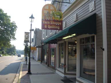
15 Parking On-Street Parking. On-street parking is provided along the east side of M-37 and most side-streets within the downtown. Parking - Downtown Newaygo includes both on-street and off-street parking. Off-Street Parking. The recent improvements to the downtown have resulted in the development of two large, surface parking lots. The parking lots are well screened and located behind the downtown buildings. The lots provide for ample parking and convenient pedestrian access to the stores along M- 37. The parking areas are well-marked, denoted with formal entryway features, and include pedestrian walkways. Parking near the riverfront is provided by two medium-sized surface parking lots. Parking - Off-street parking is located behind buildings, well marked and denoted with unique features. Buildings There are several great historical buildings located in the downtown. Funding assistance provided under a MSHDA grant program (in additional to their own private investment) has allowed many business owners to restore the facades of many of the historical buildings. The restored storefronts have added and architectural element to the downtown. However, there are several storefronts that still have not been restored and are void of character. Building frontage along M-37 is mostly consistent. However, there are a couple of large gaps located in mid-block areas. The scale and height of the downtown buildings are generally consistent. Buildings are either one, two or three stories. However, there are some examples of neighboring buildings that appear to be disproportionate. Due to the period in which many of the buildings were constructed, most downtown buildings are constructed of brick. However, several new buildings (and additions to existing buildings) have been constructed with different and inconsistent materials. Buildings - Downtown Newaygo still has several lifeless storefronts (with no windows) and disparities in materials and scale. Buildings - Downtown Newaygo features many restored build facades. 10 Downtown and Riverfront Profile


16 Circulation Street Patterns. Downtown Newaygo is generally served by one, two-lane road (M-37). Traffic is controlled along M-37 by a traffic signal at the corner of M-37 and Quarterline Street. The backend of the downtown is served by Water and Wood Street. Entryways. There are three primary entryways into Downtown Newaygo: (1) M-37 from the north; (2) M-37 from the south; and (3) Quarterline Street from the east. The entryway from the north is a long downhill approach that begins about a mile north of the city near Resurrection Life Church. Most of the city can be seen from the top of this approach. A Newaygo billboard is located near the top of this approach. A Welcome to Newaygo - River Stop Landing District welcomes travelers as soon as they pass over the Muskegon River. The roadside along this entryway remains heavily vegetated, establishing a clear delineation between the rural and urban areas of Newaygo. The entryway from the south is a short downhill approach that begins about a ¼ mile south of the downtown. There is not a Newaygo billboard in this area. However, there is a Welcome to Newaygo - River Stop Landing District sign that greats visitors as soon s they approach the downtown area. Much like the northern approach into the downtown, the roadside along this entryway remains heavily vegetated - establishing a clear delineation between the suburban development near the M-37 and M-82 intersection and downtown Newaygo. Quarterline Street is another downhill approach into Downtown Newaygo. The roadside along this narrow city street is also heavily vegetated. However, the Mill Town Neighborhood is visible along this approach. Entryways - There are three primary entryways into the downtown. Welcome to Newaygo signs greet visitors along the north and south M-37 entrance s of downtown. Non-Motorized Transportation - A large staircase connects the neighborhood above the hill with downtown. There are several mid-block pedestrian pathways connecting parking areas with shops on M-37. Riverfront Park includes a paved linear pathway. Non-Motorized. Transportation. Downtown Newaygo is pedestrian friendly. Sidewalks and midblock pedestrian pathways link parking areas with the shops on M-37. A large staircase provides pedestrian access from the downtown to the neighborhood on the hill and the historic upper elementary school building. Riverfront Park has a long paved linear pathway that traverses along the Muskegon River. The north entrance to the pathway is accessible by pedestrians and is located near Water Street in the downtown. The southern entrance primarily is accessible by automobile. 11 Downtown and Riverfront Profile


17 Signs Business Signs. Business signs throughout downtown Newaygo have different sizes, heights and placements. Local businesses utilize wall signs, window signs and projecting signs. Many of the older signs appear to be outdated, hard to read and constructed of materials that do not compliment the historic character of the surrounding buildings. Many of the newer signs are eye-catching, easy to read and add character the building. However, in some instances, the materials of the new signs may not compliment the historic character of the surrounding buildings. Business Signs - Many of the older business signs in downtown Newaygo appear to be outdated and unsympathetic to the historical character of the downtown buildings. Wayfinding and Informational Signs. Currently, there are no wayfinding or informational signs located in the downtown or riverfront areas of Newaygo. Wayfinding systems help to assist both motorists and pedestrians navigate to major destination points within a defined environment. Wayfinding systems can include signs, maps, banners, and information kiosks. Informational signs can serve many functions. Interpretive signs can inform visitors about the natural environment (e.g., watersheds and eco-systems), community programs (e.g., beach-erosion, water quality) or community history. Often, the short stories and/or information described through interpretive signage can help build a sense of place, increase public awareness, and help demonstrate a commitment to a specific mission or program. Wayfinding & Informational Signs - Examples of wayfinding and informational signs in Traverse City. 12 Downtown and Riverfront Profile

18 Public Art The downtown and riverfront areas have a few examples of public art. Several murals have been placed along the east facade of the public parking lot. Near the riverfront, a unique fish sculpture has been located near the parking lot. The public amphitheater in Brooks Parks has recently been outfitted with mosaic tiles and the parking lot entryway arches incorporate painted fish (see page 10). Additionally, a series of historic photos have been placed on pedestals along the Riverfront Trail. Public Art - The fish sculpture near Riverfront Park. One of the mural s along the façade of the downtown parking lot. Refuse Enclosures Large trash receptacles have been enclosed with a wood exterior with decorative hinges and locking system throughout the downtown area. Refuse Enclosures - A refuse enclosure in downtown Newaygo. 13 Downtown and Riverfront Profile

19 Projects in Progress or Under Development Riverbank Project The proposed Riverbank Project is a 300 acre destination resort/outdoor living community development. The development is projected to be located on the banks of the Muskegon River, just southwest of town. Details of the project are still under development. However, developers have considered building a complex that would include a log-theme styled lodge, health-spa, condominiums and 300 residential homes or a small fishing village. The development will be designed to blend in with the surrounding forest area. The development is projected to include a nonmotorized pathway that would connect with the existing pathway at Riverfront Park - effectively connecting the development with Downtown Newaygo. Projects in Progress - The Riverbank Project Mill Town Neighborhood Park Plans are under consideration to create a new park along the bank of the Muskegon River. The new park would link with the existing Mill Town Neighborhood and provide a new non-motorized pathway that would connect with the existing non-motorized pathway in Riverfront Park. Several housing units within the Mill Town Neighborhood have recently been renovated under a grant assistance program. If constructed, the new non-motorized pathway would link the Mill Town Neighborhood, Downtown and the Riverbank Project. Projects in Progress - Mill Town Neighborhood Park 14 Projects in Progress or Under Development
20 Mixed-Use Riverfront Landing Development This area is planned to undergo significant changes. Plans have been discussed to create a significant mixed-use development that would include residential condominiums, a mix of retail shops and offices, medical offices, a community college complex, a boutique lodge, restaurants and a hotel. In addition, the area would include a new cultural center and an updated community museum. Projects in Progress - Riverfront Landing Development 15 Projects in Progress or Under Development


21 The Stream The City of Newaygo currently opened The Stream - a 13,000 sq. ft. community business center. The business center includes meetings rooms, classrooms, high-tech presentation facilities, varying office configurations and a comfortable work atmosphere conducive to training and collaboration. The Stream also functions as a remote work center, serving employees of larger businesses, that until now, required daily commuting. The community business center houses a Michigan Works office and Muskegon Community College satellite offices. Projects in Progress - The Stream Project Library Expansion and City Hall Reconfiguration Plans are currently under consideration to expand the library and remodel/reconfigure city hall offices. The library would extend east into the current parking lot area and connect to the city office building. The inside of the city office building would be reorganized to take advantage of additional floor space currently being used for storage. Projects in Progress - Library expansion and City Hall reconfiguration 16 Projects in Progress or Under Development

22 Vision, Objectives and Strategies Vision Statement Downtown Newaygo and the adjacent riverfront will be an active and interesting place where people want to be. Downtown Newaygo will host community-wide gatherings and celebrations, promote social interaction and enable residents and visitors to engage in a number of cultural and recreational activities. Downtown Newaygo will be an attractive, compact and pedestrian-friendly place that supports a mix of commercial, retail, office, residential and institutional uses. Objectives and Strategies The Riverfront Objective: An active and accessible riverfront Strategy: Continually maintain and improve the Riverfront Parks and the Riverfront Trail. Strategy: Continue to work with private developers to extend the Riverfront Trail south of town, into the Riverbank District. Strategy: Improve the formal public access area along the Muskegon River. Strategy: Provide for better pedestrian access from the downtown to the Riverfront Parks and the Riverfront Trail. Strategy: Provide for new recreation opportunities in the Mill Town Neighborhood that connect with existing park facilities along the riverfront and downtown. The Downtown Objective: An active, interesting, attractive, pedestrian friendly and mixed-use Downtown. Strategy: Work with private developers and explore different funding opportunities to develop the MAC Facility into a vibrant mixed use development - extending the downtown/principle Shopping District (PSD) and linking with the riverfront. Strategy: Explore the implementation of green development/infrastructure programs. Strategy: Encourage more pedestrian activity in the downtown along M-37. Strategy: Implement the Sidewalk Plan and explore new opportunities to improve pedestrian accessibility. Strategy: Incorporate art into the downtown. Public Access - Improve the public access area along the Muskegon River. Pedestrian Activity - Explore outdoor seating along sidewalks, in the front of buildings along M-37 (Example below: Albany, New York) 17 Vision, Objectives, Strategies


23 Strategy: Incorporate additional (and seasonal) natural amenities and vegetation throughout the downtown. Strategy: Develop additional visual amenities that add color and interest for both pedestrians and motorists. Strategy: Compile an inventory of the commercial properties within the downtown. Strategy: Support tools and techniques that create attractive and interesting first floors of buildings. Strategy: Support residential uses in the upper floors of buildings. Strategy: Address significant differences in the heights of adjacent buildings and improve the coherence of the streetscape. Building Character Objective: Preserve and support the adaptive reuse of historic buildings. Strategy: Determine the historical significance of buildings within the downtown. Strategy: Encourage the preservation of quality building details. Strategy: Encourage craftsmanship in the rehabilitation of historic buildings. Plantings - Incorporate natural amenities in the downtown. Example: Encourage businesses to keep planters planted. Attractive first floors - Encourage the placement of clear, pedestrian-scale windows on the first floor of storefronts. Signs Objective: A comprehensive, unified and unobtrusive sign and graphics system that is compatible with the character of the downtown. Strategy: Develop a distinctive way-finding system that helps vehicles and pedestrians navigate within the downtown. Strategy: Develop an interpretive signage system that highlights the historical, cultural and natural features of the downtown. Public Places - Connect existing sidewalks and pathways to key public spaces. Public Places Objective: Accessible and comfortable public spaces (and private spaces that function as public spaces) that host a variety of activities and promote sociability. Strategy: Incorporate and arrange seating and other amenities in appropriate areas to encourage social interaction. 18 Vision, Objectives, Strategies


24 Strategy: Work with community, business and civic organizations to host community-wide events, gatherings and celebrations. Strategy: Connect existing sidewalks and pathways to key public spaces. Lighting Objective: Lighting that allows for safe pedestrian and vehicular circulation with an emphasis on pedestrian scale fixtures. Strategy: Utilize energy efficient light fixtures compatible with the standards established by the International Dark Sky Association. Strategy: Utilize light fixtures that focus light downwards. Strategy: Utilize timers, motion-sensitive lights and other light-saving devices in appropriate areas to minimize over lighting. Strategy: Utilize light fixtures that are compatible with the surrounding character. Parking - Utilize distinctive surface materials to establish clear pedestrian walkways in parking areas. Parking Objective: Alternative, low-impact surface parking areas. Strategy: Utilize porous/pervious pavement on surface parking lots. Strategy: Utilize trees and planting islands within large surface parking areas. Strategy: Utilize distinctive surface materials and other techniques to accommodate multiple uses such as public gatherings, recreation and parking. Objective: Safe, aesthetically pleasing, accessible, unobtrusive and pedestrian friendly parking areas. Strategy: Discourage large expansive surface parking areas. Strategy: Utilize distinctive surface materials to establish clear pedestrian walkways in parking areas with linkages to an integrated system of sidewalks and pathways. Strategy: Utilize traffic-calming measures within surface parking areas. Strategy: Utilize on-street parking. Strategy: Provide for safe and efficient snow removal and storage. Strategy: Place vegetative screening and plantings at appropriate locations around parking areas. Strategy: Provide for adequate bicycle parking facilities. Parking - Install unique bike racks throughout the downtown. 19 Vision, Objectives, Strategies
25 Implementation Policies Focus Implementation Policy Immediate Short Term Long Term The Riverfront Add seating, new stairs and other amenities at the public access area along the Muskegon River Construct additional sidewalks and pathways that connect downtown with the riverfront Develop a new park in the Mill Town Neighborhood Develop a new non motorized pathway from the Mill Town neighborhood to the existing pathway at Riverfront Park The Downtown Explore the implementation of a Green Roof Program Place recycling receptacles throughout the downtown Explore locating restaurant seating in the front of buildings (allow for encroachment of the sidewalk) Make aesthetic improvements (i.e. planters/pavers) to mid block pedestrian pathways that link parking lots to the storefronts on M 37 Establish a distinctive art series in the downtown that symbolizes the identity of the community Develop a kid friendly art sculpture that incorporates water in a prominent location in the downtown Establish a seasonal plantings program for the downtown Encourage business owners to fill and maintain flower boxes Develop additional banners that highlight the seasons, distinctive areas or community events Encourage store owners to constantly change window displays Encourage the placement of clear, pedestrian scale windows along the first floor storefronts Add false facades to existing buildings to address significant differences in the heights of adjacent buildings and improve the coherence of the streetscape Implement the sidewalk improvements outlined in the Master Plan Building Work with the Michigan State Historic Preservation Office to determine the status of Character historical buildings within the downtown 20
26 Focus Implementation Policy Immediate Short Term Long Term Signs Hire a consultant to help develop a unique and attractive way finding system that compliments the historical character of the downtown Work with the Newaygo County Historic Museum to develop an informational signage system that highlights the historical features of the downtown and riverfront Public Places Explore the potential development of a permanent farmers market facility Lighting Install timers, motion sensors and other devices to minimize over lighting without compromising safety in key locations throughout the downtown Install light fixtures that are compatible with standards established by the International Dark Sky Association Parking Install distinctive bike racks throughout the downtown Incorporate distinctive vegetative islands, trees and other landscaping amenities in the center of the two new large surface parking lots Incorporate distinctive surface materials to establish clear pedestrian walkways in the two new large surface parking lots 21
The Vision. Photo provided by The Minervini Group. 46 Vision, Objectives & Strategies
 Vision, Objectives & Strategies The is the public framework and guide for future development of the Grand Traverse Commons. The establishes public polices for infrastructure, the preservation of natural
BUSINESS DISTRICT DESIGN GUIDELINES
 Des Plaines, Illinois Prepared for the City of Des Plaines by: The Lakota Group Laurie Marston, AICP March 2005 Section 5: Streetscape Elements Business District Design Guidelines STREETSCAPE ELEMENTS
CHAPTER 3 VISION, GOALS, & PLANNING PRINCIPLES. City of Greensburg Comprehensive Plan. Introduction. Vision Statement. Growth Management Goals.
 CHAPTER 3 VISION, GOALS, & PLANNING PRINCIPLES Introduction The Greensburg Comprehensive Plan is intended as a working community document. A combination of long and short-term goals, this document is intended
V. Gateways GATEWAYS / V-1
 V. GATEWAYS / V-1 Many of Chesapeake s gateways are located on highways and call for bold and attractive designs that motorists can understand, appreciate, and enjoy. can also take the form of natural
VILLAGE OF SKOKIE Design Guidelines for Mixed-Use Districts NX Neighborhood Mixed-Use TX Transit Mixed-Use CX Core Mixed-Use
 VILLAGE OF SKOKIE Design Guidelines for Mixed-Use Districts NX Neighborhood Mixed-Use TX Transit Mixed-Use CX Core Mixed-Use TABLE OF CONTENTS CHAPTER 1 SITE DESIGN Purpose 1 CHAPTER 2 SITE DESIGN Streetscape
City of Farmington. Downtown Plan. Amendment to the 1998 Master Plan Adopted October 11, 2004
 City of Farmington Amendment to the 1998 Master Plan Adopted October 11, 2004 Introduction Planning Background 1 Scope and Components of the Plan Amendment 2 Concept Introduction 3 Plan Concepts 3 Conceptual
Sheridan Boulevard S TAT I O N A R E A P L A N S H E R I D A N B O U L E VA R D S TAT I O N A R E A P L A N
 Sheridan Boulevard S TAT I O N A R E A P L A N 1 City of Lakewood Adopted November, 2006 S H E R I D A N B O U L E VA R D S TAT I O N A R E A P L A N The Vision The City of Lakewood s overall vision is
Planning Districts INTRODUCTION
 INTRODUCTION To facilitate detailed examination of development prospects for all areas of the community, Delano has been divided into 14 planning districts. The location of these planning districts is
Table of Contents. Elm Avenue Improvement Plan City of Waco, Texas. Introduction 1. Existing Context 1 Figure 1 2.
 Table of Contents Introduction 1 Existing Context 1 Figure 1 2 Plan Guidelines 3 Future Urban Form 4 The West-End 4 Main Street 6 The East-End 7 Figure 2 9 Public Improvement Recommendations 7 General
Town Center (part of the Comprehensive Plan)
") Town Center (part of the Comprehensive Plan) Mercer Island Town Center Looking North (2014) In 1994, a year-long process culminated in a set of design guidelines and code requirements for the Town Center
Town Center (part of the Comprehensive Plan) Mercer Island Town Center Looking North (2014) In 1994, a year-long process culminated in a set of design guidelines and code requirements for the Town Center
Draft Memorandum #1: Goals and Vision for Revitalization
 Keizer Revitalization Plan Draft Memorandum #1: Goals and Vision for Revitalization Submitted to: City of Keizer April 12, 2018 (revised) Prepared By: Angelo Planning Group and Otak, Inc. Project No. 17482.A
EXISTING COMPREHENSIVE PLAN
 EXISTING COMPREHENSIVE PLAN Town Center Land Use Element: V. LAND USE POLICIES Town Center Mercer Island's business district vision as described in "Your Mercer Island Citizen-Designed Downtown" was an
Community Design Plan
 Gardena General Plan 2006 Authority While the is not a required element of a General Plan, it is included because improving the community appearance and image is paramount to the overall quality of life
Policies and Code Intent Sections Related to Town Center
 Policies and Code Intent Sections Related to Town Center The Town Center Vision is scattered throughout the Comprehensive Plan, development code and the 1994 Town Center Plan. What follows are sections
Anatomy of A Vibrant Downtown. Anatomy of a Vibrant Downtown
 Anatomy of A Vibrant Downtown The goal of MAIN ST. REVITALIZATION PLANNING is to provide a framework that will help transform your downtown into a VIBRANT DOWNTOWN a place where people love to LIVE, WORK,
Pedestrian and Bike Bridge LOGO
 6.2.2 Pedestrian and Bike Bridge The proposed pedestrian and bike crossing re-envisions the existing bridge at Pismo Creek on Cypress Street. The bridge is currently underutilized by vehicular through
The Lower SaLuda Greenway
 The Lower SaLuda Greenway InITIaTIve a FLourIShInG Greenway. a hub For economic GrowTh. a ConneCTIon BeTween CoMMunITIeS. In April 2017 the Michael J. Mungo Foundation and Lexington County commissioned
VEHICULAR AND PEDESTRIAN CIRCULATION
 This perspective sketch communicates the intended character and quality of a proposed streetscape design. Locate benches near a major intersection where people tend to gather. Seating and lighting provide
4.9 Mendocino Avenue Corridor Plan Design Guidelines
 4.9 Mendocino Avenue Corridor Plan Design Guidelines The Mendocino Avenue Corridor Plan addresses the area between College Avenue and Steele Lane. Mendocino Avenue is a busy arterial that runs parallel
City of Heath. Town Center Concept
 In the give-and-take of getting projects designed, financed, and approved, the famous refrain from the film Field of Dreams is heard often: if you build it, they will come. From the perspective of the
Neighborhood Districts
 NEIGHBORHOOD DISTRICTS SEVEN MAIN DISTRICTS Neighborhood Districts While the Development Plan provides a broad-scale overview of the neighborhood, this section focuses on uses and relationships at the
Wadsworth Boulevard S TAT I O N A R E A P L A N
 Wadsworth Boulevard S TAT I O N A R E A P L A N City of Lakewood Adopted November, 2006 The Vision The City of Lakewood s overall vision is to transform the area around the light rail station into a mixed-use
A Vibrant Downtown. Chapter 5 Cary Public Art Opportunities 31
 A Vibrant Downtown Cary s vision for Downtown is a unique, vibrant, dynamic, pedestrian friendly location; a regional destination and a place to live, work, and recreate, according to the 2001 Town Center
Downtown District V I S I O N. April 1, 2011 Draft I
 Downtown District V I S I O N April 1, 2011 Draft I Downtown District VISION DRAFT I A project of the Community Design Resource Center at the University of Houston in partnership with the City of Angleton,
PUBLIC RIGHT-OF-WAY IN THIS CHAPTER PUBLIC REALM
 PUBLIC RIGHT-OF-WAY This section provides design guidelines for improvements in the public right-of-way. The public right-of-way refers to streets, sidewalks, non-vehicular thoroughfares, parks and greenways
Small Area Plan. South Gateway
 Small Area Plan Adopted May 12, 2008 South Gateway Purpose. The South Gateway Small Area Plan defines the City s expectations for the future of the southern entrance to the City at Interstate 85 and Highway
Ivywild On The Creek PRELIMINARY CREEK DISTRICT MASTER PLAN
 Ivywild On The Creek PRELIMINARY CREEK DISTRICT MASTER PLAN Introduction: Rejuvenating an extraordinary Creekside neighborhood THE CREEKSIDE DISTRICT The Ivywild On The Creek Neighborhood District Master
Metro. Activity Center Design Guidelines. Recommendations For Developing Focused, Mixed-Use Commercial/Residential Centers
 Metro Activity Center Design Guidelines Recommendations For Developing Focused, Mixed-Use Commercial/Residential Centers Metro Activity Centers What is a MAC? Legacy, the adopted guide for the future growth
Land Use. Hardware Street Vendor Mixed-Use
 Land Use Definition Land Use is the way a piece of real estate is utilized. Existing, proposed, and adopted land uses all play a role in the planning process. Once a land use plan is adopted, the next
Planning Board Briefing
 Planning Board Briefing Why Now? The Sector Plan Implementation Chapter States: Before Stage 1 begins, the following must occur: Approval of the Sectional Map Amendment. Approval of the Greater Lyttonsville
The Village of Shirlington
 The Village of Shirlington Suburban Smart Growth Without Rail Transit July 2018 Agenda History (1940 to present) Attributes and Outcomes Lessons Learned Setting the Stage Arlington County Arlington is
Windsor Locks Transit-Oriented Development Planning Grant Request. Project Background
 Windsor Locks Transit-Oriented Development Planning Grant Request Project Background Downtown Windsor Locks runs along Main Street in the vicinity of the intersection of Routes 159 and 140. The current
Hockessin Community Redevelopment Plan
 Hockessin Community Redevelopment Plan 3.1 Introduction The Community Redevelopment Plan for the Village of Hockessin is the result of the people s vision for a distinct village center that serves as the
Dyersville Downtown Plan. Open House October 24, 2017
 Dyersville Downtown Plan Open House October 24, 2017 What is a Comprehensive Plan? - Vision - Guidance for decisions - Basis for regulations What is a Downtown Plan? - Understand priorities - Identify
7Page 91 CLEMMONS COMMUNITY COMPASS 7 COMMUNITY CHARACTER
 7 Community Character The beauty of Clemmons won t necessarily be a reflection of our past, but our future. This quote from Comprehensive Plan Steering Committee member Wayne Dodson captures the essence
The transportation system in a community is an
 7 TRANSPORTATION The transportation system in a community is an important factor contributing to the quality of life of the residents. Without a sound transportation system to bring both goods and patrons
City of Plattsburgh DRI: Downtown Streetscapes & Riverfront Access. Downtown Streetscape and Riverfront Access Design
 City of Plattsburgh DRI: Downtown Streetscapes & Riverfront Access Welcome Thank you for coming this evening. Agenda PART I - Project Context The Downtown Revitalization Program Our DRI Projects Other
LUNDY S LANE COMMUNITY IMPROVEMENT PLAN STUDY
 PUBLIC INFORMATION MEETING #2 October 12, 2016 LUNDY S LANE COMMUNITY IMPROVEMENT PLAN STUDY AGENDA 5:00 to 5:30pm: Open House 5:30 to 6:15pm: Presentation 6:15 to 7:00pm: Individual paced workshop with
4.1.3 LAND USE CATEGORIES
 4.1.3 LAND USE CATEGORIES a. City Center District The City Center District incorporates the existing character and mix of uses in downtown Belmont to encourage redevelopment and new development in keeping
Lehigh Acres Land Development Regulations Community Planning Project
 Lehigh Acres Land Development Regulations Planning Effort Summary In July, 2010 Commissioner Frank Mann invited the Lehigh Acres community to start discussing how to achieve their recently adopted community
Project Consulting Team:
 THE DOWNTOWN CHERRYVILLE LAND USE + STREETSCAPE MASTER PLAN WAS FUNDED THROUGH THE GENEROUS DONATIONS OF THE FOLLOWING: The Community Foundation of Gaston County ElectriCities of North Carolina The Cherryville
FRUITVALE TRANSIT VILLAGE (Phase 2) Residential Project
 Residential Project") FRUITVALE TRANSIT VILLAGE (Phase 2) Residential Project DEVELOPER: SIGNATURE PROPERTIES ARCHITECT: HKIT ARCHITECTS April 23, 2010 TABLE OF CONTENTS 3 Vision 4 Description of Site 5 Guiding Concepts 6
FRUITVALE TRANSIT VILLAGE (Phase 2) Residential Project DEVELOPER: SIGNATURE PROPERTIES ARCHITECT: HKIT ARCHITECTS April 23, 2010 TABLE OF CONTENTS 3 Vision 4 Description of Site 5 Guiding Concepts 6
Status Update (2006 vs. Now) Citizen s Advisory Committee February Plan for Prosperity
 Citizen s Advisory Committee February Plan for Prosperity") Status Update (2006 vs. Now) Citizen s Advisory Committee February 2018 Plan for Prosperity 2000 2017 2000 2017 Gardnerville Population 6,000 5,760 5746 5,500 5,000 5,067 5,550 5,165 5,394 5,412 5,250
Status Update (2006 vs. Now) Citizen s Advisory Committee February 2018 Plan for Prosperity 2000 2017 2000 2017 Gardnerville Population 6,000 5,760 5746 5,500 5,000 5,067 5,550 5,165 5,394 5,412 5,250
V. Vision and Guiding Principles
 V. Vision and Guiding Principles The Master Plan for the Powers Ferry Corridor seeks a foundation in the desires of the community. At times, various elements of the community offered opposing viewpoints,
The Five Components of the McLoughlin Area Plan
 The Five Components of the McLoughlin Area Plan This documents contains the complete language of the five components of the McLoughlin Area Plan: The Vision Statement The Values The Guiding Principles
REGIONAL ACTIVITY CENTER
 DRAFT REGIONAL ACTIVITY CENTER 70 EAST BENCH MASTER PLAN DRAFT 06 Introduction The East Bench Regional Activity center is comprised of large educational, research, medical, and employment centers. These
3.1 community vision. 3.3 required plan elements
 Chapter 3 Community Form 3.1 community vision 3.2 Parks & landscaping concepts 3.3 required plan elements D R A F T 20 Community Form Chapter 3 3.0 Community form 3.1 community vision The Specific Plan
FLORIN ROAD CORRIDOR Site Plan and Design Review Guidelines Checklist
 FLORIN ROAD CORRIDOR Site Plan and Design Review Guidelines Checklist Applicant s Name: Project Address: Phone: Email: Applicant shall fill out the design guidelines checklist for all guidelines applicable
THE CIVIC DISTRICT DEVELOPMENT OPPORTUNITIES
 1 THE CIVIC DISTRICT DEVELOPMENT OPPORTUNITIES The Civic District is the physical and emotional heart of the downtown. It is also a major gateway into the central core, establishing the image and identity
Illustration of Eastlake Farmer s Cooperative Grain Elevator. Chapter 5: implementation 5-1
 Illustration of Eastlake Farmer s Cooperative Grain Elevator Chapter 5: implementation 5-1 chapter 5: implementation Introduction The Eastlake Subarea Plan includes a wide range of recommendations intended
A. Background Summary of Existing Challenges and Potential Possibilities. 1. Summary of Existing Assets and Potential Opportunities
 A. Background 1 A Main Street Master Plan Study was performed and completed in October of 2007. The study was initiated to review current land uses and development patterns along Main Street, from Parrish
The Auburn Plan Designing the Future of Auburn February 28, 2005
 The Auburn Plan Designing the Future of Auburn February 28, 2005 Block-by-Block Bicycle Tour Aerial survey Focus Group Meetings September 7 and 8 Design Workshops October 11, 14, and 21 Revitalization
10.0 Open Space and Public Realm
 10.0 Open Space and Public Realm 10.0 Open Space and Public Realm The Public Open Space System is comprised of: outdoor spaces available for public use that are either publicly owned (e.g., parks and
Chapter 1: Introduction
 Chapter 1: Introduction The Penn Avenue Community Works Corridor Vision and Implementation Framework presents an integrated communitybased vision and a coordinated, long-term implementation framework for
DRAFT ROOSEVELT ROAD. District Recommendations. Figure 5.23 The Roosevelt Road Corridor
 CHAPTER 5 Figure 5.23 The Road Corridor Road will develop as a mixed-use corridor, emphasizing regional retail, west of the river and mixed-use development east of the river. KEY RECOMMENDATIONS 1. High
Olde Towne Vision Plan
 Olde Towne Vision Plan Introduction In 2016, the City of Bellevue will complete its move of City offices from Olde Towne Bellevue to its new municipal complex on Wall Street. The City intends to sell its
Community Design Guidelines. Port Wallace DRAFT
 Community Design Guidelines Port Wallace DRAFT Energy 1 2 3 Nature Movement Connections Built Form DRAFT Layout Energy 1 Nature Community Design Guidelines GREAT COMMUNITIES PROTECT, CELEBRATE, AND CONSERVE
TOWN COUNCIL / PLANNING COMMISSION
 Workshop #3 TOWN COUNCIL / PLANNING COMMISSION January 20, 2011 Consultant Team In Attendance Tonight BMS Design Group Nevada City and San Francisco Michael Smiley, AICP, ASLA Partner-in-Charge Nancy L.
SECTION TWO: Overall Design Guidelines
 SECTION TWO: Overall Design Guidelines This section provides overall design principles and guidelines for the Gardnerville Mixed-use Overlay. They provide criteria for mixed-use places consisting of residential,
Port Lavaca Future Land Use
 Port Lavaca Future Land Use Introduction The City of Port Lavaca is beginning to see sustained growth, after many years of relative stable population. New single family homes, apartments, and businesses
NORTH COLLEGE PARK. Residential Neighborhood and Neighborhood Center OBJECTIVES EXISTING SITUATION AND ISSUES CONCEPT
 Greenbelt Metro Area Sector Plan - Subarea Design Policies and Guidelines - North College Park 119 NORTH COLLEGE PARK Residential Neighborhood and Neighborhood Center CONCEPT North College Park is envisioned
DALY CITY VISIONING PROCESS COMMUNITY WORKSHOP 3 MAY 8, 2008
 DALY CITY VISIONING PROCESS COMMUNITY WORKSHOP 3 MAY 8, 2008 PROCESS General Plan - a statement of the community s values, vision and aspirations for now and into the future... Timeframe LONG TERM - 2030
greenprint midtown SUSTAINABILITY ACTION PLAN 2012
 greenprint midtown SUSTAINABILITY ACTION PLAN 2012 MIDTOWN ALLIANCE SOUTHFACE ENERGY INSTITUTE RENAISSANCE PLANNING GROUP SUSTAINABLE ATLANTA PERKINS+WILL 2 GREENPRINT MIDTOWN 1. Introduction Sustainability
Public input has been an important part of the plan development process.
 Lakewood s Comprehensive Plan recognizes that transportation helps shape the community, and that the way the community provides for the safe and efficient movement of people affects the character of the
GREENING THE BOULEVARD Master Plan Concepts for Venice Boulevard between Lincoln and Sawtelle
 GREENING THE BOULEVARD Katherine Spitz Associates Inc. 4212½ Glencoe Avenue Marina Del Rey, CA 90292 310 574 4460 Fax 574 4462 January 2008 Table of Contents Overview Proposed Design Improvements Illustration
4 C OMMUNITY D ISTRICTS
 4 C OMMUNITY D ISTRICTS N ew development in the Area will include many different types of land uses, including a destination retail area that attracts people from all over the region; recreation opportunities
the village at market creek
 the village at market creek executive summary october 2012 i ii introduction The Village at Market Creek is primed to grow into one of San Diego s most lively, multi-cultural arts destinations. Our community
INSTITUTIONAL USE DESIGN COMPATIBILITY TECHNIQUES
 INSTITUTIONAL USE DESIGN COMPATIBILITY TECHNIQUES INTRODUCTION Community institutions are an important part of the character and vitality of neighborhoods in Forsyth County. Institutional uses include
OPPORTUNITY SITES. A. Introduction. Chapter 5
 OPPORTUNITY SITES A. Introduction As described in Chapter 2, the land use framework establishes an organizing structure for where and how growth within the plan area will occur. The land use framework
The John Bartram Association Action Plan to advance the 10 year Strategic Plan
 The John Bartram Association 2013-2015 Action Plan to advance the 10 year Strategic Plan We are poised to take significant leaps with the opportunities that surround us. In the next three years we are
Town Center Design Guidelines
 Adopted by City Council on September 18, 2018 Design Theme The Draper Town Center Design Theme is defined as encompassing those architectural design styles that were prevalent in the construction of civic
CHAPTER 6 URBAN DESIGN
 CHAPTER 6 URBAN DESIGN WINNETKA DOWNTOWN PLAN 51 URBAN DESIGN isn t just about making places attractive. People tend to associate urban design with community beautification and while it does many things
Design Considerations
 Essential to the development of a successful Master Plan for the Park Complex is input from the community that the park will serve. The community outreach component of the planning process included numerous
Main Street Streetscape Plan. Downtown Redevelopment Plan Phase One
 2012 Main Street Streetscape Plan Downtown Redevelopment Plan Phase One Message from Council Council Left to right: Dwight Ganske, Judy Bennett, Darren Badry, Mayor Ken Lemke, Robert Twerdoclib, Pat Hansard,
ULI St. Louis Technical Assistance Panel
 ULI St. Louis Technical Assistance Panel ULI St. Louis Technical Assistance Panel Sponsored by: Citizens for Modern Transit in partnership with METRO ULI St. Louis Mission Statement The mission of the
ROBBINSDALE LRT STATION CDI DEVELOPMENT GUIDELINES
 August 2018 OVERVIEW The City of Robbinsdale has a prime-opportunity site in the middle of the 13 mile stretch of the Bottineau LRT corridor / Blue Line extension. Robbinsdale offers a prominent, vital,
Carlsbad Village Redevelopment Concept Summary of Features
 Carlsbad Village Redevelopment Concept Summary of Features Calthorpe Associates November 5, 2003 The Redevelopment Concept illustrates a vision for the future of Carlsbad Village. The overall vision of
Jewel. Platte. of the. Plattsmouth Main Street Landscape Architecture by HDR
 Jewel of the Platte Plattsmouth Main Street Landscape Architecture by HDR Plattsmouth, Nebraska is a historic community of 6,500 residents located along the west bank of the Missouri River, just south
Village of Pemberton DOWNTOWN ENHANCEMENT INITIATIVE FRONTIER STREET PILOT PROJECT WE NEED YOUR HELP TO REVIEW THE PLAN
 Village of Pemberton DOWNTOWN ENHANCEMENT INITIATIVE FRONTIER STREET PILOT PROJECT WELCOME TO THE NEW FRONTIER STREET! WE NEED YOUR HELP TO REVIEW THE PLAN The Village of Pemberton would like your feedback
About Momentum Midland
 About Momentum Midland Achieving a community s full potential in terms of economic development and quality of life is critically important to its long term sustainability. Core to achieving this is a vibrant
Sahuarita District & Phase 1 Master Plan. Town Council December 11, 2017
 Sahuarita District & Phase 1 Master Plan Town Council December 11, 2017 Visioning Study Visioning Process Advisory Group Meetings Community Questionnaire Town Center Case Studies Community Analysis The
DOWNTOWN RESIDENTIAL DISTRICT DEVELOPMENT OPPORTUNITES
 DOWNTOWN RESIDENTIAL DISTRICT DEVELOPMENT OPPORTUNITES Out of all the areas in Downtown Painesville, this district provides the greatest opportunity for change with the vacation of Lake East Hospital.
Silverdale Regional Center
 Silverdale Regional Center Vision for Silverdale Regional Center The Silverdale Regional Center Plan (Plan) will guide the evolution of the Silverdale Regional Center from a collection of strip malls and
Urban Design Manual PLANNING AROUND RAPID TRANSIT STATIONS (PARTS) Introduction. Station Study Areas
 Introduction. Station Study Areas") 111111 PLANNING AROUND RAPID TRANSIT STATIONS (PARTS) Introduction The ION rapid transit system will link Waterloo, Kitchener and Cambridge through a central transit corridor (CTC). There are a number
111111 PLANNING AROUND RAPID TRANSIT STATIONS (PARTS) Introduction The ION rapid transit system will link Waterloo, Kitchener and Cambridge through a central transit corridor (CTC). There are a number
PORT OF VANCOUVER WATERFRONT DEVELOPMENT. Concept Development Plan City Center Redevelopment Authority April 20, 2017
 PORT OF VANCOUVER WATERFRONT DEVELOPMENT Concept Development Plan City Center Redevelopment Authority April 20, 2017 Port History PORT ESTABLISHED 1912 TERMINAL 1 ACQUIRED 1925 GWM SIGNS LEASE 1935 HARBOR
DOWNTOWN NORFOLK COUNCIL ACTION PLAN. Strategic Initiatives Focus Area Objectives. Departmental Focus Area Key Objectives
 DOWNTOWN NORFOLK COUNCIL ACTION PLAN FY18 Strategic Initiatives Focus Area Objectives Departmental Focus Area Key Objectives STRATEGIC INITIATIVES FOCUS AREA OBJECTIVE #1: NURTURE A VIBRANT URBAN ENVIRONMENT
CHARLOTTESVILLE. Streetscape ENTRANCE CORRIDOR DESIGN GUIDELINES. Amendments adopted by City Council March 7, Design Principles...
 CHARLOTTESVILLE ENTRANCE CORRIDOR DESIGN GUIDELINES Amendments adopted by City Council March 7, 2011 2 Streetscape A. B. C. D. E. F. G. H. I. Design Principles...5 Plantings & Open Space...6 Pedestrian
Comprehensive Plan ADOPTED APRIL 2014
 Comprehensive Plan ADOPTED APRIL 2014 8 8. Outstanding Recreational & Cultural Opportunities We are proud of our community s parks and recreation system. Our community will ensure that the legacy of our
STAFF REPORT Agenda Item: J.4 To: Mayor and City Council Date:
 STAFF REPORT Agenda Item: J.4 To: Mayor and City Council Date: 2-14-2007 Thru: Charles McNeely, City Manager Subject: Staff Report: Approval of a project to be submitted for the NDOT 2007-2009 Landscape
EcoVerde MADISON TO DOWNTOWN TO BEACH. Legend Highway Major Connection Major Street Local Street Proposed Access. Response to Tropicana Field RFP
 EcoVerde TO BEACH 275 16th Street North 16th Street South 13th Street North 13th Street South 11th Street North 11th Street South 1st Avenue North Central Avenue 1st Avenue South TO DOWNTOWN 2nd Avenue
R STREET CORRIDOR NEIGHBORHOOD Site Plan and Design Review Supplemental Guidelines Checklist
 R STREET CORRIDOR NEIGHBORHOOD Site Plan and Design Review Supplemental Guidelines Checklist Applicant s Name: Project Address: Phone: Email: Applicant shall fill out the design guidelines checklist for
Welcome! to Keller Town Hall
 Welcome! to Keller Town Hall Keller Town Center Planning a New Downtown What is Keller Town Center? A new, growing downtown district planned as an urban village A combination of retail and office spaces,
Preserving Our Past. Securing Our Future.
 Heritage Woods/Traffic Montrose West Intersection Springside Dr./S.R. 18Intersection Flight Memorial Dr./ S.R. 18Intersection Red Roof Inn High Density Development Ridgewood/ Cleve-Mass Intersection Ridgewood/
Baraga Avenue PlacePlan Marquette, MI July 24 th, 2014
 Baraga Avenue PlacePlan Marquette, MI July 24 th, 2014 Presentation Outline Project Purpose Acknowledgements Placemaking Overview PlacePlan Process Design Overview PlacePlan Recommendations Physical Design
The Village. Chapter 3. Mixed Use Development Plan SPECIFIC PLAN
 The Village SPECIFIC PLAN Chapter 3 3.1 INTRODUCTION 3.1.1 Purpose This Chapter describes the development regulations applicable to the Mixed-Use and Transit Center Planning Areas. These form-based regulations
6. DOWNTOWN. The Downtown Element focuses on supporting and expanding the vitality and enhancement of Downtown Chico as the City s central core.
 VISION In 2030, Downtown Chico is the heart of the community and the center of cultural activity. Engaging and active at the street level, it is a multi-story, mixed-use hub, with specialty retail, restaurants,
Seneca Meadows. Block 4 Locate office, technology, and medical development adjacent to I Screen views of garage structures from I-270.
 Seneca Meadows Seneca Meadows has an industrial park in its southern end and a mixed-use employment area planned for the north end. The district benefits from extensive I-270 visibility, stream valley
WATERFORD Plan of Preservation, Conservation and Development Supplement Part 1 - Policy Element
 WATERFORD 2012 Plan of Preservation, Conservation and Development 2015 Supplement Part 1 - Policy Element Effective June 11, 2015 2015 Plan Update GOAL To respond to the evolving land use needs and continually
SECTION TWO: Urban Design Concepts
 SECTION TWO: Urban Design Concepts The Gardnerville Plan for Prosperity shapes economic opportunities presented by regional growth. The Urban Design Concepts provide policies and concepts for land use,
4- PA - LD - LIVELY DOWNTOWN. LD - Background
 4- PA - LD - LIVELY DOWNTOWN LD - Background The downtown has been the service centre for the community since the city s inception and the area continues to supply people with their personal services,