2025 COMPREHENSIVE PLAN PASCO COUNTY, FLORIDA
|
|
|
- Nicholas Wright
- 5 years ago
- Views:
Transcription
1 GOAL FLU 6: PASADENA HILLS FUTURE LAND USE: PASADENA HILLS AREA PLAN GOALS, OBJECTIVES, AND POLICIES PASADENA HILLS AREA PLAN: OVERVIEW The Pasadena Hills Area Plan Goals, Objectives, and Policies are designed as a supplement to the of the Pasco County Comprehensive Plan. The Pasadena Hills Area Plan functions to provide a comprehensive, areawide vision for transportation, open space, and land use within the Pasadena Hills Study Area. The adopted Future Land Use Map associated with the Pasadena Hills Study Area functions as an overlay to the adopted Future Land Use Map and does not affect any existing rights of property owners to develop their property as permitted under the Comprehensive Plan, the Zoning Ordinance, or the land development regulations of Pasco County. The effective date of the Future Land Use Map is regulated through policies included herein that create a specific and definitive timing linkage between the creation of the fundamental transportation network to serve the vision plan land uses and the effective date of those land uses. The 2050 Future Land Use Map, 2050 Future Transportation Map, and the Goals, Objectives, and Policies established herein shall guide the future development of areas within the Pasadena Hills Area Plan boundaries to ensure that such future development creates and establishes an urban form and development pattern for this area of Pasco County in a sustainable manner. PASADENA HILLS AREA PLAN Establish a long-term vision for the future of Pasco County that will enhance the livability of the Pasadena Hills area and that will integrate Future Land Use plans and policies with a master transportation network in a manner that will provide: A "smart growth" approach to accommodate additional growth and new development in a sustainable form. Long-term mobility. A logical extension of urban uses that successfully transitions to existing patterns of rural development. The capital construction of services and facilities to serve the new land use form. OBJECTIVE FLU 6.1: PLANNING FRAMEWORK To create a planning framework and implementation strategy that will enhance the livability of Pasco County and preserve its natural, cultural, and physical resources. POLICY FLU 6.1.1: PASADENA HILLS PLANNING PRINCIPLES The Pasadena Hills Area Plan, depicted in Figure PH-1, is an overlay to the Pasco County Future Land Use Map. The purpose of the Pasadena Hills Planning Principles and these policies are to: Plan for the logical extension of urban development in a more sustainable form. Page 2-74
2 Provide for a variety of land uses and lifestyles to support residents of diverse ages, incomes, and family sizes, including housing that is affordable to residents of Pasco County. Reduce automobile trips and trip lengths. Create efficiency in planning and provision of infrastructure. Allocate development costs appropriately. Preserve and protect existing rural enclaves. Preserve and protect areas that exhibit existing patterns of rural development along Fort King Highway. Preserve environmental systems and functional open spaces. POLICY FLU 6.1.2: PASADENA HILLS VISION PLAN GRAPHIC The concepts that demonstrate the ideals of the Pasadena Hills Vision Plan are illustrated in Figure PH-2, Pasadena Hills Vision Plan, and represent the longterm vision of the County's development and resource protection. However, the only Comprehensive Plan interpretation, policy application, or other regulatory functions that the Land Use Vision Plan may be used for are expressly set out in Policies FLU 6.5.3(a) and FLU Other regulatory or policy use of Figure PH-2 is strictly prohibited. POLICY FLU 6.1.3: MECHANISMS FOR URBAN DEVELOPMENT WITHIN THE PASADENA HILLS STUDY AREA In order to obtain any increase in residential density other than increases that are already available without application of the village and core reserve overlay options set forth in this Pasadena Hills Planning Principles, land located within the Pasadena Hills Study Area village land use classifications overlay must be rezoned consistent with the village requirements described herein. POLICY FLU 6.1.4: RELATIONSHIP TO EXISTING GOALS, OBJECTIVES, AND POLICIES Once an application for local development order is submitted and approved so as to render the Pasadena Hills Planning Principles overlay provisions for certain property "effective" in a manner consistent with Policy FLU 6.5.8, then to the extent that there may be a conflict between the Pasadena Hills Area Plan Goals, Objectives, and Policies and the other Goals, Objectives, and Policies of the Pasco County Comprehensive Plan, the Pasadena Hills Planning Principles Goals, Objectives, and Policies shall take precedence. Goals, Objectives, and Policies of the Pasco County Comprehensive Plan that are not in conflict or inconsistent with the Pasadena Hills Planning Principles Goals, Objectives, and Policies including, but not limited to, those which relate to concurrency management and environmental protection, shall continue to be effective after the adoption of the Pasadena Hills Planning Principles Goals, Objectives, and Policies and after the Pasadena Hills Planning Principles overlay is made "effective" as to any property. Page 2-75
3 CONTEXT-SENSITIVE DESIGN ENVIRONMENTAL CONTEXT SUMMARY The Pasadena Hills Study Area is demarcated by a ridgeline that roughly divides the study area from east to west and serves as its primary topographic feature. This ridgeline runs to the west and south of Lake Pasadena and functions as a physical and visual barrier between the rural development and character that dominates the lands to the east along Fort King Road and more urban development opportunities that are emerging to the west. The issues associated with development along the eastern slope of the ridge toward Lake Pasadena should be treated with special attention due to the visual exposure of these lands to Fort King Road and to minimize visual intrusion of urban development into the existing rural development pattern and lifestyle of the neighborhoods to the east through the use of screening, buffering, landscaping, and, where appropriate, "edge" development criteria. In addition, it should also be noted that much of the lands to the east of the ridge are located within a closed drainage basin and/or a drainage basin of special concern. COMPREHENSIVE ENVIRONMENTAL PROTECTION STRATEGY The Pasco County Comprehensive Plan and the Land Development Code of Pasco County interact to provide a framework of environmental protection that serves to protect wildlife habitat and wetlands and maintain critical linkages for ecological functions that are sustainable locally and regionally. The Pasadena Hills policy framework takes a similar comprehensive approach to conservation appropriate for the area's features, size, and scale and is based on current best practices cited from scientific research. The implementation of the conservation strategy focuses on maintaining the functions of core reserves through existing policy and additional incentives, and connectivity through a series of conservation corridors that function as village separators and scenic corridors along roadways. The Goals, Objectives, and Policies adopted herein are based upon a strategy that reflects the following: a. Land use policies and standards that direct incompatible uses away from core reserves. b. Identification and mapping of an overlay for protection of the core reserves. c. Identification of linkages that serve as connections to locally significant habitat (core reserves) and as buffers that provide physical separation between villages. The areas for environmental protection as depicted in Figure PH-3, Open-Space System, function as an overlay for the Future Land Use Map and provide a framework for the protection of important environmental features. The strategies for the protection of these areas include protection of the core reserve, which includes Category I wetlands; contiguous, naturally vegetated uplands; contiguous, 100-year floodplain; Category II and III wetlands that are contiguous to the included floodplain and uplands; and a fifty (50) foot buffer in the absence of those contiguous features. Additional protection is provided through the implementation of the village separators (greenways) and the land use protection afforded the ridge. OBJECTIVE FLU 6.2: NATURAL RESOURCE PROTECTION The natural and topographic resources occurring within the Pasadena Hills Study Area contribute to the unique character of Pasco County. The County shall protect the resources within this area, including the ridge, Lake Pasadena, Kersey Lake, Buddy Page 2-76
4 Lake, and significant clusters of wetland/upland habitat systems referred to as the core reserve, by providing incentives that allow the core reserve to generate transferdevelopment rights at the same density as the adjacent villages and regulating development within this context, reflecting the importance of these areas, as well as the unique spaces in the study area. POLICY FLU 6.2.1: CONSERVATION FRAMEWORK The development framework that guides appropriate uses adjacent to the core reserve is based upon the principle that the highest concentration of environmentally sensitive lands are located within regionally significant environmental features (the ridge, Buddy Lake, Lake Pasadena, Kersey Lake, and the core reserve), that ecological buffer zones to protect these lands extend outward from this core and are regulated by State and local codes, and that many of the species that inhabit these areas are protected by State and Federal rules. The intensity of human use shall increase incrementally with the distance from these regional systems. POLICY FLU 6.2.2: COUNTRYSIDE LINE The delineation of the urban "village" land use classifications within the Pasadena Hills Study Area is based on the concept of a countryside line, defined as the easternmost boundary of village land use as depicted in Figure PH-6, Pasadena Hills 2050 Future Land Use Map, which supports a community vision to establish a clear transition from urban character west of this delineation to the existing rural development pattern east of this delineation. The countryside line is delineated by proximity to the ridge that additionally serves as a visual demarcation and transition from areas that are urbanizing in the west to the areas east. POLICY FLU 6.2.3: COUNTRYSIDE AREA Pasco County shall respect the existing rural development pattern of the countryside area as depicted in Figure PH-2, Pasadena Hills Land Use Vision Plan, when reviewing requests for Comprehensive Plan amendments or rezoning applications. The countryside area was evaluated during the Pasadena Hills study and determined to be an area that is 1) predominantly built and/or platted in a rural development form and 2) within a closed stormwater-drainage basin. POLICY FLU 6.2.4: FORT KING ROAD: RURAL SCENIC ROADWAY Pasco County shall amend the Land Development Code by 2012 to establish specific standards for rural scenic roads in Pasco County that will assist in the protection of the existing rural development pattern of the area. The Land Development Code provisions creating these standards shall address the following at a minimum: a. Preservation of existing canopy trees. b. Planting of new canopy trees. Page 2-77
5 c. Landscaping requirements. d. Clearing setbacks and restrictions. e. Building character, setbacks, and locations of buildings. f. Location of parking. g. Location and screening of equipment storage. h. Location and screening of dumpsters. i. Walls, fences, entrance features, and similar structures. j. Design of retention ponds. k. Location and design of signage. l. Location and design of street lights. For the purposes of this policy, the term "rural scenic road" shall include the limits of Fort King Road that are located in the Pasadena Hills Study Area. POLICY FLU 6.2.5: CORE RESERVE/DENSITY TRANSFERS FOR CLUSTERING OF RESIDENTIAL DENSITY In those cases where proposed residential acreage contains lands which are classified as core reserve, 100 percent of the village-based density of the non- Category I wetland portion of the core reserve may be transferred by the land owner to the other developable property within the applicable village. Lands that are within the core reserve and are not classified as Category I wetlands are eligible to transfer development rights to areas within their assigned village per Figure PH-7, Village Location Map, at any time after each applicable village has an effective village land use classification per Policy FLU The specific boundaries of sending zone within the core reserve for the transfer of development rights shall be established through the adoption of the required master plan for the applicable receiving village. These sending zones are established based upon environmental objectives as described in the intent for the core reserve. Development rights shall be sold or transferred through a recorded, restrictive covenant in a form approved by Pasco County. The restrictive covenant shall specify the number of development rights sold or transferred, specify the allowable uses retained on the property, and specify that the parcel may only be used in perpetuity for open-space uses. The amount of transfer shall be determined based upon the underlying village land use classification as described in Figure PH-6, Pasadena Hills 2050 Future Land Use Map. The village-based density for the purposes of establishing a transfer rate shall be based upon the maximum average density for the Page 2-78
6 applicable village, where this average is weighted based upon the required percentage mix of each neighborhood type permitted within the village. POLICY FLU 6.2.6: PROTECTION OF EXISTING TOPOGRAPHY - GENERAL Pasco County shall amend the Land Development Code by 2012 to include standards that would limit topographic alterations within the Pasadena Hills Study Area in order to maintain and protect the integrity of the natural rolling vistas and scenic viewsheds within the area. The intent of these standards is to provide limitations for topographic alterations of the area's naturally occurring berms or hillsides that provide unique vistas of the area or function as buffers. POLICY FLU 6.2.7: PROTECTION OF TOPOGRAPHY - SPECIFIC Pasco County shall preserve the viewsheds associated with the ridgeline in the Pasadena Hills Study Area through the protection of the exposed slopes which are visible from Fort King Highway and which are most vulnerable to the visual impacts associated with moderate-built densities, such as those proposed in the Pasadena Hills Study Area. Exposed slopes are defined as portions of an incline which lack canopy vegetation comprising at least eighty-five (85) percent cover and have been determined to be located within Village E, Village H, and Village I. Based upon the location and extent of the exposed slopes within these villages, development within these villages shall comply with the following: a. For Village E: Village E shall use the following design criteria to minimize its visual impact to views from Fort King Highway: (1) Leaves intact slopes greater than ten (10) percent; (2) Clusters development away from the exposed slope; (3) Minimizes cut and fill on the exposed slope; (4) Places lower density development on or adjacent to the exposed slope; (5) Preserves a minimum of thirty (30) percent open space on the exposed slope; and (6) Provides additional landscaping as a buffer to views of new development from the roadway. b. For Village H and Village I: Village development adjacent to the countryside line shall include a 100-foot rural-enclave buffer as depicted in Figure PH-14 to protect the Page 2-79
7 viewshed from Fort King Highway. The buffer shall have the following characteristics: (1) Width. The first fifty (50) feet of the buffer (as measured from the countryside line) are important for creating the adequate opacity for screening existing rural homes from new development. (2) Native landscape. All plantings shall include native representatives of canopy and understory trees. The key to providing an adequate rural buffer is to maintain and plant native varieties of species that are representative of the locale in which they are planted. This requirement would reinforce the existing rural enclave and native look of the rural-enclave buffer (preventing the creation of an "out-of-place" buffer) and promote the aesthetics of the visual barrier. (3) Proper use of existing vegetation. Where sufficient existing native landscape exists at eighty-five (85) percent opacity or higher, such landscape shall remain as part of the buffer. TRANSPORTATION The 2050 Future Transportation Map as depicted in Figure PH-4 depicts the planned arterial and collector road system determined to be necessary to support the land use patterns, densities, and intensities shown in Figures PH-2, Pasadena Hills Land Use Vision Plan, and PH-6, Pasadena Hills 2050 Future Land Use Map, and maintain the adopted Level of Service, livable traffic conditions, and multimodal community framework that is intended to be reached through the implementation of this Future Land Use vision. OBJECTIVE FLU 6.3: CONNECTED STREET NETWORK To ensure that new development within the Pasadena Hills Study Area creates a connected street network that extends the existing street-network connections and requires new street-network connections in a manner that preserves and enhances local and regional connectivity through South Central Pasco County. POLICY FLU 6.3.1: FUTURE TRAFFIC CIRCULATION IMPROVEMENTS/ FUTURE TRANSPORTATION MAP Figure PH-4, 2050 Future Transportation Map, identifies the minimum required transportation network that is needed to support the development of the Pasadena Hills 2050 Future Land Use Map, and is a supplement to the adopted Future Transportation Map and Map 7-36, Highway Vision Plan. The future capital improvements that are necessary to create this transportation network are identified in Table PH-1 and are hereby incorporated into the Transportation Element by this reference. Additional roadway links may be added to this network or may be realigned consistent with the provisions for implementing Map 7-36 at the time of approval of the specific development proposal. Page 2-80
8 POLICY FLU 6.3.2: GRID NETWORK The County shall require new urban residential and nonresidential development within the Pasadena Hills Study Area to be developed within a connected roadway network that creates a grid of existing and new streets that provide local connectivity consistent with Figure PH-4, 2050 Future Transportation Map. POLICY FLU 6.3.3: PRIVATE DEVELOPMENT FUNDING The County shall require the cooperation, participation, and financial support from new development to achieve the implementation of the regional and local roadway network depicted in Table PH-1 and Figure PH-4 as set forth in Policy FLU OBJECTIVE FLU 6.4: CORRIDOR DESIGN STANDARDS The County shall establish corridor design standards that recognize that public streets serve a broad community purpose, that implement the Pasadena Hills Study Area vision for the street network to enhance the visual quality of roadways, protect scenic and environmental resources, separate village development one from another, provide a framework of ideal standards and classification for roadways, and promote interconnectivity of the parks system with schools and other civic uses. POLICY FLU 6.4.1: CONNECTED, MULTIMODAL TRANSPORTATION SYSTEM The transportation system for the Pasadena Hills Study Area shall provide multimodal capabilities and be connected through a network of streets that are visually appealing and supportive of nonmotorized travel modes. The visual and functional characteristics of streets are important in the design of the community and shall be guided by the following design principles: a. Streets should be designed to create a sense of place, with attention to maintaining the visual integrity of the community including sidewalks, street trees, landscaped medians, and other rights-of-way; b. Streets should be designed to accommodate a mix of travel modes including vehicles, bikes, transit, and pedestrians; c. Streets should be designed holistically considering the pavement, curbing, bikeways, pedestrian ways, lighting, signs, front-yard setback areas, and building facades; and d. Neighborhood streets should be designed to address two specific goals: connectivity and protection of the neighborhood. This should be accomplished by providing connections to adjacent activities and neighborhood-serving businesses with streets that offer multiple route choices, but do not encourage cut-through traffic. Page 2-81
9 POLCIY FLU 6.4.2: CONTEXT-SENSITIVE DESIGN The County shall require that all new or improved roadways be designed and constructed in a manner that is supportive and reflective of adjacent land uses and development patterns consistent with the standards set forth in Table PH-1, 2050 Roadway Summary, and the associated cross sections as depicted Figure PH-9, Arterial Roadway Cross Section; Figure PH-10, Collector Roadway Cross Section; and Figure PH-11, Local Roadway Cross Section, or the County's adopted TND (Traditional Neighborhood Design) standards. Those roadways located in the Pasadena Hills Area Plan boundary which had approved route studies, Project Development and Environment Study, and associated cross sections as of the adoption date of the Pasadena Hills Area Plan shall not be required to comply with the typical cross sections depicted in Figures PH-9, PH-10, and PH-11. These new street-design standards shall be established to transform existing and future streets into tree-lined boulevards, avenues, and parkways that define the Pasadena Hills area urban form; improve the aesthetic qualities of the driving experience; and provide safe bicycle and pedestrian circulation. The design standards shall incorporate standards for each type of roadway that include at a minimum: a. Right-of-way width. b. Maximum design speed. c. Sidewalk width and location. d. Bike-lane requirements. e. Curb requirements. f. Travel-lane width. g. Multiuse trails or paths. h. Number of lanes required. i. Median requirements. j. Landscaping requirements. k. Parking requirements. Page 2-82
10 LAND USE AND DESIGN The Pasadena Hills Study Area is a land use overlay as depicted in Figure PH-1, Pasadena Hills Area Plan Boundary Map, which specifically establishes: New land use classifications that require new urban development to be organized into mixed-use villages. A geographic limit for urban development in South Central Pasco County that respects the natural rolling topography of the area through the creation of a countryside line. A connected transportation network that includes local roads and that is designed to serve the proposed land use vision. Areas of environmental preservation. A timing/financing strategy to support the land use vision. The intent of this new form of development is to establish specific policy and regulatory guidance for the development of new mixed-use urban areas in a sustainable development form in an effort to provide adequate opportunity for new growth and development within South Central Pasco County while restricting development activities that could result in either 1) the extension of incremental low-density sprawl development in South Central Pasco County or 2) the need for the further extension of the urban service area into the Northeast Pasco Rural Area to accommodate projected growth within a longer-term planning horizon. This new form of development is regulated through three (3) mixed-use land use classifications; i.e., Village Type 1, Village Type 2, and Village Type 3, and one (1) land use overlay (core reserve) as depicted in Figure PH-5, Future Land Use Map Illustrating Core Reserve Overlay. Each of these land use classifications is designed to avoid the negative impacts of urban sprawl by minimizing infrastructure costs, traffic congestion, and environmental degradation. The Pasadena Hills Vision Plan relies upon a series of principles that address community design, transportation connectivity, open-space creation, and environmental protection to guide the creation of appropriate Future Land Use Classifications for this area. OBJECTIVE FLU 6.5: LAND USE AND FORM To prevent low-density sprawl development by guiding the development of urban lands inside the Pasadena Hills Study Area into compact, mixed-use, pedestrian-friendly villages connected by areas of permanent open space. POLICY FLU 6.5.1: ESTABLISHMENT OF PLANNING FRAMEWORK Pasco County, through the adoption of the Pasadena Hills Area Plan, has established a development policy framework that enhances the livability of the County and preserves its natural, cultural, physical, and other resources by creating planning and development policies and Future Land Use categories that address development issues. This new development pattern shall: a. Be formed around neighborhoods that include a broad range of family sizes and incomes in a variety of housing types including affordablehousing units, which are integrated with commercial, office, and civic uses. Page 2-83
11 b. Support a fully connected system of streets and roads that encourage alternative means of transportation, such as pedestrian, bicycle, and transit. c. Integrate permanently dedicated open space. POLICY FLU 6.5.2: OVERALL DESIGN PRINCIPLES The design principles that shall guide the growth and development of areas within Pasco County, and areas within the Pasadena Hills Study Area shall be consistent with those principles embodied in Figure PH-2, Pasadena Hills Land Use Vision Plan, as follows: a. Respects the natural topography and ecology of the area. Significant environmental resources and systems shall serve to form a natural delimiter between urban and rural/agricultural development and shall be protected by providing a countryside line as a separator between urban and rural areas. b. Protects the character of rural enclaves. The low-density character of rural enclaves as identified in Figure PH-2, Pasadena Hills Land Use Vision Plan, shall be protected through a 100-foot rural enclave buffer (see Policy FLU and illustrative examples of rural enclave buffers, Figure PH-14, Rural Enclave Buffer Illustration). c. Defines centers and edges. A village separator shall be constructed to provide discrete edges to each village development as a method to explicitly designate different village developments (see Figure PH-8, Village Separation). d. Encourages a connected network of small streets. The urban portion of the Pasadena Hills Study Area shall be developed into neighborhoods where new residential development is an organized grid of roads that provide local connectivity. e. Creates and defines a connected system of open spaces. The core reserve overlay (Figure PH-3, Open Space System) is designed to provide regional-scale, natural-resource protection; passive, resourcebased recreation; and other resource-based passive uses, such as environmental education within the Pasadena Hills Study Area in conjunction with development of the villages. f. Fosters social and civic engagement. Mixed-use centers shall be required to serve the daily and weekly needs of neighborhood residents and shall be sized and spaced accordingly. g. Fiscally feasible. All new development and redevelopment within the Pasadena Hills Study Area that is constructed under the provisions of these Goals, Objectives, and Policies shall have an overall financial Page 2-84
12 strategy approved by the County to construct and maintain any infrastructure improvements. In the alternative of the financial strategy required in Policy FLU being completed, all new development and redevelopment within the Pasadena Hills Area Plan shall prepare an interim financial strategy, which is approved by the County and consistent with the overall financial strategy of the County for the Pasadena Hills Area Plan, to construct and maintain any required infrastructure improvements, consistent with the County's Concurrency Management System, that are necessary to mitigate the impact of, and to provide all necessary functions for, such development project(s). All such infrastructure improvements for such project(s) must be consistent with the long-term requirements for the Pasadena Hills Area Plan. POLICY FLU 6.5.3: VILLAGE CHARACTERISTICS Village developments shall exhibit all of the following characteristics: a. Villages shall include a design in which the majority of housing is within a walking distance, or one-quarter-mile radius, of a village or neighborhood center, with the higher densities closer to the center. A neighborhood center shall include public spaces such as parks, schools, and other civic uses. The general locations of "general" neighborhoods and "edge" neighborhoods are identified in the vision graphic, Figure PH-2, Pasadena Hills Land Use Vision Plan, and generally represent this principle. This graphic shall be used as a guide to determine the locations of "general" and "edge" neighborhoods. b. Villages shall be separated one (1) from another as identified in Figure PH-8, Village Separation, through the application of the street cross sections as contained in Figure PH-9, Arterial Roadway Cross Section; Figure PH-10, Collector Roadway Cross Section; or Figure PH-11, Local Roadway Cross Section, as applicable to the roadway separator, subject to Policy FLU The roadway cross section establishes a "village separator" as described in Policy FLU 6.5.4, Village Separation. c. Village centers shall be designed with sufficient nonresidential uses to provide for the daily and weekly needs of village residents in a TND (Traditional Neighborhood Design) form as specified in the Comprehensive Plan and Land Development Code. d. All neighborhood residential development that is developed at a density greater than 3.5 dwelling units per developable residential acre; all residential that includes attached residential dwelling units (either attached single-family or attached multifamily); and all neighborhoods that provide thirty (30) percent or more of the single-family detached units on lots fifty (50) feet wide or smaller shall be required to develop in a TND (Traditional Neighborhood Design) form as specified in the Comprehensive Plan and Land Development Code. Page 2-85
13 e. Villages shall include a range of housing types that supports a broad range of family sizes and incomes. Village development applications shall include a strategy to provide housing that is affordable to a family with a median income that does not exceed one hundred twenty (120) percent of the median income for the Tampa-St. Petersburg-Clearwater Standard Metropolitan Statistical Area. Alternatively, Villages shall otherwise mitigate for affordable housing impacts in accordance with County policy, based upon the scope, form and use characteristics of a given project, or elect to mitigate for affordable housing impacts in accordance with any future Countywide ordinances relating to affordable housing, to the extent and in the manner such ordinances are applicable to the Pasadena Hills Area Plan. f. Villages shall include compact design that includes a system of land subdivision and development which links one (1) neighborhood to another. g. Villages shall include interconnected streets that are designed to balance the needs of all users, including pedestrians, bicyclists, and motor vehicles, and which are built with design speeds that are appropriate for neighborhoods. h. Villages shall include alternatives for pedestrians and bicyclists through the provision of sidewalks, street trees, and on-street parking, which provide distinct separation between pedestrians and traffic, spatially define streets and sidewalks by arranging buildings in a pattern that is unbroken by parking lots, and provide adequate lighting that is designed for safe walking and signage which has a pedestrian orientation. i. Villages shall provide both open space and recreational space. j. Villages shall apply the adopted financial plan to be used for the provision of required infrastructure for their project, as required in Policy FLU POLICY FLU 6.5.4: VILLAGE SEPARATION Villages shall be separated one (1) from another as identified in Figure PH-8, Village Separation, and Table PH-1, through the application of the street cross sections for the Pasadena Hills Study Area (see Figures PH-9, PH-10.a.1, PH-10.a.2, PH 10.b, and PH-11) which function to establish a 150-foot "buffer" that is landscaped as described in Figure PH-15 around each village that helps to define each village as separate and compact communities, subject to Policy FLU POLICY FLU 6.5.5: COMMERCIAL SEPARATION The center of the Village-scale and Community scale centers shall be separated one (1) from another and from other regional-serving centers, including town centers or other large scale commercial or office development, by approximately Page 2-86
14 one (1) mile. Appropriate commercial separations between villages shall be finalized as part of the MPUD zoning approval in order to ensure that nonresidential development within the village types do not 1) detract from or limit the development of designated town centers, which form of commercial development has been identified as the preferred form of commercial development; or 2) become identified as strip-commercial development; or 3) collocate multiple nonresidential-use types in one location in such a manner as to subvert the explicit service area and scale definitions as included in the land use classification definitions for each type of village. POLICY FLU 6.5.6: RURAL-ENCLAVE BUFFER Village development adjacent to rural enclaves within the Pasadena Hills Study Area shall include either one (1) of the roadways identified on Figure PH-8 or a 100-foot rural-enclave buffer to protect these neighborhoods from interference within the rural enclaves caused by the visual impacts of adjacent urban development. If the required separator consists of the 100-foot rural-enclave buffer as depicted in Figure PH-14, it shall have the following characteristics: a. Width. The first fifty (50) feet of the rural-enclave buffer (as measured from the existing rural enclave) are important for creating the adequate opacity for screening existing rural homes from new development. b. Native landscape. All plantings shall include native representatives of canopy and understory trees. The key to providing an adequate rural buffer is to maintain and plant native varieties of species that are representative of the locale in which they are planted. This requirement would reinforce the existing rural enclave and native look of the ruralenclave buffer (preventing the creation of an "out-of-place" buffer), and promote the aesthetics of the visual barrier. c. Proper use of existing vegetation. Where sufficient existing native landscape exists at eighty-five (85) percent opacity or higher, such landscape shall remain as part of the rural-enclave buffer. POLICY FLU 6.5.7: NETWORK OF BIKEWAYS AND TRAILS Village development shall provide for the construction of a network of pedestrian, bicycle, and recreational trails that connect parks to other parks, neighborhoods, schools, mixed-use centers, civic buildings, and other community destinations through the development review process and private development contributions and/or dedications. POLICY FLU 6.5.8: EFFECTIVE DATE OF VILLAGE AND CORE RESERVE FUTURE LAND USE CLASSIFICATIONS The village and core reserve Future Land Use Classification represents the longterm compatible land uses for the areas depicted within Figure PH-5, Future Land Use Map Illustrating Core Reserve Overlay, and Figure PH-3, Open Space System, and only become effective through the rezoning and Master Page 2-87
15 Development Plan process. Each village is identified in Figure PH-7, Village Location Map. a. The effective date of the land use classification for an entire Type 1 Village is determined by the date of the rezoning of the first parcel of land in the village center for that village to MPUD Master Planned Unit Development consistent with the standards set forth herein, subject to the following: (1) If a single landowner or group of landowners seeking to rezone their parcel(s) cannot assemble the minimum acreage required to master plan an entire Village Center, the applicant nevertheless shall have the right to seek rezoning for its parcel(s), provided that the applicant (i) provides as part of its specific parcel(s) application a master concept plan for the entire Village Center, to demonstrate that its individual rezoning is conceptually consistent with the potential future planning for the entire Village Center, and (ii) the other parcel owner(s) within the entire Village Center are provided notice of the pending rezoning application upon the submittal of the application, and opportunity at public hearing to comment upon the master concept plan for the entire Village Center. This process is intended to include multiple owners whenever practical and to provide an opportunity for stakeholders in the designated area to participate in the planning process. In any event, the County shall retain the right to modify any master concept plan for any Village Center, in connection with future rezoning applications for parcels within such Village Center, to ensure the practical ability to encourage development of individual parcels in a manner consistent with the policies of the Pasadena Hills Area. b. The effective date of the land use classification for an entire Type 2 Village is determined by the date of the rezoning of the first parcel of land for that village to MPUD Master Planned Unit Development consistent with the standards set forth herein. c. The effective date of the land use classification for an entire Type 3 Village is determined by the date of the rezoning of the first parcel of land for that village to MPUD Master Planned Unit Development consistent with the standards set forth herein. d. The effective date of the land use classification for a Core Reserve Area is determined by the date of rezoning of the first parcel of land within the applicable village to MPUD Master Planned Unit Development consistent with the standards set forth herein, subject to the following: (1) If a single landowner or group of landowners seeking to rezone their parcel(s) do not own the entire Core Reserve area within the Village they are applying for development within, the applicant nevertheless shall have the right to seek rezoning for its parcel(s), Page 2-88
16 provided that the applicant (i) provides as part of its specific parcel(s) application a master concept plan for the entire Village, to demonstrate that its individual rezoning is conceptually consistent with the potential future planning for the entire Village, and (ii) the other parcel owner(s) within the entire Village are provided notice of the pending rezoning application upon the submittal of the application, and opportunity at public hearing to comment upon the master concept plan for the entire Village. This process is intended to include multiple owners whenever practical and to provide an opportunity for stakeholders in the designated area to participate in the planning process. In any event, the County shall retain the right to modify any master concept plan for any Village, in connection with future rezoning applications for parcels within such Village, to ensure the practical ability to encourage development of individual parcels in a manner consistent with the policies of the Pasadena Hills Area Plan. e. Upon the effective date of the land use classification all lands within the Village shall be subject to all policies and requirements of the Pasadena Hills Area Plan and, consistent with the requirements of Policy FLU 6.3.2, the effective date of the land use classification for any Village shall include that portion of the connected roadway network and corridors within the Village and any adjacent Village necessary to create the grid of existing and new streets that provide local connectivity in accordance with Figure PH-4, 2050 Future Transportation Map. f. In the event lands with the Pasadena Hills Area Plan are subsequently annexed by a municipality and the entitlements for those lands authorized under the Future Land Use Classification have not been allocated and fully mitigated by the owners of said lands then the County may reallocate such entitlements to the remaining lands within the Village or to any adjacent Village. POLICY FLU 6.5.9: TIMING OF DEVELOPMENT The timing of more urban development within the Pasadena Hills Study Area is expressly related to the provision of the necessary infrastructure to serve such development; and all development approvals shall be timed to ensure that the improvements that are necessary to serve the entire study area are programmed within the Pasco County Capital Improvements Element prior to the approval of any development activity under any of the village land use classifications. These improvements include: a. The construction of the primary improvements as depicted in Figure PH-4, Future Transportation Map and Table PH-1, Year 2050 Roadway Summary. b. The provision of land for one (1) regional park within the Pasadena Hills Study Area boundary. Page 2-89
17 Facility Capacity: The phasing conditions of each village master plan shall address at a minimum 1) the requirement that adequate public facilities and services be available to accommodate the development and maintain the adopted Level of Service standards and 2) the availability of water supply, wastewater service, solid waste disposal, and regional stormwater facilities to serve the development. The availability of water supply shall be demonstrated through: c. A demand analysis for the proposed development extended to build-out. d. A list of potential, permissible supply sources and the capacities thereof. e. A comparison of the demand versus supply capacity of all sources on the list. f. The availability of reclaimed water and stormwater for irrigation use within the village and the quantity of potable water these sources will offset. POLICY FLU : FINANCIAL STRATEGY A financing strategy mechanism was submitted to Pasco County in December 2008 as required in Policy FLU The Financial Plan was adopted in February 2009 by the BOCC and identified the financing mechanism to be used for the provision of required infrastructure within the Study Area. The portion(s) of the roadways identified in Table PH-1, Year 2050 Roadway Summary and FigurePH-4, 2050 Future Transportation Map; district and regional parks; schools; and the extension and provision of potable water and sanitary sewer as necessary to meet the impact of, and to functionally serve, the intended development consistent with the County s Concurrency Management System and the long-term requirements of the Pasadena Hills Area Plan were included in the final plan. Interim measures of financing the required infrastructure were included in the final plan including mitigation pipeline projects; Community Development Districts, tax districts, or other financing alternatives; or other means approved by the County as consistent with the Pasadena Hills Area Plan. The County shall ensure that such interim pipeline or other infrastructure projects, when aggregated, will be consistent with the roadway and other infrastructure requirements envisioned by the Pasadena Hills Area Plan. As a part of the final approval of the overall infrastructure-financing strategy by Pasco County, including the creation of the dependent district, the County has issued a concurrency Certificate of Capacity, or concurrency exemption, for all applicable public facilities that are included within the financing strategy to meet concurrency. This exemption shall apply to development within the Pasadena Hills Study Area that is undertaken consistent with the requirements of the Pasadena Hills Study Area policies contained within the Pasco County Comprehensive Plan and consistent with site-specific requirements of the adopted financing strategy. Page 2-90
18 POLICY FLU : COLLOCATION OF PUBLIC FACILITIES The County shall require, where feasible, that new urban residential development within the Pasadena Hills Study Area collocate parks and schools. As a further incentive to collocate these facilities, Pasco County shall allow a reduction in the minimum acreage requirement for community parks from a minimum of twenty (20) acres to a minimum of five (5) acres for community parks when they are collocated with a school. The County may aggregate acreage for the Regional Park and one or more District Parks to provide for a "Super Park" amenity that can provide additional recreational uses, both active and passive, and to reduce operational and maintenance costs, in the County's discretion. POLICY FLU : ALTERNATIVE SCHOOL PROTOTYPES Pasco County shall require new urban residential development within the Pasadena Hills Study Area to coordinate with the District School Board of Pasco County to develop, where feasible, alternative school prototypes, such as urban block designs and collocated elementary and middle schools. POLICY FLU : RESIDENTIAL CONVERSION To ensure an appropriate balance of residential and non-residential uses within Villages and within the overall Villages of Pasadena Hills Study Area, conversion of a limited number of residential entitlements to non-residential uses (office and/or commercial) may be allowed under the following circumstances: a. The maximum number of residential units to be converted is limited to 15 percent of the maximum residential potential within a Village (see Table PH-2 for maximum residential entitlements per Village). b. Residential units may be converted to office square feet, commercial square feet, or a combination of both non-residential uses utilizing the conversion rates found in Table PH-3. c. Applications for conversions of residential units to on-residential square footage will be considered in the same manner as a rezoning. d. Since the Financial Plan has been calibrated to provide incentives for non-residential development by imposing development fees (impact fees plus surcharges) on residential development, the County will impose additional development fees on applications which would have been required without residential conversion. The impositions of the additional development fees will be included in the conversion approval process. Page 2-91
19 LAND USE CLASSIFICATIONS a. VILLAGE MIXED USE - TYPE 1 (VMU-1) Intent. The Type 1 Village Mixed Use (VMU-1) Land Use Classification is a mixed-use land use classification that functions as an overlay to the Pasco County Future Land Use Map and permits single-family and multi-family residential uses, village-scale commercial uses, neighborhood-scale commercial uses, office/light industrial uses, university campuses, schools, and civic and public uses. This land use classification is governed by special design standards that provide for a mix of uses within a development site or within a multiple-parcel area to promote sustainable development use and form, to promote pedestrian-friendly communities, and to reduce the cost of public infrastructure. Portions of the Type 1 Village Mixed Use (VMU-1) Land Use Classification require a TND (Traditional Neighborhood Design) development form as specified in the Comprehensive Plan. The Type 1 Village Mixed Use Future Land Use Classification is designed to support and reinforce Pasco County's growth management vision by establishing a new development form for urban Pasco County that requires new urban development to be developed within a connected roadway network that creates a grid of existing and new streets that provide local connectivity. This represents a shift in policy direction from the County's current Comprehensive Plan and land use vision by requiring an urban street network grid to serve residential development, requiring a mix of residential uses, and requiring village- and neighborhood-scale commercial and office uses that serve these areas as well as proximate residential uses to be constructed in a TND (Traditional Neighborhood Design) form. This new development form is designed to reduce development pressure in other areas of the County and reduce road congestion and other community impacts associated with sprawl development. SPECIAL PROVISIONS AND MIX OF USES: (1) Description Villages are a collection of residential neighborhoods that have been designed so that there is an established linkage between residential density and the proximity of residential development to a village or neighborhood center. Specifically, villages shall be designed to facilitate the availability of higher-density residential uses within a one-quarter-mile walking distance of each village center and shall ensure that a majority of all of the housing units shall be within a one-quarter-mile walking distance of a neighborhood center. Neighborhood centers are not limited to "neighborhood-scale centers," but may include other public areas and spaces such as parks, schools, community centers, and civic centers. Type 1 Villages shall be supported by internally designed, mixed-use village centers (designed specifically to serve the daily and weekly retail, office, civic, and government use and services needs of village residents). Each village shall have a defined village center, which shall serve as a focal point for the development of the area, and a defined edge, which shall serve to provide separation between villages, and between a village and an existing low-density Page 2-92
20 rural development, where adjacent, in an effort to protect the character of the rural landscape. (2) Mix of Use Each Village within the Type 1 Village Mixed Use (VMU-1) Land Use Classification shall include the following uses: (a) (b) (c) Public Spaces (Includes Parks and Open Spaces) Village Center (Includes the Core Residential Neighborhood and Village Scale Commercial) Neighborhoods (Includes General and Edge Neighborhoods and Neighborhood Scale Commercial) Page 2-93
21 The Type 1 Village Mixed Use (VMU-1) shall be developed to accommodate an areawide composite land use mix as described below : Uses Public Spaces Village Center (Includes Neighborhood Core Residential) Nonresidential General Commercial/ Office) (Excluding Civic Uses) Limit One Village- Scale Center per Type 1 Village Employment Uses (Includes Office) Public Uses Neighborhood Core Residential Neighborhood General Neighborhood Edge Density/Intensity Minimum 4 du 1 /Developable Acre (1) Maximum 10 du/developable Acre (1) Maximum 540,000Gross Leasable Square Feet (4)(5) Maximum 150,000 Gross Leasable Square Feet Maximum 0.75 Floor Area Ratio Maximum 5 du/developable Residential Acre Maximum 0.75 Floor Area Ratio for Public Uses Maximum 2 du/developable Residential Acre Minimum Land Area 15 Percent 25 Percent; However, the Village Center Shall Not be Less Than 150 Acres (2)(3) 20 Percent of Total Village Center Acreage (30 Acres) 80 Percent of Total Village Center Acreage (120 Acres) Maximum Land Area 35 Percent; However, the Village Center Shall Not Exceed 200 Acres (2) 25 Percent of Total Village Center Acreage (50 Acres) 75 Percent of Total Village Center Acreage (150 Acres) 45 Percent 55 Percent 5 Percent 15 Percent Limit Two Neighborhood-Scale Centers per Type 1 Village Maximum 0.35 Floor Area Ratio for Public Uses 20,000 Gross Leasable Square Feet Maximum (Each) (1) Minimum and maximum residential density within the village center shall be based upon the total developable acreage of the center. Developable acreage means that portion of the total site area which will be developed inclusive of 1 du=dwelling units Page 2-94
22 street rights-of-way, utility rights-of-way, public and private parks, community facilities, etc. Developable acreage does not include any lands within the project which are classified as wetlands, CON (Conservation Lands), or water bodies. (2) Vertically mixed-use buildings that contain retail/support services on the first floor of the structure and residential uses on second floor and above shall be counted toward the percentage mix requirement for nonresidential area. (3) If a single landowner or group of landowners seeking to rezone their parcel(s) cannot assemble the minimum acreage required to master plan an entire Village Center, the applicant nevertheless shall have the right to seek rezoning for its parcel(s), provided that the applicant (i) provides as part of its specific parcel(s) application a master concept plan for the entire Village Center, to demonstrate that its individual rezoning is conceptually consistent with the potential future planning for the entire Village Center, and (ii) the other parcel owner(s) within the entire Village Center are provided notice of the pending rezoning application upon submittal of the application, and opportunity at public hearing to comment upon the master concept plan for the entire Village Center. This process is intended to include multiple owners whenever practical and to provide an opportunity for stakeholders in the designated area to participate in the planning process. In any event, the County shall retain the right to modify any master concept plan for any Village Center, in connection with future rezoning applications for parcels within such Village Center, to ensure the practical ability to encourage development of individual parcels in a manner consistent with the policies of the Pasadena Hills Area. (4) The maximum nonresidential intensity within the Pasadena Hills Study Area is limited by the market assessment prepared in support of this study. The total maximum gross leasable square feet of nonresidential development permitted within all Type 1 Villages combined shall not exceed 1,020,000 square feet. An individual village may exceed the maximum square footage for an individual village center under the following conditions: (a) When a village-scale center is combined with one or more neighborhood-scale center(s), in accordance with Policy FLU The new maximum for the combined center shall be equal to the maximum permitted by adding the maximum permitted for the villagescale center to the maximum permitted for neighborhood-scale center(s) with which it is being combined. Under this provision the maximum nonresidential-use square footage shall not exceed this combined total for an individual village; and (b) An individual village center within any specific Type 1 Village map be permitted up to an additional 150,000 square feet of office employment (c) uses which shall not be included within the 1,020,000 square feet; and When the Residential Conversion Tables PH-2 and PH-3 are utilized, a maximum of 15% of the residential units may be converted to commercial and/or office square feet. (3) Since the maximum nonresidential intensity within the Pasadena Hills Study Area is limited by the market assessment prepared in support of this study, and since the horizon of this planning effort is Year 2050, an applicant, in coordination with Pasco County, may prepare an updated areawide market assessment as support documentation for an amendment to this land use mix. This distribution range represents the mix of uses within each area designated as a village in Figure PH-7, Village Location Map, which would be accommodated over the planning horizon. (3) Locational Criteria Within the Pasadena Hills Area Plan, Type 1 Villages include Villages "D" and "G" as shown in Figure PH-7, Village Location Map. Page 2-95
23 (a) Village centers shall be generally located in the center of the village, in the vicinity of the following crossroads: 1) Village D. The village center for Village "D" shall be located in the vicinity of the intersection of Handcart Road and Prospect Road. 2) Village G. The village center for Village G shall be located in the vicinity of the intersection of Handcart Road and Kiefer Road. (b) Future Type 1 Villages may be located in other parts of Pasco County following the completion of a special area study for the area that addresses the following: (4) Guiding Principles 1) The need to accommodate additional residential density and growth. 2) Discourage urban sprawl by clustering residential and support commercial/office uses in future growth areas. 3) Make the most efficient use of the County's investments in infrastructure and services. 4) Provide higher-density residential development and affordable housing in close proximity to employment centers. Developments within a Type 1 Village shall exhibit all of the following characteristics: (a) (b) (c) Type 1 Villages shall include a mix of uses, including residential, commercial, office/light industrial, public/civic, university campuses, schools, and recreational space that provides for most of the daily needs of residents. Villages shall include a design in which the majority of housing is within a walking distance, or one-quarter-mile radius, of a village or neighborhood center, with the higher densities closer to the center. The general locations of "general" neighborhoods and "edge" neighborhoods are identified in the vision graphic, Figure PH-2, Pasadena Hills Land Use Vision Plan, and generally represent this principle. This graphic shall be used as a guide to determine the locations of "general" and "edge" neighborhoods. Villages shall be separated one from another as identified in Figure PH-8, Village Separation, through the application of the street cross sections as contained in Figure PH-9, Arterial Roadway Cross Section; Figure PH-10, Collector Roadway Cross Section; or Figure PH-11, Local Roadway Cross Section, as applicable to the roadway separator, subject to Page 2-96
24 Policy FLU The roadway cross section establishes a "village separator" as described in Policy FLU 6.5.4, Village Separation. (d) (e) (f) (g) (h) (i) (j) Type 1 Villages shall include a village center with sufficient nonresidential uses to provide for the daily and weekly needs of village residents in a TND (Traditional Neighborhood Design) form as specified in the Comprehensive Plan and Land Development Code. All neighborhood-residential development that is developed at a density greater than 3.5 dwelling units per developable residential acre; all residential that includes attached residential dwelling units (either attached single-family or attached multifamily); and all neighborhoods that provide thirty (30) percent or more of the single-family detached units on lots fifty (50) feet wide or smaller shall be required to develop in a TND (Traditional Neighborhood Design) form as specified in the Comprehensive Plan and Land Development Code. Villages shall include a range of housing types that support a broad range of family sizes and incomes. Village development applications shall include a strategy to provide housing that is affordable to a family with a median income that does not exceed 120 percent of the median income for the Tampa-St. Petersburg-Clearwater Standard Metropolitan Statistical Area. Alternatively, Villages may otherwise mitigate for affordable housing impacts in accordance with County policy, based upon the scope, form and use characteristics of a given project, or elect to mitigate for affordable housing impacts in accordance with any future Countywide ordinances relating to affordable housing, to the extent and in the manner such ordinances are applicable to the Pasadena Hills Area Plan. Villages shall include compact design that includes a system of land subdivision and development which links one (1) neighborhood to another. Villages shall include interconnected streets that are designed to balance the needs of all users, including pedestrians, bicyclists, and motor vehicles, and which are built with design speeds that are appropriate for neighborhoods. Villages shall include alternatives for pedestrians and bicyclists through the provision of sidewalks, street trees, and on-street parking which provide distinct separation between pedestrians and traffic; spatially define streets and sidewalks by arranging buildings in a regular pattern that is unbroken by parking lots; and provide adequate lighting that is designed for safe walking and signage which has a pedestrian orientation. Villages shall provide both open space and recreational space. Page 2-97
25 (k) Villages shall apply the adopted financial plan to be used for the provision of required infrastructure for their project, as required in Policy FLU (5) Submittal Requirements/Timing of Development (a) All development within a village land use classification shall be required to rezone to an MPUD Master Planned Unit Development type zoning district and shall be planned through a master plan process that integrates development, open space, and infrastructure corridors. For villages, the application and development order shall include the following: 1) Master plan. 2) Specific design guidelines for the development. 3) Infrastructure financing strategy and procedure for implementing the financing strategy throughout the village. 4) Phasing plan for development (including timing and amount and phasing of residential and nonresidential development). The timing/ phasing of residential to nonresidential land use mix shall be determined on a case-by-case basis for each village center and shall be based upon a market analysis study to determine the total amount of commercial/ retail/office uses to support each village. The timing/phasing conditions shall be established to ensure the adequate provision of nonresidential development by phase or subphase of development. 5) Submittals required by the County's TND (Traditional Neighborhood Design) Ordinances (for those portions of the village required to be in TND [Traditional Neighborhood Design] form). (b) The Type 1 Village Mixed Use Future Land Use Classification represents the long-term compatible land uses for the areas depicted within Figure PH-6, Pasadena Hills 2050 Future Land Use Map, and only become effective through the rezoning and Master Development Plan process. The effective date of the land use classification for an entire Type 1 Village is determined by the date of the rezoning of the first parcel of land within the village center for that village to MPUD Master Planned Unit Development consistent with the standards set forth for village center development, subject to the following: 1) If a single landowner or group of landowners seeking to rezone their parcel(s) cannot assemble the minimum acreage required to master plan an entire Village Center, the applicant nevertheless shall have the right to seek rezoning for its parcel(s), provided that the applicant (i) provides as part of its specific parcel(s) Page 2-98
26 application a master concept plan for the entire Village Center, to demonstrate that its individual rezoning is conceptually consistent with the potential future planning for the entire Village Center, and (ii) the other parcel owner(s) within the entire Village Center are provided notice of the pending rezoning application upon submittal of the application, and opportunity at public hearing to comment upon the master concept plan for the entire Village Center. This process is intended to include multiple owners whenever practical and to provide an opportunity for stakeholders in the designated area to participate in the planning process. In any event, the County shall retain the right to modify any master concept plan for any Village Center, in connection with future rezoning applications for parcels within such Village Center, to ensure the practical ability to encourage development of individual parcels in a manner consistent with the policies of the Pasadena Hills Area. Each village is identified in Figure PH-7, Village Location Map. (c) (d) Provide notice of the pending rezoning application to all parcel owners within the entire Village upon submittal of the application. The timing of more urban development within the Pasadena Hills Study Area is expressly related to the provision of the necessary infrastructure to serve such development, and all development approvals shall be timed to ensure that the improvements that are necessary to serve the entire study area are programmed within the Pasco County Capital Improvements Element prior to the approval of any development activity under any of the village land use classifications. These improvements include: 1) The construction of the primary improvements as depicted in Figure PH-4; 2050 Future Transportation Map and Table PH-1, Year 2050 Roadway Summary. 2) The provision of land for one (1) regional park within the Pasadena Hills Study Area boundary. (e) In addition to other infrastructure requirements, the total residential units projected for Type 1 Villages specifically generate the need for a minimum of two (2) elementary school locations, one (1) middle school location, one (1) high school location, and one (1) district park location. This estimate for the number of school locations is based upon the current Level of Service standards and facility size requirements of the District School Board of Pasco County for school facilities. While the elementary school locations can be secured during the review for each applicable village development applications, the manner in which the middle school, high school, and district park shall be acquired shall be addressed during the review and approval of the first application for rezoning and master plan approval within a Type 1 Village. Such obligation may be addressed by the applicant in the form of the proposal Page 2-99
27 of a financial and land-acquisition strategy to ensure that these obligations are addressed concurrent with the demand for these facilities based upon the phasing and timing of development. (f) The timing of development of residential neighborhoods (neighborhood core, neighborhood general and neighborhood edge) within each Type 1 Village as identified herein and designated in Figure PH-7, Village Location Map, requires that the Type 1 Village Land Use Classification be effective prior to rezoning to any density greater than that which is permitted by the underlying land use classification, thus the completion of the rezoning of the village center to MPUD Master Planned Unit Development for that village is required prior to such additional residential development. (6) Master Plan Requirements/Standards of Review Pasco County shall review the following information for development within a Type 1 Village. (a) Financial Strategy Requirements Each development within a Type 1 Village shall have a financial strategy approved by the County to construct and maintain all required infrastructure. Such obligation may be addressed by the applicant in the form of the proposal of a financial and land-acquisition strategy to ensure that these obligations are addressed concurrent with the demand for these facilities based upon the phasing and timing of development. This infrastructure is identified in four (4) tiers of requirements and the financial strategy shall address at a minimum the method for providing each of the following: 1) Pasadena Hills Study Area: The minimum improvements necessary for any village development to occur within the study area. a) All primary improvements as depicted in Figure PH Future Transportation Map and Table PH-1, Year 2050 Roadway Summary, to serve the Pasadena Hills Study Area. b) The provision of land for one (1) regional park within the Pasadena Hills Study Area boundary. 2) Type 1 Villages - Overall: The improvements that are required to serve the demand generated by the development planned for all Type 1 Villages. a) The provision of land for one (1) middle school and one (1) high school. Page 2-100
28 b) The provision of land for one (1) district park and two (2) community parks. 3) Village Specific: The improvements that are required to serve the individual village within which the development application is submitted: a) The intermediate improvements as depicted in Figure PH- 4, 2050 Future Transportation Map and Table PH-1, Year 2050 Roadway Summary, that are necessary to serve the entirety of the village within which the development application is submitted. The applicable intermediate improvements for a specific village shall be determined during the development review process and shall include those facilities that serve the village internally as the roadway "backbone" for that village and facilities that serve as the link to adjacent villages. b) A master regional stormwater system. c) For development within Villages D and G, the location of an elementary school within each of these villages. 4) Local: The improvements that are required to serve the specific development application under review: a) The local improvements as specified by the County s Land Development Code, that are necessary to serve the specific development application under review. b) Central water and sewer for the development application under review. Such financial strategy shall be established not later than the approval of the first preliminary plan/construction plan for any proposed project within the village center development for each Type 1 Village, to the extent infrastructure is necessary to support the scope of such project, and then updated as necessary for each subsequent development project at the preliminary plan/construction plan approval process for each such additional project, within each village. (b) Standards for Review All development shall conform to the village principles as enumerated in Section D above and in Policy FLU 6.5.3, Village Characteristics, and demonstrate the following: 1) That the development complies with all applicable County environmental-preservation regulations provided, however, that Page 2-101
29 the development shall also separately comply with applicable Federal and State environmental-preservation regulations. 2) That the location of the developed areas on the site: a) Respects existing adjacent development patterns. b) Permits the most density and intensity in areas that are most proximate to the village center. c) Respects existing natural and environmental features on the site. 3) That the integrity of the mixed-use district is not compromised by allowing extensive single uses. The land use mix shall be phased to provide an adequate mix of nonresidential uses to serve residential development. 4) That the required on-site and off-site infrastructure will be available to serve each development phase as it is constructed. (c) Compliance with Subsequent Regulations The approval of an MPUD Master Planned Unit Development within a village so as to make the village classification "effective" shall not be construed, in and of itself, as an agreement on the part of Pasco County to exempt future development approvals or permits from changes in land development regulations. A Development Agreement may, however, provide specific exemption from future changes to land development regulations as an integral component of the negotiated Development Agreement. b. VILLAGE MIXED USE - TYPE 2 (VMU-2) Intent: The Type 2 Village Mixed Use (VMU-2) Land Use Classification is a mixed-use land use classification that permits single-family and multifamily residential uses, community- and neighborhood-scale commercial uses, office uses, university campuses, schools, and civic land public uses. The Type 2 Village Mixed Use (VMU-2) Land Use Classification is the second tier of "village" classifications where the uses, density, and intensity of such areas are more restricted than Type 1 Villages due to the location of the village or the size of the village. The Type 2 Village Mixed Use (VMU-2) Land Use Classification is further classified as either Type 2A Villages or Type 2B Villages dependant upon location and intended function. The factors that limit the density and intensity of these villages, including the limitations on village-scale centers, their proximity to other existing or designated regional or village-scale centers, their proximity to the countryside area, and the size of area included in the village due to built or approved adjacencies. Commercial and/or retail uses that are designed to serve a village-scale or regional purpose are expressly prohibited. This land use classification is governed by special design standards that provide for a mix of uses within a development site or within a multiple-parcel area to promote sustainable development Page 2-102
30 use and form, to promote pedestrian-friendly communities, and to reduce the cost of public infrastructure. Portions of the Type 2 Village Mixed Use (VMU-2) Land Use Classification require a TND (Traditional Neighborhood Design) development form as specified in the Comprehensive Plan. The Type 2 Village Mixed Use Future Land Use Classification is designed to support and reinforce Pasco County's growth management vision by establishing a new development form for urban Pasco County that requires new urban development to be developed within a connected roadway network and creates a grid of existing and new streets that provide local connectivity. This represents a shift in policy direction from the County's current Comprehensive Plan and land use vision by requiring an urban street network grid to serve residential development, requiring a mix of residential uses, and allowing community- and neighborhood-scale commercial and office uses to serve these areas. If a Type 2 Village includes commercial areas as a use, these areas, as well as proximate residential uses, are required to be constructed in a TND (Traditional Neighborhood Design) form. This new development form is designed to reduce development pressure in other areas of the County, reduce road congestion, and other community impacts associated with sprawl development. SPECIAL PROVISIONS AND MIX OF USES: (1) Description Villages are a collection of residential neighborhoods that have been designed so that there is an established linkage between residential density and the proximity of residential development to a village or neighborhood center. Specifically, villages shall ensure that a majority of all of the housing units shall be within a one-quarter-mile walking distance of a neighborhood center. Neighborhood centers are not limited to "neighborhood-scale centers," but may include other public areas and spaces such as parks, schools, community centers, and civic centers. (2) Mix of Use Each village within the Type 2 Village Mixed Use (VMU-2) Land Use Classification shall include the following uses: (a) (b) (c) Public Spaces (Includes Parks and Open Spaces) Village Center (Includes Community-Scale Center and Neighborhood Core Residential) Neighborhoods (Includes General and Edge- Neighborhoods and Neighborhood-Scale Centers) Page 2-103
31 The Type 2 Village Mixed Use (VMU-2) shall be developed to accommodate an areawide composite land use mix as described below (5) : Uses Density/Intensity Public Spaces Village Center Minimum 4 du 1 /Developable Acre (1) Minimum Land Area 15 Percent Maximum Land Area 15 Percent 25 Percent Nonresidential Limit One Community-Scale Center per Type 2A Village Maximum 10 du/developable Acre (1) Maximum 130,000 Gross Leasable (2) (4) Square Feet Limit One Community-Scale Center per Type 2B Village Employment Uses (Includes Office) Type 2A Village only Public Uses Neighborhood Core Residential Neighborhoods Neighborhood General Neighborhood Edge Maximum 80,000 Gross Leasable (2) (4) Square Feet Maximum 50,000 Gross Leasable Square Feet (3) Maximum 0.75 Floor Area Ratio See Density Above Maximum 5 du/developable Residential Acre Maximum 0.75 Floor Area Ratio for Public Uses Maximum 2 du/developable Residential Acre 40 Percent 50 Percent 20 Percent 30 Percent Limit Three Neighborhood- Scale Centers per Type 2 Village Maximum 0.35 Floor Area Ratio for Public Uses Maximum 20,000 Gross Leasable Square Feet (Each) (1) Minimum and maximum residential density within the core residential shall be based upon the total developable acreage of the core residential. Developable acreage means that portion of the total site area which will be developed inclusive of street rights-of-way, utility rights-of-way, public and private parks, community facilities, schools, etc. Developable acreage does not include any lands within the project which are classified as wetlands, CON (Conservation Lands), or water bodies. (2) This maximum may be exceeded when: (a) A community-scale center is combined with one or more neighborhoodscale centers in accordance with Policy FLU The new maximum 1 du=dwelling units Page 2-104
32 for the combined center shall be equal to the maximum permitted by addition the maximum permitted for the community-scale center to the maximum permitted for the neighborhood-scale center(s) with which it is being combined. Under this provision the maximum non-residential use square footage shall not exceed this combined total for an individual village; and (b) The Residential Conversion Tables PH-2 and PH-3 are utilized, a maximum of 15% of the residential units may be converted to commercial and/or office square feet. (3) This office/employment use shall not be included in the maximum limit on nonresidential density within the Type 2-A Village. (4) The total maximum gross leasable square feet of nonresidential development permitted within all Type 2 Villages combined shall not exceed 1,120,000 square feet. (5) Due to the size and peripheral location of "Village A" as designated in Figure PH-7, Village Location Map, and its proximity to other residential neighborhoods outside of the Pasadena Hills Study Area, the land use mix of Village A, which includes a total of approximately 153 acres, shall be regulated as a village center. The mix of uses as described herein for a village center shall apply. In addition, Village "A" Village Center shall be permitted a 190,000 gross leasable square feet of village-scale center uses and an additional 50,000 square feet of employment/office under the land use. This distribution range represents the mix of uses within each area designated as a village in Figure PH-7, Village Location Map, which would be accommodated over the planning horizon. (3) Locational Criteria (a) (b) Within the Pasadena Hills Area Plan, Type 2A Villages include Villages A, C, I and J and Type 2B Villages include B, F and H as shown in Figure PH-7, Village Location Map. Future Type 2A and Type 2B Villages may be located in other parts of Pasco County following the completion of a special area study for the area that addresses the following: (4) Guiding Principles 1) The need to accommodate additional residential density and growth. 2) Discourage urban sprawl by clustering residential and support commercial/office uses in future growth areas. 3) Make the most efficient use of the County's investments in infrastructure and services. 4) Provide higher-density residential development and affordable housing in close proximity to employment centers. Developments within all Type 2 Villages shall exhibit all of the following characteristics: Page 2-105
33 (a) (b) (c) (d) (e) (f) (g) Type 2 Villages shall include a mix of uses, including residential, commercial, office, public/civic, university campuses, schools, and recreational space. Villages shall include a design in which the majority of housing is within a walking distance, or one-quarter-mile radius, of a village or neighborhood center, with the higher densities closer to the center. The general locations of "general" neighborhoods and "edge" neighborhoods are identified in the vision graphic, Figure PH-2, Pasadena Hills Land Use Vision Plan, and generally represent this principle. This graphic shall be used as a guide to determine the locations of "general" and "edge" neighborhoods. Villages shall be separated one (1) from another as identified in Figure PH-8, Village Separation, through the application of the street cross sections as contained in Figure PH-9, Arterial Roadway Cross Section; Figure PH-10, Collector Roadway Cross Section; or Figure PH-11, Local Roadway Cross Section, as applicable to the roadway separator, subject to Policy FLU The roadway cross section establishes a "village separator" as described in Policy FLU 6.5.4, Village Separation. Type 2 Villages shall include an area of core residential in a TND (Traditional Neighborhood Design) form as specified in the Comprehensive Plan and Land Development Code. All neighborhood-residential development that is developed at a density greater than 3.5 dwelling units per developable residential acre; all residential that includes attached-residential dwelling units (either attached single-family or attached multifamily); and all neighborhoods that provide thirty (30) percent or more of the single-family detached units on lots fifty (50) feet wide or smaller shall be required to develop in a TND (Traditional Neighborhood Design) form as specified in the Comprehensive Plan and Land Development Code. Villages shall include a range of housing types that supports a broad range of family sizes and incomes. Village development applications shall include a strategy to provide housing that is affordable to a family with a median income that does not exceed 120 percent of the median income for the Tampa-St. Petersburg-Clearwater Standard Metropolitan Statistical Area. Alternatively, Villages may otherwise mitigate for affordable housing impacts in accordance with County policy, based upon the scope, form and use characteristics of a given project, or elect to mitigate for affordable housing impacts in accordance with any future Countywide ordinances relating to affordable housing, to the extent and in the manner such ordinances are applicable to the Pasadena Hills Area. Villages shall include compact design that includes a system of land subdivision and development which links one neighborhood to another. Page 2-106
34 (h) (i) (j) (k) Villages shall include interconnected streets that are designed to balance the needs of all users, including pedestrians, bicyclists, and motor vehicles, and which are built with design speeds that are appropriate for neighborhoods. Villages shall include alternatives for pedestrians and bicyclists through the provision of sidewalks, street trees, and on-street parking which provide distinct separation between pedestrians and traffic; spatially define streets and sidewalks by arranging buildings in a regular pattern that are unbroken by parking lots; and provide adequate lighting that is designed for safe walking and signage which has a pedestrian orientation. Villages shall provide both open space and recreational space. Villages shall apply the adopted financial plan to be used for the provision of required infrastructure for their project, as required in Policy FLU (5) Submittal Requirements/Timing of Development (a) All development within a village land use classification shall be required to rezone to an MPUD Master Planned Unit Development type zoning district and shall be planned through a master plan process that integrates development, open space, and infrastructure corridors. For villages, the application and development order shall include the following: 1) Master plan. 2) Specific design guidelines for the development. 3) Infrastructure-financing strategy and procedure for implementing the financing strategy throughout the village. 4) Phasing plan for development (including timing and amount and phasing of residential and nonresidential development). 5) Submittals required by the County's TND (Traditional Neighborhood Design) Ordinances (for those portions of the village required to be in TND [Traditional Neighborhood Design] form). (b) The Type 2 Village Mixed Use Future Land Use Classification represents the long-term compatible land uses for the areas depicted within Figure PH-6, Pasadena Hills 2050 Future Land Use Map, and only become effective through the rezoning and Master Development Plan process. The effective date of the land use classification for an entire Type 2 Village is determined by the date of the rezoning of the first parcel of land for that village to MPUD Master Planned Unit Development Page 2-107
35 consistent with the standards set forth herein. Each village is identified in Figure PH-7, Village Location Map. (c) (d) Provide notice of the pending rezoning application to all parcel owners within the entire Village upon submittal of the application. The timing of more urban development within the Pasadena Hills Study Area is expressly related to the provision of the necessary infrastructure to serve such development; and all development approvals shall be timed to ensure that the improvements that are necessary to serve the entire study area are programmed within the Pasco County Capital Improvements Element prior to the approval of any development activity under any of the village land use classifications. These improvements include: 1) The construction of the primary improvements as depicted in Figure PH-4, 2050 Future Transportation Map and Table PH-1, Year 2050 Roadway Summary. 2) The provision of land for one (1) regional park within the Pasadena Hills Study Area boundary. (e) In addition to other infrastructure requirements, the total residential units projected for Type 2 Villages specifically generate the need for a minimum of five (5) elementary school locations, one (1) middle school location, one (1) high school location, and one (1) district park location. This estimate for the number of school locations is based upon the current Level of Service standards and facility size requirements of the District School Board of Pasco County for school facilities. While the elementary school locations can be secured during the review for each applicable village development applications, the manner in which the middle school, high school and district park shall be acquired shall be addressed during the review and approval of the first application for rezoning and master plan approval within a Type 2 Village. Such obligation may be addressed by the applicant in the form of the proposal of a financial and land-acquisition strategy to ensure that these obligations are addressed concurrent with the demand for these facilities based upon the phasing and timing of development. (6) Master Plan Requirements/Standards of Review Pasco County shall review the following information for development within a Type 2 Village. (a) Financial Strategy Requirements Each development within a Type 2 Village shall have a financial strategy approved by the County to construct and maintain all required infrastructure. Such obligation may be addressed by the applicant in the form of the proposal of a financial and land-acquisition strategy to ensure Page 2-108
36 that these obligations are addressed concurrent with the demand for these facilities based upon the phasing and timing of development. This infrastructure is identified in four (4) tiers of requirements and the financial strategy shall address at a minimum the method for providing each of the following: 1) Pasadena Hills Study Area: The minimum improvements necessary for any village development to occur within the study area: a) All primary improvements as depicted in Figure PH-4, 2050 Future Transportation Map and Table PH-1, Year 2050 Roadway Summary, to serve the Pasadena Hills Study Area. b) The provision of land for one (1) regional park within the Pasadena Hills Study Area boundary. 2) Type 2 Villages - Overall: The improvements that are required to serve the demand generated by the development planned for all Type 2 Villages. a) The provision of land for one (1) middle school and one (1) high school. b) The provision of land for one (1) district park and two (2) community parks. 3) Village Specific: The improvements that are required to serve the individual village within which the development application is submitted: a) The intermediate improvements as depicted in Figure PH-4, 2050 Transportation Map and Table PH-1, Year 2050 Roadway Summary, that are necessary to serve the entirety of the village within which the development application is submitted. The applicable intermediate improvements for a specific village shall be determined during the development review process and shall include those facilities that serve the village internally as the roadway "backbone" for that village and facilities that serve as the link to adjacent villages. b) A master regional stormwater system. c) For development within Village B, Village F, Village J, Village H, and Village I, the location of an elementary school within each of these villages. Page 2-109
37 4) Local: The improvements that are required to serve the specific development application under review: a) The local improvements as specified by the County s Land Development Code, that are necessary to serve the specific development application under review. b) Central water and sewer for the development application under review. Such financial strategy shall be established not later than the approval of the first preliminary plan/construction plan for any proposed project for each Type 2 Village, to the extent infrastructure is necessary to support the scope of such project, and then updated as necessary for each subsequent development project at the preliminary plan/construction approval process for each additional project, within each village. (b) Standards for Review All development shall conform to the village principles as enumerated in Section D above and in Policy FLU 6.5.3, Village Characteristics, and demonstrate the following: 1) That the development complies with all applicable County environmentalpreservation regulations provided, however, that the development shall also separately comply with applicable Federal and State environmentalpreservation regulations. 2) That the location of the developed areas on the site: a) Respects existing adjacent development patterns. b) Permits the most density and intensity in areas that are most proximate to the core residential, which shall generally be located in the center of each designated village. c) Respects existing natural and environmental features on the site. 3) That the required on-site and off-site infrastructure will be available to serve each development phase as it is constructed. (c) Compliance with Subsequent Regulations The approval of an MPUD Master Planned Unit Development within a village so as to make the village classification "effective" shall not be construed, in and of itself, as an agreement on the part of Pasco County to exempt future development approvals or permits from changes in land development regulations. A Development Agreement may, however, provide specific exemption from future changes to land development regulations as an integral component of the negotiated Development Agreement. Page 2-110
38 c. VILLAGE MIXED USE - TYPE 3 (VMU-3) Intent: The Type 3 Village Mixed Use (VMU-3) Land Use Classification is a mixed-use land use classification that permits single-family and multifamily residential uses, neighborhood-scale commercial uses, office uses, university campuses, and civic and public uses. The Type 3 Village Mixed Use (VMU-3) Land Use Classification is the third tier of "village" classifications where the uses, density, and intensity of such areas are more restricted than either the Type 1 or Type 2 Villages due to the location of the village and the geography of these areas. The use limitations include the exclusion of village and community-scale commercial/office uses. The factors that limit the density and intensity of these villages, including the limitations on village and community-scale centers, include their proximity to other existing or designated regional, village, or community-scale centers; their proximity to the countryside area; the proximity and amount of important natural or environmental features that have been identified during the special area study process as serving a regional purpose; and/or the physical features of these areas that serve to limit development options and opportunities. Commercial and/or retail uses that are designed to serve a village or community scale or regional purpose are expressly prohibited. This land use classification is governed by special design standards that are intended to transition to environmentally sensitive lands within an overall village concept for the entirety of the Pasadena Hills Study Area that is intended to promote sustainable development use and form, to promote pedestrian-friendly communities, and to reduce the cost of public infrastructure. Portions of the Type 3 Village Mixed Use (VMU-3) Land Use Classification may require TND (Traditional Neighborhood Design) development form as specified in the Comprehensive Plan. The Type 3 Village Mixed Use Future Land Use Classification is designed to support and reinforce Pasco County's growth management vision by establishing a new development form for urban Pasco County that requires new urban development to be developed within a connected roadway network and creates a grid of existing and new streets that provide local connectivity. This represents a shift in policy direction from the County's current Comprehensive Plan and land use vision by requiring an urban street network grid to serve residential development, requiring a mix of residential uses, and allowing neighborhood-scale commercial and office uses to serve these areas. If a Type 3 Village includes neighborhood-commercial areas as a use, these areas as well as proximate residential uses are required to be constructed in a TND (Traditional Neighborhood Design) form. This new development form is designed to reduce development pressure in other areas of the County, reduce road congestion, and other community impacts associated with sprawl development. SPECIAL PROVISIONS AND MIX OF USES: (1) Description Villages are a collection of residential neighborhoods that have been designed so that there is an established linkage between residential density and the proximity of residential development to a neighborhood center. Specifically, villages shall ensure that a majority of the all of the housing units shall be within a one-quartermile walking distance of a neighborhood center. Neighborhood centers are not Page 2-111
39 limited to "neighborhood-scale centers," but may include other public areas and spaces such as parks, schools, community centers, and civic centers. (2) Mix of Use The Type 3 Village Mixed Use (VMU-3) Land Use Classification is generally a single-use district that provides limited opportunity for neighborhood-scale centers based upon separation requirements. Each village within the Type 3 Village Mixed Use (VMU-3) Land Use Classification shall include: (a) (b) Public Spaces (Includes Parks and Open Spaces) Neighborhoods (Includes General and Edge Neighborhoods and Neighborhood Scale Centers) The Village Mixed Use (VMU-3) shall be developed to accommodate an areawide composite land use mix as described below: Uses Public Spaces Neighborhoods Neighborhood General Neighborhood Edge Density/Intensity Maximum 5 du 1 /Developable Residential Acre Maximum 0.75 Floor Area Ratio for Public Uses Maximum 2 du/developable Residential Acre Mix (Land Area) 15 Percent 15 Percent 70 Percent Limit Three Neighborhood-Scale Centers per Type 3 Village Maximum 0.35 Floor Area Ratio for Public Uses Maximum 20,000 Gross Leasable Square Feet (Each) (1) (1) The maximum non-residential intensity within the Pasadena Hills Study Area is limited by the market assessment prepared in support of this study. The total maximum gross leasable square feet of non-residential development permitted within all Type 3 Villages combined shall not exceed 120,000 square feet. An individual Village may exceed the maximum square footage for an individual Neighborhood Center under the following conditions: (a)when a Neighborhood Center is combined with one or more other Neighborhood Scale Center(s) in accordance with Policy FLU The new maximum for the combined center shall be equal to 1 du=dwelling units Page 2-112
40 (b) the maximum permitted by adding the maximum permitted for a single Neighborhood Scale Center to the maximum permitted for the additional Neighborhood Scale Centers(s) with which it is being combined. Under this provision the maximum non-residential use square footage shall not exceed this combined total for an individual Village. When the Residential Conversion Tables PH-2 and PH-3 are utilized, a maximum of 15% of the residential units may be converted to commercial and/or office square feet. This distribution range represents the mix of uses within each area designated as a village in Figure PH-7, Village Location Map, which would be accommodated over the planning horizon. (3) Locational Criteria (a) (b) Within the Pasadena Hills Area Plan, Type 3 Villages include Villages "E", "K", L and M as shown in Figure PH-7, Village Location Map. Future Type 3 Villages may be located in other parts of Pasco County following the completion of a special area study for the area that addresses the following: (4) Guiding Principles 1) The need to accommodate additional residential density and growth. 2) Discourage urban sprawl by clustering residential and support commercial/office uses in future growth areas. 3) Make the most efficient use of the County's investments in infrastructure and services. 4) Provide higher-density residential development and affordable housing in close proximity to employment centers. Developments within a Type-3 Village shall exhibit all of the following characteristics: (a) Villages shall include a design in which the majority of housing is within a walking distance, or one-quarter-mile radius, of a neighborhood center, with the higher densities closer to the center. The general locations of "general" neighborhoods and "edge" neighborhoods are identified in the vision graphic, Figure PH-2, Pasadena Hills Land Use Vision Plan, and generally represent this principle. This graphic shall be used as a guide to determine the locations of "general" and "edge" neighborhoods. Page 2-113
41 (b) (c) (d) (e) (f) (g) (h) Villages shall be separated one (1) from another as identified in Figure PH-8, Village Separation, through the application of the street cross sections as contained in Figure PH-9, Arterial Roadway Cross Section; Figure PH-10, Collector Roadway Cross Section; or Figure PH-11, Local Roadway Cross Section, as applicable to the roadway separator, subject to Policy FLU The roadway cross section establishes a "village separator" as described in Policy FLU 6.5.4, Village Separation. All neighborhood-residential development that is developed at a density greater than 3.5 dwelling units per developable residential acre; all residential that includes attached-residential dwelling units (either attached single-family or attached multifamily); and all neighborhoods that provide thirty (30) percent or more of the single-family detached units on lots fifty (50) feet wide or smaller shall be required to develop in a TND (Traditional Neighborhood Design) form as specified in the Comprehensive Plan and Land Development Code. Villages shall include a range of housing types that supports a broad range of family sizes and incomes. Village development applications shall include a strategy to provide housing that is affordable to a family with a median income that does not exceed 120 percent of the median income for the Tampa-St. Petersburg-Clearwater Standard Metropolitan Statistical Area. Alternatively, Villages may otherwise mitigate for affordable housing impacts in accordance with County policy, based upon the scope, form and use characteristics of a given project, or elect to mitigate for affordable housing impacts in accordance with any future Countywide ordinances relating to affordable housing, to the extent and in the manner such ordinances are applicable to the Pasadena Hills Area. Villages shall include compact design that includes a system of land subdivision and development which links one neighborhood to another. Villages shall include interconnected streets that are designed to balance the needs of all users, including pedestrians, bicyclists, and motor vehicles, and which are built with design speeds that are appropriate for neighborhoods. Villages shall include alternatives for pedestrians and bicyclists through the provision of sidewalks, street trees, and on-street parking which provide distinct separation between pedestrians and traffic; spatially define streets and sidewalks by arranging buildings in a regular pattern that are unbroken by parking lots; and provide adequate lighting that is designed for safe walking and signage which has a pedestrian orientation. Villages shall provide both open space and recreational space. Page 2-114
42 (i) Villages shall apply the adopted financial plan to be used for the provision of required infrastructure for their project, as required in Policy FLU (5) Submittal Requirements/Timing of Development (a) All development within a village land use classification shall be required to rezone to an MPUD Master Planned Unit Development type zoning district and shall be planned through a master plan process that integrates development, open space, and infrastructure corridors. For villages, the application and development order shall include the following: 1) Master plan. 2) Specific design guidelines for the development. 3) Infrastructure-financing strategy and procedure for implementing the financing strategy throughout the village. 4) Phasing plan for development (including timing and amount and phasing of residential and nonresidential development). 5) Submittals required by the County's TND (Traditional Neighborhood Design) Ordinances (for those portions of the village required to be in TND [Traditional Neighborhood Design] form). (b) (c) (d) The Type 3 Village Mixed Use Future Land Use Classification represents the long-term compatible land uses for the areas depicted within Figure PH-6, Pasadena Hills 2050 Future Land Use Map, and only become effective through the rezoning and Master Development Plan process. The effective date of the land use classification for an entire Type 3 Village is determined by the date of the rezoning of the first parcel of land for that village to MPUD Master Planned Unit Development consistent with the standards set forth herein. Each village is identified in Figure PH-7, Village Location Map. Provide notice of the pending rezoning application to all parcel owners within the entire Village upon submittal of the application. The timing of more urban development within the Pasadena Hills Study Area is expressly related to the provision of the necessary infrastructure to serve such development, and all development approvals shall be timed to ensure that the improvements that are necessary to serve the entire study area are programmed within the Pasco County Capital Improvements Element prior to the approval of any development activity under any of the village land use classifications. These improvements include: Page 2-115
43 1) The construction of the primary improvements as depicted in Figure PH-4, 2050 Future Transportation Map and Table PH-1, Year 2050 Roadway Summary. 2) The provision of land for one (1) regional park within the Pasadena Hills Study Area boundary. (6) Master Plan Requirements/Standards of Review Pasco County shall review the following information for development within a Type 3 Village. (a) Financial Strategy Requirements Each development within a Type 3 Village shall have a financial strategy approved by the County to construct and maintain all required infrastructure. Such obligation may be addressed by the applicant in the form of the proposal of a financial and land-acquisition strategy to ensure that these obligations are addressed concurrent with the demand for these facilities based upon the phasing and timing of development. This infrastructure is identified in four (4) tiers of requirements, and the financial strategy shall address at a minimum the method for providing each of the following: 1) Pasadena Hills Study Area: The minimum improvements necessary for any village development to occur within the study area. a) All primary improvements as depicted in Figure PH-4, 2050 Future Transportation Map and Table PH-1, Year 2050 Roadway Summary, is to serve the Pasadena Hills Study Area. b) The provision of land for one (1) regional park within the Pasadena Hills Study Area boundary. 2) Village Specific: The improvements that are required to serve the individual village within which the development application is submitted: a) The intermediate improvements as depicted in Figure PH-4, 2050 Future Transportation Map and Table PH-1, Year 2050 Roadway Summary, that are necessary to serve the entirety of the village within which the development application is submitted. The applicable intermediate improvements for a specific village shall be determined during the development review process and shall include those facilities that serve the village internally as the roadway "backbone" for that village and facilities that serve as the link to adjacent villages. Page 2-116
44 3) Local: The improvements which are required to serve the specific development application under review: a) The local improvements as specified by the County s Land Development Code the Preliminary Plat, that are necessary to serve the specific development application under review. b) Central water and sewer for the development application under review. Such financial strategy shall be established not later than the approval of the first preliminary plan/construction plan for any proposed project for each Type 3 Village, to the extent infrastructure is necessary to support the scope of such project, and then updated as necessary for each subsequent development project at the preliminary plan/construction plan approval process for each such additional project, within each village. (b) Standards for Review All development shall conform to the village principles as enumerated in Section D above and in Policy FLU 6.5.3, Village Characteristics, and demonstrate the following: 1) That the development complies with all applicable County environmental-preservation regulations provided, however, that the development shall also separately comply with applicable Federal and State environmental-preservation regulations. 2) That the location of the developed areas on the site: a) Respects existing adjacent development patterns. b) Permits the most density and intensity in areas that are most proximate to existing and/or planned urban development. c) Respects existing natural and environmental features on the site. 3) That the required on-site and off-site infrastructure will be available to serve each development phase as it is constructed. (c) Compliance with Subsequent Regulations The approval of an MPUD Master Planned Unit Development within a village so as to make the village classification "effective" shall not be construed, in and of itself, as an agreement on the part of Pasco County to exempt future development approvals or permits from changes in land Page 2-117
45 d. CORE RESERVE OVERLAY (CR) development regulations. A Development Agreement may, however, provide specific exemption from future changes to land development regulations as an integral component of the negotiated Development Agreement. Intent: The Core Reserve Overlay (CR) Land Use Classification is designed to provide regional-scale, natural-resource protection; passive, resource-based recreation; and other resource-based, passive uses, such as environmental education within the Pasadena Hills Study Area in conjunction with development of the villages as defined in Figure PH-7, Village Location Map. The Core Reserve Overlay (CR) Land Use Classification is designed to support and reinforce Pasco County's growth management vision by providing for continued preservation of natural resources, including ecologically valuable wetlands and uplands in forms that are sustainable to wildlife and passive recreation. The following list of criteria was used to establish large-scale, independently functioning core reserves in the study area: o o o o The presence of large wetland systems. Several large functioning systems occur in the study area and form the base-level framework of the core reserve. 100-year floodplain. While the extent of 100-year floodplain within the study area is relatively limited, these lands serve to support and reinforce the large wetland systems. Natural vegetated uplands. Because of the extensive alteration of the historic natural systems within the study area, the presence of natural, vegetated uplands is relatively fragmented and substantially altered from historic natural processes. However, where these areas continued to exist adjacent to the important wetland system of the base-level framework, these uplands function to provide additional protection of these areas. Minimum buffers. A minimum fifty (50) foot buffer to wetlands was established that either contained extensive areas of naturally vegetated uplands adjacent to wetlands or could be sustained by requiring a buffer to wetland systems that will ultimately be restored to naturally occurring vegetation. SPECIAL PROVISIONS: (1) Locational Criteria The Core Reserve Overlay is generally illustrated in Figure PH-3, Open Space System and shall be specifically defined by the existence of Category I wetlands within these areas in combination with the following parameters and resources, to the extent that such resources are adjacent to the defined Category I wetlands: (a) Contiguous, naturally vegetated uplands which includes all naturally vegetated uplands, not just forested (all land use/land cover codes from the Southwest Florida Water Management District land use classification Page 2-118
46 system in the 300s and 400s are included, with the exception of 4400, Tree Plantation). (b) (c) (d) Contiguous, 100-year floodplain. Category II and III wetlands that are contiguous to the included floodplain and uplands. In the absence of any of the items listed in a-c above, a fifty (50) foot buffer shall be established landward of the wetland line of the Category I wetland. The boundaries of these Core Reserve Overlay components may be revised from the boundaries shown on Figure PH-3 upon the completion and mapping of more accurate site-specific studies. (2) General Range of Uses Within the Core Reserve Overlay, lands may only be used as open space which shall be permanently protected. These open spaces shall restrict uses to include only uses that are compatible with the preservation purpose of the core reserve and high priority shall be placed on native habitat protection. Uses may include public or private parks, trails, and wetlands mitigation. Local and collector roads required for access to, and to form connections between, developable areas are also permissible uses within the Core Reserve Overlay in those circumstances where no other viable access is available. The intent of this policy is to minimize the conversion of significant native habitat. (3) Density/Transfer of Development Rights In those cases where proposed residential acreage contains lands which are classified as core reserve, 100 percent of the village-based density of the non- Category I wetland portion of the core reserve may be transferred to the developable portion of the property. Lands that are within the core reserve and are not classified as Category I wetlands are eligible to transfer development rights to areas within their assigned village per Figure PH-7, Village Location Map, at any time after each applicable village has an effective village land use classification per Policy PH 5.8. The specific boundaries of the sending zone within the core reserve for the transfer of development rights shall be established through the adoption of the required master plan for the applicable receiving village. These sending zones are established based upon environmental objectives, as described in the intent for the core reserve. Development rights shall be sold or transferred through a recorded restrictive covenant in a form approved by Pasco County. The restrictive covenant shall specify the number of development rights sold or transferred, specify the allowable uses retained on the property, and specify that the parcel may only be used in perpetuity for openspace uses. The amount of transfer shall be determined based upon the underlying village land use classification as described in Figure PH-6, Pasadena Hills 2050 Future Page 2-119
47 Land Use Map. The village-based density for the purposes of establishing a transfer rate shall be based upon the maximum average density for the applicable village, where this average is weighted based upon the required percentage mix of each neighborhood type permitted within the village. (4) Effective Date of Core Reserve Overlay Each of the three (3) village Future Land Use Classifications represents the longterm compatible land uses for the areas depicted within Figure PH-6, Pasadena Hills 2050 Future Land Use Map, and only become effective through the rezoning and Master Development Plan process. The effective date of the Core Reserve Overlay is concurrently established through the rezoning and master planning process of the applicable underlying village when a landowner/applicant submits an application per Policy FLU If a single landowner or group of landowners seeking to rezone their parcel(s) do not own the entire Core Reserve area within the Village they are applying for development within, the applicant nevertheless shall have the right to seek rezoning for its parcel(s), provided that the applicant (i) provides as part of its specific parcel(s) application a master concept plan for the entire Village, to demonstrate that its individual rezoning is conceptually consistent with the potential future planning for the entire Village, and (ii) the other parcel owner(s) within the entire Village are provided notice of the pending rezoning application upon submittal of the application, and opportunity at public hearing to comment upon the master concept plan for the entire Village. This process is intended to include multiple owners whenever practical and to provide an opportunity for stakeholders in the designated area to participate in the planning process. In any event, the County shall retain the right to modify any master concept plan for any Village, in connection with future rezoning applications for parcels within such Village, to ensure the practical ability to encourage development of individual parcels in a manner consistent with the policies of the Pasadena Hills Area Plan. Each village is identified in Figure PH-7, Village Location Map. Page 2-120
48 PASC PASCO O RD RD CURLEY CURLEY RD RD ST CURLEY CURLEY ST SR 52 SR 52 HANDCART HANDCART RD RD PROSPECT PROSPECT RD RD EILAND BLVD EILAND BLVD CLINTON CLINTON AV AV DAUGHTERY RD DAUGHTERY RD FORT FORT KING KING RD RD DD G G RR KKIINN RRTT O O FF US 301 US 301 UU SS WIRE WIRE RD RD Figure PH-1: Pasadena Hills Area Plan Boundary PASADENA HILLS AREA PLAN Scale in Feet G North 0 7,000 3,500 PER COMP PLAN AMENDMENT
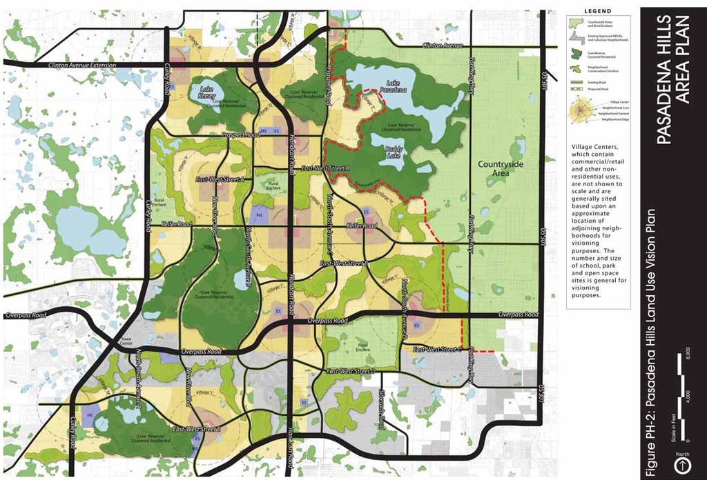
49
50 Figure PH-3: Open Space System Scale in Feet 0 3,500 7,000 PASADENA HILLS AREA PLAN PER COMP PLAN AMENDMENT LEGEND Pasadena Hills Boundary Countryside Area Adjacent City Boundaries Category 1 Wetlands Category 2 Wetlands Category 3 Wetlands Floodplain Naturally Vegetated Uplands Lakes North
51 Figure PH-4: 2050 Future Transportation Map Scale in Feet 0 3,500 7,000 PASADENA HILLS AREA PLAN PER COMP PLAN AMENDMENT North US 301 CLINTON AVENUE EXTENTION FORT KING HWY KIEFER ROAD EAST-WEST STREET C HIGHLAND HIGHLAND HIGHLAND HIGHLAND HIGHLAND HIGHLAND HIGHLAND HIGHLAND HIGHLAND BLVD BLVD BLVD BLVD BLVD BLVD BLVD BLVD BLVD EAST-WEST EAST-WEST EAST-WEST EAST-WEST EAST-WEST EAST-WEST EAST-WEST EAST-WEST EAST-WEST STREET STREET STREET STREET STREET STREET STREET STREET STREET B B B B B B B B B NORTH-SOUTH NORTH-SOUTH NORTH-SOUTH NORTH-SOUTH NORTH-SOUTH NORTH-SOUTH NORTH-SOUTH NORTH-SOUTH NORTH-SOUTH AVENUE AVENUE AVENUE AVENUE AVENUE AVENUE AVENUE AVENUE AVENUE C EAST-WEST STREET D SILVERADO ROAD HANDCART ROAD CLINTON AVENUE EXTENTION PROSPECT ROAD TYNDALL RD / EAST-WEST ST A ELAM ROAD NORTH-SOUTH AVENUE B CURLEY ROAD NEW NEW NEW NEW NEW NEW NEW NEW NEW RIVER RIVER RIVER RIVER RIVER RIVER RIVER RIVER RIVER BLVD BLVD BLVD BLVD BLVD BLVD BLVD BLVD BLVD OVERPASS ROAD NORTH-SOUTH AVENUE B NORTH-SOUTH AVENUE A EAST-WEST STREET E SR SR SR SR SR SR SR SR SR EXTENTION EXTENTION EXTENTION EXTENTION EXTENTION EXTENTION EXTENTION EXTENTION EXTENTION MCKENDREE ROAD LEGEND 6 lanes 4 lanes 2 lanes
52 Figure PH-5: Future Land Use Map Illustrating Core Reserve Overlay PASADENA HILLS Scale in Feet AREA PLAN 0 3,500 7,000 PER COMP PLAN AMENDMENT LEGEND Pasadena Hills Boundary Countryside Area Adjacent City Boundaries Denotes Change in FLU AG RES-6 AG/R RES-9 COM ROR CON TC EC VMU-1 IH MU VMU-2 VMU-3 P/SP CR-O RES-1 RES-3 VILLAGE B VILLAGE F VILLAGE K VILLAGE M VILLAGE L VILLAGE C VILLAGE D VILLAGE G VILLAGE J VILLAGE A VILLAGE E VILLAGE H VILLAGE I North
53 Figure PH-6: Pasadena Hills 2050 Future Land Use Map Scale in Feet 0 3,500 7,000 PASADENA HILLS AREA PLAN PER COMP PLAN AMENDMENT LEGEND Pasadena Hills Boundary Countryside Area Adjacent City Boundaries Denotes Change in FLU AG RES-6 AG/R RES-9 COM ROR IH TC MU VMU-1 P/SP RES-1 VMU-2 VMU-3 RES-3 VILLAGE B VILLAGE F VILLAGE K VILLAGE M VILLAGE L VILLAGE C VILLAGE D VILLAGE G VILLAGE J VILLAGE A VILLAGE E VILLAGE H VILLAGE I North
54 Figure PH-7: Village Location Map Scale in Feet 0 3,500 7,000 PASADENA HILLS AREA PLAN PER COMP PLAN AMENDMENT LEGEND Pasadena Hills Boundary Countryside Area Adjacent City Boundaries Category 1 Wetlands Category 2 Wetlands Category 3 Wetlands Floodplain Naturally Vegetated Uplands Water Bodies VILLAGE M TYPE 3 VILLAGE B TYPE 2B VILLAGE F TYPE 2B VILLAGE K TYPE 3 VILLAGE L TYPE 3 VILLAGE C TYPE 2A VILLAGE D TYPE 1 VILLAGE G TYPE 1 VILLAGE J TYPE 2A VILLAGE A TYPE 2A VILLAGE E TYPE 3 VILLAGE H TYPE 2B VILLAGE I TYPE 2A North
55 Figure PH-8: Village Separator or Rural Enclave Buffer Scale in Feet 0 3,500 7,000 PASADENA HILLS AREA PLAN PER COMP PLAN AMENDMENT US 301 CLINTON AVENUE EXTENTION FORT KING HWY KIEFER ROAD EAST-WEST STREET C HIGHLAND HIGHLAND HIGHLAND HIGHLAND HIGHLAND HIGHLAND HIGHLAND HIGHLAND HIGHLAND BLVD BLVD BLVD BLVD BLVD BLVD BLVD BLVD BLVD EAST-WEST EAST-WEST EAST-WEST EAST-WEST EAST-WEST EAST-WEST EAST-WEST EAST-WEST EAST-WEST STREET STREET STREET STREET STREET STREET STREET STREET STREET B B B B B B B B B NORTH-SOUTH NORTH-SOUTH NORTH-SOUTH NORTH-SOUTH NORTH-SOUTH NORTH-SOUTH NORTH-SOUTH NORTH-SOUTH NORTH-SOUTH AVENUE AVENUE AVENUE AVENUE AVENUE AVENUE AVENUE AVENUE AVENUE C EAST-WEST STREET D SILVERADO ROAD HANDCART ROAD CLINTON AVENUE EXTENTION PROSPECT ROAD TYNDALL RD / EAST-WEST ST A ELAM ROAD NORTH-SOUTH AVENUE B CURLEY ROAD NEW NEW NEW NEW NEW NEW NEW NEW NEW RIVER RIVER RIVER RIVER RIVER RIVER RIVER RIVER RIVER BLVD BLVD BLVD BLVD BLVD BLVD BLVD BLVD BLVD OVERPASS ROAD NORTH-SOUTH AVENUE B NORTH-SOUTH AVENUE A EAST-WEST STREET E SR SR SR SR SR SR SR SR SR EXTENTION EXTENTION EXTENTION EXTENTION EXTENTION EXTENTION EXTENTION EXTENTION EXTENTION LEGEND Separator / Buffer 6 lanes 4 lanes 2 lanes North MCKENDREE ROAD
56 8 Sidewalk 10 Parkway 4 Bike Lane 11 Lane 11 Lane Figure PH-9: Arterial Roadway Cross-Section 11 Lane 15 Median 11 Lane 11 Lane 11 Lane 4 Bike Lane 10 Parkway 8 Sidewalk 150 Village Separator as applicable PASADENA HILLS AREA PLAN
57 18 Sidewalk 7 Parking 11 Lane 11 Lane 11 Median Lane 11 Lane 7 Parking 18 Sidewalk 150 Village Separator as applicable Figure PH-10a1: Collector Urban Cross-Section PASADENA HILLS AREA PLAN
58 18 Sidewalk 7 11 Lane 11 Lane 7 Parking.5 Parking.5 18 Sidewalk 150 Village Separator as applicable Figure PH-10a2: Collector Urban Cross-Section PASADENA HILLS AREA PLAN
59 6 Sidewalk 10 Parkway 4 Bike Lane 11 Lane 11 Lane 11 Lane 11 Lane 11 Lane 4 Bike Lane 10 Parkway 12 Multi-Use Trail 150 Village Separator as applicable Figure PH-10b: Collector Neighborhood General Cross-Section PASADENA HILLS AREA PLAN
60 6 Sidewalk 10 Parkway 24 Street 10 Parkway 10 Multi Use Trail 150 Village Separator as applicable Figure PH-11: Local Roadway Cross-Section PASADENA HILLS AREA PLAN

61

62


 that provides for situations in which existing native landscape is not usable and does not provide adequate")
63 Notes: Illustration 1: Rural Enclave Buffer Illustration 2: Recommended 100 Foot Rural Enclave Plan View Option 1 Illustration 3: Recommended 100 Foot Rural Enclave Section View Option 1 Illustration 1 provides a complete view of the Rural Enclave Buffer, including the option of utilizing existing native vegetation and a landscaped berm for unvegetated areas. This buffer is designed to allow flexibility of utilizing existing native vegetation while requiring landscaping standards that effectively protect existing Rural Enclaves. Illustrations 2, 3, 4, and 5 provide illustrations of the optional plan and section views for the recommended 100 foot Rural Enclave. Illustrations 2 and 3 graphically illustrate an alternative buffer scenario (Option 1) that provides for situations in which existing native landscape is usable and provides adequate opacity. Supplemental landscape of the buffer is accomplished by creating landscape islands located on berms that are 6 feet tall and have a 3:1 slope. Native vegetation required includes 8 native canopy trees per 100 linear feet, in addition to supplemental understory shrubs. Retention is shown as optional within the first 30 feet of the buffer on the Pasadena Hills neighborhood adjacency. Retention within the buffer should be required by design to be non-polygonal and to mimic natural water features. Illustrations 4 and 5 graphically illustrate an alternative buffer scenario (Option 2) that provides for situations in which existing native landscape is not usable and does not provide adequate opacity, which is recommended to be at least 85%, or in which the extent of existing native vegetation is not adequate. In this case, the landscape of the buffer is accomplished by creating a continuous landscaped berm that is 6 feet tall and has a 3:1 slope. Native vegetation required includes 8 native canopy trees per 100 linear feet, in addition to supplemental understory shrubs. Retention is shown as optional within the first 30 feet of the buffer on the Pasadena Hills neighborhood adjacency. Retention within the buffer should be required by design to be non-polygonal and to mimic natural water features. Illustration 4: Recommended 100 Foot Rural Enclave Plan View Option 2 Illustration 5: Recommended 100 Foot Rural Enclave Section View Option 2 Figure PH-14: Rural Enclave Buffer Illustration PASADENA HILLS AREA PLAN
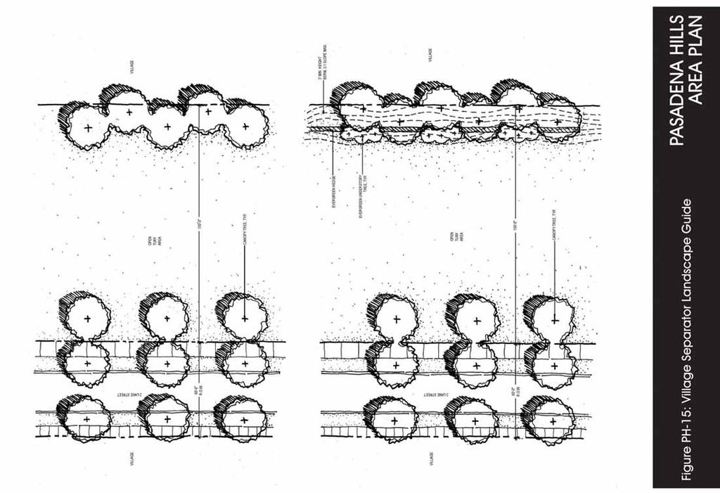
64
2025 COMPREHENSIVE PLAN PASCO COUNTY, FLORIDA
 GOAL FLU 6: PASADENA HILLS FUTURE LAND USE: PASADENA HILLS AREA PLAN GOALS, OBJECTIVES, AND POLICIES PASADENA HILLS AREA PLAN: OVERVIEW The Pasadena Hills Area Plan Goals, Objectives, and Policies are
ARTICLE 6: Special and Planned Development Districts
 ARTICLE 6: Special and Planned Development Districts 6-10 Traditional Neighborhood Development (TND) District 6-10.10 Purpose and Intent The Traditional Neighborhood Development (TND) District provides
COMMUNITY DESIGN. GOAL: Create livable and attractive communities. Intent
 COMMUNITY DESIGN Intent An attractive, well-designed County will attract quality development, instill civic pride, improve the visual character of the community, and create a strong, positive image for
AWH REPORT OF THE PLANNING AND DEVELOPMENT DEPARTMENT FOR APPLICATION FOR REZONING ORDINANCE TO PLANNED UNIT DEVELOPMENT
 AWH REPORT OF THE PLANNING AND DEVELOPMENT DEPARTMENT FOR APPLICATION FOR REZONING ORDINANCE TO PLANNED UNIT DEVELOPMENT MAY 8, 2014 The Planning and Development Department hereby forwards to the Planning
Dwelling Units Max 12 dwelling units per acre/min 8 dwelling units per acre. Development Mix 80% non residential/20% residential
 13. OSTEEN LOCAL PLAN Background: The Osteen Local Plan area is located in southwest Volusia County along the SR 415 corridor between Lemon Bluff Road and Acorn Lake Road and includes 3,990 acres. The
The transportation system in a community is an
 7 TRANSPORTATION The transportation system in a community is an important factor contributing to the quality of life of the residents. Without a sound transportation system to bring both goods and patrons
4.1.3 LAND USE CATEGORIES
 4.1.3 LAND USE CATEGORIES a. City Center District The City Center District incorporates the existing character and mix of uses in downtown Belmont to encourage redevelopment and new development in keeping
RECREATION AND OPEN SPACE ELEMENT GOALS, OBJECTIVES, AND POLICIES
 RECREATION AND OPEN SPACE ELEMENT GOALS, OBJECTIVES, AND POLICIES Goal 7 To provide park facilities, recreation programs, and open space resources that are safe, adequate, and accessible to all City residents,
Mitchell Ranch South MPUD Application for Master Planned Unit Development Approval Project Narrative. Introduction
 Mitchell Ranch South MPUD Application for Master Planned Unit Development Approval Project Narrative Introduction Mitchell Ranch South is a proposed single family (detached) residential development on
2040 LUP is a part of the Comprehensive Plan and carries the same legal authority. Economic Challenges
 1.1. Guiding Anchorage s Growth Where will new residents settle over the next two decades? Where will people work, shop, and play? Will there be enough room to grow? How will Anchorage look? Will growth
LAND USE ELEMENT. Purpose. General Goals & Policies
 LAND USE ELEMENT Purpose This Land Use Element contains the goals and policies necessary to support the City s responsibility for managing land resources and guiding development through implementing regulations,
ARTICLE 13 STREETS General
 ARTICLE 13 STREETS 13.1 General Streets shall be designed to suit their functions. Many streets have purposes other than vehicular traffic. As an alternative to current N.C. Department of Transportation
CHAPTER 7: VISION AND ACTION STATEMENTS. Noble 2025 Vision Statement
 CHAPTER 7: VISION AND ACTION STATEMENTS This chapter presents the vision, policy and action statements that transform the comprehensive planning study, an analysis of Noble s past, future trends and community
Gold Line Bus Rapid Transit Transit Oriented Development (BRTOD) Helmo Station Area Plan
 Helmo Station Area Plan") Appendix F Gold Line Bus Rapid Transit Transit Oriented Development (BRTOD) Helmo Station Area Plan Introduction and Purpose of the Plan The Gold Line Bus Rapid Transit facility is an eleven-mile dedicated
Appendix F Gold Line Bus Rapid Transit Transit Oriented Development (BRTOD) Helmo Station Area Plan Introduction and Purpose of the Plan The Gold Line Bus Rapid Transit facility is an eleven-mile dedicated
[THIS PAGE INTENTIONALLY LEFT BLANK]
![[THIS PAGE INTENTIONALLY LEFT BLANK]](/thumbs/77/76526040.jpg "[THIS PAGE INTENTIONALLY LEFT BLANK]") 1-1 LAND USE [THIS PAGE INTENTIONALLY LEFT BLANK] TABLE OF CONTENTS INTRODUCTION... 7 1-1. GOAL: TO DEVELOP AND MAINTAIN A WELL-BALANCED COMMUNITY WITH A VARIETY OF LAND USES THAT ARE COMPATIBLE WITH EACH
1-1 LAND USE [THIS PAGE INTENTIONALLY LEFT BLANK] TABLE OF CONTENTS INTRODUCTION... 7 1-1. GOAL: TO DEVELOP AND MAINTAIN A WELL-BALANCED COMMUNITY WITH A VARIETY OF LAND USES THAT ARE COMPATIBLE WITH EACH
Planned Residential Neighborhoods Land Use Goals
 Planned Residential Neighborhoods Land Use Goals Issue: Guidelines that provide for diverse high quality residential areas that include a variety of housing styles and layouts are needed. Goal 1: Create
Baumgarten MPUD. Exhibit 3 Evaluation Criteria
 Pursuant to LDC subsections 10.02.13 B, 10.02.08 F and Chapter 3 G. of the Administrative Code, staff s analysis and recommendation to the Planning Commission, and the Planning Commission s recommendation
open public hearing and allow public comment request to continue LPA public hearing to January 16, 2014 at 10:30 am
 TODAY S AGENDA Work Session LPA Transmittal Public Hearing open public hearing and allow public comment request to continue LPA public hearing to January 16, 2014 at 10:30 am staff will issue a recommendation
Ten Mile Creek Planning Area
 PLANNING AREA POLICIES TEN MILE CREEK Ten Mile Creek Planning Area Location and Context The Ten Mile Creek Planning Area ( Ten Mile Creek area ) is located south of the current Boise AOCI, generally south
Applicant Name Phone / Fax / Address City State Zip Code . Property Owner Phone / Fax / Address City State Zip Code
 Master Development Plan Application Community Development Department City of Redmond 411 SW 9 th Street Redmond, Oregon 97756 541-923-7721 541-548-0706 FAX Master Development Plan Fee $38,862.52 File Number
3. VISION AND GOALS. Vision Statement. Goals, Objectives and Policies
 Vision Statement Queen Creek s interconnected network of parks, trails, open spaces and recreation opportunities provide safe and diverse activities and programs that sustain its unique, small town, equestrian
Glenborough at Easton Land Use Master Plan
 Implementation 114 9.0 IMPLEMENTATION 9.1 OVERVIEW This chapter summarizes the administrative procedures necessary to implement the proposed land use plan, infrastructure improvements, development standards,
Town of Washington Master Plan & Regulatory Audit: Interim Results
 Town of Washington Master Plan & Regulatory Audit: Interim Results May 20, 2008 Presented by: 30 Bank Street Lebanon, NH 03766 www.uvlsrpc.org Introduction & Purpose Compare the Master Plan to the regulations
CHAPTER 12 IMPLEMENTATION
 CHAPTER 12 IMPLEMENTATION The 2010 Town of Denton Comprehensive Plan is intended to capture a vision of the future of Denton. As such, it provides a basis for a wide variety of public and private actions
2.0 AREA PLANS. Lakeside Business District. Lakeside Business District Land Use Categories:
 Lakeside Business District Lakeside Business District Land Use Categories: Campus Commercial Campus Commercial means a mixture of uses which includes corporate offices, office parks, hotels, commercial,
Narcoossee Roadway Corridor
 Community Meeting Narcoossee Roadway Corridor April 5, 2012 Meeting Agenda Purpose of Meeting Continuation of Study Update Process (Previous Meetings Oct. & Nov., 2011) Tonight s Objective Review Proposals
BROOKHILL NEIGHBORHOOD MODEL ZONING MAP AMENDMENT PREFACE TO APPLICATION
 BROOKHILL NEIGHBORHOOD MODEL ZONING MAP AMENDMENT PREFACE TO APPLICATION June 15, 2015 Revised: August 1, 2016 I. VISION Brookhill is a proposed community based upon the principles of Albemarle County
Chapter IV: Development Pattern
 Chapter IV: Development Pattern Introduction The 2002 Prince George s County Approved General Plan designates three growth policy tiers Developed, Developing, and Rural as well as three center designations
AREASTRUCTURE PLAN AMENDMENT COCHRANE NORTH
 AREASTRUCTURE PLAN AMENDMENT COCHRANE NORTH In order to implement the vision outlined in the Conceptual Scheme, the following three amendments to the Cochrane North ASP are proposed: 1. Allow commercial
Behnke Ranch Property, Pasco County: Master Plan Development Approach
 February 24, 2014 , Pasco County: Master Plan Development Approach Location & Program The (Legacy PUD) is located in southwest Pasco County along State Road 54 approximately 1.5 miles west of the Suncoast
Future Land Use and Transportation
 Planning & Zoning Board Workshop Comprehensive Plan for Village of Estero Future Land Use and Transportation April 6, 2017 January Kick-off Meeting Public Input What do you like about Estero? Location
ARTICLE 13 STREETS General
 ARTICLE 13 STREETS 13.1 General Streets shall be designed to suit their functions. Many streets have purposes other than vehicular traffic. As an alternative to current N.C. Department of Transportation
ALBEMARLE COUNTY CODE CHAPTER 18 ZONING SECTION 20A NEIGHBORHOOD MODEL - NMD
 CHAPTER 18 ZONING SECTION 20A NEIGHBORHOOD MODEL - NMD Sections: 20A.1 PURPOSE AND INTENT 20A.2 STATUS AS A PLANNED DEVELOPMENT DISTRICT 20A.5 CODES OF DEVELOPMENT 20A.6 PERMITTED USES 20A.7 RESIDENTIAL
CHAPTER 1. Ms. Guajardo s Class - Central Elementary CH 1 1
 INTRODUCTION CHAPTER 1 Ms. Guajardo s Class - Central Elementary CH 1 1 1.1 SETTING South Centre City is a linear corridor south of Downtown Escondido paralleling Centre City Parkway and South Escondido
SAN RAFAEL GENERAL PLAN 2040 INTRODUCTION AND OVERVIEW
 SAN RAFAEL GENERAL PLAN 2040 INTRODUCTION AND OVERVIEW Steering Committee Presentation February 14, 2018 Purpose of General Plan Guide land use and development decisions Coordinate transportation, infrastructure,
SECTION II SECTION II STATEMENT OF GOALS, OBJECTIVES, PRINCIPLES, ASSUMPTIONS, POLICIES AND STANDARDS
 STATEMENT OF GOALS, OBJECTIVES, PRINCIPLES, ASSUMPTIONS, POLICIES AND STANDARDS 1 2 STATEMENT OF GOALS, OBJECTIVES, PRINCIPLES, ASSUMPTIONS, POLICIES AND STANDARDS INTRODUCTION The New Jersey Municipal
ORDINANCE WHEREAS, this Ordinance is consistent with the City of Winter Garden Comprehensive Plan; and
 ORDINANCE 17-06 AN ORDINANCE OF THE CITY COMMISSION OF THE CITY OF WINTER GARDEN, FLORIDA, CREATING ARTICLE XIV OF CHAPTER 118 OF THE CITY OF WINTER GARDEN CODE OF ORDINANCES PROVIDING FOR THE EAST PLANT
Staff Report and Recommendation
 Community Planning and Development Planning Services 201 W. Colfax Ave., Dept. 205 Denver, CO 80202 p: 720.865.2915 f: 720.865.3052 www.denvergov.org/cpd TO: City Council Neighborhoods and Planning Committee
Section 9 NEIGHBORHOOD DESIGN
 Section 9 NEIGHBORHOOD DESIGN City of Lancaster Comprehensive Plan D u n k i n, S e f k o & A s s o c i a t e s, I n c. NEIGHBORHOOD DESIGN INTRODUCTION There are many ways in which a neighborhood can
Exhibit A. 8:9 Scuffletown Rural Conservation District
 Exhibit A 8:9 Scuffletown Rural Conservation District 8:9.1 Intent and Purpose The Scuffletown Rural Conservation (SRC) District is intended to provide for residential development that supports the development
DEVELOPMENT FRAMEWORK POST 2030 LAND USE PLAN INTRODUCTION
 INTRODUCTION Oak Grove s Comprehensive Plan identifies a future Metropolitan Urban Service Area (MUSA). The Metropolitan Council does not anticipate extending utilities to this area prior to 2030. The
9 th Street Sub Area Plan
 9 th Street Sub Area Plan In the 1990 s, when the Township prepared the last Master Plan, the 9 th Street corridor was studied as part of a larger 9 th Street Focus Area that included the West Main Street
G. RECREATION AND OPEN SPACE ELEMENT. The following summarizes the Recreation and Open Space Element:
 G. RECREATION AND OPEN SPACE ELEMENT The purpose of the Element is to provide the framework and direction for a comprehensive system of public and private sites for recreation, including, but not limited
TREASURE COAST REGIONAL PLANNING COUNCIL M E M O R A N D U M. To: Council Members AGENDA ITEM 5I
 TREASURE COAST REGIONAL PLANNING COUNCIL M E M O R A N D U M To: Council Members AGENDA ITEM 5I From: Date: Subject: Staff December 12, 2008 Council Meeting Local Government Comprehensive Plan Review Town
LAND USE GOALS, OBJECTIVES AND POLICIES. Goal 1: [L] (EFF. 7/16/90)
![LAND USE GOALS, OBJECTIVES AND POLICIES. Goal 1: [L] (EFF. 7/16/90)](/thumbs/88/115018937.jpg "LAND USE GOALS, OBJECTIVES AND POLICIES. Goal 1: [L] (EFF. 7/16/90)") LAND USE GOALS, OBJECTIVES AND POLICIES Goal 1: [L] (EFF. 7/16/90) The Comprehensive Plan shall protect and enhance the quality of life in this community by providing economically sound educational, employment,
LAND USE GOALS, OBJECTIVES AND POLICIES Goal 1: [L] (EFF. 7/16/90) The Comprehensive Plan shall protect and enhance the quality of life in this community by providing economically sound educational, employment,
City of Redmond. Urban Holding Area Master Planning Requirements and Approval Process
 City of Redmond Urban Holding Area Master Planning Requirements and Approval Process June 21, 2006 City of Redmond: Urban Holding Area Master Planning Requirements and Approval Process Table of Contents
NEW CASTLE COUNTY S ZONING DISTRICTS
 NEW CASTLE COUNTY S ZONING DISTRICTS This is general information about New Castle County s zoning districts. The information included is by no means exhaustive or complete. Before designing plans to develop
THE POLICY FRAMEWORK FOR WALKABLE COMMUNITIES. Community Technical Assistance Program Building Active Communities Institute March 2016
 THE POLICY FRAMEWORK FOR WALKABLE COMMUNITIES Community Technical Assistance Program Building Active Communities Institute March 2016 ACTIVE COMMUNITIES BACK THEN ACTIVE COMMUNITIES BACK THEN Lifestyle
Osceola County Board of County Commissioners 1 Courthouse Square, Suite 1100 Kissimmee, FL
 1/10/11 Item Number DRI08-0006 Osceola County Board of County Commissioners 1 Courthouse Square, Suite 1100 Kissimmee, FL 34741 407-742-0200 Applicant & Owner Center Lake Properties, LLLP and Formally
Appendix C: Interim Mixed-Use Evaluation Criteria
 Appendix C: Interim Mixed-Use Evaluation Criteria C-1 Appendix C: Interim Mixed-Use Evaluation Criteria PURPOSE: The implementation of numerous policies contained within the Master Plan hinges on the creation
SECTION UNIFIED DEVELOPMENT ORDINANCE SECTION Part 1 Ordinance. ARTICLE 1 Zoning Districts
 SECTION 1-100 UNIFIED DEVELOPMENT ORDINANCE SECTION 1-300 Part 1 Ordinance SECTION 1-100. Introduction. ARTICLE 1 Zoning Districts Crystal Lake strives to maintain a balance of various land uses for a
Asbury Chapel Subdivision Sketch Plan
 Asbury Chapel Subdivision Sketch Plan PART 1: PROJECT SUMMARY Applicant: NVR Inc. Project Size: +/- 76.13 acres Parcel Numbers: 02101112,02116101,02116112, 02116113 Current Zoning: Transitional Residential
CHAPTER 3 VISION, GOALS, & PLANNING PRINCIPLES. City of Greensburg Comprehensive Plan. Introduction. Vision Statement. Growth Management Goals.
 CHAPTER 3 VISION, GOALS, & PLANNING PRINCIPLES Introduction The Greensburg Comprehensive Plan is intended as a working community document. A combination of long and short-term goals, this document is intended
Draft Stillwater 2030 Comprehensive Plan- Goals and Policies
 Draft Stillwater 2030 Comprehensive Plan- Goals and Policies Instructions- Review each goal and policy and discuss with group any changes, deletions for additions to the list using your groups pen. Keep
Review of Opportunity Area C Draft Comprehensive Plan and Draft BOS Follow-On Motions. Special Working Group Meeting March 4, 2015
 Review of Opportunity Area C Draft Comprehensive Plan and Draft BOS Follow-On Motions Special Working Group Meeting March 4, 2015 The slides that follow identify where the draft Comprehensive Plan has
4 Sustainability and Growth Management
 4 Sustainability and Growth Management Introduction Traditionally, has assumed growth and development with limited consideration for the long-term negative social, environmental or economic impacts on
This page intentionally blank.
 This page intentionally blank. Parks, Recreation, and Open Space Chapter Relationship to Vision Vision Parks, Recreation and Open Space Chapter Concepts County Government. County government that is accountable
Selected Area Study. Vision Plan Draft
 East Polk County Selected Area Study Draft 10.30.08 Contents Guiding Principles...4 Context Conclusions...5 Current Context...8 Scenarios...9 Scenario: Status Quo...10 Scenario: Connected & Directed Growth...12
Regional Context Statement
 Regional Context Statement REGIONAL CONTEXT STATEMENT 3. REGIONAL CONTEXT STATEMENT In 1995, the Provincial Government passed into law the Growth Strategies Act. The purpose of this provincial initiative
Chapter 12 GENERAL STRATEGY
 GOAL: Vision: Section 163.3245, Florida Statutes "supports innovative and flexible planning and development strategies" through the Sector Plan process as a tool to encourage long-term planning for conservation,
Secrest Short Cut and Monroe Expressway Small Area Plan AUGUST 29, 2018
 Secrest Short Cut and Monroe Expressway Small Area Plan AUGUST 29, 2018 Background and Process Monroe Expressway will be open by the end of 2018 Union County and Indian Trail identified a need to revisit
Westwind Developments Ltd. PIONEER LANDS AREA STRUCTURE PLAN - PROPOSED AMENDMENT
 FEBRUARY 2013 TABLE OF CONTENTS 1.0 BACKGROUND... 1 1.1 Amendment... 1 2.0 LOCATION & CONTEXT... 2 2.1 Land Ownership... 2 3.0 POLICY CONTEXT... 3 3.1 Municipal Development Plan... 3 3.2 Capital Region
City of Hermosa Beach Administrative Policy #
 City of Hermosa Beach Administrative Policy # SUBJECT: Living Streets Policy Date: Approved by: City Council Authority: Public Works Department & Community Development Department Mayor, PURPOSE The City
Westbound: A One-day Exploration of Growth
 Westbound: A One-day Exploration of Growth Frog Pond Area 2018 UGB Expansion Proposal June 13, 2018 Growing Out: UGB Asks Four cities submitted proposals to expand greater Portland s urban footprint by
Major Subdivision Sketch Plan Checklist
 This checklist provides specific requirements that are apart of the Sketch process. The entire process is described by the Huntersville Subdivision Review Process which details all the submittal and resubmittal
Silverdale Regional Center
 Silverdale Regional Center Vision for Silverdale Regional Center The Silverdale Regional Center Plan (Plan) will guide the evolution of the Silverdale Regional Center from a collection of strip malls and
EXISTING COMPREHENSIVE PLAN
 EXISTING COMPREHENSIVE PLAN Town Center Land Use Element: V. LAND USE POLICIES Town Center Mercer Island's business district vision as described in "Your Mercer Island Citizen-Designed Downtown" was an
Outline Plan in Belvedere (Ward 9) at Street SE, LOC (OP)
 at Street SE, LOC (OP)") 2018 October 04 Page 1 of 12 EXECUTIVE SUMMARY This outline plan application was submitted by B&A Planning Group on 2016 July 15, on behalf of Tristar Communities Inc. for 50.14 hectares (123.89 acres)
2018 October 04 Page 1 of 12 EXECUTIVE SUMMARY This outline plan application was submitted by B&A Planning Group on 2016 July 15, on behalf of Tristar Communities Inc. for 50.14 hectares (123.89 acres)
Rural Land Use Designations Kittitas County December 6, 2007 Draft
 KITTITAS COUNTY COMMUNITY DEVELOPMENT SERVICES 411 N. Ruby St., Suite 2, Ellensburg, WA 98926 CDS@CO.KITTITAS.WA.US Office (509) 962-7506 Fax (509) 962-7682 Rural Land Use Designations Kittitas County
CITY OF PUYALLUP. Background. Development Services
 CITY OF PUYALLUP Development Services 333 South Meridian Puyallup WA 98371 To: City Council From: Katie Baker, AICP, Planning Division Re: South Hill Neighborhood Plan Adoption Date: (Meeting date: February
Executive Summary. NY 7 / NY 2 Corridor
 Executive Summary NY 7 / NY 2 Corridor Transportation and Land Use Study December 2005 Prepared for: Town of Colonie Capital District Transportation Committee Prepared by: Introduction: Land use decisions
IMPLEMENTATION STRATEGIES. In This Chapter. Goals & Strategies 182 Project List 183 Future Land Use 186 CHAPTER 11 IMPLEMENTATION STRATEGIES
 In This Chapter Goals & Strategies 182 Project List 183 Future Land Use 186 11 IMPLEMENTATION STRATEGIES NORTH AUGUSTA, SC 2017 COMPREHENSIVE PLAN 179 Individual commitment to a group effort that is what
KASPER. City of Georgetown, Texas PUD Planned Unit Development. December 30, 2015 Revised January 27, 2016
 KASPER City of Georgetown, Texas PUD Planned Unit Development December 30, 2015 Revised January 27, 2016 Applicant: Sentinel Land Company, LLC 4910 Campus Drive Newport Beach, CA Prepared by: SEC Planning
ARTICLE IV: DEVELOPMENT STANDARDS 404 MASTER PLANNING
 IV 13 404 MASTER PLANNING Master Planning through the Site Analysis (Master Planning Site Analysis) or Planned Development (Master Planning Planned Development) is provided to encourage development which
CITY OF TARPON SPRINGS DCA#11-1AR
 Agenda Item #3.H.2 05/09/11 TAMPA BAY REGIONAL PLANNING COUNCIL LOCAL GOVERNMENT COMPREHENSIVE PLAN ADOPTED AMENDMENT REPORT CITY OF TARPON SPRINGS DCA#11-1AR 1 ADOPTED WITH THE FOLLOWING CHANGES: Ordinance
BRANAN FIELD MASTER PLAN
 EXHIBIT L BRANAN FIELD MASTER PLAN GOALS, OBJECTIVES AND POLICIES Table of Contents Section Page 1. Future Land Use Element... 1 2. Transportation Element... 17 3. Recreation and Open Space Element...
TREASURE COAST REGIONAL PLANNING COUNCIL M E M O R A N D U M. To: Council Members AGENDA ITEM 5H
 TREASURE COAST REGIONAL PLANNING COUNCIL M E M O R A N D U M To: Council Members AGENDA ITEM 5H From: Date: Subject: Staff October 17, 2008 Council Meeting Local Government Comprehensive Plan Review Draft
4. Shape Transitions. 4. Shape Transitions
 4. Shape Transitions 49 Zoning District Policies Overall Intent: Maintain neighborhood character by creating compatible transitions that minimize land use conflicts. Strategy: Define the character of zoning
Municipal Development Plan Update Urban Service Area and Hamlets
 ENCLOSURE 1 Municipal Development Plan Update Urban Service Area and Hamlets Priorities Committee January 24, 2017 MUNICIPAL DEVELOPMENT PLAN UPDATE SHAPING OUR FUTURE MDP Update - Agenda MDP Update Public
2018 Northampton Township Comprehensive Plan
 2018 BUCKS COUNTY, PENNSYLVANIA What is a? A comprehensive plan is a municipality s main policy document that details the collective vision for the future, the historic, environmental, and cultural facilities
CHAPTER 22 Rural Open Space Community Developments
 CHAPTER 22 Rural Open Space Community Developments Section 22.1 Description and Purpose The intent of this Chapter is to offer property owners an alternative to traditional zoning requirements for rural
SPRINGHILL LAKE TRANSIT VILLAGE
 Greenbelt Metro Area Sector Plan - Subarea Design Policies and Guidelines - Springhill Lake Transit Village 113 SPRINGHILL LAKE TRANSIT VILLAGE Residential Neighborhood and Village Center CONCEPT Springhill
ATTACHMENT A. SILVERDALE DESIGN STANDARDS Amendments to the Waaga Way Town Center Chapter
 ATTACHMENT A SILVERDALE DESIGN STANDARDS Amendments to the Waaga Way Town Center Chapter Chapter 10. Waaga Way Town Center 10.1 Physical Identity Elements & Opportunities The Waaga Way Town Center includes
Steering Committee Meeting
 Neighborhood Planning Initiative NPI EAST CENTRAL AREA PLAN Steering Committee Meeting November 9, 2017 6:00PM 8:00PM Tears McFarlane House East Central Area Plan Steering Committee Meeting 11/9/17 AGENDA
Improve Neighborhood Design and Reduce Non Point Source Water Pollution
 HOW TO Planning Guide Improve Neighborhood Design and Reduce Non Point Source Water Pollution This document was funded by a grant from the New Hampshire Coastal Program with funding from the National Oceanic
Land Use Amendment in Southwood (Ward 11) at and Elbow Drive SW, LOC
 at and Elbow Drive SW, LOC") 2018 November 15 Page 1 of 10 EXECUTIVE SUMMARY This land use amendment application was submitted by Rick Balbi Architect on 2017 August 31 on behalf of Sable Developments Ltd, and with authorization from
2018 November 15 Page 1 of 10 EXECUTIVE SUMMARY This land use amendment application was submitted by Rick Balbi Architect on 2017 August 31 on behalf of Sable Developments Ltd, and with authorization from
S o u t h C e n t r a l O u t l i n e P l a n. Leduc Business Park. North Leduc Industrial Area Structure Plan C it y of Led u c.
 Leduc Business Park North Leduc Industrial Area Structure Plan C it y of Led u c Prepared for Farm Air Properties Inc. January, 2007 Table of Contents Page Number 1.0 Purpose of Plan and Definition of
BRANAN FIELD MASTER PLAN
 EXHIBIT L BRANAN FIELD MASTER PLAN GOALS, OBJECTIVES AND POLICIES Table of Contents Section Page 1. Future Land Use Element...1 2. Transportation Element...17 3. Recreation and Open Space Element...21
ARTICLE V PLANNED UNIT DEVELOPMENT DISTRICT
 ARTICLE V PLANNED UNIT DEVELOPMENT DISTRICT A. Purpose and Objective The Planned Unit Development (PUD) procedure provides a flexible land use and design regulation through the use of performance criteria
CITY OF EUSTIS COMPREHENSIVE PLAN 2035
 FUTURE LAND USE GOALS, OBJECTIVES AND POLICIES EXHIBIT A GOAL FLU 1: DEVELOPMENT FRAMEWORK Implement a land use and development framework that will: Promote diversified economic development; Protect and
SECTION E. Realizing the Plan
 SECTION E Realizing the Plan 60 DESIGN REGINA - OFFICIAL COMMUNITY PLAN SECTION E Realizing the Plan Design Regina has been an ambitious plan-making exercise, with a high level of community, stakeholder,
Complete Neighbourhood Guidelines Review Tool
 Complete Neighbourhood Guidelines Review Tool Prepared By: City of Regina Planning Department October 2014 Page 1 of 14 Community Development Review Checklist for Secondary Plans and Concept Plans The
The following rules shall be used to determine the precise location of any zone boundary shown on the Official Zoning Map of Auburn:
 ARTICLE III. ESTABLISHMENT OF ZONING DISTRICTS Section 300. Establishment of Zoning Districts. The City of Auburn, Alabama is hereby divided into zoning districts of such number and character as are necessary
Cobb County Design Guidelines Mableton Parkway & Veterans Memorial Highway Community Design Workshop January 12, 2017
 Community Design Workshop January 12, 2017 Agenda Opening Remarks / Introductions Scope of Work Existing Conditions Key Issues / Opportunities VPS Summary Draft Vision & Goal Statement Implementation Concepts
Planning Commission April 4, 2013 BOCC Workshop Page 1
 Planning Commission April 4, 2013 BOCC Workshop Page 1 Planning Commission April 4, 2013 BOCC Workshop Page 2 Planning Commission April 4, 2013 BOCC Workshop Page 3 Planning Commission April 4, 2013 BOCC
DISCUSSION ON VACAVILLE S2 INVESTORS PROPERTY IN URBAN RESERVE
 Agenda Item No. 9C April 25, 2017 TO: FROM: SUBJECT: Honorable Mayor and City Council Attention: Jeremy Craig, Interim City Manager Barton Brierley, AICP, Community Development Director (Staff Contact:
Planned Development Review Revisions (Project No. PLNPCM )
") Planned Development Review Revisions (Project No. PLNPCM2014-00139) Standard residential development Planned Development Example: Smaller lot sizes than what is allowed to create open space amenity. What
Planned Development Review Revisions (Project No. PLNPCM2014-00139) Standard residential development Planned Development Example: Smaller lot sizes than what is allowed to create open space amenity. What
Policies and Code Intent Sections Related to Town Center
 Policies and Code Intent Sections Related to Town Center The Town Center Vision is scattered throughout the Comprehensive Plan, development code and the 1994 Town Center Plan. What follows are sections
Town of Peru Comprehensive Plan Executive Summary
 Town of Peru Comprehensive Plan Executive Communities that plan grow by choice, not by chance. A plan makes growth thoughtful, understandable, and predictable. A plan shows that a community is managing
The Five Components of the McLoughlin Area Plan
 The Five Components of the McLoughlin Area Plan This documents contains the complete language of the five components of the McLoughlin Area Plan: The Vision Statement The Values The Guiding Principles