FOR SALE. 3.2-Acres Development Land PRESENTING. $1,390,000 Ballenger Creek Pike, Frederick, Maryland Location:
|
|
|
- Meagan McKinney
- 5 years ago
- Views:
Transcription

1 FOR SALE $1,390,000 Ballenger Creek Pike, Frederick, Maryland Acres Development Land Great location with frontage on Ballenger Creek Pike. These 3.2 acres are situated next to Tuscarora High School and Ballenger Creek Park and adjacent to the new Ballenger Run Subdivision. Only 5 minutes to MD-85 and I-270. Close to restaurants, shopping, hospitality and entertainment. Please contact Rocky Mackintosh or Ashleigh Kiggans to tour this property by appointment only. PRESENTING Location: Ballenger Creek Pike, Frederick, Maryland Legal: Tax Map 0086, Parcels 0049, 0050, 0161, 0171, 0273 Zoning: Acreage: Utilities: Frederick County: A The purpose of the Agricultural District (A) is to preserve productive agricultural land and the character and quality of the rural environment and to prevent urbanization where roads and other public facilities are scaled to meet only rural needs. ** Frederick County Comprehensive Plan land use plan designation for Medium Density Residential Approx. 3.2 Acres Public water and sewer Contact: Rocky Mackintosh, Broker Ashleigh Kiggans, Vice President Office: ext. 202 Office: ext. 205 Mobile: Mobile: rocky@macroltd.com ashleigh@macroltd.com

2 LOCATION MAP
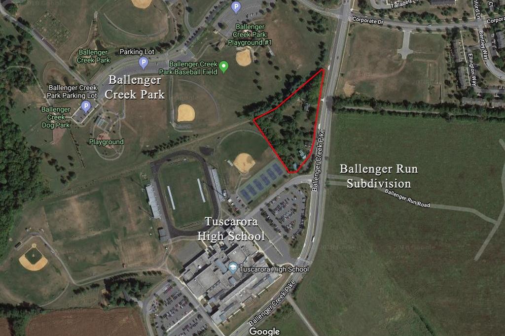
3 AERIAL

4 ZONING ACREAGE
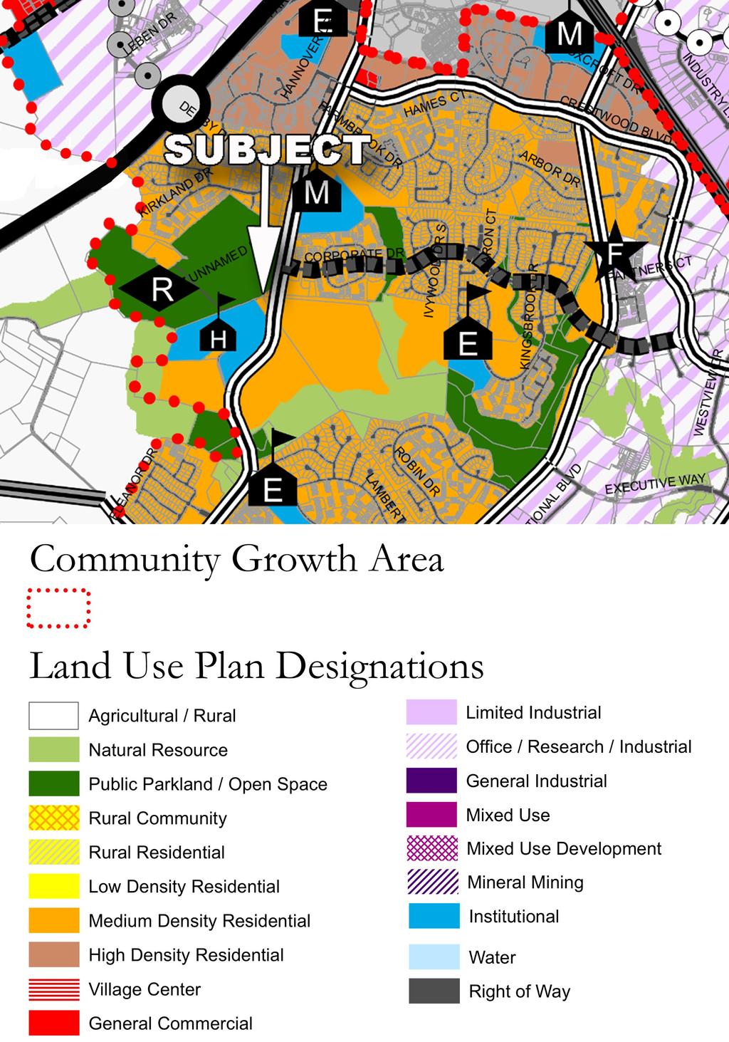
5 COMPREHENSIVE PLAN
6 ZONING Frederick County Zoning Agricultural District (A) The purpose of the Agricultural District (A) is to preserve productive agricultural land and the character and quality of the rural environment and to prevent urbanization where roads and other public facilities are scaled to meet only rural needs. Possible usage under zoning (permitted and some permitted use subject to site dev. plan approval) includes, but not limited to: Agricultural Activities Apiary Agricultural Value Added Processing Agritourism Expertise Nursery Retail or Wholesale Farm Winery Farm Winery Tasting Room Farm Brewery Farm Brewery Tasting Room Limited/Commercial Roadside Stand Forestry Sawmill Single-Family Detached Two-Family Dwelling Mobile Homes Caretaker Residence in Conjunction with Permitted Use Accessory Apartment Bed and Breakfast Farm Equipment Sales or Service Feed and Grain Mill Communication Towers Limited Landscape Contractor Landscape Contractor Country Inn Agricultural Products Processing School Bus Parking Recreational Vehicle Storage Facility Animal Hospital or Veterinary Clinic Kennel Auction Sales Animals Outdoor Sports Recreation Facility Rodeo Cemetery/Memorial Gardens Shooting Range/Club Trap, Skeet, Rifle, Archery Aircraft Landing and Storage Areas, Private Aircraft Landing and Storage Areas, Private Commercial Use Tent Campground Rustic Retreat/Camp/Outdoor Club Child Care Center/Nursery School Civic Community Center Civic Service Clubs Group Homes, Small Private Group Home, Large Place of Worship Private School Community Fire and Rescue Service Public School Nongovernmental Utility Borrow Pit Operations Industrial Waste Landfill Limited Wood Waste Recycling Facility Sludge Pit And more...
Annual lease of the tillable acreage for crops (soybeans and/or corn).
.") FOR SALE $895,000.00 11201 Hill Road, Woodsboro, Maryland 21798 Crop Farm with Subdivision Potential PRESENTING Location: 11201 Hill Road, Woodsboro, MD 132.2064 acre crop farm with extraordinary views,
FOR SALE $895,000.00 11201 Hill Road, Woodsboro, Maryland 21798 Crop Farm with Subdivision Potential PRESENTING Location: 11201 Hill Road, Woodsboro, MD 132.2064 acre crop farm with extraordinary views,
FOR SALE 21 acres of Limited Industrial Land 6.4 acres of Commercial Land Baldwin Road West, Monrovia, Maryland 21770
 21 acres of Limited Industrial Land 6.4 acres of Commercial Land, I-70 Frontage and Visibility Established Industrial and Commercial Area PRESENTING LOCATION: Intersection of and Green Valley Road LEGAL:
FOR LEASE. Spring Ridge Shopping Center PRESENTING. Call For Pricing Spring Ridge Parkway, Frederick, Maryland Location:
 FOR LEASE Call For Pricing Spring Ridge Parkway, Frederick, Maryland 21701 Spring Ridge Shopping Center Located at the entrance of Spring Ridge Community, the Spring Ridge Shopping Center serves the community
FOR LEASE. Ideal Downtown Frederick Location for Retail, Restaurant or Fitness PRESENTING
 FOR LEASE CALL FOR PRICING 125 East All Saints Street, Frederick, Maryland 21701 Ideal Downtown Frederick Location for Retail, Restaurant or Fitness Here is where the downtown action is today and will
FOR LEASE. Downtown Frederick Retail/Office Space for Lease. Property Details PRESENTING
 FOR LEASE $3,500/SF (Modified Gross Lease) 630 North Market Street, 1 st Floor, Frederick, Maryland 21701 PRESENTING Location: 630 North Market Street, 1 st Floor, Frederick, MD 21701 Downtown Frederick
Those uses will be allowed which are compatible with these overall objectives. 4. Public and private parks and playgrounds.
 CHAPTER 500. SECTION 503. ZONING STANDARDS A-C AGRICULTURAL DISTRICT 503.1. Purpose The purpose of the A-C Agricultural District is to preserve the rural and open character of various lands within the
Zoning Rewrite Implementation Worksession #3. Industrial Zones April 11, 2013
 Zoning Rewrite Implementation Worksession #3 Industrial Zones April 11, 2013 1 Industrial Zones Current I-1 942.19 acres 0.33% Current I-2 757.36 acres 0.27% Current I-3 (floating) 970.29 acres 0.34% Current
7. Maintaining small animals and fowl for the occupant's use or need only, not to exceed a ratio of twenty (20) per acre.
 per acre.") CHAPTER 500. SECTION 505. ZONING STANDARDS A-R AGRICULTURAL-RESIDENTIAL DISTRICT 505.1. Purpose The purpose of the A-R Agricultural-Residential District is to allow the development of relatively large
CHAPTER 500. SECTION 505. ZONING STANDARDS A-R AGRICULTURAL-RESIDENTIAL DISTRICT 505.1. Purpose The purpose of the A-R Agricultural-Residential District is to allow the development of relatively large
7. Maintaining small animals and fowl for the occupant's use or need only, not to exceed a ratio of twenty (20) per acre.
 per acre.") CHAPTER 500. SECTION 506. ZONING STANDARDS AR-1 AGRICULTURAL-RESIDENTIAL 506.1. Purpose The purpose of the AR-1 Agricultural-Residential District is to allow the development of relatively large tracts
CHAPTER 500. SECTION 506. ZONING STANDARDS AR-1 AGRICULTURAL-RESIDENTIAL 506.1. Purpose The purpose of the AR-1 Agricultural-Residential District is to allow the development of relatively large tracts
Town of Liberty, NY COMPREHENSIVE PLAN & ZONING UPDATES
 Town of Liberty, NY S Public Informational Meeting October 4, 2016 High School Auditorium Welcome Thank you for coming tonight. Agenda Part I Overview of Proposed Changes What is Being Prepared Anticipated
Electric (208/120 v 3 phase), Natural Gas, Water & Sewer
, Natural Gas, Water & Sewer") FOR LEASE CALL FOR PRICING 2 East Patrick Street, Frederick, Maryland 21701 Exceptional Frederick Historic Location Located at the corner South Market and East Patrick Streets in Downtown Frederick, this
FOR LEASE CALL FOR PRICING 2 East Patrick Street, Frederick, Maryland 21701 Exceptional Frederick Historic Location Located at the corner South Market and East Patrick Streets in Downtown Frederick, this
A Agricultural Zone.
 Page 1 of 5 5.2 - A Agricultural Zone. 5.20 General description. This zone provides for a wide range of agricultural and related uses as well as residential uses with low population densities and other
PERMITTED USES/SPECIAL EXCEPTIONS See Zoning Ordinance for Specifics
 Rural & Urban Fringe Residence (R1) Minimum lot size 2 acres Single Family Residence (R2) One and Two Family Residence (R3) Minimum lot size 30,000 square feet Multiple Family Residence (R4) Minimum lot
Development Review Application Fees
 Development Review Application Fees Application Type Historic District Commission (Requires zoning sign- $10) Certificate of Approval Certification of Non-Conforming Use- Residential Use for the property
CHAPTER 4 - LAND USE CLASSIFICATIONS
 CHAPTER 4 - LAND USE CLASSIFICATIONS Four new land use classification categories are established in the Gualala Town Plan: Gualala Village Mixed Use; Gualala Highway Mixed Use; Gualala Planned Development
FOR SALE: Valley Road Stirling, NJ 07980
 FOR SALE: 1106-1122 Valley Road Stirling, NJ 07980 Presented by: Bruce Meringolo Christy Bruce LLC 289 Main Ave Stirling, NJ 07920 Office: 908-574-4050 / Mobile: 908-507-4611 bruce@christybruce.com 5.6
Zoning Interface: Districts and Forms for Sioux Falls Zoning Ordinance
 Zoning Interface: Districts and Forms for Sioux Falls Zoning Ordinance For more information about each form, click on the associated link. Single-Family Residential Districts RR Rural Residential RS Single-Family
JULIAN HOME SITE PROPERTY REPORT
 ADDRESS: HWY 79, Julian, CA 92036 JULIAN HOME SITE PROPERTY REPORT DESCRIPTION: A rare 3.37+/- acre home site in the Kentwood area of Julian. This site is contiguous with Highway 79, but accessed via Lakeview
Land Use. Chapter 8: Introduction. Land Use Vision. Section I: Current Land Use 8-1
 Introduction Land use is the defining element of the comprehensive plan. It will serve as a framework for decision makers, guiding future growth and development in the Town of Oconto Falls. This chapter
6.6.2 Emerging Community Zone Code Application Purpose and overall outcomes. s6 Zone Codes Emerging Community and Township Zone Codes
 6.6.2 Emerging Community Zone Code 6.6.2.1 Application This code applies to assessable development:- (1) within the Emerging Community Zone as identified on the zoning maps contained within Schedule 2
Eastlake Subarea plan land use comparison
 Eastlake Subarea plan land use comparison PROPOSED FUTURE LAND USE MAP, as presented SECOND ST BIRCH ST THIRD ST to City Council (2016) LAKE AVE Future Plaza 124th / Eastlake Station RTD FIRST ST Parking
ZONING. 260 Attachment 4. City of Butler. Use Table [Added by Ord. No. 1679; amended by Ord. No. 1692]
![ZONING. 260 Attachment 4. City of Butler. Use Table [Added by Ord. No. 1679; amended by Ord. No. 1692]](/thumbs/95/126270474.jpg "ZONING. 260 Attachment 4. City of Butler. Use Table [Added by Ord. No. 1679; amended by Ord. No. 1692]") 260 Attachment 4 ity of Butler Use Table [Added 11-21-2013 by Ord. No. 1679; amended 8-28-2014 by Ord. No. 1692] Animals Animal hospitals/veterinary Animal shelters Animal kennels, private Animal kennels,
260 Attachment 4 ity of Butler Use Table [Added 11-21-2013 by Ord. No. 1679; amended 8-28-2014 by Ord. No. 1692] Animals Animal hospitals/veterinary Animal shelters Animal kennels, private Animal kennels,
ARTICLE AGRICULTURAL DISTRICTS
 ARTICLE 6 AGRICULTURAL DISTRICTS SECTION 600 Intent The intent of this article is to specifically identify and protect the present and future viability and character of agricultural and rural lands. SECTION
Antique shops. Aquariums. Art goods and bric-a-brac shops. Artists' studios. Auditoriums. Automobile hire.
 Sec. 62-1482. - General retail commercial, BU-1. The BU-1 general retail commercial zoning classification encompasses land devoted to general retail shopping, offices and personal services to serve the
The Applicant is also requesting a modification to Section 605 of the Land Management Code entitled, Landscaping Standards.
 PC Agenda 2016-01-11 I. PC15-565FSCB, Combined Forest Stand Delineation and Preliminary Forest Conservation Plan, Monocacy Center The Applicant is requesting approval of a combined forest stand delineation
LAND USE CATEGORIES. City of Sparks Comprehensive Plan Chapter Two: Pathway to the Future - Draft 1
 LAND USE CATEGORIES The following tables summarize the land use categories identified on the Map, describing the s designation shown on the Map. The tables summarize the primary uses and other uses, residential
LAND USE CATEGORIES. City of Sparks Comprehensive Plan Land Use Categories - Draft
 LAND USE CATEGORIES The following tables summarize the land use categories identified on the Map, describing the s designation shown on the Map. The tables summarize the primary uses and other uses, residential
ARTICLE IV DISTRICT REGULATIONS
 ARTICLE IV DISTRICT REGULATIONS Section 4.01 District Use Regulations The requirements, land uses and limitations set forth in this Article in the tables entitled, respectively, "District Use Regulations,
6 PORT SYDNEY SETTLEMENT AREA
 Section 6 Port Sydney Page 61 6 PORT SYDNEY SETTLEMENT AREA 6.1 Basis and Principles Village of Port Sydney Waterfront Community Existing Services 6.1.1 Port Sydney is an historic settlement that has developed
: PERMITTED AND SPECIAL USES PERMITTED IN ZONING DISTRICTS:
 This section has been affected by a recently passed ordinance, 2018-29 - OLAR FARM. Go to new ordinance. This section has been affected by a recently passed ordinance, 2018-34 - MALL WIRELE FACILITIE.
Sam Furr and McCord Road Huntersville, North Carolina
 108± Acres of Sam Furr and McCord Road Huntersville, North Carolina NorthCross Shopping Center Land for Sale 108 Acres located in northeast Huntersville wth extensive frontage along both Sam Furr Road
PREMIER BUILDING SITE
 VALLEY CENTER PREMIER BUILDING SITE PROPERTY REPORT ADDRESS: 15625 Rim of the Valley, Valley Center, CA 92082 DESCRIPTION: 10.56 ACRE premier building site located in the heart of San Diego County s avocado
City of Woodinville Planning Commission Study Session. Development Regulations 101: An Overview of Specific Regulatory Items To Help You in 2012
 City of Woodinville Planning Commission Study Session Development Regulations 101: An Overview of Specific Regulatory Items To Help You in 2012 Development Regulations 101 Overview of the Different Zones
Gloucester County s Comprehensive Plan. The Community Connection
 Gloucester County s Comprehensive Plan The Community Connection Current Comp Plan Adopted in 1991 with a 20 year planning horizon Updated in 1995 with Part V- Implementation Recommendations and Appendix
2.11 GC - General Commercial
 2.11 GC - General Commercial Intent - GC: s are established to provide a location for higher volume and higher intensity commercial uses than the NR District. Activities in this District are often large
Chapter 5: ZONE DISTRICTS and REGULATIONS
 Chapter 5: ZONE DISTRICTS and REGULATIONS The regulations set forth in this chapter detail each of the Zone Districts and describe the various uses, both permitted and conditional allowed in each zone.
CHAPTER 4 FUTURE LAND USE AND URBAN SERVICES DISTRICTS
 CHAPTER 4 FUTURE LAND USE AND URBAN SERVICES DISTRICTS Introduction This chapter discusses how Benzie County should grow and change in the future. A community can grow and change in many different ways.
TYPE CODE DESCR LandUse 0001 LAKE FRNT-VACANT RES LandUse 0002 OPEN WATER/BAY FRONT LandUse 0003 RIVER FRT-RES VACANT LandUse 0004 CNL FRT -VAC RES
 TYPE CODE DESCR LandUse 0001 LAKE FRNT-VACANT RES LandUse 0002 OPEN WATER/BAY FRONT LandUse 0003 RIVER FRT-RES VACANT LandUse 0004 CNL FRT -VAC RES LandUse 0005 GOLF COURSE-VAC RES LandUse 0006 PARK-OPEN-VAC
Proposed Comprehensive Plan Strategies DRAFT for discussion June 28, 2017
 Proposed Comprehensive Plan Strategies DRAFT for discussion June 28, 2017 Land Use Rural Areas Refine the Farm and Forest area (FF) Update FF boundaries to account for existing lots less than five acres
KELLER WILLIAMS COMMERCIAL
 KELLER WILLIAMS COMMERCIAL BALLANTYNE AREA Uptown Land Opportunity +/- 1 acre Charlotte, NC Scott Greene 704.577.7344 scottgreene@kw.com Matthew Hagler 704.408.8867 mhagler@kwcommercial.com Scott Stevens
FOR SALE OR LEASE ±12,600 SQ. FT. AUTO/TRUCK SERVICE FACILITY
 FOR SALE OR LEASE ±12,600 SQ. FT. AUTO/TRUCK SERVICE FACILITY FOR ADDITIONAL INFORMATION, CONTACT 2 TAYLOR AVENUE CITY OF POUGHKEEPSIE, NY James Martin Senior Vice President Exclusive Broker BUILDING:
PLANNED UNIT DEVELOPMENT & SUBDIVISION STAFF REPORT Date: May 18, 2017
 & PUD-0000102-2017 PLANNED UNIT DEVELOPMENT & SUBDIVISION STAFF REPORT Date: May 18, 2017 NAME SUBDIVISION NAME Dauphin Creek Estates Subdivision Dauphin Creek Estates Subdivision LOCATION CITY COUNCIL
ALBEMARLE COUNTY CODE CHAPTER 18 ZONING SECTION 20A NEIGHBORHOOD MODEL - NMD
 CHAPTER 18 ZONING SECTION 20A NEIGHBORHOOD MODEL - NMD Sections: 20A.1 PURPOSE AND INTENT 20A.2 STATUS AS A PLANNED DEVELOPMENT DISTRICT 20A.5 CODES OF DEVELOPMENT 20A.6 PERMITTED USES 20A.7 RESIDENTIAL
AREASTRUCTURE PLAN AMENDMENT COCHRANE NORTH
 AREASTRUCTURE PLAN AMENDMENT COCHRANE NORTH In order to implement the vision outlined in the Conceptual Scheme, the following three amendments to the Cochrane North ASP are proposed: 1. Allow commercial
8 Future Land Use Plan
 The Plan provides a land use framework for future development in the county through 2020. Future Land Use Plan The Future Land Use Plan provides a land use framework for future development in the county
SECTION 6 - LAND USE - TOWN CORE
 16.6.30.1 Intent The Town Core will be the heart of the community and will continue to include a diversity of uses. It is desirable to encourage a variety of commercial, retail, service, restaurant, entertainment
4 LAND USE DESIGNATIONS
 4 LAND USE DESIGNATIONS Chapter 4 describes the land use designations and densities that will implement the development vision for North Burlingame outlined in Chapter 3. Land use densities are described
City of Chickasaw Land Use Comprehensive Plan 2030 Chapter5-Draft(2)Public review_
Public review_") Land Use Land Use refers to the activity or development characteristics of a given parcel of land. The Land Use Plan presented in the following pages, represents the City of Chickasaw s official position
Land Use Land Use refers to the activity or development characteristics of a given parcel of land. The Land Use Plan presented in the following pages, represents the City of Chickasaw s official position
Purpose of Zoning Regulations. B-L Zoning Amendment. B-L Zone Permitted Uses. B-L Zone Definitions. History of B-L Zone. Map of B-L Zones in City
 Purpose of Zoning Regulations B-L Zoning Amendment May 20, 2003 City of Cumberland http://www.adventuregovernment.com Zoning districts are established to provide appropriate locations for different types
Vision Statement for the Town of Flower Mound Master Plan The Town of Flower Mound Master Plan furthers the established community based vision to:
 Vision Statement for the The furthers the established community based vision to: Preserve the country atmosphere and natural environment that makes Flower Mound a unique and desirable community; Mitigate
Russell Bond & Co., Inc. Pennsylvania Worker's Compensation Class Code Eligibility (by class code) 130 TEXTILE WASTE MFG.
 130 TEXTILE WASTE MFG.") Eligibility 130 TEXTILE WASTE MFG. 261 CORRUGATED BOX OR CONTAINER MFG. 285 PRINTING - SHEET-FED PROCESS 451 AUTOMOBILE BODY MFG. 471 PRINTED CIRCUIT BOARD ASSEMBLY OR ELECTRICAL WIRE HARNESS MFG. - CONTRACTOR
Eligibility 130 TEXTILE WASTE MFG. 261 CORRUGATED BOX OR CONTAINER MFG. 285 PRINTING - SHEET-FED PROCESS 451 AUTOMOBILE BODY MFG. 471 PRINTED CIRCUIT BOARD ASSEMBLY OR ELECTRICAL WIRE HARNESS MFG. - CONTRACTOR
Contents of Part 6. Part 6 Zones
 Contents of Part 6 Part 6 Zones... 6-1 6.1 Preliminary... 6-1 6.2 Zone codes... 6-3 6.2.1 Low density residential zone code... 6-3 6.2.1.1 Application... 6-3 6.2.1.2 Purpose and overall outcomes... 6-3
URBAN DESIGN BRIEF. 2136&2148 Trafalgar Road. Town of Oakville
 URBAN DESIGN BRIEF 2136&2148 Trafalgar Road Town of Oakville Prepared By: METROPOLITAN CONSULTING INC For 2500674 Ontario Inc November 2016 TABLE OF CONTENTS Page No. 1.0 Introduction/Description of Subject
CHAPTER SPECIAL PURPOSE AND OVERLAY ZONING DISTRICTS
 Special Purpose and Overlay Zoning Districts 106.28.010 CHAPTER 106.28 - SPECIAL PURPOSE AND OVERLAY ZONING DISTRICTS SPECIAL PURPOSE AND OVERLAY ZONING DISTRICTS Sections: 106.28.010 - Purpose 106.28.020
Planning Commission Special Workshop. October 25, 2018
 Planning Commission Special Workshop October 25, 2018 Composition of Committee Steven Neeves, Chair Marvin Heyd, Vice-Chair Joe Burch Pam Creech Ruth Anne Ellis Rick Elliott Christy Everett Chris Hennigan
COUNTY OF ALBEMARLE PLANNING STAFF REPORT SUMMARY
 COUNTY OF ALBEMARLE PLANNING STAFF REPORT SUMMARY Project Name: SP2006-43 Field School Planning Commission Public Hearing: April 4, 2007 Owners: Claudius Crozet Park, Inc. (Robert A. Maupin, President)
APPENDIX F. Flow Tables
 APPENDIX F Flow Tables TABLE OF CONTENTS General...F-1 Institutional...F-4 Medical/Personal care...f-4 Schools...F-5 Prison...F-6 Food Service...F-6 Commercial...F-8 Commercial Shopping...F-9 Commercial
AWH REPORT OF THE PLANNING AND DEVELOPMENT DEPARTMENT FOR APPLICATION FOR REZONING ORDINANCE TO PLANNED UNIT DEVELOPMENT
 AWH REPORT OF THE PLANNING AND DEVELOPMENT DEPARTMENT FOR APPLICATION FOR REZONING ORDINANCE TO PLANNED UNIT DEVELOPMENT MAY 8, 2014 The Planning and Development Department hereby forwards to the Planning
Secrest Short Cut and Monroe Expressway Small Area Plan AUGUST 29, 2018
 Secrest Short Cut and Monroe Expressway Small Area Plan AUGUST 29, 2018 Background and Process Monroe Expressway will be open by the end of 2018 Union County and Indian Trail identified a need to revisit
R-10 Medium Density Residential. R-8 Medium High Density Residential X X X X
 Accessory uses and structures (Notes 1, 2 and 7) High Adult uses Agricultural Uses (not regulated) (Note 6) Agritourism (Note 29) Alcoholic beverages stores, packaged, for retail sales Alteration, clothing
REPORT OF THE PLANNING AND DEVELOPMENT DEPARTMENT FOR APPLICATION FOR REZONING ORDINANCE TO PLANNED UNIT DEVELOPMENT AUGUST 18, 2016
 REPORT OF THE PLANNING AND DEVELOPMENT DEPARTMENT FOR APPLICATION FOR REZONING ORDINANCE TO PLANNED UNIT DEVELOPMENT AUGUST 18, 2016 AWH The Planning and Development Department hereby forwards to the Planning
RURAL AREA. It s Our Future
 RURAL AREA www.ourfuturevb.com It s Our Future RURAL AREA STRATEGY... MEANS Preserving Rural Heritage Ensuring Viable Agriculture Protecting Natural Resources Enable Rural Growth RURAL AREA Description
STAFF REPORT SPECIAL USE DISTRICT REZONING
 STAFF REPORT SPECIAL USE DISTRICT REZONING ZONING DOCKET: K-751 PLANNING BOARD: March 13, 2017 PETITIONER: Abigaile Pittman, Agent for Owner OWNERS: Greenwood and Charles, Inc. PROPOSED ZONING AMENDMENT:
12 January 12, 2011 Public Hearing APPLICANT: TAILWIND DEVELOPMENT GROUP,LLC PROPERTY OWNER: CITY OF VIRGINIA BEACH
 12 January 12, 2011 Public Hearing APPLICANT: TAILWIND DEVELOPMENT GROUP,LLC PROPERTY OWNER: CITY OF VIRGINIA BEACH STAFF PLANNER: Faith Christie REQUEST: Conditional Change of Zoning (from PD-H1 Planned
Only those portions of Title 18J that are proposed to be amended are shown. Remainder of text, maps, tables and/or figures is unchanged.
 Only those portions of Title 18J that are proposed to be amended are shown. Remainder of text, maps, tables and/or figures is unchanged. Title 18J DEVELOPMENT REGULATIONS DESIGN STANDARDS AND GUIDELINES
and services The protection and conservation of environmentally significant and sensitive natural heritage features and functions.
 6. Land Use 6.0 Preamble A healthy and livable city is one in which people can enjoy a vibrant economy and a sustainable healthy environment in safe, caring and diverse neighbourhoods. In order to ensure
Zoning Docket from April 16, 2018 Public Hearing CC DIST. STAFF REC. 21 Approval
 Zoning Docket from April 16, 2018 Public Hearing Docket Number CZ-2018-30 Public Comments Staff Report Applicant Matthew Clayton Driggers for Smith Road Investments and Thomas P. Hartness Revocable Trust
RESOLUTION NO (Pertaining to the adoption of the Huntingtown Master Plan & Zoning Ordinance)
") Revised: September 30, 1994 Revised: May 23, 1995 Revised: July 11, 1995 Revised: March 12, 1996 Revised: April 2, 1996 Revised: August 4, 1998 Revised: December 2, 2003 Revised: August 10, 2004 Revised:
Revised: September 30, 1994 Revised: May 23, 1995 Revised: July 11, 1995 Revised: March 12, 1996 Revised: April 2, 1996 Revised: August 4, 1998 Revised: December 2, 2003 Revised: August 10, 2004 Revised:
PART IV - LAND USE POLICIES - RURAL PLANNING AREA
 PART IV - LAND USE POLICIES - RURAL PLANNING AREA 1.0 INTRODUCTION *D9 This part of the Plan presents the principles, objectives and policies for the land use designations identified on the Settlement
7,600 Residential Units 1,700,000 SF Non-Res 300-Room ALF 300-Room Hotel University School, Park, Civic parcels 1,889 ac flow-way/preservation
 4,763 ac undeveloped long-term AG use Over 75% characterized by non-native & invasive species Has severely degraded habitat functions 11,565 of frontage along Northlake Blvd. 1,687 of frontage along Beeline
CHAPTER 3 VISION, GOALS, & PLANNING PRINCIPLES. City of Greensburg Comprehensive Plan. Introduction. Vision Statement. Growth Management Goals.
 CHAPTER 3 VISION, GOALS, & PLANNING PRINCIPLES Introduction The Greensburg Comprehensive Plan is intended as a working community document. A combination of long and short-term goals, this document is intended
Additional information about land use types is given in Chapter 5. Design guidelines for Centers and Neighborhoods are given in Chapter 7.
 4. Place Types Introduction In Albemarle County s Development Areas, the Neighborhood is the fundamental unit of community planning. The County s Neighborhood Model, an adopted part of the Comprehensive
GENERAL LAND USE POLICIES
 GENERAL LAND USE POLICIES The County will: GOALS AND OBJECTIVES 7.1 Fiscal Distribute the designation of land uses to balance the costs of providing public services and facilities with generating public
SECTION IV: DEVELOPMENT CONCEPT
 80 SECTION IV: DEVELOPMENT CONCEPT Section IV: DEVELOPMENT CONEPT This section provides an overall understanding and rationale for what is envisioned in The Preserve, the intended quality and character
Prosperity Hucks Area Plan. Transportation and Planning Committee May 11, 2015
 Prosperity Hucks Area Plan Transportation and Planning Committee May 11, 2015 Presentation Outline 1. Background and Location 2. Community Dialog Process 3. Activity Center Recommendations 4. Wedge Recommendations
A Growing Community Rural Settlement Areas
 Town of Huntsville Official Plan Review - POLICY BACKGROUND PAPER A Growing Community Rural Settlement Areas BACKGROUND: In addition to the fully municipally-serviced Urban Settlement Area and the Hidden
Texas Mutual gives your clients and your agency a big advantage. Safety Group Program Advantages
 Texas Mutual gives your clients and your agency a big advantage. Safety groups provide you with a powerful way to lower your clients premiums and boost your retention. When it comes to workers comp insurance,
TEN MILE & FRANKLIN LAND 39± ACRES 2954 WEST FRANKLIN ROAD MERIDIAN, ID
 PROPERTY INMATION HIGHLIGHTS Property Type: Land»» Access points: Three commercial access points on Ten Mile Land Size: 38.99 Acres Parcel: S1211336065 Zoning: RUT: Rural Urban Transition Future Zoning:
Chapter 7: Land Use Plan
 Chapter 7: Land Use Plan The intended purpose of the Land Use Plan is to guide the future physical development of Wall Township by designating proposed land use categories including proper location and
BYLAW C A Bylaw of Rocky View County to amend Land Use Bylaw C
 BYLAW C-7720-2017 A Bylaw of Rocky View County to amend Land Use Bylaw C-4841-97. The Council of Rocky View County enacts as follows: PART 1 TITLE This Bylaw shall be known as Bylaw C-7720-2017. PART 2
Anchorage Citizens Coalition Title 21, Module 2. Questions (third set, as of 4/11/04)
") Anchorage Citizens Coalition Title 21, Module 2 Questions (third set, as of 4/11/04) 1. 21.05.040 page 39: What does Clarion recommend in the code to protect pedestrians i.e., provide safe pedestrian passage
Anchorage Citizens Coalition Title 21, Module 2 Questions (third set, as of 4/11/04) 1. 21.05.040 page 39: What does Clarion recommend in the code to protect pedestrians i.e., provide safe pedestrian passage
CITY OF CLAREMONT MASTER PLAN 2017 CHAPTER 1: LAND USE
 CITY OF CLAREMONT MASTER PLAN CHAPTER 1: LAND USE Prepared by the Claremont Planning Board and the Claremont Planning and Development Department Vision Claremont Master Plan Chapter 1: Land Use Claremont
PSec MCN Mahan Corridor Node District
 PSec. 10-269 MCN Mahan Corridor Node District 1. Purpose and Intent 2. Allowable District Location The Mahan Corridor Node (MCN) zoning district is intended to implement the Mahan Gateway Node Map (FLUM)
Preserving Our Past. Securing Our Future.
 Heritage Woods/Traffic Montrose West Intersection Springside Dr./S.R. 18Intersection Flight Memorial Dr./ S.R. 18Intersection Red Roof Inn High Density Development Ridgewood/ Cleve-Mass Intersection Ridgewood/
ZONING. 230 Attachment B
 230 Attachment B Village of Croton-on-Hudson Schedule of Uses Please note: All information contained in the zoning schedules is designed to supplement and summarize the information contained in the zoning
CHAPTER PROPERTY - SPECIFIC DEVELOPMENT STANDARDS AND SPECIAL DISTRICT OVERLAYS
 CHAPTER 21.38 PROPERTY - SPECIFIC DEVELOPMENT STANDARDS AND SPECIAL DISTRICT OVERLAYS SECTIONS: 21.38.010 Purpose. 21.38.020 Authority and application. 21.38.030 Specific development standards - high density
4 C OMMUNITY D ISTRICTS
 4 C OMMUNITY D ISTRICTS N ew development in the Area will include many different types of land uses, including a destination retail area that attracts people from all over the region; recreation opportunities
Rezoning Petition Post-Hearing Staff Analysis July 31, 2018
 Rezoning Petition 2018-044 Post-Hearing Staff Analysis July 31, 2018 REQUEST Current Zoning: R-3 (single family residential) Proposed Zoning: UR-2(CD) (urban residential, conditional) LOCATION Approximately
(c) DH-3 - Dixie Highway High Intensity Mixed-Use District (i) DH-3 - Dixie Highway High Intensity Mixed-Use District Use Table.
 DH-3 - Dixie Highway High Intensity Mixed-Use District (i) DH-3 - Dixie Highway High Intensity Mixed-Use District Use Table.") EXHI BI TB EXHIBIT A (c) DH-3 - Dixie Highway High Intensity Mixed-Use District (i) DH-3 - Dixie Highway High Intensity Mixed-Use District Use Table. DH 3 Dixie Highway High Intensity Mixed Use District
EXHI BI TB EXHIBIT A (c) DH-3 - Dixie Highway High Intensity Mixed-Use District (i) DH-3 - Dixie Highway High Intensity Mixed-Use District Use Table. DH 3 Dixie Highway High Intensity Mixed Use District
7 November 12, 2014 Public Hearing
 7 November 12, 2014 Public Hearing APPLICANTS & PROPERTY OWNERS: DAVID C. & JUDITH L. MARTIN STAFF PLANNER: Graham Owen REQUEST: Change of Zoning from AG-2 Agricultural to Conditional B-2 Community Business
SECTION 6 - LAND USE - DEVELOPMENT NODES
 16.6.40.1 Intent The Development Nodes (see page 6 and 7 for locations and descriptions) are surrounding key intersections in areas within the Town of Severance GMA, but outside the Town Core area. These
CHAPTER 20: INSTITUTIONAL USE DEVELOPMENT STANDARDS
 CHAPTER 20: INSTITUTIONAL USE DEVELOPMENT STANDARDS ARTICLE 1: GENERAL INSTITUTIONAL USE STANDARDS 320-01. Application The provisions of this Chapter shall apply to the following uses in any zone: (e)
"KP" Karst Preservation District Regulations.
 1003.109 "KP" Karst Preservation District Regulations. 1. Purpose and Intent. An approximately four square mile area of north St. Louis County located in the community of Old Jamestown is characterized
Statement of Intent Proposed Development Five Forks Athletics Scuffletown Rd, Greenville SC
 Statement of Intent Proposed Development Five Forks Athletics Scuffletown Rd, Greenville SC Tax Map #0548020103205 1 P a g e Table of Contents Statement of Intent...page 3-9 Exhibit A Utility Letters Exhibit
RESIDENTIAL DISTRICTS
 RESIDENTIAL DISTRICTS The residential district standards have been revised to reflect on-the-ground conditions, while continuing to respect the use patterns established within the neighborhoods. This will
GENERALLY Purpose Applicability 4-4
 CHAPTER 4 SITE DESIGN STANDARDS 4 4.00.00 GENERALLY 4-4 4.00.01 Purpose 4-4 4.00.02 Applicability 4-4 4.01.00 SITE DESIGN STANDARDS FOR BASE ZONING DISTRICTS 4-4 4.01.01 Design Standards for Lots (area
Edmond Plan IV Update 2016, Descriptions and Recommendations for future Land Use for the Far Northeast Neighborhoods.
 TO: FROM: Edmond Planning Commission Robert L. Schiermeyer, City Planner DATE: October 2016 RE: Edmond Plan IV Update 2016, Descriptions and Recommendations for future Land Use for the Far Northeast Neighborhoods.
COLVER ROAD INDUSTRIAL CONCEPT PLAN
 COLVER ROAD INDUSTRIAL CONCEPT PLAN A CONCEPTUAL LAND USE AND TRANSPORTATION PLAN FOR TA-4 AN URBAN RESERVE AREA OF THE CITY TALENT City of Talent Adopted by City Council Resolution No., June, 2015 PART
PART I. Adoption, Indiantown Redevelopment Overlay District. Section is hereby adopted to read as follows:
 PART I. Adoption, Indiantown Redevelopment Overlay District. Section 3.265 is hereby adopted to read as follows: Section 3.265. Indiantown Redevelopment Overlay District. A. Property Development Standards
7 Lot Estate Subdivision FOR SALE in Beautiful & Historic Mason Neck Fairfax County Harley Road Lorton, VA 22079
 7 Lot Estate Subdivision FOR SALE in Beautiful & Historic Mason Neck Fairfax County 10710 Harley Road Lorton, VA 22079 Prepared by: Trust Properties, Inc. Patrick T. Sullivan II PSullivan@TrustPropertiesInc.com