WELCOME TO OPEN HOUSE TWO November 28, 2018
|
|
|
- Brent Wilson
- 5 years ago
- Views:
Transcription

1 Langstaff Road Weston Road to Highway 7 Class Environmental Assessment Study WELCOME TO OPEN HOUSE TWO November 28, 2018 Please sign in and join our mailing list

2 Study Overview York Region is conducting a Class Environmental Assessment (EA) study for Langstaff Road from Weston Road to Highway 7, within the City of Vaughan. Study Purpose: Examine the need for a new Langstaff Road connection across the CN MacMillan Rail Yard; Highway 400 interchange improvements to facilitate full access / movement at the interchange; constructing an overpass or underpass at the GO Transit Barrie Line; and widening certain sections of Langstaff Road. Why: To manage existing and future traffic congestion on other east-west arterial roads; support growth in the Vaughan Metropolitan Centre and other primary growth centres nearby; improve access to employment areas; and support an efficient goods movement system. Strategic Location: Given its proximity to the CN MacMillan Rail Yard and Highways 400 and 407, this area is an important centre of economic activity associated with a range of industrial, manufacturing and warehousing uses, and goods movement. 1
3 Study Process and Purpose of Open House Notice of Study Commencement December 2016 Phase 1: Problem and Opportunity Identify problems and opportunities Purpose of Open House Two Share a summary of the public feedback we received to date Phase 2: Alternative Planning Solutions Inventory the natural, social, economic and cultural environments Identify and evaluate the planning alternatives Identify a Preferred Planning Solution Consult agencies and the public and select Preferred Planning Solution Open House One June 14, 2017 Present an evaluation of the various design alternatives Present the Preliminary Preferred Design Phase 3: Alternative Design Concepts for the Preferred Planning Solution Develop, assess and evaluate the design alternatives Identify a Preliminary Preferred Design Consult with agencies and the public Confirm the Preferred Design Phase 4: Environmental Study Report Complete the Environmental Study Report (ESR) 30 day public review and comment period Open House Two November 28, 2018 Further consultation as required Notice of Study Completion Summer 2019 Present information from supporting technical studies Identify next steps in the study Speak one-on-one with the project team and discuss potential improvements Phase 5: Implementation Proceed to detailed design of the project Property acquisition and utility relocation Construction 2
4 Study Background and Open House One Summary 3


5 Study Background Planned Population and Employment Growth York Region s growth is mandated by the Province s Growth Plan: Places to Grow, and anticipates population growth to 1.8 million and employment growth to 0.9 million by Key Regional Growth Centres are located around the Langstaff Road study area: Vaughan Mills Centre 146 hectares Multi-modal, walkable and mixeduse community 10,907 jobs 8,778 residents Concord GO Centre 162 hectares Mixed-use, high-density Transit-supportive development 8,000 to 10,000 jobs 4,000 to 8000 residents Vaughan Metropolitan Centre 179 hectares 1.5 million ft 2 of new retail space 12,000 residences and 11,500 jobs by 2031 Transit-supportive development / mobility Hub 4

6 Study Background Existing and Future Land Use Prestige Employment Employment Commercial Mixed-Use Community Commercial Mixed-Use General Employment 5


7 Study Background York Region Transportation Master Plan Langstaff Road is recommended for widening to six lanes between Weston Road and Dufferin Street, including a crossing across the CN yard: Increase road capacity in strategic areas; Develop the Finer Grid Road Network; and Complete the Langstaff Road connection across CN lands, which also contributes to the Transportation Master Plan objective of Maximizing Potential of Employment Areas. Langstaff Road is identified as part of the Frequent Transit Network to enhance service levels and support Regional Rapid transit and Regional Express Rail. Langstaff Road is recommended to have separated facilities for cycling (i.e. multi-use trail or bike lanes) 6


8 Study Background York Region Goods Movement Strategy York Region Transportation Master Plan key objective: Maximize the Potential Employment Areas. The City of Vaughan has a significant number of manufacturing and industrial establishments, many are located within the study area, along and around Langstaff Road. Langstaff Road is identified as a Primary Arterial Goods Movement Corridor between Highway 400 and Dufferin Street. In order to accommodate trucks on Primary Arterial Goods Movement Corridors, freight-supportive road design standards are applied and planning policies ensure appropriate surrounding land uses ( employment / industrial). 7


9 Open House 1 Summary Travel Demand Analysis A Travel Demand Analysis was conducted to establish road network improvement needs using the Region s Travel Demand Forecasting Model. The analysis included: A screenline analysis to examine existing and future east-west and north-south traffic movement patterns across the study area; and An existing and future level of service analysis to determine traffic flow and operations within the study area. Travel Demand Analysis Study Area Screenline Locations The Travel Demand Analysis resulted in the following recommendations: Widen Langstaff Road to six general purpose lanes and construct Langstaff Road link Provides additional east-west road capacity in the overall transportation network Reduces traffic congestion on adjacent eastwest corridors (Rutherford Road and Highway 7) Provides direct access to nearby highways and reduces truck traffic on all surrounding arterial roads Convert existing partial interchange at Highway 400 to full interchange Yields some benefits in addressing traffic congestion within the overall transportation network Supports Langstaff Road as a Primary Arterial Goods Movement Corridor May improve traffic volumes at the Highway 400 interchanges with Highway 7 and Rutherford Road 8


10 Open House 1 Summary Needs and Justification The problems and opportunities for Langstaff Road were presented at Open House One: The Recommended Planning Solution includes: Support growth centres in York Region and City of Vaughan Provide relief for other parallel regional roads (e.g. Highway 7 and Rutherford Road) Support Region Policies to promote goods and people movement Future Langstaff Road Support employment areas through convenient and efficient access Minimize impacts to communities and natural environment features Add New Lanes: Widen Langstaff Road to provide increased traffic capacity and optimize traffic flow. Langstaff Road Connection: Construct Langstaff Road link across the CN MacMillan Yard. Highway 400 Interchange Improvements: Convert the existing partial Highway 400/Langstaff Road Interchange to a full interchange, access to-and-from Highway 400 / Langstaff Road in all directions, to provide better connection and to optimize traffic flow. Grade Separation with GO Transit Barrie Line: Construct an overpass or underpass at Langstaff Road and the GO Transit Barrie Line Provide transportation network continuity Frequent Transit Network (improved frequency and efficiency) Support efficient interregional transit services GO Transit Barrie Line grade separation Intersection Improvements: Consideration of turning lanes, traffic signal timing etc. Alternative Modes of Transportation: Provision of or improvements to pedestrian and cycling facilities, and improved transit amenities 9
11 Open House 1 Summary What We Heard From You Open House One was held on June 14, 2017 to present: the study background, planning and policy context, traffic analysis, study area needs and opportunities, evaluation and selection of the Preferred Planning Solution. 28 people signed-in at the Open House; four comment sheets were received; and four s were received following the Open House. Feedback included: Overall support for the Preferred Planning Solution to widen Langstaff Road to six lanes, provide a new road connection across CN MacMillan Yard, new grade separation at the GO Transit Barrie Line, and improve the Highway 400 interchange. Road crossing of CN Yard is critically important to the success of the project. This is the only way to solve traffic congestion on Highway 7. Highway 400 improvements and new road across CN Yard are long overdue. Minimize signalized intersections on Langstaff Road to improve traffic flow. Active transportation needs to be a priority walking and cycling facilities are the most critical need. Consider High Occupancy Vehicle (HOV) Lanes. Is the cost worthwhile? 10
12 Design Alternatives 11


13 Design Alternatives The Design Process There are many components that combine to form the overall design for the future Langstaff Road. The Project Team has considered design options for several components, which are described on the next few displays. Langstaff Road Widening Alternatives Langstaff Road Future Cross-Section CN MacMillan Rail Yard Crossing Method Highway 400 Interchange Improvements Langstaff Road Design GO Transit Barrie Line Grade Separation Type 12
14 Design Alternatives Factors Considered in Decision Making Evaluation Criteria Socio-Economic Land Use Context Cultural Environment Natural Environment Transportation and Technical Description Residential and business property/access Supports future growth and employment and economic sustainability Supports Regional Goods Movement Strategy Community mobility/ connectivity Noise Municipal plans and policies Redevelopment potential Contextsensitive design Park and open space Boulevard treatments Impacts to existing cultural heritage and archaeological resources Indigenous interests and rights Impacts to trees Potential impacts to natural features (West Don River) Potential impacts to terrestrial and aquatic species and habitats, including species at risk Addresses existing and future capacity Improves multimodal function Engineering and design needs at CN Rail Yard and GO Transit crossings Rail operational Constraints Stormwater and groundwater management Constructability and cost 13


15 Design Alternatives Design Considerations In developing the Design Alternatives, a number of key constraints and design elements were considered: Minimizing impacts to business and residential properties Design that Supports multi-modal uses (i.e. transit, cycling, etc.) Intersection improvements that include provision of turning lanes etc. Existing and future land uses Highway 400 / Langstaff Road Interchange design requirements CN MacMillan Yard crossing options GO Transit Barrie Line railway crossing options West Don River valley crossing Stormwater management and potential for low impact development Major utilities within the study area Streetscape design that integrates with surrounding community Design for safe active transportation network considering rail and highway crossings Cost-conscious design that reflects Regional budget realities Source: 14
 Near Highway 7 and Yonge Street, Richmond Hill Weber Street, Kitchener Benefits Challenges Substantially lower cost than underpass.")

16 Design Alternatives GO Transit Barrie Line Grade Separation Typical Overpass Road Profile (Road Over Rail) Typical Underpass Road Profile (Road Under Rail) Alternative 1: Overpass (Road Over Rail) Alternative 2: Underpass (Road Under Rail) Near Highway 7 and Yonge Street, Richmond Hill Weber Street, Kitchener Benefits Challenges Substantially lower cost than underpass. Construction is typically less complex than an underpass. Minimal impacts to rail line during construction, May be opportunity to maintain traffic on Langstaff Road through staged construction. Pumping station is not required. Access to Planchet Road, Spinnaker Way, Connie Crescent will be maintained for local business access. Impacts a greater number of properties. Highly visible to surrounding areas. Will impact four direct accesses to businesses within the overpass area. Access via collector road system will be maintained. Visibility to adjacent businesses may be reduced. May be challenging for pedestrians and cyclists to navigate the grades. Generally has smaller footprint than an overpass and therefore impacts fewer properties. Generally more attractive to pedestrians and cyclists since grades can be reduced with the use of elevated sidewalks / multi-use paths. Substantially higher cost than overpass Stormwater and / or groundwater may need to be actively pumped from underpass via pumping station, adding significantly to construction and operations costs. Construction method, duration and staging is more complex when rail disruptions must be minimized. Likely a higher level of disruption to rail services since there is no opportunity / space for rail detour. Construction Cost (estimated for comparison purposes only) $16 M $25 M Preliminary Preferred Alternative 15


17 Design Alternatives CN MacMillan Yard Crossing Evaluation Table Alternative 1A Steel Box Girder Bridge Series of Short Spans South Alignment Alternative 1B Steel Box Girder Bridge Longer Spans South Alignment Alternative 2 Extradosed* Bridge South Alignment Alternative 3 Post-tensioned Segmental Concrete Bridge South Alignment Alternative 4 Tunnel Central Alignment Alignment Representative Images 16
18 Design Alternatives CN MacMillan Yard Crossing Evaluation Table Alternative 1A Steel Box Girder Bridge Series of Short Spans South Alignment Alternative 1B Steel Box Girder Bridge Longer Spans South Alignment Alternative 2 Extradosed* Bridge South Alignment Alternative 3 Post-tensioned Segmental Concrete Bridge South Alignment Alternative 4 Tunnel Central Alignment Benefits Smallest pier foundation footprint. Minimum 11 piers within core area of the yard. Construction method is simple with each span being built in sequence. Only minor impacts to adjacent intersections. Active transportation can be accommodated. Similar to 1A Relatively small footprint width for pier foundation. Minimum six piers within core area of the yard. Construction is relatively simple; special launching technique will be required for longer spans. Only minor impacts to adjacent intersections. Active Transportation can be accommodated. Least disruption to CN tracks during construction. Highest flexibility of future track relocation. Relative low potential of utility impacts. Only minor impacts to adjacent intersections. Active transportation can be accommodated. Relatively low disruption to CN tracks during construction. Relatively high flexibility of future track relocation. Low potential of utility impacts. Only minor impacts to adjacent intersections. Active transportation can be accommodated. No permanent displacement of tracks expected within core area of the yard. Impacts to daily operation of the core area of the yard is not expected Challenges Short term disruption of CN operation during construction. Limited flexibility of future track relocations. Highest potential of utility impacts. Relatively short-term disruption of CN operation during construction. Slightly more flexibility of future track relocations. Relatively high potential of utility impacts. Largest footprint width for pier foundation. Minimum four piers within core area of the yard. Longest construction duration. Uncommon bridge type requiring specialized knowledge / labour to construct. Relatively large footprint width for pier foundation. Minimum five piers are within core area of the yard. Relatively long construction duration. A total of three tunnels would be required high level of construction complexity, long construction duration. Precludes active transportation facilities. Potential safety concerns Keel Street intersection would require reconfiguration Estimated Construction Cost (for comparison purposes only) $145 M $180 M $210 M $200 M $950 M Preliminary Preferred Alternative *Extradosed Bridge combines the main elements of both a box girder bridge and a cable-stayed bridge 17
19 Design Alternatives CN MacMillan Yard Crossing CN Feedback York Region has held meetings with CN Rail to review the project need, the crossing design alternatives and to seek input to the evaluation process. CN feedback and York Region s responses are summarized here: CN Comments The need to construct over CN yard needs to be confirmed. May be other alternative solutions. Conceptual overpass alternatives that cross northerly and middle portion of the CN yard not acceptable due to operation priorities in the yard. Concern about flexibility to the track realignment in the future. Concerns about pedestrians overlooking into the yard operation. Concerns regarding temporary impacts during construction and long term impacts following implementation. 18 Langstaff Road EA Response Need and justification was identified based on traffic analysis and also through policies in York Region and City of Vaughan s Official Plans and Transportation Master Plans. Other planning alternatives have been considered and evaluated. The improvements on Langstaff Road (including extension over the CN yard) was identified as the preferred alternative. The need for new infrastructure is required to support planned growth and development. Overpass alternatives that cross the northerly portion and middle portion of the CN yard were not carried forward. An analysis and evaluation was carried out for crossing design alternatives. The alternative selected has best balance in terms of limiting number of piers while allowing feasible construction methodology. Proposed pier locations generally spaced 100 m to 120 m to allow flexibility for track realignment. Observation screen treatment may be provided on the structure to prevent nuisance activities. The type and dimensions subject to further consultation with CN during detailed design. A high level CN yard operation assessment was carried out based on the preliminary preferred crossing alternative over the CN yard. Assessment reviewed construction access, impacts to CN operations (permanent and temporary), proposed mitigation measures. Findings indicate preliminary preferred crossing is technically feasible. The evaluation of the crossing alternatives, as well as the yard operation assessment are being reviewed by CN. Preliminary preferred crossing and operation assessment may be updated subject to CN input.
20 Design Alternatives Langstaff Road Cross-Section The cross-section for future Langstaff Road was developed collaboratively with staff from the York Region Transportation Planning / Design, Streetscape / Urban Design, Active Transportation and Operations / Maintenance departments. The proposed roadway supports the movement of commercial goods, motor vehicles, transit, pedestrians and cyclists, and protects opportunities for streetscape enhancements. 19
21 Design Alternatives Langstaff Road Widening Three road widening alternatives were considered: Alternative 1: Widen to the south only Alternative 2: Widen to the north only Alternative 3: Widen by the existing centreline Based on a qualitative assessment of these alternatives, a Best Fit alignment that combines centreline, north and south widening provides the greatest opportunity to minimize property impacts. Widening Langstaff Road is proposed between Weston Road and Dufferin Street. 20

22 Design Alternatives Highway 400 Interchange Proposed improvements for the Highway 400 / Langstaff Road interchange are subject to ongoing discussions with MTO and consultations with the City of Vaughan. Design criteria such as highway and ramp geometric requirements, traffic operations and performance, and compatibility with adjacent land uses are being considered. Elements of the proposed improvements at the Highway 400 / Langstaff Road interchange will be confirmed following Open House two. 21
23 Preliminary Preferred Plan 22

24 Preliminary Preferred Plan Design Overview N Highway 400 Interchange Improvements to be confirmed Langstaff Road Connection Overpass Bridge Replacement or Widening at West Don River GO Transit Barrie Line Overpass Langstaff Road Improvements at all Intersections CN MacMillan Rail Yard Langstaff Road Widened to 6 Lanes with 1.5 m Cycle Track and 1 m buffer on each side of road Weston Road to Dufferin Street 23
25 Preliminary Preferred Plan Design Plan Placeholder for the Design Plan 1 of 3 (See separate PDF) 24
26 Preliminary Preferred Plan Design Plan Placeholder for the Design Plan 2 of 3 (See separate PDF) 25
27 Preliminary Preferred Plan Design Plan Placeholder for the Design Plan 3 of 3 (See separate PDF) 26


28 Preliminary Preferred Plan Streetscape Concept The project presents an opportunity to enhance the character and function of the street through landscaping. The intent is to create a functional, active and vibrant street that enhances pedestrian, cycling and transit facilities and encourages multi-modal use. Design principles applied to the Streetscape Design include: Prioritize accessibility and focus on comfort and safety to encourage walking and cycling; Integrate architectural features, street furniture, enhanced paving, and planting design, where feasible and appropriate; Provide good way of finding signage that is clear, easily readable and simple; and Work with adjacent property owners to expand/enhance the streetscape. 27


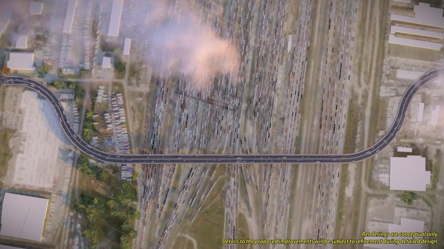
29 Preliminary Preferred Plan View of CN MacMillan Yard Crossing Conceptual Aerial View Of Proposed Crossing Conceptual View Of Proposed Bridge Conceptual View Of Proposed Bridge Conceptual Aerial View Of Proposed Crossing 28


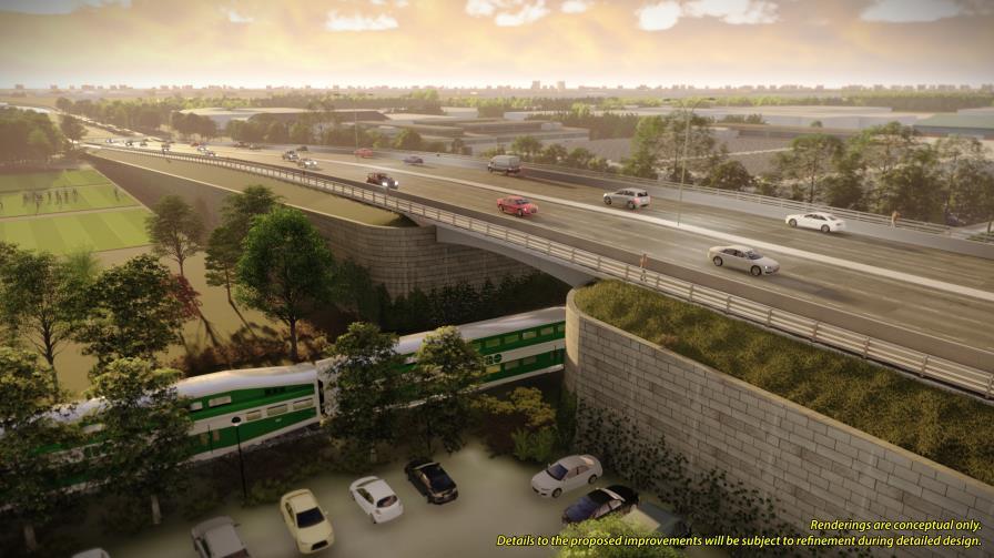
30 Preliminary Preferred Plan View of GO Transit Barrie Line Overpass Conceptual View Of Proposed Bridge Conceptual Aerial View Of Proposed Bridge Conceptual View Of Proposed Bridge Conceptual View Of Proposed Bridge 29


31 Preliminary Preferred Plan Supporting Technical Studies Drainage and Stormwater Management Langstaff Road currently has a mix of ditch drainage and catch basins / storm sewers. In future, all road runoff will be directed to the storm sewer system. A drainage assessment and stormwater management design is being developed for Langstaff Road that includes: Heritage Consultation with Toronto and Region Conservation Authority regarding design criteria, water quality and quantity control objectives; Confirming that the size of culverts and bridges meet design requirements and making recommendations regarding replacement, as appropriate; and Recommending water quality treatment measures. A Stage 1 Archaeological Assessment consisting of background research and visual assessment was conducted to evaluate archaeological potential within the study area. Further assessment may be recommended in areas of the proposed right-of-way that have not been previously disturbed. A cultural heritage review was conducted involving background research of heritage properties and landscapes within the study area. The study did not identify features of heritage value or interest in the proposed right-of-way. Old St. Stephen s Cemetery will not be impacted. Natural Environment The key natural feature in the study area is the West Don River valley. The natural environmental assessment included a review of background information and field investigations: Vegetation community classification and botanical survey; Review of fish habitat conditions at West Don River and other area watercourses; and Review of wildlife habitat type and quality, including potential for Species at Risk. Ministry of Natural Resources and Forestry and Toronto and Region Conservation Authority are being consulted with respect to natural environmental conditions. Permit requirements will be confirmed and recommendations made to protect wildlife, habitat and Species at Risk. 30


32 Preliminary Preferred Plan Typical Langstaff Road Street View Conceptual view of roadway and landscaping Conceptual view of proposed cycle track, boulevard and sidewalk 31
33 Next Steps and How to Stay In Touch Following this Open House the Project Team will: Review all public and agency comments received and respond where appropriate 1 Complete a comment sheet and return it to the Project Team by December 14, Continue to coordinate with technical agencies 2 the Project Team: roads.ea@york.ca Further consultation as required Incorporate refinements into the design, based on public and agency feedback Finalize the Preliminary Design Prepare the Environmental Study Report (ESR) which documents the decision making process of the EA Study File the ESR for a 30-day public review period 3 4 Contact the Project Team: Communications and Community Engagement Specialist ext Review online materials and check in for updates at: york.ca/langstaffstudy 32
WELCOME TO OPEN HOUSE # 3
 Bayview Avenue Class Environmental Assessment Study Steeles Avenue to Elgin Mills Road WELCOME TO OPEN HOUSE # 3 Please sign in and join our mailing list Why Are We Here Tonight? Study Process and Purpose
St. Clair Avenue West Area Transportation Master Plan
 1 (Between Keele Street and Old Weston Road) Public Information Centre 1 December 2, 2015 2 Welcome Welcome to the first Public Information Centre for the St. Clair Avenue West Area. The panels will present
Adelaide Street / Canadian Pacific Railway (CPR) Grade Separation Class Environmental Assessment. Public Information Centre 3
 Grade Separation Class Environmental Assessment. Public Information Centre 3") 1 Adelaide Street / Canadian Pacific Railway (CPR) Grade Separation Study Process and Purpose of PIC 3 2 Study Commencement February 2016 Phase 1: Problem and Opportunity Identify problems and opportunities
1 Adelaide Street / Canadian Pacific Railway (CPR) Grade Separation Study Process and Purpose of PIC 3 2 Study Commencement February 2016 Phase 1: Problem and Opportunity Identify problems and opportunities
Portage Parkway Environmental Assessment Public Information Centre No. 1
 City of Vaughan Portage Parkway Environmental Assessment Public Information Centre No. 1 November 25, 2015 Welcome to the Public Information Centre This first Public Information Centre (PIC) introduces
CITY OF VAUGHAN EXTRACT FROM COUNCIL MEETING MINUTES OF JUNE 7, 2016
 Item 5, Report No. 26, of the Committee of the Whole (Working Session), which was adopted without amendment by the Council of the City of Vaughan on June 7, 2016. 5 MUNICIPAL CLASS ENVIRONMENTAL ASSESSMENT
Mavis Road Class Environmental Assessment
 Mavis Road Class Environmental Assessment Public Information Centre #2 Wednesday November 9, 2016 6:00 to 8:00 p.m. Please sign in and complete a comment sheet Review the displays on your own or join in
The West Vaughan Employment Area Secondary Plan Policies
 Part 2: The West Vaughan Employment Area Secondary Plan Policies 2.1 General Policies It is the policy of Council: 2.1.1. That the West Vaughan Employment Area (the WVEA), identified on Schedule 1, will
Adelaide Street / Canadian Pacific Railway (CPR) Grade Separation. Public Information Centre #1
 Grade Separation. Public Information Centre #1") 1 Adelaide Street / Canadian Pacific Railway (CPR) Why Are We Here? 2 The purpose of Public Information Centre (PIC) #1 is to: Introduce the study Provide the study background and context Identify the
1 Adelaide Street / Canadian Pacific Railway (CPR) Why Are We Here? 2 The purpose of Public Information Centre (PIC) #1 is to: Introduce the study Provide the study background and context Identify the
Purpose of Open House #3
 Public Meeting #3 May 9, 2009 MVVA Team Purpose of Open House #3 The main purpose of this Open House is to present and seek input on the: Evaluation of transportation and infrastructure design alternatives
Public Meeting #3 May 9, 2009 MVVA Team
 Public Meeting #3 May 9, 2009 MVVA Team Welcome to the third Public Meeting for the Lower Don Lands Municipal Class Environmental Assessment (EA) Infrastructure Master Plan and Keating Channel Precinct
Commissioners Road West Realignment Environmental Assessment
 City of London Commissioners Road West Realignment Environmental Assessment Public Information Centre No. 1 March 30, 2017 Welcome to the Public Information Centre This first Public Information Centre
Second Line West Pedestrian/Cyclist Crossing of Highway 401 Class EA. Second Line West Pedestrian/Cyclist Crossing of Highway 401 Class EA
 1 1 Purpose of Public Information Centre #2 To provide interested and/or potentially affected stakeholders with an opportunity to participate in the planning and decision-making process for this Municipal
Bostwick Road. Municipal Class Environmental Assessment. October 13, City of London. Bostwick Road Municipal Class Environmental Assessment
 Bostwick Road Municipal Class Environmental Assessment October 13, 2016 Welcome! Welcome to the first Public Information Centre for the Bostwick Road Municipal Class Environmental Assessment. Representatives
Commissioners Road West Realignment Environmental Assessment
 City of London Commissioners Road West Realignment Environmental Assessment Public Information Centre No. 2 November 29, 2017 Welcome to the Public Information Centre This 2 nd Public Information Centre
Vaughan Metropolitan Centre (VMC) Black Creek Renewal CLASS ENVIRONMENTAL ASSESSMENT
 Black Creek Renewal CLASS ENVIRONMENTAL ASSESSMENT") PUBLIC INFORMATION CENTRE Vaughan Metropolitan Centre (VMC) Black Creek Renewal Wednesday, May 10, 2017 6:00 p.m. to 8:00 p.m. Add photo Project Management, Environmental Assessment, Stormwater Management
PUBLIC INFORMATION CENTRE Vaughan Metropolitan Centre (VMC) Black Creek Renewal Wednesday, May 10, 2017 6:00 p.m. to 8:00 p.m. Add photo Project Management, Environmental Assessment, Stormwater Management
9 CITY OF VAUGHAN OFFICIAL PLAN AMENDMENT NO BOCA EAST INVESTMENTS LIMITED
 9 CITY OF VAUGHAN OFFICIAL PLAN AMENDMENT NO. 631 - BOCA EAST INVESTMENTS LIMITED The Planning and Economic Development Committee recommends the adoption of the recommendations contained in the following
Emery Village Road 2A Municipal Class Environmental Assessment Study
 PW12.11 STAFF REPORT ACTION REQUIRED Emery Village Road 2A Municipal Class Environmental Assessment Study Date: March 30, 2016 To: From: Wards: Reference Number: Public Works and Infrastructure Committee
Highway 427 Industrial Secondary Plan Area 47 Schedule C Class Environmental Assessment For Arterial Roadways
 Welcome to Pubic Information Centre #1 Highway 427 Industrial Secondary Plan Area 47 Schedule C Class Environmental Assessment For Arterial Roadways Welcome to Open House # 1 Tonight, we invite you to.
City of Toronto. Emery Village Transportation Master Plan
 City of Toronto Emery Village Transportation Master Plan May 2009 Emery Village Transportation Master Plan Toronto, ON May 2009 Consulting Inc. 100 York Blvd., Suite 300 Richmond Hill, ON L4B 1J8 Tel:
Bostwick Road. Municipal Class Environmental Assessment. Public Information Centre #2 June 14, City of London
 Bostwick Road Municipal Class Environmental Assessment Public Information Centre #2 June 14, 2017 Welcome! Welcome to the 2 nd Public Information Centre for the. Representatives from the and the consulting
CHAIR AND MEMBERS CIVIC WORKS COMMITTEE MEETING ON AUGUST 13, 2018
 TO: FROM: SUBJECT: CHAIR AND MEMBERS CIVIC WORKS COMMITTEE MEETING ON AUGUST 13, 2018 KELLY SCHERR, P.ENG., MBA, FEC MANAGING DIRECTOR, ENVIRONMENTAL & ENGINEERING SERVICES AND CITY ENGINEER ADELAIDE STREET
COUNCIL ATTACHMENT 2 HIGHWAY 7 CORRIDOR AND VAUGHAN NORTH-SOUTH LINK
 COUNCIL ATTACHMENT 2 HIGHWAY 7 CORRIDOR AND VAUGHAN NORTH-SOUTH LINK Welcome! The purpose today is to: Present the Study Background; Describe Alignment Alternatives Analyzed; Present the Evaluation of
Introduction. Public Information Package. Project website. Overview. Class Environmental Assessment Process
 1 Introduction Public Information Package Baseline Road Extension between Lambs Road and Bennett Road, Bowmanville Schedule B Municipal Class Environmental Assessment November 6, 2017 Overview The purpose
GLEN ROAD PEDESTRIAN BRIDGE ENVIRONMENTAL ASSESSMENT STUDY PUBLIC INFORMATION CENTRE #2 OCTOBER 24, 2017
 GLEN ROAD PEDESTRIAN BRIDGE ENVIRONMENTAL ASSESSMENT STUDY PUBLIC INFORMATION CENTRE #2 OCTOBER 24, 2017 Glen Road Pedestrian Bridge Class Environmental Assessment 1 WELCOME! Welcome to the second Public
The purpose of tonight s PIC is to:
 The purpose of tonight s PIC is to: Provide an overview of the work completed to date and a summary of the Class EA process being followed; Provide a summary of public input received so far, including
Gold Line Bus Rapid Transit Transit Oriented Development (BRTOD) Helmo Station Area Plan
 Helmo Station Area Plan") Appendix F Gold Line Bus Rapid Transit Transit Oriented Development (BRTOD) Helmo Station Area Plan Introduction and Purpose of the Plan The Gold Line Bus Rapid Transit facility is an eleven-mile dedicated
Appendix F Gold Line Bus Rapid Transit Transit Oriented Development (BRTOD) Helmo Station Area Plan Introduction and Purpose of the Plan The Gold Line Bus Rapid Transit facility is an eleven-mile dedicated
12 AMENDMENT NO. 149, TOWN OF MARKHAM HIGHWAY 404 NORTH SECONDARY PLAN
 12 AMENDMENT NO. 149, TOWN OF MARKHAM HIGHWAY 404 NORTH SECONDARY PLAN The Planning and Economic Development Committee recommends the adoption of the recommendation contained in the following report August
Don Mills Crossing Study and Celestica Lands Development Application Community Meeting, Open House, and Breakout Discussions
 Consultation Summary Don Mills Crossing Study and Celestica Lands Development Application Community Meeting, Open House, and Breakout Discussions This report is not intended to provide a verbatim transcript
FANSHAWE PARK ROAD/RICHMOND STREET INTERSECTION IMPROVEMENTS. PUBLIC INFORMATION CENTRE 2 June 16, 2016
 FANSHAWE PARK ROAD/RICHMOND STREET INTERSECTION IMPROVEMENTS Municipal Class Environmental Assessment PUBLIC INFORMATION CENTRE 2 June 16, 2016 ACCESSIBILITY Under the Accessibility Standards 2015 for
Shift Rapid Transit Public Participation Meeting May 3, 2017
 Shift Rapid Transit Public Participation Meeting May 3, 2017 Shift Rapid Transit Initiative Largest infrastructure project in the city s history. Rapid Transit initiative will transform London s public
Municipal Class EA Study Public Information Centre No. 1 December 13, :00 pm 7:00 pm. Please sign in so we can keep you updated on this study
 Reconstruction of Regional Road 45 (Creek Road) Between Regional Road 27 (River Road) and Regional Road 63 (Canborough Road) in the Township of Wainfleet Municipal Class EA Study Public Information Centre
McKay Road Interchange and Salem / Lockhart Crossing
 McKay Road Interchange and Salem / Lockhart Crossing The McKay Road Interchange Class EA has two components: 1. A new MacKay Road Interchange at Highway 400; and 2. A new bridge crossing of Highway 400
City of London Adelaide Street North - Canadian Pacific Railway Grade Separation Class Environmental Assessment Study Report
 Executive Summary ES1 Introduction The City of London has completed a Class Environmental Assessment (Class EA) study for the Adelaide Street North - Canadian Pacific Railway Grade Separation. While the
ONLINE PUBLIC INFORMATION CENTRE
 ONLINE PUBLIC INFORMATION CENTRE County Road 17 Bridge Replacements Detail Design and Environmental Assessment GWP 4203-15-00 The Ministry of Transportation Ontario (MTO) has retained CH2M Hill and Dillon
Public Information Centre #1
 and Highway 401 Interchange Improvements WELCOME Public Information Centre #1 Veterans Memorial Parkway Extension and Highway 401 Interchange Improvements Study May 23, 2012 4 p.m. to 7 p.m. Brief Overview
WELCOME and introduction
 1 WELCOME and introduction Mobility Hub Locations within Burlington STUDY OVERVIEW STUDY OBJECTIVES The City of Burlington is developing four Area Specific Plans, one for each of Burlington s Mobility
THE GARDEN CITY PLAN. City of St. Catharines Official Plan. City of St. Catharines
 THE GARDEN CITY PLAN City of St. Catharines Official Plan City of St. Catharines August 2010 APPROVAL INFORMATION This Official Plan of the City of St. Catharines Planning Area, known as the Garden City
Northeast Anthony Henday Drive Manning Freeway to Whitemud Drive Welcome to this Construction Information Session
 Manning Freeway to Whitemud Drive Welcome to this Construction Information Session Purpose To inform interested residents and businesses about the plans accommodation. Background: The Government of Alberta
PROJECT BACKGROUND. Preliminary Design Scope and Tasks
 PROJECT BACKGROUND Preliminary Design Scope and Tasks The purpose of this Study is the development of preliminary designs for intersection improvements for Trunk Highway (TH) 36 at the intersections of
NORTHEAST RIVER CROSSING FUNCTIONAL PLANNING STUDY
 WELCOME Northeast River Crossing Functional Planning Study Phase 2 Public Meeting 4 to 8 PM Informal drop-in format and discussion tables Meeting Purpose Introduce the Northeast River Crossing Functional
11.4 Highway 400 North Employment Lands Secondary Plan APPROVED BY THE ONTARIO MUNICIPAL BOARD ON NOVEMBER 21, 2011
 11.4 Highway 400 North Employment Lands Secondary Plan APPROVED BY THE ONTARIO MUNICIPAL BOARD ON NOVEMBER 21, 2011 11.4.1 General 11.4.1.1. as approved by the Ontario Municipal Board on November 21, 2011,
Transportation. Strategies for Action
 Transportation A major priority for the Overlake Neighborhood is to develop a multimodal transportation system. To achieve this system, a balance has to be found among travel, circulation and access needs;
Stage 2 ION: Light Rail Transit (LRT) from Kitchener to Cambridge
 from Kitchener to Cambridge") Stage 2 ION: Light Rail Transit (LRT) from Kitchener to Cambridge Public Consultation Centre No. 3 Cambridge City Hall, November 21, 2 8 p.m. Preston Memorial Auditorium, November 28, 4 8 p.m. Public Information
Stage 2 ION: Light Rail Transit (LRT) from Kitchener to Cambridge Public Consultation Centre No. 3 Cambridge City Hall, November 21, 2 8 p.m. Preston Memorial Auditorium, November 28, 4 8 p.m. Public Information
NORTH-SOUTH CORRIDOR STUDY EXECUTIVE SUMMARY. Executive Summary
 Executive Summary Background As congestion continues to affect mobility in the region, the Ozarks Transportation Organization (OTO) is particularly concerned with traffic movement. The North-South Corridor
Bridge Type Assessment and Evaluation
 16M-01410-01 (3216026) Glen Road Pedestrian Bridge EA Study Bridge Type Assessment and Evaluation Factor Group/Criteria Alternative 1: Steel girder with two inclined steel legs Alternative 2: Steel girder
Building the transportation network we need for the future
 Building the transportation network we need for the future WHO IS METROLINX? Metrolinx was created in 2006 by the Province of Ontario with a mandate to create greater connection between the communities
Better Cycling. The City will update the cycling master plan (London ON Bikes) based on the approved BRT network.
 based on the approved BRT network.") Better Cycling Dedicated bike facilities will be constructed along BRT corridors where space is available. Nearby bike routes will also be upgraded to ensure a complete network is available for cyclists.
Better Cycling Dedicated bike facilities will be constructed along BRT corridors where space is available. Nearby bike routes will also be upgraded to ensure a complete network is available for cyclists.
Issues Requiring Future Study
 Issues Requiring Future Study Transportation planning is an ongoing process that tends to identify new issues as it finds solutions for others. Some issues are so complex that a solution to one problem
TOWN OF WHITBY REPORT RECOMMENDATION REPORT
 TOWN OF WHITBY REPORT RECOMMENDATION REPORT REPORT TO: Council REPORT NO: PL 95-09 DATE OF MEETING: October 13, 2009 PREPARED BY: Planning/Public Works Joint Report FILE NO(S): N/A LOCATION: N/A REPORT
SPECIAL COMMITTEE OF THE WHOLE DECEMBER 9, 2002 BLOCK 57/58 WEST BLOCK PLAN BLOCK PLAN FILE BL.57/58W.99 HUNTINGTON BUSINESS PARK LAND OWNERS
 SPECIAL COMMITTEE OF THE WHOLE DECEMBER 9, 2002 BLOCK 57/58 WEST BLOCK PLAN BLOCK PLAN FILE BL.57/58W.99 HUNTINGTON BUSINESS PARK LAND OWNERS Recommendation The Commissioner of Planning recommends: THAT
TRANSPORTATION COMMITTEE
 TRANSPORTATION COMMITTEE CITY OF OTTAWA Ministry of Transportation Detailed Design Assignment G.W.P.# 4058-01-00 Highway 417 (Ottawa Queensway) Widening & Rehabilitation from Maitland Avenue to Island
Burloak Drive Grade Separation
 Burloak Drive Grade Separation Transit Project Assessment Process Public Meeting #1 March 30, 2017 GO Lakeshore West Service Plan Weekday Rush Hour 15-minute, two-way service between Aldershot* and Union
Heritage Road Improvements from Steeles Avenue to Rivermont Road
 The Corporation of the City of Brampton Heritage Road Improvements from Steeles Avenue to Rivermont Road Class Environmental Assessment Study (Schedule C) September 19, 2013 The Corporation of the City
GEOMETRIC IMPROVEMENTS AND WATERMAIN LOOPING MUNICIPAL CLASS ENVIRONMENTAL ASSESSMENT
 GEOMETRIC IMPROVEMENTS AND WATERMAIN LOOPING MUNICIPAL CLASS ENVIRONMENTAL ASSESSMENT Veterans Way (previously Powerline Road) and Klondike Park Road Wasaga Beach Welcome Please sign in Take a comment
PD&E STUDY SR 9/I-95 FROM SOUTH OF SR 870/COMMERCIAL BOULEVARD TO NORTH OF CYPRESS CREEK ROAD FM # ETDM 14222
 PD&E STUDY SR 870/COMMERCIAL BOULEVARD TO NORTH OF CYPRESS CREEK ROAD FM # 435808-1-22-02 ETDM 14222 WELCOME TO THE KICK-OFF MEETING May 24, 2016 1 1 2 3 4 5 6 PLANNING PROJECT DEVELOPMENT AND ENVIRONMENT
The Commissioner of Engineering and Public Works recommends that this report be received for information purposes.
 COMMITTEE OF THE WHOLE FEBRUARY 1, 2011 407 TRANSITWAY - ENVIRONMENTAL PROJECT REPORT MINISTRY OF TRANSPORTATION CITY WIDE Recommendation The Commissioner of Engineering and Public Works recommends that
CITY OF VAUGHAN KIRBY GO TRANSIT HUB SUB-STUDY
 WELCOME! Thank you for attending, and welcome to the first of three Public Meetings for the Kirby GO Transit Hub Study. Your feedback is important to us, and will help inform the development of the draft
3 MARKHAM NORTH-SOUTH LINK CORRIDOR PUBLIC TRANSIT IMPROVEMENTS ENVIRONMENTAL ASSESSMENT UPDATE
 3 MARKHAM NORTH-SOUTH LINK CORRIDOR PUBLIC TRANSIT IMPROVEMENTS ENVIRONMENTAL ASSESSMENT UPDATE The Rapid Transit Public/Private Partnership Steering Committee recommends the adoption of the recommendations
Recreational Pathway Crossing of Richmond Street Municipal Class Environmental Assessment. Public Information Centre #2 April 22, 2015
 Recreational Pathway Crossing of Richmond Street Municipal Class Environmental Assessment Public Information Centre #2 April 22, 2015 1. Study Process PHASE 1 PHASE 2 PHASE 3 PHASE 1 : Problem/Opportunity
Relief Line Project Assessment
 Relief Line Project Assessment Public Information Centre April 5, 2017 Tonight s Meeting PURPOSE To review the preferred alignment for the Local Segment. AGENDA 6:30 Open House 7:00 Presentation / Discussion
Strachan Ave. Overpass Community Design Update. October 26, 2010 Stephen Lipkus Executive Director Georgetown South Project GO Transit
 Strachan Ave. Overpass Community Design Update October 26, 2010 Stephen Lipkus Executive Director Georgetown South Project GO Transit Welcome Program Overview 6:30 8:30 p.m.: Storyboard Review Project
PREPARED FOR: PLATTEVIEW ROAD CORRIDOR STUDY EXECUTIVE SUMMARY
 PREPARED FOR: PLATTEVIEW ROAD CORRIDOR STUDY EXECUTIVE SUMMARY SEPTEMBER 2016 Introduction The Platteview Road Corridor Study was led by the Metropolitan Area Planning Agency (MAPA) with assistance from
1.0 INTRODUCTION AND BACKGROUND
 1.0 INTRODUCTION AND BACKGROUND 1.1 INTRODUCTION / BACKGROUND The Regional Municipality of York (hereafter referred to as York Region ) has completed a Municipal Class Environmental Assessment (Class EA)
The Illinois Department of Transportation and Lake County Division of Transportation. Route 173, including the Millburn Bypass
 The Illinois Department of Transportation and Lake County Division of Transportation welcome you to this Public Hearing for U.S. Route 45 from Illinois Route 132 to Illinois Route 173, including the Millburn
2 STATUTORY PUBLIC MEETING AND INFORMATION REPORT FOR PUBLIC MEETING ON AMENDMENT NO. 62 TO THE YORK REGION OFFICIAL PLAN
 2 STATUTORY PUBLIC MEETING AND INFORMATION REPORT FOR PUBLIC MEETING ON AMENDMENT NO. 62 TO THE YORK REGION OFFICIAL PLAN Pursuant to Section 17(15) of the Planning Act, as amended, the Regional Planning
North York Centre South Service Road
 North York Centre South Service Road Municipal Class Environmental Assessment Addendum Potential Changes to Doris Avenue, Bonnington Place & Tradewind Avenue Study Summary (June 11, 2015) toronto.ca/nyc-south-road.
112th Avenue Light Rail Options Concept Design Report JUNE 2010 PREPARED FOR PREPARED BY TBG PGH
 112th Avenue Light Rail Options Concept Design Report JUNE 2010 PREPARED FOR PREPARED BY TBG060310124909PGH C ontents Introduction 1 Project Overview 1 Public Involvement and Technical Coordination 4 Description
Lower Don River West Remedial Flood Protection Project TABLE OF CONTENTS. Page. Executive Summary
 TABLE OF CONTENTS Page Executive Summary 1.0 INTRODUCTION...1-1 1.1 Purpose of the Undertaking...1-1 1.2 Study Area Description...1-1 1.3 Description of the Undertaking...1-1 1.4 Rationale for the Undertaking...1-2
1.1.1 Growth Plan for the Greater Golden Horseshoe 2006 Office Consolidation January 2012
 HDR Corporation 100 York Blvd. Suite 300 Richmond Hill, ON L4B 1J8 Tel: (905) 882-4100 Fax: (905) 882-1557 www.hdrinc.com File: 2.0 Memorandum To: Amber Parnell Town of Innisfil Cc: From: Carl Wong - HDR
MAYFIELD WEST SECONDARY PLAN PHASE 2
 MAYFIELD WEST SECONDARY PLAN PHASE 2 Public Open House #3 February 25, 2010 Draft Preferred Land Use Scenario TOWN OF CALEDON PLANNING & DEVELOPMENT DEPARTMENT Open House Agenda TOWN OF CALEDON 1. Welcome
Mississippi Skyway Preliminary Engineering Report
 EXECUTIVE SUMMARY Mississippi Skyway Preliminary Engineering Report CITY OF RAMSEY, MINNESOTA DECEMBER 2014 City of RAMSEY EXECUTIVE SUMMARY Project Need and Intent The Mississippi Skyway pedestrian bridge
Scope of Services. River Oaks Boulevard (SH 183) Corridor Master Plan
 Corridor Master Plan") Scope of Services River Oaks Boulevard (SH 183) Corridor Master Plan PROJECT AREA The project area consists of the River Oaks Boulevard (SH 183) corridor bounded by SH 199 at the northern end and the Trinity
Scope of Services River Oaks Boulevard (SH 183) Corridor Master Plan PROJECT AREA The project area consists of the River Oaks Boulevard (SH 183) corridor bounded by SH 199 at the northern end and the Trinity
Public Information Centre. Welcome
 Transportation Improvements from the Beaver Creek Bridge to the Entrance of Santa s Village District of Muskoka Municipal Class Environmental Assessment Welcome Please sign in Take a comment sheet Staff
CONSULTING SERVICES FOR THE WHITEBELT VISIONING EXERCISE ADDENDUM TO THE GTA WEST LAND USE STUDY WORK PROGRAM
 CONSULTING SERVICES FOR THE WHITEBELT VISIONING EXERCISE ADDENDUM TO THE GTA WEST LAND USE STUDY 1. Introduction WORK PROGRAM The Town of Caledon is a large, local municipality located in the Greater Toronto
CONTENTS 2.0 A FRAMEWORK FOR SUSTAINABLE GROWTH 2.1 MANAGING SUSTAINABLE GROWTH THE VISION TO GOALS AND OBJECTIVES 2.3 MARKHAM STRUCTURE
 2 A Framework for Sustainable Growth 2.0 A FRAMEWORK FOR SUSTAINABLE GROWTH CONTENTS 2.1 MANAGING SUSTAINABLE GROWTH THE VISION TO 2031 2.2 GOALS AND OBJECTIVES 2.2.1 Protecting the Natural Environment
Committee of the Whole (Public Hearing) Report
 Report") Item:1 Committee of the Whole (Public Hearing) Report DATE: Tuesday, June 05, 2018 WARD: 2 TITLE: OFFICIAL PLAN AMENDMENT FILE OP.17.016 ZONING BY-LAW AMENDMENT FILE Z.17.046 IMPORTANNE MARKETING INC.
Item:1 Committee of the Whole (Public Hearing) Report DATE: Tuesday, June 05, 2018 WARD: 2 TITLE: OFFICIAL PLAN AMENDMENT FILE OP.17.016 ZONING BY-LAW AMENDMENT FILE Z.17.046 IMPORTANNE MARKETING INC.
SDOT DPD. SDOT Director s Rule DPD Director s Rule DCLU DR SED DR of 7 CITY OF SEATTLE
 SDOT SDOT Director s Rule 2-07 DPD Applicant: CITY OF SEATTLE Page 1 of 7 Supersedes: DCLU DR 11-93 SED DR 93-4 Seattle Department of Transportation (SDOT) Department of Planning and Development (DPD)
7 HIGHWAY 7 CORRIDOR AND VAUGHAN N-S LINK ENVIRONMENTAL ASSESSMENT RECOMMENDED ALIGNMENT
 7 HIGHWAY 7 CORRIDOR AND VAUGHAN N-S LINK ENVIRONMENTAL ASSESSMENT RECOMMENDED ALIGNMENT The Rapid Transit Public/Private Partnership Steering Committee recommends the adoption of the recommendations contained
Elfrida Growth Area Study
 Elfrida Growth Area Study Public Information Centre #2 December 6, 2017 6:00-8:30 pm PLANNING & ECONOMIC DEVELOPMENT DEPARTMENT Purpose of the Study The Elfrida Area has been identified as the preferred
Coordinated Transit Planning in Toronto SmartTrack GO RER Scarborough Relief Line Waterfront Transit
 Coordinated Transit Planning in Toronto SmartTrack GO RER Scarborough Relief Line Waterfront Transit Public Information Centres February 2016 Transportation Planning Section City Planning Division Toronto
Master Environmental Servicing Plan & Secondary Plan
 1 East Side Lands Stage 2 Master Environmental Servicing Plan & Secondary Plan Public Consultation Centre #4 March 20, 2018 Welcome! Today s Agenda Please sign in at the registration table. 6:00 pm 6:30
11.9 West Vaughan Employment Area Secondary Plan
 City of Vaughan Official Plan Volume 2 2017 Office Consolidation As Partially Approved by the Ontario Municipal Board 11.9 West Vaughan Employment Area Secondary Plan APPROVED BY THE ONTARIO MUNICIPAL
11.4 Highway 400 North Employment Lands Secondary Plan
 11.4 Highway 400 North Employment Lands Secondary Plan APPROVED BY THE ONTARIO MUNICIPAL BOARD ON NOVEMBER 21, 2011 11.4.1 General 11.4.1.1. The following policies and Schedules A - I form Official Plan
Workshop 3. City of Burlington Waterfront Hotel Planning Study. September 14, The Planning Partnership
 Workshop 3 City of Burlington Waterfront Hotel Planning Study September 14, 2017 The Planning Partnership The Waterfront Hotel Planning Study 01 The Brant & Lakeshore Planning Study will establish a Strategic
2.0 A FRAMEWORK FOR SUSTAINABLE GROWTH CONTENTS
 2-2 A Framework for Sustainable Growth 2.0 A FRAMEWORK FOR SUSTAINABLE GROWTH CONTENTS 2.1 MANAGING SUSTAINABLE GROWTH THE VISION TO 2031 2.2 GOALS AND OBJECTIVES 2.2.1 Protecting the Natural Environment
REVIEW AND EVALUATION OF REGIONAL LAND USE
 REVIEW AND EVALUATION OF REGIONAL LAND USE AND TRANSPORTATION SCENARIOS #220831 Environmental Justice Task Force October 7, 2014 VISION 2050 Process Development of Guiding Vision for Land Use and Transportation
South Yonge Street Corridor
 South Yonge Street Corridor Streetscape Master Plan Study Draft Final Executive Summary Prepared by: January 2012 In Partnership with: Introduction The Future... Yonge Street is at the forefront of York
Municipal Heritage Bridges Cultural, Heritage and Archaeological Resources Assessment Checklist Revised April 11, 2014
 Municipal Heritage Bridges Cultural, Heritage and Archaeological Assessment Checklist Revised April 11, 2014 This checklist was prepared in March 2013 by the Municipal Engineers Association to assist with
The Gore Road Queen Street East to Castlemore Road
 Municipal Class Environmental Assessment The Gore Road Queen Street East to Castlemore Road Public Open House # 1 Date: Thursday May 29, 2014 Time: 5:30pm to 8:30pm Location: Gore Meadows Community Centre
Welcome. Walk Around. Talk to Us. Write Down Your Comments
 Welcome This is an information meeting introducing the applications for proposed redevelopment of the Yorkdale Shopping Centre site at 3401 Dufferin Street and 1 Yorkdale Road over the next 20+ years,
ELMVALE ACRES SHOPPING CENTRE MASTER PLAN
 ELMVALE ACRES SHOPPING CENTRE MASTER PLAN Contents 1.0 INTRODUCTION... 2 2.0 LOCATION... 2 3.0 EXISTING CONTEXT... 2 4.0 VISION & GUIDING PRINCIPLES... 2 5.0 LAND USE AND BUILT FORM... 4 5.1 St. Laurent
Implementation Guide Comprehensive Plan City of Allen
 Implementation Guide 2030 Comprehensive Plan City of Allen DRAFT 2015 Implementation Guide Allen 2030 Comprehensive Plan INTRODUCTION The Comprehensive Plan serves as a guide for the growth and development
Master Plan Class Environmental Assessment for Downtown Mississauga Road Improvements
 Master Plan Class Environmental Assessment for Downtown Mississauga Road Improvements Public Information Centre # 1 Wednesday June 25, 2014 5:30 p.m. to 8:00 p.m. Mississauga Civic Centre Great Hall Welcome
Toronto Complete Streets Guidelines
 c. DTAH 58 60 3.1 70 3.2 Performance Measurement 71 3.3 Exceptions Chapter 3 describes the five general steps in the street design process. Not all projects follow these steps, as the number of steps and
Executive Summary. NY 7 / NY 2 Corridor
 Executive Summary NY 7 / NY 2 Corridor Transportation and Land Use Study December 2005 Prepared for: Town of Colonie Capital District Transportation Committee Prepared by: Introduction: Land use decisions
CITY OF VAUGHAN EXTRACT FROM COUNCIL MEETING MINUTES OF NOVEMBER 15, 2016
 Item 11, Report No. 38, of the Committee of the Whole, which was adopted without amendment by the Council of the City of Vaughan on November 15, 2016. Regional Councillor Di Biase declared an interest
Alta Vista Transportation Corridor Environmental Study Report November 2005
 Alta Vista Transportation Corridor Environmental Study Report November 2005 6.0 ALTERNATIVE DESIGNS The Preferred Solution to providing additional transportation system capacity through the AVTC study
Services Department B September 10, 2007
 Report To: Development Services Committee Item: Date of Report: DS-07-246 September 5, 2007 From: Commissioner, Development File: Date of Meeting: Services Department B7200-0001 September 10, 2007 Subject:
Relief Line Project Assessment
 Relief Line Project Assessment Stakeholder Advisory Meeting #4 May 30, 2016 Tonight s Meeting PURPOSE To present and discuss: Results of the evaluation of potential alignments Emerging preferred alignment
Complete Neighbourhood Guidelines Review Tool
 Complete Neighbourhood Guidelines Review Tool Prepared By: City of Regina Planning Department October 2014 Page 1 of 14 Community Development Review Checklist for Secondary Plans and Concept Plans The