MUNICIPALITY OF ANCHORAGE
|
|
|
- Aubrey Hampton
- 5 years ago
- Views:
Transcription


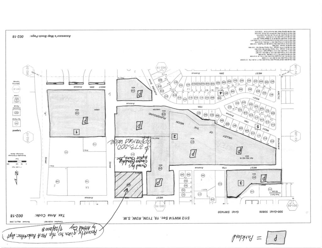
1 MUNICIPALITY OF ANCHORAGE ANCHORAGE PARKS & RECREATION PRC # a DATE: November 2, 2009 TO: FROM: Park and Recreation Commission Suzanne R. Little, Senior Park Planner SUBJECT: Valley of the Moon Park Improvements At the August PRC meeting, Commissioners received an introductory presentation about the plans for a park construction project at Valley of the Moon Park. This month, the Parks and Recreation Commission presentation is for the purpose of consideration and approval of the project design in preparation for submittal to Urban Design Commission on December 9 th. The projected schedule will put the project out to bid in January 2010 for construction during the 2010 summer season. Attached: Overall Park Upgrade Plan Project Budget Park Ownership Map Draft Parks and Recreation Commission Resolution Design Study Report Ralph Rentz, Landscape Architect, Project Management and Engineering Valley of the Moon - Process Overview The 10-person Valley of the Moon Park Citizen s Advisory Group met on 10 occasions to discuss improvements desired for the park. The Citizen s Advisory Group reserved the picnic shelter at Valley of the Moon (VOM) Park for a public gathering on June 24, held for the purpose of gaining additional input from the neighborhood and users of the park regarding prioritization of park improvements. Approximately 60 people participated in the dot-mocracy prioritization exercise regarding park improvements at Valley of the Moon Park. Below is a list members of the Valley of the Moon Park Citizen s Advisory Group. Kathleen Weeks (SACC President) Ashley Kalli (SACC) Lanie Fleischer (SACC) Matt Johnson (NSCC President) Susan Miller (NSCC) Sharon Schlicht (NSCC) Tracy Fischbach (NSCC) Xavier Schlee (NSCC) Robert Shipley (Anch Waterways) Chone (Laotian Community) Mark Butler (FCC/NSCC) Valley of the Moon Park Improvements 1 of 2 11/3/2009
2 Park Overview Valley of the Moon Park is a acre community-use park located within the Chester Creek Greenbelt bordering both the South Addition and North Star neighborhoods. The park is bordered by Chester Creek along the southern border on the western two thirds of the park while the northern border continues along 16 th & 17 th Avenues. The developed areas of the park are used for a variety of community events with upwards of 100,000 users each summer. Roughly half the park is undeveloped and heavily wooded with a birch, poplar, and spruce forest. There is a 5-acre in-holding in the park owned by the Greater Friendship Baptist Church and there is a community desire to investigate the possibility of a trade to eliminate this in-holding at Valley of the Moon Park. Improvement Overview Through extensive public input concerning desires at the park, the Taskforce prioritized potential improvements at the park that are included in this project. Of critical concern were desired improvements at the playground and an addition of a second picnic shelter for benefit of the current park users. Additionally a scoping study funded under this project is planned to investigate the method and cost of addressing the stream-bank degradation at this location. An adult fitness station is planned along with updated signage for the entrance and way-finding. Additionally new picnic tables and coal disposal bins will be installed as part of this project. Project Budget: The total Budget for the project is $590,694 with approximately $400,000 going directly to construction. The funds are derived from a 2008 Parks Bond and a Legislative appropriation. Valley of the Moon Park Improvements 2 of 2 11/3/2009
3
4
5
6 MUNICIPALITY OF ANCHORAGE ANCHORAGE PARKS & RECREATION RESOLUTION No Valley of the Moon Park Project Design Approval WHEREAS, the Anchorage Parks and Recreation Commission serves in an advisory capacity to both the Mayor and the Assembly; and WHEREAS, the Anchorage Parks and Recreation Commission has the responsibility and duty to provide for the long term vision of our park system by ensuring that a balance of parks, natural resources, and recreation facilities provides for the health, welfare, and safety of all residents of the Anchorage Bowl; and WHEREAS the Valley of the Moon Park area of the South Addition and North Star Community Councils is one of the most loved and widely-used parks in the Municipality s park system, and WHEREAS, the South Addition and North Star Community Councils and their members have lobbied to achieve state legislative appropriation for improvements at Valley of the Moon Park; and WHEREAS, the South Addition and North Star Community Council have participated in extensive public involvement process and are supportive of the proposed improvements at Valley of the Moon Park. NOW THEREFORE BE IT RESOLVED, that the Anchorage Parks and Recreation Commission recommends the Municipality of Anchorage pursue proposed park improvements as described in the staff report dated PASSED AND APPROVED by the Anchorage Parks and Recreation Commission this 12th day of November, Kathleen Plunkett, Chair Parks and Recreation Commission ATTEST: John Rodda, Director Parks & Recreation Department PRC Resolution Valley of the Moon Park Improvements
7 VALLEY OF THE MOON PARK IMPROVEMENTS November 25, 2009 Introduction: Valley of the Moon Park is a acre community-use park located within the Chester Creek Greenbelt bordering both the South Addition and North Star neighborhoods. The park is bordered by Chester Creek running along the southern border on the western two thirds of the park while the northern border zigzags along 16 th & 17 th Avenues. Arctic Boulevard borders the western end of the park and C Street borders the east. Roughly half the park is heavily wooded with a birch, poplar, and spruce forest and remains undeveloped. The developed areas of the park are used for a variety of community events with upwards of 100,000 users each summer. The park has developed through the years with picnic areas, a picnic shelter, both permanent and seasonal restrooms, playground, a ball field, and other various park amenities. There is a small parking lot located along 17 th Avenue and is often full in the summer months when events are scheduled at this very popular park. The park is very popular with both private daycare centers in the area and public school events. During these periods, overflow parking occurs along 17 th Avenue. There are community garden plots and a corresponding parking lot at the far eastern end of the park accessed by C Street. The park has excellent pedestrian access from surrounding neighborhoods including the Chester Creek Greenbelt Trail as well as north/south paved connections from the South Addition and North Star neighborhoods. Extensive public outreach has occurred by the Parks and Recreation Department the past several months to develop this plan with adjacent community councils, various user groups, and state legislators. Construction is scheduled for summer Cost: Plant Material Budget: N/A Total Landscape Budget: N/A Construction Budget: $490, Feasibility: At the request of the Parks and Recreation Department, there will be no plant material added to the park as part of this phase. Typical ongoing landscape maintenance (lawn mowing, weeding, watering, etc.) at Valley of the Moon Park will be conducted by the Parks and Recreation Department, as is done at other park sites throughout Anchorage. Landscape maintenance items that require professional (tree trimming, plant replacement, etc.) will be done specifically by the Municipality s Horticulture section. 3: Planning and Design Criteria, including: a. the external impacts generated by the project on adjacent areas:
8 Valley of the Moon Park Improvements November 25, 2009 / Page 3 Improvements to the park include improved pedestrian access into the most heavily used section of the park from the sidewalk along W. 17 th Avenue. Views into the park will be improved with more organization to the elements constructed within the park including portable restroom screening. The improvements will provide a better park experience for the surrounding neighborhoods with increased facilities and better pedestrian circulation. b. the extent to which the landscaping elements complement, maintain, or improve the landscape quality of adjacent neighborhoods and areas: The project does not include landscaping elements see explanation above. c. The degrees to which the landscape elements contribute to on-site use of the project, including safe, efficient, and comfortable public use: A. EXISTING PLAYGROUND REHABILITATION: The existing playground, located at the western end of the park, consists of four separate play areas; each set at different elevations, and each bordered with concrete headers containing gravel and sand. The feature playground piece, a rocket ship, was last replaced in the late 1990 s when it was custom designed and installed. Other equipment includes a combination climbing /swing structure for tots that no longer meet CPSC guidelines; a jungle gym that underutilizes the existing footprint; and a worn stand alone swing set. Several spring toys have been randomly installed adjacent to the rocket; unwisely mixing age-appropriate equipment for tots with equipment designed for older children in such an active area. There are no signs indicating the intended user age groups. The concrete headers and retaining walls will be retained as part of the playground upgrades thereby retaining the basic design of the area including the accessible pathway from the parking lot. The Rocket will remain in place and with basic repairs, will continue to serve the community for years. The jungle gym, spring toys, and climbing/swing structure will be replaced with equipment meeting current safety standards and segregated by age appropriateness. The nicely detailed, original concrete headers and retaining walls, constructed 20+ years ago, are in good shape with minimal surface cracking still adequately contain the play equipment, and will be retained as part of this playground safety upgrade as a cost saving. The grassy areas between the concrete headers are worn, muddy in
9 Valley of the Moon Park Improvements November 25, 2009 / Page 4 wet weather, and overall make maneuvering between the different play areas difficult. The asphalt and grassy areas in and around the play areas will be replaced with paved surfaces allowing accessible pathways to each play area. Existing benches and trash receptacles will be repositioned and integrated into the new design. Grass and weeds have infiltrated the existing compacted sand in some of the play areas and what remains no longer a function as an adequate safety surface for play equipment. Although pea gravel is considered an adequate safety surface, it is not contained within the concrete headers and is kicked, spilled, and thrown onto the adjacent paving causing safety problems of its own. Pea gravel, safety surfacing, and sand in all four play areas will be replaced with a more appropriate impact-absorbing material. B. PICNIC SHELTER: Due to the popularity of this park, a second picnic shelter will be constructed to accommodate the need. Because the existing shelter tends to focus on the adjacent well-used lawn area and playground, and is popular with groups involving children, the proposed shelter, while visible to the playground, will be focused away from that area and towards an underutilized lawn area that would be redeveloped in a future phase. This picnic shelter would incorporate the same palette of materials as other elements in the park and will have an enlarged paved pad to accommodate spill over from larger groups. An accessible trail will lead to the shelter from the parking lot. C. VOLLEYBALL COURTS: At the request of the community, two sand volleyball courts will be added to the park. The courts will have concrete or timber headers and will each have nets. D. PEDESTRIAN ENTRANCE: While there are numerous pedestrian trails into Valley of the Moon Park from surrounding neighborhoods, many would consider the parking lot off W. 17 th Avenue the most used public and visible entrance to the park, and this entrance is currently designed toward arrival by vehicle. It appears that most of the foot traffic and public congregation near the entrance to the park occurs in the southwestern corner of the parking lot where existing asphalt trails lead you either to the picnic shelter to the south, or the heavily used playground to the west. Visually, a park user is met with two trash receptacles, lines of untidy leaning timber bollards, odiferous portable toilets in summer months, and on a busy day, two rows of parked vehicles. A pedestrian entering the park must traverse a worn dirt footpath through the remaining strip of trees on the west end of the parking or
10 Valley of the Moon Park Improvements November 25, 2009 / Page 5 enter by walking through the parking lot itself. Upgrades to the park entrance will include expanding and directing visual focus to a pedestrian node and the addition of an informational kiosk, both located at the southwest corner of the parking lot. E. ADULT FITNESS EQUIPMENT: The community has requested adult fitness equipment for outdoor adult recreation be constructed as part of the improvements in Valley of the Moon Park. The equipment will be grouped and located in close proximity to the Children s Forest (see item F below). The area and equipment will be constructed to meet accessibility requirements. F. CHILDREN S FOREST: A children s nature garden is proposed for a small section of the wooded area south of the existing ball field (see Attachment A) to promote natural play and environmental learning in an unstructured environment. An accessible unpaved pathway will be constructed with a gateway feature as well as interpretive signage. Tree thinning and tree limbing will open up views into the garden and a fence will be added to separate the garden from the surrounding forest. G. PORTABLE RESTROOM SCREENING: Many portable toilets are brought into various municipal parks each summer with no effective attempt to screen them and often these units are placed in locations where parks users complain of offensive odors. This design for Valley of the Moon Park includes suggestions for clustered placement for these portable toilets convenient yet somewhat removed from congregating points and developed activity areas. The portable toilets will have a 7 high privacy timber-framed fence with corrugated metal panels on both sides. The corrugated metal panels will be dark in color and the timber framing would be similarly finished with a solid body stain. d. the visual attractiveness of the landscaping: Not applicable. e. the landscaping elements enhancement of the architecture of the project, including the integration of internal and exterior architectural themes: Not applicable.
MUNICIPALITY OF ANCHORAGE
 MUNICIPALITY OF ANCHORAGE ANCHORAGE PARKS & RECREATION PRC 09-52 b DATE: November 2, 2009 TO: FROM: SUBJECT: Park and Recreation Commission Suzanne R. Little, Senior Park Planner Jewel Lake Park Improvements
Municipality of Anchorage, Alaska Parks & Recreation Department
 Municipality of Anchorage, Alaska Parks & Recreation Department 632 W. 6 th Avenue, Suite 630 P.O. Box 196650 Anchorage, AK 99519 Tel 907-343-4355 URL www.muni.org/departments/parks MEMORANDUM Date: April
ANCHORAGE PARK REPORT CARD Assessing A Park s Appearance, Function, & Condition
 ANCHORAGE PARK REPORT CARD Assessing A Park s Appearance, Function, & Condition Park Name: Is Your Park an A or an F? Your Name: Contact Information Optional: Date: General Instructions: Phone: Email:
Municipality of Anchorage, Alaska Parks & Recreation Department
 Municipality of Anchorage, Alaska Parks & Recreation Department 632 W. 6 th Avenue, Suite 630 P.O. Box 196650 Anchorage, AK 99519 Tel 907-343-4355 URL www.muni.org/departments/parks MEMORANDUM Date: October
Charles P. Johnson and Associates. Annapolis Landscape Architects
 Charles P. Johnson and Associates Annapolis Landscape Architects AGENDA Introduction Project Limits and Scope Site Analysis Opportunities & Constraints Program Goals Image Boards Design Alternatives Pros
Blue Springs Park. Park Land Established: Developed Acres: 12 acres Undeveloped Acres: 2 acres
 Blue Springs Park Park Location: 2204 SW South Ave. Park Land Established: 1975 Park Size: 14 acres Developed Acres: 12 acres Undeveloped Acres: 2 acres Park Type: Neighborhood Park Amenities: Softball
Design Considerations
 Essential to the development of a successful Master Plan for the Park Complex is input from the community that the park will serve. The community outreach component of the planning process included numerous
Rotary Park / Railroad Lake
 Rotary Park / Railroad Lake Park Location: 600 NW Vesper St. Park Land Established: 1975 Park Size: 12 acres Developed Acres: 12 acres Undeveloped Acres: 0 acres Park Type: Community Park Amenities: 2
Draft Master Plan for Franklin Park
 Draft Master Plan for Franklin Park Metro Parks Tacoma with SiteWorkshop November 2009 I. overview & background Process & History Master Plan Process The Master Plan is based on a community involvement
REPORT TO COUNCIL City of Sacramento
 REPORT TO COUNCIL City of Sacramento 915 I Street, Sacramento, CA 95814-2604' www.cityofsacramento.org CONSENT August 25, 2009 Honorable Mayor and Members of the City Council Title: Contract: Valley Hi
Wilbur Young Park. Park Land Established: Developed Acres: 15 acres Undeveloped Acres: 25 acres
 Wilbur Young Park Park Location: 1100 SE Adams Dairy Parkway Park Land Established: 1987 Park Size: 40 acres Developed Acres: 15 acres Undeveloped Acres: 25 acres Park Type: Community Park Amenities: Shelter
REPORT TO COUNCIL City of Sacramento
 REPORT TO COUNCIL City of Sacramento 915 I Street, Sacramento, CA 95814-2604 www. CityofSacramento.org 9 CONSENT February 12, 2008 Honorable Mayor and Members of the City Council Title: Park Name and Master
A cknovvledgements. Table of Contents. Project Introduction...1
 Pashek Asscx::iates MARCH2007 A cknovvledgements Pashek Associates would like to thank Jackson Township and the Jackson Township Recreation Board for their valuable contributions, support, and input during
Woods Chapel Park. Park Amenities: Playground, basketball court, single table shelter, small pond and multi-use trail.
 Woods Chapel Park Park Location: 3925 NW Dogwood Park Land Established: 1979 Park Size: 10 acres Developed Acres: 6 acres Undeveloped Acres: 4 acres Park Type: Neighborhood Park Amenities: Playground,
Philip A. Ginsburg, General Manager Toks Ajike, Acting Planning and Capital Program Director
 Date: March 7, 2018 To: Through: From: Subject: Recreation and Park Commission Capital Committee Philip A. Ginsburg, General Manager Toks Ajike, Acting Planning and Capital Program Director Dan Mauer,
February 27, 2018 City Council Presentation The Crown Jewel Park in the City of Fairfax
 February 27, 2018 City Council Presentation The Crown Jewel Park in the City of Fairfax Master Planning Charge Van Dyck Park s first Master Plan will provide the City with a road map as to how best incorporate
1. Parks & Recreation Neighborhood Parks Community Parks Special Use Sites 2. Open Space 3. Trails
 Appendix A: Park Classifications The intent of parks and recreation classifications is to aid in making acquisition and design decisions for park sites, facilities and the organization of recreation space
APPENDIX D: PARKS AND RECREATION ACTION PLAN
 APPENDIX D: PARKS AND RECREATION ACTION PLAN Goals The following goals are specific to the development, maintenance, and operation of the existing parks in the Township, as well as the acquisition and
Canal Winchester Parks Master Plan. Public Meeting 2 Thursday, February 2 6:30pm
 Canal Winchester Parks Master Plan Public Meeting 2 Thursday, February 2 6:30pm Meeting Agenda 1. Project overview 2. Project schedule 3. Public input results Survey Public Meeting #1 Stakeholder Interviews
Pony Barn Recreation Area Working Group November 10, 2014 DRAFT Meeting Minutes
 Pony Barn Recreation Area Working Group November 10, 2014 DRAFT Meeting Minutes The Reston Association (RA) Pony Barn Recreation Area Working Group (PBRAWG) held its fourth meeting at 6:30 pm on Monday,
Ward Park. Park Land Established: Developed Acres: 9 acres Undeveloped Acres: 4 acres
 Ward Park Park Location: 1000 SW 22 nd St Park Land Established: 1979-80 Park Size: 13 acres Developed Acres: 9 acres Undeveloped Acres: 4 acres Park Type: Neighborhood Park Amenities: 2 Shelters, tennis
WARM SPRINGS PARK MASTER PLAN
 TABLE OF CONTENTS page 1.0 Introduction and Overview 1 2.0 Information Gathering 2 3.0 Conceptual Alternative Development 8 4.0 Master Plan Development 14 5.0 Construction Cost Estimates 19 LIST OF FIGURES
Eastcreek Farm. Planned Development Standards September, 2014
 Eastcreek Farm Planned Development Standards September, 2014 ekfarm Contents 01. General Standards 02. Residential Development Standards 03. Architectural Design Standards 04. Landscape Design Standards
Revitalization of Durand Park. Durand Park Proposal June 2008
 Revitalization of Durand Park Durand Park Proposal June 2008 Background! " Property purchased in 1974! " Opened in September 1975, largely thanks to the work of the DNA! " Only park in the Durand: 12 000
BENJAMIN BANNEKER PARK FRAMEWORK PLAN (PLAN ADOPTION)
") BENJAMIN BANNEKER PARK FRAMEWORK PLAN (PLAN ADOPTION) COUNTY BOARD MEETING DECEMBER 16, 2017 County Board Consideration: Adopt the Benjamin Banneker Park Framework Plan and Design Guidelines Framework
BENJAMIN BANNEKER PARK FRAMEWORK PLAN (PLAN ADOPTION) COUNTY BOARD MEETING DECEMBER 16, 2017 County Board Consideration: Adopt the Benjamin Banneker Park Framework Plan and Design Guidelines Framework
#A -ille= O. Ciry Council Report. %-s. Item: Gategory: Meeting Date: New Business September 7,2010. err TITLE:
 #A -ille= O err %-s or?gs6gg ' Ciry Council Report Item: Gategory: Meeting Date: 11. New Business September 7,2010 TITLE: Approval of Stojanovich Family Park Public Art (Resolution/Roll Gall Vote) RECOMMENDATION
4.0 Concept Plan Implementation
 4.0 Concept Plan Implementation The following section defines the recommended strategy for the implementation of the Terwillegar Park Concept Plan including park management guidelines, capital costs, development
The Corporation of Delta. COUNC~L REPORT Regular Meeting. Burnsview Secondary School/Chalmers Park Memorandum of Understanding
 The Corporation of Delta COUNC~L REPORT Regular Meeting Fa 13 To: Mayor and Council File No.: 14035-20/ChaP From: Parks, Recreation & Culture Department Date: June 19, 2015 Burnsview Secondary School/Chalmers
Recreation Facility Evaluation - Conclusions
 2015 Parks Report Upon initial assessment of the Village parks it was evident that the inventory of the Village s park land, athletic fields, recreational facilities, playgrounds, trails, etc., was substantial,
Exhibit A: Project Scope
 Exhibit A: Project Scope The Project Scope includes: A brief description of the work product and estimated cost to complete the work product by location at each of the 12 sites. A brief description of
Silver Creek Subdivision Public Park
 Silver Creek Subdivision Public Park Design Team: team80026 Munding Design Lead Consultant Gaia Designs Landscape Architect Wildrye Design Landscape Architect Akamai Design Civil Engineer introduction
AGENDA Pony Barn Recreation Area Working Group
 AGENDA Pony Barn Recreation Area Working Group Monday, December 15, 2014, 6:30 pm Meeting Purpose: The Working Group has been established to develop and review potential changes to the Pony Barn Recreation
29 Bella Fontaine Park
 29 Bella Fontaine Park 9565 Bellefontaine Road St. Louis County Parks Master Plan Planning Zone 2 Visit Date: July 2016 Page 1 129 Bella Fontaine Park 9565 Bellefontaine Road St. Louis County Parks Master
Burrus Old Mill Park
 Burrus Old Mill Park Park Location: 112 NW Woods Chapel Rd. Park Land Established: 1969 Park Size: 14 acres Developed Acres: 14 acres Undeveloped Acres: 0 acres Park Type: Neighborhood Park Amenities:
Memo Preliminary. City of Miamisburg Parks Site Reconnaissance
 Memo Preliminary To: From: Ms. Rebecca Benna Woolpert, Inc. Date: Subject: City of Miamisburg Parks Site Reconnaissance The consultant team toured the existing Miamisburg Parks to assess current levels
South th E ast Communit ity Centre (SECC)
") South East Community Centre (SECC) 1 New Park Design & Community Centre Update Thursday, February 8, 2018 Public Open House Thank you for attending this Open House! The town and the Consulting Team will
South East Community Centre (SECC) 1 New Park Design & Community Centre Update Thursday, February 8, 2018 Public Open House Thank you for attending this Open House! The town and the Consulting Team will
Design Alternatives Workshop. Hilfiker Park Master Plan Workshop #2
 Design Alternatives Workshop Hilfiker Park Master Plan Workshop #2 Agenda for Tonight Staff Presentation (40 min) Introduction Master Plan Process Planning Context What We ve Heard So Far Design Alternatives
Master Plan Presentation August 12, 2015
 Master Plan Presentation August 12, 2015 A vision for tomorrow... May, 13 2015 prepared for: prepared by: SITE LOCATION SITE NTS SITE ANALYSIS +/- 17.8 Ac. RESIDENTIAL HOMES 1 2 RAIL ROAD (SAFETY CONCERNS)
Seven Creeks Neighbourhood. Community Plan
 Seven Creeks Neighbourhood Community Plan INTRODUCTION SEVEN CREEKS The Seven Creeks Estate is home to a steadily expanding community of families, couples and individuals who enjoy the very best of both
THEMES, VISION, + PRINCIPLES
 CHAPTER 2: THEMES, VISION, + PRINCIPLES This page intentionally left blank. 20 VISION DRAFT AUGUST 2018 2 2 THEMES, VISION, + GUIDING PRINCIPLES The Key Themes, Vision, and Guiding Principles presented
RPD GEORGE CHRISTOPHER PLAYGROUND COMMUNITY MEETING 1 SEPTEMBER 24, Duncan St
 RPD GEORGE CHRISTOPHER PLAYGROUND COMMUNITY MEETING 1 SEPTEMBER 24, 2015 Duncan St Supervisorial District 8 Supervisor Scott Wiener 1 Agenda Welcome & Introductions Purpose of Meeting Ground Rules Project
R STREET CORRIDOR NEIGHBORHOOD Site Plan and Design Review Supplemental Guidelines Checklist
 R STREET CORRIDOR NEIGHBORHOOD Site Plan and Design Review Supplemental Guidelines Checklist Applicant s Name: Project Address: Phone: Email: Applicant shall fill out the design guidelines checklist for
Long Branch-Wayne Local Park Renovation Project
 Montgomery Parks Long Branch-Wayne Local Park Renovation Project Community Meeting #2 September 20, 2016 Oak View Elementary School 7:00-9:00 PM Welcome / Team Introductions M-NCPPC (Montgomery Parks)
OPPORTUNITIES AND CONSTRAINTS - OXBOW PARK ENTRANCE AND PUT-IN
 OPPORTUNITIES AT OXBOW EXISTING WETLANDS Site is undeveloped and we can design a park that works well from the start. SAND BEACH Potential to eliminate invasive species. DEBRIS (CONCRETE, OLD CARS) VEGETATION
Community Engagement Committee Meeting #1 December 10, :30pm-8:30pm
 Community Engagement Committee Meeting #1 December 10, 2014 6:30pm-8:30pm Welcome and Introductions Dana Murdoch Minneapolis Park and Recreation Board Project Manager Ryan French Walker Art Center Director
Neighborhood Districts
 NEIGHBORHOOD DISTRICTS SEVEN MAIN DISTRICTS Neighborhood Districts While the Development Plan provides a broad-scale overview of the neighborhood, this section focuses on uses and relationships at the
Glenn Highway MP DSR. Landscape Narrative
 Glenn Highway MP 34-42 DSR Landscape Narrative Project Landscape Goals The Glenn Highway MP 34-42 Project extends through a variety of landscape types typical to the Matanuska-Susitna Valley. In general,
South East Sports Complex Phase I
 South East Sports Complex Phase I City of Spokane Design Review Board August 29, 2018 (Revised) Objectives 1. Early discussion and collaboration. 2. Provide framework / catalyst for future improvements
Town of Portola Valley General Plan. Nathhorst Triangle Area Plan
 Town of Portola Valley General Plan Amended December 10, 1997 Table of Contents Introduction... 1 Planning Area... 1 Objectives... 2 Principles... 2 Standards... 4 Description... 4 Community Commercial...
M E M O R A N D U M February 21, 2018
 M E M O R A N D U M February 21, 2018 Project: Action Requested: Background Information: CP18-001, Ordinance No. 1060-A, Amendment to the City of Southlake Parks, Recreation & Open Space / Community Facilities
RECREATION AND OPEN SPACE ELEMENT GOALS, OBJECTIVES, AND POLICIES
 RECREATION AND OPEN SPACE ELEMENT GOALS, OBJECTIVES, AND POLICIES Goal 7 To provide park facilities, recreation programs, and open space resources that are safe, adequate, and accessible to all City residents,
PLAYGROUND STANDARDS POLICY
 CITY OF WHITEHORSE COUNCIL POLICY POLICY: PURPOSE: PLAYGROUND STANDARDS To provide standards for the upgrading of existing playgrounds and the construction of new playgrounds. AUTHORITY: Council Resolution
The following principles guide the development of goals and strategies to protect and promote these amenities:
 OPEN SPACE/PARKS/TRAILS/RECREATION GOALS/STRATEGIES Cherry Hills Village is a living environment that offers low density development, open areas, public scenic vistas, public trails and public parks. This
3.0 master plan concept
 3.0 master plan concept 3.1 introduction The purpose of the Huron Church Road Master Plan Concept is to provide an overview of the Master Plan design process, identify preliminary streetscape installations
Town of Yucca Valley Capital Improvement Projects Report July 24, 2014
 Town of Yucca Valley Capital Improvement Projects Report July 24, 2014 SR 62 Traffic and Pedestrian Improvements from Apache Trail to Palm Avenue (PLHD) The project includes construction of curbs, gutters,
REPORT TO COUNCIL City of Sacramento
 REPORT TO COUNCIL City of Sacramento 5 9151 Street, Sacramento, CA 95814-2604 www.cityofsacramento.org CONSENT May 4, 2010 Honorable Mayor and Members of the City Council Title: Contract: Rea Park Improvements
VEHICULAR AND PEDESTRIAN CIRCULATION
 This perspective sketch communicates the intended character and quality of a proposed streetscape design. Locate benches near a major intersection where people tend to gather. Seating and lighting provide
CCI Concerned Citizens Group, Inc. Report on Community Survey Regarding Future Use of CCI Property after Cleanup July 1, 2005
 CCI Concerned Citizens Group, Inc. Report on Community Survey Regarding Future Use of CCI Property after Cleanup July 1, 2005 Introduction CCI is a 1.5 acre Superfund site at 320 South Blake Street, Olathe,
100 Dix Drive Conceptual Master Plan. Wyatt Thompson, PLA, ASLA, Assistant Director Lindsay Stucki, Intern Park Planner
 100 Dix Drive Conceptual Master Plan Wyatt Thompson, PLA, ASLA, Assistant Director Lindsay Stucki, Intern Park Planner Final Draft Prepared August 2018 Introduction On September 20, 2016, the City of Manhattan
Call for Artists for: Design and Construction of Environmental Art Activation Story Mill Community Park, Bozeman, MT
 Call for Artists for: Design and Construction of Environmental Art Activation Story Mill Community Park, Bozeman, MT Seeking artists to design, fabricate and install art elements in the nature sanctuary
PART TWO: PROJECT SPECIFIC DESIGN GUIDELINES
 PART TWO: PROJECT SPECIFIC DESIGN GUIDELINES 2.1.0 GENERAL REQUIREMENTS: 1. Approved warm season turf varieties shall be used for LMD/CFD, commercial, industrial, and public landscape areas. The use of
Eastcreek Farm. Planned Development Standards July, 2015
 Eastcreek Farm Planned Development Standards July, 2015 ek farm 01. General Standards 1.2 Applicability of Standards All regulations not specified in these Planned Development (PD) Standards for Eastcreek
Errol Heights Park and Community Garden Frequently Asked Questions March 22, 2018
 Errol Heights Park and Community Garden Frequently Asked Questions March 22, 2018 Question 1: What improvements are planned for Errol Heights Park? How will the community be engaged in the process to shape
City of Kearney Capital Improvement Update October 1, TH STREET AND 17TH AVENUE IMPROVEMENTS
 56TH STREET AND 17TH AVENUE IMPROVEMENTS FUNDING: Bonded ESTIMATED COST: $3,885,000 COMPLETION DATE: Fall 2018 SCOPE OF PROJECT: Widening of 56th Street from 6th Avenue to 19th Avenue, and widening 17th
New Park / Entry Court & Plaza Concept Design
 New Park / Entry Court & Plaza Concept Design The SECC Public realm is proposed to have a focus on health, wellness, and community and that site users will include patrons of the neighbourhood. The block
Las Colonias Park Master Plan
 2013 Las Colonias Park Master Plan City of Grand Junction June 2013 Introduction Las Colonias Park, a 101 acre parcel on the edge of the Colorado River south of downtown, was deeded to the City of Grand
REQUEST FOR COUNCIL ACTION
 REQUEST FOR COUNCIL ACTION Date: 04/15/13 Item No.: 10.b Department Approval City Manager Approval 1 2 3 4 5 6 7 8 9 10 11 12 13 14 15 16 17 18 19 20 21 22 23 24 25 26 27 28 29 30 31 32 33 34 35 Item Description:
Rosslyn Highlands Park + Coordinated Open Spaces Plan (Plan Adoption) County Board Meeting September 24, 2016
 County Board Meeting September 24, 2016") Rosslyn Highlands Park + Coordinated Open Spaces Plan (Plan Adoption) County Board Meeting September 24, 2016 BACKGROUND The County Board shall consider adoption of the proposed Rosslyn Highlands Park
Rosslyn Highlands Park + Coordinated Open Spaces Plan (Plan Adoption) County Board Meeting September 24, 2016 BACKGROUND The County Board shall consider adoption of the proposed Rosslyn Highlands Park
Report or technical documentations of the target areas in Siauliai
 WP 4 Energy Supply Report or technical documentations of the target areas in Siauliai 2011.10.27 Summary of the draft version of technical documentation for two target areas Lieporiai park 1.1. Works basis
Trail Feasibility and Planning Project for Northern Dutchess County, New York
 for Northern Dutchess County, New York Funded in Part by Grants from the Hudson River Valley Greenway, Land Trust Alliance Conservation Partnership Program and the Thomas Thompson Trust 1 STEERING COMMITTEE
Implementation Guide Comprehensive Plan City of Allen
 Implementation Guide 2030 Comprehensive Plan City of Allen DRAFT 2015 Implementation Guide Allen 2030 Comprehensive Plan INTRODUCTION The Comprehensive Plan serves as a guide for the growth and development
Girdwood Cemetery Girdwood, Alaska
 Miners Pond Shelter Council Circle Woodl Trails Overlooks Committal Shelter Courts Woodl Burial Bridge to Beaver Pond Trail Protected Stream Valleys Columbarium Court Shelter Woodl Trails Woodl Cremation
Pedestrian and Bike Bridge LOGO
 6.2.2 Pedestrian and Bike Bridge The proposed pedestrian and bike crossing re-envisions the existing bridge at Pismo Creek on Cypress Street. The bridge is currently underutilized by vehicular through
Montana Rail Link Park
 Montana Rail Link Park Neighborhood Open House A Missoula Community Partnership WITH LEADERSHIP FROM THE FRANKLIN TO THE FORT & SOUTHGATE TRIANGLE NEIGHBORHOODS Sovereign Hope Church, (1919 North Ave.)
SAN FRANCISCO PARK MAINTENANCE STANDARDS: EVALUATION FORM
 SAN FRANCISCO PARK MAINTENANCE STANDARDS: EVALUATION FORM 6/6/0 Amenities and Structures PF- Amenities & Structures What is evaluated: The exterior of all buildings as well as any amenities and structures
TAO S PARKS MASTER PLAN
 TAO S PARKS MASTER PLAN December 2017 Kit Carson Park Fred aca Park Eco Park Youth + Family Center Eco Park TAOS PARKS MASTER PLAN December 2017 SCOPE OF WORK Town of Taos Parks + Recreation Master Plan
CARMODY PARK MASTER PLAN
 the site Smith Reservoir Cottonwood Lake Kendrick Lake Carmody Rec Center Carmody Middle School Pool Court Play Carmody Pond Sanderson Ditch Sports Fields Foothills Ice Arena Open Field why a master plan?
Grand River Ravines Georgetown Township
 Grand River Ravines Georgetown Township Project Description: The Grand River Ravines County Park property is composed of the 68-acre former Fillmore at the Bend Open Space purchased in 1999 and two more
Chapter Purpose and Intent. 7.2 Applicability. 7.3 General Provisions RECREATIONAL OPEN SPACE
 Chapter 7. RECREATIONAL OPEN SPACE 7.1 Purpose and Intent The intent of this Chapter is to provide for centrally located, unencumbered land as neighborhood recreational open space and not to permit the
City Council March 27, Parks, Recreation, and Trails Master Plan
 City Council March 27, 2018 Parks, Recreation, and Trails Master Plan Planning Process Develop Goals and Objectives Inventory of Areas and Facilities Needs Assessment And Identification Public Participation
STAFF REPORT. December 20, North York Community Council. Director, Community Planning, North York District
 STAFF REPORT December 20, 2005 To: From: Subject: North York Community Council Director, Community Planning, North York District Preliminary Report Application to Amend the Official Plan and Zoning By-law
Moreno Valley College: Conceptual Master Planning - Site Analysis Lasselle Street, Moreno Valley, CA 92551
 Master Plan Architect School Name Moreno Valley College District Riverside Community College District Architecture and Urban Design 5898 Blackwelder Street Ground Floor Culver City, CA 90232 T: 310.559.5720
City of Gainesville Parks, Recreation and Cultural Affairs Infrastructure Sales Tax City Commission Approved Project List
 City of Gainesville Parks, Recreation and Cultural Affairs Infrastructure Sales Tax City Commission Approved Project List Alfred A. Ring Park Description: Boardwalk replacement, signage and general park
SOUTHEAST SPORTS COMPLEX MASTER PLAN
 REPORT TO SOUTHGATE NEIGHBORHOOD COUNCIL APRIL 13, 2016 Visioning Process April 30: Stakeholder Meeting with Sports Groups May 5: Stakeholder Meeting with Southgate Land Use Committee May 13: SNC Meeting
More than 30 adults and 19 children were involved in these community workshops.
 Linwood Workshops held at Household of Faith Deliverance Church 3.29.08 and 4.05.08 What is a Design Workshop? We use the term workshop (often called charrette among design professionals) to describe a
PCAL Case Study Open Spaces: Blayney Heritage Park
 PCAL Case Study Open Spaces: Blayney Heritage Park Introduction Blayney Heritage Park is an area of high quality open space that offers a range of active and passive recreation facilities. The multi-purpose
Special Revenue Funds
 Special Revenue Funds Special Revenue Funds account for the proceeds of specific revenue sources (other than special assessments for major capital projects) that are legally restricted to expenditures
The open space system should provide connective elements, relate to natural resources, and enhance the suburban character of the landscape..
 The open space system should provide connective elements, relate to natural resources, and enhance the suburban character of the landscape.. Mixed-use and infill development should maintain or enhance
Clarendon Park Framework Plan. Chicago Park District Department of Planning & Development June 7, 2008
 Clarendon Park Framework Plan Chicago Park District Department of Planning & Development June 7, 2008 1 Table of Contents Framework Plan Purpose.3 Radius Map one mile.4 Aerial Map...5 Existing Park Layout.6
Minto-Brown Island. November 18, City of Salem, Parks & Transportation Services
 Minto-Brown Island Park Master Plan Public Meeting #1 November 18, 2014 City of Salem, Parks & Transportation Services Division, i i Public Works Welcome... and thanks for participating in the master planning
Alexandria Recreation & Education Program (AREP) April 2014
 April 2014") Alexandria Recreation & Education Program (AREP) April 2014 PROPOSITION (AREP RECREATION MILLAGE) VOTE: May 3, 2014! L14-095 - Rapides Parish, City of Alexandria - 6 mills tax, 20 years, 2014-2033, acquiring,
Alexandria Recreation & Education Program (AREP) April 2014 PROPOSITION (AREP RECREATION MILLAGE) VOTE: May 3, 2014! L14-095 - Rapides Parish, City of Alexandria - 6 mills tax, 20 years, 2014-2033, acquiring,
1999 Approval to replace World War I monument and relocate plaques Approval to rehabilitate the Chase Mill building and surrounding site
 Memorandum PLANNING DIVISION DEPARTMENT OF COMMUNITY AND NEIGHBORHOODS To: Historic Landmark Commission From: Katia Pace, Principal Planner Date: October 26, 2016 Re: Liberty Park Improvements The purpose
Preliminary Sketch Plan for Fort Hunter Park
 Preliminary Sketch Plan for Fort Hunter Park Public Presentation November 19, 2009 Dauphin County Parks and Recreation 100 Fort Hunter Road Harrisburg, PA 17110 (717) 599-5188 www.dauphinc.org THOMAS COMITTA
Project purpose. advise. The purpose of the Beaumaris Lake Open Space Rehabilitation project is to: + Develop a Functional Program Concept
 Project purpose owns Road Beaumaris Road The purpose of the Beaumaris Lake Open Space Rehabilitation project is to: + Develop a Functional Program Concept + Guide Rehabilitation of Landscape and Community
Public Recreation Spaces. Brian E. Saelens, Lawrence D. Frank, Christopher Auffrey, Lauren Elise Leary,
 Environmental Assessment of Public Recreation Spaces Preliminary i Data for ALRConference Brian E. Saelens, Lawrence D. Frank, Christopher Auffrey, Lauren Elise Leary, Robert C. Whitaker, Hillary Burdette
SITE FURNISHINGS STANDARDS MANUAL
 University Planner's Office Architecture, Engineering & Construction University of Michigan January, 2011 http://www.umaec.umich.edu/ Table of Contents Introduction page 3 Campus Landscape Design Elements
MUNICIPALITY OF ANCHORAGE
 MUNICIPALITY OF ANCHORAGE ANCHORAGE PARKS & RECREATION Memorandum PRC 08-38 DATE: June 4, 2008 TO: FROM: SUBJECT: Parks & Recreation Commission Monique Anderson, Parks Superintendent PRC 08-38 Creekside
South Bend Park. Visioning Plan
 South Bend Park Visioning Plan 2007 South Bend Park, Visioning Program, Executive Summary The South Bend Park Visioning Program began with the receipt of an application from the Friends of South Bend Park,
2011 ASLA Design Awards. Centennial Park Merit Award Design Concepts CLA, Inc. Design over $500,000 Construction Budget
 2011 ASLA Design Awards Centennial Park Merit Award Design Concepts CLA, Inc. Design over $500,000 Construction Budget 2011 ASLA Colorado Professional Design Awards Project Name: Category: Location: Const.
master plan hodge park
 KCMO Parks & Commissioners Recreation Board of Parks & Recreation Kansas City, Missouri Mark McHenry Director Heather Runkel Project Manager LAND3 Studio L.L.C. Bob G Bushyhead Principle Michael H Malyn