Zoning Technical Review Presented by Camiros. November 10, 2015
|
|
|
- Wesley Hutchinson
- 5 years ago
- Views:
Transcription


1 Zoning Technical Review Presented by Camiros November 10, 2015
2 TECHNICAL REVIEW OVERVIEW Purpose of this Report Outline issues with current Ordinance Present preliminary approaches for revisions Set drafting direction

3 ORGANIZATION TECHNIQUES Good organization Compartmentalization Illustrations Matrices Consistent voice Complete definitions: terms & uses The goal User-friendly Predictable & consistent application Easy administration
4 ORGANIZATION TECHNIQUES Introduction Districts Site Development General Administration Zoning Approvals Implementation COMPARTMENTALIZATION Article 1. Title, Purpose, & Intent Article 2. General Definitions & Measurement Methodologies Article 3. Zoning Districts Article 4. Residential Districts Article 5. Commercial Districts Article 6. Special Purpose Districts Article 7. Uses Article 8. Site Development Standards Article 9. Off-Street Parking & Loading Article 10. Landscape Article 11. Planned Development Article 12. Ordinance Administrators Article 13. Application Procedures Article 14. Zoning Approvals Article 15. Nonconformities Article 16. Enforcement

5 USE STRUCTURE Generic use approach Limit specific uses Greater flexibility to review & permit uses Maintain one use matrix Rules Use specifically listed is not part of generic use category Use interpreted as one generic use not allowed under another Definitions for every use
6 USE STRUCTURE Mitigating use impacts Use standards for certain uses Tailor uses allowed to district form and function Create a retail core in certain areas (like Madison St.) Allow ground-floor residential (multi-family, townhouse) in certain commercial districts Increases residential density Provides use for excess commercial land Recommend elimination of 500 spacing of hair salons Resolve some current property owner issues with vacancies Resolve administrative issues (interpretation & variances)


7 USE STRUCTURE Address temporary uses For temporary uses on private property Comprehensive set of controls Address outdoor activities: sales, entertainment Address new uses: Farmer s markets, mobile food trucks Permissions on location, timeframe, impact management

8 RESIDENTIAL DISTRICTS Maintain residential district structure Refine regulations Eliminate lot coverage averaging & establish % for all districts Lot coverage = principal building + accessory structures Add maximum impervious surface percentage Establish a proportional side yard for smaller lots: Lots 35 in width or less: 10% of lot width or 2.5, whichever is greater Basic design standards


9 RESIDENTIAL DISTRICTS R-3 District 64% of lots conform to 5,000sf lot area minimum Three potential approaches: 1. Allow lots to remain nonconforming 2. Allow lots to remain nonconforming, but create special dimensional standards for smaller lots 3. Split R-3 District into two: R-3-50 (5,000sf lots) & R-3-35 (3,500sf lots)

10 COMMERCIAL DISTRICTS Downtown Zoning District Downtown area: B-4 District, Marion Street Overlay, Downtown Height Overlay, & Transit-Related Retail Overlay Madison Street Zoning District Early action project Harrison Street Arts Zoning District Orientation to arts and culture, & mixeduse, pedestrian-oriented nature Based on recommendations of the plan for the Arts & Culture District

11 COMMERCIAL DISTRICTS Neighborhood Commercial Zoning District Pockets of local, walkable commercial development Chicago Avenue & Oak Park Avenue adjacent to I-290 Commercial Gateway Zoning District Commercial gateways: Harlem, Austin, North, & Roosevelt Based on Perimeter Overlay District No changes anticipated to Roosevelt Road Form-Based District


12 SPECIAL PURPOSE DISTRICTS Two new districts 1. Open Space District Parks & playgrounds 2. Institutional District Government, educational, & cultural facilities

13 ACCESSORY USES & STRUCTURES Comprehensive Accessory Structures Comprehensive list Size, height, location General structures Detached garages, sheds, fences General uses Storage, home occupations Sustainability Solar, wind, exterior lighting Animal-Related Chickens, bees
14 ACCESSORY USES & STRUCTURES Exterior Lighting Lighting plan required (excludes SF & 2F) Maximum footcandle at lot line, typically 1 footcandle Max. height standards for cut-off & non-cut-off luminaires Cut-off angle must be 75 or less Outdoor recreational facilities (public or private) have special standards: increased height, can be up to 60 Exemptions: security lighting, emergency lighting, ROW lighting

15 ACCESSORY USES & STRUCTURES Regulate encroachment of attached accessory structures & architectural features Define yard versus setback Table of permitted encroachments into required setbacks Allows for architectural flexibility Encourages good design

16 ACCESSORY USES & STRUCTURES
17 OFF-STREET PARKING Update off-street parking Parking lot & structure design Driveway design Location permissions, including offsite Parking ratios updated & linked to use structure Parking maximums Incentivize car & bike share in parking facilities Required bicycle parking Long-term & short-term requirements Design & siting standards
 Convert select existing flexibilities to standards: 25% less parking within ½ mile of")
18 OFF-STREET PARKING Parking Flexibilities Codify current grandfathering practice, where no parking is located on site Exempt smaller non-residential development (2,500sf or less in GFA) Convert select existing flexibilities to standards: 25% less parking within ½ mile of transit station


19 LANDSCAPE Required Landscape On-site landscape Interior & perimeter parking lot landscape Buffer yard Landscape Standards Encourage stormwater management techniques Planting selection & installation guidelines Tree conservation
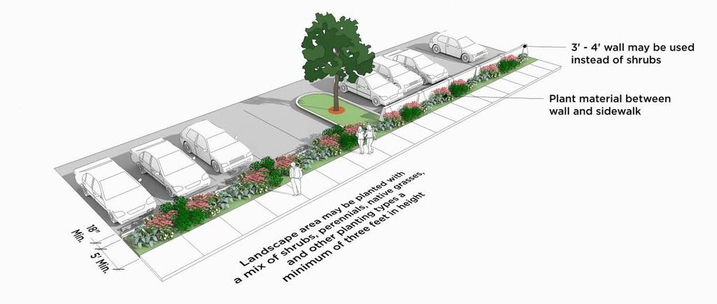
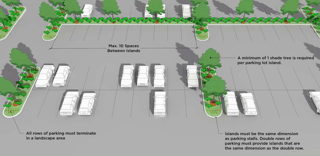
20 LANDSCAPE
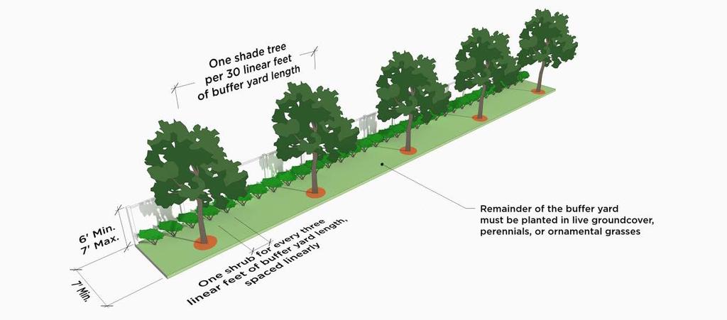
21 LANDSCAPE
22 PLANNED DEVELOPMENT Update the PD Process Include examples of public benefits & amenities Clarify that both dimensional & use standards of district may be modified Allow for administrative, minor, & major changes to approved PD Modify requirement for LEED certification: 1. Allow use of additional sustainability ratings systems in addition to LEED, such as the Sustainable Sites Initiative 2. Eliminate requirement for formal certification from a third party, but require evaluation to show that such standards have been met
23 ADMINISTRATION Reorganize administrative provisions Organize in three sections: 1. Ordinance administrators 2. Application procedures 3. Zoning approvals Create Zoning Administrator position Village Planner or his/her designee, including Zoning Officer Completeness review for submitted applications Submit application directly to recommending body Update approval standards for all approvals
24 ADMINISTRATION Eliminate use variations Variations only apply to dimensional standards Do not use to allow uses that are not allowed in the district Create administrative variation process Approved by Zoning Administrator 10% variation to dimensional standards Reduce off-street parking by 10% Vary bicycle parking Administrative variation notice to adjacent properties; written objections to be submitted before a date certain Any objection sends variation to ZBA Appeal decision to ZBA
25 NONCONFORMITIES Specifically address variety of nonconforming situations Nonconforming use Nonconforming structure Nonconforming site element Nonconforming lot
26 Zoning Technical Review Presented by Camiros November 10, 2015
UNIFIED DEVELOPMENT CODE
 Zoning UNIFIED DEVELOPMENT CODE Regulates how land is used Sets dimensional requirements for structures Addresses all aspects of site development: accessory structures, temporary uses, parking, landscape,
RESIDENTIAL DISTRICTS
 RESIDENTIAL DISTRICTS The residential district standards have been revised to reflect on-the-ground conditions, while continuing to respect the use patterns established within the neighborhoods. This will
TRANSFORM BALTIMORE NEW ZONING CODE. Laurie Feinberg, Asst. Director
 Laurie Feinberg, Asst. Director 4/5/2017 1 History and Summary of Process Principles of the code New Designations Use Tables Bulk Regulations Design and Landscape Guidelines Liquor Outlet Reduction Urban
TRANSFORM BALTIMORE NEW ZONING CODE
 Laurie Feinberg, Asst. Director 4/26/2017 1 History and Summary of Process Principles of the code New Designations Use Tables Bulk Regulations Design and Landscape Guidelines Liquor Outlet Reduction Urban
MIXED-USE VILLAGE OVERLAY FLOATING DISTRICT
 MIXED-USE VILLAGE OVERLAY FLOATING DISTRICT Zoning regulations developed by committee to the Planning Board for the Town of DeWitt, NY Issue date: 13 July 2017 revised 3/12/2018, revised 4/26/2018, 5/9/2018
SECTION UNIFIED DEVELOPMENT ORDINANCE SECTION Part 1 Ordinance. ARTICLE 1 Zoning Districts
 SECTION 1-100 UNIFIED DEVELOPMENT ORDINANCE SECTION 1-300 Part 1 Ordinance SECTION 1-100. Introduction. ARTICLE 1 Zoning Districts Crystal Lake strives to maintain a balance of various land uses for a
Agenda. Presentation (30 minutes) Overview of RIV District Next Steps / Calendar Display Stations. Display Station Discussion
 Overview of RIV District Next Steps / Calendar Display Stations. Display Station Discussion") Agenda Presentation (30 minutes) Overview of RIV District Next Steps / Calendar Display Stations Display Station Discussion RIV District Overview What is in the District? Purpose & Subdistricts Required
Agenda Presentation (30 minutes) Overview of RIV District Next Steps / Calendar Display Stations Display Station Discussion RIV District Overview What is in the District? Purpose & Subdistricts Required
City of San Ramon. Zoning Ordinance. Adopted: October 27, Latest Revisions Effective: March 28, 2018
 City of San Ramon Zoning Ordinance Adopted: October 27, 2015 Latest Revisions Effective: March 28, 2018 City of San Ramon 7000 Bollinger Canyon Road San Ramon, California 94583 [Page intentionally left
The broad range of permitted and special uses allowed in the district remain, but some descriptions have been clarified.
 Memorandum To: Emily Fultz, AICP City Planner, City of Edwardsville From: Michael Blue, FAICP Principal, Teska Associates Date: January 24, 2019 RE: B-1 Zoning District Update A draft, updated B-1 Central
LIST OF TABLES, FIGURES AND APPENDICES
 LIST OF TABLES, FIGURES AND APPENDICES Chapter Page 2 INTERPRETATION FIGURE 2.1 SAMPLE AWNING...2.8 FIGURE 2.2 SAMPLE LOW-RISE APARTMENT DESIGN...2.9 FIGURE 2.3 SAMPLE DUPLEX DESIGN...2.10 FIGURE 2.4 SAMPLE
PUD GUIDE FOR THE RED MOUNTAIN RANCH PLANNED UNIT DEVELOPMENT
 PUD GUIDE FOR THE RED MOUNTAIN RANCH PLANNED UNIT DEVELOPMENT Exhibit B to the Annexation and Development Agreement October 15, 2018 *Notes in red are intended for Town of Eagle review purposes and are
PINE CURVE REZONING. Property does not meet criteria for open space preservation and is not a candidate for a park
 PINE CURVE REZONING BACKGROUND Purchased as two parcels in 2001 and 2002 Annexed and Zoned Greater Downtown District Historic Center September 25, 2002 and October 7, 2002 WHAT THE PROJECT IS AND IS NOT
PINE CURVE REZONING. BACKGROUND Purchased as two parcels in 2001 and 2002
 BACKGROUND Purchased as two parcels in 2001 and 2002 WHAT THE PROJECT IS AND IS NOT A Rezoning establishes the land use standards for Annexed and Zoned Greater Downtown District Historic Center September
Today s Agenda. Introduction to Camiros. Introduction to Zoning. Overview of Project Process Current understandings What we ve heard so far
 Today s Agenda Introduction to Camiros Introduction to Zoning Overview of Project Process Current understandings What we ve heard so far Public Comment Camiros Key Personnel Arista Strungys, AICP, PP Principal
MONTGOMERY COUNTY PLANNING DEPARTMENT
 MONTGOMERY COUNTY PLANNING DEPARTMENT THE MARYLAND-NATIONAL CAPITAL PARK AND PLANNING COMMISSION MCPB Item No.: Date: 5-03-18 Pike and Rose, Phase I: Site Plan Amendment No. 82012002D Rhoda Hersson-Ringskog,
Noblesville Unified Development Ordinance Audit
 Noblesville Unified Development Ordinance Audit December 4 th, 2012 Shane Burkhardt, AICP RW Armstrong Project Summary Started project in the beginning of June 2012 Conducted focus groups July 2012 Conducted
4.1.3 LAND USE CATEGORIES
 4.1.3 LAND USE CATEGORIES a. City Center District The City Center District incorporates the existing character and mix of uses in downtown Belmont to encourage redevelopment and new development in keeping
Request Alternative Compliance to the prescribed criteria of the Oceanfront Resort District Form-Based Code. Staff Planner Kristine Gay
 Applicant/Owner Ocean Rental Properties, LLC Public Hearing April 13, 2016 City Council Election District Beach Agenda Item 1 Request Alternative Compliance to the prescribed criteria of the Oceanfront
17.11 Establishment of Land Use Districts
 17.11 Establishment of Land Use Districts 17.11.010 Purpose. To promote the health, safety, and general welfare of City residents and those who come to South Salt Lake to work, exchange commerce and recreate.
O Dell Parkway PUD Association, Inc. PO Box 1335
 CITY OF SOUTH BURLINGTON DEVELOPMENT REVIEW BOARD SD_14_06_F+MDevelopment_25BaconSt_sketch SKETCH PLAN REVIEW #SD-14-06 O DELL PARKWAY PUD DEPARTMENT OF PLANNING & ZONING Report preparation date: April
Chair Leskinen and Planning Commission Members Jessica Loftus, City Administrator
 Agenda Item 3 Date Application Received: 10/21/15 Date Application Considered as Complete: 10/30/15 120-Day Review Period Expires: 02/27/16 To: From: Chair Leskinen and Planning Commission Members Jessica
Town of Liberty, NY COMPREHENSIVE PLAN & ZONING UPDATES
 Town of Liberty, NY S Public Informational Meeting October 4, 2016 High School Auditorium Welcome Thank you for coming tonight. Agenda Part I Overview of Proposed Changes What is Being Prepared Anticipated
DRAFT Northeast Quadrant of Kipling Avenue and Highway 7 DRAFT AUGUST 29, Goals Land Use. The goals of this Plan are to:
 AUGUST 29, 2017 12.15 Northeast Quadrant of Kipling Avenue and Highway 7 12.15.1 Goals 12.15.2 Land Use The goals of this Plan are to: 12.15.2.1 General Provisions: a) Ensure the development of a compact
DRAFT DESIGN GUIDELINES
 IHZ Booklet #7 May 6, 2010 DRAFT DESIGN GUIDELINES CANTERBURY 7 Overview During the recent planning process for the Plan of Conservation and Development community character was identified as an important
Clarksburg Square Road Extension
 Clarksburg Square Road Extension Preliminary Plan No. 120140060 Site Plan No. 820140050 Site Plan Amendment No. 82007022C (Clarksburg Town Center) Clarksburg SPA Water Quality Plan Mandatory Referral MR2015008
CHAPTER SPECIAL PURPOSE AND OVERLAY ZONING DISTRICTS
 Special Purpose and Overlay Zoning Districts 106.28.010 CHAPTER 106.28 - SPECIAL PURPOSE AND OVERLAY ZONING DISTRICTS SPECIAL PURPOSE AND OVERLAY ZONING DISTRICTS Sections: 106.28.010 - Purpose 106.28.020
Be it enacted by the Town Board of the Town of Guilderland that the following new A (Transit Oriented Development (TOD) District) is adopted:
 District) is adopted:") Local Law No. 4 of 2018 (Adoption of 280-18A (Transit Oriented Development District) Be it enacted by the Town Board of the Town of Guilderland that the following new 280-18A (Transit Oriented Development
Local Law No. 4 of 2018 (Adoption of 280-18A (Transit Oriented Development District) Be it enacted by the Town Board of the Town of Guilderland that the following new 280-18A (Transit Oriented Development
PLANNED UNIT DEVELOPMENT STAFF REPORT Date: June 2, 2016
 # 9 ZON2016-01032 PLANNED UNIT DEVELOPMENT STAFF REPORT Date: June 2, 2016 DEVELOPMENT NAME JJT Properties LLC LOCATION 1147 & 1151 East I-65 Service Road South and 1180 Sledge Drive (Southeast corner
The Highway Overlay District applies to an area within the City of Papillion's zoning jurisdiction described as:
 ARTICLE XXVIII. HOD Highway Overlay District 205-164. Intent. The Highway Overlay District recognizes the strategic importance of the Highway 370 corridor as an entrance to Papillion from Interstate 80
1.0 Purpose of a Secondary Plan for the Masonville Transit Village
 Report to Planning and Environment Committee To: Chair and Members Planning & Environment Committee From: John M. Fleming Managing Director, Planning and City Planner Subject: Masonville Transit Village
City of Albuquerque. Integrated Development Ordinance (IDO) Training Development Standards. March 30 & April 4,
 Training Development Standards. March 30 & April 4,") City of Albuquerque Integrated Development Ordinance (IDO) Training Development Standards March 30 & April 4, 2018 www.abc-zone.com IDO Trainings FAQs by Topic March 21 & 23 March 30 & April 4 April 6
City of Albuquerque Integrated Development Ordinance (IDO) Training Development Standards March 30 & April 4, 2018 www.abc-zone.com IDO Trainings FAQs by Topic March 21 & 23 March 30 & April 4 April 6
1296 Kennedy Road - Zoning Amendment Application - Preliminary Report
 STAFF REPORT ACTION REQUIRED 1296 Kennedy Road - Zoning Amendment Application - Preliminary Report Date: January 15, 2016 To: From: Wards: Reference Number: Scarborough Community Council Acting Director,
Presentation of the Staff Draft. July 17, 2014 SSRVP Team, Area 3
 Presentation of the Staff Draft July 17, 2014 SSRVP Team, Area 3 Presentation Overview Introduction Plan Framework Plan Recommendations Implementation Next Steps and Request for Public Hearing on September
CONCEPT BRIEF. 101 West Abram Street Arlington, Texas
 CONCEPT BRIEF 101 West Abram Street Arlington, Texas 76010 817-459-6502 www.arlingtontx.gov/planning PD13-18 Case Number: Form must be filled out completely. Please type or legibly print all information.
Public Hearing, July 12, 2018
 Draft Lighting Ordinance Public Hearing, July 12, 2018 Planning and Development Services staff has developed a draft lighting ordinance for Winston-Salem and Forsyth County at the direction of the City-County
Area Plans. September 18, 2012
 Area Plans September 18, 2012 Transfer ratio for existing development up to 1:6 depending on sending parcel sensitivity and distance from community centers and/or transit routes. Within Town Center and
BE IT ORDAINED by the Board of Supervisors of Chesterfield County:
 Attachment A AN ORDINANCE TO AMEND THE CODE OF THE COUNTY OF CHESTERFIELD, 1997, AS AMENDED, BY AMENDING AND REENACTING SECTIONS 19.1-52, 19.1-53, 19.1-236, 19.1-247, 19.1-253, 19.1-263, 19.1-341, 19.1-346,
Glenborough at Easton Land Use Master Plan
 Implementation 114 9.0 IMPLEMENTATION 9.1 OVERVIEW This chapter summarizes the administrative procedures necessary to implement the proposed land use plan, infrastructure improvements, development standards,
City of Langford Green Development Checklist
 City of Langford Green Development Checklist The following Green Development Checklist creates a sustainability standard for all comprehensive development within the City of Langford. The commitments made
LAND USE OVERVIEW WHAT YOU WILL FIND IN THIS CHAPTER
 LAND USE WHAT YOU WILL FIND IN THIS CHAPTER Information about the City s expected population and employment growth. Description and capacity of existing and future land use designations. Policies that
2. Would the proposed project comply with the Land Use map? 3. Would the proposed project require a rezoning? 4. What is the proposed zoning district?
 TOWN OF CHAPEL HILL Planning and Sustainability Department 405 Martin Luther King Jr. Blvd. Chapel Hill, NC 27514 www.townofchapelhill.org phone (919) 9682728 Concept Plans are intended to be an opportunity
MONTGOMERY COUNTY PLANNING DEPARTMENT
 MONTGOMERY COUNTY PLANNING DEPARTMENT THE MARYLAND-NATIONAL CAPITAL PARK AND PLANNING COMMISSION MCPB Item No. Date: 04/05/2018 850 Sligo Avenue Sketch Plan No. 320180090 Neil Sullivan, Planner Coordinator,
SECTION TWO: Overall Design Guidelines
 SECTION TWO: Overall Design Guidelines This section provides overall design principles and guidelines for the Gardnerville Mixed-use Overlay. They provide criteria for mixed-use places consisting of residential,
VILLAGE OF CLEMMONS PLANNING BOARD DRAFT STAFF REPORT
 VILLAGE OF CLEMMONS PLANNING BOARD DRAFT STAFF REPORT PETITION INFORMATION Docket # C-226 Staff Megan Ledbetter Petitioner(s) JBJH Properties, LLC Owner(s) JBJH Properties, LLC Subject Property 5892-49-1766
Mitchell Ranch South MPUD Application for Master Planned Unit Development Approval Project Narrative. Introduction
 Mitchell Ranch South MPUD Application for Master Planned Unit Development Approval Project Narrative Introduction Mitchell Ranch South is a proposed single family (detached) residential development on
A. Reducing noise pollution, air pollution, and visual pollution;
 A well designed landscape, when made an integral part of a development plan, provides aesthetic appeal and makes an important contribution to the health, safety, and general welfare of the community by:
5.1 Site Plan Guidelines
 5. Community Core Guidelines Development of the Community Core will take place by plan of subdivision and site plan approval. It will occur in a phased manner that will reflect the timing of residential
4 Residential and Urban Living Zones
 4 Residential and Urban Living Zones Refer to Chapters 11 to 20 for additional rules that may apply to these zones. 4.1 OBJECTIVES AND POLICIES Objective Res1 Policy 1 Policy 2 Policy 3 Policy 4 Policy
KENDALL SQUARE INITIATIVE. Planned Unit Development Special Permit Application - SoMa September 8, 2015
 KENDALL SQUARE INITIATIVE Planned Unit Development Special Permit Application - SoMa September 8, 2015 GENERAL DEVELOPMENT GOALS Kendall Square PUD 2 PRE-ZONING PUBLIC ENGAGEMENT 2008-2009 2010-2012 2013
30 and 44 Zorra Street - Zoning By-law Amendment Application - Preliminary Report
 STAFF REPORT ACTION REQUIRED 30 and 44 Zorra Street - Zoning By-law Amendment Application - Preliminary Report Date: March 14, 2016 To: From: Wards: Reference Number: Etobicoke York Community Council Director,
CITY OF PUYALLUP. Background. Development Services
 CITY OF PUYALLUP Development Services 333 South Meridian Puyallup WA 98371 To: City Council From: Katie Baker, AICP, Planning Division Re: South Hill Neighborhood Plan Adoption Date: (Meeting date: February
2. Would the proposed project comply with the Land Use map? 3. Would the proposed project require a rezoning? 4. What is the proposed zoning district?
 TOWN OF CHAPEL HILL Planning and Sustainability Department 405 Martin Luther King Jr. Blvd. Chapel Hill, NC 27514 www.townofchapelhill.org phone (919) 968 2728 Concept Plans are intended to be an opportunity
3.1 community vision. 3.3 required plan elements
 Chapter 3 Community Form 3.1 community vision 3.2 Parks & landscaping concepts 3.3 required plan elements D R A F T 20 Community Form Chapter 3 3.0 Community form 3.1 community vision The Specific Plan
Prince George s County, Maryland
 Executive Summary of Module 2 May 2016 Division 27-5: Development Standards Division 27-8: Interpretation and Definitions Division 24-3: Subdivision Standards (Adequacy of Public Facilities) Division 24-6:
Staff Report to the North Ogden City Planning Commission
 Staff Report to the North Ogden City Planning Commission SYNOPSIS / APPLICATION INFORMATION Application Request: Concept review on a legislative application to rezone land located at approximately 1750
Zoning Interface: Districts and Forms for Sioux Falls Zoning Ordinance
 Zoning Interface: Districts and Forms for Sioux Falls Zoning Ordinance For more information about each form, click on the associated link. Single-Family Residential Districts RR Rural Residential RS Single-Family
2018 AMENDMENT TO THE COMPREHENSIVE PLAN
 2018 AMENDMENT TO THE COMPREHENSIVE PLAN AND LAND USE REGULATORY CODE Summary of Proposed Amendments A Plan or Code Amendment is the process through which the City considers changes, additions, and updates
WEST LOOP DESIGN GUIDELINES CHECKLIST
 WEST LOOP DESIGN GUIDELINES CHECKLIST Section 1.0 General Strategies 1.1 DESIGN EXCELLENCE: ENCOURAGE HIGH QUALITY AND INNOVATIVE DESIGN OF NEW BUILDINGS WITHIN THE WEST LOOP WITHOUT BEING PRESCRIPTIVE
Gold Line Bus Rapid Transit Transit Oriented Development (BRTOD) Helmo Station Area Plan
 Helmo Station Area Plan") Appendix F Gold Line Bus Rapid Transit Transit Oriented Development (BRTOD) Helmo Station Area Plan Introduction and Purpose of the Plan The Gold Line Bus Rapid Transit facility is an eleven-mile dedicated
Appendix F Gold Line Bus Rapid Transit Transit Oriented Development (BRTOD) Helmo Station Area Plan Introduction and Purpose of the Plan The Gold Line Bus Rapid Transit facility is an eleven-mile dedicated
Attachment 1 TOWN OF NEW TECUMSETH. Manual for the Preparation of an Urban Design Report
 Attachment 1 TOWN OF NEW TECUMSETH Manual for the Preparation of an Urban Design Report July 2010 TABLE OF CONTENTS Background, Policy Framework and the Preparation of Urban Design Reports 1. Introduction
FUTURE LAND USE ELEMENT
 FUTURE LAND USE ELEMENT GOAL I: To create and sustain a great place to live, play, and prosper Objective 1: The City of Ocala shall incorporate the principles and strategies of the Ocala 2035 Vision into
Planned Development Review Revisions (Project No. PLNPCM )
") Planned Development Review Revisions (Project No. PLNPCM2014-00139) Standard residential development Planned Development Example: Smaller lot sizes than what is allowed to create open space amenity. What
Planned Development Review Revisions (Project No. PLNPCM2014-00139) Standard residential development Planned Development Example: Smaller lot sizes than what is allowed to create open space amenity. What
PLANNED UNIT DEVELOPMENT Date: April 5, 2018
 PLANNED UNIT DEVELOPMENT Date: April 5, 2018 DEVELOPMENT NAME SUBDIVISION NAME LOCATION Robert Myers Robert Myers 2955 and 2989 Dauphin Street (Southeast corner of Dauphin Street and Sage Avenue) CITY
CONTENTS 8.0 LAND USE 8.1 GENERAL LAND USE 8.2 RESIDENTIAL 8.3 MIXED USE 8.4 COMMERCIAL 8.5 EMPLOYMENT LANDS
 8-2 Land Use 8.0 LAND USE CONTENTS 8.1 GENERAL LAND USE 8.1.1 Uses provided for in all Land Use Designations 8.1.2 Uses prohibited in Hazardous Lands, Hazardous Sites and Special Policy Areas 8.1.3 Uses
Draft Cary Community Plan Review Part 3: Shop, Engage, Serve, Special Area Plans, Other Updates. October 27, 2015 Police Department Training Room
 Draft Cary Community Plan Review Part 3: Shop, Engage, Serve, Special Area Plans, Other Updates Committee for the Future October 27, 2015 Police Department Training Room AGENDA 1. Welcome and Call to Order
KENDALL SQUARE INITIATIVE. Planned Unit Development Special Permit Application - SoMa September 8, 2015
 KENDALL SQUARE INITIATIVE Planned Unit Development Special Permit Application - SoMa September 8, 2015 GENERAL DEVELOPMENT GOALS Kendall Square PUD 2 PRE-ZONING PUBLIC ENGAGEMENT 2008-2009 2010-2012 2013
EXHIBIT A. Chapter 2.7 SPECIAL PLANNED DISTRICTS. Article XVIII 15th Street School Master Planned Development
 EXHIBIT A Chapter 2.7 SPECIAL PLANNED DISTRICTS Article XVIII 15th Street School Master Planned Development Sections: 2.7.3600 15 th Street School Master Planned Development 2.7.3610 Purpose 2.7.3620 Definitions
New Town Mixed Use District
 New Town Mixed Use District Montgomery County Planning Commission 2009 Annual Conference PA Chapter of the American Planning Association October 6, 2009 What is NTMU? More urban style of development Complementary
5959 Yonge Street Rezoning Application - Preliminary Report
 STAFF REPORT ACTION REQUIRED 5959 Yonge Street Rezoning Application - Preliminary Report Date: February 23, 2011 To: From: Wards: Reference Number: North York Community Council Director, Community Planning,
240 and 242 Finch Avenue West Zoning By-law Amendment Application Preliminary Report
 REPORT FOR ACTION 240 and 242 Finch Avenue West Zoning By-law Amendment Application Preliminary Report Date: March 1, 2019 To: North York Community Council From: Director, Community Planning, North York
MONTGOMERY COUNTY PLANNING DEPARTMENT THE MARYLAND-NATIONAL CAPITAL PARK AND PLANNING COMMISSION
 MONTGOMERY COUNTY PLANNING DEPARTMENT THE MARYLAND-NATIONAL CAPITAL PARK AND PLANNING COMMISSION MCPB Item No. Date: 3.10.2016 Site Plan 820160040 Nora School Parker Smith, Planning Technician, Area 1,
ORDINANCE AN ORDINANCE TO ADD A NEW SECTION 4.N. IN THE ZONING CODE FOR THE TOWN OF MIDDLETOWN, RELATING TO MIXED-USE DEVELOPMENT
 Introduced: November 5, 2018 Approved: ORDINANCE 18-11-01 AN ORDINANCE TO ADD A NEW SECTION 4.N. IN THE ZONING CODE FOR THE TOWN OF MIDDLETOWN, RELATING TO MIXED-USE DEVELOPMENT BE IT ENACTED BY THE MAYOR
Village of Glenview Plan Commission
 Village of Glenview Plan Commission STAFF REPORT January 22, 2019 TO: Chairman and Plan Commissioners CASE #: P2018-047 FROM: Community Development Department CASE MANAGER: Tony Repp, Senior Planner SUBJECT:
This page intentionally left blank
 This page intentionally left blank Table of Contents I. INTRODUCTION AND OVERVIEW... I-1 II. DIAGNOSIS... II-1 Theme 1. Create a User-Friendly Code... II-1 1.1 Make the Structure and Format More Logical
BOULEVARD AND PARKWAY STANDARDS
 88-323 BOULEVARD AND PARKWAY STANDARDS 88-323-01 PURPOSE Considerable public and private investment exists and is expected to occur adjacent to boulevards and parkways within the city. The following standards
B L A C K D I A M O N D D E S I G N G U I D E L I N E S for Multi-family Development
 B L A C K D I A M O N D D E S I G N G U I D E L I N E S for Multi-family Development Adopted June 18, 2009 This section of the Design and focuses on site planning and design guidance for new multi-family
4. Shape Transitions. 4. Shape Transitions
 4. Shape Transitions 49 Zoning District Policies Overall Intent: Maintain neighborhood character by creating compatible transitions that minimize land use conflicts. Strategy: Define the character of zoning
Request Conditional Rezoning (R-15 Residential to Conditional A-24 Apartment) Staff Recommendation Approval. Staff Planner Jimmy McNamara
 Staff Recommendation Approval. Staff Planner Jimmy McNamara") Applicant Franklin Johnston Group Management & Development, LLC Property Owner Virginia Wesleyan College Public Hearing July 12, 2017 City Council Election District Bayside Agenda Item 3 Request Conditional
Applicant Franklin Johnston Group Management & Development, LLC Property Owner Virginia Wesleyan College Public Hearing July 12, 2017 City Council Election District Bayside Agenda Item 3 Request Conditional
FORMER CANADIAN FORCES BASE (CFB) ROCKCLIFFE SECONDARY PLAN. Official Plan Amendment XX to the Official Plan for the City of Ottawa
 ROCKCLIFFE SECONDARY PLAN. Official Plan Amendment XX to the Official Plan for the City of Ottawa") FORMER CANADIAN FORCES BASE (CFB) ROCKCLIFFE SECONDARY PLAN Official Plan Amendment XX to the Official Plan for the City of Ottawa 1 INDEX THE STATEMENT OF COMPONENTS PART A THE PREAMBLE PAGE Purpose...
FORMER CANADIAN FORCES BASE (CFB) ROCKCLIFFE SECONDARY PLAN Official Plan Amendment XX to the Official Plan for the City of Ottawa 1 INDEX THE STATEMENT OF COMPONENTS PART A THE PREAMBLE PAGE Purpose...
COUNTY COUNCIL OF PRINCE GEORGE'S COUNTY, MARYLAND SITTING AS THE DISTRICT COUNCIL 2010 Legislative Session. Council Members Dernoga and Olson
 DR- COUNTY COUNCIL OF PRINCE GEORGE'S COUNTY, MARYLAND SITTING AS THE DISTRICT COUNCIL 00 Legislative Session Bill No. CB--00 Chapter No. Proposed and Presented by Introduced by Co-Sponsors The Chairman
Wadsworth Boulevard S TAT I O N A R E A P L A N
 Wadsworth Boulevard S TAT I O N A R E A P L A N City of Lakewood Adopted November, 2006 The Vision The City of Lakewood s overall vision is to transform the area around the light rail station into a mixed-use
Landscaping Standards
 CHAPTER 29 ARTICLE 403 29.403 Landscaping Standards Purpose: The purpose of this section is to protect and promote the public health, safety and general welfare by requiring landscaping in relation to
ROLL CALL Member Anthony, Member Avdoulos, Member Greco, Member Lynch, Member Maday, Chair Pehrson
 CALL TO ORDER The meeting was called to order at 7:00 PM. PLANNING COMMISSION ACTION SUMMARY CITY OF NOVI Regular Meeting July 11, 2018 7:00 PM Council Chambers Novi Civic Center 45175 W. Ten Mile (248)
FLORIN ROAD CORRIDOR Site Plan and Design Review Guidelines Checklist
 FLORIN ROAD CORRIDOR Site Plan and Design Review Guidelines Checklist Applicant s Name: Project Address: Phone: Email: Applicant shall fill out the design guidelines checklist for all guidelines applicable
What Does It Take To Create A Town Center?
 What Does It Take To Create A Town Center? Context, Design, and Process The Prince Frederick Master Plan Update 1 Background and Overview A Brief History of Town Centers in Calvert County 2 Background
TRANSIT ORIENTED DEVELOPMENT PINELLAS COUNTY MPO LIVABLE COMMUNITIES INITIATIVE PINELLAS COUNTY COMPREHENSIVE PLAN AMENDMENTS
 PINELLAS COUNTY MPO LIVABLE COMMUNITIES INITIATIVE MODEL LAND DEVELOPMENT CODE TRANSIT ORIENTED DEVELOPMENT PINELLAS COUNTY COMPREHENSIVE PLAN AMENDMENTS MPO Livable Communities Initiative Goal: Improve
Sketch Plan. MNCPPC Plan No: A
 General Notes 1. The Sketch Plan drawings are conceptual only and represent proposed development in an illustrative manner. Final building locations, dimensions, heights, uses and development standards
Quarterly Report & Code Evaluation
 A New Zoning Code for a 21st Century Los Angeles To create livable communities, encourage sustainable development and foster economic vitality, we need a modern and user-friendly zoning code we need to
Appendix D North Road/N. Leroy Street Subarea Plan
 North Road/N. Leroy Street Subarea Plan INTRODUCTION The City of Fenton Master Plan was updated in 1996 and included a subarea plan for the North Leroy Street area of the City. It was recognized at that
Working with Local Government to create Community Gardens
 Working with Local Government to create Community Gardens Zero Waste Local Food Renewable Energy Land Use Energy /Water Efficiency Transit, Bike & Pedestrian Mobility FOOD SECURITY Local Food ENVIRONMENTAL
E. RURAL COMMERCIAL/INDUSTRIAL PARK MODEL
 E. RURAL COMMERCIAL/INDUSTRIAL PARK MODEL 1. PURPOSE The purpose of the Rural Commerce/Industrial Park Model is to provide parameters within which a grouping of business buildings with parking, loading
Horizon 2035 Land Use and Transportation Element
 CITY OF SUNNYVALE Horizon 2035 Land Use and Transportation Element City Council Study Session March 7, 2017 Overview General Plan Context Mixed Use Villages Transportation Mode & Parking General Plan Policy
 May 31 st, 2018 Mr. Matthew Dickison City of Chamblee 3506 Broad Street Chamblee, GA 30341 RE: Variance Application/5368 and 5370 Peachtree Road, Chamblee, GA 30341 (Eugenia s Hardware) Mr. Dickison, Please
Major Subdivision Sketch Plan Checklist
 This checklist provides specific requirements that are apart of the Sketch process. The entire process is described by the Huntersville Subdivision Review Process which details all the submittal and resubmittal
CHAPTER 20: INSTITUTIONAL USE DEVELOPMENT STANDARDS
 CHAPTER 20: INSTITUTIONAL USE DEVELOPMENT STANDARDS ARTICLE 1: GENERAL INSTITUTIONAL USE STANDARDS 320-01. Application The provisions of this Chapter shall apply to the following uses in any zone: (e)
Appendix C: Interim Mixed-Use Evaluation Criteria
 Appendix C: Interim Mixed-Use Evaluation Criteria C-1 Appendix C: Interim Mixed-Use Evaluation Criteria PURPOSE: The implementation of numerous policies contained within the Master Plan hinges on the creation
CHAPTER ADDITIONAL REQUIREMENTS IN THE NC, NEIGHBORHOOD COMMERCIAL ZONE
 CITY OF MOSES LAKE MUNICIPAL CODE CHAPTER 18.31 ADDITIONAL REQUIREMENTS IN THE NC, NEIGHBORHOOD COMMERCIAL ZONE Sections: 18.31.010 Purpose 18.31.020 Minimum Lot Area 18.31.030 Setbacks 18.31.040 Maximum
WHEREAS, after consideration of the evidence presented at the public hearing on January 14, 2010, the Prince George's County Planning Board finds:
 R E S O L U T I O N WHEREAS, the Prince George s County Planning Board has reviewed DDS-600 requesting a departure for the location of two loading spaces without driveway access along Toledo Terrace in
Zoning Code Issues Prioritization
 City of Streetsboro The City of Streetsboro has begun the process of updating its Zoning Code. The new Zoning Code will be based on the recently adopted Comprehensive Plan, which establishes the overall
Director, Community Planning, North York District
 STAFF REPORT ACTION REQUIRED 36 and 37 Jane Osler Boulevard and 42 and 44 Cartwright Avenue Zoning By-law Amendment and Draft Plan of Subdivision Approval Applications - Preliminary Report Date: May 22,