Keystone Business Park Precinct Structure Plan North East Industrial Precinct. Part 2 Design Principles
|
|
|
- Hugh Todd
- 5 years ago
- Views:
Transcription

1 Keystone Business Park Precinct Structure Plan North East Industrial Precinct Part 2 Design Principles
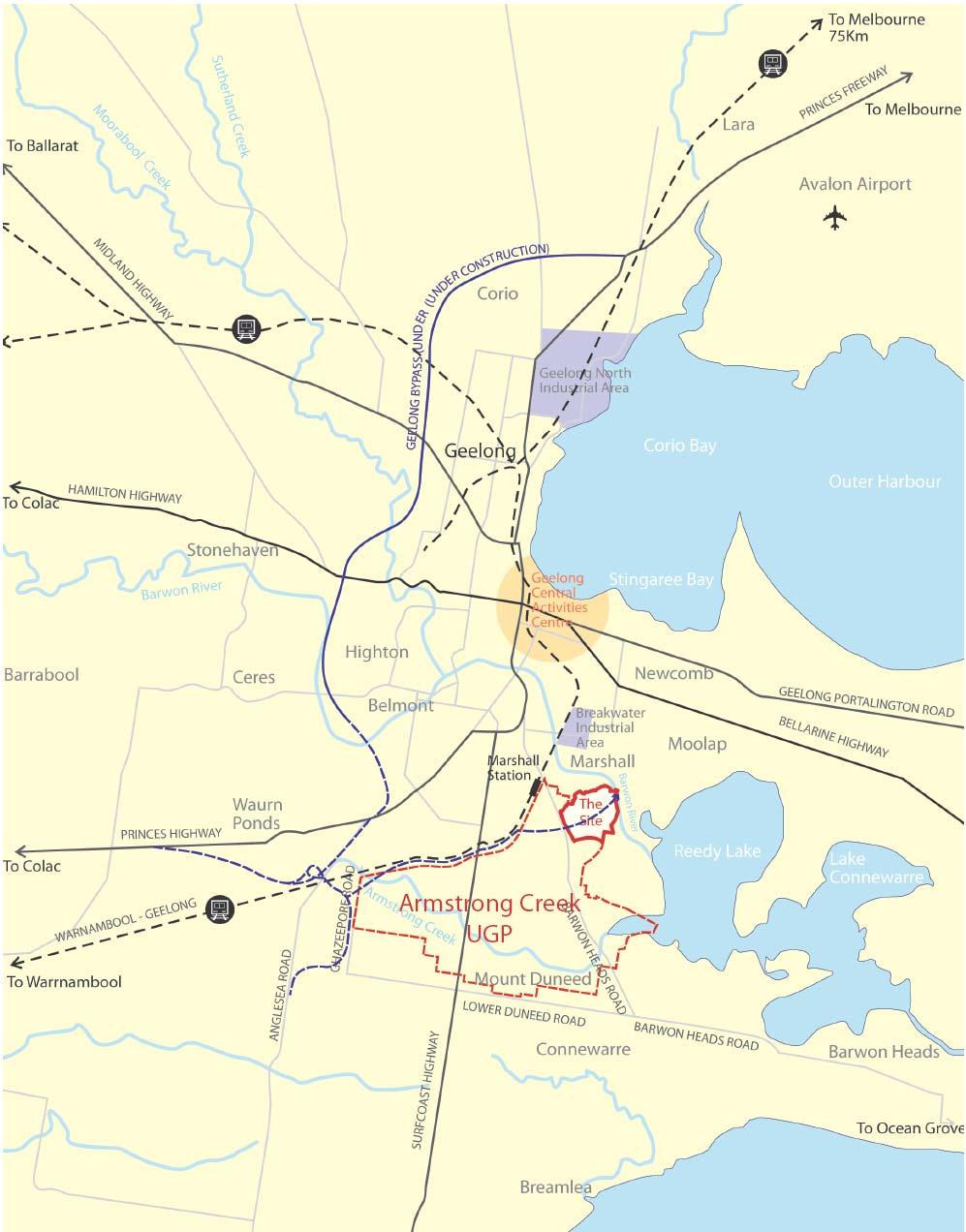
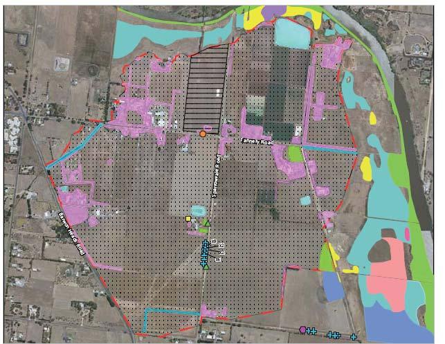
2 Context

3 Issues Services Landform


4 Issues Geotech and contamination Ecology Traffic and access


5 Issues Flooding and Drainage Heritage

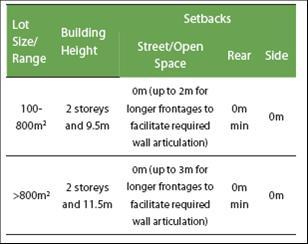
6 Issues Geotech and contamination


7 Design Principles Structure Plan Built Form Traffic & Transport Public Transport Pedestrian & Cycle Natural Environment Open Space Cultural Heritage Community Infrastructure Flooding and Drainage

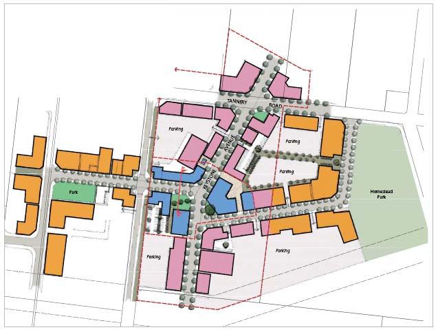
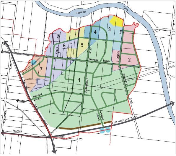
8 Precinct Structure Plan
9 Precinct Structure Plan Design Rationale The structure plan design has been assembled based on the following: the creation of an employment community of 8000 people to service the future growth of the Armstrong Creek area. a village centre that is located centrally to deliver the specialized activities identified in the UGP within walking distance of the as much as the NEIP area as possible. the distribution of land use, and design of the public realm that allows for the most intense uses (mixed use and fine-grain), to be located within the village centre and village framework to support the economic and social outcomes of creating a diverse village hub. Conversely the larger users are located surrounding the village centre within the industry and campus business precincts. A layout that takes into account staging of infrastructure and landholder boundaries and land ownership. The delivery of infrastructure based on current service capacity whilst allowing for future alternative infrastructure such as recycled water, clean energy and high-tech communications. an interconnected street network that allows for the separation and circulation of heavy traffic to the larger user precincts and an internal spine for medium to smaller vehicles that suit a more pedestrianised environment. A street network that is transit ready and has capacity for future public transport systems, envisaged in the UGP
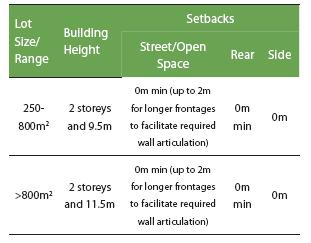
10 A street layout that terminates vistas at social gathering places (parks) and allows for termination of views on key sites with exemplar built form outcomes. The location of a campus business precinct fringing the Barwon River Corridor taking advantage of the open space amenity and the ability to front the Barwon River with a landscape setting and/or buildings. A pedestrian oriented development with street design that promotes walkability and links to open space, activity centres, and the broader community. Off-road and on-road cycleway provision that allows: east-west links to the Barwon River Corridor through the proposed Village Centre to Marshalltown Rd. links across Barwon Heads Rd and the future east-west link rd via signalized intersections. An off-road cycleway that circles the whole of the NEIP and links to external future pathways such as the aqueduct over the Barwon River and Enviro Track proposed along the Barwon River. Sustainable drainage and WSUD principles that are integrated into street and open space networks The delineation of open space that respects the heritage of the area as well providing identifiable places for active and passive recreation, framed by the built form. Heritage and cultural interpretation are to be weaved into the public realm. Interface treatments that provide quality built form and landscape front doors to major external roads and the Barwon River Corridor
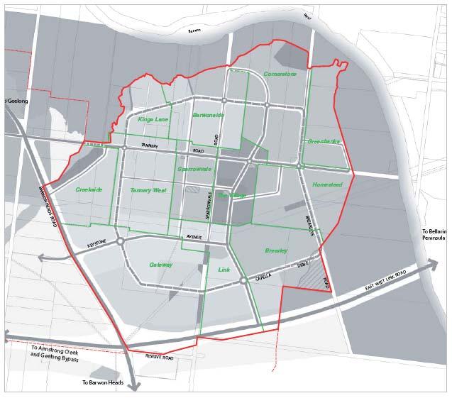
11 Draft Master Plan To inform the feasibility of the Precinct Structure Plan, a detailed Master Plan has been prepared to demonstrate a likely development outcome and determine expected floor space provisions.
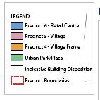
12 PSP Structure PSP has been designed to be implemented by ensuring the following key elements are delivered in the desired outcome: Employment and Specialized Activity Centre Image and Character Local Service Nodes Development Precincts 1-6 Subdivision Transport and Movement Open Space Biodiversity Heritage Drainage and Flooding Utilities and Energy
13 PSP Structure Each element includes: Vision Statement Objectives: an objective describes the desired outcome to be achieved in the completed development. Implementation Strategies which tell you to assess development form against the NEIP structure plan and a set of planning and design guidelines. Planning and Design Guidelines: planning and design guidelines including figures and tables that: Must be met; or Should be met. If the responsible authority is satisfied that an application for an alternative to a planning and design guideline that should be met, meets the relevant objective(s), the alternative may be considered to the satisfaction of the responsible authority. The above elements define the desired outcomes for each precinct Land use types also define precincts
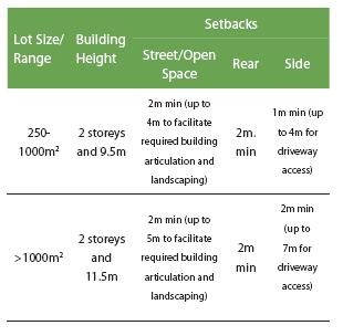
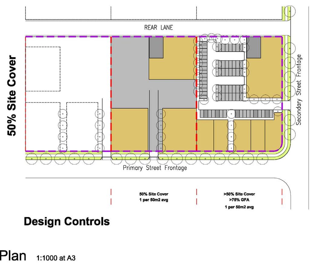
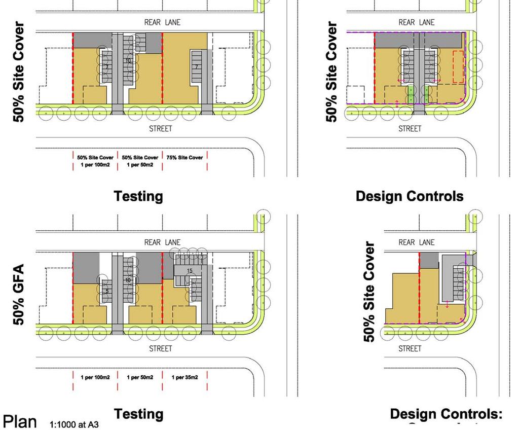
14 PSP Structure Planning and Design Guidelines These identify the key controls that will achieve the desired urban outcome set out in the objectives and vision. These are articulated through specific controls, figures and desired outcome statements. Example Section 5.3 Image and Character: Section 5.3, the key control is external wall articulation. The planning and design guideline provides a detailed description of articulation types. The following requirements establish minimum standards of building articulation for walls fronting public streets and open spaces. Articulation refers to: varying the setback from wall to property boundary by recessing parts of the wall to allow for landscaped areas to screen the wall; and/or incorporating large areas of glazing; and/or providing pedestrian entrances to the building that are clearly expressed as a design feature; and/or incorporating architectural features or details into the wall such as expressed pillars, architectural screens, and varying building materials and colours. A combination of these treatments is preferred; varying the colour of the wall only is not acceptable.
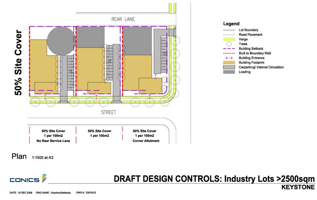
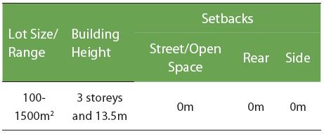
15 It then defines this further and how this must be achieved: Incorporate articulation throughout the full length of the wall. Ensure that the following wall lengths without articulation are not exceeded: Precinct 1 - Industry 8m Precinct 3 - Mixed Industry and Business Area 3m Precinct 4 - Village Frame 3m Ensure that the following the percentage of total wall area that is contained in a single section of blank wall (ie. has no articulation) is not exceeded: Precinct 6 - Retail Centre 15% Precinct 5 - Village 30% Precinct 2 - Campus Business 15%
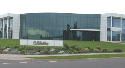
16 Unacceptable Acceptable

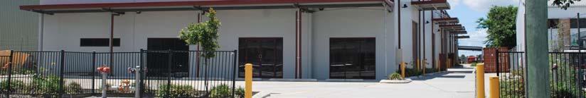
17 Precinct 1 - Service Industry larger grain service industry larger spatial requirements/larger vehicles/larger business service industry requiring less amenity less employment density/m2 TYCO: Fire Protection Services Safety Products Flow Control Electrical and Metal Products
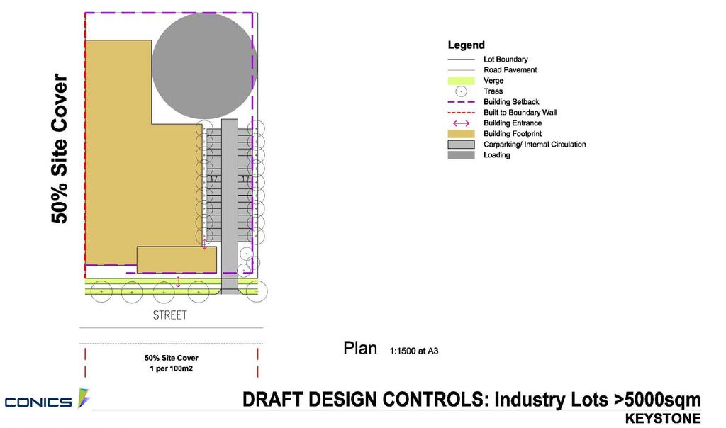
18 PSP Structure Precinct 1 Industry North and South Planning and Design Guidelines General Intent - THIS DESCRIBES THE URBAN INTENT AND PROVIDES MAJOR DESCRIPTIVE DIFFERENCES BETWEEN THE PRECINCTS Streetscape Private Landscape Lot Access Built Form and Architecture Signs Gateways and Sub-Precincts Interfaces - With Barwon Heads Road Interfaces - With the East-west Link Interfaces - With the Barwon River Corridor Car Parking and Service Areas
19
20
21 Car Parking and Service Areas Include on-street parking spaces along the allotment frontage in assessing on-site parking provision (on-site parking provision is the parking rate for the use, less the number of spaces available onstreet). This excludes sections of street frontages where there are driveway crossovers. For the purposes of this calculation, the length of a car parking space on-street is taken to be 7m. Where a lot has access to a rear lane, provide access to parking, servicing and loading areas from the rear lane in preference to the public street. Locate car parking, service and loading areas behind the buildings at either the side or the rear of the lot. Screen servicing and loading areas from primary frontages with buildings or landscaping.


22 Unacceptable Acceptable

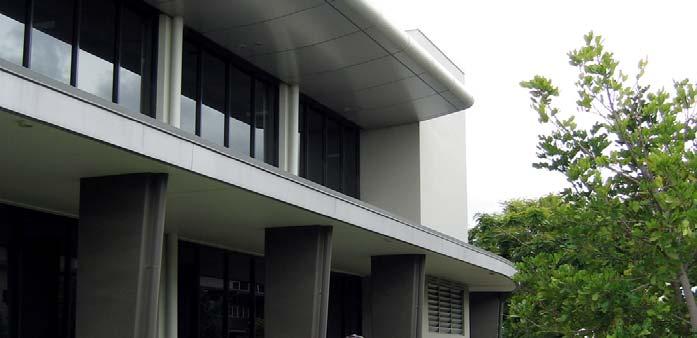
23 Precinct 2 - Campus Business Business with high employment ratio including highly skilled workers High amenity landscape and built form Different business address to service industry High quality employment amenities on-site Michael Hill Jeweller: office, manufacturing and design of jewellery


24 Precinct 2- Campus Business Filtronic telecommunications manufacturer 75% office (R&D), design, administration), 25% storage/showroom
25 PSP Structure Precinct 2 Campus Business Planning and Design Guidelines General Intent Streetscape Private Landscape Built Form and Architecture Signs Gateways and Sub-Precincts Interfaces with the Barwon River Corridor Car Parking and Service Areas

26 General Intent The following planning and design guidelines must be met: Encourage tenancies which are medium to large scale. Design buildings facades more akin to an office or commercial building. Design multistorey buildings so that they visually read as layered structures. Design buildings with regular, generous spacing between. Provide a high quality landscaped setting for the buildings. Connect the office or most active component of the land use to the street and open space (including the Barwon River corridor) where applicable. Front the primary building entrance to the primary street frontage. Design buildings to overlook the street and adjoining open space. Design buildings which address the Barwon River corridor, overlook the corridor, and have outdoor recreational areas facing the corridor Define entrances and clearly delineate access pathways to the street and / or open spaces with footpaths. These significantly differ from other precincts

27 Unacceptable Acceptable


28 Precinct 3 - Mixed Business and Industry Medium sized business and industry Finer grained uses that do not require large land Require a public front more than Service Industry Growth zone for industry and business incubation/strata title Synergies with other industry and business feed off each other Wholesale/retail crossover Clegg Media - servicing the advertising industry with the full range of outdoor advertising products and point of sale material. Active Medical Supplies artificial limbs to hospital beds
29 PSP Structure Precinct 3 Mixed Service industry and Business Planning and Design Guidelines General Intent Streetscape Private Landscape Lot Access Built Form and Architecture Signs Gateways and Sub-Precincts Interfaces with Barwon Heads Road Car Parking and Service Areas
30

31 MIBA Buildings with parking and loading in front flip this to have buildings fronting the street and most parking and loading at side or rear.


32 Unacceptable Acceptable


33 Precinct 4 - Village Frame East and West a mix of MIBA and Village Centre transition zone of higher service industry activity creates robustness
34 PSP Structure Precinct 4 Village Frame East and West Planning and Design Guidelines General Intent Streetscape Private Landscape Lot Access Built Form and Architecture Signs Gateways and Sub-Precincts Car Parking and Services Areas
35


36 Precinct 5 - Village finer grain most intense people activity services the whole of the NEIP Management and everyday NEIP needs Community services
37 PSP Structure Precinct 5 Village Planning and Design Guidelines General Intent Streetscape Private Landscape Lot Access Built Form and Architecture Signs Gateways and Sub-Precincts Car Parking and Service Areas

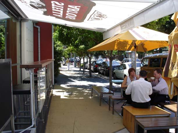
38 General Intent The following planning and design guidelines must be met: Encourage tenancies and land uses which are small scale and occupy small sections of street frontage allowing many uses to present to the street. Locate buildings to directly front the street boundary with no setback. Design buildings with zero side setbacks to provide continuous facades to streets. Openings between buildings are permitted for vehicle and pedestrian access into the site and to ensure adequate passive surveillance of internal parking areas from the street or open space. Design ground levels of buildings to activate the street, with window display areas and pedestrian entrances onto the street, plaza or open space.


39
40
41


42 Precinct 6 Retail Centre finer grain most intense people activity services the whole of the NEIP Management and everyday NEIP needs Community services
43 Objectives To provide retail to serve the professional and personal needs of the local worker population. To provide a centrally located centre within a 5 to 10 minute walk (defined as a m walkable catchment) of almost all workplaces. To ensure retail does not exceed a total floorspace of 2,800sqm. To provide a high quality, pedestrian prioritised street environment and awnings over the footpath. To provide land for convenience level retail (not exceeding 2,800sqm of retail floorspace) Provide land for entertainment facilities. Provide land for child care and medical centres to support the daily needs of the workers. Provide land for cafés and restaurants. Provide land for shop-top housing, serviced apartments and other forms of residential accommodation that can be integrated at an upper level into a convenience centre. Provide land for service industry and trade supplies that can be accommodated in a finer grain form (small scale, small floor area, small street frontage) and high amenity environment. Provide land for small offices providing personal and professional services to the working population and premises.


44 Unacceptable Acceptable


45 Local Nodes Café/Restaurant, Local convenience milk, bread, newsagent, dry-cleaning Passive public area
46 Traffic and Transport Pedestrian and Cycle
47 Traffic and Transport Key vehicle access to major roads and the broader network. Street design to separate heavy vehicle and local traffic Integrated street design to cater for expected traffic generation, pedestrians and cyclists, service location, landscape and WSUD. Links to existing railway station Public bus routes Corporate bus services Green vehicle intiatives Cycle and pedestrian routes Provision of essential services at Keystone such as Child Care facilities, fitness centres, banks and essential local shopping and business needs.
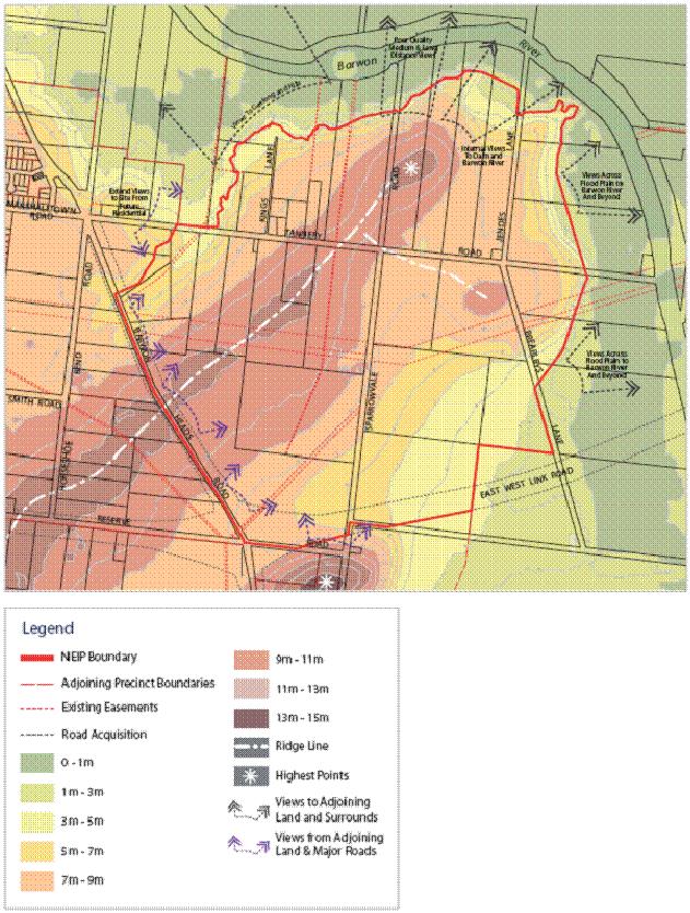
48 Entry Roads/Avenues
49 External Roads East West Link Road Barwon Heads Rd
50

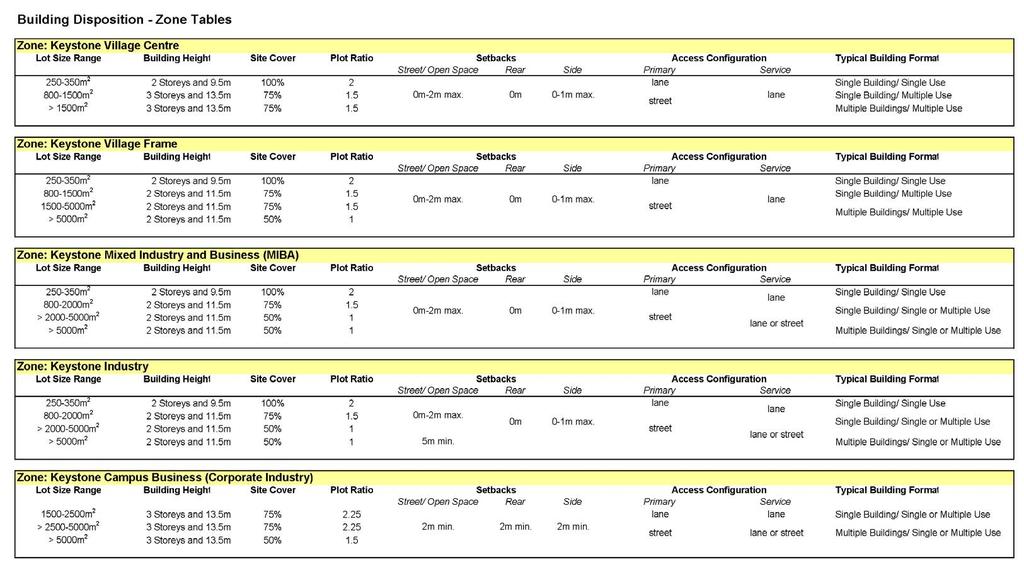
51 Open Space
52 Biodiversity
53 WSUD
54 Staging


55 Edge Treatments The Barwon River Corridor will become the front address form more than 50% of the perimeter of the NEIP. Buildings must front the Barwon River Corridor with pedestrian and/or vehicle access around the perimeter.
56 North-west open space and residential interface: The width of this open space ranges from approximately 20m to 100m. Screen planting within the open space and street trees along the proposed local road in the NEIP. Land uses must demonstrate no adverse impact on the future residential amenity in relation to noise, lighting, air quality and operation of business. Built form will be limited to 2 storeys along this edge.


57 Built Form Guidelines Owners Corporation High quality architecture, correctly scaled and proportioned Prominent sites are occupied by landmark buildings. Building design guidelines will establish contemporary architectural themes incorporating an expression of energy-efficient building design. Green Building requirements
58 Building Disposition
59 Vision Plan
I615. Westgate Precinct
 I615. Westgate Precinct I615.1. Precinct Description The Westgate Precinct is located approximately 18km west of the Auckland city centre. There are seven Sub-precincts in the Westgate Precinct: Sub-precinct
URBAN DESIGN BRIEF URBAN DESIGN BRIEF 721 FRANKLIN BLVD, CAMBRIDGE August 2018
 URBAN DESIGN BRIEF URBAN DESIGN BRIEF 721 FRANKLIN BLVD, CAMBRIDGE August 2018 DESIGN BRIEF CONTENTS PART A 1.0 INTRODUCTION 2.0 DESCRIPTION & ANALYSIS OF SITE CONTEXT 3.0 DESIGN CONSTRAINTS AND OPPORTUNITIES
Complete Neighbourhood Guidelines Review Tool
 Complete Neighbourhood Guidelines Review Tool Prepared By: City of Regina Planning Department October 2014 Page 1 of 14 Community Development Review Checklist for Secondary Plans and Concept Plans The
Development Control Plan
 Development Control Plan Rhodes Corporate Park (Also known as the Digital Site) Development Control Plan Date of Adoption: 4 September 2007 Effective Date: 7 March 2008 Index 1 INTRODUCTION... 3 1.1 LAND
(DC1) Direct Development Control Provision DC1 Area 4
 Direct Development Control Provision DC1 Area 4") . General Purpose (DC) Direct Development Control Provision DC Area 4 The purpose of this Provision is to provide for an area of commercial office employment and residential development in support of the
. General Purpose (DC) Direct Development Control Provision DC Area 4 The purpose of this Provision is to provide for an area of commercial office employment and residential development in support of the
Section 5 (S5) - Sneydes Parade
 - Sneydes Parade") EAST WERRIBEE EMPLOYMENT PRECINCT PRECINCT STRUCTURE PLAN 15m High Large Canopy Tree encouraged 41.4 6.0 4.2 2.0 0.3 300mm Kerb 3 Lane incl. dedicated bus lane 6m median (Trees at 25m spacing) 3 Lane incl.
EAST WERRIBEE EMPLOYMENT PRECINCT PRECINCT STRUCTURE PLAN 15m High Large Canopy Tree encouraged 41.4 6.0 4.2 2.0 0.3 300mm Kerb 3 Lane incl. dedicated bus lane 6m median (Trees at 25m spacing) 3 Lane incl.
5.1 Site Plan Guidelines
 5. Community Core Guidelines Development of the Community Core will take place by plan of subdivision and site plan approval. It will occur in a phased manner that will reflect the timing of residential
SCHEDULE 12 TO THE DESIGN AND DEVELOPMENT OVERLAY GLEN WAVERLEY ACTIVITY CENTRE STRUCTURE PLAN
 DD/MM/YY Proposed C120 SCHEDULE 12 TO THE DESIGN AND DEVELOPMENT OVERLAY Shown on the planning scheme map as DDO12. GLEN WAVERLEY ACTIVITY CENTRE STRUCTURE PLAN 1.0 Design objectives DD/MM/YY Proposed
H14. Business General Business Zone
 H14. Business General Business Zone H14.1. Zone description The Business General Business Zone provides for business activities from light industrial to limited office, large format retail and trade suppliers.
22.15 OUTDOOR ADVERTISING SIGNAGE POLICY
 22.15 OUTDOOR ADVERTISING SIGNAGE POLICY This policy applies to all land where a planning permit is required to construct or display a sign under the provisions of the Kingston Planning Scheme. 22.15-1
Deicke Richards Aug 2009 Rev A. Varsity Station Village A master plan for a TOD
 Deicke Richards Aug 2009 Rev A Varsity Station Village A master plan for a TOD Introduction The Varsity Station Village project is transforming empty governmentowned industrial land on Queensland s Gold
Appendix D: Rockbank Major Town Centre key design principles
 Appendix D: Rockbank Major Town Centre key design principles ATTRACTING INVESTMENT & SUPPORTING THE COMMUNITY Principle 1 Create a focal point for a diverse range of uses within the town centre that are
The Master Plan Framework
 The Master Plan Framework The East Harbour Master Plan advances the development of 60 acres of former industrial lands east of the Don River. The Master Plan outlines a vision for a vibrant, transit-oriented
EAST WERRIBEE EMPLOYMENT PRECINCT PRECINCT STRUCTURE PLAN
 3.2 East Werribee Town Centre East Werribee Town Centre Vision The East Werribee Town Centre will complement the Werribee City Centre in providing an employment, service, retail and entertainment focus
The Proposed Auckland Unitary Plan (notified 30 September 2013)
") 3 Business zones Introduction There are 10 business zones in the Unitary Plan: City Centre Metropolitan Centre Town Centre Local Centre Neighbourhood Centre Mixed Use General Business Business Park Light
3 Business zones Introduction There are 10 business zones in the Unitary Plan: City Centre Metropolitan Centre Town Centre Local Centre Neighbourhood Centre Mixed Use General Business Business Park Light
URBAN DESIGN BRIEF. 2136&2148 Trafalgar Road. Town of Oakville
 URBAN DESIGN BRIEF 2136&2148 Trafalgar Road Town of Oakville Prepared By: METROPOLITAN CONSULTING INC For 2500674 Ontario Inc November 2016 TABLE OF CONTENTS Page No. 1.0 Introduction/Description of Subject
SCHEDULE 10 TO THE URBAN GROWTH ZONE. Shown on the planning scheme map as UGZ10. Truganina Precinct Structure Plan. 1.0 The Plan
 SCHEDULE 10 TO THE URBAN GROWTH ZONE Shown on the planning scheme map as UGZ10 Truganina Precinct Structure Plan 1.0 The Plan Map 1 shows the future urban structure proposed in the Truganina Precinct Structure
Northern Territory Compact Urban Growth Policy
 Northern Territory Compact Urban Growth Policy A Reference Policy Document to clause 2.7 (Reference to Policy) of the NT Planning Scheme May 2015 Table of Contents 1 Policy Setting... 3 1.1 Context for
Urban Design Guidelines
 Urban Design Guidelines These Urban Design Guidelines comprise the Key Design Objectives below, the Roads Design Guidelines overleaf and Neighbourhood Framework Plans. Together with Section 3: Urban Design
QUEENSTOWN LAKES DISTRICT COUNCIL SUBDIVISION DESIGN GUIDELINES
 Attachment C: Draft QLDC Subdivision Design Guidelines QUEENSTOWN LAKES DISTRICT COUNCIL DESIGN GUIDELINES A DESIGN GUIDE FOR AND DEVELOPMENT IN THE URBAN ZONES QUEENSTOWN OFFICE 10 Gorge Road Queenstown
TABLE OF CONTENTS. Human Habitats, 155 Dorcas St South Melbourne, Victoria 3205
 TARNEIT JUNCTION Town Planning Report DECEMBER 2013 TABLE OF CONTENTS Table of contents... 1 1 Introduction... 2 2 SIte context and surrounds... 4 2.1 Site Features... 4 2.2 Surrounding land uses... 4
H13. Business Mixed Use Zone
 H13. Business Mixed Use Zone H13.1. Zone description The Business Mixed Use Zone is typically located around centres and along corridors served by public transport. It acts as a transition area, in terms
Subdivision Design Criteria. Penihana North GUIDELINES TO THE RULES
 Created September 2013 Penihana North Subdivision Design Criteria GUIDELINES TO THE RULES This part of the Plan sets out the design criteria for subdivision in Penihana North. The criteria will be considered
I207. Learning Precinct
 I207. Learning Precinct I207.1. Precinct description The Learning Precinct is centred on the Symonds Street ridge where the University of Auckland and Auckland University of Technology have the majority
GREENVALE CENTRAL PRECINCT STRUCTURE PLAN
 76 Conservation area boundary. Low Fence to exclude vehicles but allow pedestrian access Front boundary of allotment 5.0m MINIMUM SETBACK Path providing public access to dwellings fronting Conservation
SECTION 7A: WHAKARONGO RESIDENTIAL AREA
 SECTION 7A: WHAKARONGO RESIDENTIAL AREA CONTENTS 7A.1 Introduction 1 7A.2 Resource Management Issues 1 7A.3 Objectives and Policies 1 7A.4 Methods 4 7A.5 Residential Zone 4 7A.5.1 Rules: Controlled Activities
BANKSIA GROVE DISTRICT CENTRE LOCAL STRUCTURE PLAN No. 65 PART ONE STATUTORY PLANNING SECTION
 BANKSIA GROVE DISTRICT CENTRE LOCAL STRUCTURE PLAN No. 65 PART ONE STATUTORY PLANNING SECTION This document was adopted under the Banksia Grove Agreed Local Structure Plan (21A) and Carramar South / Tapping
Part 9 Specific Land Uses - Housing on Small and Narrow Lots
 19 HOUSING ON SMALL AND NARROW LOTS This section of the DCP applies where development for the purpose of a dwelling house, attached dwellings, or semi-detached dwellings is or are proposed in the R2 Low
East Bayshore Road Neighbourhood
 East Bayshore Road Neighbourhood Northridge Property Management Urban Design Brief 3195 East Bayshore Road City of Owen Sound January 2016 East Bayshore Road Neighbourhood Northridge Property Management
I209 Quay Park Precinct
 I209. Quay Park I209.1. Precinct description The Quay Park Precinct is located on reclaimed land at the eastern end of the city centre and along the City Centre waterfront. It is dissected to the east
I404 Beachlands 2 Precinct
 I404. Beachlands 2 I404.1. Precinct Description The Beachlands 2 precinct covers approximately 6 hectares of land at the corner of Beachlands and Whitford Maraetai Roads. Its purpose is to provide for
Nelson Residential Street Frontage Guideline
 DRAFT 22-06-2012 Nelson Residential Street Frontage Guideline June 2012 1317273 Contents and purpose Residential s are important Residential s are much more than corridors which move traffic. Streets allow
Part 4.25 Pasminco Area Plan
 1 INTRODUCTION The purpose of this Area Plan is to guide the redevelopment of the former Pasminco Cockle Creek Smelter site and the former Incitec Pivot Fertilizer site. The Pasminco and Incitec sites
Westwind Developments Ltd. PIONEER LANDS AREA STRUCTURE PLAN - PROPOSED AMENDMENT
 FEBRUARY 2013 TABLE OF CONTENTS 1.0 BACKGROUND... 1 1.1 Amendment... 1 2.0 LOCATION & CONTEXT... 2 2.1 Land Ownership... 2 3.0 POLICY CONTEXT... 3 3.1 Municipal Development Plan... 3 3.2 Capital Region
Carter Street Precinct. Development Control Plan 2016
 Carter Street Precinct Development Control Plan 2016 Adopted 13 January 2016 To view an electronic version in PDF format, visit www.planning.nsw.gov.au Crown Copyright 2016 Department of Planning & Environment
appendix and street interface guidelines
 appendix five: building and street interface guidelines appendix 5 building and street interface guidelines BOULEVARDS Boulevards are generally characterized by higher levels of traffic movement at higher
Memorial Business Park Site. Proposed Future Development. Design guidelines. August
 Memorial Business Park Site Proposed Future Development Design guidelines August 2014 www.designenvironment.co.nz 0064 3 358 3040 Contents 1.0 Background 1.1 Introduction 3 1.2 Objectives 4 2.0 Context
WELLINGTON HOSPITAL DESIGN GUIDE TABLE OF CONTENTS
 WELLINGTON HOSPITAL DESIGN GUIDE TABLE OF CONTENTS 1.0 Introduction Page 2 The Place of Wellington Hospital 2 The Future of the Hospital 2 2.0 The Intention of the Design Guide 3 3.0 Analysis 4 General
I539. Smales 2 Precinct
 I539. Smales 2 Precinct I539.1. Precinct Description The Smales 2 Precinct applies to a 4.8 hectare block of land located on the southern side of Northcote Road and fronting Lake Pupuke, Takapuna. The
*** DRAFT 2 FOR PUBLIC REVIEW ***
 6.7 The area is generally bounded by the Red Hill Valley Parkway to the west, Lake Avenue to the east, the Queen Elizabeth Way (QEW) to the north, and by the properties just south of Queenston Road to
WATERLOO STATE SIGNIFICANT PRECINCT SUMMARY OF STUDIES
 WATERLOO STATE SIGNIFICANT PRECINCT SUMMARY OF STUDIES Technical studies will be undertaken to inform the master planning process for the Waterloo precinct to develop a Precinct Proposal to redevelop the
Metro. Activity Center Design Guidelines. Recommendations For Developing Focused, Mixed-Use Commercial/Residential Centers
 Metro Activity Center Design Guidelines Recommendations For Developing Focused, Mixed-Use Commercial/Residential Centers Metro Activity Centers What is a MAC? Legacy, the adopted guide for the future growth
Cit of Kitchener Ur 6 an Design Manual PARTA. Desi n for _--::
 Cit of Kitchener Ur 6 an Design Manual Date PARTA Year ) Desi n for k Nodes Corridors _--:: Section Page 01 of 12 2 INTRODUCTION Purpose & Application Nodes and Corridors have been identified as key intensification
THE CITY OF VAUGHAN BY-LAW BY-LAW NUMBER A By-law to adopt Amendment Number 1 to the Official Plan of the Vaughan Planning Area.
 THE CITY OF VAUGHAN BY-LAW BY-LAW NUMBER 015-2014 A By-law to adopt Amendment Number 1 to the Official Plan of the Vaughan Planning Area. NOW THEREFORE the Council of the Corporation of the City of Vaughan
Page 1 of 19 URBAN DESIGN FRAMEWORK FOR BOLTON STREET WATERFORD
 Page 1 of 19 URBAN DESIGN FRAMEWORK FOR BOLTON STREET WATERFORD 1.0 Introduction: The relocation of the City Council stores and depot from Bolton Street creates an exciting opportunity for development
Chapter 13 Residential Areas: Appendices APPENDIX 1 Residential Areas
 Chapter 13 Residential Areas: Appendices Page 1 Chapter 13 Residential Areas: Appendices APPENDIX 1 Residential Areas Design Code for Intensive Housing INTRODUCTION DESIGN ELEMENTS A NEIGHBOURHOOD DESIGN
AOTEA SUPERMARKET ZONE. Zone Introduction
 C18 AOTEA SUPERMARKET ZONE Zone Introduction C18.1 Objective This zone identifies a specific area in Aotea for a stand alone supermarket. The zone is site specific and has a range of objectives, policies
SITE ANALYSIS CALVARY HOSPITAL NORTH ADELAIDE LARGE INSTITUTIONS AND COLLEGES DPA CALVARY HOSPITAL
 SITE ANALYSIS Located at: 81-100 Strangways Terrace 55-79 Barnard Street 2-34 Hill Street 312-320 Ward Street HISTORY The Calvary Hospital was established in 1900 and is one of Adelaide's oldest hospitals.
New-Cast Mixed-use Development Proposal King Street West, Newcastle, Ontario
 URBAN DESIGN BRIEF New-Cast Mixed-use Development Proposal King Street West, Newcastle, Ontario TABLE OF CONTENTS: 1.0 Executive Summary 2.0 Creating Vibrant and Sustainable Urban Places: Excerpts from
Derry Green Corporate Business Park
 Town of Milton Derry Green Corporate Business Park Urban Design Guidelines BMI/Pace - June 2010 Draft 3 Prepared by: Brook McIlroy Planning + Urban Design / Pace Architects Suite 300-51 Camden Street Toronto,
Highland Village Green Design Guidelines
 Highland Village Green Design Guidelines Publishing Information Title Highland Village Green Design Guidelins Author The City of Calgary Status DRAFT - Proposed document subject to changes Additional Copies
H9. Business Metropolitan Centre Zone
 H9. Business Metropolitan Centre Zone H9.1. Zone description The Business Metropolitan Centre Zone applies to centres located in different subregional catchments of Auckland. These centres are second only
Chapter 5 Urban Design and Public Realm
 5.1 Introduction Public realm is all areas of the urban fabric to which the public have access. It is where physical interaction takes place between people. It therefore, includes buildings and their design,
Woodbrook - Shanganagh
 Section 4: Key Sites Framework Strategy Woodbrook - Shanganagh Local Area Plan 2017-2023 4. Site Framework Strategies The Master Plans shall have regard to the thematic objectives under the LAP Development
MASTER PLAN NO. 60 (SITE DEVELOPMENT PLAN EASTBANK/REGATTA NORTH PRECINCTS 2 4) 2008
 2008") Page 2 TABLE OF CONTENTS PAGE 1 PRELIMINARY... 5 1.1 CITATION... 5 1.2 TYPE OF MASTER PLAN... 5 1.3 LEGAL REQUIREMENT FOR MASTER PLAN... 5 1.4 LEGAL EFFECT OF THE MASTER PLAN... 5 2 DESCRIPTION OF LAND...
Page 2 TABLE OF CONTENTS PAGE 1 PRELIMINARY... 5 1.1 CITATION... 5 1.2 TYPE OF MASTER PLAN... 5 1.3 LEGAL REQUIREMENT FOR MASTER PLAN... 5 1.4 LEGAL EFFECT OF THE MASTER PLAN... 5 2 DESCRIPTION OF LAND...
FORMER CANADIAN FORCES BASE (CFB) ROCKCLIFFE SECONDARY PLAN. Official Plan Amendment XX to the Official Plan for the City of Ottawa
 ROCKCLIFFE SECONDARY PLAN. Official Plan Amendment XX to the Official Plan for the City of Ottawa") FORMER CANADIAN FORCES BASE (CFB) ROCKCLIFFE SECONDARY PLAN Official Plan Amendment XX to the Official Plan for the City of Ottawa 1 INDEX THE STATEMENT OF COMPONENTS PART A THE PREAMBLE PAGE Purpose...
FORMER CANADIAN FORCES BASE (CFB) ROCKCLIFFE SECONDARY PLAN Official Plan Amendment XX to the Official Plan for the City of Ottawa 1 INDEX THE STATEMENT OF COMPONENTS PART A THE PREAMBLE PAGE Purpose...
DRAFT DRAFT DRAFT DRAFT
 # 19 EXPAND GREEN AND OPEN SPACES AND COMMUNITY FACILITIES IN TANDEM WITH NEW DEVELOPMENT The role of Eglinton will change in the coming years, along with the intensity of activity and land uses. As more
Urban Design Brief. 875 Wellington Road. Proposed One-Storey Fast Food Restaurant and Two-Storey Restaurant. Wellington Harlech Centre Inc.
 Urban Design Brief 875 Wellington Road Proposed One-Storey Fast Food Restaurant and Two-Storey Restaurant Wellington Harlech Centre Inc. Prepared By: (519) 433-7587 info@yorkdev.ca May 3 rd 2013 1 Table
Policies and Code Intent Sections Related to Town Center
 Policies and Code Intent Sections Related to Town Center The Town Center Vision is scattered throughout the Comprehensive Plan, development code and the 1994 Town Center Plan. What follows are sections
APPENDIX MATAKANA COMMERCIAL URBAN DESIGN GUIDELINES
 APPENDIX MATAKANA COMMERCIAL URBAN DESIGN GUIDELINES 1.0 INTRODUCTION The following urban design guidelines are to be utilised by landowners, planners and other persons involved in development at early
GO Station Mobility Hubs: Draft Precinct Plans. Committee of the Whole July 12, 2018
 GO Station Mobility Hubs: Draft Precinct Plans Committee of the Whole July 12, 2018 Purpose of this Workshop Present Draft Precinct Plans for the 3 GO Station Mobility Hubs Continue the conversations that
01 the vision NEW LYNN IS WAITING FOR THE GREAT LEAP FORWARD
 [A] FRAMEWORK 01 the vision 02 the framework 03 urban design principles 04 c o n t e x t 05 issues a n d o p p o r t u n i t i e s 06 creating a t.o.d. 07 key recommendations 08 seven strategic areas of
DAREBIN PLANNING SCHEME AMENDMENT C137
 Who is the planning authority? Planning and Environment Act 1987 DAREBIN PLANNING SCHEME AMENDMENT C137 EXPLANATORY REPORT This amendment has been prepared by the Darebin City Council, who is the planning
Contents of Part 6. Part 6 Zones
 Contents of Part 6 Part 6 Zones... 6-1 6.1 Preliminary... 6-1 6.2 Zone codes... 6-3 6.2.1 Low density residential zone code... 6-3 6.2.1.1 Application... 6-3 6.2.1.2 Purpose and overall outcomes... 6-3
H10. Business Town Centre Zone
 H10. Business Town Centre Zone H10.1. Zone description The Business Town Centre Zone applies to suburban centres throughout Auckland, the satellite centres of Warkworth and Pukekohe, and the rural towns
39 WALLACEVILLE STRUCTURE PLAN
 39 WALLACEVILLE STRUCTURE PLAN PRECINCT DESCRIPTIONS, INTENTIONS AND OUTCOMES Wallaceville Living Precinct Area A At approximately 13.4ha, this precinct is the largest precinct and the precinct provides
11.3 Steeles West Secondary Plan
 11.3 Steeles West Secondary Plan ADOPTED BY VAUGHAN CITY COUNCIL NOT YET APPROVED BY THE ONTARIO MUNICIPAL BOARD 11.3.1 Introduction This Secondary Plan recognizes that it will take a number of years for
PUBLIC RIGHT-OF-WAY IN THIS CHAPTER PUBLIC REALM
 PUBLIC RIGHT-OF-WAY This section provides design guidelines for improvements in the public right-of-way. The public right-of-way refers to streets, sidewalks, non-vehicular thoroughfares, parks and greenways
Tāhuhu whakaruruhau ā-taone The sheltering ridge pole
 B2. Tāhuhu whakaruruhau ā-taone - Urban growth and form B2.1. Issues Tāhuhu whakaruruhau ā-taone The sheltering ridge pole Auckland s growing population increases demand for housing, employment, business,
DRAFT Northeast Quadrant of Kipling Avenue and Highway 7 DRAFT AUGUST 29, Goals Land Use. The goals of this Plan are to:
 AUGUST 29, 2017 12.15 Northeast Quadrant of Kipling Avenue and Highway 7 12.15.1 Goals 12.15.2 Land Use The goals of this Plan are to: 12.15.2.1 General Provisions: a) Ensure the development of a compact
1. General Purpose. 3. Uses
 1. General Purpose The purpose of this DC1 Provision is to facilitate the development of a pedestrian friendly Community Commercial Centre that may accommodate a range of commercial, residential, office,
GREENBANK DEVELOPMENT MASTERPLAN
 DEVELOPMENT MASTERPLAN POTENTIAL TRAIN STATION COMMUNITY CENTRE Greenbank will be a connected masterplanned community providing easy access to local and surrounding amenity. Affordable quality homes, green
B. Blocks, Buildings and Street Networks
 B. Blocks, Buildings and Street Networks Figure IV.4 A rational block pattern with connected streets Introduction The single most important element in the physical and functional integration of mixed use
PART AOTEA PRECINCT
 CONTENTS... PAGE AOTEA PRECINCT...4 14.5.1 INTRODUCTION...4 14.5.2 RESOURCE MANAGEMENT ISSUES...4 14.5.3 RESOURCE MANAGEMENT OBJECTIVES AND POLICIES... 4 14.5.4 RESOURCE MANAGEMENT STRATEGY...5 14.5.5
4.00 STAKEHOLDERS. urbanprojects
 4.00 STAKEHOLDERS 94 heuston gateway: regeneration strategy and development framework plan 95 The Heuston Gateway presents one of the greatest concentrations of brown field development sites located adjacent
WELLINGTON STREET WEST COMMUNITY DESIGN PLAN
 36 3.CDP POLICIES 37 Wellington Street West CDP Vision Statement 38 3.1 Introduction 3.1.1 Purpose The development of buildings and public spaces is influenced by a variety of factors over time. City of
8.0 Design and Form of Development 43/
 42/ 8.0 Design and Form of Development 43/ Rothwells Farm, Golborne/ Development Statement Figure 7. Site Constraints Key 44/ Site Boundary 360 Bus Route/Stops Existing Trees Underground Water Pipe Sensitive
SPECIAL 35 (HIBISCUS COAST GATEWAY) ZONE
 ZONE") `` 12.8.35 SPECIAL 35 (HIBISCUS COAST GATEWAY) ZONE 12.8.35.1 Issues The following provisions relate to the Hibiscus Coast Gateway Zone. This zone is located at Silverdale in the area bounded by State
`` 12.8.35 SPECIAL 35 (HIBISCUS COAST GATEWAY) ZONE 12.8.35.1 Issues The following provisions relate to the Hibiscus Coast Gateway Zone. This zone is located at Silverdale in the area bounded by State
Former Rockcliffe Airbase Community Design Plan Guiding Design Vision and Principles December 4, 2013
 APPENDIX 5 - Guiding Design Vision and Principles Former Rockcliffe Airbase Community Design Plan Guiding Design Vision and Principles December 4, 2013 Vision Statement The redevelopment of the former
Altona North. Comprehensive Development Plan
 Altona North Comprehensive Development Plan June 2017 CONTENTS 1 Introduction... 2 1.1 How to read this document... 2 1.2 Land to which the Plan applies... 4 1.3 Background information... 5 1.4 Altona
BESSARION-LESLIE CONTEXT PLAN
 Development in the Bessarion-Leslie area will be consistent with the following urban design guidelines. They provide a framework for development in the area and are to be read in conjunction with the urban
MASTER PLAN NO. 62 (SITE DEVELOPMENT PLAN BIRTINYA VILLAGE CENTRE) 2009
 2009") Development Agreement, Development Control Plan 1 - Kawana Waters and Section 6.1.45A (Development Control Plans under Repealed Act) of the Integrated Planning Act 1997 MASTER PLAN NO. 62 (SITE DEVELOPMENT
Development Agreement, Development Control Plan 1 - Kawana Waters and Section 6.1.45A (Development Control Plans under Repealed Act) of the Integrated Planning Act 1997 MASTER PLAN NO. 62 (SITE DEVELOPMENT
City of Farmington. Downtown Plan. Amendment to the 1998 Master Plan Adopted October 11, 2004
 City of Farmington Amendment to the 1998 Master Plan Adopted October 11, 2004 Introduction Planning Background 1 Scope and Components of the Plan Amendment 2 Concept Introduction 3 Plan Concepts 3 Conceptual
WEST LOOP DESIGN GUIDELINES CHECKLIST
 WEST LOOP DESIGN GUIDELINES CHECKLIST Section 1.0 General Strategies 1.1 DESIGN EXCELLENCE: ENCOURAGE HIGH QUALITY AND INNOVATIVE DESIGN OF NEW BUILDINGS WITHIN THE WEST LOOP WITHOUT BEING PRESCRIPTIVE
Appendix A COMMUNITY IMPROVEMENT PLAN DESIGN GUIDELINES
 Appendix A COMMUNITY IMPROVEMENT PLAN DESIGN GUIDELINES INTRODUCTION The continuous and desirable improvement of Arnprior requires a clear understanding of what is envisioned for the Town. These Design
4.0 Design Guidelines For The Village Centre. South fields Community Architectural Design Guidelines Town of Caledon
 4.0 Design Guidelines For The Village Centre 4.0 Design Guidelines for the Village Centre The Village Centre is the focal point of the entire South Fields Community and is designed as a traditional commercial
PORT WHITBY COMMUNITY
 PORT WHITBY COMMUNITY SECONDARY PLAN UPDATE COMMUNITY IMPROVEMENT PLAN URBAN DESIGN GUIDELINES September 2015 DRAFT PROPOSED AMENDMENT NUMBER # to the Whitby Official Plan PURPOSE: The intent of this Amendment
Section 4 - Public Realm & Landscape proposals Landscape Masterplan. Section 4 52
 - Public Realm & Landscape proposals Landscape Masterplan 52 Proposed Masterplan - Green Infrastructure Strategy District Park 4.33 Ha to provide Passive and active recreation with a large play area which
Part 10 Other plans
 Contents of Part 10 Part 10 Other plans... 10-1 10.1 Preliminary... 10-1 10.2 Palmview Structure Plan... 10-2 10.2.1 Preliminary... 10-2 10.2.2 Master Strategic Framework... 10-6 10.2.3 Master Precincts
URBAN DESIGN BRIEF 181 Burloak Drive, Oakville
 URBAN DESIGN BRIEF 181 Burloak Drive, Oakville February 2017 Our File: 1730B 230-7050 WESTON ROAD / WOODBRIDGE / ONTARIO / L4L 8G7 / T: 905 761 5588/ F: 905 761 5589/WWW.MHBCPLAN.COM TABLE OF CONTENTS
7.2.9 Eudlo local plan code
 7.2.9 local plan code 7.2.9.1 Application (1) This code applies to assessable development:- (a) within the local plan area as shown on Map ZM29 contained within Schedule 2 (Mapping); and (b) identified
Introduction How to read this document Land to which this Precinct Structure Plan applies Background information...
 Introduction... 4 How to read this document... 6 Land to which this Precinct Structure Plan applies... 6 Background information... 6 Shepparton North East Development Contributions Plan... 7... 8 OUTCOMES...
> Create a campus of activity. > Plan for the people already on the site. > Work contextually with the site
 URBAN CAMPUS >>SITE GOALS > Create a campus of activity > Plan for the people already on the site students, visitors, high tech workers, low income residents > Work contextually with the site > Maintain
2.0 AREA PLANS. Lakeside Business District. Lakeside Business District Land Use Categories:
 Lakeside Business District Lakeside Business District Land Use Categories: Campus Commercial Campus Commercial means a mixture of uses which includes corporate offices, office parks, hotels, commercial,
URBAN DESIGN BRIEF REPORT
 URBAN DESIGN BRIEF REPORT PREPARED FOR 2568401 ONTARIO INC NEW GASBAR, CONVENIENCE STORE & CARWASH DEVELOPMENT @ 1509 FANSHAWE PARK ROAD WEST LONDON, ONTARIO GAMA ENGINEERING INC. PROJECT NUMBER 1669 PREPARED
Colchester Northern Gateway Master Plan Vision Review Draft. July 2016
 Colchester Northern Gateway Master Plan Vision Review Draft July 2016 Contents Introduction 4 Context 8 Purpose of the Report 8 Strategic Position 9 Overview of the Process 11 2012 Master Plan Vision 12
Bank Street Secondary Plan
 1.1 Introduction The is a guide to the long term design and development of the portion of Bank Street between Riverside Drive and Ledbury Park, and provides direction on land use, built form, design, parking,
SCHEDULE THREE TO THE DEVELOPMENT PLAN OVERLAY EASTERN GOLF COURSE KEY REDEVELOPMENT SITE
 DD/MM/YY SCHEDULE THREE TO THE DEVELOPMENT PLAN OVERLAY Shown on the planning scheme map as DPO3 EASTERN GOLF COURSE KEY REDEVELOPMENT SITE 1.0 A permit may be granted before a development plan has been
ELMVALE ACRES SHOPPING CENTRE MASTER PLAN
 ELMVALE ACRES SHOPPING CENTRE MASTER PLAN Contents 1.0 INTRODUCTION... 2 2.0 LOCATION... 2 3.0 EXISTING CONTEXT... 2 4.0 VISION & GUIDING PRINCIPLES... 2 5.0 LAND USE AND BUILT FORM... 4 5.1 St. Laurent
therry, elizabeth, franklin and queen: BLOCK plan
 therry, elizabeth, franklin and queen: BLOCK plan INTRODUCTION Therry, Elizabeth, Franklin and Queen Street block Purpose & background The City of Melbourne has prepared this document for developers and