NARRATIVE: NORTH FERRY STREET PUMP HOUSE, OVERLOOK, AND RIVERWALK IMPROVEMENTS
|
|
|
- Stewart Harmon
- 5 years ago
- Views:
Transcription
1 NARRATIVE: NORTH FERRY STREET PUMP HOUSE, OVERLOOK, AND RIVERWALK IMPROVEMENTS The City of Schenectady is applying to the New York State Department of Parks, Recreation and Historic Preservation for a Heritage Areas System Grant for the refurbishment of the historic North Ferry Street Pump House, a working facility on the Mohawk River owned and operated by the City of Schenectady, and for associated site improvements at the facility and the adjacent Riverfront Park. These improvements include creating a bosque and river overlook, reconstructing the existing parking lot, providing new period lighting, landscaping, stone walls, period fencing, railings and brick pavers. This project will enhance and provide a focal point for an existing greenway that runs along the river and is a component of the master plan for Schenectady s Urban Cultural Park system, is a part of the area proposed to replace the portion of the Mohawk-Hudson Bikeway that currently traverses city streets, and is included in the area designated by the Mohawk Valley Heritage Corridor Commission as of special historic significance with significant implications for tourism and economic development in the region. The project area comprises slightly more than one acre. The site location is indicated on the State Department of Transportation Urban Area Map for Schenectady-North included with the application. The Pump House, a public works project which dates from the second decade of the twentieth century, is a brick and stucco structure with limestone detailing. The facade exhibits crumbling or missing mortar, deteriorated limestone trim, and stucco in need of reconditioning. The building is surrounded by a chain link fence. The Riverfront Park currently consists of a bituminous walkway running along the river. An existing retaining wall on the riverbank adjacent to the Pump House is structurally sound, but the area needs a general clean-up. The adjacent parking area holds approximately 10 cars. The project area lacks a designed landscape and plantings. (Accompanying photographs, keyed to an enlargement of the DOT map, document existing conditions.) The site is zoned as a Recreation and Open Space District. The Pump House site and its environs are historically significant. According to a history of the area written by Joel Henry Monroe in 1914 (Schenectady Ancient and Modern, published by W.F. Humphrey, Geneva, NY), Schenectady was a place of much commercial consequence, being at the foot of navigation for commerce to the west, beginning as early as Water traffic was the primary means of commerce and Schenectady, by virtue of its location just west of the impassible falls on the Mohawk between Schenectady and the Hudson River, made Schenectady the most important town in the Province outside of New York. Monroe states that this prestige in ship commerce continued more than one hundred years. The earliest river navigation saw the use of small bark or log canoes, constructed in the manner of indigenous American canoes. Monroe states there were 323 of these boats in service on the Mohawk by 1723, when the volume of commerce demanded larger and stronger boats, resulting in the use of the bateau,
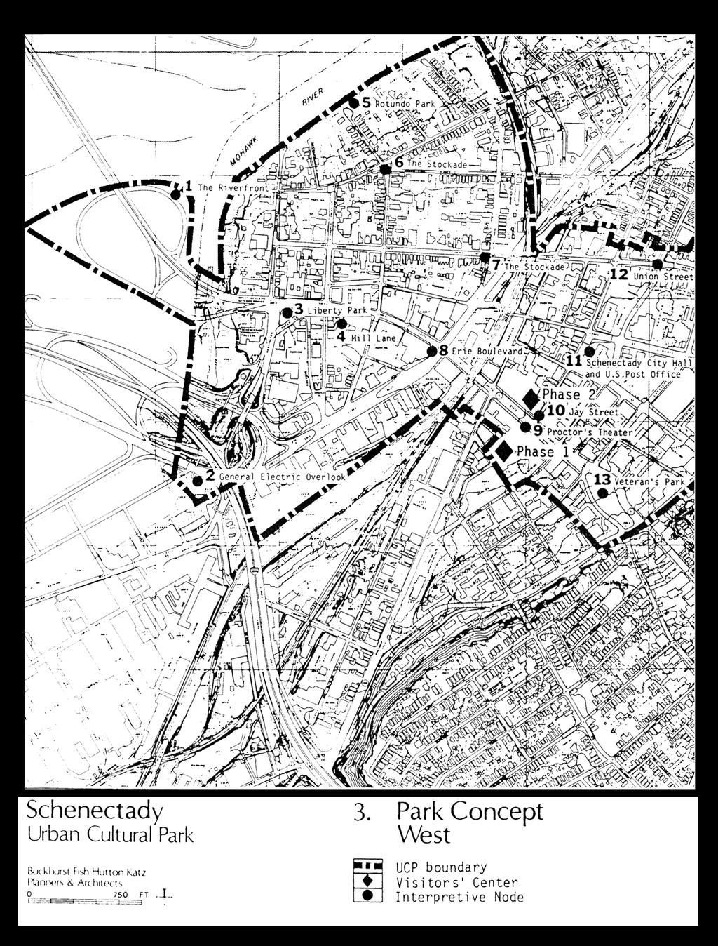
2 a flat-bottomed boat that was paddled, towed or poled by eight to ten men.. This in turn was succeeded by the Durham, also flat-bottomed and with more cargo space and sails. In addition to its role as commercial center, Schenectady was also a boat building center. By 1815 passenger boats, similar in style to the Durham, provided daily service on the Mohawk as well. Wharves, warehouses and shipbuilding concerns dominated the banks of the river until they were destroyed by fire in With the advent of the Erie Canal in 1823, the harbor was not needed and was never rebuilt. The site is adjacent to the Stockade, the oldest area of the City, which was founded in The Stockade has been placed on the National and State Registers of Historic Places. The Stockade has remained essentially residential since the time of the fire. Some buildings survived the fire and date from the early 1700s. Since many of the early settlers were of Dutch origin, homes in the Stockade reflect the Dutch influence with their high gables and narrow deep lots. Through preservation and restoration efforts of residents and owners, the Stockade exists today as an impressive example of urban revitalization. The Pump House site and Riverwalk, while not officially within National Register boundaries, is viewed as a part of the Stockade area. The pumping facility was originally built to pump water from the Mohawk River into the City water supply system. The original pump house on the site (Attachment 1) was built by the Schenectady Water Company in 1871 (year of completion). According to information provided in History of Schenectady County, N.Y to 1886 (New York: WW. Munsall & Co. 1886), the pumping system, known as the Holley system, involved pumping the water, piped from the river, from a large cistern or well built under the ground near the margin of the river. The stone walls of the well and a surrounding course of gravel and sand purified the water before entering the well. The present pump house, built about 1913, replaced the original structure. When the water supply was moved to a nearby well field, the pump station continued to serve the City, and now the Village of Scotia, as a sewage pump station. The facility is owned, operated and maintained by the City of Schenectady. The operation and maintenance of the pump house and site are funded under the City of Schenectady Sewer Fund. The adjacent parking lot and walkway are owned and maintained by the City of Schenectady. Today the riverfront area provides exceptional opportunities for recreational activities such as biking, walking, and picnicking. There is also potential for pleasure boat tie-ups nearby. The entire area,known as Riverside Park (it is sometimes referred to as Rotundo Park), comprises about 6 acres. This area runs more than 1/3 of a mile along the banks of the river, linking to Washington Avenue and Schenectady County Community College. This area is a component of the Schenectady Urban Cultural Park Management Plan, which includes among its Park Objectives to develop Mohawk Riverfront to its full potential as a recreational area. and also sets as a goal to utilize fully Schenectady s natural resources (please refer to Attachment 2). The Management Plan sets forth specific performance standards which include improvement to the appearance of parks in the Urban Cultural Park, to increase the number and location of overlooks developed, and to increase the number of persons visiting and using the riverfront area (Attachment 2). The site also relates directly to the Urban Cultural Park theme of Labor and Industry and subtheme of Transportation, with the historic commercial boat traffic mentioned above. (Attachment 3 shows the boundaries of the west area of the Urban Cultural Park with the project site within those boundaries.)
3 In addition the Riverwalk would provide a connection to the existing Mohawk-Hudson Bikway near the area where the bike trail heads west along the Erie Canal and a bikeway segment along city streets crosses the river and enters Collins Park in Scotia (Attachment 4). The schematic site plan for Pump House, Overlook and the Riverfront Walk is presented graphically in the attached drawing (Attachment 5). The components have been designed to encourage pedestrian use of the area. The Pump House itself will be refurbished by reconditioning the stucco, repointing the brick and masonry, restoring the limestone at the door surrounds, and repainting the structure in a period-appropriate color. The proposed work also includes rebuilding of concrete stairs and replacement of another set of concrete stairs, installation of a new cornice board, reglazing window panes, replacement of exterior doors with insulated doors, and resetting the existing copper roof edge. The chain link fence is replaced with a high ornamental steel fence. The existing parking lot is reconfigured, repaved, and curbed; landscaping screens and softens the area. A brick-paved walk lined with trees leads from the street to a gathering space by the river. The focal point is a cannon, which has been relocated on the site and is set on a paved, elevated area, facing the river. Beyond the cannon is a river overlook defined with an ornamental railing. A bosque of trees, benches, and pedestrian-scale lighting invite walkers and bikers to stop and view the river. Interpretive signage will display information about the industrial history of the river. Since this project qualifies as an Unlisted Action under State Department of Environmental Conservation regulations, a short Environmental Assessment Form has been completed and is included with this application. A Joint Application for Permit (DEC/USACOE) and a NYS Barge Canal Permit Application have been submitted to the appropriate agencies. Copies of these applications are enclosed. This project is proposed and supported by the City of Schenectady. The proposal involves only city-owned land; the site and the Pump House building are currently and will continue to be maintained by the City. The project has been brought to the schematic site plan stage. Upon notification of award of grant, the City is prepared to go into the final design and preparation of contract documents for bidding. The expect construction start date is April 15, The project has been endorsed by the State Senator Hugh T. Farley, Assemblyman Paul Tonko, Assemblyman James Tedisco, the Schenectady Heritage Area of the Schenectady Department of Development, the Mohawk Valley Heritage Corridor Commission, Schenectady Stockade Association, and by several residents of the Stockade area. The letters of endorsement are included with this application. H:\Landscape Architecture\2000 Projects\L Pump House River Front\OPRHP Grant Application\ApplicationNarrative wpd

4 ATTACHMENT 1 Former North Ferry Street Water Works from a photograph in the collection of the Schenectady County Historical Society (undated).
5 ATTACHMENT 2 From Schenectady Urban Cultural Park Management Plan, 1986, Table 3, Page 27. 3, Page 4
6
ROME WATERFRONT VILLAGE PROJECT NARRATIVE January 25, 2018
 January 25, 2018 The Rome Waterfront Village project is intended to foster the revitalization of the area between South James Street and Erie Boulevard north of the Erie Canal as well as improve public
Creation of Confluence Park and Input from Vermont River Conservancy
 CITY COUNCIL Agenda Item #18-236 Date: August 22, 2018 Consent Discussion X SUBJECT: Creation of Confluence Park and Input from Vermont River Conservancy SUBMITTING DEPARTMENT: Mayor RECOMMENDED ACTION:
PROJECT SITE The Proposed Project includes the Allen and Pike Street malls between Delancey and South Streets (see Figure 2C-1).
.") Chapter 2, Section C: A. INTRODUCTION This chapter considers the potential of the proposed Reconstruction of the Allen and Pike Street Malls project to affect the urban design characteristics and visual
Chapter 2, Section C: A. INTRODUCTION This chapter considers the potential of the proposed Reconstruction of the Allen and Pike Street Malls project to affect the urban design characteristics and visual
Please read the entire document
 projects impacting the waterfront revitalization area. The waterfront revitalization area of the town will have to subareas to the west and east of the village. Page 6 of 6 Wayfinding master plan create
TURN TO THE RIVER CITY PLAZA LANDSCAPE DESIGN CONCEPT May 25, 2016
 Turn to the River is a multi-year project of Art Spaces - Wabash Valley Outdoor Sculpture Collection, Inc. to connect downtown Terre Haute with the Wabash River through public art and design. The four-square
Spring 2018 Construction Update
 Spring 2018 Construction Update Ward 3 Southwest Engineering Department Locust Street Bridge over the Des Moines River The Locust Street Bridge over the Des Moines River project is being let through the
MIDTOWN MIXED-USE VILLAGE. TECHNICAL DATA SHEET COMPONENT C-1 FOR PUBLIC HEARING - PETITION NUMBER Project No RZ1.1. Issued.
 N MIDTOWN MIXED-USE VILLAGE TECHNICAL DATA SHEET COMPONENT C- FOR PUBLIC HEARING - PETITION NUMBER 04-00 Project No. 496 Issued Revised SCALE: " = 0' N 0 0 0 40 RZ. c GENERAL PROVISIONS: a. SITE LOCATION.
Town Center Design Guidelines
 Adopted by City Council on September 18, 2018 Design Theme The Draper Town Center Design Theme is defined as encompassing those architectural design styles that were prevalent in the construction of civic
12 Foot Davis and Adjacent Sites
 Peace River, Alberta Proposed Concept Design Presentation and Discussion January 26, 2010 Peace River Provincial Recreation Area 12 Foot Davis Grave Site Dr. Greene Cairn North Environments Landscape Architects
Copake Hamlet Plan: Visioning Workshop
 Copake Hamlet Plan: May 2-3 rd 2015 Hamlet Revitalization Task Force Jeffrey Nayer, Town Supervisor Jeanne Mettler, Town Board Chris Quinby Peggy Lewis Jennifer Redman Roberta Roll John Pollok Russ Davis
Preliminary Sketch Plan for Fort Hunter Park
 Preliminary Sketch Plan for Fort Hunter Park Public Presentation November 19, 2009 Dauphin County Parks and Recreation 100 Fort Hunter Road Harrisburg, PA 17110 (717) 599-5188 www.dauphinc.org THOMAS COMITTA
Contact Name: Jennifer Hoppa or Wilbert Woods, NYC DCP, Waterfront & Open Space Division
 BOROUGH: Manhattan MAP ID# C4 COUNCIL DISTRICTS: 1, 2, 3, 4, 5, 6, 7, 8, 9, 10 COMMUNITY BOARDS: 1, 2, 3, 4, 6, 7, 8, 9, 10, 11, 12 NAME OF PLAN: Comprehensive Manhattan Waterfront Plan Community Organization:
Plan for Restoration of the Cottage
 Retrospective Plan for Restoration of the Cottage 1936 Restoration The Van Zandt Cottage was first restored in 1936 by the Daughters of the Republic of Texas and the United Daughters of the Confederacy
ARTICLE IX SPECIAL PERMIT USES
 ARTICLE IX SPECIAL PERMIT USES All special permit uses cited in Article IX and Attachment A of this Ordinance or any other Section of this Ordinance shall be subject to Site Plan Review. The procedures
Reconnecting to a Forgotten River St. Cloud MN. Aaron Hanson Design Design Thesis LA 572, Thesis, Spring 2012
 Reconnecting to a Forgotten River St. Cloud MN Aaron Hanson Design Design Thesis LA 572, Thesis, Spring 2012 site context 2.5 Miles Sartell St. Cloud to Fargo 170 Miles (2 hrs 45 mins) Hwy 10 infrastructure
CITY OF VAUGHAN EXTRACT FROM COUNCIL MEETING MINUTES OF MAY 27, 2014
 CITY OF VAUGHAN EXTRACT FROM COUNCIL MEETING MINUTES OF MAY 27, 2014 Item 6, Report No. 21, of the Committee of the Whole, which was adopted without amendment by the Council of the City of Vaughan on May
CHAPTER 3 DOWNTOWN COMMERCIAL DISTRICT CHARACTER AREA
 CHAPTER 3 DOWNTOWN COMMERCIAL DISTRICT CHARACTER AREA 3.1 INTRODUCTION The Downtown Commercial District Character Area of Grass Valley comprises all of the city's core historic commercial district, including
PRELIMINARY REPORT. HIGHWAY 18 CORRIDOR NEIGHBORHOOD PLAN VILLAGE OF DOUSMAN November, 2014
 PRELIMINARY REPORT HIGHWAY 18 CORRIDOR NEIGHBORHOOD PLAN VILLAGE OF DOUSMAN November, 2014 This preliminary report presents the initial recommendations for land use within the Highway 18 corridor along
 PLANNING COMMISSION STAFF REPORT MEETING DATE: PROJECT NUMBER: ZONE: REQUEST: ADDRESS: APPLICANT: PREPARED BY: 6 July 2017 D-17-006 Commercial Corridorr Design Review Approval a parking lot expansion 26
HISTORIC PRESERVATION SERVICES Statement of Qualifications
 HISTORIC PRESERVATION SERVICES Statement of Qualifications Environmental Design & Research, Landscape Architecture, Engineering & Environmental Services, D.P.C. 217 Montgomery Street, Suite 1000 Syracuse,
City of Poughkeepsie Waterfront Redevelopment Strategy. Poughkeepsie Waterfront Redevelopment Strategy
 City of Poughkeepsie Waterfront Redevelopment Strategy Poughkeepsie Waterfront Redevelopment Strategy City of Poughkeepsie Prime Assets: Major Waterfront Advantages: - Central City of the Hudson River
DOWNTOWN FACADE GUIDELINES COMMUNITY DEVELOPMENT DEPARTMENT
 DOWNTOWN FACADE GUIDELINES COMMUNITY DEVELOPMENT DEPARTMENT DOWNTOWN FAÇADE DESIGN GUIDELINES The following design guidelines should be used by any owner of a building or an applicant of the Village s
TOWN OF BETHLEHEM MEETING SUMMARY LOCAL WATERFRONT REVITALIZATION PROGRAM UPDATE
 TOWN OF BETHLEHEM LOCAL WATERFRONT REVITALIZATION PROGRAM UPDATE MEETING SUMMARY Purpose: LWRP Update Public Workshop #3 Date and Time: October 24, 2017, 6:00 pm - 8:00 pm Location: Town Hall, 445 Delaware
DRAFT. Waterfronts and Open Spaces. 10 The Riverfront Open Space System
 CHAPTER 4 Waterfronts and Open Spaces 10 The Riverfront Open Space System 12 Planned, proposed and envisioned riverfront recommendations. Figure 4.3.23 The riverfront will become a major new public amenity
Illustration of Eastlake Farmer s Cooperative Grain Elevator. Chapter 5: implementation 5-1
 Illustration of Eastlake Farmer s Cooperative Grain Elevator Chapter 5: implementation 5-1 chapter 5: implementation Introduction The Eastlake Subarea Plan includes a wide range of recommendations intended
BRADENTON RIVERWALK EXPANSION MASTER PLAN
 BRADENTON RIVERWALK EXPANSION MASTER PLAN INTRODUCTION & AGENDA Process Update Community Engagement Summary Center for Active Design (CfAD) Recommendations Context and Existing Conditions Master Plan Alternatives
Saranac River Trail Greenway C O N D I T I O N S R E P O R T
 Saranac River Trail Greenway C O N D I T I O N S R E P O R T City of Plattsburgh Clinton County, NY For: Clinton County Final Issued: March 22, 2017 This document was prepared for the New York State Department
PRINCE EDWARD COUNTY HIGHWAY CORRIDOR OVERLAY DISTRICT DESIGN GUIDE
 PRINCE EDWARD COUNTY HIGHWAY CORRIDOR OVERLAY DISTRICT DESIGN GUIDE AUGUST 21, 2012 Table of Contents Introduction 3 Sample Architecture 4 Design Standards Access and Circulation 6 Buildings 7 Landscaping
PUBLIC SPACE/AMENITY PROJECTS
 BUFFALO S LWRP 49 A1. Black Rock Canal Park Improvements Erie County Parks Black Rock Canal Park, Ontario and Niagara Street intersection PROJECT DESCRIPTION: Erie County s Black Rock Canal Park is 4.25
Mendota Heights 2040 Comprehensive Plan Draft Vers
 4 Parks and Trails The City of Mendota Heights boasts a variety of recreational and open space opportunities. Few cities can claim access to regional trails, riverside and lakeside parks, scenic bluffs
Chapter 2, Section C: Urban Design and Visual Resources A. INTRODUCTION
 Chapter 2, Section C: Urban Design and Visual Resources A. INTRODUCTION This attachment considers the potential of the proposed East River Waterfront Access Project at Peck Slip to effect urban design
FAÇADE DESIGN GUIDE. A Placemaking Initiative of the City of Richmond Department of Planning & Development Review
 FAÇADE DESIGN GUIDE A Placemaking Initiative of the City of Richmond Department of Planning & Development Review December 2013 arts DISTRICT Facade Improvement Target Area N Belvidere W Broad Brook Leigh
Design Guidelines for the Route 30 Corridor Master Plan: Subdivision and Land Development Elements
 Design Guidelines for the Route 30 Corridor Master Plan: Subdivision and Land Development Elements East Whiteland Township- Chester County, PA Prepared by: Draft: May 7, 2018 Design Guidelines for the
Anatomy of A Vibrant Downtown. Anatomy of a Vibrant Downtown
 Anatomy of A Vibrant Downtown The goal of MAIN ST. REVITALIZATION PLANNING is to provide a framework that will help transform your downtown into a VIBRANT DOWNTOWN a place where people love to LIVE, WORK,
REZONING APPLICATION MPD SUPPLEMENT
 REZONING APPLICATION MPD SUPPLEMENT For Staff Use Only: DATE/TIMESTAMP: ZA# RECEIVED BY: The intent of the Master Planned District (MPD) designation is to allow flexibility in the design and construction
Historic Ottawa Beach Waterfront Walkway Park Township
 Historic Ottawa Beach Waterfront Walkway Park Township Project Description: Public access improvements to the shoreline of Lake Macatawa are the final steps in completing the park master plan for the Historic
PIQUA OHIO PLACEMAKING INITIATIVE
 PIQUA OHIO PLACEMAKING INITIATIVE A HANDBOOK to understanding the Placemaking Initiative for Piqua, Ohio June 15 2016 GAMBLE ASSOCIATES urban design BOOKER DESIGN COLLABORATIVE landscape architecture CITYVISIONS
West Dennis Center: Bass River to Old Main Street. West Dennis Business District: Old Main Street to Dennis Commons
 West Dennis Center: Bass River to Old Main Street West Dennis Business District: Old Main Street to Dennis Commons Dennisport Center: Dennis Commons to Division Street Main Street Project Goals Project
1. PLANNING CONCEPTS. Central Petaluma Specific Plan Chapter 1. Planning Concepts Page 7
 Page 7 1. PLANNING CONCEPTS Overview of Planning Concepts The plan for Central Petaluma envisions a reinvigorated central district that accommodates a greater diversity and intensity of activities, including
A cknovvledgements. Table of Contents. Project Introduction...1
 Pashek Asscx::iates MARCH2007 A cknovvledgements Pashek Associates would like to thank Jackson Township and the Jackson Township Recreation Board for their valuable contributions, support, and input during
Jewel. Platte. of the. Plattsmouth Main Street Landscape Architecture by HDR
 Jewel of the Platte Plattsmouth Main Street Landscape Architecture by HDR Plattsmouth, Nebraska is a historic community of 6,500 residents located along the west bank of the Missouri River, just south
REQUEST FOR PROPOSALS
 REQUEST FOR PROPOSALS To develop a signage master plan for the Bronx River Greenway and Blueway. Table of Contents Section I - Timetable Section II Summary of the RFP Section III Scope of Work Section
Project Consulting Team:
 THE DOWNTOWN CHERRYVILLE LAND USE + STREETSCAPE MASTER PLAN WAS FUNDED THROUGH THE GENEROUS DONATIONS OF THE FOLLOWING: The Community Foundation of Gaston County ElectriCities of North Carolina The Cherryville
5.2 LAND USE AND ZONING
 5.2 LAND USE AND ZONING This section describes the land use and zoning of the project site and surrounding area, followed by an analysis of the potential for incompatibility or adverse impact on prevailing
Washington Pass Overlook
 Washington Pass Overlook The Washington Pass Overlook is located on the Methow Valley Ranger District on the Okanogan-Wenatchee National Forest. The overlook is at the crest of Washington Pass and is part
COMMUNITY DEVELOPMENT DEPARTMENT
 COMMUNITY DEVELOPMENT DEPARTMENT CONDITIONAL USE APPLICATION FOR CITY USE ONLY Date Received: Date Determined Complete: Fees Paid: PC Meeting: Fees: $200 / $400 with Site Plan; plus all applicable Engineering
B L A C K D I A M O N D D E S I G N G U I D E L I N E S for Multi-family Development
 B L A C K D I A M O N D D E S I G N G U I D E L I N E S for Multi-family Development Adopted June 18, 2009 This section of the Design and focuses on site planning and design guidance for new multi-family
Matton Shipyard Preservation & Adaptive Reuse Planning & Feasibility Study
 Matton Shipyard Preservation & Adaptive Reuse Planning & Feasibility Study Erie Canalway National Heritage Corridor March 16, 2018 Site History The Matton Shipyard was a boat building and marine towing
VILLAGE OF CHANNAHON COMMERCIAL DESIGN GUIDELINES. Village of Channahon S. Navajo Drive Channahon, IL (815)
") VILLAGE OF CHANNAHON COMMERCIAL DESIGN GUIDELINES Village of Channahon 24555 S. Navajo Drive Channahon, IL 60410 (815) 467-6644 www.channahon.org Adopted March 6, 2006 VILLAGE OF CHANNAHON COMMERCIAL DESIGN
VILLAGE OF CHANNAHON COMMERCIAL DESIGN GUIDELINES Village of Channahon 24555 S. Navajo Drive Channahon, IL 60410 (815) 467-6644 www.channahon.org Adopted March 6, 2006 VILLAGE OF CHANNAHON COMMERCIAL DESIGN
Rezoning Transportation Analysis Petition Number: General Location Identifier:
 From: Kelsie Anderson, PE Kelsie.Anderson@charlottenc.gov 704-432-5492 Staff Reviewer: Kory Hedrick, PE, PMP Khedrick@charlottenc.gov 704-432-6511 CDOT s review of this rezoning petition is intended to
FREEWAY/TOURIST DISTRICT
 FREEWAY/TOURIST DISTRICT DESIGN STANDARDS FOR THE CITY OF MOUNTLAKE TERRACE March, 2014 MOUNTLAKE TERRACE FREEWAY/TOURIST DESIGN STANDARDS March, 2014 1 TABLE OF CONTENTS Introduction...1 Design Site Design
CITY HISTORIC ZONING COMMISSION STAFF REPORT - CERTIFICATE OF APPROPRIATENESS APPLICATION
 CITY HISTORIC ZONING COMMISSION STAFF REPORT - CERTIFICATE OF APPROPRIATENESS APPLICATION MEETING DATE: 9/19/2013 FILE NO.: 070113MKT APPLICANT: Brett Honeycutt 3G Studios (architect) ADDRESS OF PROPERTY:
Construction and Landscaping on Public Property
 Construction and Landscaping on Public Property City of Manhattan Beach Community Development Department 1400 Highland Avenue 310-802-5504 www.citymb.info January, 2004 Construction and Landscaping on
Our Legacy Projects DOWNTOWN JACKSONVILLE MASTER PLAN
 DOWNTOWN JACKSONVILLE MASTER PLAN A major component of our master plan is the creation of a strong and accessible open space and recreation system. The four most vital links in that system are our legacy
Rundel Library Elevated River Terrace Reconstruction City of Rochester, N.Y. Application Number July 2017
 Rundel Library Elevated River Terrace Reconstruction City of Rochester, N.Y. Application Number 75047 July 2017 PROJECT DESCRIPTION The Rundel Library is a nationally registered historic building surrounded
CHAPTER 2: HISTORIC BACKGROUND
 CHAPTER 2: HISTORIC BACKGROUND The historic town of Eastlake was created on June 22, 1911 when the Eastlake Subdivision was recorded at the Adams County Clerk and Recorder s Office. The Eastlake Investment
Town of Yucca Valley Capital Improvement Projects Report July 24, 2014
 Town of Yucca Valley Capital Improvement Projects Report July 24, 2014 SR 62 Traffic and Pedestrian Improvements from Apache Trail to Palm Avenue (PLHD) The project includes construction of curbs, gutters,
Blue Line LRT Extension
 v e Noble Pkwy Noble Pkwy Xerxes Ave N Shingle Creek Penn Ave N Penn Ave N Fremont Ave N Lyndale Ave N S Washington Ave University Ave NE Blue Line LRT Extension LIGHT RAIL PLATFORM AND STATION DESIGN
The Vision. Photo provided by The Minervini Group. 46 Vision, Objectives & Strategies
 Vision, Objectives & Strategies The is the public framework and guide for future development of the Grand Traverse Commons. The establishes public polices for infrastructure, the preservation of natural
L 4-1. Heritage Report: Reasons for Heritage Designation. Kodors House. 35 Rosedale Avenue West
 L 4-1 Brampton Heritage Board Date: January 17, 2012 Heritage Report: Reasons for Heritage Designation Kodors House 35 Rosedale Avenue West December 2011 1 L 4-2 Profile of Subject Property Municipal Address
Rezoning Petition Pre-Hearing Staff Analysis April 16, 2018
 Rezoning Petition 2017-177 Pre-Hearing Staff Analysis April 16, 2018 REQUEST LOCATION Current Zoning: O-2 (office) and MUDD-O (mixed use development, optional) Proposed Zoning: MUDD-O (mixed use development,
NORTH COLLEGE PARK. Residential Neighborhood and Neighborhood Center OBJECTIVES EXISTING SITUATION AND ISSUES CONCEPT
 Greenbelt Metro Area Sector Plan - Subarea Design Policies and Guidelines - North College Park 119 NORTH COLLEGE PARK Residential Neighborhood and Neighborhood Center CONCEPT North College Park is envisioned
Main Street Conversion Site
 Main Street Conversion Site Borough of Brooklyn, New York Preliminary Presentation Park Expansion Design & Development Committee 13 September 2012 Michael Van Valkenburgh Associates, Inc. Landscape Architects,
Mableton Parkway & Veterans Memorial Highway Design Guidelines
 Mableton Parkway & Veterans Memorial Highway Design Guidelines Background and Purpose Mableton Parkway and Veterans Memorial Highway are key corridors in the Mableton community. Both are critically important
A. INTRODUCTION B. DESCRIPTION OF PROPOSED PROJECT
 Chapter 1: Project Description A. ITRODUCTIO The City of ew York (the City ) Department of Parks and Recreation (DPR) has requested funds from the Lower Manhattan Development Corporation (LMDC) for improvements
CHAPTER 6 DESIGN GUIDELINES FOR INDIVIDUAL BUILDING ELEMENTS. Commercial Facades
 Design Guidelines for Historic Resources CHAPTER 6 DESIGN GUIDELINES FOR INDIVIDUAL BUILDING ELEMENTS This chapter presents design guidelines for the preservation of individual historic building elements
VEHICULAR AND PEDESTRIAN CIRCULATION
 This perspective sketch communicates the intended character and quality of a proposed streetscape design. Locate benches near a major intersection where people tend to gather. Seating and lighting provide
BURTON STATION STRATEGIC GROWTH AREA PLAN UPDATE PUBLIC MEETING 3/26/18
 BURTON STATION STRATEGIC GROWTH AREA PLAN UPDATE PUBLIC MEETING 3/26/18 1 WHERE WE ARE? 2 PRIMARY OBJECTIVES OF THE PLAN UPDATE 1. Update the land use designation for Burton Station Village to reflect
Overview Report. Proposed Development
 Overview Report Proposed Development the construction of a 1km cycle/pedestrian trail including a new footbridge, new car park and entrance road at Drumshanbo Lock and a new pedestrian/cycle road crossing,
Grand River Ravines Georgetown Township
 Grand River Ravines Georgetown Township Project Description: The Grand River Ravines County Park property is composed of the 68-acre former Fillmore at the Bend Open Space purchased in 1999 and two more
Potential Green Infrastructure Strategies May 6, 2015 Workshop
 Potential Green Infrastructure Strategies May 6, 2015 Workshop Background The City of Cortland is developing the Tioughnioga Urban Headwaters Green Infrastructure Action Plan with funding from the National
Name of Action: Arrangement of beach locations on the River Vikhra
 COMUS PROJECT PILOT TOWN: MSCISLAŬ REFERENCE PLAN ACTION N 3.1 Name of Action: Arrangement of beach locations on the River Vikhra Location Image Summary: To develop recreation sites on the beaches of the
2010 Tentative Enhancement Program Allocations (FY11)
") Bristol 10011 Buchanan County Buchanan County project cost $1,190,332 Bull Creek Trail - construction of a pedestrian/bicycle trail along abandoned request amount $240,323 railroad right of way. allocation
Bristol 10011 Buchanan County Buchanan County project cost $1,190,332 Bull Creek Trail - construction of a pedestrian/bicycle trail along abandoned request amount $240,323 railroad right of way. allocation
Monday, October 5, THE LIGHTHOUSE, PIER 61 at CHELSEA PIERS, HUDSON RIVER PARK, NEW YORK CITY SPONSORSHIP DECK
 Monday, October 5, 2015 THE LIGHTHOUSE, PIER 61 at CHELSEA PIERS, HUDSON RIVER PARK, NEW YORK CITY SPONSORSHIP DECK ABOUT US Our Mission The Waterfront Alliance works to protect, transform, and revitalize
The open space system should provide connective elements, relate to natural resources, and enhance the suburban character of the landscape..
 The open space system should provide connective elements, relate to natural resources, and enhance the suburban character of the landscape.. Mixed-use and infill development should maintain or enhance
New Park / Entry Court & Plaza Concept Design
 New Park / Entry Court & Plaza Concept Design The SECC Public realm is proposed to have a focus on health, wellness, and community and that site users will include patrons of the neighbourhood. The block
Land at Three Elms, Hereford PRE-SUBMISSION EXHIBITION June 2016
 Design Principles Emanating from the key themes from the Community Planning Weekend and technical assessment conducted, a series of design principles were developed.these principles were presented during
Analysis of Environs of 1000 New York Street, German Methodist Episcopal Church
 Item No. 3: L-14-00028 p.1 Analysis of Environs of New York Street, German Methodist Episcopal Church Step One Historical Significance and Context According to the application for Historic Landmark Designation,
AMSTERDAM S PARK OVER THE RIVER HOW THE MOHAWK VALLEY GATEWAY OVERLOOK RECONNECTED A CITY
 AMSTERDAM S PARK OVER THE RIVER HOW THE MOHAWK VALLEY GATEWAY OVERLOOK RECONNECTED A CITY Presentation Overview Background Design Process and Goals Concepts Design Development Public Participation Process
GUIDELINES WESTON LOCATION: URBAN DESIGN GUIDELINES
 Development in the Weston area will be consistent with the following urban design guidelines. The guidelines correspond to Site and Area Specific Policies 45, 46, 47, 48, 49, 51, 52 and 232 in Chapter
TOWN CENTER DESIGN STANDARDS FOR THE CITY OF. August, MOUNTLAKE TERRACE TOWN CENTER DESIGN STANDARDS August,
 TOWN CENTER DESIGN STANDARDS FOR THE CITY OF MOUNTLAKE TERRACE August, 2008 MOUNTLAKE TERRACE TOWN CENTER DESIGN STANDARDS August, 2008 1 TABLE OF CONTENTS Introduction...3 Design Site Design...4 Pedestrian
CITY HISTORIC ZONING COMMISSION STAFF REPORT - CERTIFICATE OF APPROPRIATENESS APPLICATION
 CITY HISTORIC ZONING COMMISSION STAFF REPORT - CERTIFICATE OF APPROPRIATENESS APPLICATION MEETING DATE: 8/15/2013 FILE NO.: 070113MKT APPLICANT: Brett Honeycutt 3G Studios (architect) ADDRESS OF PROPERTY:
City of Plattsburgh DRI: Downtown Streetscapes & Riverfront Access. Downtown Streetscape and Riverfront Access Design
 City of Plattsburgh DRI: Downtown Streetscapes & Riverfront Access Welcome Thank you for coming this evening. Agenda PART I - Project Context The Downtown Revitalization Program Our DRI Projects Other
GLEN ELLYN APPEARANCE REVIEW GUIDELINES
 GLEN ELLYN APPEARANCE REVIEW GUIDELINES PHOTO RESOURCE DIRECTORY August 8, 2007 Village of Glen Ellyn Planning and Development Department 535 Duane Street Glen Ellyn, IL 60137 (630) 547-5250 www.glenellyn.org
FOR SALE OR LEASE ±12,600 SQ. FT. AUTO/TRUCK SERVICE FACILITY
 FOR SALE OR LEASE ±12,600 SQ. FT. AUTO/TRUCK SERVICE FACILITY FOR ADDITIONAL INFORMATION, CONTACT 2 TAYLOR AVENUE CITY OF POUGHKEEPSIE, NY James Martin Senior Vice President Exclusive Broker BUILDING:
Rights-of-Way Preservation Guidelines
 Rights-of-Way Preservation Guidelines Summary of Policy The purpose of the Rights-of-Way Preservation Guidelines is to help staff make decisions about preserving rights-ofway for future transportation
3.13. Development Guidelines
 3.3 Landscaping Elements Landscaping should be used to frame and soften structures, define site functions, enhance the quality of the environment, and screen undesirable views. Safety, environmental impacts,
DRAFT ROOSEVELT ROAD. District Recommendations. Figure 5.23 The Roosevelt Road Corridor
 CHAPTER 5 Figure 5.23 The Road Corridor Road will develop as a mixed-use corridor, emphasizing regional retail, west of the river and mixed-use development east of the river. KEY RECOMMENDATIONS 1. High
7-PARKS, OPEN SPACE & PUBLIC ART
 7-s, Open Space & Public Art 7-PARKS, OPEN SPACE & PUBLIC ART This chapter provides recommendations for the expansion of new parks, plazas and open space that serve the many user groups targeted for downtown.
ACADEMY AREA CONCEPT PLAN
 ACADEMY AREA Strip ling C hape l Roa d CONCEPT PLAN 7 S2 U Stripling 52 ROADWAYS AND PARKING: ADVENTURE PLAYGROUND AND SPRAYGROUND: Current roadways follow existing drives. It is recommended that the Folds
Port of Camas-Washougal Waterfront Trail Master Plan
 Port of Camas-Washougal Waterfront Trail Master Plan The Port s facilities are the products of its mission: To make strategic investments that enhance the community s quality of life by bringing jobs,
Project Goal. RRRC Living Towns Planning Workshp. Town of Halifax Revitalization Project. Dynamic Planning & Management Duo: July 12, 2006
 Project Goal Town of Halifax Revitalization Project RRRC Living Towns Planning Workshp July 12, 2006 Town of Halifax Halifax County *** Revitalization Project Goal*** To create Economic Opportunity and
TORTI GALLAS and partners, inc. How to Retrofit Your Suburb to Make a Downtown
 How to Retrofit Your Suburb to Make a Downtown April, 2010 Where to Start What should the Town look like? How do I attract new residents, businesses and visitors?? Should we preserve our heritage? How
City of Niagara Falls. New York. D Amelio Park Playground
 New York January 2018 Consultation and Review Form Type of Review Required: X Mandatory Consultation Project Registration Number Voluntary Review and/or Endorsement PROJECT SPONSOR INFORMATION Name: City
KEY MAP DEVELOPMENT PERMIT AREA MAP. Sunnymede North Sub-Area Plan
 Richmond Official Community Plan BROADMOOR AREA SUNNYMEDE NORTH SUB-AREA PLAN Bylaw 7100 Schedule 2.6C SUNNYMEDE NORTH SUB-AREA PLAN SUNNYMEDE NORTH SUB-AREA PLAN SUNNYMEDE NORTH SUB-AREA PLAN KEY MAP
Barnstaple's new riverside quarter
 Artist's impression of completed site Welcome to our exhibition of plans for new homes and commercial phases 2a and 2b of Anchorwood Bank. Anchorwood Bank is the most important development site in Barnstaple.
Corridor Enhancements
 Corridor Enhancements Safety is MoDOT s first priority in widening and rebuilding I-70 across the state of Missouri. MoDOT also understands that the interstate - and its interchanges and overpasses - are
MINNESOTA ARCHITECTURE - HISTORY INVENTORY FORM
 Identification Historic Name Dean Parkway Bridge Current Name Bridge 90661 Field # Address Midtown Greenway over Dean Parkway City/Twp Minneapolis County Hennepin Legal Desc. Twp 29N Range 24W Sec 32 QQ
Johnson Street Bridge Public Realm Update
 Johnson Street Bridge Public Realm Update August 20, 2015 Background Johnson Street Bridge Replacement Project impacts a diverse range of stakeholders In addition to a new bridge, the project also includes
F. Driveways. Driveways which provide access to off-street parking or loading from public streets shall comply with the following:
 Section 20.945.040 General Design Standards for Surface Parking Areas. A. Review Authority. Parking lot design and drainage shall be subject to review and approval of the City Transportation Manager. B.