Northwest Corridor LRT Line to Irving/DFW Public Meeting No. 1 Project Overview
|
|
|
- Gervase Gardner
- 5 years ago
- Views:
Transcription
1 LRT Line to Irving/DFW Public Meeting No. 1 Project Overview January 21, 2004
2 Agenda Purpose Corridor Background Environmental Impact Assessment Public Involvement Plan Project Schedule
3 Purpose Project Status Receive Feedback* Alignment Station Locations Suggestions/Questions/Concerns (*Oral Comments, Comment Cards)
4 Corridor History 1983: NW Corridor in DART Final Service Plan 1989: DART Transit System Plan (TSP) includes rail to North Irving 1995: DART TSP-Rail To N. Irving TC 2000: NW Major Investment Study (MIS) Locally Preferred LRT Alternative 2000: TSP Revised to MIS Alternative 2002: DFW Rail Access Study 3 LRT Alternatives

5 NW to Irving/ DFW DART s 1983 Service Plan

6 NW to Irving/DFW DART s 1989 Transit System Plan

7 NW to Irving/DFW DART s 1995 Transit System Plan
8 Major Investment Study (MIS) Locally Preferred Investment Strategy Rail, Highway/HOV, TSM/CMS Components Adopted by DART Board February 22, 2000 (Res. No ) Supported by Irving City Council Resolution No
9 MIS LRT Rail Components: NW Corridor to Farmers Branch and Carrollton NW Corridor

10 NW to Irving/DFW DART s Current Transit System Plan
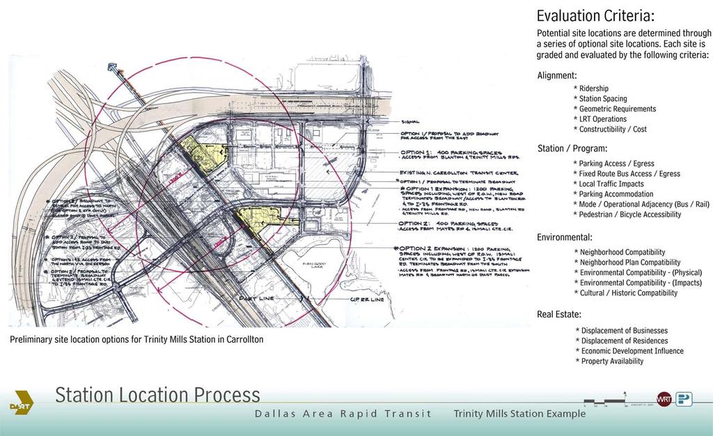
11 Corridor Developments MIS Alignment Conflicts SH 161 Future Expansion of SH 114 New Development Along SH 114 Future Airport Expansion Results Limited Right-of-Way, Limited Station Sites, Station Access Issues, Additional Aerial Structure, Several Highway Crossings, Significant Relocations and Displacements, Potential Highway Realignment MIS Alignment may no longer be a cost affordable, viable alternative

12 NW to Irving/DFW

13 NW to Irving/DFW DFW Access Study Rail Planning and Implementation MIS December 18, LRT Alternatives (Red)
14 Alignment Opportunities Direct Access to DFW Terminals 3 Airport Access Alternatives provide new areas for alignment consideration Serve Additional Irving Activity Centers (Verizon, North Lake College, Residential) Transit Oriented/Economic Development Potential
15 Environmental Impact Assessment Process Alignment Refinement Station Location Conceptual Engineering Environmental Analysis
16 Alignment Refinement Corridor does not have existing Railroad Right-of-Way Options include: Street Right-of-Way Highway Right-of-Way Utility Right-of-Way Airport Property Property Acquisition

17 NW Alternative Alignments
18 Station Location Process Typically 1 to 1.5 miles apart Serve major activity center Serve major transportation node
19 Station Considerations Parking Requirements Parking? No Parking? How much Parking? Access Automobile Bus Pedestrian At-Grade Stations preferred

20 DART Typical At-Grade Platform

21 DART Typical Aerial Platform
22 NW
23 Conceptual Engineering Determines the exact location of the alignment Where on the map On, Under or Above the ground Components Include: Horizontal Alignment Vertical Alignment Right-of-Way Plans Utilities Bridge Structures Drainage Station Design
24 Environmental Impact Assessment and Mitigation Monitoring Policy DART shall adopt a consistent approach in assessing environmental impact for the development of all transit facilities DART shall conform with all applicable federal, state, and local laws, ordinances, rules and regulations
25 Local Environmental Assessment (EA) Effort will be Equivalent to Environmental Impact Statement (EIS) Public & Agency Involvement Conceptual Engineering Station Planning/Design Environmental Documentation Operations Planning Ridership Analysis Final Document Mitigation Monitoring

26 Environmental Assessment Components Land Use Air Quality Noise/Vibration Visual/Aesthetic Resources

27 Environmental Assessment Components Wetlands Aquatic Habitat Wildlife Hydrology/Water Quality

28 Hazardous Material Construction Impact Cultural Resources Parklands Environmental Justice Environmental Assessment Components
29 Public Involvement Continuous Public Meetings Committee Meetings Briefings with Elected Officials Special Briefings (Home Owners Assoc., Civic Groups, Businesses and Business Groups Newsletters Web Site

30 NW Project Schedule
31 NW Contacts Carlos Huerta Community Representative DART Community Affairs 1401 Pacific Avenue PO Box Dallas, Texas Phone: 214/ Fax: 214/ John Hoppie Project Manager DART Planning 1401 Pacific Avenue PO Box Dallas, Texas Phone: 214/ Fax: 214/
Northwest Corridor LRT Line to Irving/DFW. Mandalay Place HOA February 7, 2005
 Northwest Corridor LRT Line to Irving/DFW Mandalay Place HOA February 7, 2005 Agenda: Introductions North Lake College Station Issues from November Meeting Recommendations Q & A Proposed Grade Separation
SOUTHWEST CORRIDOR EXTENSION. Environmental Evaluation and Basic Engineering Results PUBLIC MEETING/OPEN HOUSE November 18, 2009
 SOUTHWEST CORRIDOR EXTENSION Environmental Evaluation and Basic Engineering Results PUBLIC MEETING/OPEN HOUSE November 18, 2009 AGENDA I. Welcome/Introductions II. Project Review and Status III. Environmental
Atlanta BeltLine Corridor Environmental Study. Scoping Meeting August 2008
 Atlanta BeltLine Corridor Environmental Study Scoping Meeting August 2008 What Will We Be Discussing Today? Study Overview - How Did We Get Here? - What Is the Study About? - Who Is Involved? - Where Is
RESOLUTION NO. R Refining the route, profile and stations for the Downtown Redmond Link Extension
 RESOLUTION NO. R2018-32 Refining the route, profile and stations for the Downtown Redmond Link Extension MEETING: DATE: TYPE OF ACTION: STAFF CONTACT: Capital Committee Board PROPOSED ACTION 09/13/2018
Southeast Extension to RidgeGate Parkway Scoping Booklet
 Southeast Extension to RidgeGate Parkway Scoping Booklet PUBLIC SCOPING MEETING SCHEDULE Public Scoping Meeting Wednesday, November 2, 2011 6:00pm to 7:30pm City of Lone Tree Recreation Center Willow Room
Cotton Belt Regional Rail Corridor Project
 Cotton Belt Regional Rail Corridor Project North Dallas AFG University of Texas at Dallas Administration Building March 1, 2018 0 Discussion Public Involvement Project Scope Alignment Stations Environmental
Welcome. Northern Segment of Hwy 100 I-90 to South of Madison Street Meeting Goals:
 Welcome Northern Segment of Hwy 100 I-90 to South of Madison Street Meeting Goals: - Review Environmental Assessment - Share Preferred Alternative -Receive Public Comments 2003 EA Preferred Alternative
D2 Subway Project Development. Interagency Meeting July 27, 2018
 D2 Subway Project Development Interagency Meeting July 27, 2018 1 Agenda Welcome and Introductions Project Background D2 Project Overview Project Development (PD) Efforts Preliminary Engineering (PE) Environmental
Cotton Belt Corridor. Area Focus Group (AFG) Richardson/Plano August 24, John Hoppie, Capital Planning
 Richardson/Plano August 24, John Hoppie, Capital Planning") Cotton Belt Corridor Area Focus Group (AFG) Richardson/Plano August 24, 2017 John Hoppie, Capital Planning 0 Agenda Design Update Environmental Update Documentation of Existing Conditions Noise Traffic
Cotton Belt Corridor Area Focus Group (AFG) Richardson/Plano August 24, 2017 John Hoppie, Capital Planning 0 Agenda Design Update Environmental Update Documentation of Existing Conditions Noise Traffic
BeltLine Corridor Environmental Study
 BeltLine Corridor Environmental Study Joint TAC and SAC Meeting December 8, 2008 What We Will Discuss Today Outreach and Agency Coordination Scoping Results Existing Conditions Historical and Archeological
Gary & Regional Investment Project. October 27, Creating Tomorrow Today Comprehensive Regional Plan - NIRPC
 Creating Tomorrow Today 2040 Comprehensive Regional Plan Gary & Regional Investment Project October 27, 2010 Creating Tomorrow Today - 2040 Comprehensive Regional Plan - NIRPC What is NIRPC? - Northwestern
South Dakota 100 Corridor Preservation
 South Dakota 100 Corridor Preservation Purpose of this Public Hearing Inform Receive Input SD100 Project Progress East Side Corridor 1993 East Side Corridor EA March 20, 2003 SD100 Corridor Preservation
D2 Subway Project Development. Public Meeting September 12, 2018
 D2 Subway Project Development Public Meeting September 12, 2018 1 Agenda Project Background Process, Funding and Schedule Project Development (PD) Efforts Preliminary Engineering (PE) Environmental Impact
Gold Line Bus Rapid Transit Transit Oriented Development (BRTOD) Helmo Station Area Plan
 Helmo Station Area Plan") Appendix F Gold Line Bus Rapid Transit Transit Oriented Development (BRTOD) Helmo Station Area Plan Introduction and Purpose of the Plan The Gold Line Bus Rapid Transit facility is an eleven-mile dedicated
Appendix F Gold Line Bus Rapid Transit Transit Oriented Development (BRTOD) Helmo Station Area Plan Introduction and Purpose of the Plan The Gold Line Bus Rapid Transit facility is an eleven-mile dedicated
Welcome. to the 95th Street Terminal Improvement Project Public Hearing
 Welcome to the 95th Street Terminal Improvement Project Public Hearing The purpose of this Public Hearing is to solicit comments from the community about the Environmental Assessment prepared for the 95th
SOUTHEAST CORRIDOR EXTENSION. PUBLIC SCOPING MEETING/OPEN HOUSE October 15, 2008
 SOUTHEAST CORRIDOR EXTENSION PUBLIC SCOPING MEETING/OPEN HOUSE October 15, 2008 PROJECT BACKGROUND Project Overview Southeast Light Rail opened 2006 Southeast Corridor/Lone Tree Light Rail Extension Limited
Honorable Members of the Mobility Solutions, Infrastructure and Sustainability Committee
 Memorandum DATE January 23, 2019 CITY OF DALLAS TO Honorable Members of the Mobility Solutions, Infrastructure and Sustainability Committee SUBJECT I-30 East Project Update On Monday, January 28, 2019,
Kankakee River Bridge & Track Improvements Supplemental Environmental Assessment. May 5, 2016
 Kankakee River Bridge & Track Improvements Supplemental Environmental Assessment May 5, 2016 1 History: Chicago-St. Louis Corridor Since 1980 s IDOT has been looking at this corridor for high-speed service
Boca Raton II Tri-Rail Station PD&E Study and 30% Documents Public Kick-Off Meeting. August 29, 2017 Spanish River Library
 Boca Raton II Tri-Rail Station PD&E Study and 30% Documents Public Kick-Off Meeting August 29, 2017 Spanish River Library Introductions 2 Partner Stakeholder Agencies FDOT District Four Palm Beach Metropolitan
Declarations of Pecuniary Interest under the Municipal Conflict Of Interest Act
 Regional Municipality of Waterloo Heritage Planning Advisory Committee Minutes February 8, 2018 5:00 PM Regional Administrative Headquarters, Room 110 150 Frederick Street, Kitchener Present were: Councilor
DRAFT MAP AMENDMENT FLU 04-4
 DRAFT MAP AMENDMENT FLU 04-4 SW 24 TH AVENUE ROADWAY CORRIDOR The University of Florida participates with the Metropolitan Transportation Planning Organization (MTPO) in its responsibilities for the continuing,
7.0 PUBLIC AND AGENCY INVOLVEMENT
 7.0 PUBLIC AND AGENCY INVOLVEMENT This chapter documents the dialogue between DART and interested citizens and agencies regarding issues raised by the design and construction of the proposed project. This
Ashland BRT Environmental Assessment: logos of CTA, CDOT, Chicago Department of Housing and Economic Development
 Ashland BRT Environmental Assessment: logos of CTA, CDOT, Chicago Department of Housing and Economic Development Overview The Chicago Transit Authority (CTA), in partnership with the Chicago Department
APPENDIX I PUBLIC MEETING AT PROJECT INCEPTION
 APPENDIX I PUBLIC MEETING AT PROJECT INCEPTION OKLAHOMA DEPARTMENT OF TRANSPORTATION STATE HIGHWAY 10 ENVIRONMENTAL ASSESSMENT (MIAMI, OKLAHOMA) OPEN HOUSE SEPTEMBER 7, 2006 PROJECT OVERVIEW The Oklahoma
Transportation Committee
 Transportation Committee Business Item No. 2013-286SW Meeting date: October 14, 2013 For the Metropolitan Council meeting of October 16, 2013 Subject: Southwest Light Rail Transit (Green Line Extension):
The Trinity River Corridor Project Update
 The Trinity River Corridor Project Update Councilmember Carolyn A. Davis Community Meeting October 14, 2008 The project covers 20 miles of the Trinity River, approx. 10,000 acres 2 Trinity River Corridor
Northwest LRT Downtown to. Northwest Edmonton Study. Public Workshops
 Northwest LRT Downtown to Northwest Edmonton Study Public Workshops March 23 & 24, 2010 Welcome Thank you all for attending Welcome Introductions Welcome Our Team s Commitment to You for Tonight To provide
Kanata Light Rail Transit Planning and Environmental Assessment Study
 Kanata Light Rail Transit Planning and Environmental Assessment Study Public Open House #2 Transportation Services Department December 7, 2017 Agenda Review study progress Confirm the Preferred Corridor
CITY S GOALS DRIVE MODE CHOICE IN WINSTON-SALEM, NC
 CITY S GOALS DRIVE MODE CHOICE IN WINSTON-SALEM, NC Taiwo Jaiyeoba HDR, Transit Principal, Atlanta, GA Claire Brinkley HDR, Transit Planner, Charlotte, NC AGENDA 1. Project Background 2. Project Process
Department of Community Development. Planning and Environmental Review Division Revised Notice of Preparation
 Department of Community Development Michael J. Penrose, Acting Director Divisions Building Permits & Inspection Code Enforcement County Engineering Economic Development & Marketing Planning & Environmental
BeltLine Corridor Environmental Study
 BeltLine Corridor Environmental Study Citywide Conversation on Transit and Trails April 2, 2009 Agenda & Introductions Introductions Environmental Study Process Overview of the BeltLine Project BeltLine
Route 110 Alternatives Analysis
 Route 110 Alternatives Analysis Public Meeting #1 December 15, 2014 Source: Town of Babylon Agenda Welcome/Introduction Hon. Antonio A. Martinez Deputy Supervisor, Town of Babylon Update on East Farmingdale
POTOMAC YARD METRORAIL STATION
 POTOMAC YARD METRORAIL STATION DRAFT ENVIRONMENTAL IMPACT STATEMENT EXECUTIVE SUMMARY R Introduction Environmental Impact Statement for a New Metrorail Station at Potomac Yard The Federal Transit Administration
Dallas CBD Second Light Rail Alignment (D2)
") Dallas CBD Second Light Rail Alignment (D2) Subway Project Refinement Public Meetings January 19, 2017 Discussion Items Background Schedule Public/Stakeholder Involvement Subway Construction Overview Potential
Dallas CBD Second Light Rail Alignment (D2) Subway Project Refinement Public Meetings January 19, 2017 Discussion Items Background Schedule Public/Stakeholder Involvement Subway Construction Overview Potential
Michigan City Alternative Analysis Realignment Study. Progress Status Update Report Presentation to City Council February 1, 2012
 Michigan City Alternative Analysis Realignment Study Progress Status Update Report Presentation to City Council Project Web Site Project Web Site is Active www. emichigancity.com Click on NICTD logo at
Project Overview. Get Involved. Public Information Meeting. Contact Information
 Get Involved VDOT representatives will review and evaluate information received as a result of this meeting. Please fill out the comment sheet provided in this brochure if you have any comments or questions.
SCARBOROUGH SUBWAY EXTENSION. Scarborough Subway Extension. Final Terms of Reference
 Scarborough Subway Extension Final Terms of Reference 1 1.0 Introduction and Background 1.1 Introduction Toronto City Council recently confirmed support for an extension of the Bloor-Danforth Subway from
2035 General Plan Update and Belmont Village Specific Plan. Joint Study Session with the City Council and Planning Commission April 12, 2016
 2035 General Plan Update and Belmont Village Specific Plan Joint Study with the City Council and Planning Commission April 12, 2016 Agenda 1. Welcome and Introductions 2. General Plan Update Status of
Central Corridor Light Rail Transit. Environmental Assessment Three Infill Stations. Western, Victoria, and Hamline
 Central Corridor Light Rail Transit Environmental Assessment Three Infill Stations Western, Victoria, and Hamline Metropolitan Council January 2010 ABSTRACT The Metropolitan Council on behalf of the Federal
Northwest Rail Corridor and US 36 BRT Development Oriented Transit Analysis 4.4 STATION AREA FINDINGS
 4.4 STATION AREA FINDINGS Each station is different, and each one requires a separate set of recommendations based on the vision for the site. This section outlines an initial TOD strategy and recommendations
Screen 1 Corridors and Profiles Evaluated
 Corridors and Profiles Evaluated Universe of Corridors and Profiles Considered CORRIDORS PROFILES I-57 Expressway Halsted Street UP Railroad Wentworth Avenue State Street Michigan Avenue King Drive Cottage
Tyvola & Archdale Transit Station Area Plan. May 15, 2008
 Tyvola & Archdale Transit Station Area Plan First Public Meeting May 15, 2008 Presentation Outline 1. Purpose and Process 2. Station Area Overview 3. Plan Recommendations Vision Land Use Transportation
Chesterfield County Project Update
 Chesterfield County Project Update SOUTHEAST HIGH SPEED RAIL TIER II ENVIRONMENTAL IMPACT STATEMENT RICHMOND, VA, TO RALEIGH, NC CHESTERFIELD COUNTY, VA OFFICIALS BRIEFING February 2013 Federal Railroad
OVERMOUNTAIN VICTORY TRAIL BURKE CALDELL CORRIDOR FEASIBLITY STUDY REQUEST FOR QUALIFICATIONS CALDWELL COUNTY PATHWAYS
 OVERMOUNTAIN VICTORY TRAIL BURKE CALDELL CORRIDOR FEASIBLITY STUDY REQUEST FOR QUALIFICATIONS CALDWELL COUNTY PATHWAYS Caldwell County Pathways along with our co-partners City of Lenoir, Town of Gamewell,
METRO Gold Line BRT CBAC Meeting. August 23, 2018
 METRO Gold Line BRT CBAC Meeting August 23, 2018 1 Today s Topics Introductions Corridor Management Committee Update Public Engagement Update History of Alignment Project Scope Discussions Upcoming CBAC
Leonard s Beach Secondary Plan (Alcona North) Official Plan Amendment
 Official Plan Amendment") Leonard s Beach Secondary Plan (Alcona North) Official Plan Amendment Public Meeting Presentation August 14, 2013 Note: This document is for presentation purposes only. Please see Staff Report DSR-135-13
Leonard s Beach Secondary Plan (Alcona North) Official Plan Amendment Public Meeting Presentation August 14, 2013 Note: This document is for presentation purposes only. Please see Staff Report DSR-135-13
SAN RAFAEL GENERAL PLAN 2040 INTRODUCTION AND OVERVIEW
 SAN RAFAEL GENERAL PLAN 2040 INTRODUCTION AND OVERVIEW Steering Committee Presentation February 14, 2018 Purpose of General Plan Guide land use and development decisions Coordinate transportation, infrastructure,
City of Toronto. Emery Village Transportation Master Plan
 City of Toronto Emery Village Transportation Master Plan May 2009 Emery Village Transportation Master Plan Toronto, ON May 2009 Consulting Inc. 100 York Blvd., Suite 300 Richmond Hill, ON L4B 1J8 Tel:
Dallas CBD Second Light Rail Alignment (D2)
") Dallas CBD Second Light Rail Alignment (D2) Subway Project Refinement City of Dallas Transportation and Trinity River Project Committee February 13, 2017 Discussion Items Background Schedule Public/Stakeholder
Dallas CBD Second Light Rail Alignment (D2) Subway Project Refinement City of Dallas Transportation and Trinity River Project Committee February 13, 2017 Discussion Items Background Schedule Public/Stakeholder
5 EIS Process, Content, and Exhibits
 5 EIS Process, Content, and Exhibits 5.1 Draft and Final Environmental Impact Statements The recent SW LRT process began with a comprehensive analysis of alternative corridors, the results of which form
Northern Branch Corridor SDEIS March 2017
 Northern Branch Corridor SDEIS March 2017 15. 15.1. Chapter Overview 15.1.1. Introduction This chapter discusses changes to the Preferred Alternative resulting in the potential for project improvements
WELCOME TO OPEN HOUSE TWO November 28, 2018
 Langstaff Road Weston Road to Highway 7 Class Environmental Assessment Study WELCOME TO OPEN HOUSE TWO November 28, 2018 Please sign in and join our mailing list Study Overview York Region is conducting
PROJECT STATEMENT LOCATION/DESIGN PUBLIC HEARING. 19 th AVENUE NORTH EXTENSION PROJECT FROM SPRINGDALE DRIVE TO NORTH 2 ND STREET/U.S.
 PROJECT STATEMENT LOCATION/DESIGN PUBLIC HEARING 19 th AVENUE NORTH EXTENSION PROJECT FROM SPRINGDALE DRIVE TO NORTH 2 ND STREET/U.S. 67 HEARING LOCATION: ERICKSEN COMMUNITY CENTER 1401 11 TH AVENUE NORTH
Northern Branch Corridor SDEIS March Table of Contents
 Table of Contents Executive Summary... ES-1 ES.1 Introduction... ES-1 ES.2 Project Background... ES-1 ES.3 Purpose and Need... ES-5 ES.4 Alternatives... ES-6 ES.5 Operating Plan... ES-11 ES.6 Cost Analysis...
Planning Primer Legislative Background, Policy Documents and Development Review Processes. Presented by: Planning Services Date: April 6, 2017
 Planning Primer Legislative Background, Policy Documents and Development Review Processes Presented by: Planning Services Date: April 6, 2017 Agenda Legislative Background 7:30 to 8:00 pm Questions 8:00
CITY COUNCIL AGENDA REPORT
 CITY COUNCIL AGENDA REPORT Subject: COUNCIL MOTION LRT ALIGNMENT REMOVAL FROM THE TRANSPORTATION MASTER PLAN On February 10, 2016 Councillor Hughes provided notice in accordance with Section 23 of Procedure
Point A Point B Point C Point D. City of Hapeville Public Meeting July 25, 2017
 City of Hapeville Public Meeting July 25, 2017 Fulton County Transit Master Plan Overview Following last year s ¾-cent TSPLOST effort, the Mayors of the 14 Cities outside of Atlanta and the Fulton County
North York Centre South Service Road
 North York Centre South Service Road Municipal Class Environmental Assessment Addendum Potential Changes to Doris Avenue, Bonnington Place & Tradewind Avenue Study Summary (June 11, 2015) toronto.ca/nyc-south-road.
Kick-off Meeting. FM No: ETDM No: 14050
 Kick-off Meeting FM No: 433511-1-22-01 ETDM No: 14050 June 26, 2014 FM No. 433511 1 22 01 Project Location 2 Project Purpose and Need Improve traffic operations and safety conditions at the intersections
Isabel Neighborhood Plan: Alternatives
 Isabel Neighborhood Plan: Alternatives Presented by: Lori Parks, Associate Planner February 2, 2015 Agenda 1. Background on BART to Livermore 2. Isabel Neighborhood Plan 3. Alternative Scenarios 4. General
PD&E STUDY SR 9/I-95 FROM SOUTH OF SR 870/COMMERCIAL BOULEVARD TO NORTH OF CYPRESS CREEK ROAD FM # ETDM 14222
 PD&E STUDY SR 870/COMMERCIAL BOULEVARD TO NORTH OF CYPRESS CREEK ROAD FM # 435808-1-22-02 ETDM 14222 WELCOME TO THE KICK-OFF MEETING May 24, 2016 1 1 2 3 4 5 6 PLANNING PROJECT DEVELOPMENT AND ENVIRONMENT
SAWYER RANCH ROAD Pedestrian and Bicycle Improvements
 SAWYER RANCH ROAD Pedestrian and Bicycle Improvements RM 150: From West of Kyle to I-35 Oct. 25, 2018 Thank you for your interest in the RM 150 project. The purpose of this meeting is to share project
NORTH CLAYMONT AREA MASTER PLAN COMMUNITY WORKSHOP #1 FEBRUARY 3, 2016
 NORTH CLAYMONT AREA MASTER PLAN COMMUNITY WORKSHOP #1 FEBRUARY 3, 2016 1. Introduction To the team and to the Plan Planning Partners The Claymont Community WILMAPCO New Castle County Claymont Renaissance
Overall Map. Chicago. St. Louis. Summit. Joliet. Dwight. Pontiac. Bloomington-Normal Lincoln. Springfield. Carlinville. Alton EXPERIENCE IT YOURSELF.
 Overall Map Summit Chicago Bloomington-Normal Lincoln New Station Planned New Station Planned Dwight Pontiac Joliet Pedestrian overpass and second platform planned Higher speed service began in this section
Eastside Transit Corridor Phase 2 Technical Study Update Community Outreach Meeting February 2017
 Eastside Transit Corridor Phase 2 Technical Study Update Community Outreach Meeting February 2017 Purpose of Tonight s Meeting Recap of Board motion (2014) and technical study process Provide update on
Western Light Rail Transit Corridor Planning and Environmental Assessment Study. Public Open House #2 25 April 2013
 Western Light Rail Transit Corridor Planning and Environmental Assessment Study Public Open House #2 25 April 2013 1 Presentation Overview 2 1. Where We Began Background and Study Area 2. Understanding
D2 Subway Project Development. Stakeholder Committee October 24, 2018
 D2 Subway Project Development Stakeholder Committee October 24, 2018 1 Agenda Welcome and Introductions D2 Subway Overview Status of Project Development (PD) Efforts Focus Area Workshop Results Potential
Description of Preferred Alternative
 Chapter 2 Description of Preferred Alternative 2.1 Introduction This chapter of the programmatic Sammamish Town Center Sub-area Plan Final EIS provides a more detailed description of the Preferred Alternative
NORTH-SOUTH CORRIDOR STUDY EXECUTIVE SUMMARY. Executive Summary
 Executive Summary Background As congestion continues to affect mobility in the region, the Ozarks Transportation Organization (OTO) is particularly concerned with traffic movement. The North-South Corridor
SH 199 Corridor Master Plan. Community Meeting No. 2 May 31, 2017
 Community Meeting No. 2 May 31, 2017 Transportation Projects On or Near SH 199 SH 199 from 0.3 miles south of FM 1886 to south end of Lake Worth bridge Construct freeway mainlanes and frontage roads 10-Year
MAYFIELD WEST SECONDARY PLAN PHASE 2
 MAYFIELD WEST SECONDARY PLAN PHASE 2 Public Open House #3 February 25, 2010 Draft Preferred Land Use Scenario TOWN OF CALEDON PLANNING & DEVELOPMENT DEPARTMENT Open House Agenda TOWN OF CALEDON 1. Welcome
1.0 INTRODUCTION 1.1 TH 14 WEST STUDY AREA Project Description Functional Classification Purpose of the Project
 1.0 INTRODUCTION 1.1 TH 14 WEST STUDY AREA 1.1.1 Project Description The Trunk Highway (TH) 14 West Corridor is a two-lane roadway approximately 22 miles in length. Located in Nicollet County, the corridor
2. AGENCY COORDINATION AND PUBLIC INVOLVMENT
 2. AGENCY COORDINATION AND PUBLIC INVOLVMENT This chapter discusses the process carried out for conducting agency coordination and public involvement activities. TECHNICAL ADVISORY COMMITTEE A Technical
Burton Station Village Community Meeting February 26, 2014
 February 26, 2014 SGA Plan Overview Recent announcements by the City of Norfolk regarding the closure of Lake Wright Golf Course and retail development proposals Update on infrastructure improvement plans
Tysons Circulator Study: Process and Preliminary Results Summary. March 2012
 Tysons Circulator Study: Process and Preliminary Results Summary March 2012 Background: 1. The Comprehensive Plan for the Tysons Corner Urban Center calls for a System of Circulators in Tysons Corner to:
Exhibit A. SH 161 RTC Work Program of New Projects. Collin County
 Exhibit A SH 161 RTC Work Program of New Projects Collin County 0918-24-969 N/A 0918-24-970 N/A 0918-24-973 N/A 2351-01-020 N/A 2679-03-010 N/A On Exchange Parkway from US 75 to Allen Heights On Country
I-84 Hartford Project Open Planning Studio #12. April 25, 2017
 I-84 Hartford Project Open Planning Studio #12 April 25, 2017 Meeting Agenda 1. I-84 Hartford Project alternatives update 2. Multimodal station area planning 3. I-84 / I-91 Interchange Study coordination
CITY OF CHARLOTTESVILLE, VIRGINIA CITY COUNCIL AGENDA
 CITY OF CHARLOTTESVILLE, VIRGINIA CITY COUNCIL AGENDA Agenda Date: December 16, 2013 Action Required: Adoption of Resolution Presenter: Staff Contacts: Title: James E. Tolbert, AICP, Director of NDS James
Environmental Assessment
 Hudson-Bergen Light Rail (HBLR) Route 440 Extension Environmental Assessment Project Sponsor: Prepared by: AKRF, Inc. BEM Systems, Inc. Gannett Fleming Inc. InGroup, Inc. Richard Grubb & Associates, Inc.
Agincourt Mall Planning Framework Review Public Open House #2 Consultation Summary
 Agincourt Mall Planning Framework Review Public Open House #2 Consultation Summary This summary provides a high level summary of participant feedback. It is not intended to provide a verbatim transcript
Tyvola & Archdale Transit Station Area Plan. June 5, 2008
 Tyvola & Archdale Transit Station Area Plan Second Public Meeting June 5, 2008 Presentation Outline 1. Purpose and Process 2. Station Area Overview 3. Plan Recommendations 4. Comments Received and Proposed
U T D N o r t h C a m p u s T O D and D o w n t o w n D e n t o n T O D
 U n i v e r s i t y o f T e x a s a t D a l l a s C i t y o f R i c h a r d s o n U T D N o r t h C a m p u s T O D and D o w n t o w n D e n t o n T O D Rick Leisner, AICP Assistant Director of Development
New Partners for Smart Growth Conference February 5, 2010
 Dan Stroh, Planning Director City of Bellevue Planning and Community Development Bellevue, WA New Partners for Smart Growth Conference February 5, 2010 Summary of Project Long-range plan update for Bel-Red
Commercial Development Standards. City of Homestead
 Commercial Development Standards City of Homestead Presentation Outline Introductions Purpose and Intent Objectives Administrative Process Established Districts Design Standards Purpose and Intent Supplement
Scope of Services. River Oaks Boulevard (SH 183) Corridor Master Plan
 Corridor Master Plan") Scope of Services River Oaks Boulevard (SH 183) Corridor Master Plan PROJECT AREA The project area consists of the River Oaks Boulevard (SH 183) corridor bounded by SH 199 at the northern end and the Trinity
Scope of Services River Oaks Boulevard (SH 183) Corridor Master Plan PROJECT AREA The project area consists of the River Oaks Boulevard (SH 183) corridor bounded by SH 199 at the northern end and the Trinity
Natomas Vision Plan and PLNP
 Natomas Vision Plan 20030171 and PLNP2014-00172 Department of Community Development Planning and Environmental Review Leighann Moffitt Sub-Agenda 1. Staff Presentation Leighann Moffitt, County Planning
SCARBOROUGH RAPID TRANSIT ENVIRONMENTAL PROJECT REPORT CHAPTER 2 PROJECT DESCRIPTION. Table 2-4: North Segment Alignment Analysis 2-21
 Table 2-4: North Segment Alignment Analysis 2-21 SCARBOROUGH RAPID TRANSIT Based on the above analysis (detailed analysis is contained in Appendix A-4), North Alignment 3 is preferred because it: Has the
CHAPTER 7: Transportation, Mobility and Circulation
 AGLE AREA COMMUNITY Plan CHAPTER 7 CHAPTER 7: Transportation, Mobility and Circulation Transportation, Mobility and Circulation The purpose of the Transportation, Mobility and Circulation Chapter is to
March 21, 2018 ALCA Meeting. March 21, 2018
 March 21, 2018 ALCA Meeting March 21, 2018 Agenda 1. Process and Timeline 2. Original Submission 3. Revised Submission 4. Next Steps The City of Calgary Role: The City is responsible for capturing and
Strachan Ave. Overpass Community Design Update. October 26, 2010 Stephen Lipkus Executive Director Georgetown South Project GO Transit
 Strachan Ave. Overpass Community Design Update October 26, 2010 Stephen Lipkus Executive Director Georgetown South Project GO Transit Welcome Program Overview 6:30 8:30 p.m.: Storyboard Review Project
Eglinton West LRT Update
 Eglinton West LRT Update Community Consultation Update May 16, 2016 Background Rapid transit along Eglinton Ave between Kennedy Station and Pearson Airport was included in the Metrolinx Regional Transportation
Station Area Plan Introduction & Draft Alternatives Review
 Station Area Plan Introduction & Draft Alternatives Review City Council Meeting - February 22, 2016 Project Background: California High-Speed Rail San Jose to San Fernando Valley Segment CHSRA will select
Cobb County Design Guidelines Mableton Parkway & Veterans Memorial Highway Community Design Workshop January 12, 2017
 Community Design Workshop January 12, 2017 Agenda Opening Remarks / Introductions Scope of Work Existing Conditions Key Issues / Opportunities VPS Summary Draft Vision & Goal Statement Implementation Concepts
Rapid Transit Implementation Working Group September 14, 2017
 Rapid Transit Implementation Working Group September 14, 2017 BACKGROUND Council approved the Rapid Transit Master Plan and Updated Business Case on July 25, 2017. Approval of the RTMP confirmed the BRT
Master Environmental Servicing Plan & Secondary Plan
 1 East Side Lands Stage 2 Master Environmental Servicing Plan & Secondary Plan Public Consultation Centre #4 March 20, 2018 Welcome! Today s Agenda Please sign in at the registration table. 6:00 pm 6:30
Countywide Green Infrastructure
 Montgomery County s Countywide Green Infrastructure F U N C T I O N A L M A S T E R P L A N The Maryland National Capital Park and Planning Commission INFRASTRUCTURE An underlying base or foundation especially
Appendix E Section 4(f) Evaluation
 Evaluation") Appendix E Section 4(f) Evaluation Appendix E Draft Section 4(f) Evaluation E.1 Introduction This appendix addresses a federal regulation known as Section 4(f), which protects parks, recreation areas,
Appendix E Section 4(f) Evaluation Appendix E Draft Section 4(f) Evaluation E.1 Introduction This appendix addresses a federal regulation known as Section 4(f), which protects parks, recreation areas,
Public Hearing April 12, Information as of April 12, 2018
 Public Hearing April 12, 2018 Meeting Agenda California Environmental Quality Arts District Act (CEQA) Project Area Overview Project Background & Description Draft Environmental Impact Report (DEIR) Next
Subject: City of Richfield Cedar Avenue Corridor Plan Comprehensive Plan Amendment, Review File No
 Committee Report Business Item No. 2017-21 Community Development Committee For the Metropolitan Council meeting of January 25, 2017 Subject: City of Richfield Cedar Avenue Corridor Plan Comprehensive Plan
I. DESCRIPTION OF PROPOSED ACTION... 1 A. General Description... 1 B. Historical Resume and Project Status... 2 C. Cost Estimates...
 PROJECT COMMITMENTS SUMMARY... S-1 1. Type of Action... S-1 2. Description of Action... S-1 3. Summary of Purpose and Need... S-1 4. Alternatives Considered... S-2 5. NCDOT Alternatives Carried Forward...