Garden City Parks and Trails Plan
|
|
|
- Pierce Glenn
- 5 years ago
- Views:
Transcription


1 2014 Garden City Parks and Prepared by: 3/24/2014
2 Table of Contents 1. Introduction...1 Plan Purpose... 1 Guiding Principles... 1 Recreation Facilities Master Plan... 2 Community Character... 2 Population Characteristics Definitions and Types of Service...4 Purpose Definitions... 4 Park and Recreation Goals and Objectives... 4 Definition of Project Improvements and System Improvements... 5 Project Improvements... 5 System Improvements... 5 Definitions, Standards, and Guidelines for Facilities and Trails... 5 Facilities and Parks... 5 Open Space Definition and Types... 7 Trails and Trailheads... 8 Trail Systems Parks and Trails Needs Analysis Needs Analysis Needs Determination Survey and Needs Analysis Existing Parks and Facilities Inventory Special Use Facilities Existing Trails Inventory Existing Open Space Proposed Improvements for Future Planned Parks, Trails, and Open Space Active Parks Importance of Parks
3 Existing Active Park Improvements Trail Improvements Importance of Trails Future Trailheads Open Space Importance of Open Space Proposed Open Space Passive Open Space Natural Open Space Winter Recreation Timing for Future Planned Parks, Trails, and Open Space Goals, Strategies, and Action Goal Philosophy Funding Opportunities Goal Categories... 30
4
5 1. Introduction Plan Purpose The Garden City Recreation Facilities Master Plan was precipitated by the community s desire to enjoy enhanced outdoor recreational opportunities. The plan and maps are intended to provide a proactive road map which will make the use of recreation facilities, parks, and trails an integral part of daily life in Garden City. Recreation facilities, park space, and trails provide recreational opportunities, revitalize neighborhoods, build healthy communities, encourage economic development, and create a sense of place for residents. Protection of open space, whether within the City s limits or along the hillsides or in agricultural areas, may strengthen the preservation of the rural image and culture of the community and ensure the habitats and natural environments of the area are protected against development. In addition, providing interpretive trails and learning areas along the lake shore will assist the city in increasing public awareness of the important role this valuable ecosystem plays in the Bear Lake region as well as the Bear River Watershed. Like many cities throughout the U.S., Garden City wants to improve current recreational space and develop more to increase recreational opportunities, now as well as in the future, while preserving open space to maintain Garden City s rural character and continue to provide a unique life-style for its residents. Guiding Principles The Garden City Parks and Trails plan is to: 1. give direction and offer a framework to guide future planning, design, and implementation decisions; 2. establish goals, policies, and standards to provide direction in future development of parks, trails, recreational facilities, and open space preservation; 3. determine types of service standards and identify the need for project improvements or system improvements; 4. introduce standards that will serve as a basis for calculation and assessment of parks and recreation impact fees; 5. give Garden City the choice to accept or reject park land dedications offered by developers as a credit against impact fees based on how the project contributes to the level of service and overall park system and whether the improvement relates to the goals, policies, and standards set by the Master Plan. 1
6 Introduction Additionally, this Plan should provide a foundation for developing Garden City s Capital Improvements Plan and an Impact Fee Facilities Plan (IFFP). It is to be an appendix of and have a strong working relationship with the Garden City General Plan. Community Character: Continue to strengthen the rural image of Garden City by promoting and fostering concepts of good community design at the city, neighborhood, and individual project levels. Economic Sustainability: Cultivate a sustainable economic base that will provide tax revenues, local employment opportunities, and convenient retail goods and services through the maintenance and growth of economic opportunities. Managed Growth: Preserve and protect the image and character of Garden City through the planning and management of geographic and population growth. Health and Activity: Foster a healthy and active community through a balanced program of physical activities for Garden City residents. Follow a land-use and mobility pattern that encourages a healthy and active daily life. Society and Culture: Cultivate a socially integrated community through a balanced program of cultural activities for Garden City residents. Follow a land-use pattern that integrates opportunities for gathering into neighborhoods and the community at large. Education and Families: Invest in the future of the community through continued support for the education of youth and adults and the strengthening of families. Develop and maintain effective relationships with family-support and educational providers. Recreation Facilities Master Plan Develop a facility, park, and trail system that offers access to outdoor recreation, preserves open space and environmental habitats, allows for family recreational activities, and develops public amenities that enhance quality of life and that encourage interaction of its residents. Community Character Location: Garden City is located in Rich County, Utah. The town is surrounded by farmland and the Bear River Mountain Range to the west and Bear Lake to the east. As a recreation destination, Garden City draws recreationalists from all over the state of Utah, as well as other locations in the U.S. and various parts of the world. 2
7 Introduction Population Characteristics Population projections have been prepared by the Utah Governor s Office of Planning and Budget (GOPB). The GOPB prepares these numbers for Utah Cities and Counties to help Cities plan for future population numbers. Year Population Garden City Estimated Population Growth Population The population growth rate depicted is at 13%. However, this growth rate could increase dramatically for a short period of time, given the proximity to known natural resources in the area. If drilling/mining for oil/minerals were to increase significantly Garden City could see a corresponding influx in population. 3
8 Definitions and Types of Service 2. Definitions and Types of Service Purpose Definitions These definitions will provide the City with descriptions, classifications, and characterizations of the types of services and standards to use within this document. It will allow for clarity while discussing each type of service, giving everyone the ability to be on the same page. Definitions will also serve as important tools for development of impact fees and capital improvement plans. Park and Recreation Goals and Objectives Several issues emerge as development continues to shape the goals and objectives of this plan. With time, new community concerns may appear that have not yet been considered. It is important this plan be revisited every few years to identify and evaluate developing issues and make adjustments to the goals and objectives of this plan. Goals and Objectives: Increase facility planning and development to support the growing community s recreational needs Beautify and enhance the entrances into the community Preserve the natural beauty and environment of the community Maintain the historical integrity of the City Maintain the viability of the City recreation areas by utilizing the current grounds and expanding for future improvements Develop a sense of place for community gatherings and events Adopt standards for development of parks within the community Support property values and community growth by providing areas for leisure, recreation, and open space Implement a trail system linking important areas of the community, i.e. parks, city businesses, and other regional recreation trail systems, etc. Develop a working parks system, which implements improvements that benefit the whole community including seniors, people with disabilities, youth, and children, and which also includes uses such as sports facilities, natural areas, trail destinations, exercise facilities, and leisure areas for sitting and picnicking Develop a plan which addresses the City s actual level of service, future needs, proposed capital improvements and associated costs, and funding sources available to the City Maintain communication among administration, public officials, and residents to ensure recreational facilities and programs continue to meet the needs of the community 4
9 Definitions and Types of Service Give safety considerations top priority by keeping in mind traffic considerations, steep grades, or other barriers. Plan to avoid dangerous situations such as developing narrow, hidden alleyways or areas where trail users walk long distances without an access to exit the trail Definition of Project Improvements and System Improvements The City will use the following definitions and descriptions as benchmarks in determining how the City will define its parks system. Garden City based these definitions on the National Recreation and Parks Association standards and tailored them to the specific needs of the City. Project Improvements Project improvements include facilities that benefit a small area and are generally of little benefit to the community as a whole. They also include private facilities that would limit access to the general public. This analysis considers mini-parks under one acre and private club areas (i.e. swimming pools, tennis courts, open space, etc.) as project improvements, unless developed by the City, along with parks dedicated to the City in return for increased density within certain zoning classes (for example: Combined-Use and Planned Residential Developments). Project improvements cannot be funded through impact fees, receive credit for costs against impact fees, or be considered in the impact fee level of service. System Improvements System improvements are intended to benefit the community as a whole and can be funded through impact fees. Generally, these improvements are located outside specific developments unless the improvement is provided in addition to the parks needed for the developer to receive full density. Definitions, Standards, and Guidelines for Facilities and Trails 5 Facilities and Parks Mini-park: A specialized facility that serves a concentrated or limited population or specific group, such as tots or senior citizens. This facility should be located within neighborhoods and in close proximity to apartment complexes, townhouse developments, or housing for the elderly. When used for detention of storm water, mini-parks are recommended to maintain a minimum shelf area which will remain dry (i.e. not used for detention). Mini-parks less than one acre are not customarily included in the impact fee level of service for the City s parks because they are usually considered project improvements of a new development. In order for a park
10 Definitions and Types of Service less than one acre to be considered in the impact fee level, it must be developed by the City. Typical Park Size: 5,000 Sq. Ft acre Site Characteristics: Centrally located in neighborhoods and higherdensity residential The walking distance should not exceed one-quarter mile nor require the crossing of busy streets Appropriate facilities include: children s playground equipment, grassy play areas, picnic tables and shelters, and benches Neighborhood Parks: Areas designed for intense recreational activities such as field games, court games, crafts, playground apparatus, skating, picnicking, wading pools, etc. Neighborhood park sites should be suited for intense development, easily accessible to neighborhood populations, and geographically located for safe walking and bicycle access (service radius of one-half mile). A minimum twenty percent of the site area should be dry (i.e. not used for detention). These parks are included in the City s level of service and considered system improvements. Typical Park Size: acre Site Characteristics: Centrally located to provide direct and safe walking/biking access Appropriate facilities include: open play areas for softball, soccer, youth baseball, Frisbee, etc., as well as restrooms, parking facilities, picnic areas, shelters, and playgrounds with seating available nearby. Sites should be relatively visible from adjoining streets Community Parks: Areas of diverse recreational value including intense recreational facilities, such as athletic complexes and pools, as well as more passive uses such as picnicking, viewing, nature studying, and other types of recreational development. The size and amenities contained within each community park should be based on the planned population to be served. A minimum twenty percent of the site area should be dry (for a 10-year storm event). Community parks should serve the majority of residential areas with overlapping service-area coverage. These parks are included in the City s level of service and are considered system improvements. Typical Park Size: acre Site Characteristics: Comprises both active and passive recreational activities with support facilities such as off-street parking and restrooms Appropriate facilities include: fields for formal baseball-softball, soccer, etc., along with picnic facilities, trail/pathway systems, and children s playgrounds. These parks should be located on arterial or collector streets and have landscaped setbacks to buffer active use areas from residential areas as needed 6
11 Definitions and Types of Service Regional Park/Park Preserve: Areas of natural or ornamental quality for outdoor recreation such as picnicking, boating, fishing, swimming, camping, and trail uses, with much of the land reserved for conservation and natural resource management. While they sometimes contain traditional park facilities, like playground structures or tennis courts, regional parks are usually dedicated to one particular use, such as golf. The location of these parks usually takes advantage of the area s unique, natural, or cultural features. These parks are included in the City s level of service and are considered system improvements. Typical Park Size: 20 plus 75.0 acre Site Characteristics: Comprises both active and passive recreational activities used Special-Use Facilities: Public recreation facilities that are set aside for specific purposes. Typical uses include community recreation centers, swimming pools, gymnasiums, rodeo grounds, golf courses, etc. Special-Use Areas: Miscellaneous public recreation areas or land occupied by a specialized facility. Typical uses of these areas include small or special uses/or specialty landscaped areas, cemeteries, community gardens, streetscapes, viewpoints, or historic sites. Special-use areas are not considered in the impact fee level of service. Open Space Definition and Types The definitions for open space facilities provide guidance in the determination of appropriate amenities for the community. Open space can be categorized into two types: passive and natural. The following definitions are provided to guide the appropriate location and components for a mix of open space that enhances the quality of life for existing and future Garden City residents. Open space can include Sensitive Areas within the City such as wetlands or parcels having slopes of thirty percent or greater. Passive Open Space: Areas that have had minor if any improvements and are set aside, dedicated, designated, or reserved for public or private use. Passive open spaces typically accommodate activities such as picnicking, hiking, bicycling, equestrian, walking, dog park or off-leash running areas, neighborhood electric vehicle areas, gardening, agriculture, and aesthetics, etc. Passive open spaces include plazas, greenbelts, buffers, landscaped parkways, peripheral landscape tracts, water or lake features, and entrances into the city or other similar areas. Subject to City Council approval, passive open space may be utilized for a secondary purpose of satisfying stormwater retention requirements. Passive open space is property that is not considered sensitive lands. 7
12 Definitions and Types of Service Natural Open Space: Unimproved areas in their natural state and set aside, dedicated, designated, or reserved for public or private use. Minimal improvements are allowed in natural open spaces for trails, natural interpretive areas, and limited re-vegetation or landform alterations for trail maintenance, aesthetics, visual relief, and environmental, public safety, and/or emergency purposes so long as the areas disturbed are restored to their natural appearance. Natural open spaces shall not be used for improved drainage purposes. Natural open space includes water features, washes, riverbanks, desert lands, and other similar areas. Trails and Trailheads Trails: Linear parks are open spaces, landscaped areas, and/or trail systems that follow stream corridors, abandoned railroads, power line easements, or other elongated features. Linear parks and trails usually consist of open spaces with limited development. Typical features of linear parks and trails include trailheads, trail systems, education signage, benches, restroom, and picnic tables. Natural Pedestrian: Natural trails are not paved. They are primitive paths intended for pedestrians and mountain bike use, created in the existing dirt and rock environment. They are usually in open, natural areas not following roadways. Paved Bike/Pedestrian Paths: Paved bike/pedestrian paths are developed with a hard surface of pavement or concrete. The trails are intended for use by both bicyclists and pedestrians. They should be built to the American Association of State Highway and Transportation Officials (AASHTO) standards. 8


13 Definitions and Types of Service Bike Lanes and Routes: Bike lanes and routes utilize vehicle roadways for bicyclists only to access local facilities and connect to other trails. These lanes and routes should also meet AASHTO bikeway standards: Class I Bike and Pedestrian Trails (Path): Paved, hard-surface paths, with a minimum 10-feet- wide tread, and requiring a minimum separation of 5 feet from the roadway. AASHTO standards should be used as design guidelines. 9


14 Definitions and Types of Service Class II Bike Lane: Striped lanes adjacent to the curb on a roadway. Class III Bike Routes: Existing streets with signage for on-street bicycle use. 10

15 Definitions and Types of Service Equestrian Trails: Dirt or stabilized dirt is a preferred surface. The equestrian trail should be at least three to six feet away from a hard surface trail for bikes and pedestrians and at least 5-feet wide tread for horses. Vertical clearance for equestrians should be at least ten feet, with a horizontal clearance of at least five feet. 11


16 Definitions and Types of Service Cross-country Ski Trails: Many multi-use trails used for bicycling, walking, and horseback riding during warm months are ideal for cross-country skiing during winter months. The only requirement is at least six inches of snow. Snowmobile Trails: Multi-use trails can be designated snowmobile trails with as little as six inches of snow, without causing damage to the trails. Snowmobiles can damage the trails if they do not have enough snow, so signage should advise snowmobilers of the required snow depth. 12
17 Definitions and Types of Service Trailheads: Trailheads are an important link to trails as they provide areas for walkers and bikers to park, rest, picnic, and further enjoy the trail system. ATV/Other Trails: Development of ATV, mountain bike and other types of trails are all important to give a full rounded experience to a number of diverse users. Trail Systems Community: Trails within the community that link areas, such as schools, parks, churches, commercial and historical areas, and access points to regional and state trails. These can include sidewalks, roadways, and designated multi-use trails. Regional: Trails that connect from community to community. Historic: Trails designated as historical areas, i.e. Old Western Trail or the California-Oregon Trail. 13
18 3. Needs Analysis Parks and Trails Needs Analysis Needs Analysis A park needs analysis typically looks at current level of service as existing acreages of park land/facilities and open space, as well as miles of trail, compared to current and projected populations. In determining the need for parks/facilities and open space, the National Recreation and Park Association (NRPA) previously recommended ratios of 6 acres per 1,000 population for parks/facilities and open space and.25 miles of trail per 1,000 population. Yet, in recent years, NRPA found that such a guideline is not always appropriate and now recommends a detailed analysis of the community to determine its current level of service and its specific needs for the future. Needs Determination The needs determination is based on the following process: An analysis of existing recreational and leisure facilities and survey of community to determine future wants and needs of the community Cost evaluation and availability of land The anticipation of programs and events for the present and future Evaluating sensitive areas, needed buffers, environmental features, geologic features, waterways, watersheds, and archaeological and historical sites to determine areas for open space designation Consideration of current ordinances and zoning requirements Survey and Needs Analysis Methodology: Garden City solicited feedback from the public by asking residents to complete a survey for the creation of a Garden City Parks and Trails master plan. Forty Five individuals participated in the survey, which ran from April 1 st to May 1 st, Hard copies of the survey were made available at the Garden City office and online via the City s website. Notice to the public regarding this opportunity was advertised in resident s utility bills, on the City s website and on fliers posted in City offices. 14
19 Needs Analysis Parks and Recreation Facility Usage: One hundred percent of the respondents who took the survey said that they have used one of Garden City s parks and recreation facilities. The area with the greatest amount of use according to the survey was the Garden City Park (the Town s main park) with most respondents having used the bike path and the public beach at 150 South. Many of the individuals using the facities do so on a weekly basis and approximately 62% of the total respondents doing so at least monthly. Although 75% of those surveyed identified themselves as second homeowners, almost all report using the parks and recreation facilities at least quarterly. Approximately 89% said that they go to the City s parks and facilities to recreate with their immediate families. Large majorities noted that they come to the parks with extended family and friends as well. Nearly all individuals said that spending time with family and friends at the parks and facilities was important to them, and most noted that using them to stay healthy, have fun, and relax was also important. 15 Condition of Existing Parks and Facilities: Respondents had used several of the City s recreational resources. Thirteen percent rated them as being excellent, and 80% said that they were either good or fair. Several residents explained that, in their opinion, the City had done a relatively great job in providing parks and facilities proportionate to the size of the population. A large number of those surveyed; however, said that some existing facilities need improvement and beautification. Also, many respondents would like to see the bike path extended and made safer. Another issue that many residents and second homeowners had was the limited access to public beaches. Nearly 70% of those surveyed indicated that they were either dissatisfied or extremely dissatisfied with the amount of public beach access.
20 Needs Analysis Improvements and Expansion of Existing Facilities: Several individuals responded that they felt the Town s facilities were adequate as is, the majority of whom were concerned about losing the small town atmosphere of Garden City. A general theme that resonated throughout the survey and public feedback was that the residents would like more recreational opportunities, espescially in the form of trails and access to public lands. Nearly 56% indicated that they were in favour increasing access to nerby trails. Many of the respondents suggested trail improvements including extending bike paths in Town as well as connecting to federal lands in the foothills for mountain biking, and increasing access to ATV trails. Additionaly, residents would like to see improvements continue at the Heritage Park and Fish Pond. Funding Sources: Nearly 70% of residents who completed the survey indicated that grants were their preferred source for funding additional services and facilities. A slight majority supported increased user fees. Respondents were generally divided evenly regarding whether or not to raise sales or recreation taxes to pay for improvements; however, the vast majority of respondents were opposed to increasing property taxes. 16
21 Needs Analysis 17


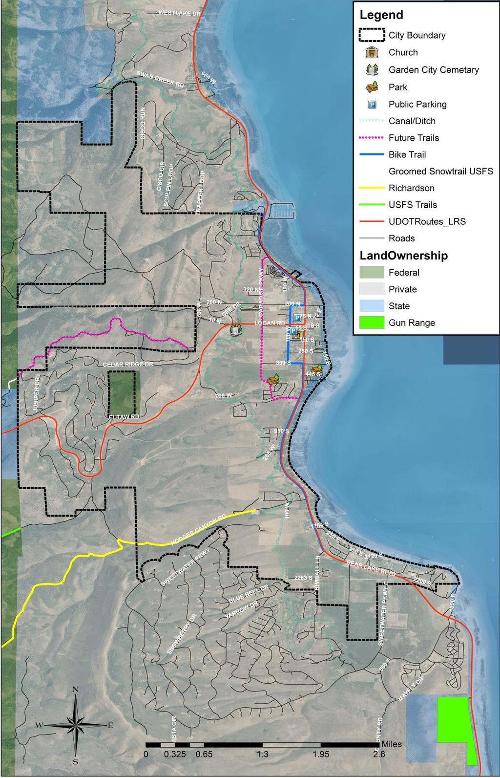
22 Needs Analysis Existing Parks and Facilities Inventory Garden City Park Address: 400 South Bear Lake Blvd Park Amenities: Approximately 11.8 acres Swings Playground equipment Basketball court Sand volleyball Pavilion Picnic tables Grill Restroom Parking area Wetland boardwalk Beach access Maintained by Garden City Opportunities: Potential to increase parking capacity Access to the beach Close to downtown Constraints: Community Park (typical size 8-20 acres) 18
")
 Picnic tables (future) Parking area (future) Opportunities:")
23 Needs Analysis Heritage Park Address: 400 South Paradise Prkwy Park Amenities: Approximately 17 acres Fish pond Fish cleaning station (future) Playground (future) Softball/soccer field (future) Walking paths (future) Benches (future) Picnic tables (future) Parking area (future) Opportunities: Constraints: 19


24 Needs Analysis Special Use Facilities Garden City Swimming Pool Address: 69 N Paradise Parkway Bldg. B Park Amenities: Indoor swimming pool Hot tub Shower Changing rooms Tables and chairs Life guards Opportunities: Constraints: No ADA access 20

 2 trap ranges (future)")
 Veterans memorial (future) Opportunities:")
25 Needs Analysis Bear Lake Gun Range Address: 0.2 miles south of Garden City Park Amenities: Approximately 100 acres 200 yd rifle range (future) 50 yd pistol range (future) 2 trap ranges (future) Parking area (future) Restroom (future) Pavilion (future) Veterans memorial (future) Opportunities: Constraints: 21


26 Needs Analysis Existing Trails Inventory Trail Amenities: 4.2 mile paved trail Benches Trash receptacles Views of surrounding mountains Views of the Lake No motorized vehicles Opportunities: Access to town amenities Access to local businesses Constraints: None Trail Description The trail connects the State Marina on the north to Sweetwater/Ideal Beach on the south. At several places along the trail are benches, trash receptacles, and signs placed for public use. The trail winds its way through downtown Garden City giving pedestrians and bicyclists access to many of the Town s amenities. The total length of the developed trail is approximately 4.2 miles long. 22
27 Needs Analysis Hodge s Canyon West Hodges Canyon Rd Garden City maintains a trailhead to Hodge s Canyon, located approximately 0.5 miles west of HWY 30 on Hodge s Canyon Road. This trail is open to hiking, biking, horseback riding, ATV s, and Snowmobiles. Existing Open Space The City does not currently own any existing open space that is not being utilized as a public park or parking area. 23
28 Proposed Improvements 4. Proposed Improvements for Future Planned Parks, Trails, and Open Space Active Parks Importance of Parks Parks and open space in Garden City are vital to ensure quality community life. They provide recreational opportunities for local residents and beautify the area. They add warmth, peace, and a touch of nature. Open green space is critical to the spiritual and emotional well-being of a city. Parks and open space are often the only places where people take the time to observe the passing scene, meet friends, and celebrate with a wide range of people who are different from themselves. The following is a list of existing and potential future facilities, parks, and open spaces: Park Type Status Acres 1 Heritage Park Community Partially 14 Park Developed 2 Garden City Park Community Park Developed 11.8 Special-Use Facility Type Status Acres 1 Garden City Pool Community Park Developed NA 2 Gun Range Park Undeveloped Future Open Space Opportunity Type Status Acres Proposed Improvements 24
29 Proposed Improvements Existing Active Park Improvements Park Name Recommended Upgrades Estimated Cost Garden City Park Heritage Park Provide increased parking capacity $150,000 Boardwalk repairs and renovations $10,000 Landscaping $8,000 Parking lot east side $130,000 Parking lot west side $125,000 Trails $10,000 Irrigation system $30,000 Landscaping $25,000 playground equipment $15,000 Softball and soccer field $10,000 ADA fishing access $12,000 Fish cleaning stations $800 Garden City Pool ADA access (pool lift) $6,000 Trail Improvements Importance of Trails Trails are playing an even more important role in communities all across America. Among the many reasons are the growing emphasis on health and fitness and the fact that Americans have less and less leisure time to devote to recreational pursuits. There is an increasing demand for recreational opportunities located closer to home. At the same time, there is a parallel demand for open space and passive recreational areas. Greenways and trail systems are ideally suited to meet these needs. Trails provide a means for improving the overall health and fitness of individuals. It has been well documented in the medical literature that introducing even low-intensity activities, such as walking, into people s daily routine can significantly reduce the risk of developing coronary heart disease.1 Other beneficial aspects of walking include stress reduction, weight loss, and the potential for reducing blood pressure. Walking for fitness and recreation has become one of the fastest-growing and most popular activities in America. The National Park Service stated that: 25 "Trails have multiple values whose benefits reach far beyond recreation. Trails can enrich the quality of life for individuals, make communities more
30 Proposed Improvements livable, and protect, nurture, and showcase America's grandeur by traversing areas of natural beauty, distinctive geography, historic significance, and ecological diversity. Trails are important for the nation's health, economy, resource protection, and education, and help meet the needs of a changing society." The abundance of canyons, mountain slopes, and streams provide Garden City residents many opportunities for natural trails and paved bike and pedestrian trails which can connect to community trails as well as regional trails. Future Trailheads All existing parks and public parking lots can be considered as trail heads if trails are developed as planned and could include benches, bicycle racks, and information stations within the parks to indicate that they are a trail head for a particular trail. Consideration should be given to developing a trailhead that links up to the Garden City Canyon trail. Ideally, this trailhead should be located near the intersection of 200 North and 700 West. Open Space Importance of Open Space Open space contributes greatly to the character of a community. Without planning, ill-conceived changes in land-use patterns can dramatically alter a community in a short period of time. Valued natural resources would not be preserved, maintained, and restored; it is only through thoughtful planning and active stewardship that these important resources can be protected. Planning now to protect important open space can greatly enhance the attractiveness of a city and encourage compatible growth in the future. Planning allows cities to confront and manage aspects of growth and development in ways that preserve, protect, and enhance the environment. By planning for open space, residents benefit, and the "green infrastructure" of a community is protected. Planning this "green infrastructure" of water supply, land, working farms and forests, viable wildlife habitats, and greenways is as important to the economic future of a community as planning for schools, roads, water, and wastewater infrastructure. 26


31 Proposed Improvements 27
32 Proposed Improvements Proposed Open Space Passive Open Space Areas within the community should be preserved and/or created for passive recreation. The areas identified include: Landscaped islands along Bear Lake Blvd from approximately 75 North to 75 South across from the church and along Logan Canyon Road from 100 West to the intersection at Bear Lake Blvd. Open space at city office. Natural Open Space Areas of the community, such as along the waterways that flow through the community, could be considered natural open space, and areas within a designated flood plain or wetland should be preserved as natural and passive open space to allow the land to perform its natural function. Winter Recreation Recreation opportunities within Garden City limits are scarce due to the topography and climate of the area. Some opportunities exist for snowmobiling, sledding, and cross-country skiing in the mountains immediately east of the City. The trails being proposed could lead to crosscountry skiing available within City limits depending on the weather and snow depth. Timing for Future Planned Parks, Trails, and Open Space There is no set time recommendation made on the development of park/open space land, and trails. However, the future needs listed for the existing parks and facilities should be considered as priorities when developing future budgets or making grant applications. 28
33 5. Goals, Strategies, and Action Goal Philosophy The goals, strategies, and actions reflect the priorities set forth by the advisory staff, Planning Commission, and City Council. One of the key goals listed in this plan is that priorities for parks, facilities, trails, and open space should be reviewed bi-annually to insure the goals are in line with the current objectives of the community. Additionally, since the priorities of planned goals will shift over time, and new goals may need to be set, the plan itself should experience a comprehensive review and update at least every five years. 29 Funding Opportunities Funding Source Types of Projects UDOT Transportation Enhancement (UDOT) Utah Parks Non- Motorized Trail Grants (Utah State Parks and Recreation) Land and Water Conservation Grant (Utah State Parks and Recreation) LeRay McAllister Grant (Governor s Office of Planning and Budget) Safe Routes to School (UDOT) Safe Sidewalk Program Bikes Belong CIB Rural Development Private Foundations/Corpora tions Trail Development Trail Development Park Development Purchase Land for Open Space Trail/Sidewal k Sidewalks Trails for Bikes Park/Facility and Trail Development Facility Development Park/Facility and Trail Development Application Time September May October May November Quarterly Quarterly No Real Deadline No Real Deadline Match Required 20% Match (cash and/or in-kind is acceptable however this agency likes at least some cash) 50% Match (cash and/or in-kind is acceptable however this agency likes at least some cash) 50% Match (cash and/or in-kind is acceptable however this agency likes at least some cash) Match required (cash and/or in-kind is acceptable however this agency likes some cash) 20% Match (cash match) 25% Match 50% Match (cash match) Like to see a match Very Limited Funds Can apply any time usually like to see some money coming from the community
34 Goals, Strategies, and Actions Goal Categories GOAL 1: Objective 1: Policy/Action Timing Agency Policy A: Policy B: Policy C: Policy D: Policy E: GOAL 2: Objective 1: Policy/Action Timing Agency Policy A: Policy B: Policy C: Policy D: Policy E: 30
1. Parks & Recreation Neighborhood Parks Community Parks Special Use Sites 2. Open Space 3. Trails
 Appendix A: Park Classifications The intent of parks and recreation classifications is to aid in making acquisition and design decisions for park sites, facilities and the organization of recreation space
PARTF Scoring System for Grants
 PARTF Scoring System for Grants The members of the N.C. Parks and Recreation Authority use the PARTF scoring system as one of several tools to select grant recipients. Please provide all of the information
Appendix 1 Woods Cross Parks and Trail Master Plan
 Appendix 1 Woods Cross Parks and Trail Master Plan Appendix 1 Woods Cross Parks and Trail Master Plan... 1 Chapter 1 Introduction... 3 Plan Purpose... 3 The Importance of Parks and Trails... 4 Mission
Chapter 6. Overall Vision RECOMMENDATIONS. More Trail and Trail. Connections. Equal Access to Park. Facilities and Programs. Water Access.
 Overall Vision More Trail and Trail Connections Equal Access to Park Facilities and Programs Water Access Environment Variety Chapter 6 RECOMMENDATIONS Chapter 6 The following recommendations for park,
CITY OF GAINESVILLE PARKS, RECREATION AND CULTURAL AFFAIRS DEPARTMENT VISION 2020
 CITY OF GAINESVILLE PARKS, RECREATION AND CULTURAL AFFAIRS DEPARTMENT VISION 2020 A BLUE PRINT FOR THE NEXT 20 YEARS The PRCA Vision 2020 Master Plan, adopted in November 2012, addresses the current state
Northeast Quadrant Plan
 Northeast Quadrant Plan Northeast Quadrant Distinctive Features Land Use The Northeast Quadrant includes all the area within the planning area that is east of Interstate 5 and to the north of State Route
City Council March 27, Parks, Recreation, and Trails Master Plan
 City Council March 27, 2018 Parks, Recreation, and Trails Master Plan Planning Process Develop Goals and Objectives Inventory of Areas and Facilities Needs Assessment And Identification Public Participation
Neighborhood Districts
 NEIGHBORHOOD DISTRICTS SEVEN MAIN DISTRICTS Neighborhood Districts While the Development Plan provides a broad-scale overview of the neighborhood, this section focuses on uses and relationships at the
The following principles guide the development of goals and strategies to protect and promote these amenities:
 OPEN SPACE/PARKS/TRAILS/RECREATION GOALS/STRATEGIES Cherry Hills Village is a living environment that offers low density development, open areas, public scenic vistas, public trails and public parks. This
10.0 Open Space and Public Realm
 10.0 Open Space and Public Realm 10.0 Open Space and Public Realm The Public Open Space System is comprised of: outdoor spaces available for public use that are either publicly owned (e.g., parks and
Section 3 INVENTORY OF RECREATION LAND AND FACILITIES
 Photo of Juan Bautista de Anza Park Section 3 INVENTORY OF RECREATION LAND AND FACILITIES Summary of Findings Park Definitions Summary of Recreation Facilities Other Recreation Facilities Nearby Recreation
Parks, Open Space and Trails
 Introduction Parks have often been referred as the lungs of our cities, cleansing the air of pollutants and particulate matter. Parks are also gathering places for families and community. They offer spaces
The Five Components of the McLoughlin Area Plan
 The Five Components of the McLoughlin Area Plan This documents contains the complete language of the five components of the McLoughlin Area Plan: The Vision Statement The Values The Guiding Principles
Draft Stillwater 2030 Comprehensive Plan- Goals and Policies
 Draft Stillwater 2030 Comprehensive Plan- Goals and Policies Instructions- Review each goal and policy and discuss with group any changes, deletions for additions to the list using your groups pen. Keep
Mendota Heights 2040 Comprehensive Plan Draft Vers
 4 Parks and Trails The City of Mendota Heights boasts a variety of recreational and open space opportunities. Few cities can claim access to regional trails, riverside and lakeside parks, scenic bluffs
Exhibit A. 8:9 Scuffletown Rural Conservation District
 Exhibit A 8:9 Scuffletown Rural Conservation District 8:9.1 Intent and Purpose The Scuffletown Rural Conservation (SRC) District is intended to provide for residential development that supports the development
3. VISION AND GOALS. Vision Statement. Goals, Objectives and Policies
 Vision Statement Queen Creek s interconnected network of parks, trails, open spaces and recreation opportunities provide safe and diverse activities and programs that sustain its unique, small town, equestrian
Parks, and Recreation & Cultural Arts Master Plan Update
 Parks, and Recreation & Cultural Arts Master Plan Update Community Profile Public Input Summary: Staff Interviews conducted April 14 and 15, 2014 Citizens Workshop - conducted April 15 th and 24 th, May
SEWRPC OUTDOOR RECREATION AND OPEN SPACE PLANNING OBJECTIVES, PRINCIPLES, AND STANDARDS
 SEWRPC OUTDOOR RECREATION AND OPEN SPACE PLANNING OBJECTIVES, S, AND STANDARDS Introduction The Southeastern Wisconsin Regional Planning Commission (SEWRPC), as part of the regional park and open space
ADOPTED CAPITAL IMPROVEMENT PROGRAM BUDGET ARROYO PROJECTS
 ADOPTED CAPITAL IMPROVEMENT PROGRAM BUDGET ARROYO PROJECTS HAHAMONGNA FY 212-216 Capital Improvement Program Priority Description Total Estimated Costs Appropriated Through FY 211 Adopted FY 212 FY 213
EL DORADO COUNTY GENERAL PLAN PARKS AND RECREATION ELEMENT PRINCIPLE INTRODUCTION STATE AUTHORIZATION
 EL DORADO COUNTY GENERAL PLAN PARKS AND RECREATION ELEMENT PRINCIPLE The General Plan must identify the types of governmental services, including parks and recreation facilities, which are necessary to
Southeast Quadrant Plan
 Southeast Quadrant Plan Southeast Quadrant Distinctive Features Land Use The Southeast Quadrant includes all the area within the planning area that is east of Interstate 5 and south of State Route 44.
A citizen s guide to the. Comprehensive Plan. City of Lakeville, Minnesota 1
 A citizen s guide to the Comprehensive Plan 2008 City of Lakeville, Minnesota 1 Introduction The City of Lakeville completed an update of its Comprehensive Plan in 2008. A comprehensive plan is a tool
This page intentionally blank.
 This page intentionally blank. Parks, Recreation, and Open Space Chapter Relationship to Vision Vision Parks, Recreation and Open Space Chapter Concepts County Government. County government that is accountable
PARKS. Chapter Introduction
 Chapter 4. PARKS 4.1. Introduction This Parks Element of the 2016 Comprehensive Plan Update provides direction and guidance, based on citizen input, in order to improve and maintain the City s existing
STAFF RECOMMENDATION: Adopt the Parks and Recreation Master Plan 2013, or take other action as deemed appropriate.
 Regular 7. CITY COUNCIL AGENDA Meeting Date: 12/02/2013 TITLE: Parks and Recreation Master Plan 2013 Adoption Proposal - Dwight Curtis Responsible Staff: Dwight Curtis Backup Material: Backup material
The urban parks in Charlottesville include Jackson Park, Lee Park, and McGuffey Park.
 Park Classifications Charlottesville s parks can be grouped into 4 different classifications: urban parks, neighborhood parks, community parks, and regional parks. Figure 1 on page 5 inventories the facilities
GOALS, OBJECTIVES, POLICIES & PROGRAMS
 Chapter 5 GOALS, OBJECTIVES, POLICIES & PROGRAMS 5.1 Goals, Objectives, Policies & Programs This is a joint plan adopted by both the Village of Waunakee and the Town of Westport. Both communities will
Little Neck Planning Area
 Little Neck Planning Area Current Reality The Little Neck Planning Area is characterized by established residential neighborhoods, Town Center and Pembroke. The Eastern and Western Branches of the Lynnhaven
Comprehensive Parks and Recreation Master Plan. Executive Summary. Submitted To: City of Milton, GA October 2012
 Comprehensive Parks and Recreation Master Plan Executive Summary Submitted To: City of Milton, GA October 2012 Executive Summary The City of Milton envisioned the need for an effective Master Planning
Appendix A. Park Land Definitions
 Appendix A Park Land Definitions Mini Park May serve specific function for any and all ages, depending on need of the user area. Size range 1-5 acres with optimum size being 3 acres. Service area is sub-neighborhood
4.1 AESTHETICS AND VISUAL QUALITY
 SCOPE AND METHODOLOGY 4.1 AESTHETICS AND VISUAL QUALITY This section evaluates the potential impacts to aesthetics and visual quality. Aesthetics refers to visual resources and the quality of what can
Port Lavaca Future Land Use
 Port Lavaca Future Land Use Introduction The City of Port Lavaca is beginning to see sustained growth, after many years of relative stable population. New single family homes, apartments, and businesses
Durango Parks & Recreation Department. Strategic Plan
 Durango Parks & Recreation Department Strategic 2019-2023 Adopted April 2019 Overview The purpose of the adopted 2010 Parks, Open Space, Trails and Recreation Master is to provide a 10-year road map for
Courthouse Planning Area
 Courthouse Planning Area Current Reality The Courthouse Planning Area is the characterized by expansive suburbanscale residential areas as well as the community resource planned area of athletic, educational,
EXISTING COMPREHENSIVE PLAN
 EXISTING COMPREHENSIVE PLAN Town Center Land Use Element: V. LAND USE POLICIES Town Center Mercer Island's business district vision as described in "Your Mercer Island Citizen-Designed Downtown" was an
ARTICLE IV: DEVELOPMENT STANDARDS 404 MASTER PLANNING
 IV 13 404 MASTER PLANNING Master Planning through the Site Analysis (Master Planning Site Analysis) or Planned Development (Master Planning Planned Development) is provided to encourage development which
RECREATION AND OPEN SPACE ELEMENT GOALS, OBJECTIVES, AND POLICIES
 RECREATION AND OPEN SPACE ELEMENT GOALS, OBJECTIVES, AND POLICIES Goal 7 To provide park facilities, recreation programs, and open space resources that are safe, adequate, and accessible to all City residents,
Applicant Name Phone / Fax / Address City State Zip Code . Property Owner Phone / Fax / Address City State Zip Code
 Master Development Plan Application Community Development Department City of Redmond 411 SW 9 th Street Redmond, Oregon 97756 541-923-7721 541-548-0706 FAX Master Development Plan Fee $38,862.52 File Number
4-Town Comprehensive Plan DRAFT 7/30/07
 4-Town Comprehensive Plan DRAFT 7/30/07 Acknowledgements ning Committee Town of Harrisburg Norman Roof Randy Nicol Town of Martinsburg Terry Thisse Paul Kelly Town of Montague Jan Bagdanowicz Wendy Perry
Focus Groups. 8 Focus Group meetings including 2 with staff, 1 with seniors, and 1 with students
 Project Team Nan Lanahan, Parks & Recreation Jason Gallo, Parks & Recreation Rob Leslie, DEDP John Smolinsky, Planning Board Brent Meredith, Highway Joan Gavrilik, Friends of Parks & Rec MaryLyn Koval,
Improve Neighborhood Design and Reduce Non Point Source Water Pollution
 HOW TO Planning Guide Improve Neighborhood Design and Reduce Non Point Source Water Pollution This document was funded by a grant from the New Hampshire Coastal Program with funding from the National Oceanic
OPEN SPACE AND RECREATION
 OPEN SPACE AND RECREATION The Town celebrates and maintains the spectacular visual character of our Sonoran Desert setting and we value our open space, mountain views, washes, vegetation, and wildlife.
The transportation system in a community is an
 7 TRANSPORTATION The transportation system in a community is an important factor contributing to the quality of life of the residents. Without a sound transportation system to bring both goods and patrons
Section Three Recreation Standards & Needs Assessment
 Section Three Recreation Standards & Needs Assessment William M. Hargraves Center Introduction This section contains the analysis and assessment on which the recommendations of this Comprehensive Parks
Asbury Chapel Subdivision Sketch Plan
 Asbury Chapel Subdivision Sketch Plan PART 1: PROJECT SUMMARY Applicant: NVR Inc. Project Size: +/- 76.13 acres Parcel Numbers: 02101112,02116101,02116112, 02116113 Current Zoning: Transitional Residential
Town of Peru Comprehensive Plan Executive Summary
 Town of Peru Comprehensive Plan Executive Communities that plan grow by choice, not by chance. A plan makes growth thoughtful, understandable, and predictable. A plan shows that a community is managing
Provide and maintain sufficient public parks, recreation facilities, and open space to meet the recreational needs of County residents and visitors.
 (ROS) Goal Provide and maintain sufficient public parks, recreation facilities, and open space to meet the recreational needs of County residents and visitors. OBJECTIVE ROS.01 The County shall acquire,
PIERCE COUNTY IMPACT FEE WORKING GROUP. Pierce County s Park System
 PIERCE COUNTY IMPACT FEE WORKING GROUP Pierce County s Park System Project Title 2/25/2016 1 Pierce County s Park System Park System Concept Park Classifications Current Park Inventory Park System Comparison
SALISBURY TOMORROW Our Vision
 SALISBURY TOMORROW Our Vision Salisbury is committed to supporting a high quality of life and sense of community for all residents. These commitments need to be reflected in our community programs, services
PREVIOUS PUBLIC PARTICIPATION BRIEF October 2014
 Comprehensive Planning During the development of the county comprehensive plan, Cultivating Community: A Plan for Union County s Future from 2007 through 2009, and three concurrent multi municipal plans
(ALL TIMES LISTED ARE APPROXIMATE AND SUBJECT TO CHANGE. )
") AGENDA TANGENT CITY COUNCIL AND PLANNING COMMISSION JOINT PUBLIC HEARING Wednesday March 16, 2011 PARK COMMISSION SESSION 7:00 p.m.. Bass Estate 32166 Old Oak Drive, Tangent, OR 97389 (ALL TIMES LISTED
AGENDA TANGENT CITY COUNCIL AND PLANNING COMMISSION JOINT PUBLIC HEARING Wednesday March 16, 2011 PARK COMMISSION SESSION 7:00 p.m.. Bass Estate 32166 Old Oak Drive, Tangent, OR 97389 (ALL TIMES LISTED
North Oakville East Parks Facilities Distribution Plan. November, 2009
 North Oakville East November, 2009 POLICY CONTEXT 1) Purpose a) The purpose of this document is to be a guide for the location, configuration, design and development of the parks system for the North Oakville
T O W N O F H I G H R I V E R
 T O W N O F H I G H R I V E R o p e n s p a c e p l a n The Town of High River, 30 minutes South of Calgary, still retains much of its distinctive small town character and provides residents with a high
Chapter Purpose and Intent. 7.2 Applicability. 7.3 General Provisions RECREATIONAL OPEN SPACE
 Chapter 7. RECREATIONAL OPEN SPACE 7.1 Purpose and Intent The intent of this Chapter is to provide for centrally located, unencumbered land as neighborhood recreational open space and not to permit the
PARKS AND RECREATION
 PARKS AND RECREATION WHAT YOU WILL FIND IN THIS CHAPTER: Background information on the development of the Park, Recreation, and System Plan (PRSP). General overview of Ellensburg s parks and recreation
CARMODY PARK MASTER PLAN
 the site Smith Reservoir Cottonwood Lake Kendrick Lake Carmody Rec Center Carmody Middle School Pool Court Play Carmody Pond Sanderson Ditch Sports Fields Foothills Ice Arena Open Field why a master plan?
3.2 P - Park District
 3.2 P - Intent - The P: s are established to promote and maintain the development of recreational opportunities within the. The development of new parks or the major expansion of existing parks within
ARROYO PROJECTS ADOPTED CAPITAL IMPROVEMENT PROGRAM BUDGET
 A RROYO P ROJECTS ADOPTED CAPITAL IMPROVEMENT PROGRAM BUDGET FISCAL YEARS 214-218 HAHAMONGNA Priority Description 1 Hahamongna Watershed Park - Implement Master Plan 211,6 211,6 (77565) 2 Hahamongna -
APPENDIX D2: PARKS AND TRAILS
 APPENDIX D2: PARKS AND TRAILS Cultivate Hopkins Comprehensive Plan 8/15/18 DRAFT Cultivate Hopkins Appendix D2 1 Existing Conditions Local Parks and Trails Figure D2.1 shows the existing park and trail
Appendix D OUTDOOR RECREATION AND OPEN SPACE PLANNING OBJECTIVES, PRINCIPLES, AND STANDARDS FOR WASHINGTON COUNTY
 Appendix D OUTDOOR RECREATION AND OPEN SPACE PLANNING OBJECTIVES, S, AND FOR WASHINGTON COUNTY OBJECTIVE NO. 1 The provision of an integrated system of public -use outdoor recreation sites and related
BROOKHILL NEIGHBORHOOD MODEL ZONING MAP AMENDMENT PREFACE TO APPLICATION
 BROOKHILL NEIGHBORHOOD MODEL ZONING MAP AMENDMENT PREFACE TO APPLICATION June 15, 2015 Revised: August 1, 2016 I. VISION Brookhill is a proposed community based upon the principles of Albemarle County
Comprehensive Park System Master Plan
 PARKS AND RECREATION Comprehensive Park System Master Plan Citizen Advisory Committee, June 5, 2012 - Meeting Notes Transcription MIG met with the Parks Citizen Advisory Committee on Tuesday, June 5th,
Silverdale Regional Center
 Silverdale Regional Center Vision for Silverdale Regional Center The Silverdale Regional Center Plan (Plan) will guide the evolution of the Silverdale Regional Center from a collection of strip malls and
Pungo/Blackwater Planning Area
 Pungo/Blackwater Planning Area Current Reality The Pungo/Blackwater Planning Area represents the rural landscape and lifestyle that encompasses nearly 40% of Virginia Beach. The Agricultural Reserve Program
PARKS & RECREATION SUBCOMMITTEE. Oct. 1, 2015
 PARKS & RECREATION SUBCOMMITTEE Oct. 1, 2015 1999 Bond - $22,000,000 Land Acquisition Allen Station Phase II Neighborhood Parks PREVIOUS BOND ELECTIONS 1999 & 2007 2002 Bond - $4,000,000 Allen Senior Recreation
6. RECREATION AND OPEN SPACE ELEMENT
 6. RECREATION AND OPEN SPACE Introduction This Recreation and Open Space Element includes Goals, Objectives and Policies (GOP) that apply to the main campus in Gainesville and the Lake Wauburg Recreation
G. RECREATION AND OPEN SPACE ELEMENT. The following summarizes the Recreation and Open Space Element:
 G. RECREATION AND OPEN SPACE ELEMENT The purpose of the Element is to provide the framework and direction for a comprehensive system of public and private sites for recreation, including, but not limited
Gold Line Bus Rapid Transit Transit Oriented Development (BRTOD) Helmo Station Area Plan
 Helmo Station Area Plan") Appendix F Gold Line Bus Rapid Transit Transit Oriented Development (BRTOD) Helmo Station Area Plan Introduction and Purpose of the Plan The Gold Line Bus Rapid Transit facility is an eleven-mile dedicated
Appendix F Gold Line Bus Rapid Transit Transit Oriented Development (BRTOD) Helmo Station Area Plan Introduction and Purpose of the Plan The Gold Line Bus Rapid Transit facility is an eleven-mile dedicated
Charles P. Johnson and Associates. Annapolis Landscape Architects
 Charles P. Johnson and Associates Annapolis Landscape Architects AGENDA Introduction Project Limits and Scope Site Analysis Opportunities & Constraints Program Goals Image Boards Design Alternatives Pros
Chapter 5: Recreation
 Chapter 5: Recreation Introduction and Setting Recreational opportunities within Nevada County are varied, ranging from public parks with intensively used active recreational facilities, to vast tracts
Section 9 NEIGHBORHOOD DESIGN
 Section 9 NEIGHBORHOOD DESIGN City of Lancaster Comprehensive Plan D u n k i n, S e f k o & A s s o c i a t e s, I n c. NEIGHBORHOOD DESIGN INTRODUCTION There are many ways in which a neighborhood can
6.0 PARKS AND RECREATION
 6.1 INTRODUCTION offers a combination of regional parklands and Town parks, as well as a range of recreation and leisure programs for its residents. Marin County s extensive open space lands and preserves
Citizen s Advisory Committee
 Citizen s Advisory Committee 13 Members 6 Meetings (5 Locations) 1 Public Meeting Numerous Report Drafts Countless Hours of Review Immeasurable Input Special Thank You To: Jack Cohen Brian Kile George
Appendix A Goals and Policies
 Appendix A Goals and Policies i This page left blank intentionally Introduction This Appendix lists the Goals and Policies from the adopted 1996 Parks and Recreation Master Plan. The Parks and Recreation
RECREATION AND OPEN SPACE VISION
 City of South Lake Tahoe General Plan Policy Document Recreation and Open Space Element INTRODUCTION This element provides the policy context for the City of South Lake Tahoe to achieve its vision for
Yadkin River Greenway Feasibility Study Fact Sheet Village of Clemmons, Town of Lewisville, Town of Bermuda Run
 Fact Sheet Village of Clemmons, Town of Lewisville, Town of Bermuda Run Project Background The Yadkin River Greenway Feasibility Study is a joint project with the Village of Clemmons, the Town of Bermuda
Arlington, Virginia is a worldclass
 EXECUTIVE S U M M A RY Arlington maintains a rich variety of stable neighborhoods, quality schools and enlightened land use policies, and received the Environmental Protection Agency s highest award for
Wasatch CHOICE for 2040
 Wasatch CHOICE for 2040 Economic Opportunities We Can Choose a Better Future We enjoy an unparalleled quality of life along the Wasatch Front. People from all over the world are drawn to our stunning scenery,
Kempsville Planning Area
 Kempsville Planning Area Current Reality The Kempsville Planning Area is by far the most populated planning area in the City. The preservation of the 1,422 Stumpy Lake Natural Area, the largest City-owned
Outdoor Recreation Facilities Inventory
 Outdoor Recreation Facilities Inventory Allouez Neighborhood Parks: East Lawn Park (4.90 acres) is located in the northeastern corner of Allouez near Boyd Street. This site contains: Baseball diamond with
7.0 Parks, Recreation and Trails
 7.0 Parks, Recreation and Trails City of Becker Comprehensive Plan Parks, Recreation and Trails Page 109 Left Blank Intentionally Page 110 City of Becker Comprehensive Plan Parks, Recreation and Trails
COMMUNITY DESIGN. GOAL: Create livable and attractive communities. Intent
 COMMUNITY DESIGN Intent An attractive, well-designed County will attract quality development, instill civic pride, improve the visual character of the community, and create a strong, positive image for
Policies and Code Intent Sections Related to Town Center
 Policies and Code Intent Sections Related to Town Center The Town Center Vision is scattered throughout the Comprehensive Plan, development code and the 1994 Town Center Plan. What follows are sections
Long Branch-Wayne Local Park Renovation Project
 Montgomery Parks Long Branch-Wayne Local Park Renovation Project Community Meeting #2 September 20, 2016 Oak View Elementary School 7:00-9:00 PM Welcome / Team Introductions M-NCPPC (Montgomery Parks)
RECREATION AND OPEN SPACE ELEMENT
 RECREATION AND OPEN SPACE ELEMENT Last amended August 19, 2008 Table of Contents Objective Page 5.1 Park system defined... 5-1 5.2 Access to parks and recreational facilities... 5-2 5.3 Recreation and
ANCHORAGE PARK REPORT CARD Assessing A Park s Appearance, Function, & Condition
 ANCHORAGE PARK REPORT CARD Assessing A Park s Appearance, Function, & Condition Park Name: Is Your Park an A or an F? Your Name: Contact Information Optional: Date: General Instructions: Phone: Email:
Chapter 2: Vision, Goals and Strategies
 Chapter 2: Vision, Goals and Lake Elmo Today & Tomorrow Comprehensive Plan 2040 2 VISION, GOALS & STRATEGIES - DRAFT 4-6-2018 INTRODUCTION Comprehensive Plan Purpose Perhapse the most important objective
CHAPPLES PARK MASTER PLAN
 CHAPPLES PARK MASTER PLAN Presentation of Preliminary Development Options Public Open House #2 Wednesday November 2 nd, 2016 TONIGHT S AGENDA 1. Welcome & Introductions 2. Presentation by Sierra Planning
The Vision. Photo provided by The Minervini Group. 46 Vision, Objectives & Strategies
 Vision, Objectives & Strategies The is the public framework and guide for future development of the Grand Traverse Commons. The establishes public polices for infrastructure, the preservation of natural
Park Types and Attributes
 02 APPENDIX B APPENDIX B s and s 194 APPENDIX B 04 Size Level of Service Any privately owned park, of any size, is a neighborhood park Primary Service Area - 1/2 mile or within 15 minutes walking distance
Clair-Maltby Community visioning
 Clair-Maltby Community visioning workshop #1 Summary April 27th, 2017 Table of Contents INTRODUCTIon 1 PURPOSE 1 CONSULTATION STRUCTURE 2 PARTICIPANT FEEDBACK 3 VISIONING EXERCISE 8 ONLINE SURVEY RESULTS
The Illinois Department of Transportation and Lake County Division of Transportation. Route 173, including the Millburn Bypass
 The Illinois Department of Transportation and Lake County Division of Transportation welcome you to this Public Hearing for U.S. Route 45 from Illinois Route 132 to Illinois Route 173, including the Millburn
Ten Mile Creek Planning Area
 PLANNING AREA POLICIES TEN MILE CREEK Ten Mile Creek Planning Area Location and Context The Ten Mile Creek Planning Area ( Ten Mile Creek area ) is located south of the current Boise AOCI, generally south
SECTION II SECTION II STATEMENT OF GOALS, OBJECTIVES, PRINCIPLES, ASSUMPTIONS, POLICIES AND STANDARDS
 STATEMENT OF GOALS, OBJECTIVES, PRINCIPLES, ASSUMPTIONS, POLICIES AND STANDARDS 1 2 STATEMENT OF GOALS, OBJECTIVES, PRINCIPLES, ASSUMPTIONS, POLICIES AND STANDARDS INTRODUCTION The New Jersey Municipal
Canal Winchester Parks Master Plan. Public Meeting 2 Thursday, February 2 6:30pm
 Canal Winchester Parks Master Plan Public Meeting 2 Thursday, February 2 6:30pm Meeting Agenda 1. Project overview 2. Project schedule 3. Public input results Survey Public Meeting #1 Stakeholder Interviews
2011 ASLA Design Awards. Centennial Park Merit Award Design Concepts CLA, Inc. Design over $500,000 Construction Budget
 2011 ASLA Design Awards Centennial Park Merit Award Design Concepts CLA, Inc. Design over $500,000 Construction Budget 2011 ASLA Colorado Professional Design Awards Project Name: Category: Location: Const.
Throughout. square. (Crystal City Vision Plan 2050)
") 1: Terms related to the PSMP document 1 public space (see also public realm, civic space) An open space designated on the regulating plan, accessible to all, including Plazas, Mini Parks, and Neighborhoods
1: Terms related to the PSMP document 1 public space (see also public realm, civic space) An open space designated on the regulating plan, accessible to all, including Plazas, Mini Parks, and Neighborhoods
Parks, Recreation, & Open Space
 Parks, Recreation, & Open Space A functional and accessible system of parks, open space, and recreational facilities GOAL: Develop and maintain an extensive system of interconnected parks and public spaces,
OPEN SPACE CHAPTER 7: OVERVIEW. Preserve open space to protect natural resources, enhance character and provide passive recreation opportunities
 CHAPTER 7: OPEN SPACE OVERVIEW Ridgefield has made tremendous progress permanently preserving areas of town as open space. Open space preservation can serve many important purposes, including: protect