open public hearing and allow public comment request to continue LPA public hearing to January 16, 2014 at 10:30 am
|
|
|
- Darlene James
- 5 years ago
- Views:
Transcription

1 TODAY S AGENDA Work Session LPA Transmittal Public Hearing open public hearing and allow public comment request to continue LPA public hearing to January 16, 2014 at 10:30 am staff will issue a recommendation in January BCC Transmittal Public Hearing - January 28, 2014


2 PRESENTATION OUTLINE Staff Presentation Challenges Considerations Concepts Applicant Presentation Community Perspective LPA Discussion

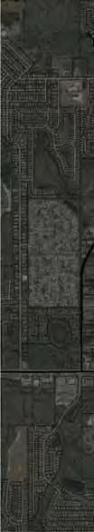
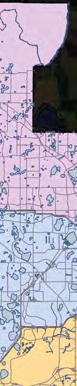
3 PROJECT AREA THE REGIONAL CONTEXT
 Community Meetings:")


")
4 COMMUNITY MEETINGS Three (3) Community Meetings: October 16, November 13, and December 11 Meeting 1: General Overview of Text and Map Amendments (Urban Transect) Meeting 2: Concept Plans A and B (Urban Transect) Meeting 3: Concept Plan (Rural Transition)


5 PRESENTATION STRUCTURE Staff Presentation Challenges Considerations Concepts Applicant Presentation Community Perspective LPA Discussion
 LAKE PICKETT")


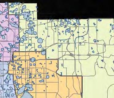
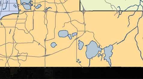
6 EXISTING CONTEXT UCF (LESS THAN 2 MILES) LAKE PICKETT RURAL SETTLEMENT LAKE PICKETT DR BITHLO RURAL SETTLEMENT COLONIAL DR CORNER LAKE RURAL SETTLEMENT URBAN SERVICE BOUNDARY
 LAKE")


7 ECONLOCKHATCHEE RIVER UCF (LESS THAN 2 MILES) LAKE PICKETT RURAL SETTLEMENT LAKE PICKETT DR BITHLO RURAL SETTLEMENT COLONIAL DR CORNER LAKE RURAL SETTLEMENT URBAN SERVICE BOUNDARY

8 OPEN SPACE & CONSERVATION UCF (LESS THAN 2 MILES) LAKE PICKETT RURAL SETTLEMENT LAKE PICKETT DR BITHLO RURAL SETTLEMENT COLONIAL DR CORNER LAKE RURAL SETTLEMENT URBAN SERVICE BOUNDARY
 LAKE PICKETT")


9 EXISTING NETWORK UCF (LESS THAN 2 MILES) LAKE PICKETT RURAL SETTLEMENT LAKE PICKETT DR BITHLO RURAL SETTLEMENT COLONIAL DR CORNER LAKE RURAL SETTLEMENT URBAN SERVICE BOUNDARY
 LAKE PICKETT RURAL SETTLEMENT LAKE")

10 URBAN BOUNDARY PRESSURE UCF (LESS THAN 2 MILES) LAKE PICKETT RURAL SETTLEMENT LAKE PICKETT DR BITHLO RURAL SETTLEMENT COLONIAL DR CORNER LAKE RURAL SETTLEMENT URBAN SERVICE BOUNDARY


11 RESIDENTIAL PRESSURE UCF (LESS THAN 2 MILES) LAKE PICKETT RURAL SETTLEMENT LAKE PICKETT DR BITHLO RURAL SETTLEMENT COLONIAL DR CORNER LAKE RURAL SETTLEMENT URBAN SERVICE BOUNDARY


12 COMMERCIAL PRESSURE UCF (LESS THAN 2 MILES) LAKE PICKETT RURAL SETTLEMENT LAKE PICKETT DR BITHLO RURAL SETTLEMENT COLONIAL DR CORNER LAKE RURAL SETTLEMENT URBAN SERVICE BOUNDARY
 LAKE PICKETT RURAL SETTLEMENT LAKE")

13 PROTECTION OF RURAL SETTLEMENTS UCF (LESS THAN 2 MILES) LAKE PICKETT RURAL SETTLEMENT LAKE PICKETT DR BITHLO RURAL SETTLEMENT COLONIAL DR CORNER LAKE RURAL SETTLEMENT URBAN SERVICE BOUNDARY

14 CHALLENGES RECENT APPLICATIONS 2009 Rybolt New Ideas Lake Pickett North Urban Transect Rural Transition Residential 5,000 du 223 du 3,200 du 5,390 du 4,961 du Nonresidential 2,225,000 s.f. N/A 200,000 s.f. 740,000 s.f. 250,000 s.f. Gross acreage 1,441 acres 223 acres 1,441 acres 2,677 acres 2,677 acres Result of Application Denied at Transmittal Withdrawn by Applicant Insufficient Application Replaced by Rural Transition In Process
15 CHALLENGES RECENT APPLICATIONS 2009 Rybolt New Ideas Lake Pickett North Urban Transect Rural Transition Residential 5,000 du 223 du 3,200 du 5,390 du 4,961 du Nonresidential 2,225,000 s.f. N/A 200,000 s.f. 740,000 s.f. 250,000 s.f. Gross acreage 1,441 acres 223 acres 1,441 acres 2,677 acres 2,677 acres Result of Application Denied at Transmittal Withdrawn by Applicant Insufficient Application Replaced by Rural Transition In Process
16 CHALLENGES RECENT APPLICATIONS 2009 Rybolt New Ideas Lake Pickett North Urban Transect Rural Transition Residential 5,000 du 223 du 3,200 du 5,390 du 4,961 du Nonresidential 2,225,000 s.f. N/A 200,000 s.f. 740,000 s.f. 250,000 s.f. Gross acreage 1,441 acres 223 acres 1,441 acres 2,677 acres 2,677 acres Result of Application Denied at Transmittal Withdrawn by Applicant Insufficient Application Replaced by Rural Transition In Process


17 CHALLENGES RECENT APPLICATIONS 2009 Rybolt New Ideas Lake Pickett North Urban Transect Rural Transition Residential 5,000 du 223 du 3,200 du 5,390 du 4,961 du Nonresidential 2,225,000 s.f. N/A 200,000 s.f. 740,000 s.f. 250,000 s.f. Gross acreage 1,441 acres 223 acres 1,441 acres 2,677 acres 2,677 acres Result of Application Denied at Transmittal Withdrawn by Applicant Insufficient Application Replaced by Rural Transition In Process
18 CHALLENGES RECENT APPLICATIONS 2009 Rybolt New Ideas Lake Pickett North Urban Transect Rural Transition Residential 5,000 du 223 du 3,200 du 5,390 du 4,961 du Nonresidential 2,225,000 s.f. N/A 200,000 s.f. 740,000 s.f. 250,000 s.f. Gross acreage 1,441 acres 223 acres 1,441 acres 2,677 acres 2,677 acres Result of Application Denied at Transmittal Withdrawn by Applicant Insufficient Application Replaced by Rural Transition In Process
19 PRESENTATION STRUCTURE Staff Presentation Challenges Considerations Concepts Applicant Presentation Community Perspective LPA Discussion


20 CONSIDERATIONS Provision of infrastructure and services - Transportation facilities - Water and wastewater - School Capacity Sprawl criteria Goal of infill and redevelopment within the Urban Service Area Context sensitive/compatibility Impact of the proposal on surrounding areas Demand for development Adjacency to Seminole County Consistency with the Comprehensive Plan


21 PRESENTATION STRUCTURE Staff Presentation Challenges Considerations Concepts Applicant Presentation Community Perspective LPA Discussion
 is")


22 CONCEPTS The Rural Transition (RT) is intended for areas where an urban scale of development may be appropriate, but where compatibility, natural resources and/or infrastructure conditions suggest a rural to urban transition may be more appropriate.
 LAKE")


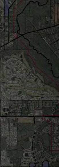
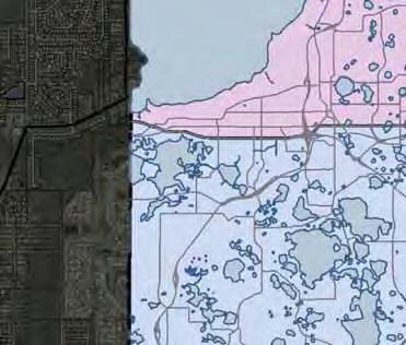
23 PROPOSED TRANSITION ZONE UCF (LESS THAN 2 MILES) LAKE PICKETT RURAL SETTLEMENT LAKE PICKETT DR BITHLO RURAL SETTLEMENT COLONIAL DR CORNER LAKE RURAL SETTLEMENT URBAN SERVICE BOUNDARY


24 CONCEPTS 1. ENVIRONMENTAL PROTECTION 2. DEVELOPMENT CLUSTERING 3. COMPLETE COMMUNITIES 4. WALKABLE NEIGHBORHOODS


25 UCF (LESS THAN 2 MILES) LAKE PICKETT RURAL SETTLEMENT LAKE PICKETT DR BITHLO RURAL SETTLEMENT COLONIAL DR CORNER LAKE RURAL SETTLEMENT URBAN SERVICE BOUNDARY ENVIRONMENTAL PROTECTION


26 OPEN SPACE MASTER PLANNING CREDIT: FCCDR.USF.EDU

27 UCF (LESS THAN 2 MILES) LAKE PICKETT RURAL SETTLEMENT LAKE PICKETT DR BITHLO RURAL SETTLEMENT COLONIAL DR CORNER LAKE RURAL SETTLEMENT URBAN SERVICE BOUNDARY DEVELOPMENT CLUSTERING


28 DEVELOPMENT PATTERNS A B C LOW DENSITY NEIGHBORHOODS CONSERVATION NEIGHBORHOODS TRADITIONAL NEIGHBORHOODS


29 E C A B D COMPLETE COMMUNITIES


30 WALKABLE NEIGHBORHOODS


31 SUMMARY CHALLENGES CONSIDERATIONS CONCEPTS

32 CURRENT APPLICATION
33 PRESENTATION STRUCTURE Staff Presentation Challenges Considerations Concepts Applicant Presentation Community Perspective LPA Discussion
34 PRESENTATION STRUCTURE Staff Presentation Challenges Considerations Concepts Applicant Presentation Community Perspective LPA Discussion
35 PRESENTATION STRUCTURE Staff Presentation Challenges Considerations Concepts Applicant Presentation Community Perspective LPA Discussion


36 NEXT STEPS Work Session LPA Transmittal Public Hearing open public hearing and allow public comment request to continue LPA public hearing to January 16, 2014 at 10:30 am staff will issue a recommendation in January BCC Transmittal Public Hearing - January 28, 2014


37 Work Session Agenda Format Application Background/Chronology Proposed RT Policies Development Program and Concept Plan Existing/Projected Transportation Conditions Question and Answer
38 Proposed RT Policies RT Policy Framework Introduction 1. RURAL TRANSITION 2. ENVIRONMENTAL PROTECTION 3. DEVELOPMENT CLUSTERING 4. COMPLETE COMMUNITIES 5. WALKABLE NEIGHBORHOODS 6. PROCESS

39 Proposed RT Policies RT Policy Framework Introduction 1. Rural Transition Designation Applicable County Wide 2. Core Concepts Expressed in Policy 3. Transmittal Based on Core Concepts 4. Core Concepts Refined/Expanded between Transmittal and Adoption


40 Proposed RT Policies RT Policy Framework Introduction 1. What does Transmittal include: Rural Transition Policies Three FLU Map Amendments 2. What does Transmittal not include: Conceptual Master Plan Development Program (4,961 dwellings/250,000 sq. ft. nonresidential


41 Proposed RT Policies RT Policy Framework Introduction 1. What does the RT Policies require concurrent with Adoption: Conceptual Master Plan Property Specific Development Program Transportation, Utilities, Public School and Adequate Public Facilities Master Plans and Term Sheets/Agreements
42 Proposed RT Policies RT Policy Framework Main Concepts 1. RURAL TRANSITION/COMPLETE COMMUNITIES Policy Development Framework. All proposed RT areas shall be in the form of one or more communities containing a mix of neighborhoods, interconnected open space systems, adequate public facilities and a balance of neighborhood serving non-residential uses including the following: (continues)
43 Proposed RT Policies RT Policy Framework Main Concepts 1. RURAL TRANSITION/COMPLETE COMMUNITIES Policy Residential Density. As a transitional area between rural and urban served uses, the [maximum] residential [yield]shall be 2.5 dwelling units per net acre as a balance between rural densities and minimum urban densities. Densities shall include the following: Neighborhood density up to 6 dwelling units per net acre. Community center density of up to 12 dwelling units per net acre.
44 Proposed RT Policies RT Policy Framework Main Concepts 1. RURAL TRANSITION/COMPLETE COMMUNITIES Policy Non-Residential Development. Non-residential development shall be permitted in community center(s) as follows: Permitted uses include commercial, employment, residential, lodging and civic uses. Maximum area for a community center is 35 net acres. Maximum gross square footage permitted in a community center is 50,000 square feet.


45 Proposed RT Policies RT Policy Framework Main Concepts 2. ENVIRONMENTAL PROTECTION Policy Open Space. Each community in the RT shall have an interconnected open space system comprised of wetlands, flood plain, storm water management facilities, park lands and preserved uplands. Each community shall have a total of 50% open space. (continues)
46 Proposed RT Policies RT Policy Framework Main Concepts 2. ENVIRONMENTAL PROTECTION Policy Storm Water Management. Drainage facilities in the RT shall exceed the standards for the St. Johns River Water Management District and Orange County and include low impact development best management practices for water quality.

47 Proposed RT Policies RT Policy Framework Main Concepts 3. DEVELOPMENT CLUSTERING/WALKABLE NEIGHBORHOODS Policy Neighborhood Development. All residential development will emphasize a pedestrian orientation including an interconnected trail and sidewalk system with walkable destinations including schools, parks and civic uses. Policy Size. Neighborhoods should not exceed 120 acres.
48 Proposed RT Policies RT Policy Framework Main Concepts 4. PROCESS Policy Conceptual Master Plan. To facilitate coordinated roadways, trails, utilities and school locations, there shall be an RT Master Plan approved by the Board of County Commissioners. This overlay shall not be considered part of the Future Land Use Map but will guide coordinated development within the RT. If an amendment to the RT Master Plan is requested, it will require Board action to amend the Master Plan. Approval of the Future Land Use map Amendment and the Conceptual Master Plan must include the following agreements for all property proposed for RT designation: Master Utilities Agreement. Multimodal Transportation [Term] Agreement. OCPS Capacity Enhancement Agreement. Adequate Public facilities agreement for sheriff, fire, parks and recreation.
49 Proposed RT Policies RT Policy Framework Main Concepts 4. PROCESS Policy Planned Development Regulating Plan (PDRG). A PDRG shall have a Regulating Plan documenting the general location of collector roads, neighborhoods, schools, parks and community center(s). In addition to all Planned Development zoning requirements found in the Land Development Code, the PDRG shall provide detailed development performance standards cited as the PDRG Development Model. (continues)


50 Utility-Related Policies Potable Water Policies PW1.4.2 and PW1.4.3 Criteria to extend service outside of the Urban Service Area Potable Water Policy PW1.5.3 Speaks to non-vested development connecting to utility lines intended to serve the Bithlo Rural Settlement Wastewater Objective WW1.4 and Policy WW1.4.3 Criteria to extend service beyond the Urban Service Area
51 Preliminary Staff Comments Draft Objectives/Policies - RT 1. FLU6.4.1 Number of homes that constitute a community 2. FLU Street connectivity standard/0.18 per neighborhood acre 3. FLU6.4.6 Non-residential development standard to determine housing based demand is lacking; policy guidance relative to intensity of use is lacking
52 Preliminary Staff Comments Draft Objectives/Policies - RT 1. FLU6.4.7 Community and neighborhood open space not defined and composition (uplands, wetlands, etc.) unclear 2. FLU Criteria for Conceptual Master Plan are not clear, required info not addressed 3. FLU Policy should clarify the subject matter/content for Regulating Code for Communities/Neighborhoods and Centers

53 Preliminary Staff Comments Draft Objectives/Policies - RT 1. FLU Substantial work remains to identify the elements and criteria for a transportation related global term sheet


54 Conceptual Master Plan

55 Transportation Impacts

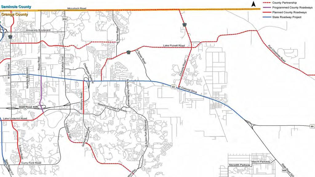
56 Existing Deficiencies Chuluota Road (CR 419) Colonial Drive to Seminole County Line Colonial Drive Avalon Park to Chuluota Road McCulloch Road Lockwood Blvd to North Tanner Road Lake Pickett Road Colonial Drive to Chuluota
 12,423")
")


57 Trip Generation Data* Phase I (2018) 12,423 Daily Trips/708 pm/ph Phase II (2023) 37,847 Daily Trips/2,019 pm/ph Phase III (2030) 67,255 Daily Trips/3,544 pm/ph * Trip generation reflects original development submittal
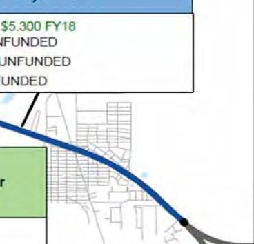


58 SR50 Improvement Schedule 408 $2.000 FY19 (Old Cheney Highway to Chuluota Road)
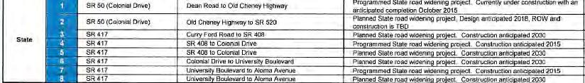
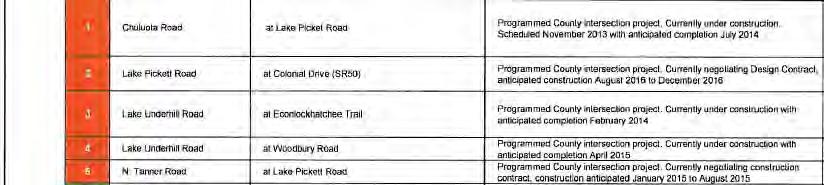
59 Planned/Programmed Projects
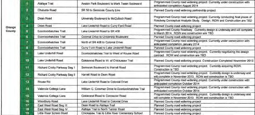
60 Planned/Programmed Projects
61 Phase 1 Impacts
62 Phase 2 Impacts
63 Phase 3 Impacts
")


64 Phase 3(a) Impacts
65 Consistency Consistency with Comprehensive Plan T Requirement to maintain the designated level of service T Improvements based on factors (safety, capacity, row availability, partnerships, located in the urban service boundary, etc. OBJ T2.1 - County will continue to ensure minimum level of service standards on County and state roads T2.21- service T2.2.2 T2.2.3 T2.2.4 T2.2.6 Review the impacts of development in conjunction with issuance of development Proportionate share calculation for projects that degrade LOS Enforce applicable concurrency regulations Mitigation agreement Utilize corridor method of analysis when appropriate

 Global Road Term Sheet Outlines developer(s)")

66 Consistency Transportation Mitigation Options Concurrency/Mitigation within the constraints of HB 7207 & SB 319 Mitigation/proportionate share agreement (limited to addressing project impacts not existing deficiencies) Global Road Term Sheet Outlines developer(s) infrastructure placement tied to development program Commitment to agreements BCC approval of Term Sheet prior to BCC adoption of Comprehensive Plan approval


67 Impact Fee Zones
68
Osceola County Board of County Commissioners 1 Courthouse Square, Suite 1100 Kissimmee, FL
 1/10/11 Item Number DRI08-0006 Osceola County Board of County Commissioners 1 Courthouse Square, Suite 1100 Kissimmee, FL 34741 407-742-0200 Applicant & Owner Center Lake Properties, LLLP and Formally
ORANGE COUNTY IMPLEMENTING THE FOUR C s
 ORANGE COUNTY IMPLEMENTING THE FOUR C s East Central Florida Corridor Task Force O R A N G E COUN TY P LA N N I N G DIVISION C O M M U N I T Y, E N V I R O N M E N T A L A N D D E V E L O P M E N T S E
Dwelling Units Max 12 dwelling units per acre/min 8 dwelling units per acre. Development Mix 80% non residential/20% residential
 13. OSTEEN LOCAL PLAN Background: The Osteen Local Plan area is located in southwest Volusia County along the SR 415 corridor between Lemon Bluff Road and Acorn Lake Road and includes 3,990 acres. The
DOMINION BOULEVARD CORRIDOR STUDY AND ECONOMIC DEVELOPMENT STRATEGIC PLAN A MODEL FOR CHESAPEAKE S FUTURE
 DOMINION BOULEVARD CORRIDOR STUDY AND ECONOMIC DEVELOPMENT STRATEGIC PLAN A MODEL FOR CHESAPEAKE S FUTURE Overview I. Draft Plan Process II. Draft Plan Overview a. Market Analysis b. Master Land Use Plan
ORANGE COUNTY PLANNING DIVISION A-4-4 & C-CP-1 REGULAR AND SMALL SCALE CYCLE AMENDMENTS COMPREHENSIVE PLAN
 ORANGE COUNTY PLANNING DIVISION 24-2-A-4-4 & 24-2-C-CP- REGULAR AND SMALL SCALE CYCLE AMENDMENTS 2-23 COMPREHENSIVE PLAN LOCAL PLANNING AGENCY JULY 8, 24 TRANSMITTAL PUBLIC HEARING PREPARED BY: ORANGE
Baumgarten MPUD. Exhibit 3 Evaluation Criteria
 Pursuant to LDC subsections 10.02.13 B, 10.02.08 F and Chapter 3 G. of the Administrative Code, staff s analysis and recommendation to the Planning Commission, and the Planning Commission s recommendation
Complete Neighbourhood Guidelines Review Tool
 Complete Neighbourhood Guidelines Review Tool Prepared By: City of Regina Planning Department October 2014 Page 1 of 14 Community Development Review Checklist for Secondary Plans and Concept Plans The
ARTICLE 6: Special and Planned Development Districts
 ARTICLE 6: Special and Planned Development Districts 6-10 Traditional Neighborhood Development (TND) District 6-10.10 Purpose and Intent The Traditional Neighborhood Development (TND) District provides
Frequently Asked Questions. What is Sunbridge?
 Frequently Asked Questions What is Sunbridge? Created by Tavistock, Sunbridge is a new, master-planned community in Central Florida. Spanning across 24,000 acres, Sunbridge will feature a variety of housing
AREASTRUCTURE PLAN AMENDMENT COCHRANE NORTH
 AREASTRUCTURE PLAN AMENDMENT COCHRANE NORTH In order to implement the vision outlined in the Conceptual Scheme, the following three amendments to the Cochrane North ASP are proposed: 1. Allow commercial
SUNBRIDGE PARKWAY PRELIMINARY DESIGN STUDY. Board of County Commissioners Public Hearing
 SUNBRIDGE PARKWAY PRELIMINARY DESIGN STUDY Board of County Commissioners Public Hearing March 20, 2018 Presentation Overview Study Overview Existing Conditions Project Development Plan Public Involvement
Staff Report and Recommendation
 Community Planning and Development Planning Services 201 W. Colfax Ave., Dept. 205 Denver, CO 80202 p: 720.865.2915 f: 720.865.3052 www.denvergov.org/cpd TO: City Council Neighborhoods and Planning Committee
2025 COMPREHENSIVE PLAN PASCO COUNTY, FLORIDA
 GOAL FLU 6: PASADENA HILLS FUTURE LAND USE: PASADENA HILLS AREA PLAN GOALS, OBJECTIVES, AND POLICIES PASADENA HILLS AREA PLAN: OVERVIEW The Pasadena Hills Area Plan Goals, Objectives, and Policies are
Applicant Name Phone / Fax / Address City State Zip Code . Property Owner Phone / Fax / Address City State Zip Code
 Master Development Plan Application Community Development Department City of Redmond 411 SW 9 th Street Redmond, Oregon 97756 541-923-7721 541-548-0706 FAX Master Development Plan Fee $38,862.52 File Number
[THIS PAGE INTENTIONALLY LEFT BLANK]
![[THIS PAGE INTENTIONALLY LEFT BLANK]](/thumbs/77/76526040.jpg "[THIS PAGE INTENTIONALLY LEFT BLANK]") 1-1 LAND USE [THIS PAGE INTENTIONALLY LEFT BLANK] TABLE OF CONTENTS INTRODUCTION... 7 1-1. GOAL: TO DEVELOP AND MAINTAIN A WELL-BALANCED COMMUNITY WITH A VARIETY OF LAND USES THAT ARE COMPATIBLE WITH EACH
1-1 LAND USE [THIS PAGE INTENTIONALLY LEFT BLANK] TABLE OF CONTENTS INTRODUCTION... 7 1-1. GOAL: TO DEVELOP AND MAINTAIN A WELL-BALANCED COMMUNITY WITH A VARIETY OF LAND USES THAT ARE COMPATIBLE WITH EACH
Gadsden County Planning Commission Agenda Request
 Date of Meeting: November 16, 2017 To: From: Through: Subject: Gadsden County Planning Commission Agenda Request Honorable Chairperson and Members of the Board Jill A. Jeglie, AICP, Senior Planner Clyde
Citizen Comment Staff Response Staff Recommended Revision Planning Committee
 Citizen Comment Staff Response Staff Recommended Revision Planning Committee Area No. 1: Owner desires retail land uses. Area No. 1a: Owner of two small parcels adjacent to Area No. 1 desires retail land
PRELIMINARY CONDITIONAL USE SUBMITTAL CHECKLIST REQUIREMENTS
 This checklist must accompany your submittal as the cover page. CONDITIONAL USE Application Submittal Checklist for PRELIMINARY AND FINAL APPROVAL Per Winter Park Land Development Code Sec. 58-90 PRELIMINARY
TRANSPORTATION ELEMENT GOALS, OBJECTIVES, AND POLICIES
 TRANSPORTATION ELEMENT GOALS, OBJECTIVES, AND POLICIES GOAL 2 The City shall provide a safe, convenient, effective, and energy efficient multimodal transportation system which is coordinated with the Future
SPECIFIC PLAN Requirements
 CITY OF LANCASTER PLANNING DEPARTMENT 44933 Fern Avenue, Lancaster, California 93534 (661) 723-6100 SPECIFIC PLAN Requirements Purpose The purpose of a specific plan is to provide for the logical development
Planning Commission April 4, 2013 BOCC Workshop Page 1
 Planning Commission April 4, 2013 BOCC Workshop Page 1 Planning Commission April 4, 2013 BOCC Workshop Page 2 Planning Commission April 4, 2013 BOCC Workshop Page 3 Planning Commission April 4, 2013 BOCC
TABLE OF CONTENTS PAGE
 1989 BROWARD COUNTY LAND USE PLAN Original adoption March 1, 1989 Text amendments adopted as of March 10, 2015, are incorporated herein. BROWARD COUNTY BOARD OF COUNTY COMMISSIONERS BROWARD COUNTY PLANNING
1934 Commerce Lane Suite 1 Jupiter, Florida Ph Fax Lic # LC-C ATTACHMENT G.
 Landscape Architects I Land Planners I Environmental Consultants 1934 Commerce Lane Suite 1 Jupiter, Florida 33458 Ph 561.747.6336 Fax 561.747.1377 www.cotleurhearing.com Lic # LC-C000239 ATTACHMENT G
Presentation of the Staff Draft. July 17, 2014 SSRVP Team, Area 3
 Presentation of the Staff Draft July 17, 2014 SSRVP Team, Area 3 Presentation Overview Introduction Plan Framework Plan Recommendations Implementation Next Steps and Request for Public Hearing on September
TREASURE COAST REGIONAL PLANNING COUNCIL M E M O R A N D U M. To: Council Members AGENDA ITEM 5H
 TREASURE COAST REGIONAL PLANNING COUNCIL M E M O R A N D U M To: Council Members AGENDA ITEM 5H From: Date: Subject: Staff October 17, 2008 Council Meeting Local Government Comprehensive Plan Review Draft
CITY OF ROHNERT PARK CITY COUNCIL AGENDA REPORT
 Mission Statement We Care for Our Residents by Working Together to Build a Better Community for Today and Tomorrow. CITY OF ROHNERT PARK CITY COUNCIL AGENDA REPORT ITEM NO. 5 Meeting Date: July 23, 2013
CITY OF PUYALLUP. Background. Development Services
 CITY OF PUYALLUP Development Services 333 South Meridian Puyallup WA 98371 To: City Council From: Katie Baker, AICP, Planning Division Re: South Hill Neighborhood Plan Adoption Date: (Meeting date: February
2025 COMPREHENSIVE PLAN PASCO COUNTY, FLORIDA
 GOAL FLU 6: PASADENA HILLS FUTURE LAND USE: PASADENA HILLS AREA PLAN GOALS, OBJECTIVES, AND POLICIES PASADENA HILLS AREA PLAN: OVERVIEW The Pasadena Hills Area Plan Goals, Objectives, and Policies are
2.7 ac park. TOTAL 5,403 DU 1,297,900 sf 1,105,450 sf 3.87 ac 5,563 DU 1,121,200 sf 1,105,450 sf 3.87 ac
 PLAN AMENDMENT 2013-I-B1: SEVEN CORNERS SPECIAL STUDY Summary of Pre-staffing Comments Planner: Bernard Suchicital bsuchi@fairfaxcounty.gov (703) 324-1254 Background On October 29, 2013, the Board of Supervisors
Intergovermental Coordination
 Intergovermental Coordination CITY OF WINTER PARK CHAPTER 8: INTERGOVERNMENTAL COORDINATION ELEMENT INTERGOVERNMENTAL COORDINATION ELEMENT GOAL 8-1: PROVIDE FOR IMPROVED INTERGOVERNMENTAL COORDINATION
Micco Park Village Development
 FOR SALE Call For Pricing Micco Park Village Development Proposed Project Property Details Micco Park Village Development PRICE Call For Pricing A monumental development opportunity of a lifetime! The
Steering Committee Meeting
 Neighborhood Planning Initiative NPI EAST CENTRAL AREA PLAN Steering Committee Meeting November 9, 2017 6:00PM 8:00PM Tears McFarlane House East Central Area Plan Steering Committee Meeting 11/9/17 AGENDA
3.10 LAND USE SETTING PROJECT SITE EXISTING LAND USE DESIGNATIONS AND ZONING. General Plan Land Use Designations.
 This section of the Draft EIR addresses the existing land uses on and adjacent to the project site and discusses the potential impacts of the proposed project on existing land uses. Key issues addressed
RECREATION AND OPEN SPACE ELEMENT GOALS, OBJECTIVES, AND POLICIES
 RECREATION AND OPEN SPACE ELEMENT GOALS, OBJECTIVES, AND POLICIES Goal 7 To provide park facilities, recreation programs, and open space resources that are safe, adequate, and accessible to all City residents,
2040 LUP is a part of the Comprehensive Plan and carries the same legal authority. Economic Challenges
 1.1. Guiding Anchorage s Growth Where will new residents settle over the next two decades? Where will people work, shop, and play? Will there be enough room to grow? How will Anchorage look? Will growth
REQUEST Current Zoning: O-15(CD) (office) Proposed Zoning: TOD-M(CD) (transit oriented development mixed-use, conditional)
 (office) Proposed Zoning: TOD-M(CD) (transit oriented development mixed-use, conditional)") Rezoning Petition 2016-117 Zoning Committee Recommendation January 4, 2017 REQUEST Current Zoning: O-15(CD) (office) Proposed Zoning: TOD-M(CD) (transit oriented development mixed-use, conditional) LOCATION
Rezoning Petition 2016-117 Zoning Committee Recommendation January 4, 2017 REQUEST Current Zoning: O-15(CD) (office) Proposed Zoning: TOD-M(CD) (transit oriented development mixed-use, conditional) LOCATION
ORANGE COUNTY AT A GLANCE
 ORANGE COUNTY AT A GLANCE Urban Land Institute Technical Advisory Panel Alberto Vargas, MArch Planning Division, Manager ORANGE COUNTY PLANNING DIVISION image credit: Google Earth April 23, 2014 2 Urban
MEMORANDUM AGENDA ITEM #6c
 South Florida Regional Planning Council MEMORANDUM AGENDA ITEM #6c DATE: FEBRUARY 1, 2010 TO: FROM: SUBJECT: COUNCIL MEMBERS STAFF CITY OF PARKLAND PROPOSED COMPREHENSIVE PLAN AMENDMENT (ALTERNATIVE REVIEW)
Atlanta BeltLine Corridor Environmental Study. Scoping Meeting August 2008
 Atlanta BeltLine Corridor Environmental Study Scoping Meeting August 2008 What Will We Be Discussing Today? Study Overview - How Did We Get Here? - What Is the Study About? - Who Is Involved? - Where Is
MIAMI 21 CODE MAY This document is amended as of May 26, 2011.
 CODE MAY 2011 This document is amended as of May 26, 2011. THIS PAGE LEFT INTENTIONALLY BLANK. TABLE OF CONTENTS PREAMBLE ARTICLE 1. DEFINITIONS OF TERMS AND USES 1.1 Definitions of Building Function:
BROOKHILL NEIGHBORHOOD MODEL ZONING MAP AMENDMENT PREFACE TO APPLICATION
 BROOKHILL NEIGHBORHOOD MODEL ZONING MAP AMENDMENT PREFACE TO APPLICATION June 15, 2015 Revised: August 1, 2016 I. VISION Brookhill is a proposed community based upon the principles of Albemarle County
CITY OF TARPON SPRINGS DCA#11-1AR
 Agenda Item #3.H.2 05/09/11 TAMPA BAY REGIONAL PLANNING COUNCIL LOCAL GOVERNMENT COMPREHENSIVE PLAN ADOPTED AMENDMENT REPORT CITY OF TARPON SPRINGS DCA#11-1AR 1 ADOPTED WITH THE FOLLOWING CHANGES: Ordinance
Public may provide comments on the GDP within the next two weeks (December 24)
") 25/70 General Development Plan (GDP) Public Meeting Wednesday, December 10, 2014 6:00 8:00 P.M. District 1 Police Station Community Room 1311 W 46th Ave, Denver, CO 80211 Council Woman Montero: This particular
25/70 General Development Plan (GDP) Public Meeting Wednesday, December 10, 2014 6:00 8:00 P.M. District 1 Police Station Community Room 1311 W 46th Ave, Denver, CO 80211 Council Woman Montero: This particular
City of Woodinville Planning Commission Study Session. Development Regulations 101: An Overview of Specific Regulatory Items To Help You in 2012
 City of Woodinville Planning Commission Study Session Development Regulations 101: An Overview of Specific Regulatory Items To Help You in 2012 Development Regulations 101 Overview of the Different Zones
Review of Opportunity Area C Draft Comprehensive Plan and Draft BOS Follow-On Motions. Special Working Group Meeting March 4, 2015
 Review of Opportunity Area C Draft Comprehensive Plan and Draft BOS Follow-On Motions Special Working Group Meeting March 4, 2015 The slides that follow identify where the draft Comprehensive Plan has
Mitchell Ranch South MPUD Application for Master Planned Unit Development Approval Project Narrative. Introduction
 Mitchell Ranch South MPUD Application for Master Planned Unit Development Approval Project Narrative Introduction Mitchell Ranch South is a proposed single family (detached) residential development on
Narcoossee Roadway Corridor
 Community Meeting Narcoossee Roadway Corridor April 5, 2012 Meeting Agenda Purpose of Meeting Continuation of Study Update Process (Previous Meetings Oct. & Nov., 2011) Tonight s Objective Review Proposals
The scale of intervention:
 The scale of intervention: Degree of specificity Is the TND district linked to a specific site? Is it linked to that site s master plan? If more broadly applicable, how will it relate to a variety of sites
Joint Study Session of the Sutter County. March 2, 2009
 Joint Study Session of the Sutter County Board of Supervisors and Planning Commission March 2, 2009 CURRENT APPLICATION General Plan Amendment Specific Plan Specific Plan Appendices Utility Plans Transit/AQ
PLAN ELEMENTS WORKSHOP. April 5, 2016
 PLAN ELEMENTS WORKSHOP April 5, 2016 needs more housing. But there is no one-size fits-all solution. Every neighborhood has its own character. In some places, density is not only appropriate it is badly
LAND USE ELEMENT. Purpose. General Goals & Policies
 LAND USE ELEMENT Purpose This Land Use Element contains the goals and policies necessary to support the City s responsibility for managing land resources and guiding development through implementing regulations,
Description of Preferred Alternative
 Chapter 2 Description of Preferred Alternative 2.1 Introduction This chapter of the programmatic Sammamish Town Center Sub-area Plan Final EIS provides a more detailed description of the Preferred Alternative
CHUGIAK-EAGLE RIVER SITE-SPECIFIC LAND USE PLAN
 CHUGIAK-EAGLE RIVER SITE-SPECIFIC LAND USE PLAN JUNE 2010 Final Prepared for The Heritage Land Bank, Municipality of Anchorage by Agnew: :Beck Consulting www.agnewbeck.com 907.222.5424 Chugiak-Eagle River
Chapter 10 IMPLEMENTATION RECOMMENDATIONS
 Chapter 10 IMPLEMENTATION RECOMMENDATIONS The recommended land use plan presented in the previous chapter provides a design for the attainment of the urban and rural development and open space preservation
Mixed-Use Trip Reduction Measures (MUTRM) A. Intent and Purpose
 A. Intent and Purpose") CHAPTER 900. SECTION 901. DEVELOPMENT STANDARDS TRANSPORTATION 901.13. Mixed-Use Trip Reduction Measures (MUTRM) A. Intent and Purpose The intent of Mixed Use Trip Reduction Measures (MUTRM) is to promote
CHAPTER 900. SECTION 901. DEVELOPMENT STANDARDS TRANSPORTATION 901.13. Mixed-Use Trip Reduction Measures (MUTRM) A. Intent and Purpose The intent of Mixed Use Trip Reduction Measures (MUTRM) is to promote
VILLAGE OF CLEMMONS PLANNING BOARD DRAFT STAFF REPORT
 VILLAGE OF CLEMMONS PLANNING BOARD DRAFT STAFF REPORT PETITION INFORMATION Docket # C-226 Staff Megan Ledbetter Petitioner(s) JBJH Properties, LLC Owner(s) JBJH Properties, LLC Subject Property 5892-49-1766
Proposed Kenmount Hill CDS Amendment. Public Hearing October 25 th, 2018
 Proposed Kenmount Hill CDS Amendment Public Hearing October 25 th, 2018 History of Kenmount Hill Why Kenmount Hill? Why Now? We are a city with a vision for growth and the development of Kenmount Hill
4. UTILITIES ELEMENT.
 4. UTILITIES ELEMENT. The purpose of this element is to provide for necessary public facilities and services correlated to future land use projections and population demand. Utilities Sub-Elements (A)
Mobility Districts and Traffic Studies
 Mobility Districts and Traffic Studies During the last Comprehensive Plan update in 2008, the City of Sarasota identified the need to develop a citywide strategy for enhancing the mobility options of all
This chapter describes the purpose of the Plan, introduces how the Plan is organized and provides contextual background for the Plan.
 Chapter 1: INTRODUCTION Purpose of a Comprehensive Plan The 2040 Comprehensive Plan establishes Medina s vision as a community and sets goals and objectives which guide future decisions and policies. The
Comprehensive Plan for Unincorporated Hillsborough County Florida
 Future of Hillsborough Comprehensive Plan for Unincorporated Hillsborough County Florida FUTURE LAND USE As Amended by the Hillsborough County Board of County Commissioners June 5, 2008 (Ordinance 08-13)
Municipal Development Plan Update Urban Service Area and Hamlets
 ENCLOSURE 1 Municipal Development Plan Update Urban Service Area and Hamlets Priorities Committee January 24, 2017 MUNICIPAL DEVELOPMENT PLAN UPDATE SHAPING OUR FUTURE MDP Update - Agenda MDP Update Public
LAND USE AMENDMENT CORNERSTONE (WARD 3) 60 STREET NE AND COUNTRY HILLS BOULEVARD NE MAP 26NE BYLAW 22D2017
 60 STREET NE AND COUNTRY HILLS BOULEVARD NE MAP 26NE BYLAW 22D2017") Page 1 of 14 EXECUTIVE SUMMARY This Land Use Amendment application covers an area of 43.76 hectares ± (108.14 acres ±) located in northeast Calgary, bound by Country Hills Boulevard NE to the south and
Page 1 of 14 EXECUTIVE SUMMARY This Land Use Amendment application covers an area of 43.76 hectares ± (108.14 acres ±) located in northeast Calgary, bound by Country Hills Boulevard NE to the south and
PSRC REVIEW REPORT & CERTIFICATION RECOMMENDATION
 PSRC REVIEW REPORT & CERTIFICATION RECOMMENDATION KITSAP COUNTY COUNTYWIDE PLANNING POLICIES July 2, 2012 BACKGROUND A major emphasis of the Washington State Growth Management Act (GMA) is the need to
COLVER ROAD INDUSTRIAL CONCEPT PLAN
 COLVER ROAD INDUSTRIAL CONCEPT PLAN A CONCEPTUAL LAND USE AND TRANSPORTATION PLAN FOR TA-4 AN URBAN RESERVE AREA OF THE CITY TALENT City of Talent Adopted by City Council Resolution No., June, 2015 PART
7,600 Residential Units 1,700,000 SF Non-Res 300-Room ALF 300-Room Hotel University School, Park, Civic parcels 1,889 ac flow-way/preservation
 4,763 ac undeveloped long-term AG use Over 75% characterized by non-native & invasive species Has severely degraded habitat functions 11,565 of frontage along Northlake Blvd. 1,687 of frontage along Beeline
TREASURE COAST REGIONAL PLANNING COUNCIL M E M O R A N D U M. To: Council Members AGENDA ITEM 5I
 TREASURE COAST REGIONAL PLANNING COUNCIL M E M O R A N D U M To: Council Members AGENDA ITEM 5I From: Date: Subject: Staff December 12, 2008 Council Meeting Local Government Comprehensive Plan Review Town
City of Redmond. Urban Holding Area Master Planning Requirements and Approval Process
 City of Redmond Urban Holding Area Master Planning Requirements and Approval Process June 21, 2006 City of Redmond: Urban Holding Area Master Planning Requirements and Approval Process Table of Contents
O l so n M e morial Highway, S t e , G o l d e n V a l l e y, MN Delano Laketown Homes Concept Plan
 N O R T H W E S T A S S O C I A T E D C O N S U L T A N T S, I N C. 4 1 5 0 O l so n M e morial Highway, S t e. 3 2 0, G o l d e n V a l l e y, MN 5 5 4 2 2 T e l e p h o n e : 7 6 3. 9 5 7. 1 1 0 0 W
Secrest Short Cut and Monroe Expressway Small Area Plan AUGUST 29, 2018
 Secrest Short Cut and Monroe Expressway Small Area Plan AUGUST 29, 2018 Background and Process Monroe Expressway will be open by the end of 2018 Union County and Indian Trail identified a need to revisit
E O L A F I V E. Location Map SUMMARY G M P Z O N I T E M S # 1 A. & B.
 N. Eola Drive Staff Report to the Municipal Planning Board August 18, 2015 G M P 2 0 1 5-0 0 0 1 9 Z O N 2 0 1 5-00016 I T E M S # 1 A. & B. A N X 2 0 1 2-0 0 0 0 5 G M P 2 0 1 2-0 0 0 0 6 Z O N 2 0 1
Vision Statement for the Town of Flower Mound Master Plan The Town of Flower Mound Master Plan furthers the established community based vision to:
 Vision Statement for the The furthers the established community based vision to: Preserve the country atmosphere and natural environment that makes Flower Mound a unique and desirable community; Mitigate
S A C R A M E N T O C O U N T Y JACKSON HIGHWAY & GRANT LINE EAST VISIONING STUDY
 JACKSON HIGHWAY & GRANT LINE EAST S A C R A M E N T O C O U N T Y P L A N N I N G D E P A R T M E N T SUMMARY AND WORKBOOK November 19, 2008 History of the Visioning Study Sacramento County has two growth
2035 General Plan Update and Belmont Village Specific Plan. Joint Study Session with the City Council and Planning Commission April 12, 2016
 2035 General Plan Update and Belmont Village Specific Plan Joint Study with the City Council and Planning Commission April 12, 2016 Agenda 1. Welcome and Introductions 2. General Plan Update Status of
CHAPTER 12 IMPLEMENTATION
 CHAPTER 12 IMPLEMENTATION The 2010 Town of Denton Comprehensive Plan is intended to capture a vision of the future of Denton. As such, it provides a basis for a wide variety of public and private actions
VILLAGE OF CLEMMONS PLANNING BOARD DRAFT STAFF REPORT. Single Family Residential, Townhomes
 VILLAGE OF CLEMMONS PLANNING BOARD DRAFT STAFF REPORT PETITION INFORMATION Docket # C-212 Staff Megan Ledbetter Petitioner(s) Peacehaven Development LLC Owner(s) Larry Jarvis, William Alexander and Peacehaven
LAND USE MODEL UPDATE. Planning and Land Use Advisory Committee Meeting #2 September 4, 2014
 1 LAND USE MODEL UPDATE Planning and Land Use Advisory Committee Meeting #2 September 4, 2014 2 Presentation Outline Introduction and Recap Model Process Study Design Place Types Suitability Factors 3
Chapter 1.0 Introduction
 Chapter 1.0 Introduction 1.1 Background The North Metro commuter rail line is part of the RTD FasTracks regional transit system expansion program to build more than 100 miles of rail transit throughout
Future Land Use Element Goals, Objectives & Policies
 Future Land Use Element Goals, Objectives & Policies Future Land Use Element Goals, Objectives, and Policies 163.3177(6)(a) 9J-5.006(3) Overall Goal City of Bunnell Future Land Use Element Ensure that
CONSENT CALENDAR CITY PLANNING COMMISSION AGENDA ITEM NO: A.1, A.2 STAFF: LARRY LARSEN
 Page 8 CONSENT CALENDAR CITY PLANNING COMMISSION AGENDA ITEM NO: A.1, A.2 STAFF: LARRY LARSEN FILE NO: CPC PUZ 14-00013 - QUASI-JUDICIAL FILE NO: CPC PUD 14-00014 QUASI-JUDICIAL PROJECT: APPLICANT: OWNER:
DRAFT Subject to Modifications
 DRAFT Subject to Modifications TREASURE COAST REGIONAL PLANNING COUNCIL M E M O R A N D U M To: Council Members AGENDA ITEM 10 From: Date: Subject: Staff February 19, 2016 Council Meeting Local Government
ALBEMARLE COUNTY CODE CHAPTER 18 ZONING SECTION 20A NEIGHBORHOOD MODEL - NMD
 CHAPTER 18 ZONING SECTION 20A NEIGHBORHOOD MODEL - NMD Sections: 20A.1 PURPOSE AND INTENT 20A.2 STATUS AS A PLANNED DEVELOPMENT DISTRICT 20A.5 CODES OF DEVELOPMENT 20A.6 PERMITTED USES 20A.7 RESIDENTIAL
TABLE OF CONTENTS APPENDIX A PUBLIC WORKSHOP INFORMATION APPENDIX B BUSINESS CENTER TECHNICAL REPORTS APPENDIX C CORRESPONDENCE IN SUPPORT/OPPOSITION
 TABLE OF CONTENTS RCTOD REZONE AMENDMENT DESCRIPTION... 1 MAP SERIES... 2 RESIDENTIAL COMMERCIAL TRANSITION OVERLAY DISTRICT... 7 FINDINGS OF FACT.15 CONCURRENCY SUMMARY REPORT... 16 APPENDIX A PUBLIC
Developer s Program. The Station at East 54
 Developer s Program The Station at East 54 Existing Conditions The Station at East 54 is proposed for a 1.12 acre site at the northeast corner of Hamilton Road and Prestwick Road, tucked between the East
CITY OF CHARLOTTESVILLE, VIRGINIA CITY COUNCIL AGENDA
 CITY OF CHARLOTTESVILLE, VIRGINIA CITY COUNCIL AGENDA Agenda Date: December 16, 2013 Action Required: Adoption of Resolution Presenter: Staff Contacts: Title: James E. Tolbert, AICP, Director of NDS James
MAYFIELD WEST SECONDARY PLAN PHASE 2
 MAYFIELD WEST SECONDARY PLAN PHASE 2 Public Open House #3 February 25, 2010 Draft Preferred Land Use Scenario TOWN OF CALEDON PLANNING & DEVELOPMENT DEPARTMENT Open House Agenda TOWN OF CALEDON 1. Welcome
Department of Community Development. Planning and Environmental Review Division Revised Notice of Preparation
 Department of Community Development Michael J. Penrose, Acting Director Divisions Building Permits & Inspection Code Enforcement County Engineering Economic Development & Marketing Planning & Environmental
SECTION 1 Introduction...1. SECTION 2 Regional Context Criteria for Planning Districts Description of Planning District...
 Table of Contents SECTION 1 Introduction...1 SECTION 2 Regional Context...2 2.1 - Criteria for Planning Districts...2 2.2 - Description of Planning District...2 SECTION 3 Goals & Objectives...5 SECTION
AWH REPORT OF THE PLANNING AND DEVELOPMENT DEPARTMENT FOR APPLICATION FOR REZONING ORDINANCE TO PLANNED UNIT DEVELOPMENT
 AWH REPORT OF THE PLANNING AND DEVELOPMENT DEPARTMENT FOR APPLICATION FOR REZONING ORDINANCE TO PLANNED UNIT DEVELOPMENT MAY 8, 2014 The Planning and Development Department hereby forwards to the Planning
Cobb County Design Guidelines Mableton Parkway & Veterans Memorial Highway Community Design Workshop January 12, 2017
 Community Design Workshop January 12, 2017 Agenda Opening Remarks / Introductions Scope of Work Existing Conditions Key Issues / Opportunities VPS Summary Draft Vision & Goal Statement Implementation Concepts
Selected Area Study. Vision Plan Draft
 East Polk County Selected Area Study Draft 10.30.08 Contents Guiding Principles...4 Context Conclusions...5 Current Context...8 Scenarios...9 Scenario: Status Quo...10 Scenario: Connected & Directed Growth...12
Implementation Guide Comprehensive Plan City of Allen
 Implementation Guide 2030 Comprehensive Plan City of Allen DRAFT 2015 Implementation Guide Allen 2030 Comprehensive Plan INTRODUCTION The Comprehensive Plan serves as a guide for the growth and development
Transit / Housing Oriented Redevelopment
 Broward County Urban Planning and Redevelopment Department Kick-Off Meeting October 24, 2007 Transit / Housing Oriented Redevelopment 1 Future Land Use 2 Broward County Charter Voters approved in 1974.
IMPLEMENTING SOMERSET COUNTY S INVESTMENT FRAMEWORK
 IMPLEMENTING SOMERSET COUNTY S INVESTMENT FRAMEWORK SMART CONSERVATION THROUGH SMART GROWTH NJ LAND CONSERVATION RALLY March 22, 2014 Laurette Kratina, PP, AICP, Supervising Planner Somerset County Planning
Chapter 12 GENERAL STRATEGY
 GOAL: Vision: Section 163.3245, Florida Statutes "supports innovative and flexible planning and development strategies" through the Sector Plan process as a tool to encourage long-term planning for conservation,
ARLINGTON COUNTY, VIRGINIA
 ARLINGTON COUNTY, VIRGINIA County Board Agenda Item Meeting October 15, 2005 DATE: September 28, 2005 SUBJECT: Request to Advertise the adoption of the 2005 Clarendon Sector Plan C. M. RECOMMENDATION:
SUNBRIDGE PARKWAY PRELIMINARY DESIGN STUDY. November 30, 2017
 SUNBRIDGE PARKWAY PRELIMINARY DESIGN STUDY November 30, 2017 Agenda Introductions and Overview Study Purpose Study Approach Key Analysis Components Study Context Existing Conditions Corridor Constraints
14. INTERGOVERNMENTAL COORDINATION ELEMENT
 14. Introduction This Intergovernmental Coordination Element includes Goals, Objectives and Policies (GOP) that apply to the main campus and Alachua County Satellite Properties. The Intergovernmental Coordination
6 Growth Management Challenges and Opportunities
 6 Growth Management Challenges and Opportunities The Town has established a goal of attaining a 50% participation rate with respect to employment opportunities versus residential population. The Town s
CITY OF LANGLEY OFFICIAL COMMUNITY PLAN BYLAW, 2005, NO APPENDIX II - REGIONAL CONTEXT MAP
 CITY OF LANGLEY OFFICIAL COMMUNITY PLAN BYLAW, 2005, NO. 2600 APPENDIX II - REGIONAL CONTEXT MAP ± Legend Agricultural Mixed Employment Industrial Conservation & Recreation Regional City Centre Urban Containment