WASHINGTON COUNTY OREGON
|
|
|
- Bethany Williams
- 5 years ago
- Views:
Transcription
1 WASHINGTON COUNTY OREGON July 9, 2009 Revisions to Chapter 2 of the Bethany Community Plan The North Bethany Subarea Plan Exhibit pages 7 and 8 The sections for the Core and Flexible Streets were amended to: 1. Increase the amount a street alignment may change under a Type II and III development application; and 2. Add the quasi-judicial plan amendment process to propose changes to the land use designations in conjunction with a proposed street alignment change Exhibit pages 10 and New General Design Element 8 was added, which addresses the building setback and landscaping along key Primary Streets. A new map was created to show the street segments addressed by Design Element General Design Element 8, Subsection c) was amended to add the reference to rear yards. (This Design Element is shown as Design Element 9 in the attachment due to the renumbering of the design elements.) 3. The remaining General Design Elements were renumbered to reflect the additional element. Exhibit pages 25 and 26 Arbor Oaks Neighborhood, Design Element 2 1. Subsection c) and c) iv. were amended to state the future street connection to PCC may be from an extension of either Milcliff Street or the east-west street immediately to the south. 2. New Subsection e) was added, which states that rear or side yard orientation of dwellings is permitted along Springville Road. S:\PLNG\WPSHARE\NorthBethanyAdoption\LandUseOrd712\Exhibits\BethanyCP\Cover_summary_Ex2_revisions_ _PC_hrg.doc Department of Land Use & Transportation Planning Division 155 N. First Avenue, Suite , Hillsboro, OR phone: (503) fax: (503)
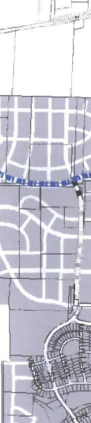
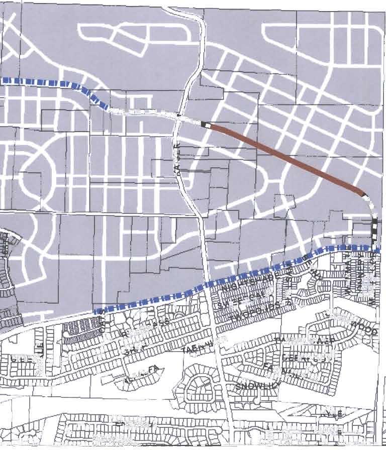
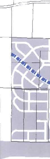
2 C. CORE STREETS AND DESIGN ELEMENTS MAP Page 1 of 6 This map shows streets and design elements that comprise the base template of the Subarea Plan. Core Streets The core streets provide the fundamental framework and basis for the design of and circulation within the Subarea. There are two classes of core streets: Primary and Secondary Streets. The classes of streets are described in the text below. Modifications to the planned alignments of the two classes of streets are permitted through the development review process or through a plan amendment. Table A below identifies the degree to which modifications are allowed through the development review process. A change to land use designations in conjunction with a proposed alignment change is permitted through a quasi-judicial plan amendment as permitted by Policy 1, Implementing Strategy x of the Comprehensive Framework Plan for the Urban Area. Alignment changes through development review and a quasi-judicial plan amendment are limited to the subject site. Alignment changes on another site shall be reviewed through the legislative plan amendment process. a) Primary Streets provide the fundamental framework of the Subarea and are to be constructed per the alignments shown on this map. The design intent for each Primary Street is described in the applicable Neighborhood Design Elements. Most existing streets are Primary Streets that are located within current rights-of-way. These existing streets are incorporated into the planned Primary Street network to improve efficiencies for future development. b) Secondary Streets are the organizational basis for neighborhood design and circulation. These streets make important connections within the North Bethany Subarea and with the surrounding Greater Bethany area. The street alignments, as shown on the Neighborhood Plan maps, are integrally connected with the Landmarks and Focal Points so vistas along the streets terminate at and emphasize these public services and neighborhood amenities. The design intent for each Secondary Street is described in the Neighborhood Plans. Table A: Modifications to the Core and Flexible Street Maps Minor Modification Quasi-judicial Plan Major Modification Type II Development Amendment Type III Development Review Review Primary Streets The planned centerline may move up to twenty-five (25) feet The planned centerline may move more than twenty-five (25) feet Amendments to land use designations may be permitted with alignment change Secondary Streets The planned centerline may move up to fifty (50) feet The planned centerline may move more than fifty (50) feet Amendments to land use designations may be permitted with alignment change Flexible Streets The planned centerline may be moved up to fifty (50) feet The planned centerline may move more than fifty (50) feet; or be eliminated Amendments to land use designations may be permitted with alignment change
3 Page 2 of 6 Core Design Elements Core Design Elements are features that shall be implemented by all development. Noted features include Gateways, Landmarks, the Community Commercial center, and small neighborhood commercial sites. Required Design Elements for these features are found in the respective Neighborhood Plan. D. FLEXIBLE STREETS This map highlights the non-core streets within the Subarea Plan. These flexible streets comprise a third class of street, in addition to the Primary and Secondary streets. Table A identifies the degree of modification allowed through the development review process. The planned centerline of these streets may move up to fifty (50) feet through a Type II development review (minor modification). Major modifications to the street alignment (alignment changes greater than fifty (50) feet or elimination of a street) may be approved through the Type III development review process provided the adjustment meets design elements of the Neighborhood Plan and other applicable standards of this Community Plan and the Community Development Code, such as those related to block length, access spacing, connectivity and sight distance. A change to land use designations in conjunction with a proposed alignment change is permitted through a quasijudicial plan amendment as permitted by Policy 1, Implementing Strategy x of the Comprehensive Framework Plan for the Urban Area. Alignment changes through development review and a quasi-judicial plan amendment are limited to the subject site. Alignment changes on another site shall be reviewed through the legislative plan amendment process.
4 Page 3 of 6 V. NORTH BETHANY SUBAREA DESIGN ELEMENTS All new development shall be consistent with the following design elements and area of special concern requirements. A. GENERAL DESIGN ELEMENTS 1. Floodplains, drainage hazard areas, streams and their tributaries, riparian wooded areas, steep slopes, scenic features, power line easements, and rights-of-way are preserved and protected by being designated with the Public Services-Open Space District. In the design of new development, these areas shall be interconnected with the park and open space system and the storm water and water quality management system consistent with the requirements and standards for CWS and THPRD. 2. Trees located within a Significant Natural Resource Area shall not be removed without first obtaining a development permit for tree removal as provided for within the Community Development Code. A permit shall not be required for tree removal from power line rights-of-way, public parks or playgrounds. 3. Noise reduction measures shall be incorporated into all new residential structures adjacent to arterials and collectors. 4. Pedestrian connections to the rural areas bordering the Subarea shall be provided in order to provide public access to perimeter and regional trails to enjoy the views of the surrounding hills and valleys. Specific design requirements are noted in the applicable Neighborhood Design Elements. 5. New development shall provide for pedestrian/bicycle pathways for public access through or along the development and connect adjacent developments and/or commercial areas, schools, public transit, and park and recreation sites. Outdoor lighting shall be provided along pathways. 6. Off-street trail crossings on arterials and collectors shall be at the locations shown on the Parks, Trails and Pedestrian Connections Map. 7. Residential development shall provide a variety of lot widths, side yard setbacks, building types and street fronting building façades to avoid monotonous streetscapes. 8. Residential development along the following street segments identified on the Residential Minimum Setback map shall meet the setback and landscaping standards described below. In the event there is a conflict between these setbacks standards and the setback standard of the primary district, this Plan shall control. a) Road A, between the UGB and Primary Street P9: i) Minimum setback: twenty (20) feet; and ii) Provide an additional row of street trees consistent with the standards of CDC Section to provide additional buffering and visual interest. b) Springville Road, between Oats Terrace and the UGB: i) Minimum setback: twenty (20) feet
5 Page 4 of 6 ii) Provide an additional row of street trees consistent with the standards of CDC Section to provide additional buffering and visual interest. c) Joss Road, between P8 and Road A: i) Minimum setback: fifteen (15) feet ii) The additional setback shall be landscaped with a combination of trees, shrubs and / or groundcovers. d) Southern side of Road, A between P9 and the Springville Road: i) Minimum setback: fifteen (15) feet ii) The additional setback shall be landscaped with a combination of trees, shrubs and / or groundcovers. e) Northern side of Road A between S20 and S17 where Road A parallels the linear park: i) Along the linear park the minimum setback may be reduced to five (5) feet. 9. The front façades of buildings shall be oriented toward public spaces (e.g., streets, commercial areas, civic areas, natural resources, trails, parks, and schools), except as provided by a) through d) below. The Building Orientation and Orientation symbols on the Neighborhood Plan maps indicate where front or side building façades shall face public spaces. Conditions where side building façades are permitted: a) The lot is adjacent to a powerline corridor Side yards and side building façades may be provided for residential uses adjacent to a powerline corridor; rear yards and rear building façades shall not be adjacent to these open spaces; b) The lot is adjacent to a Primary or Secondary Street The front yard and the front building façade of residential buildings along these streets shall front these streets. Where this orientation is not practicable, side yards and side building façades may front the street provided no more than twenty-five percent (25) of the lots and buildings have a side orientation on each individual street. Side building façades shall include windows and other architectural features to prevent blank façades; c) A Neighborhood Design Element allows a side or rear yard and/or a side or rear building façade to front onto the public space; and d) For courtyard housing fronting a common private open space, the building frontage design element will be satisfied when the open space area is directly connected to the adjacent street or other adjacent public space. 10. Buildings that are identified on a Neighborhood Plan map as a Landmark shall be located on the site to make the building visible from the neighborhood as indicated by the Orientation arrows on the respective Neighborhood Plan map. Landmark buildings shall be designed and located to provide a terminated vista for the sight lines shown on the Neighborhood Plan maps. 11. New development shall dedicate right-of-way for new streets and extensions and alignments of existing streets as indicated on Washington County s Transportation Plan. New development shall also be subject to conditions set forth in the North Bethany growth management policy during development review.
6 Page 5 of Access points shall be provided as indicated on the Neighborhood Plan maps and consistent with the Core Streets Map and any applicable Areas of Special Concern. 13. Access onto arterials and collectors shall be limited, which in some cases will require developments to have shared/consolidated access points to these streets. Access points to these streets shall be limited to the locations shown on the Core Street and Design Elements map, subject to compliance with the applicable ASC Road Corridors and county sight distance and access spacing requirements. 14. Streets shall be constructed consistent with the Street Cross Sections, as depicted on the Street Design Plan. Street Cross Sections are included in Section VII. 15. New development shall provide street trees consistent with the Street Design Plan. Street tree tables are included in Section VII. 16. New development shall be consistent with the North Bethany Drainage Master Plan. 17. New development located in a potential landslide hazard area shall comply with any applicable requirements of the Community Development Code and Chapter 14.2 of the Washington County Code. 18. Residential development with curbside mail delivery shall provide centralized or grouped mail boxes that are available prior to the occupancy of dwellings. 19. New development shall provide pedestrian scale street lighting along all streets consistent with county standards. A uniform luminaire pole and arm shall be used in each North Bethany Neighborhood. 20. The exterior lighting of new development shall be dark sky friendly per standards in the Community Development Code. 21. Where a plaza is required to be provided, vehicular use of the plaza is prohibited.
7 F. ARBOR OAKS NEIGHBORHOOD Page 6 of 6 *** 2. In addition to Design Element 1 above, future phases of development shall comply with the following design elements: a) The Waterhouse Trail runs through North Bethany along the north-south powerline corridor. It is important for trail users to have reasonable access to the trail. Pedestrianbicycle access points shall be provided at regular intervals along the trail, generally spaced at 330 feet or less. Sidewalks along street crossings count toward this access requirement. The sidewalks of local street crossings may count toward this access requirement. b) Joss Road is identified as an Area of Special Concern. Access and design shall be in accordance with ASC Road Corridor C3. c) A future street connection shall be provided between PCC and the Arbor Oaks neighborhood. The connection shall be via an extension of either Milcliff Street (S1) or the east-west street immediately south of S1. The extension shall connect into the College Neighborhood just north of the Rock Creek Sports Center upon redevelopment of the PCC campus. In general, streets and pedestrian accessways from this area shall stub to the PCC campus to provide the opportunity for future street connections and improved bike and pedestrian connections. d) The Arbor Oaks Neighborhood has three Primary Streets and two Secondary Streets. These streets shall be provided in new development consistent with Section IV.D (Core Streets and Design Elements) and Section V.B (Areas of Special Concern) of the North Bethany Subarea Plan. The intent of the streets is provided below: i. Joss Road is an existing north-south Primary Street. ii. Rossetta Street (P2) is an existing Primary Street that shall extend east from Joss Road to Kaiser Road and then to Road A. iii. North of the elementary school, Primary Street P8 extends west from Joss Road and goes north before the PCC property. The road intersections with Primary Street P1 and is the eastern border of the neighborhood park in the West Neighborhood. iv. Secondary Street S1 shall be a future connection between Arbor Oaks and PCC campus upon further redevelopment of the campus. The street alignment shall be either an extension of the existing Milcliff Street to the west or the east-west street shown as a stub street to PCC on the Arbor Oaks Revised Master Plan. v. Secondary Street S2 extends north from Rossetta Street to intersect with the existing Brugger alignment just east of the West Community Park. e) Side and rear lot orientation to Springville Road is permitted. 3. Development shall be consistent with Areas of Special Concern Road Corridor 3, 4A and 4B.

8
North Bethany Subarea Plan
 North Bethany Subarea Plan Washington County A-Engrossed Land Use Ordinance No. 739 9/28/2011 September 30, 2011 Page 2 require the Vegetation Buffer with Fencing along the eastern perimeter to put the
ARTICLE 13 STREETS General
 ARTICLE 13 STREETS 13.1 General Streets shall be designed to suit their functions. Many streets have purposes other than vehicular traffic. As an alternative to current N.C. Department of Transportation
ARTICLE 13 STREETS General
 ARTICLE 13 STREETS 13.1 General Streets shall be designed to suit their functions. Many streets have purposes other than vehicular traffic. As an alternative to current N.C. Department of Transportation
ATTACHMENT A. SILVERDALE DESIGN STANDARDS Amendments to the Waaga Way Town Center Chapter
 ATTACHMENT A SILVERDALE DESIGN STANDARDS Amendments to the Waaga Way Town Center Chapter Chapter 10. Waaga Way Town Center 10.1 Physical Identity Elements & Opportunities The Waaga Way Town Center includes
EXHIBIT A. Chapter 2.7 SPECIAL PLANNED DISTRICTS. Article XVIII 15th Street School Master Planned Development
 EXHIBIT A Chapter 2.7 SPECIAL PLANNED DISTRICTS Article XVIII 15th Street School Master Planned Development Sections: 2.7.3600 15 th Street School Master Planned Development 2.7.3610 Purpose 2.7.3620 Definitions
ARTICLE IV: DEVELOPMENT STANDARDS 404 MASTER PLANNING
 IV 13 404 MASTER PLANNING Master Planning through the Site Analysis (Master Planning Site Analysis) or Planned Development (Master Planning Planned Development) is provided to encourage development which
POLICY 41, URBAN GROWTH BOUNDARY EXPANSIONS:
 POLICY 41, URBAN GROWTH BOUNDARY EXPANSIONS: It is the policy of Washington County to ensure an efficient and effective transition of rural land to urban development when an Urban Growth Boundary (UGB)
WASHINGTON COUNTY OREGON
 WASHINGTON COUNTY OREGON LONG RANGE PLANNING DIVISION North Bethany Subarea Stream Corridors: Existing Regulations In Oregon, there is a distinct difference between the land use rules that apply in rural
DRAFT Northeast Quadrant of Kipling Avenue and Highway 7 DRAFT AUGUST 29, Goals Land Use. The goals of this Plan are to:
 AUGUST 29, 2017 12.15 Northeast Quadrant of Kipling Avenue and Highway 7 12.15.1 Goals 12.15.2 Land Use The goals of this Plan are to: 12.15.2.1 General Provisions: a) Ensure the development of a compact
NORTH BETHANY ELEMENTARY SCHOOL SITE ASSESSMENT
 NORTH BETHANY ELEMENTARY SCHOOL SITE ASSESSMENT Prepared for: Prepared by: October 10, 2014 Page 2 Introduction and Purpose This report provides an assessment of two potential sites for a new elementary
ARTICLE 6: Special and Planned Development Districts
 ARTICLE 6: Special and Planned Development Districts 6-10 Traditional Neighborhood Development (TND) District 6-10.10 Purpose and Intent The Traditional Neighborhood Development (TND) District provides
B. Blocks, Buildings and Street Networks
 B. Blocks, Buildings and Street Networks Figure IV.4 A rational block pattern with connected streets Introduction The single most important element in the physical and functional integration of mixed use
REQUEST Current Zoning: O-15(CD) (office) Proposed Zoning: TOD-M(CD) (transit oriented development mixed-use, conditional)
 (office) Proposed Zoning: TOD-M(CD) (transit oriented development mixed-use, conditional)") Rezoning Petition 2016-117 Zoning Committee Recommendation January 4, 2017 REQUEST Current Zoning: O-15(CD) (office) Proposed Zoning: TOD-M(CD) (transit oriented development mixed-use, conditional) LOCATION
Rezoning Petition 2016-117 Zoning Committee Recommendation January 4, 2017 REQUEST Current Zoning: O-15(CD) (office) Proposed Zoning: TOD-M(CD) (transit oriented development mixed-use, conditional) LOCATION
CONTENTS 8.0 LAND USE 8.1 GENERAL LAND USE 8.2 RESIDENTIAL 8.3 MIXED USE 8.4 COMMERCIAL 8.5 EMPLOYMENT LANDS
 8-2 Land Use 8.0 LAND USE CONTENTS 8.1 GENERAL LAND USE 8.1.1 Uses provided for in all Land Use Designations 8.1.2 Uses prohibited in Hazardous Lands, Hazardous Sites and Special Policy Areas 8.1.3 Uses
Chapter PEDESTRIAN COMMERCIAL (PC) ZONING DISTRICT
 ZONING DISTRICT") Chapter 11-17 PEDESTRIAN COMMERCIAL (PC) ZONING DISTRICT Sections: 11-17-01 GENERAL PURPOSE 11-17-02 PERMITTED BUILDING TYPES 11-17-03 USES PERMITTED WITH DESIGN REVIEW 11-17-04 USES PERMITTED BY CONDITIONAL
Chapter 11-17 PEDESTRIAN COMMERCIAL (PC) ZONING DISTRICT Sections: 11-17-01 GENERAL PURPOSE 11-17-02 PERMITTED BUILDING TYPES 11-17-03 USES PERMITTED WITH DESIGN REVIEW 11-17-04 USES PERMITTED BY CONDITIONAL
CHAPTER 3. Design Standards for Business, Commercial, Industrial, Recreational and Institutional Uses
 CHAPTER 3 Design Standards for Business, Commercial, Section Number Title Ordinance Number Date of Ordinance 16-3-1 Applicability 2006-11 2008-04 07-01-08 16-3-2 Uniform Standards for Architectural Design
PROPOSED BLOCK LENGTH CODE AMENDMENT
 10.426 Street Circulation Design and Connectivity. These standards are intended to assure that development will ultimately result in complete blocks bound by a network of public streets, and/or private
ARTICLE II CITYWIDE REGULATIONS
 ARTICLE II CITYWIDE REGULATIONS RZC 21.24 FENCES Fences User Guide 21.24.010 Purpose The purpose of this chapter is to provide for fences that: A. Protect or enhance property and life and that are compatible
COMMUNITY DESIGN. GOAL: Create livable and attractive communities. Intent
 COMMUNITY DESIGN Intent An attractive, well-designed County will attract quality development, instill civic pride, improve the visual character of the community, and create a strong, positive image for
BROOKHILL NEIGHBORHOOD MODEL ZONING MAP AMENDMENT PREFACE TO APPLICATION
 BROOKHILL NEIGHBORHOOD MODEL ZONING MAP AMENDMENT PREFACE TO APPLICATION June 15, 2015 Revised: August 1, 2016 I. VISION Brookhill is a proposed community based upon the principles of Albemarle County
North Oakville East Parks Facilities Distribution Plan. November, 2009
 North Oakville East November, 2009 POLICY CONTEXT 1) Purpose a) The purpose of this document is to be a guide for the location, configuration, design and development of the parks system for the North Oakville
and services The protection and conservation of environmentally significant and sensitive natural heritage features and functions.
 6. Land Use 6.0 Preamble A healthy and livable city is one in which people can enjoy a vibrant economy and a sustainable healthy environment in safe, caring and diverse neighbourhoods. In order to ensure
VILLAGE OF SKOKIE Design Guidelines for Mixed-Use Districts NX Neighborhood Mixed-Use TX Transit Mixed-Use CX Core Mixed-Use
 VILLAGE OF SKOKIE Design Guidelines for Mixed-Use Districts NX Neighborhood Mixed-Use TX Transit Mixed-Use CX Core Mixed-Use TABLE OF CONTENTS CHAPTER 1 SITE DESIGN Purpose 1 CHAPTER 2 SITE DESIGN Streetscape
4.500 Preston Road Overlay District
 Section 4.500 Preston Road Overlay District 2004 Zoning Ordinance 4.500 Preston Road Overlay District (ZC 98-29; Ordinance No. 98-9-12) 4.501 Purpose To provide appropriate design standards for the use
URBAN DESIGN BRIEF URBAN DESIGN BRIEF 721 FRANKLIN BLVD, CAMBRIDGE August 2018
 URBAN DESIGN BRIEF URBAN DESIGN BRIEF 721 FRANKLIN BLVD, CAMBRIDGE August 2018 DESIGN BRIEF CONTENTS PART A 1.0 INTRODUCTION 2.0 DESCRIPTION & ANALYSIS OF SITE CONTEXT 3.0 DESIGN CONSTRAINTS AND OPPORTUNITIES
Standards (R-3) Figure B-11: R-3 Residential Standards Exhibit
 Figure B-11: R-3 Residential Standards Exhibit") Avila Ranch Avila Ranch Specific Plan Development Standards High Medium Density - High Residential Density Residential Lot and Building Lot and Standards Building (R-3) Standards (R-3) EXAMPLES These sketches
Avila Ranch Avila Ranch Specific Plan Development Standards High Medium Density - High Residential Density Residential Lot and Building Lot and Standards Building (R-3) Standards (R-3) EXAMPLES These sketches
Chapter 5: Natural Resources and Environment
 NATURAL RESOURCES AND ENVIRONMENT 5-1 5 Chapter 5: Natural Resources and Environment BACKGROUND AND INTENT Urban expansion represents the greatest risk for the future degradation of existing natural areas,
ARTICLE 3 LANDSCAPING AND SCREENING REQUIREMENTS
 ARTICLE 3 CHAPTER 4 LANDSCAPING AND SCREENING REQUIREMENTS SEC 3.401 SEC 3.402 (D) (E) PURPOSE: The purpose of this Chapter is to establish minimum standards for the design, installation, and maintenance
Town Center. Block 5 Existing multifamily residential units are expected to remain.
 Area Guidelines Germantown s districts should be developed as distinct communities with unique features that are supported through the guidelines. The guidelines not only help distinguish these districts
KEIZER STATION PLAN INTRODUCTION
 KEIZER STATION PLAN INTRODUCTION Planning for this area began in 1987 when the Keizer Comprehensive Plan established the Chemawa Activity Center and McNary Activity Center. The first Chemawa Activity Center
EXHIBIT B PROJECT NARRATIVE POULSBO MEADOWS
 EXHIBIT B PROJECT NARRATIVE POULSBO MEADOWS Name of Project: Poulsbo Meadows; A Planned Residential Development (PRD)/Plat Applicants Name: PBH Group LLC/Byron Harris PO Box 1010 Silverdale, WA 98038 Description
5.1.1 The streetscape along US Highway 64 (Brevard Road); and, The built environment within new residential developments; and,
; and, The built environment within new residential developments; and,") Article 5. Landscaping 5.1 Purpose The Town of Laurel Park s landscape standards are designed to create a beautiful, aesthetically pleasing built environment that will complement and enhance community
Article 5. Landscaping 5.1 Purpose The Town of Laurel Park s landscape standards are designed to create a beautiful, aesthetically pleasing built environment that will complement and enhance community
Division 9 Southwood Ranch (CR 484/475/475A Corridor-Gateway Development Overlay) Purpose and Intent Applicability.
 Purpose and Intent Applicability.") Division 9 Southwood Ranch (CR 484/475/475A Corridor-Gateway Development Overlay) 5.9.1 Purpose and Intent. The Southwood Ranch Overlay is intended to be a mixed use community with commercial and residential
Division 9 Southwood Ranch (CR 484/475/475A Corridor-Gateway Development Overlay) 5.9.1 Purpose and Intent. The Southwood Ranch Overlay is intended to be a mixed use community with commercial and residential
MIDTOWN MIXED-USE VILLAGE. TECHNICAL DATA SHEET COMPONENT C-1 FOR PUBLIC HEARING - PETITION NUMBER Project No RZ1.1. Issued.
 N MIDTOWN MIXED-USE VILLAGE TECHNICAL DATA SHEET COMPONENT C- FOR PUBLIC HEARING - PETITION NUMBER 04-00 Project No. 496 Issued Revised SCALE: " = 0' N 0 0 0 40 RZ. c GENERAL PROVISIONS: a. SITE LOCATION.
11.4 Highway 400 North Employment Lands Secondary Plan APPROVED BY THE ONTARIO MUNICIPAL BOARD ON NOVEMBER 21, 2011
 11.4 Highway 400 North Employment Lands Secondary Plan APPROVED BY THE ONTARIO MUNICIPAL BOARD ON NOVEMBER 21, 2011 11.4.1 General 11.4.1.1. as approved by the Ontario Municipal Board on November 21, 2011,
Corridor Identity. Section 9. Introduction. Corridor Guiding Principles
 Corridor Identity An attractive and healthy community is a critical element of a quality place, and the design of quality places is a balance between environmental, economic, and social considerations.
Eastcreek Farm. Planned Development Standards September, 2014
 Eastcreek Farm Planned Development Standards September, 2014 ekfarm Contents 01. General Standards 02. Residential Development Standards 03. Architectural Design Standards 04. Landscape Design Standards
Community Design Plan
 Gardena General Plan 2006 Authority While the is not a required element of a General Plan, it is included because improving the community appearance and image is paramount to the overall quality of life
PUBLIC RIGHT-OF-WAY IN THIS CHAPTER PUBLIC REALM
 PUBLIC RIGHT-OF-WAY This section provides design guidelines for improvements in the public right-of-way. The public right-of-way refers to streets, sidewalks, non-vehicular thoroughfares, parks and greenways
CHAPTER FIVE COMMUNITY DESIGN
 CHAPTER FIVE COMMUNITY DESIGN CHAPTER FIVE - COMMUNITY DESIGN Assumptions Frazier Park and Lebec have historically developed according to different patterns of spatial form. While both communities are
SYRINGA VALLEY SPECIFIC PLAN NARRATIVE
 SYRINGA VALLEY SPECIFIC PLAN NARRATIVE Introduction With this application, Pleasant Valley South LLC ( Pleasant Valley ) seeks the City of Boise s approval of a new Specific Plan Ordinance to be added
ORDINANCE AN ORDINANCE TO ADD A NEW SECTION 4.N. IN THE ZONING CODE FOR THE TOWN OF MIDDLETOWN, RELATING TO MIXED-USE DEVELOPMENT
 Introduced: November 5, 2018 Approved: ORDINANCE 18-11-01 AN ORDINANCE TO ADD A NEW SECTION 4.N. IN THE ZONING CODE FOR THE TOWN OF MIDDLETOWN, RELATING TO MIXED-USE DEVELOPMENT BE IT ENACTED BY THE MAYOR
2.0 AREA PLANS. Lakeside Business District. Lakeside Business District Land Use Categories:
 Lakeside Business District Lakeside Business District Land Use Categories: Campus Commercial Campus Commercial means a mixture of uses which includes corporate offices, office parks, hotels, commercial,
CITY PLANNING COMMISSION AGENDA ITEM: C STAFF: ROBERT TEGLER FILE NO: CPC PUD QUASI-JUDICIAL
 CPC AGENDA June 8, 2006 Page 37 CITY PLANNING COMMISSION AGENDA ITEM: C STAFF: ROBERT TEGLER FILE NO: CPC PUD 05-294 - QUASI-JUDICIAL PROJECT: APPLICANT: OWNER: PARKWOOD AT WOLF RANCH NASS DESIGN ASSOCIATES
Seneca Meadows. Block 4 Locate office, technology, and medical development adjacent to I Screen views of garage structures from I-270.
 Seneca Meadows Seneca Meadows has an industrial park in its southern end and a mixed-use employment area planned for the north end. The district benefits from extensive I-270 visibility, stream valley
Section 9 NEIGHBORHOOD DESIGN
 Section 9 NEIGHBORHOOD DESIGN City of Lancaster Comprehensive Plan D u n k i n, S e f k o & A s s o c i a t e s, I n c. NEIGHBORHOOD DESIGN INTRODUCTION There are many ways in which a neighborhood can
FREEWAY/TOURIST DISTRICT
 FREEWAY/TOURIST DISTRICT DESIGN STANDARDS FOR THE CITY OF MOUNTLAKE TERRACE March, 2014 MOUNTLAKE TERRACE FREEWAY/TOURIST DESIGN STANDARDS March, 2014 1 TABLE OF CONTENTS Introduction...1 Design Site Design
FORMER CANADIAN FORCES BASE (CFB) ROCKCLIFFE SECONDARY PLAN. Official Plan Amendment XX to the Official Plan for the City of Ottawa
 ROCKCLIFFE SECONDARY PLAN. Official Plan Amendment XX to the Official Plan for the City of Ottawa") FORMER CANADIAN FORCES BASE (CFB) ROCKCLIFFE SECONDARY PLAN Official Plan Amendment XX to the Official Plan for the City of Ottawa 1 INDEX THE STATEMENT OF COMPONENTS PART A THE PREAMBLE PAGE Purpose...
FORMER CANADIAN FORCES BASE (CFB) ROCKCLIFFE SECONDARY PLAN Official Plan Amendment XX to the Official Plan for the City of Ottawa 1 INDEX THE STATEMENT OF COMPONENTS PART A THE PREAMBLE PAGE Purpose...
KASPER. City of Georgetown, Texas PUD Planned Unit Development. December 30, 2015 Revised January 27, 2016
 KASPER City of Georgetown, Texas PUD Planned Unit Development December 30, 2015 Revised January 27, 2016 Applicant: Sentinel Land Company, LLC 4910 Campus Drive Newport Beach, CA Prepared by: SEC Planning
Complete Neighbourhood Guidelines Review Tool
 Complete Neighbourhood Guidelines Review Tool Prepared By: City of Regina Planning Department October 2014 Page 1 of 14 Community Development Review Checklist for Secondary Plans and Concept Plans The
Ten Mile Creek Planning Area
 PLANNING AREA POLICIES TEN MILE CREEK Ten Mile Creek Planning Area Location and Context The Ten Mile Creek Planning Area ( Ten Mile Creek area ) is located south of the current Boise AOCI, generally south
4 C OMMUNITY D ISTRICTS
 4 C OMMUNITY D ISTRICTS N ew development in the Area will include many different types of land uses, including a destination retail area that attracts people from all over the region; recreation opportunities
CITY PLANNING COMMISSION AGENDA. ITEM NO: 6.a 6.b STAFF: LONNA THELEN
 Page 156 CITY PLANNING COMMISSION AGENDA ITEM NO: 6.a 6.b STAFF: LONNA THELEN FILE NO(S): A. - CPC ZC 08-00069 QUASI-JUDICIAL B. - CPC CU 08-00070 QUASI-JUDICIAL PROJECT: APPLICANT: OWNER: PHIL LONG VALUCAR
RZC Public View Corridors and Gateways
 RZC 21.42 Public View Corridors and Gateways 21.42.010 Purpose 21.42.020 Scope and Authority 21.42.030 Administration 21.42.040 Gateways Design 21.42.050 Unidentified Public Views 21.42.060 Identification
Urban Design Brief Proposed Residential Development 5219 Upper Middle Road City of Burlington
 Urban Design Brief Proposed Residential Development 5219 Upper Middle Road City of Burlington Prepared by Weston Consulting Prepared for BLOOMFIELD DEVELOPMENT INC. Date: March 2017 Table of Contents 1.
COUNTY COUNCIL OF PRINCE GEORGE'S COUNTY, MARYLAND SITTING AS THE DISTRICT COUNCIL 2010 Legislative Session. Council Members Dernoga and Olson
 DR- COUNTY COUNCIL OF PRINCE GEORGE'S COUNTY, MARYLAND SITTING AS THE DISTRICT COUNCIL 00 Legislative Session Bill No. CB--00 Chapter No. Proposed and Presented by Introduced by Co-Sponsors The Chairman
North Bethany Subarea Plan: An Overview
 North Bethany Subarea Plan: An Overview The North Bethany Subarea Plan (Plan) was adopted by Washington County in 2010. The adopted Plan identifies key elements that are shown on the next posters. These
Exhibit A. 8:9 Scuffletown Rural Conservation District
 Exhibit A 8:9 Scuffletown Rural Conservation District 8:9.1 Intent and Purpose The Scuffletown Rural Conservation (SRC) District is intended to provide for residential development that supports the development
BE IT ORDAINED by the Board of Supervisors of Chesterfield County:
 Attachment A AN ORDINANCE TO AMEND THE CODE OF THE COUNTY OF CHESTERFIELD, 1997, AS AMENDED, BY AMENDING AND REENACTING SECTIONS 19.1-52, 19.1-53, 19.1-236, 19.1-247, 19.1-253, 19.1-263, 19.1-341, 19.1-346,
OCEAN BOULEVARD PLANNED DEVELOPMENT DISTRICT (PD-5)
") OCEAN BOULEVARD PLANNED DEVELOPMENT DISTRICT (PD-5) Ordinance History: C-5562, 1982 The intent of the Planned Development Plan is to provide a framework to guide new development in a way that is sensitive
OCEAN BOULEVARD PLANNED DEVELOPMENT DISTRICT (PD-5) Ordinance History: C-5562, 1982 The intent of the Planned Development Plan is to provide a framework to guide new development in a way that is sensitive
GUIDING PRINCIPLES IN THIS CHAPTER
 GUIDING PRINCIPLES The guiding principles and design concepts in this chapter work together with the Chapel Hill 2020 Comprehensive Plan to support new public places that can be enjoyed by all while also
VEHICULAR AND PEDESTRIAN CIRCULATION
 This perspective sketch communicates the intended character and quality of a proposed streetscape design. Locate benches near a major intersection where people tend to gather. Seating and lighting provide
II. SINGLE FAMILY RESIDENTIAL
 II. SINGLE FAMILY RESIDENTIAL Castle Rock is made up of numerous individually built houses and subdivision tracts that have been developed during the past century. Some of the tracts are diverse in architectural
ARTICLE 9: Landscaping
 ARTICLE 9: Landscaping 9-10 Legislative Intent The purpose of this Article is to regulate the planting and preservation of landscape materials; to facilitate the creation of an attractive and healthy environment;
City of Redmond. Urban Holding Area Master Planning Requirements and Approval Process
 City of Redmond Urban Holding Area Master Planning Requirements and Approval Process June 21, 2006 City of Redmond: Urban Holding Area Master Planning Requirements and Approval Process Table of Contents
AWH REPORT OF THE PLANNING AND DEVELOPMENT DEPARTMENT FOR APPLICATION FOR REZONING ORDINANCE TO PLANNED UNIT DEVELOPMENT
 AWH REPORT OF THE PLANNING AND DEVELOPMENT DEPARTMENT FOR APPLICATION FOR REZONING ORDINANCE TO PLANNED UNIT DEVELOPMENT MAY 8, 2014 The Planning and Development Department hereby forwards to the Planning
DEVELOPMENT CONTROLS MEDICAL DISTRICT
 6.01. GENERAL DESIGN GUIDELINES A. Site Planning B. Architectural Design C. Medical Facility Signage & Lighting D. Exhibit 48. ARCHITECTURAL DESIGN CONCEPTS 6.02. MEDICAL FACILITY STANDARDS & GUIDELINES
DEVELOPMENT FRAMEWORK POST 2030 LAND USE PLAN INTRODUCTION
 INTRODUCTION Oak Grove s Comprehensive Plan identifies a future Metropolitan Urban Service Area (MUSA). The Metropolitan Council does not anticipate extending utilities to this area prior to 2030. The
MIXED-USE VILLAGE OVERLAY FLOATING DISTRICT
 MIXED-USE VILLAGE OVERLAY FLOATING DISTRICT Zoning regulations developed by committee to the Planning Board for the Town of DeWitt, NY Issue date: 13 July 2017 revised 3/12/2018, revised 4/26/2018, 5/9/2018
DESIGN AND LANDSCAPE GUIDELINES FOR DEVELOPMENT
 DESIGN AND LANDSCAPE GUIDELINES FOR DEVELOPMENT IN THE SECOND SUPERVISORIAL DISTRICT (REVISED) ADOPTED BY RIVERSIDE COUNTY BOARD OF SUPERVISORS ON SEPTEMBER 15, 1998 REVISED OCTOBER 23, 1998 REVISED AUGUST
Planning Board Briefing
 Planning Board Briefing Why Now? The Sector Plan Implementation Chapter States: Before Stage 1 begins, the following must occur: Approval of the Sectional Map Amendment. Approval of the Greater Lyttonsville
11.4 Highway 400 North Employment Lands Secondary Plan
 11.4 Highway 400 North Employment Lands Secondary Plan APPROVED BY THE ONTARIO MUNICIPAL BOARD ON NOVEMBER 21, 2011 11.4.1 General 11.4.1.1. The following policies and Schedules A - I form Official Plan
ARTICLE XXXIII (O) OJUS URBAN AREA DISTRICT
 OJUS URBAN AREA DISTRICT") Page 1 ARTICLE XXXIII (O) OJUS URBAN AREA DISTRICT Sec. 33-284.99.14 Purpose, intent and applicability. A. The regulations contained in this chapter and Chapter 18A, Landscape Code, Code of Miami-Dade
Page 1 ARTICLE XXXIII (O) OJUS URBAN AREA DISTRICT Sec. 33-284.99.14 Purpose, intent and applicability. A. The regulations contained in this chapter and Chapter 18A, Landscape Code, Code of Miami-Dade
OPEN SPACE TYPES. SIZE 8 acres. SIZE 20 acres. SIZE 1 acre
 TYPICAL CHARACTERISTICS OPEN SPACE TYPES OPEN SPACE TYPES The neighborhood contains an extensive variety of open space types. Most of these spaces incorporate multiple uses and activities, so that each
I. Introduction. Prior Approvals
 Statement of Justification First National Bank 19790 Crystal Rock Drive, Germantown, Maryland Application for Site Plan and Limited Preliminary Plan Amendment I. Introduction DPH Architecture, for First
3. VISION AND GOALS. Vision Statement. Goals, Objectives and Policies
 Vision Statement Queen Creek s interconnected network of parks, trails, open spaces and recreation opportunities provide safe and diverse activities and programs that sustain its unique, small town, equestrian
Regency Developments. Urban Design Brief. Holyrood DC2 Rezoning
 Regency Developments Urban Design Brief Holyrood DC2 Rezoning Stantec Consulting Ltd. 7-31-2017 1. Overview Regency Developments intends to rezone the lands located at 8510 and 8511 93 Avenue, within the
4. INDUSTRIAL 53 CASTLE ROCK DESIGN
 4. INDUSTRIAL 53 CASTLE ROCK DESIGN CASTLE ROCK DESIGN 54 4. INDUSTRIAL Overview Well-designed and attractive industrial centers are the product of blending economic realities with both functional and
The transportation system in a community is an
 7 TRANSPORTATION The transportation system in a community is an important factor contributing to the quality of life of the residents. Without a sound transportation system to bring both goods and patrons
The Vision. Photo provided by The Minervini Group. 46 Vision, Objectives & Strategies
 Vision, Objectives & Strategies The is the public framework and guide for future development of the Grand Traverse Commons. The establishes public polices for infrastructure, the preservation of natural
ARTICLE 2 FORM BASED DISTRICT STANDARDS
 ARTICLE 2 FORM BASED DISTRICT STANDARDS 2.1 INTENT 2.1.1 Intent It is the intent of these standards to: a. Provide the City of Rowlett with pedestrian-oriented/bicycle-friendly districts and neighborhoods
Asbury Chapel Subdivision Sketch Plan
 Asbury Chapel Subdivision Sketch Plan PART 1: PROJECT SUMMARY Applicant: NVR Inc. Project Size: +/- 76.13 acres Parcel Numbers: 02101112,02116101,02116112, 02116113 Current Zoning: Transitional Residential
5.1 Site Plan Guidelines
 5. Community Core Guidelines Development of the Community Core will take place by plan of subdivision and site plan approval. It will occur in a phased manner that will reflect the timing of residential
ARTICLE 8 DESIGN STANDARDS
 ARTICLE 8 DESIGN STANDARDS 8.000 Overview. The purpose of this Article is to establish additional standards for certain uses. These standards are intended to reduce adverse effects on surrounding property
BRAMPTON FLOWERTOWN SECONDARY PLAN Area 6
 BRAMPTON FLOWERTOWN SECONDARY PLAN Area 6 October 2018 EXPLANATORY NOTES Brampton Flowertown Secondary Plan Area 6 General i. Secondary plans form part of the Official Plan and are to be read in conjunction
Access Management: An Overview
 Figures 1-5 Below Evolution of development along a highway. In the early stages, land along the road is used for farming with little traffic generated. As time passes, the highway corridor becomes a de
New-Cast Mixed-use Development Proposal King Street West, Newcastle, Ontario
 URBAN DESIGN BRIEF New-Cast Mixed-use Development Proposal King Street West, Newcastle, Ontario TABLE OF CONTENTS: 1.0 Executive Summary 2.0 Creating Vibrant and Sustainable Urban Places: Excerpts from
AN ORDINANCE THE COUNCIL OF THE CITY OF PHILADELPHIA HEREBY ORDAINS:
 AN ORDINANCE Amending Title 14 of The Philadelphia Code, entitled Zoning and Planning, by amending Section 14-507, entitled /CDO, Central Delaware Riverfront Overlay District, under certain terms and conditions.
ORDINANCE WHEREAS, this Ordinance is consistent with the City of Winter Garden Comprehensive Plan; and
 ORDINANCE 17-06 AN ORDINANCE OF THE CITY COMMISSION OF THE CITY OF WINTER GARDEN, FLORIDA, CREATING ARTICLE XIV OF CHAPTER 118 OF THE CITY OF WINTER GARDEN CODE OF ORDINANCES PROVIDING FOR THE EAST PLANT
Town of Portola Valley General Plan. Nathhorst Triangle Area Plan
 Town of Portola Valley General Plan Amended December 10, 1997 Table of Contents Introduction... 1 Planning Area... 1 Objectives... 2 Principles... 2 Standards... 4 Description... 4 Community Commercial...
Transportation. Strategies for Action
 Transportation A major priority for the Overlake Neighborhood is to develop a multimodal transportation system. To achieve this system, a balance has to be found among travel, circulation and access needs;
OFFICE CONSOLIDATION SECONDARY PLAN AREA 22 THE BRAMALEA SOUTH INDUSTRIAL SECONDARY PLAN
 OFFICE CONSOLIDATION SECONDARY PLAN AREA 22 THE BRAMALEA SOUTH INDUSTRIAL SECONDARY PLAN November 2010 EXPLANATORY NOTES (Secondary Plan Area 22) General (pertaining to all secondary plan office consolidations)
Harmony Technology Park Third Filing, Second Replat Custom Blending, Project Development Plan/Final Development Plan - FDP #130021
 ITEM NO FDP #130021 MEETING DATE July 23, 2013 STAFF Pete Wray ADMINISTRATIVE TYPE I HEARING STAFF REPORT PROJECT: APPLICANT: OWNER: Harmony Technology Park Third Filing, Second Replat Custom Blending,
WATERFRONT DISTRICT DESIGN STANDARDS
 WATERFRONT DISTRICT DESIGN STANDARDS 20.25.080 WATERFRONT DISTRICT A. Purpose. This section is intended to implement The Waterfront District Subarea Plan by: 1. Creating a safe, vibrant mixed-use urban
SMALL LOT DESIGN STANDARDS. An Illustrated Working Draft for Test Implementation
 SMALL LOT DESIGN STANDARDS An Illustrated Working Draft for Test Implementation SMALL LOT DESIGN STANDARDS ILLUSTRATED WORKING FOR TEST IMPLEMENTATION OVERVIEW SMALL LOT CODE AMENDMENT & POLICY UPDATE
Mitchell Ranch South MPUD Application for Master Planned Unit Development Approval Project Narrative. Introduction
 Mitchell Ranch South MPUD Application for Master Planned Unit Development Approval Project Narrative Introduction Mitchell Ranch South is a proposed single family (detached) residential development on
PROPOSED REDEVELOPMENT OF THE GLEN ABBEY GOLF CLUB. STREETSCAPE DESIGN STUDY (excerpt from the Urban Design Brief) TOWN OF OAKVILLE.
 TOWN OF OAKVILLE.") PROPOSED REDEVELOPMENT OF THE GLEN ABBEY GOLF CLUB STREETSCAPE DESIGN STUDY (excerpt from the Urban Design Brief) TOWN OF OAKVILLE OCTOBER, 2016 for 2.4.2 STREETS Streets are the single largest component
PROPOSED REDEVELOPMENT OF THE GLEN ABBEY GOLF CLUB STREETSCAPE DESIGN STUDY (excerpt from the Urban Design Brief) TOWN OF OAKVILLE OCTOBER, 2016 for 2.4.2 STREETS Streets are the single largest component
CITY PLANNING COMMISSION AGENDA ITEMS: 11, 12, 13 STAFF: RYAN TEFERTILLER
 Page 139 CITY PLANNING COMMISSION AGENDA ITEMS: 11, 12, 13 STAFF: RYAN TEFERTILLER FILE NO(s): CPC PUZ 05-00047 QUASI-JUDICIAL CPC PUD 05-00048 QUASI-JUDICIAL CPC FP 05-00049 QUASI-JUDICIAL PROJECT: RIDGEVIEW
STATEMENT OF JUSTIFICATION CLARKSBURG PREMIUM OUTLETS AT CABIN BRANCH NORTH DISTRICT, PHASE
 STATEMENT OF JUSTIFICATION CLARKSBURG PREMIUM OUTLETS AT CABIN BRANCH NORTH DISTRICT, PHASE 1 Southwest Corner of Clarksburg Road and Interstate-270 Clarksburg, Maryland Application for Site Plan #820140160
2.5 Roads. Loading and service areas adjacent to Highway 401 should be screened through architectural walls and/or landscape buffer planting.
 N HIGHWAY OFF RAMP 2.5 Roads A legible road network with a clear hierarchy will help create a connected community, both within and surrounding the Milton Heights. The following section outlines the proposed