PROCESS CHECK Implementing Ordinances planned for adoption with the General Plan:
|
|
|
- Melina Potter
- 5 years ago
- Views:
Transcription

1


2 PROCESS CHECK
3 PROCESS CHECK Implementing Ordinances planned for adoption with the General Plan: Urban Growth Boundary extension Northwest Quad zoning Bel Marin Keys Master Plan amendments (biotech campus, ancillary retail allowance, automotive uses in Hamilton Ind. Park as permitted) Hillside/Ridgeline Ordinance (exceptions for houses built prior to ordinance) Downtown (concentration of personal services, prohibition of tobacco retailers, change mandatory reference to design guidelines, terminate specific plan) Woodland Tree Ordinance (prioritize replacement of natives and allowance for fewer but larger replacement trees) Parking lot landscape revisions Beekeeping allowance

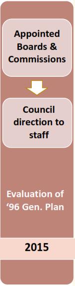
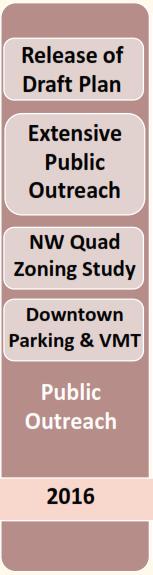
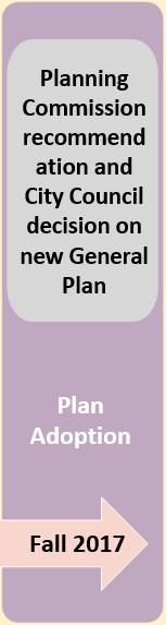
4 NEXT STEPS City Council review and feedback on Draft General Plan Publication of Draft EIR and Planning Commission hearing Planning Commission hearing and recommendations on Final EIR, Draft General Plan and implementing ordinances City Council hearing and decision on Final EIR, Draft General Plan and implementing ordinances April/May July September October


5 General Plan 2035: Public Participation 7 Open Houses & Farmers Markets 5 Neighborhood Forums 12 Appointed Commissions Input 4 Special District Boards City Council 341 Open Novato 16 Stakeholder Group Dialogues 4 Public Workshops Stakeholder Groups include: Community Groups Environmental Groups Business Groups
6 PUBLIC OUTREACH Presented the Draft General Plan to 630+ people in 48 meetings/venues Received 284 survey responses (45% response rate)
7 PUBLIC OUTREACH Organizations/Clubs: Novato Democratic Club Sunrise Rotary A.M Business Women North Marin Breakfast Club Novato Senior Citizen Club Soroptimist International Chamber of Commerce Marin Conservation League Sustainable Novato Novato Human Needs Center Historical Guild Rotary Club of Novato Sierra Club Marin Audubon Downtown Novato Business Association


8 PUBLIC OUTREACH Advertising: City webpage Novato Advance article Newspaper advertisements Next Door Facebook Hamilton Forum Farmers Market Booth Executive Summary and Displays
9 1. Senior living opportunities 2. Universal home design for elderly 3. Transportation supporting elderly/disabled 4. Increase Hispanic outreach/participation 5. Improve bike/pedestrian network 6. Maintain/expand parks & trails 7. Access to healthy foods/local food production 8. Active recreation in new developments 9. Retain small town character 10. New development sensitive to surroundings 11. Limit hillside/ridgeline development 12. Retain urban growth boundary 13. Northwest Quad neighborhood rezoning 14. Enforce property maintenance & traffic laws 15. Impact fees for new development 16. High level of police services 17. Maintain existing commercially zoned land 18. Recruit/retain businesses providing local 19. Recruit high-tech/life science firms 20. Assume limited new office/industrial 21. Redevelop N. Redwood for 22. Maintain/improve neighborhood retail 23. Local services & food near neighborhoods 24. Encourage hotels & auto dealerships 25. Downtown as center of the community 26. Pedestrian-oriented downtown development 27. Encourage downtown cafes/retail 28. Downtown public art & gathering places 29. Rezone N. Redwood (Vallejo to Olive) 30. Preserve historic buildings 31. New/widened streets include bike/ped 32. Encourage use of SMART 33. Create SMART bike/ped path 34. Transit improvements 35. Support shift to electric vehicles 36. Support new transportation technologies 37. Maintain traffic levels of service 38. Improve San Marin/Redwood/ Reduce greenhouse gasses 40. Reduce waste/increase recycling 41. Conserve energy and water 42. Expand recycled water system 43. Shift to renewable energy 44. Adopt green building standards 45. Plan for sea level rise, drought, wildfires 46. Focus new development near transit & 47. Encourage walking, biking & transit use 48. Protect open space & wildlife habitat 49. Maintain creek setbacks 50. Protect & restore wetlands 51. Maintain tidal areas in natural state 52. Minimize storm water runoff 53. Protect native trees & woodlands 54. Education & regulations for emergency 55. Emergency planning & training PUBLIC FEEDBACK Summary of General Plan Survey Feedback % Disagree % Agree
10 PUBLIC FEEDBACK Very High Level of Support for Plan Policies Average Agreement: 81% Average Disagreement: 5%
11 PUBLIC FEEDBACK Highest Rated Policies (90+% support): Recruit/retain businesses providing local services & high-paying jobs Conserve energy & water Expand recycled water system Encourage downtown cafes & retail Downtown as center of the community Pedestrian-oriented downtown development New development sensitive to its surroundings
12 PUBLIC FEEDBACK Highest Rated Policies (90+% support): Maintain/expand parks & trails Reduce waste/increase recycling Protect native trees & woodlands Maintain creek setbacks Minimize storm water runoff
13 PUBLIC FEEDBACK Other Policies Rated as Top Priorities: Improve bicycle & pedestrian infrastructure Provide a high level of police services Promote reinvestment in NW Quad with formbased zoning option Redevelop N. Redwood with vibrant retail/entertainment with public gathering places Encourage use of SMART
14 PUBLIC FEEDBACK Lowest Rated Policies: Encourage hotels & auto dealerships (23% disagreement, 47% agreement) Assume limited new office & industrial development (14% disagreement, 53% agreement)

15 COMMISSION & COMMUNITY ORGANIZATION FEEDBACK Feedback from Planning Commission, Design Review Commission, Bicycle & Pedestrian Advisory Commission, Economic Development Advisory Commission & Recreation, Cultural & Community Services Commission All Commissions commented the Draft Plan is attractive and well-written Feedback from Age-Friendly Novato, MCL, Marin Audubon, Marin Baylands Advocates and Sustainable Novato All suggestions/edits with staff responses in Attachment 8 & edits recommended by staff included in Attachments 9-11
16 COUNCIL FIRST-PASS EDITS Review monthly in 3-Chapter segments Substantive changes may affect EIR project description and scope Attachments 9-11 include edits recommended by staff from input by Commissions, community organizations & City Councilmembers
17 COUNCIL FIRST-PASS EDITS First 3 Segments: Introduction Great Places (land use & community design) Draft Downtown Design Guidelines
18 COUNCIL FIRST-PASS EDITS Suggested Order: Staff Presentation Public Comment Council Questions, Comments and Feedback on selected text, policies and programs: UGB Extension FAR Computation for Structured Parking Great Places Programs LU13a & 19a and Policy CC 3 Selected portions of Introduction, Great Places and Downtown Design Guidelines
19 COUNCIL FIRST-PASS EDITS Council Objectives: Gain incremental input from public, Commissions and Council prior to drafting Plan Concise, readable, attractive document Utilize much of 1996 General Plan Reflect need for fiscal sustainability in programs
20 UGB EXTENSION 2014 Council direction: extend UGB in place for another 20 years by Council action UGB Ordinance will be updated by City Attorney for either Council adoption or public ballot with involvement of environmental groups, LAFCO and utility districts Council could place on public ballot in early August. Election cost of ~$50,000-94,000 + CEQA analysis $20,000-40,000 Council will need to adopt a bridge ordinance for November period between expiration of existing UGB and election date
21 UGB EXTENSION LU 5a: UGB Extension. On or before the expiration of the voter approved Urban Growth boundary, the City Council will consider place on the public ballot extending an extension of the term of the Urban Growth Boundary to improve the City s ability to provide municipal services and discourage urban sprawl and the provision of urban services to property outside the City limits.
22 FAR CALCULATION Allowable Floor Area Ratio (FAR) downtown is 2.0 (max. building area twice the lot size) Definition of FAR specifically excludes covered parking or garages Councilmember Eklund suggests that a program be included in the Land Use Chapter for staff to disclose total floor area ratio (FAR) for mixed use projects that have structured parking
23 PUBLIC COMMENT
24 LU 13a LU 13a: Zoning Regulations. Consider an update to ground floor use regulations to include a provision for uses or buildings that warrant an exception establish limits to avoid overconcentration of certain personal service uses and eliminate tobacco product shops as an allowed use.

25 LU 19a LU 19a: Rezoning. Rezone and change the General Plan Land Use Map for properties along Redwood Boulevard between Vallejo Avenue and Pinheiro Circle, as identified as Site 1 in Figure GP-7, from General Commercial to Downtown Core.
26 CC 3 CC 3: Hillsides. Protect Novato s hillsides and ridgelines from erosion, slope failure and visual impacts by limiting the extent and location or new development and ensuring that new development complies with the requirements of the Hillside and Ridgeline Protection ordinance in the Zoning Code.
27 COUNCIL FIRST-PASS EDITS Selective discussion of text, policies or programs: Introduction Great Places Downtown Design Guidelines
Remi Mendoza City Planning Academy March 13, 2017
 Remi Mendoza City Planning Academy March 13, 2017 1 What is the General Plan? The 2030 General Plan 5-Year Update (2035 General Plan) Questions and Answers 2 Guidebook for development and growth Required
SAN RAFAEL GENERAL PLAN 2040 INTRODUCTION AND OVERVIEW
 SAN RAFAEL GENERAL PLAN 2040 INTRODUCTION AND OVERVIEW Steering Committee Presentation February 14, 2018 Purpose of General Plan Guide land use and development decisions Coordinate transportation, infrastructure,
EXISTING COMPREHENSIVE PLAN
 EXISTING COMPREHENSIVE PLAN Town Center Land Use Element: V. LAND USE POLICIES Town Center Mercer Island's business district vision as described in "Your Mercer Island Citizen-Designed Downtown" was an
SONOMA LOCAL AGENCY FORMATION COMMISSION
 For accessibility assistance with any of the following documents, please contact Sonoma LAFCO at (707) 565-2577 or email us at cynthia.olson@sonoma-county.org. SONOMA LOCAL AGENCY FORMATION COMMISSION
2035 General Plan Update and Belmont Village Specific Plan. Joint Study Session with the City Council and Planning Commission April 12, 2016
 2035 General Plan Update and Belmont Village Specific Plan Joint Study with the City Council and Planning Commission April 12, 2016 Agenda 1. Welcome and Introductions 2. General Plan Update Status of
PINE CURVE REZONING. BACKGROUND Purchased as two parcels in 2001 and 2002
 BACKGROUND Purchased as two parcels in 2001 and 2002 WHAT THE PROJECT IS AND IS NOT A Rezoning establishes the land use standards for Annexed and Zoned Greater Downtown District Historic Center September
Endorse the Alameda Point Conceptual Planning Guide
 CITY OF ALAMEDA Memorandum To: From: Honorable Mayor and Members of the City Council John A. Russo City Manager Date: July 23,2013 Re: Endorse the Alameda Point Conceptual Planning Guide BACKGROUND The
CENTRAL ESTUARY PLAN AVISION FOR OAKLAND S WATERFRONT
 Central Estuary Plan A VISION FOR OAKLAND S WATERFRONT Specific Plan and Environmental Assessment Presentation to the Parks and Recreation Advisory Commission December 9, 2009 This Afternoon s Presentation
Introduction and Overview
 Introduction and Overview Articulate local values and priorities Guide land use and development decisions Coordinate transportation, infrastructure, and City services with expected growth and available
ADOPTION OF THE REVISED OPEN SPACE AND CONSERVATION ELEMENT OF THE GENERAL PLAN
 TO: FROM: SUBJECT: Honorable Mayor and City Council Planning Department ADOPTION OF THE REVISED OPEN SPACE AND CONSERVATION ELEMENT OF THE GENERAL PLAN RECOMMENDATION: It is recommended that the City Council:
Urban Planning and Land Use
 Urban Planning and Land Use 701 North 7 th Street, Room 423 Phone: (913) 573-5750 Kansas City, Kansas 66101 Fax: (913) 573-5796 Email: planninginfo@wycokck.org www.wycokck.org/planning To: From: City Planning
PINE CURVE REZONING. Property does not meet criteria for open space preservation and is not a candidate for a park
 PINE CURVE REZONING BACKGROUND Purchased as two parcels in 2001 and 2002 Annexed and Zoned Greater Downtown District Historic Center September 25, 2002 and October 7, 2002 WHAT THE PROJECT IS AND IS NOT
Municipal Plan*Assessment
 Municipal Plan*Assessment This tool was developed to assist in reviewing municipal master plans and in determining if these plans are consistent with smart growth principles, neighboring municipal plans,
Introduction. Chapter 1. Purpose of the Comprehensive Plan Plan Organization Planning Process & Community Input 1-1
 Chapter 1 Introduction Lakewood 2025: Moving Forward Together Purpose of the Comprehensive Plan Plan Organization Planning Process & Community Input 1-1 Purpose of the Comprehensive Plan The Comprehensive
NORTH, NORTH REDWOOD BOULEVARD CORRIDOR STUDY
 BOULEVARD CORRIDOR STUDY Southern Central Northern STUDY AREA OPPORTUNITIES AND CONSTRAINTS BOULEVARD CORRIDOR WORKSHOP Constraints Wetlands For illustrative purposes only BINFORD RD RUSH LANDING RD BOULEVARD
Isabel Neighborhood Plan: Alternatives
 Isabel Neighborhood Plan: Alternatives Presented by: Lori Parks, Associate Planner February 2, 2015 Agenda 1. Background on BART to Livermore 2. Isabel Neighborhood Plan 3. Alternative Scenarios 4. General
A. WHAT IS A GENERAL PLAN?
 I. Introduction A. WHAT IS A GENERAL PLAN? A general plan is the planning guideline for the future of a city. It contains goals and policies which regulate urban development, the protection of the natural
PLAN ELEMENTS WORKSHOP. April 5, 2016
 PLAN ELEMENTS WORKSHOP April 5, 2016 needs more housing. But there is no one-size fits-all solution. Every neighborhood has its own character. In some places, density is not only appropriate it is badly
S A C R A M E N T O C O U N T Y JACKSON HIGHWAY & GRANT LINE EAST VISIONING STUDY
 JACKSON HIGHWAY & GRANT LINE EAST S A C R A M E N T O C O U N T Y P L A N N I N G D E P A R T M E N T SUMMARY AND WORKBOOK November 19, 2008 History of the Visioning Study Sacramento County has two growth
CITY OF CHARLOTTESVILLE, VIRGINIA CITY COUNCIL AGENDA
 CITY OF CHARLOTTESVILLE, VIRGINIA CITY COUNCIL AGENDA Agenda Date: December 16, 2013 Action Required: Adoption of Resolution Presenter: Staff Contacts: Title: James E. Tolbert, AICP, Director of NDS James
DRAFT PLAN PRESENTATION
 DRAFT PLAN PRESENTATION 1.23.2018 AGENDA Process Project Schedule Results from Visioning Workshop Draft Plan Highlights Concept Plans Feedback Next Steps PROJECT SCHEDULE KICK-OFF WORKSHOP August 29 th
CHAPTER 7: Transportation, Mobility and Circulation
 AGLE AREA COMMUNITY Plan CHAPTER 7 CHAPTER 7: Transportation, Mobility and Circulation Transportation, Mobility and Circulation The purpose of the Transportation, Mobility and Circulation Chapter is to
City Council Special Meeting AGENDA ITEM NO. C.
 City Council Special Meeting AGENDA ITEM NO. C. DATE: 01/04/2019 TO: Honorable Mayor and City Council Members SUBJECT: Transit Villages Specific Plan project Study Session (Development Services Director
CPD Rules and Regulations. Arapahoe Square Zoning and Design Standards/Guidelines
 CPD Rules and Regulations Arapahoe Square Zoning and Design Standards/Guidelines Denver Planning Board May 4 th, 2016 Sponsor & Community Partners Sponsored by Albus Brooks, Council District 9 Developed
Future Land Use SAMPLE RECOMMENDATIONS
 SAMPLE RECOMMENDATIONS Future Land Use The Future Land Use Chapter of the Master Plan builds upon prior chapters examining the existing conditions in their respective topic areas to present a comprehensive
Presentation to Town Council in association with Kubilins Transportation Group Rose & Associates Equinox Environmental
 Presentation to Town Council 03.03.09 in association with Kubilins Transportation Group Rose & Associates Equinox Environmental Vision Statement: Boone 2030 is...a friendly, vibrant, attractive community...financially,
Staff Report to the North Ogden City Planning Commission
 Staff Report to the North Ogden City Planning Commission SYNOPSIS / APPLICATION INFORMATION Application Request: Concept review on a legislative application to rezone land located at approximately 1750
CITY OF ANN ARBOR MASTER PLAN. Land Use Element
 CTY OF ANN ARBOR MASTER PLAN Land Use Element June 15, 2009 Prepared by the Ann Arbor City Planning and Development Services Unit and the City of Ann Arbor Planning Commission City Master Plan: Land Use
Date: April 10, 2017 City Council Work Session April 24, 2017: Status Report on the Comprehensive Plan Update and Transportation Master Plan
 AGENDA REPORT To: From: By: Honorable Mayor and City Council Members Warren Hutmacher, City Manager Sharon Ebert, Director Community Development Date: April 10, 2017 Agenda: City Council Work Session April
Tyvola & Archdale Transit Station Area Plan. June 5, 2008
 Tyvola & Archdale Transit Station Area Plan Second Public Meeting June 5, 2008 Presentation Outline 1. Purpose and Process 2. Station Area Overview 3. Plan Recommendations 4. Comments Received and Proposed
4. ENVIRONMENTAL IMPACT ANALYSIS 7. LAND USE AND PLANNING
 4. ENVIRONMENTAL IMPACT ANALYSIS 7. LAND USE AND PLANNING 4.7.1 INTRODUCTION The following analysis discusses the consistency of the Proposed Project with the corresponding land use and zoning designations
Chapter 2: Vision, Goals and Strategies
 Chapter 2: Vision, Goals and Lake Elmo Today & Tomorrow Comprehensive Plan 2040 2 VISION, GOALS & STRATEGIES - DRAFT 4-6-2018 INTRODUCTION Comprehensive Plan Purpose Perhapse the most important objective
Communities Plan. Parkland-Spanaway-Midland. LUAC Review of Draft Policies
 Parkland-Spanaway-Midland Communities Plan LUAC Review of Draft Policies Presented by: Tiffany O Dell, Senior Planner Planning & Public Works Tiffany.Odell@co.pierce.wa.us 253-798-6859 November 1, 2017
Public input has been an important part of the plan development process.
 Lakewood s Comprehensive Plan recognizes that transportation helps shape the community, and that the way the community provides for the safe and efficient movement of people affects the character of the
Unified Development Code (UDC) Revision
 Revision") Unified Development Code (UDC) Revision Update Brief George Haggerty Acting Land Use General Manager Department of Land Use NCC Council Land Use Workshop Briefing January 5, 2016 Summary Background (Outreach
Unified Development Code (UDC) Revision Update Brief George Haggerty Acting Land Use General Manager Department of Land Use NCC Council Land Use Workshop Briefing January 5, 2016 Summary Background (Outreach
CHARLES PUTMAN CHARLES PUTMAN AND ASSOCIATES, INC
 MEMORANDUM CHARLES PUTMAN & ASSOCIATES, INC. LAND DEVELOPMENT CONSULTANTS PLANNING ZONING PERMITTING 4722 NW Boca Raton Boulevard, Suite C-106 Boca Raton, Florida 33431 Phone: 561/994-6411 FAX: 561/994-0447
Clovis Urban Greening Plan. Community Workshop #2 Northwest
 Clovis Urban Greening Plan Community Workshop #2 Northwest Thursday, October 9, 2014 WHAT IS AN URBAN GREENING PLAN? A guide to help the City to improve quality of life for residents Identification of
7Page 1 CLEMMONS COMMUNITY COMPASS 1 PLAN OVERVIEW
 1 Plan Overview WHAT IS I THE CLEMMONS COMMUNITY COMPASS? The Clemmons Community Compass is our community s comprehensive plan. It serves as our blueprint and provides direction for the future of the Village
WAC #7 3/14/14. Coachella General Plan Update
 WAC #7 3/14/14 Coachella General Plan Update Agenda 2 Introductions Public Draft General Plan Overview and Discussion of Next Steps Implementation and Evaluation Health Element Process Evaluation (discussion)
General Plans. Tom Dansie, AICP Steve Pastorik, AICP
 General Plans Tom Dansie, AICP Steve Pastorik, AICP General Plans What is a General Plan? What does State code say? How is a General Plan used? How is a General Plan developed? Suggested considerations
Town Center (part of the Comprehensive Plan)
") Town Center (part of the Comprehensive Plan) Mercer Island Town Center Looking North (2014) In 1994, a year-long process culminated in a set of design guidelines and code requirements for the Town Center
Town Center (part of the Comprehensive Plan) Mercer Island Town Center Looking North (2014) In 1994, a year-long process culminated in a set of design guidelines and code requirements for the Town Center
Department of Community Development. Planning and Environmental Review Division Revised Notice of Preparation
 Department of Community Development Michael J. Penrose, Acting Director Divisions Building Permits & Inspection Code Enforcement County Engineering Economic Development & Marketing Planning & Environmental
10 Implementation. Implementation. Responsibility for Implementation. Blueprint for Bloomsburg. Town of Bloomsburg Comprehensive Plan 10-1
 Implementation 10 Implementation This chapter overviews how to use the comprehensive plan as a land use and programming tool for the Town of Bloomsburg and recommends annual review of the plan by the Town
A larger version of this map is located on the last page of this PDF.
 MAP Committee Input McLoughlin Area Draft Vision Map A larger version of this map is located on the last page of this PDF. 1. The map above is intended to portray a vision for the McLoughlin area. It highlights
Tyvola & Archdale Transit Station Area Plan. May 15, 2008
 Tyvola & Archdale Transit Station Area Plan First Public Meeting May 15, 2008 Presentation Outline 1. Purpose and Process 2. Station Area Overview 3. Plan Recommendations Vision Land Use Transportation
Table L-1 Summary Action Strategy. Action Item Timing Status Responsible Agency
 CHAPTER 4: CIRCULATION ELEMENT ISSUE #1: MAJOR THOROUFARES AND TRANSPORTATION ROUTES A balanced transportation system for Fontana is provided that meets the mobility needs of current and future residents
University of the District of Columbia Van Ness Campus Master Plan Community Open House 3. December 8, 2010
 University of the District of Columbia Van Ness Campus Master Plan Open House 3 December 8, 2010 Introductions Sequence of Work: Campus Master Plan BEGIN: INTRODUCE AND START WORK Project Initiation Team
CHAPTER 1. Ms. Guajardo s Class - Central Elementary CH 1 1
 INTRODUCTION CHAPTER 1 Ms. Guajardo s Class - Central Elementary CH 1 1 1.1 SETTING South Centre City is a linear corridor south of Downtown Escondido paralleling Centre City Parkway and South Escondido
Status Report: MD 355 Project
 Status Report: MD 355 Project OCTOBER 2006 M-NCPPC MONTGOMERY COUNTY PLANNING DEPARTMENT Summary of Community Comments, and break to the Results of the MD 355 Participation Session Brookside Gardens -
Independence Boulevard Area Plan Planning Committee Public Comment May 18, 2010
 Independence Boulevard Area Plan Planning Committee Public Comment May 18, 2010 Presentation Outline Focus on Key Recommendations within Draft Plan Plan Purpose and Development Process Draft Plan Policies
One said, without a clear understanding of what will be annexed, this is an exercise in futility.
 Stakeholder Focus Groups: Summary of Meetings Stakeholder Focus Group meetings were held on at the Pinellas County Planning Department conference room. Focus Group meetings will be held during each of
A BLUEPRINT FOR BROCKTON A CITY-WIDE COMPREHENSIVE PLAN
 A BLUEPRINT FOR BROCKTON A CITY-WIDE COMPREHENSIVE PLAN Public Meeting October 2016 1 Plan Summary and Discussion Public Meeting May 4 2017 City of Brockton Bill Carpenter, Mayor Department of Planning
TRANSFORM BALTIMORE NEW ZONING CODE
 Laurie Feinberg, Asst. Director 4/26/2017 1 History and Summary of Process Principles of the code New Designations Use Tables Bulk Regulations Design and Landscape Guidelines Liquor Outlet Reduction Urban
Staff Report and Recommendation
 Community Planning and Development Planning Services 201 W. Colfax Ave., Dept. 205 Denver, CO 80202 p: 720.865.2915 f: 720.865.3052 www.denvergov.org/cpd TO: City Council Neighborhoods and Planning Committee
Dignowity Hill Neighborhood Plan & Eastside Reinvestment Plan
 Dignowity Hill Neighborhood Plan & Eastside Reinvestment Plan Rebecca Paskos, Senior Planner Neighborhood & Urban Design Division Planning & Community Development Department City of San Antonio (210) 207-7816
JANUARY 19, 2011 CENTRAL AVENUE-METRO BLUE LINE TRANSIT-ORIENTED DEVELOPMENT IMPLEMENTATION PROJECT COMMUNITY FORUM
 CENTRAL AVENUE-METRO BLUE LINE TRANSIT-ORIENTED DEVELOPMENT IMPLEMENTATION PROJECT COMMUNITY FORUM JANUARY 19, 2011 THE MARYLAND-NATIONAL CAPITAL PARK AND PLANNING COMMISSION PRINCE GEORGE S COUNTY PLANNING
NOTICE OF PREPARATION
 NOTICE OF PREPARATION DATE: April 6, 2017 TO: FROM: Responsible Agencies Trustee Agencies Local and Public Agencies Interested Parties Contact: Brent Cooper, AICP, Community Development Director 4381 Broadway
Future Proposed Development
 Future Proposed Development on and around Link light rail s Capitol Hill Station Meeting September 24, 2012 Tonight s Agenda 6:00 pm Open House 6:30 pm Introductions Richard Conlin, City of Seattle Councilmember/Sound
Union City General Plan Update. City Council Meeting Item VII.a July 28, 2015 Land Use Concepts and Evaluation Criteria
 Union City General Plan Update City Council Meeting Item VII.a July 28, 2015 Land Use Concepts and Evaluation Criteria Meeting Outline The Update Process Overview and Purpose Draft Focus Area Concepts
Town of Peru Comprehensive Plan Executive Summary
 Town of Peru Comprehensive Plan Executive Communities that plan grow by choice, not by chance. A plan makes growth thoughtful, understandable, and predictable. A plan shows that a community is managing
Memorandum Planning. Thursday, January 8, 2015
 Memorandum Planning Thursday, January 8, 2015 7.A. To: Coastal Advisory Committee From John Ciampa, Associate Planner Subject: Review Draft Local Coastal Program Copies: James Pechous, City Planner Purpose
City of Richland Comprehensive Plan: Integrated Non-project Final Environmental Impact Statement
 City of Richland Comprehensive Plan: Integrated Non-project Final Environmental Impact Statement September 12, 2017 Prepared for: City of Richland Prepared by: Oneza & Associates With assistance from:
CITY OF PUYALLUP. Background. Development Services
 CITY OF PUYALLUP Development Services 333 South Meridian Puyallup WA 98371 To: City Council From: Katie Baker, AICP, Planning Division Re: South Hill Neighborhood Plan Adoption Date: (Meeting date: February
It Takes A Village.. Preserving Rural Character In Standish
 It Takes A Village.. Preserving Rural Character In Standish A Public Workshop Hosted by Conservation and Open Space Plan Committee & Standish Corner Village Implementation Committee June 12, 2008 Desired
AvalonBay Communities + BRIDGE Housing. Mission Housing Habitat for Humanity Pacific Union Development Corporation
 AvalonBay Communities + BRIDGE Housing Mission Housing Habitat for Humanity Pacific Union Development Corporation Tonight s Agenda Recap of discussion from last CAC meeting Updates on meetings with Stakeholders
CITY OF SACRAMENTO GENERAL PLAN. UC Davis ESP 171 Urban and Regional Planning April 21, 2011
 CITY OF SACRAMENTO GENERAL PLAN UC Davis ESP 171 Urban and Regional Planning April 21, 2011 1 OUTLINE Background Growth and Change Placemaking Sustainability and Climate Change Economic Development 2 City
Executive Summary. The Mebane CLP is not a regulatory document, but is intended to guide land development decisions. The plan includes:
 Executive Summary P URPOSE AND O RGANIZATION OF THE P LAN The City of Mebane, with input from citizens and an appointed CLP Advisory Committee, adopted Mebane by Design, a Comprehensive Land Development
Aloha Tomorrow Study (2017)
") Study (2017) One step toward implementing the community vision from the Aloha-Reedville Study and Livable Community Plan (2014): A walkable, vibrant, livable town center with a mix of commercial and residential
Study (2017) One step toward implementing the community vision from the Aloha-Reedville Study and Livable Community Plan (2014): A walkable, vibrant, livable town center with a mix of commercial and residential
City Plan Commission Briefing #2
 City Plan Commission Briefing #2 August 2, 2016 Image Source City of Richardson Agenda Project Overview / Progress to Date Property and Business Owner Meeting Series 2 Community Workshop 2 Belt Line Road
MEMO 1. INTRODUCTION PURPOSE & PROCESS REQUEST
 MEMO Date: August 22, 2017 To: Board of Commissioners From: Jason Burdette, Planning Director Re: Davidson Commons East Hotel Stakeholder Feedback 1. INTRODUCTION PURPOSE & PROCESS This memorandum summarizes
Leonard s Beach Secondary Plan (Alcona North) Official Plan Amendment
 Official Plan Amendment") Leonard s Beach Secondary Plan (Alcona North) Official Plan Amendment Public Meeting Presentation August 14, 2013 Note: This document is for presentation purposes only. Please see Staff Report DSR-135-13
Leonard s Beach Secondary Plan (Alcona North) Official Plan Amendment Public Meeting Presentation August 14, 2013 Note: This document is for presentation purposes only. Please see Staff Report DSR-135-13
Community Workshop November 19, 2014
 Community Workshop November 19, 2014 Agenda Welcome and Introduction What is a General Plan? About the General Plan Update Our General Plan Topics to be included in the Update Update process Opportunities
South Central Connecticut Region Plan of Conservation & Development 2018 Update. Municipal Planners
 South Central Connecticut Region Plan of Conservation & Development 2018 Update Municipal Planners July 28th, 2017 1 Introductions 2 Purpose of Today s Meeting Supplement data analysis with qualitative
PLANNED UNIT DEVELOPMENT STAFF REPORT Date: June 2, 2016
 # 9 ZON2016-01032 PLANNED UNIT DEVELOPMENT STAFF REPORT Date: June 2, 2016 DEVELOPMENT NAME JJT Properties LLC LOCATION 1147 & 1151 East I-65 Service Road South and 1180 Sledge Drive (Southeast corner
TABLE OF CONTENTS. Tables Table UC Davis Park and Open Space Resources
 TABLE OF CONTENTS 4.13 Recreation... 4.13-1 4.13.1 Environmental Setting... 4.13-1 4.13.2 Impacts and Mitigation Measures... 4.13-4 4.13.3 References... 4.13-8 Tables Table 4.13-1 UC Davis Park and Open
1.0 Purpose of a Secondary Plan for the Masonville Transit Village
 Report to Planning and Environment Committee To: Chair and Members Planning & Environment Committee From: John M. Fleming Managing Director, Planning and City Planner Subject: Masonville Transit Village
RESOLUTION NO. R Refining the route, profile and stations for the Downtown Redmond Link Extension
 RESOLUTION NO. R2018-32 Refining the route, profile and stations for the Downtown Redmond Link Extension MEETING: DATE: TYPE OF ACTION: STAFF CONTACT: Capital Committee Board PROPOSED ACTION 09/13/2018
GENERAL PLAN AND ENVIRONMENTAL IMPACT REPORT
 City of Menifee HEARING DRAFT GENERAL PLAN AND ENVIRONMENTAL IMPACT REPORT City Council November 2013 PURPOSE OF MEETING Overview of GP Process Overview of required and optional GP elements Receive direction
2016 Sustainable Comprehensive Plan Public Hearing
 2016 Sustainable Comprehensive Plan Public Hearing March 15, 2016 Draft Vision Statement The Town of Cortlandt s identity is strongly linked to its historical roots and the Hudson River. The Town wishes
TRANSFORM BALTIMORE NEW ZONING CODE. Laurie Feinberg, Asst. Director
 Laurie Feinberg, Asst. Director 4/5/2017 1 History and Summary of Process Principles of the code New Designations Use Tables Bulk Regulations Design and Landscape Guidelines Liquor Outlet Reduction Urban
MONTCO 2040: A SHARED VISION The New Comprehensive Plan for Montgomery County. Dra Themes and Goals March, 2014
 MONTCO 2040: A SHARED VISION The New Comprehensive Plan for Montgomery County Dra Themes and Goals March, 2014 INTRODUCTION 2 WHAT IS A COMPREHENSIVE PLAN? A comprehensive plan is a long-range plan required
From: Mayor Sam Liccardo Councilmember Chappie Jones Councilmember Dev Davis Subject: SEE BELOW Date: June 23, 2017
 CITY OF fit SAN JOSE CAPITAL OF SILICON VALLEY Memorandum, To: HONORABLE MAYOR AND CITY COUNCIL From: Mayor Sam Liccardo Councilmember Chappie Jones Councilmember Dev Davis Subject: SEE BELOW Date: June
Keyport. Vision for Keyport
 Keyport Vision for Keyport Keyport is a rural, historic waterfront village bounded and limited in size by its natural borders of water and the Naval Undersea Warfare Center. The community consists primarily
Por favor, levanten la mano si necesita traduccion en espanol Please raise your hand if you need Spanish translation
 FEDERAL BOULEVARD CORRIDOR WIDE STUDY PUBLIC MEETING #1 APRIL 27, 2016 Por favor, levanten la mano si necesita traduccion en espanol Please raise your hand if you need Spanish translation HDR DESIGN WORKSHOP
TO: Denver Planning Board FROM: Analiese Hock, Senior City Planner DATE: March 13, 2018 RE:
 Community Planning and Development Planning Services 201 W. Colfax Ave., Dept. 205 Denver, CO 80202 p: 720.865.2915 f: 720.865.3052 www.denvergov.org/cpd TO: Denver Planning Board FROM: Analiese Hock,
India Basin/Hunters Point Shoreline Community Workshop May 21, 2008
 India Basin/Hunters Point Shoreline Community Workshop May 21, 2008 Workshop Agenda Welcome Process Overview Context & Existing Conditions Presentation of Draft Concepts Land Use and Open Space Priorities
Kelowna Sustainability Checklist
 Kelowna Sustainability Checklist The City of Kelowna endeavours to Sustain the Environment. Encourage development and land use changes that will not compromise the ability of future generations to meet
Key Concepts of the General Plan
 Key Concepts of the General Plan General Plan Purpose Vision for City s future Standards for City Services Land Use Plan General Plan Purpose San Jose is creating its Blueprint for the Future to become
South of Eastern Strategic Direction Status Update
 STAFF REPORT ACTION REQUIRED South of Eastern Strategic Direction Status Update Date: July 10, 2014 To: From: Planning and Growth Management Committee Chief Planner and Executive Director, City Planning
City of San Ramon. Zoning Ordinance. Adopted: October 27, Latest Revisions Effective: March 28, 2018
 City of San Ramon Zoning Ordinance Adopted: October 27, 2015 Latest Revisions Effective: March 28, 2018 City of San Ramon 7000 Bollinger Canyon Road San Ramon, California 94583 [Page intentionally left
1INTRODUCTION. Purpose of the Truckee Railyard Master Plan
 1INTRODUCTION Purpose of the Truckee Railyard Master Plan The purpose of the Truckee Railyard Master Plan is to capture and describe the Town s vision for the Railyard Area and to guide its future redevelopment.
2040 LUP is a part of the Comprehensive Plan and carries the same legal authority. Economic Challenges
 1.1. Guiding Anchorage s Growth Where will new residents settle over the next two decades? Where will people work, shop, and play? Will there be enough room to grow? How will Anchorage look? Will growth
Rezoning Petition Pre-Hearing Staff Analysis May 21, 2018
 Rezoning Petition 2018-018 Pre-Hearing Staff Analysis May 21, 2018 REQUEST Current Zoning: R-5 (single family residential), R-5 HD-O (single family residential, historic district overlay) and B-2(CD) HD-O
City Center Specific Plan Amendments And Background Report City of Richmond. PLANNING COMMISION FINAL DRAFT January, 2001
 City Center Specific Plan Amendments And Background Report City of Richmond PLANNING COMMISION FINAL DRAFT January, 2001 TABLE OF CONTENTS Page LIST OF TABLES... LIST OF FIGURES... INDEX... OVERVIEW...
Secrest Short Cut and Monroe Expressway Small Area Plan AUGUST 29, 2018
 Secrest Short Cut and Monroe Expressway Small Area Plan AUGUST 29, 2018 Background and Process Monroe Expressway will be open by the end of 2018 Union County and Indian Trail identified a need to revisit
CITY OF UNION CITY MINUTES GENERAL PLAN ADVISORY COMMITTEE
 CITY OF UNION CITY MINUTES GENERAL PLAN ADVISORY COMMITTEE WEDNESDAY, MARCH 4, 2015, 6:30 P.M. IN THE CITY COUNCIL CONFERENCE ROOM OF CITY HALL 34009 ALVARADO-NILES BLVD., UNION CITY, CALIFORNIA Attachment
3.1 community vision. 3.3 required plan elements
 Chapter 3 Community Form 3.1 community vision 3.2 Parks & landscaping concepts 3.3 required plan elements D R A F T 20 Community Form Chapter 3 3.0 Community form 3.1 community vision The Specific Plan
Living in Albemarle County s Urban Places
 Living in Albemarle County s Urban Places ALBEMARLE COUNTY, VIRGINIA A Closer Look at Albemarle s Approach to Managing Growth and Creating Quality Urban Environments www.albemarle.org Page 2 Living in
Plan-It Greenville (2009) Comprehensive Plan 5-Year Update
 Comprehensive Plan 5-Year Update") Plan-It Greenville (2009) Comprehensive Plan 5-Year Update What is the comprehensive plan: Collecting communitywide data Projecting future population growth Setting communitywide goals Framing policies
Plan-It Greenville (2009) Comprehensive Plan 5-Year Update What is the comprehensive plan: Collecting communitywide data Projecting future population growth Setting communitywide goals Framing policies
LAND USE AMENDMENT DOWNTOWN COMMERCIAL CORE (WARD 7) MACLEOD TRAIL SE AND 5 AVENUE SE BYLAW 254D2017
 MACLEOD TRAIL SE AND 5 AVENUE SE BYLAW 254D2017") Page 1 of 10 EXECUTIVE SUMMARY This Land Use Amendment application seeks to redesignate a full downtown block (currently the YWCA site) from a Direct Control based on the CM-2 District (Land Use Bylaw
Page 1 of 10 EXECUTIVE SUMMARY This Land Use Amendment application seeks to redesignate a full downtown block (currently the YWCA site) from a Direct Control based on the CM-2 District (Land Use Bylaw