Planning Rationale Zoning By-law Amendment Application October Centrepointe Drive - Ottawa, Ontario
|
|
|
- Allen Dalton
- 5 years ago
- Views:
Transcription


1 ZONING BYLAW AMENDMENT OCTOBER 2011
2 Table of Contents Table of Contents... i 1 Introduction Site Location Overview of Proposed Development Context Community Character Immediate Site Context Transportation Context (Road & Transportation Network) Policy and Regulatory Framework Provincial Policy Statement City of Ottawa Official Plan (2003) Baseline and Woodroffe Secondary Plan City of Ottawa Zoning By-law Centrepointe Town Centre Workshop Summary Report Summary of Technical Studies Transportation Brief Servicing Brief Conclusions i P a g e
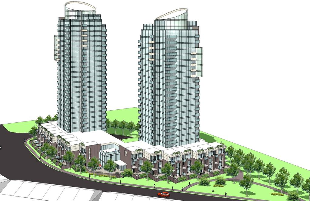
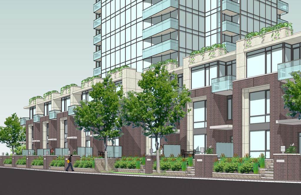
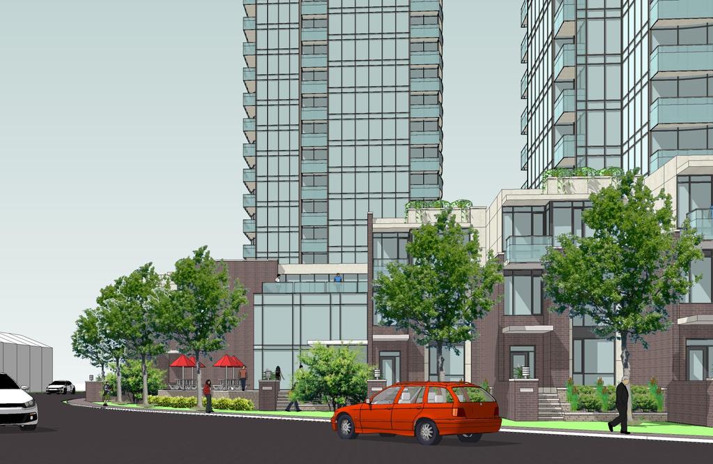
3 1 INTRODUCTION The purpose of this report is to review and assess the appropriateness of a Zoning By-law Amendment proposed by Richcraft Group of Companies in the context of the surrounding community and the City s direction and strategies for growth and development. The proposed amendment would involve an increase of the permitted height to 74 m and the permitted Floor Space Index (FSI) to SITE LOCATION The 0.76 ha (1.88 acre) site known municipally as 19 Centrepointe Drive is located in the Centrepointe area of the City of Ottawa. The site is a vacant, irregularly shaped corner lot southeast of the intersection of Centrepointe Drive and Constellation Crescent. 1.2 OVERVIEW OF PROPOSED DEVELOPMENT The proposed development would consist of two (2) highrise residential buildings that are wrapped by a threestorey podium that will consist primarily of street level townhouses and a coffee shop with a patio located along Centrepointe Drive. One (1) of the towers would be twenty-four (24) storeys in height including the podium; the other would be twenty-two (22) storeys in height including the podium. Both towers have been designed with a slender footprint in order to maximize sunlight and a feeling of openness within the surrounding development context. The podium townhouses will front onto and have direct pedestrian access to the east side of Centrepointe Drive. All vehicular access to the proposed development will be accommodated off Constellation Crescent to the north leading to a drop-off area and underground parking entrance on the east side of the building. The proposed development can be better understood by referring to the Site Plan and development perspectives on the following pages. 1 P a g e
4 2 P a g e
5 3 P a g e
6 4 P a g e
7 5 P a g e
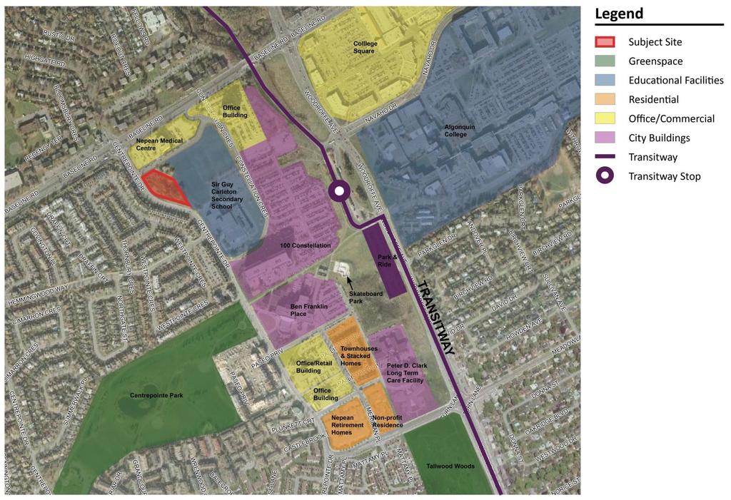
8 2 CONTEXT 2.1 IMMEDIATE SITE CONTEXT The Centrepointe community is a residential neighbourhood consisting predominantly of townhouses and single-detached homes with a range of additional community facilities and amenities. The adjacent land uses to the site are as follows: North: The Nepean Medical Centre - a four (4) storey medical office building with a large surface parking area. East: Sir Guy Carleton Secondary School is adjacent to the site. North of the two (2) storey school building are two (2) soccer fields that are immediately adjacent to the eastern edge of the subject site. South and West: Given the fact that Centrepointe Drive bends east as it extends south along the western edge of the subject site, rows of two (2) to three (3) storey townhouses that align most of the opposite side of Centrepointe Drive are effectively located west and south of the proposed development. 2.2 COMMUNITY CONTEXT AND AMENITIES In addition to the land uses adjacent to the site, there are a variety of community amenities, facilities, and municipal buildings that compliment the predominantly residential character of the Centrepointe community. Southeast of the site just past the Secondary School is a nine (9) storey municipal office building at 100 Constellation Crescent. Further southeast, approximately 500 metres away, is Ben Franklin Place which houses a theatre and a library in addition to various municipal offices. Within 500 metres east of the site, on either side of Woodroffe Avenue, lies Algonquin College. Immediately north of Algonquin at the southeast corner of Baseline Road and Woodroffe Avenue is a large shopping plaza (College Square) with a selection of retail stores and a grocery store. Centrepointe Park is located within 500 metres southwest of the site providing soccer fields, baseball diamonds, and a children s playground. This park is approximately 35 acres in area and has a large passive greenspace and pathways surrounding a central pond feature. Pinecrest Recreation Complex is located approximately 400 metres northwest of the site. This facility includes an indoor pool, hockey arena, exercise facilities, baseball diamonds, a football field and tennis courts. The Pinecrest complex is flanked to the east by Bishop Hamilton Christian School. Finally, further east within 400 and 700 metres of the site respectively are Deslauriers Public Elementary School and St. Daniel Secondary Elementary School. The figure on the following page illustrates a number of these amenities however, the underlying aerial photo and the corresponding transit station label do not reflect the current station location that has been shifted west within 400 metre of the subject site. 6 P a g e
9 7 P a g e
10 2.3 TRANSPORTATION CONTEXT (ROAD & TRANSPORTATION NETWORK) The proposed development is accessible and well served by Transit. At the intersection of Baseline Road and Centrepointe Drive, there is a Transit stop which services Regular Bus Route 118 and Express Route 179. South of the subject site; at the intersection of Hemmingwood Way and Centrepointe Drive, the Regular Route 178 can be accessed. Regular Route 174 and Express Route 186, which run along Woodroffe Avenue, are also within close walking distance of the site. The proposed development would also be serviced by routes 94 and 95 from the Baseline Transitway Station. As noted, the subject site is located within 400 metres of the recently relocated Baseline Transitway Station. The station currently accommodates bus rapid transit service, however the station has been designed and constructed to ultimately accommodate light rail which will extend south and east toward the City core within a depressed trench. 8 P a g e
11 Under the Official Plan, Constellation Crescent is designated as a Collector road and Centrepointe Drive is designated as a Major Collector. The Official Plan states that Collectors and Major Collectors are meant to connect communities and distribute traffic between the arterial systems and the local road system. These roads are meant to carry lower volumes of traffic than Arterials. The presence of these roads signifies the importance of building up the densities in the area around the proposed development to support the intended use for these road types. Baseline Road and Woodroffe Avenue are both designated as Arterials. Arterials are stated in the Official Plan to carry large volumes of traffic over the longest distances. They function as major public and infrastructure corridors in the urban community and villages and because of their close proximity to the proposed development, allow the residents to be in relatively close distance to retail shopping malls, sports complexes and other large public gathering spaces. 9 P a g e
12 3 POLICY AND REGULATORY FRAMEWORK 3.1 PROVINCIAL POLICY STATEMENT The Provincial Policy Statement (PPS), which was issued under Section 3 of the Planning Act, provides policy direction on matters of public interest related to guiding growth and development in Ontario. The Planning Act states that planning decisions shall be consistent with policy statements issued under the Act. Consequently, the proposal has been reviewed in relation to the Provincial Policy Statement (2005). The underlying principles of the PPS relate to the province s long term economic prosperity, environmental health and social well being, which depend on the following: Promoting cost-effective development patterns which stimulate economic growth; Protecting resources for their economic use and/or environmental benefits; and Directing development away from areas where there is a risk to public health or safety. Specifically with respect to Urban Areas, the PPS includes policies related to the following: Planning authorities shall identify and promote opportunities for intensification and redevelopment where this can be accommodated taking into account existing building stock or areas, including brownfield sites and the availability of suitable existing or planned infrastructure and public service facilities required to accommodate projected needs (Policy ) Intensification and redevelopment shall be directed in accordance with the policies of Section 2 and Section 3. Appropriate development standards should be promoted which facilitate intensification, redevelopment and compact form, while maintaining appropriate levels of public health and safety (Policy ) New development taking place in designated growth areas should occur adjacent to the existing built-up area and shall have a compact form, mix of uses and densities that allow for the efficient use of land infrastructure and public service facilities (Policy ) The proposed development is consistent with the policies and principles of the PPS in that it represents intensification within a compact mixed-use form that will capitalize on existing infrastructure and services. 10 P a g e

13 Planning Rationale Zoning By-law Amendment Application October CITY OF OTTAWA OFFICIAL PLAN (2003) The subject site is designated Mixed Use Centre under the Official Plan of Ottawa. The Official Plan views Mixed Use Centres as focal points for the community. They are meant to act as focal points of activity, are considered being areas with high potential to achieve compact and mixed-use development, and represent opportunities for substantial growth (Section 3.6.2). 11 P a g e
14 In guiding development in Mixed-use Centres the Zoning By-law will provide for the highest density development within 400 metres of the rapid-transit station, require residential uses in the form of apartments and other multiples at a medium and/or high density, and require all development to meet the minimum target densities set out in Section policy 7 (Section ). Section of the Official Plan provides policies on how the City would like to see growth. Intensification is identified as a preferable growth strategy because it decreases pressure on urban expansion and capitalizes on existing infrastructure and helps promote more vibrant, accessible, and complete communities. Consequently the Official Plan growth to areas designation Central Area, Mixed-Use Centres, Employment Areas, Enterprise Areas, Developing Communities and Mainstreets. The plan encourages areas around major transit stations to develop as compact, walkable, mixed-use developments with densities that support transit use in both directions. Section policy 7 sets minimum density targets for these target intensification areas. The targets are unique for each area and are set to increase at the year 2031 and beyond. The Baseline-Woodroffe Mixed Use Centre carries a current minimum target of 96 people and jobs per gross hectare. While the current minimum target is 6 th in density among the 10 mixed-use centre areas, this particular mixed-use centre is forecasted to reach a density of 200 people and jobs by 2031; one of the highest growth locations on a percentage basis among the City s target locations. Section 4.11 of the Official Plan states, To achieve the Plan s strategic directions for managing growth, the zoning in many areas of the city, particularly areas adjacent to major roads, at the periphery of neighbourhoods and proximate to transit stations, may allow for more intensive development than has occurred in the past. In addition, an amendment to the zoning by-law may be needed to change the permitted use of the land and increase the height or density permitted. In these circumstances, the compatibility of the proposed development must be considered. When evaluating compatibility of development, the site s land use designation (including Secondary Plan designation), applicable site specific policies, and urban design guidelines are to be considered as well as the following criteria (Section and ): a. Traffic: The subject site is located at the intersection of two (2) Collector Roads that connect to Baseline Road, an Arterial Road that lies approximately 85 metres north of the site. While the amendment proposes a modest increase in permitted density, the site ingress and egress are restricted to Constellation Crescent allowing most site generated traffic to quickly dissipate to Baseline Road. b. Vehicular Access: In response to community concerns, all vehicular traffic is planned to access Constellation Crescent to the north thereby minimizing traffic impacts within the lower density portions of the community to the south and west. The access will lead to an underground parking entrance where all parking will be accommodated with the exception of a small number of surface parking spaces to accommodate short term drop off and delivery parking. This proposed parking arrangement supports the pedestrian oriented design of the street townhouses along Centrepointe drive as the public sidewalk will remain free from vehicular accesses and associated points of conflict. c. Parking Requirements: The proposed underground structure will accommodate all required resident and visitor parking and will effectively eliminate commonly associated noise and headlight nuisance concerns. By exceeding the minimum zoning 12 P a g e
15 requirements for required spaces, impacts associated with spill-over parking in the surrounding community should also be avoided. d. Outdoor Amenity Areas: The development benefits from the fact that the abutting lands to the east are institutional in nature and therefore do not have sensitive private amenity spaces. The low rise residential dwellings to the west and south are separated by Centrepointe Drive and generally face the proposed site so their rear yard amenity spaces are setback and screened from the development. Amenity space for the proposed development will be accommodated on the podium rooftop within carefully screened and designed common areas. Additionally, the proposed cafe and parkette elements along the Centrepointe streetscape are intended to serve as public gathering spaces that are hoped to fill an existing void within the immediate context of neighbourhood amenities. e. Loading Areas, Service Areas, and Outdoor Storage: Given the predominant residential nature of the proposed development, loading area demands would be limited to the café, a function that could be accommodated from Centrepointe Drive or through the podium from the rear of the building. f. Lighting: Site lighting will be predominantly near ground level to illuminate pedestrian walkways and the rear access area where it is generally away from sensitive land uses. g. Noise and Air Quality: The proposed development will not create adverse effects relating to noise and air quality. Noise generating equipment will be located on the tower and podium rooftops where it will either be enclosed or screened from view. h. Sunlight: The benefit of the point tower design of the proposed development is such that sun shadows will be narrow and will move quickly as illustrated in the sun-shadow study illustrated in section 4.3 of this report. In addition, most shadows from the proposal will be cast toward the north and east where the closest commercial and institutional land uses are generally less sensitive to these concerns. i. Microclimate: The reduced footprint design and spatial separation of the proposed towers will minimize wind tunnelling effects on adjacent properties, particularly in comparison to the 10-storey massing that is permitted under the present site zoning. In addition, the shape of the towers and extensive use of glazing will allow for maximum sun-light penetration to all dwelling units. j. Supporting Neighbourhood Services: The development is located in a location that has a variety of amenities and services (health facilities, schools, parks and leisure areas) and is very well served by transit. As the neighbourhood intensifies in accordance with Official Plan policies, the extent, diversity, and proximity of such services can be expected to improve. In addition to the above criteria, the following Section 4.11 policies are provided to specifically assist in the integration of high rise buildings: Development proposals will address issues of compatibility and integration with surrounding land uses by ensuring that an effective transition in built form is provided between areas of different development profile. Transitions should be accomplished through a variety of means, including measures such as: a. Incremental changes in building height (e.g. angular planes or stepping building profile up or down); 13 P a g e
16 b. Massing (e.g. inserting ground-oriented housing adjacent to the street as part of a high profile development or incorporating podiums along a Mainstreet); c. Character (e.g. scale and rhythm, exterior treatment, use of colour and complementary building finishes); d. Architectural design (e.g. the use of angular planes, cornice lines); and e. Building setbacks (Section 4.11, policy 11). The proposed development utilizes all of the above-noted transitioning strategies. In particular a three (3) storey podium with street oriented townhouses is proposed with a height, setback, and architectural style that is similar to the surrounding built form. The City will consider proposals submitted for high-rise buildings in light of the fit of the proposal within its neighbouring context and in light of the following measures, depending on the type of approval sought (policy 13): a. How the scale, massing and height of the proposed development relates to that of adjoining buildings, its contextual fit with the character of the immediate area, and the vision for the area established in Council-approved community design plans, secondary plans, other similar Council-approved planning documents, or the Zoning By-law; b. The establishment of appropriate transitions and/or building setbacks from adjoining areas built at a lower profile; c. How the proposal relates to the setting, character, and integrity of cultural heritage resources adjacent to or across the street from the site, consistent with the provisions of S of this Plan; d. The width of the public right-of-way on which the proposed building has frontage. A wider right-of-way will enable greater building height. In this regard, general guidance will be provided in the City s urban design guidelines for high-rise buildings; e. The depth and width of the lot on which the proposed building is to be located. Greater lot depth and width will enable greater flexibility in determining building height; f. How the proposal enhances existing or creates new views, vistas and landmarks; g. The effect on the skyline of the design of the top of the building; h. The quality of architecture and urban design, consistent with Council-approved design guidelines; i. How the proposal enhances the public realm, including contribution to and interaction with its surroundings at street level (e.g. the provision of publicly accessible landscaped area, amenity space and pedestrian respite areas, street trees public art, active land use frontages, legible entrances and views to the street, canopies, awnings and colonnades for continuous weather protection); j. The maximization of accessibility to, integration with and support of public transit; k. The adequacy of vehicle movements into and out of the site and the carrying capacity of the street network serving the development; l. The adaptability of the design over time to enhance resource and energy efficiency. m. How the proposal minimizes any sun-shadowing or uncomfortable wind conditions on sensitive areas such as residential areas, sidewalks, pedestrian gathering places, and parks through its design, articulation, size, orientation and massing; 14 P a g e
17 n. How the proposal addresses safety, physical, visual, and noise impacts of associated service functions (e.g. parking, loading, air conditioning, meters, vents, garbage storage and collection) on the street and adjacent property; o. The adequacy of resulting privacy and/or natural light conditions on adjacent private amenity areas (residential windows, balconies, yards) through mitigation of any overlook from the proposal and/or the orientation, facing distance and space between building walls and windows and between building walls and property lines. Many of the above-noted considerations have been discussed earlier in responding to the first set of compatibility criteria. Considerations related to the Secondary Plan and the Centre Pointe Town Centre Plan will be discussed in the next section of this report. With respect to the remaining new criteria outlined above, the subject lands do in fact benefit from being almost a hectare in size and by being surrounded by Collector Roads and playing fields on all sides. As a result, the proposed towers are significantly setback from adjacent uses that might normally be impacted by the alternate scale of development. As noted earlier in this report, the subject lands are also within 400 metres of a rapid transit station that have recently been constructed to accommodate future light rail service. 3.3 BASELINE AND WOODROFFE SECONDARY PLAN The Baseline and Woodroffe Secondary Plan provides direction and guides development and redevelopment of lands within the area described as the southern half of the Baseline and Woodroffe intersection. The following objectives (Policy 2.2) of the Secondary Plan would be most relevant in considering the proposed development and associated amendment: To protect for the most dense development which can be accommodated in the Secondary Plan area over the planning period (2021); To provide opportunities for high density residential development; To create a compact, pedestrian oriented heart for the wider area which fosters community and human interaction; and To ensure that development within Secondary Plan Area minimises the effect on surrounding residential communities of through traffic or off-site parking. 15 P a g e
18 Section 3.0 of the Secondary Plan outlines more specific development policies. This section explains that the transportation system is key to the development within the Secondary Plan area and that the area s identity will be created by the built condition along the area streets, pathways, and transit station. Development is to be focused in proximity to the rapid transit stations. Generally, office uses are encouraged closest to the station and residential, retail, and service are preferred just outside the 300 metre radius; where in fact the proposed development is situated. The Secondary Plan divides the area into four (4) precincts, and has a different direction for each. Although the adjacent figure shows the subject lands just west of the Constellation Precinct, section 3.3 of this Plan explains that the precincts are established based on radiating distances from the rapid transit station. Given that this station has recently been relocated west within 400 metres of the site, it is reasonable to consider the proposal according to the policies of the Constellation precinct which is located within the metre radius of the station in the northwest corner of the planning area. Section states that the Constellation Precinct will accommodate the largest office component of the precincts. Development within this precinct shall be a mix of uses. Residential uses shall be encouraged, preferably adjacent to existing residential dwellings along Centrepointe Drive. Commercial uses, which support and complement the office and institutional uses shall also be encouraged. This policy goes on to state, the total development potential of this precinct is roughly 111,000 square metres, not including the floor area of the existing high school and 400 housing units, which could be supported by the transportation network. (Policy 3.4.1) 16 P a g e

19 In considering the Secondary Plan policies it is clear that transit supportive land uses, densities, and strong streetscape design are priorities for development within this area. While the Secondary Plan does not provide direction on desired building height and form, it does outline development potential within the subject precinct and targets residential development at the site location. The proposed development at approximately 22,600 sm would seem to represent a balanced percentage of the recommended development density within the remainder of the precinct. 3.4 CENTREPOINTE TOWN CENTRE WORKSHOP SUMMARY REPORT In Sept. 2005, City Council approved a Corporate Plan to implement the vision of Ottawa 20/20. Part of this plan included a Neighbourhood Agenda within which included the redevelopment of City-owned lands, specifically the Centrepointe Town Centre. A plan to guide the development of the Town Centre was completed on November 7, In February of 2006, the City of Ottawa hosted the first of the Centrepointe Town Centre Workshop Series. The purpose of this series of workshops was to inform and include the public in the process of creating a development concept plan for the Centrepointe Town Centre Project in order to transform, improve and create a lively area for the Centre. Overall, three (3) overarching themes became evident; high quality urban design, universal accessibility and pedestrian friendliness. In the last workshop of the series, a Preliminary Concept Plan was created. Some of the key features relevant to the subject site are listed below: A north-south mixed-use main street adjacent to the transitway station; Higher density office and residential uses along the southern edge of Baseline Road; A formal piazza central to the site with commercial uses bordering it, and acting as an entryway to both the mainstreet and the transitway station; 17 P a g e
20 Structured parking at the north end of the site for the higher density buildings; Improved pedestrian linkages. Additional elements that remained popular throughout the workshop included: Protecting Centrepointe Drive and the residential area to the south; Developing a shared recreation centre; Moving the transit station westward; and Establishing new road connections to both Baseline Road and Woodroffe Avenue The proposed development is consistent with the residential land use that was envisioned for the subject property and the increased density envisioned for the Centrepointe area to support both the underground transit station and the future main street corridor. 3.5 CITY OF OTTAWA URBAN DESIGN GUIDELINES FOR HIGH RISE HOUSING On October 28, 2009, City Council approved a set of urban design guidelines to assist in their review of proposed high profile buildings. Given the subject site s location and context, the following guidelines would be applicable to the proposed development: Guideline 4 - Locate and orient other building components, such as the base and tower, and various site elements, to create a sense of transition between high-rise buildings and existing, adjacent lower profile areas. Chose transition techniques appropriate to the context including: o o o Stepping down incrementally changing the building height, often using 45 degree angular planes to adjacent lower development; Setbacks & Buffers separating adjacent development with landscaped open space, parking, site circulation or service areas; Scale / Massing placing the taller building components strategically on the site to reduce visibility; wrapping the higher rise building with low rise development or with a building base that defines the street scale; Guideline 11- Orient, size and locate high-rise towers to minimize the extent or duration of the shadowing on adjacent sites, streets and open spaces. The height, bulk and orientation of the tower are factors that influence the type of shadow it will cast. 18 P a g e
21 Guideline 13 - Design the lower portion of the buildings to support human-scaled streetscapes, open spaces and quality pedestrian environments. This can be achieved with fine-grain architectural design and detailing, quality materials, and through the use of human-scaled elements such as landscaping, site furnishings, awnings, and canopies. Guideline 16 - Locate active uses along the street façade to enhance the building s relationship to the public realm. Uses include: lobbies, dining rooms, seating areas, offices, retail stores, community or institutional uses, and residences. Guideline 20 - Create sufficient separation between towers to allow for adequate light, solar exposure, views and privacy for people in the building, as well as people on the street. Separation of towers on a site or in relationship to an adjacent site can be achieved through a distance separation between towers, staggering the towers or through the orientation of the towers. The base or podium usually abuts and continues a similar setback and height relationship with adjacent development. Guideline 37 - Surround open spaces with indoor and outdoor active uses that Figure 36: Building bases frame public open space animate and support open space activities. These may include stores, restaurants, patios, coffee shops, etc. Adjacent building uses that support the open space are to be directly accessible to the open space. Guideline 56 - Avoid parking lots, drive lanes, and parking garage entrances that are adjacent to the street. Locate parking and service areas within the building, underground, inside structures, or within the interior of the site. The proposed development has been designed to conform with the vast majority of the above-noted guidelines. In particular the development incorporates a podium of townhouses that transitions sensitively to the built context while at the same time framing and animating the pedestrian environment with a café use that is steps away from a proposed parkette area at the south end of the site. The podium element also serves to screen the rear vehicular / underground parking access from Centrepointe Drive. Finally, the towers have been designed with smaller footprints and extensive separation to maximize light, views, and privacy. 3.6 CITY OF OTTAWA TRANSIT ORIENTED DEVELOPMENT GUIDELINES The proposed development meets a number of these guidelines, including: Guidelines 1 and 2 - Provide transit-supportive land uses within a 600 metre walking distance of a rapid transit stop, such as highdensity residential and employment, and discourage non transit-supportive land uses. Guideline 3 - Create a multi-purpose destination for both transit users and local residents through providing a mix of different land uses. 19 P a g e
22 Guideline 9 - Create transition in scale between higher intensity development around the transit station and adjacent lower intensity communities by stepping down building heights and densities from the transit station. Guideline 28 - Design ground floors to be appealing to pedestrians, with such uses as retail, personal service, restaurants, outdoor cafes, and residences Guideline 39 Encourage underground parking or parking structures over surface parking lots. The proposed development also conforms with the vast majority of the TOD Guidelines as it is a high density residential development within 400 metres of a rapid transit station; a use and density that does not presently exist closer to the station. As noted, the building transition is being managed through its podium design. Based on the aforementioned Official Plan and Secondary Plan policies additional development of a higher scale and density is anticipated moving closer to the transit station. Such future development is anticipated to provide an enhanced development context for the proposal. 3.7 CITY OF OTTAWA ZONING BY-LAW The subject site is zoned Mixed-Use Centre, MC F (2.5) H (30) in the Zoning By-law. The maximum permitted height is 30 metres and the maximum Floor Space Index (FSI) is 2.5. The purpose of the zone is to ensure that the areas designated as Mixed-Use Centres in the Official Plan accommodate a combination of transit-supportive and mixed uses. As well as to have a compact and pedestrian-oriented built form in mixed-use buildings and to accommodate for medium to high profile development while minimizing its impact on surrounding residential areas. The proposed Mid-high rise apartment dwelling and restaurant (café) are listed as permitted uses. The proposed development seeks to amend the permitted building height and FSI to allow 68 and 74 metre towers (including the podium) with a total development FSI of 3. All remaining zoning provisions are expected to be complied with. 4 SUPPORTING TECHNICAL STUDIES 4.1 TRANSPORTATION BRIEF Delcan have been retained by Richcraft to prepare a Transportation Impact Study in support of the proposed Zoning By-law Amendment application. The Delcan study finds that development impacts associated with cut-through traffic and impacts upon area intersections will be negligible and that the intersections will continue to maintain an acceptable standard of operation during peak periods with the 20 P a g e

23 exception of the Baseline/Woodroffe intersection which is currently almost at capacity. The study recommends signal timing adjustments for the Baseline/Woodroffe intersection in advance of the City s intensive bus transit measures that are planned for Baseline Road. 4.2 SERVICING BRIEF David Shaeffer Engineering Limited (DSEL) has been retained by Richcraft to prepare an Adequacy of Existing Services Report in support of the proposed application. According to the DSEL report, the subject lands and proposed development will be adequately serviced by the adjacent water, sanitary sewer, and stormwater management services. 4.3 SUN SHADOW STUDY In support of the proposed application, Roderick Lahey Architect has prepared the following sun-shadow studies. The studies demonstrate that shadows created with the point tower design will be narrow in nature and move quickly across the area landscape. 21 P a g e
24 CONCLUSIONS In considering the aforementioned policy and regulatory framework, it is FoTenn s professional opinion that the proposed development and Zoning By-law Amendment application represent good planning that is in the public interest for the following reasons: i) Supported by Submitted Studies A number of independent studies have been undertaken evaluating: existing environmental conditions, traffic generation and existing road capacity, servicing capacity, and sun-shadow impact. The studies did not identify any significant issues resulting from the proposed development. ii) Consistent with the Provincial Policy Statement The proposed Zoning By-law Amendment is consistent with the PPS which promotes efficient development of lands within the urban boundary. The development of the subject lands will achieve a density and mix of land uses in a pattern that efficiently uses available infrastructure. iii) Consistent with the Official Plan The site is designated Mixed Use Centre in the City of Ottawa Official Plan. Mixed Use Centres are areas with high potential to achieve compact and mixed-use development, and represent opportunities for substantial growth. The plan encourages areas around major transit stations to develop as compact, walkable, mixed-use developments with densities that support transit use in both directions. The proposed development responds positively when the compatibility criteria of Section 4.11 are considered including the policies that govern the development of high rise buildings. iv) Consistent with the Secondary Plan The application is consistent with the Secondary Plan objectives that seek to provide opportunities for high density residential development and create a compact, pedestrian oriented heart which fosters community and human interaction. Although the plan does not provide direction on the height of development, it does support high density residential development at the subject site location. v) Supports the Centrepointe Town Centre Plan Although this Plan does not hold a similar planning status as that of the Official Plan and the Secondary Plan it has been considered in this report because it represents a recent municipally sponsored collaborative community process that was intended to create a preliminary development vision for this area. The proposed site was considered in this process and was identified for a high density residential development. The proposed development, along with other under-utilized sites moving east along the Baseline corridor, are expected to 22 P a g e
25 accommodate transit supportive uses and densities that promote transit ridership and support a future main street corridor for this community. vi) Meets Applicable Design Guidelines The proposed development was evaluated against the City s High-Rise Housing and Transit-Oriented Development guidelines. Based on FoTenn s analysis, the proposed uses, the massing and location of proposed buildings, and the overall site design meet the vast majority of these guidelines. vii) Represents Good Planning Overall the proposal complies with and furthers several key policy and visionary elements prevalent within the applicable Provincial and Municipal policy framework in that it will: optimize the use of serviced lands within the urban boundary, diversify the existing housing stock of a specific area, and provide for a density and mix of uses which will promote smart growth objectives in close proximity to a rapid transit station. Ultimately, the Zoning By-law Amendment that will accommodate a future site development that effectively reshapes the permitted density into a superior built form than that which would occur under the existing 10-storey height limit. A built form that carefully balances aesthetics, functionality, and community interests, with stronger sensitivity to the existing development context. 23 P a g e
178 Carruthers Properties Inc.
 178 Carruthers Properties Inc. Planning Rationale for 178 Carruthers Avenue Site Plan Control Application June 2014 Table of Contents 1.0 Introduction 2.0 Overview of Subject Property 3.0 Current Zoning
ELMVALE ACRES SHOPPING CENTRE MASTER PLAN
 ELMVALE ACRES SHOPPING CENTRE MASTER PLAN Contents 1.0 INTRODUCTION... 2 2.0 LOCATION... 2 3.0 EXISTING CONTEXT... 2 4.0 VISION & GUIDING PRINCIPLES... 2 5.0 LAND USE AND BUILT FORM... 4 5.1 St. Laurent
[PLANNING RATIONALE] For Site Plan Control and Lifting of Holding Zone By-Law 101 Champagne Avenue. May 23, 2014
![[PLANNING RATIONALE] For Site Plan Control and Lifting of Holding Zone By-Law 101 Champagne Avenue. May 23, 2014](/thumbs/75/71599615.jpg "[PLANNING RATIONALE] For Site Plan Control and Lifting of Holding Zone By-Law 101 Champagne Avenue. May 23, 2014") [PLANNING RATIONALE] For Site Plan Control and Lifting of Holding Zone By-Law 101 Champagne Avenue May 23, 2014 Contents 1.0 Introduction... 2 2.0 Site Context... 2 2.1 Adjacent Uses... 2 Figure 1: Site
[PLANNING RATIONALE] For Site Plan Control and Lifting of Holding Zone By-Law 101 Champagne Avenue May 23, 2014 Contents 1.0 Introduction... 2 2.0 Site Context... 2 2.1 Adjacent Uses... 2 Figure 1: Site
CONTENTS 8.0 LAND USE 8.1 GENERAL LAND USE 8.2 RESIDENTIAL 8.3 MIXED USE 8.4 COMMERCIAL 8.5 EMPLOYMENT LANDS
 8-2 Land Use 8.0 LAND USE CONTENTS 8.1 GENERAL LAND USE 8.1.1 Uses provided for in all Land Use Designations 8.1.2 Uses prohibited in Hazardous Lands, Hazardous Sites and Special Policy Areas 8.1.3 Uses
Clairtrell Area Context Plan
 Clairtrell Area Context Plan March 2005 Urban Development Services City Planning Contents 1. Introduction... 4 2. Development Structure... 6 2.1 Streets... 7 2.1.1 Sheppard Avenue and Bayview Avenue...
Uptown Rideau Street Secondary Plan [Amendment #166, January 12, 2016]
![Uptown Rideau Street Secondary Plan [Amendment #166, January 12, 2016]](/thumbs/76/73760497.jpg "Uptown Rideau Street Secondary Plan [Amendment #166, January 12, 2016]") [Amendment #166, January 12, 2016] The policies of this Secondary Plan are in effect, save and except for the property at 560 Rideau Street, for which there remains a site specific appeal to this Secondary
[Amendment #166, January 12, 2016] The policies of this Secondary Plan are in effect, save and except for the property at 560 Rideau Street, for which there remains a site specific appeal to this Secondary
URBAN DESIGN BRIEF URBAN DESIGN BRIEF 721 FRANKLIN BLVD, CAMBRIDGE August 2018
 URBAN DESIGN BRIEF URBAN DESIGN BRIEF 721 FRANKLIN BLVD, CAMBRIDGE August 2018 DESIGN BRIEF CONTENTS PART A 1.0 INTRODUCTION 2.0 DESCRIPTION & ANALYSIS OF SITE CONTEXT 3.0 DESIGN CONSTRAINTS AND OPPORTUNITIES
DRAFT Northeast Quadrant of Kipling Avenue and Highway 7 DRAFT AUGUST 29, Goals Land Use. The goals of this Plan are to:
 AUGUST 29, 2017 12.15 Northeast Quadrant of Kipling Avenue and Highway 7 12.15.1 Goals 12.15.2 Land Use The goals of this Plan are to: 12.15.2.1 General Provisions: a) Ensure the development of a compact
Urban Design Manual PLANNING AROUND RAPID TRANSIT STATIONS (PARTS) Introduction. Station Study Areas
 Introduction. Station Study Areas") 111111 PLANNING AROUND RAPID TRANSIT STATIONS (PARTS) Introduction The ION rapid transit system will link Waterloo, Kitchener and Cambridge through a central transit corridor (CTC). There are a number
111111 PLANNING AROUND RAPID TRANSIT STATIONS (PARTS) Introduction The ION rapid transit system will link Waterloo, Kitchener and Cambridge through a central transit corridor (CTC). There are a number
Regency Developments. Urban Design Brief. Holyrood DC2 Rezoning
 Regency Developments Urban Design Brief Holyrood DC2 Rezoning Stantec Consulting Ltd. 7-31-2017 1. Overview Regency Developments intends to rezone the lands located at 8510 and 8511 93 Avenue, within the
New-Cast Mixed-use Development Proposal King Street West, Newcastle, Ontario
 URBAN DESIGN BRIEF New-Cast Mixed-use Development Proposal King Street West, Newcastle, Ontario TABLE OF CONTENTS: 1.0 Executive Summary 2.0 Creating Vibrant and Sustainable Urban Places: Excerpts from
TABLE OF CONTENTS 1.0 INTRODUCTION... 3
 TABLE OF CONTENTS 1.0 INTRODUCTION... 3 1.1. BACKGROUND... 3 1.2. THE PROPOSAL... 5 2.0 EXISTING POLICY FRAMEWORK... 5 2.1. PROVINCIAL POLICY STATEMENT (PPS)... 5 2.2. CITY OF LONDON OFFICIAL PLAN (OP)...
Bel-Air Lexus Automobile Service Station
 Bel-Air Lexus Automobile Service Station Design Brief 443-447 McArthur Avenue Ottawa April 30, 2015 14-1299-MCA Site Details Application: Site Plan Control Legal Description and Municipal Addresses: 443
FORMER CANADIAN FORCES BASE (CFB) ROCKCLIFFE SECONDARY PLAN. Official Plan Amendment XX to the Official Plan for the City of Ottawa
 ROCKCLIFFE SECONDARY PLAN. Official Plan Amendment XX to the Official Plan for the City of Ottawa") FORMER CANADIAN FORCES BASE (CFB) ROCKCLIFFE SECONDARY PLAN Official Plan Amendment XX to the Official Plan for the City of Ottawa 1 INDEX THE STATEMENT OF COMPONENTS PART A THE PREAMBLE PAGE Purpose...
FORMER CANADIAN FORCES BASE (CFB) ROCKCLIFFE SECONDARY PLAN Official Plan Amendment XX to the Official Plan for the City of Ottawa 1 INDEX THE STATEMENT OF COMPONENTS PART A THE PREAMBLE PAGE Purpose...
SITE PLAN CONTROL BASELINE ROAD
 SITE PLAN CONTROL 2940-2946 BASELINE ROAD December 24, 2014 Melissa Jort-Conway, MCIP, RPP Planner, Planning and Growth Management City of Ottawa 4th Floor, 110 Laurier Avenue West Ottawa, ON, K1P 1J1
Tel: (705) Fax: (705)
 Fax: (705)") 521 and 525 Essa Road City of Barrie Tel: (705) 812-3281 Fax: (705) 812-3438 Email: INFO@IPSCONSULTINGINC.com 1 5 0 D U N L O P S T R E E T E A S T, S U I T E 2 0 1, B A R R I E O N T A R I O L 4 M 1 B
521 and 525 Essa Road City of Barrie Tel: (705) 812-3281 Fax: (705) 812-3438 Email: INFO@IPSCONSULTINGINC.com 1 5 0 D U N L O P S T R E E T E A S T, S U I T E 2 0 1, B A R R I E O N T A R I O L 4 M 1 B
Urban Design Guidelines Townhouse and Apartment Built Form
 Urban Design Guidelines Townhouse and Apartment Built Form Town of Wasaga Beach Table of Contents 1. Introduction 1.1. Purpose 1.2. Urban Design Principles 1.3. Application of Guidelines 2. Site Design,
770 BRONSON AVENUE. Zoning By-law Amendment and Site Plan Control
 770 BRONSON AVENUE Zoning By-law Amendment and Site Plan Control Revised Planning Rationale + Design Brief August 2016 REVISED PLANNING RATIONALE 223 McLeod Street Ottawa, ON K2P 0Z8 613.730.5709 fotenn.com
Re: 1110 Fisher Avenue Proposed Residential Development Revised Proposal File D PLANNING RATIONALE ADDENDUM
 October 23, 2014 Prestige Design & Construction 50 Camelot Drive Ottawa, ON K2G 5X8 Attention: Mr. Enzo DiChiara Dear Mr. DiChiara Re: 1110 Fisher Avenue Proposed Residential Development Revised Proposal
URBAN DESIGN BRIEF. 2136&2148 Trafalgar Road. Town of Oakville
 URBAN DESIGN BRIEF 2136&2148 Trafalgar Road Town of Oakville Prepared By: METROPOLITAN CONSULTING INC For 2500674 Ontario Inc November 2016 TABLE OF CONTENTS Page No. 1.0 Introduction/Description of Subject
1071 King Street West Zoning Amendment Application - Preliminary Report
 STAFF REPORT ACTION REQUIRED 1071 King Street West Zoning Amendment Application - Preliminary Report Date: August 9, 2012 To: From: Wards: Reference Number: Toronto and East York Community Council Director,
East Bayshore Road Neighbourhood
 East Bayshore Road Neighbourhood Northridge Property Management Urban Design Brief 3195 East Bayshore Road City of Owen Sound January 2016 East Bayshore Road Neighbourhood Northridge Property Management
Welcome. Walk Around. Talk to Us. Write Down Your Comments
 Welcome This is an information meeting introducing the applications for proposed redevelopment of the Yorkdale Shopping Centre site at 3401 Dufferin Street and 1 Yorkdale Road over the next 20+ years,
Commercial Development Proposal Tenth Line Road. Planning Rationale Report. Minto Developments Inc.
 Commercial Development Proposal 2168 Tenth Line Road Report September 2015 Prepared for Minto Developments Inc. Paquette Planning Associates Ltd. 56 Hutchison Avenue Ottawa, Ontario K1Y 4A3 PH: 613-722-7217
YONGE STEELES CORRIDOR SECONDARY PLAN. Young + Wright / IBI Group Architects Dillon Consulting Ltd. GHK International (Canada) Ltd.
 Ltd.") PART A: PREAMBLE 1.0 PURPOSE The purpose of this Secondary Plan is to provide a development framework for intensification of the Yonge/ Steeles corridor including the north side of Steeles Avenue West
PART A: PREAMBLE 1.0 PURPOSE The purpose of this Secondary Plan is to provide a development framework for intensification of the Yonge/ Steeles corridor including the north side of Steeles Avenue West
TALL BUILDING GUIDELINES
 TALL BUILDING GUIDELINES Urban Design Guidance for the Site Planning and Design of Tall Buildings in Milton May, 2018 A Place of Possibility Contents 1.0 INTRODUCTION 1 1.1 What is a Tall Building? 2
KANATA CENTRUM 255 KANATA AVENUE OFFICIAL PLAN AMENDMENT ZONING BY-LAW AMENDMENT
 KANATA CENTRUM 255 KANATA AVENUE OFFICIAL PLAN AMENDMENT ZONING BY-LAW AMENDMENT JUNE 2015 PREPARED BY: FOTENN Consultants Inc. 223 Mcleod Street Ottawa, ON K2P OZ8 (613) 730-5709 PREPARED FOR: Kanata
Urban Design Brief to 1557 Gordon Street & 34 Lowes Road West
 Urban Design Brief 1533 to 1557 Gordon Street & 34 Lowes Road West Reid s Heritage Homes Ltd. & 883928 Ontario Ltd. and RHH Property Management Ltd. City of Guelph Zoning By-law Amendment November 2017
10 COPE DRIVE. May 08, 2018 Planning Rationale and Design Brief. Site Plan Control
 10 COPE DRIVE May 08, 2018 Planning Rationale and Design Brief Site Plan Control Prepared for: Taggart Realty Management 225 Metcalfe Street, Suite 708 Ottawa, ON K2P 1P9 taggart.ca Prepared by: Fotenn
SCHEDULE 'A' TO BY-LAW as Amended by AMENDMENT NO. 90 TO THE WHITBY OFFICIAL PLAN
 SCHEDULE 'A' TO BY-LAW 6413-10 as Amended by 6553-11 AMENDMENT NO. 90 TO THE WHITBY OFFICIAL PLAN SECTION A: GROWTH PLAN CONFORMITY PURPOSE: LOCATION: BASIS: The purpose of this Amendment is to: conform
Complete Neighbourhood Guidelines Review Tool
 Complete Neighbourhood Guidelines Review Tool Prepared By: City of Regina Planning Department October 2014 Page 1 of 14 Community Development Review Checklist for Secondary Plans and Concept Plans The
Urban Design Brief. Watson Parkway North & Watson Road North Guelph, Ontario. Prepared by Coletara Development
 Urban Design Brief Watson Parkway North & Watson Road North Guelph, Ontario Prepared by Coletara Development December, 2013 Urban Design Brief, Coletara Development 1 Introduction This Urban Design Brief
Mark-up of the effect of the proposed Bronte Village Growth Area OPA No.18 on the text of section 24, Bronte Village, of the Livable Oakville Plan
 Mark-up of the effect of the proposed Bronte Village Growth Area OPA No.18 on the text of section 24, Bronte Village, of the Livable Oakville Plan Notes: This document is provided for information purposes
PLANNING RATIONALE. for. Site Plan Application
 PLANNING RATIONALE for Site Plan Application 2781, 2791, and 2797 Baseline Road And 2704, 2706, and 2734 Draper Avenue Prepared by: Lloyd Phillips & Associates Ltd. File: 0811 Planning Rationale Page 1
Yonge Eglinton Centre Urban Design Guidelines
 Yonge Eglinton Centre Urban Design Guidelines City Planning Urban Design January 2009 YONGE EGLINTON CENTRE INTRODUCTION.................................................... 1 GENERAL SITE PLAN OBJECTIVES......................................
599 Kennedy Road - Official Plan Amendment and Zoning Amendment Application - Preliminary Report
 STAFF REPORT ACTION REQUIRED 599 Kennedy Road - Official Plan Amendment and Zoning Amendment Application - Preliminary Report Date: March 7, 2017 To: From: Wards: Reference Number: Scarborough Community
*** DRAFT 2 FOR PUBLIC REVIEW ***
 6.7 The area is generally bounded by the Red Hill Valley Parkway to the west, Lake Avenue to the east, the Queen Elizabeth Way (QEW) to the north, and by the properties just south of Queenston Road to
Highland Village Green Design Guidelines
 Highland Village Green Design Guidelines Publishing Information Title Highland Village Green Design Guidelins Author The City of Calgary Status DRAFT - Proposed document subject to changes Additional Copies
Westwind Developments Ltd. PIONEER LANDS AREA STRUCTURE PLAN - PROPOSED AMENDMENT
 FEBRUARY 2013 TABLE OF CONTENTS 1.0 BACKGROUND... 1 1.1 Amendment... 1 2.0 LOCATION & CONTEXT... 2 2.1 Land Ownership... 2 3.0 POLICY CONTEXT... 3 3.1 Municipal Development Plan... 3 3.2 Capital Region
URBAN DESIGN BRIEF 181 Burloak Drive, Oakville
 URBAN DESIGN BRIEF 181 Burloak Drive, Oakville February 2017 Our File: 1730B 230-7050 WESTON ROAD / WOODBRIDGE / ONTARIO / L4L 8G7 / T: 905 761 5588/ F: 905 761 5589/WWW.MHBCPLAN.COM TABLE OF CONTENTS
776 and 784 St. Laurent Boulevard City of Ottawa
 Engineering Land / Site Development Municipal Infrastructure Environmental / Water Resources Traffic / Transportation Structural Recreational 776 and 784 St. Laurent Boulevard City of Ottawa Planning Rationale
Additional Studies: Site Context
 February 16, 2011 Mr. Simon Deiaco Planner II Planning and Growth Management Department City of Ottawa 110 Laurier Avenue West Ottawa, Ontario K1P 1J1 RE: Dymon Management Ltd. Zoning By-law Amendment
5.1 Site Plan Guidelines
 5. Community Core Guidelines Development of the Community Core will take place by plan of subdivision and site plan approval. It will occur in a phased manner that will reflect the timing of residential
Urban Design Brief Fanshawe Park Road. Competition Toyota
 Urban Design Brief 1300 Fanshawe Park Road Competition Toyota May 2, 2014 TABLE OF CONTENTS Page No. INTRODUCTION... 1 SECTION 1 LAND USE PLANNING CONTEXT... 1 1.1 The Subject Lands... 1 1.2 The Proposal...
The West Vaughan Employment Area Secondary Plan Policies
 Part 2: The West Vaughan Employment Area Secondary Plan Policies 2.1 General Policies It is the policy of Council: 2.1.1. That the West Vaughan Employment Area (the WVEA), identified on Schedule 1, will
Figure 1- Site Plan Concept
 Figure 1- Site Plan Concept Parking will be provided underground on three levels at rate of 1.0 space/ unit; this rate includes all visitors parking. MMM Group has prepared a parking assessment (April,
SCHEDULE 12 TO THE DESIGN AND DEVELOPMENT OVERLAY GLEN WAVERLEY ACTIVITY CENTRE STRUCTURE PLAN
 DD/MM/YY Proposed C120 SCHEDULE 12 TO THE DESIGN AND DEVELOPMENT OVERLAY Shown on the planning scheme map as DDO12. GLEN WAVERLEY ACTIVITY CENTRE STRUCTURE PLAN 1.0 Design objectives DD/MM/YY Proposed
1354 CARLING AVENUE FORMAL RESUBMISSION HOLLOWAY LODGING
 1354 CARLING AVENUE FORMAL RESUBMISSION HOLLOWAY LODGING DECEMBER, 2017 THE SITE 1354 CARLING AVENUE The subject property is at a key gateway to the Carlington Neighbourhood, and when combined with future
PORT WHITBY COMMUNITY
 PORT WHITBY COMMUNITY SECONDARY PLAN UPDATE COMMUNITY IMPROVEMENT PLAN URBAN DESIGN GUIDELINES September 2015 DRAFT PROPOSED AMENDMENT NUMBER # to the Whitby Official Plan PURPOSE: The intent of this Amendment
PLANNING RATIONALE FOR THE PROPOSED RIVERSIDE SOUTH ELEMENTARY SCHOOL 715 BRIAN GOOD AVENUE, OTTAWA, ON
 PLANNING RATIONALE FOR THE PROPOSED RIVERSIDE SOUTH ELEMENTARY SCHOOL 715 BRIAN GOOD AVENUE, OTTAWA, ON Conseil des écoles publiques de l'est de l'ontario (CEPEO) French Public School Board TABLE OF CONTENTS
PLANNING RATIONALE 3843 INNES ROAD, ORLEANS 78 UNITS CONDOMINIUM PROJECT MELKART DEVELOPMENTS Inc.
 78 UNITS CONDOMINIUM PROJECT MELKART DEVELOPMENTS Inc. 2 PLANNING RATIONALE 78 UNITS CONDOMINIUM PROJECT Proposed at 3843 Innes Road Orleans, Ontario Report Prepared for: Melkart Developments Inc. 3497
ONTARIO MUNICIPAL BOARD
 PL 120483 ONTARIO MUNICIPAL BOARD Applicant/Appellant: 2124123 Ontario Limited Subject: OPA, Rezoning and Draft Plan of Subdivision Municipal Address: 3940 Highway 7 East Municipality: City of Markham
Bloor St. W. Rezoning - Preliminary Report
 STAFF REPORT ACTION REQUIRED 1638-1644 Bloor St. W. Rezoning - Preliminary Report Date: April 1, 2008 To: From: Wards: Reference Number: Toronto and East York Community Council Acting Director, Community
Greystone Village Main Street. Terraces at Greystone. City of Ottawa. Planning Rationale
 Greystone Village - 175 Main Street Terraces at Greystone City of Ottawa Planning Rationale Prepared By: NOVATECH Suite 200, 240 Michael Cowpland Drive Ottawa, Ontario K2M 1P6 August / 7 / 2015 Novatech
MOMENTUM PLANNING RATIONALE ZONING AND SITE PLAN APPLICATIONS MIXED USE REDEVELOPMENT 383 SLATER/400 ALBERT PLANNING AND COMMUNICATIONS.
 MOMENTUM PLANNING AND COMMUNICATIONS PLANNING RATIONALE ZONING AND SITE PLAN APPLICATIONS MIXED USE REDEVELOPMENT 383 SLATER/400 ALBERT May 2017 Prepared by: Dennis Jacobs MCIP, RPP Index 1. Introduction
Planning Rationale Fernbank Road, Ottawa. Major Zoning By-law Amendment and Site Plan Control Application Ontario Inc.
 Planning Rationale Major Zoning By-law Amendment and Site Plan Control Application 5264 Fernbank Road, Ottawa 1872089 Ontario Inc. March 2014 Planning Rationale Major Zoning By-law Amendment and Site Plan
December 16, Gary Sealey Kanata Beaverbrook Community Association Inc. 2 Beaverbrook Road Ottawa ON K2K 1L1. Dear Mr. Sealey
 December 16, 2013 Gary Sealey Kanata Beaverbrook Community Association Inc. 2 Beaverbrook Road Ottawa ON K2K 1L1 Dear Mr. Sealey Re: Letter of Opinion - Update 1131 Teron Road Application # D02-02-12-0041
Urban Design Brief Proposed Residential Development 5219 Upper Middle Road City of Burlington
 Urban Design Brief Proposed Residential Development 5219 Upper Middle Road City of Burlington Prepared by Weston Consulting Prepared for BLOOMFIELD DEVELOPMENT INC. Date: March 2017 Table of Contents 1.
THE CITY OF VAUGHAN BY-LAW BY-LAW NUMBER A By-law to adopt Amendment Number 1 to the Official Plan of the Vaughan Planning Area.
 THE CITY OF VAUGHAN BY-LAW BY-LAW NUMBER 015-2014 A By-law to adopt Amendment Number 1 to the Official Plan of the Vaughan Planning Area. NOW THEREFORE the Council of the Corporation of the City of Vaughan
Urban Design Brief 1576 Richmond Street City of London
 Urban Design Brief City of London Treadstone Developments October 31, 2014 Urban Design Brief October 31, 2014 TABLE OF CONTENTS Page No. INTRODUCTION... 1 SECTION 1 LAND USE PLANNING CONCEPT... 1 1.1
Official Plan Review: Draft Built Form Policies
 PG.30.1 REPORT FOR ACTION Official Plan Review: Draft Built Form Policies Date: May 15, 2018 To: Planning and Growth Management Committee From: Chief Planner and Executive Director, City Planning Division
(DC1) Direct Development Control Provision DC1 Area 4
 Direct Development Control Provision DC1 Area 4") . General Purpose (DC) Direct Development Control Provision DC Area 4 The purpose of this Provision is to provide for an area of commercial office employment and residential development in support of the
. General Purpose (DC) Direct Development Control Provision DC Area 4 The purpose of this Provision is to provide for an area of commercial office employment and residential development in support of the
141 GEORGE STREET PLANNING RATIONALE
 141 GEORGE STREET PLANNING RATIONALE MINOR ZONING BY-LAW AMENDMENT NOVEMBER 2, 2016 PLANNING RATIONALE 223 McLeod Street Ottawa, ON K2P 0Z8 613.730.5709 fotenn.com INTRODUCTION FOTENN Consultants is acting
2136 & 2148 Trafalgar Road Town of Oakville Region of Halton
 PLANNING JUSTIFICATION REPORT 2136 & 2148 Trafalgar Road Town of Oakville Region of Halton Zoning By-Law Amendment Application 2500674 Ontario Inc. November 2016 Table of Contents Page 1.0 Location/Summary
The Village. Chapter 3. Mixed Use Development Plan SPECIFIC PLAN
 The Village SPECIFIC PLAN Chapter 3 3.1 INTRODUCTION 3.1.1 Purpose This Chapter describes the development regulations applicable to the Mixed-Use and Transit Center Planning Areas. These form-based regulations
Land Use Amendment in Southwood (Ward 11) at and Elbow Drive SW, LOC
 at and Elbow Drive SW, LOC") 2018 November 15 Page 1 of 10 EXECUTIVE SUMMARY This land use amendment application was submitted by Rick Balbi Architect on 2017 August 31 on behalf of Sable Developments Ltd, and with authorization from
2018 November 15 Page 1 of 10 EXECUTIVE SUMMARY This land use amendment application was submitted by Rick Balbi Architect on 2017 August 31 on behalf of Sable Developments Ltd, and with authorization from
New Street Proposed Redevelopment Architecture & Urban Design Brief
 2130 2136 New Street Proposed Redevelopment Architecture & Urban Design Brief Prepared By: Cynthia Zahoruk Architect Inc. 3077 New Street, Burlington, ON, L7N 1M6 TABLE OF CONTENTS Background and Objective
DRAFT PLAN OF SUBDIVISION PLANNING RATIONALE 5100 KANATA AVENUE CITY OF OTTAWA. Hawthorn Retirement Group MALONE GIVEN PARSONS LTD.
 DRAFT PLAN OF SUBDIVISION PLANNING RATIONALE 5100 KANATA AVENUE CITY OF OTTAWA Prepared By: MALONE GIVEN PARSONS LTD. Prepared For: Hawthorn Retirement Group July 2015 Draft Plan of Subdivision 5100 Kanata
Urban Design Brief December 23, 2015 Southside Construction Group Official Plan & Zoning By-Law Amendment
 Urban Design Brief Proposed Official Plan & Zoning By-Law Amendment 3244, 3263 and 3274 Wonderland Road South Southside Group December 23, 2015 TABLE OF CONTENTS Page No. INTRODUCTION... 1 SECTION 1 LAND
Planning Rationale Report
 École secondaire catholique Paul-Desmarais Air Supported Dome Structure Zoning By-law Amendment Application Report Prepared for Conseil des écoles catholiques du Centre-Est Paquette Planning Associates
Urban Design Brief Woodland Cemetery Funeral Home 493 Springbank Drive
 Urban Design Brief Woodland Cemetery Funeral Home The Incorporated Synod of the Diocese of Huron April 15, 2016 Urban Design Brief April 15, 2016 TABLE OF CONTENTS Page No. INTRODUCTION... 1 SECTION 1
WEST LOOP DESIGN GUIDELINES CHECKLIST
 WEST LOOP DESIGN GUIDELINES CHECKLIST Section 1.0 General Strategies 1.1 DESIGN EXCELLENCE: ENCOURAGE HIGH QUALITY AND INNOVATIVE DESIGN OF NEW BUILDINGS WITHIN THE WEST LOOP WITHOUT BEING PRESCRIPTIVE
Workshop 3. City of Burlington Waterfront Hotel Planning Study. September 14, The Planning Partnership
 Workshop 3 City of Burlington Waterfront Hotel Planning Study September 14, 2017 The Planning Partnership The Waterfront Hotel Planning Study 01 The Brant & Lakeshore Planning Study will establish a Strategic
MOMENTUM. Design Brief for 1161 Heron Road. Site Plan Control
 MOMENTUM PLANNING AND COMMUNICATIONS Design Brief for 1161 Heron Road July 2016 Prepared for: 1649362 Ontario Inc. c/o Manor Park Management 231 Brittany Drive, Suite D Ottawa ON K1K 0R8 Prepared by: Dennis
PLANNING JUSTIFICATION REPORT
 PLANNING JUSTIFICATION REPORT 55 DELHI STREET CITY OF GUELPH PREPARED FOR: VESTERRA PROPERTY MANAGEMENT PREPARED BY: LABRECHE PATTERSON & ASSOCIATES INC. SCOTT PATTERSON, BA, CPT, MCIP, RPP PRINCIPAL,
420 FANSHAWE PARK ROAD EAST London, ON
 420 FANSHAWE PARK ROAD EAST London, ON URBAN DESIGN BRIEF, CHARACTER STATEMENT & COMPATIBILITY REPORT April 2016 Prepared by MHBC Planning 630 COLBORNE STREET SUITE 202 LONDON, ON N6B 2V2 TABLE OF CONTENTS
QUEEN-RIVER SECONDARY PLAN
 34 QUEEN-RIVER SECONDARY PLAN 34. QUEEN RIVER SECONDARY PLAN 1. INTRODUCTION The Queen-River area is approximately 6.4 hectares and is located at the eastern edge of the Downtown as shown on Map 34-1.
Welcome to the Oakridge Centre Open House
 Welcome to the Oakridge Centre Open House Why is the City hosting this event? This open house is to inform you of a rezoning application submitted to the City of Vancouver to amend the existing CD-1 (Comprehensive
GUIDELINES. Transit Oriented Development. Approved by Edmonton City Council on February 15, 2012 in tandem with City Policy C565
 Transit Oriented Development GUIDELINES Prepared by the City of Edmonton Sustainable Development and Transportation Services Departments Approved by Edmonton City Council on February 15, 2012 in tandem
4.0 Design Guidelines For The Village Centre. South fields Community Architectural Design Guidelines Town of Caledon
 4.0 Design Guidelines For The Village Centre 4.0 Design Guidelines for the Village Centre The Village Centre is the focal point of the entire South Fields Community and is designed as a traditional commercial
appendix and street interface guidelines
 appendix five: building and street interface guidelines appendix 5 building and street interface guidelines BOULEVARDS Boulevards are generally characterized by higher levels of traffic movement at higher
2983 NAVAN ROAD ZONING BY-LAW AMENDMENT
 2983 NAVAN ROAD ZONING BY-LAW AMENDMENT June 29, 2018 Planning Rationale Zoning By-law Amendment Prepared for: Taggart Realty Management 225 Metcalfe, Suite 708 Ottawa, ON, K2P 1P9 taggart.ca Prepared
North Oakville East Parks Facilities Distribution Plan. November, 2009
 North Oakville East November, 2009 POLICY CONTEXT 1) Purpose a) The purpose of this document is to be a guide for the location, configuration, design and development of the parks system for the North Oakville
Urban Design Brief. 583, 585 and 589 OXFORD STREET EAST. Salt Clinic Canada Inc.
 Urban Design Brief 583, 585 and 589 OXFORD STREET EAST Salt Clinic Canada Inc. February 3, 2013 TABLE OF CONTENTS Page No. INTRODUCTION... 1 SECTION 1 LAND USE PLANNING CONCEPT... 1 1.1 The Subject Property...
13 THORNHILL YONGE STREET STUDY IMPLEMENTATION CITY OF VAUGHAN OPA 669 AND TOWN OF MARKHAM OPA 154
 13 THORNHILL YONGE STREET STUDY IMPLEMENTATION CITY OF VAUGHAN OPA 669 AND TOWN OF MARKHAM OPA 154 The Planning and Economic Development Committee recommends the adoption of the recommendations contained
burlington mobility hubs study Downtown Burlington Mobility Hub
 burlington mobility hubs study Downtown Burlington Mobility Hub Draft Precinct Plan Workbook PIC #3, September 7, 2017 downtown mobility hub objectives City staff and their consultants are proposing an
Trafalgar Road Corridor Planning Study Open House
 Trafalgar Road Corridor Planning Study Open House June 24, 2013 6:30-8:30 p.m. Oakville & Trafalgar Rooms Overview The Livable Oakville Plan identifies the lands along Trafalgar Road, between the QEW and
Dufferin Street and Centre Street Area Specific Policies
 12.XX 12.XX.1 12.XX.1.1. 12.XX.2. 12.XX.2.1. 12.XX.2.2 Dufferin Street and Centre Street Area Specific Policies Goals The goal of this Plan is to provide the necessary land use and development policies
and services The protection and conservation of environmentally significant and sensitive natural heritage features and functions.
 6. Land Use 6.0 Preamble A healthy and livable city is one in which people can enjoy a vibrant economy and a sustainable healthy environment in safe, caring and diverse neighbourhoods. In order to ensure
4.1.3 LAND USE CATEGORIES
 4.1.3 LAND USE CATEGORIES a. City Center District The City Center District incorporates the existing character and mix of uses in downtown Belmont to encourage redevelopment and new development in keeping
I615. Westgate Precinct
 I615. Westgate Precinct I615.1. Precinct Description The Westgate Precinct is located approximately 18km west of the Auckland city centre. There are seven Sub-precincts in the Westgate Precinct: Sub-precinct
Official Plan Review
 Official Plan Review Summary Report - The Built Environment August 2014 Part 1: Introduction Planning for a healthy, prosperous and sustainable community is an important goal for our municipality. From
WINDSOR GLEN DESIGN GUIDELINES
 WINDSOR GLEN DESIGN GUIDELINES Adopted by Council, 2006 WINDSOR GLEN REDEVELOPMENT DESIGN GUIDELINES August 2006 1.0 Master Plan Organization For this area of the Coquitlam Town Centre, a mix of high,
WELCOME and introduction
 1 WELCOME and introduction Mobility Hub Locations within Burlington STUDY OVERVIEW STUDY OBJECTIVES The City of Burlington is developing four Area Specific Plans, one for each of Burlington s Mobility
Planning Rationale in Support of an Application for Zoning By-Law Amendment. 4495, 4499, 4509 & 4515 Innes Road City of Ottawa
 Planning Rationale in Support of an Application for Zoning By-Law Amendment 4495, 4499, 4509 & 4515 Innes Road City of Ottawa Prepared by: Holzman Consultants Inc. Land Development Consultants March 26,
École Secondaire 2405 et 2419 chemin Mer Bleue Road. Planning Rationale Report. May 2018
 École Secondaire 2405 et 2419 chemin Mer Bleue Road Report Prepared for Conseil des écoles publiques de l'est de l'ontario Prepared by Paquette Planning Associates Ltd. 56 Hutchison Avenue Ottawa, Ontario
Urban Design Review Panel Submission. The Ottawa Train Yards - Office Development. 405 Terminal Avenue. 17 April Table of Contents.
 Table of Contents PHOTOGRAPHS OF EXISTING SITE CONDITION URBAN DESIGN BRIEF PART A: Summary and Response to City Urban Design Guidelines and Policies PART B: Site Specific Urban Design Objectives PART
Neighborhood Districts
 NEIGHBORHOOD DISTRICTS SEVEN MAIN DISTRICTS Neighborhood Districts While the Development Plan provides a broad-scale overview of the neighborhood, this section focuses on uses and relationships at the
Agenda. 7 Wright Crescent Urban Design Study. Public Meeting and Urban Design Workshop. 1 INTRODUCTION AND BACKGROUND (City of Kingston)
") Urban Design Study Public Meeting and Urban Design Workshop October 02, 2013 Agenda 1 INTRODUCTION AND BACKGROUND (City of Kingston) 2 URBAN DESIGN STUDY PRESENTATION (Antonio Gomez-Palacio, DIALOG) 3
Urban Design Study Public Meeting and Urban Design Workshop October 02, 2013 Agenda 1 INTRODUCTION AND BACKGROUND (City of Kingston) 2 URBAN DESIGN STUDY PRESENTATION (Antonio Gomez-Palacio, DIALOG) 3
175 RICHMOND ROAD ZONING BY-LAW AMENDMENT PLANNING RATIONALE
 175 RICHMOND ROAD ZONING BY-LAW AMENDMENT PLANNING RATIONALE Prepared for: Prepared by: OCTOBER 2011 175 RICHMOND ROAD ZONING BY-LAW AMENDMENT PLANNING RATIONALE Prepared for: Claridge Homes 2001-210 Gladstone