PLANNING RATIONALE FOR ZONING BY-LAW AMENDMENT MINTO COMMUNITIES INC. ARCADIA RESIDENTIAL STAGES 3 & 4 ARCADIA COMMERCIAL STAGE 2 CITY OF OTTAWA
|
|
|
- Oliver Henderson
- 5 years ago
- Views:
Transcription
1 PLANNING RATIONALE FOR ZONING BY-LAW AMENDMENT MINTO COMMUNITIES INC. ARCADIA RESIDENTIAL STAGES 3 & 4 ARCADIA COMMERCIAL STAGE 2 CITY OF OTTAWA Prepared for: MINTO COMMUNITIES INC. 180 Kent Street, Suite 200 Ottawa, Ontario K1P 0B6 Prepared by: J.L. RICHARDS & ASSOCIATES LIMITED Consulting Engineers, Architects & Planners 864 Lady Ellen Place Ottawa, Ontario K1Z 5M2 JLR
2 MINTO COMMUNITIES INC. ARCADIA RESIDENTIAL STAGES 3 & 4 ARCADIA COMMERCIAL STAGE 2 PLANNING RATIONALE - TABLE OF CONTENTS - PAGE 1.0 INTRODUCTION Purpose Site Context Location and Site Description Community Context THE PROPOSAL Existing Draft Plan of Subdivision Application Zoning By-law Amendment Parkland Dedication Requirements Minimum Distance Separation (MDS) POLICY CONTEXT Planning Act, R.S.O. 1990, CHAPTER P Provincial Policy Statement (2014) The City of Ottawa Official Plan Background Studies CONCLUSION LIST OF APPENDICES - APPENDIX A Reduced Conceptual Subdivision Plan and Draft Plan APPENDIX B Review of Provincial Policy Statement (2014) APPENDIX C Review of City of Ottawa Official Plan JLR i J.L. Richards & Associates Limited
3 MINTO COMMUNITIES INC. ARCADIA RESIDENTIAL STAGES 3 & 4 ARCADIA COMMERCIAL STAGE 2 PLANNING RATIONALE 1.0 INTRODUCTION J.L. Richards & Associates Limited (JLR) has been retained by (Minto) to prepare a in support of their proposed Arcadia Stages 3 and 4, and commercial Stage 2 development sited at 450 Huntmar Road, located in Kanata West, within the City of Ottawa. The Subject Site, shown on Figure 1, is located east of the existing residential development known as Arcadia Stages 1 and 2, north and south of the Campeau Drive extension and west of the Carp River. The proposed development, herein referred to as the Arcadia Development, consists of four residential stages, two commercial stages and a retained parcel, shown as Stage 5 in Figure Purpose This Report will demonstrate how the development will be consistent with the Provincial Policy Statement and will be in conformity with the City of Ottawa Official Plan. The proposed development will ensure the protection of environmental lands and provide for a higher residential density that meet the needs of both this growing community and the City as a whole. In order to develop this plan, Minto is filing the following application with the City of Ottawa (City): Major Zoning By-law Amendment Minto submitted the application for Plan of Subdivision in Since the time of draft plan application Minto has worked with the City and the Conservation Authority to refine the proposal in light of other works that have been ongoing such as the: Carp River Restoration, Campeau Drive Extension and the LRT Environmental Assessment. This Zoning By-law Amendment is being submitted in order to implement this existing application. JLR J.L. Richards & Associates Limited
4 This application seeks to rezone the proposed residential portion of the property to Residential Third Density Subzone YY Urban Exception xxxx (R3YY [xxxx]), which will create 9 new public roads for approximately 442 residential dwelling units. This application also seeks to rezone the commercial portion of the property to MC H(45) (Mixed Use Centre with a maximum height of 45 metres) to correspond with the existing Stage 1 commercial block to the west. Our client has agreed to the use of a Holding Symbol in order to properly stage the implementation of the development. The proposed subdivision plan for these phases of the development is shown in Appendix A. JLR J.L. Richards & Associates Limited

5 Figure 1 Aerial view of Arcadia Stages 3 & 4 / Commercial Stage 2 JLR J.L. Richards & Associates Limited
6 1.2 Site Context Location and Site Description The legal description of the Subject Site is Part Lots 3 and 4, Concession 1, former Township of March, Part 1 on Registered Plan 4R-26467, in the former City of Kanata, now the City of Ottawa. The portion of the property subject to these applications is approximately 40 ha in size and is situated north of Highway 417 between Clonrush Way and the Carp River along the proposed Campeau Drive extension. As shown in Figure 1, the site currently consists of undeveloped urban lands designated as General Urban Area and Mixed Use Centre with the Carp River Restoration Policy Area Overlay over a portion of the property. These lands are currently zoned Development Reserve (DR) with a little under half of the property being located within the City s Floodplain overlay. The majority of Stage 3 was previously rezoned to R3YY and R4Z as part of the rezoning of Stages 1 and 2. This application seeks to further clarify the zoning for these parts of the area Community Context The Subject Site is located within the Kanata West community. The developed lands to the west are the first two Stages of this Residential and 2 Stage Commercial Subdivision. The Carp River travels along the eastern edge of the Subject Site while Feedmill Creek runs along the southern edge. The lands for the Campeau Drive extension were dedicated to the City of Ottawa during the development of Phases 1 and 2. The Subject Site is in close proximity to employment lands, commercial facilities and natural amenities. It is located approximately 200 metres north of Highway 417 and approximately 730 m from the intersection of Terry Fox and Campeau Drive. The lands immediately to the west of the Arcadia Subdivision are being developed as a Business Park. Those lands are zoned as Business Park Industrial Zone Subzone 13 JLR J.L. Richards & Associates Limited
7 (IP13). The Subdivision Plan for this development was approved by the City of Ottawa in Figure 2 Surrounding Context JLR J.L. Richards & Associates Limited
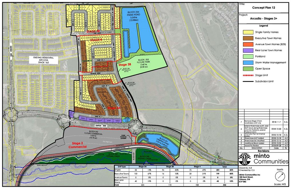
8 The Subject Property is abutting the future Campeau Drive extension which the Official Plan defines as an Arterial Road. This Arterial Road will provide access to both the Terry Fox and Huntmar Drive 417 interchanges. The subdivision is to be developed in a manner that respects the City's Official Plan, the Transportation Master Plan and the Kanata West Transportation Plan. With respect to access to public transit services, the Subject Property includes a block that will form a part of the future Transitway Corridor (shown on Figure 2) and the subdivision has been designed to provide lands for the corridor and access to both the future and existing transit network. 2.0 THE PROPOSAL 2.1 Existing Draft Plan of Subdivision Application Appendix A is a reduced copy of the latest update to the conceptual Subdivision Plan for the proposed development. Stages 3 & 4 of the proposed development includes 201 single units, 199 executive towns units, and 42 rear lane townhome units totaling 442 units. These Stages will also include: nine (9) local streets; one (1) park block; three (3) stormwater blocks; and one (1) commercial block. The Subject Property will be serviced by municipal water services and municipal sanitary sewers. Blocks 253, 254 and 255 will be used for the establishment of stormwater ponds to serve the entire subdivision, the LRT and Campeau Drive. Municipal water, sanitary sewer and stormwater sewer services are available in Campeau Drive, Paine Avenue, Clonrush Way and Calvington Avenue to service the Subject Site. A Site Servicing Plan and report confirming the availability of services accompanies this submission. JLR J.L. Richards & Associates Limited
9 As shown in Appendix A, vehicular access to the Subject Site s internal streets will be from Campeau Drive and connect to both Stages 1 and 2 to allow for an integrated system. 2.2 Zoning By-law Amendment The majority of the Subject Site is currently zoned Development Reserve Zone (DR) under the City of Ottawa Zoning By-law ( Consolidation). The purpose of the DR Zone is to: recognize lands intended for future urban development in areas designated as General Urban Area and Developing Communities in the Official Plan. The purpose of the EP Zone is to recognize lands which are designated in the Official Plan as Significant wetlands, Natural Environment Areas and Urban Natural Features that contain important environmental resources which must be protected for ecological, educational and recreational reasons. Current permitted uses in the DR Zone are limited to agricultural use, community garden, emergency service, environmental preserve and education area, forestry operation, group home, home-based business, marine facility, detached dwelling accessory to a permitted use, park and a secondary dwelling unit. A portion of these lands is also zoned Open Space (O1) and (O1[1932]-h), Development Reserve Zone (DR [1932]-h) and Development Reserve Zone (DR [2492]-h. These exceptions deal with the Carp River Restoration Project and the Feedmill Creek Corridor. A part of the site is also shown as Floodplain overlay. This reflects the area prior to the restoration works. A portion of the property was pre-zoned to R4Z [1887] and R3YY [1886] for the Stage 3 lands during the rezoning of Stages 1 and 2. As a result of further redesigns of this area, these existing zones are proposed to be amended. A Zoning By-law Amendment is required in order to proceed with the development of these lands in accordance with the land use designations established in the OP and as shown on the Draft Plan of Subdivision. JLR J.L. Richards & Associates Limited
10 The Zoning By-law Amendment seeks to change the current zoning of Development Reserve Zone to Residential Third Density Subzone YY Urban Exception xxxx (R3YY [xxxx]) for the proposed residential development as shown in Figure 3. Figure 3 Proposed Zoning By-law Schedule The proposed Residential Third Density Subzone YY (R3YY) will allow for the development of a range of low and medium density residential building forms including the proposed singles, townhomes, back-to-back townhomes and the rear yard townhomes. The YY subzone is used for residential development primarily within Developing Communities throughout the City to promote efficient land use and compact form while showcasing newer design approaches. The proposed Urban Exception will allow for the zoning standards established in Stages 1 and 2 of the Subdivision. The proposed wording for the Urban Exception is as follows: JLR J.L. Richards & Associates Limited
11 - the following provisions apply to a detached dwelling: (i) minimum front yard setback: 3.75 m (ii) minimum corner side yard setback: 2.5 m - for a detached dwelling located on a corner lot with a driveway providing access over an exterior side lot line: (i) minimum front yard setback: 2.6 m (ii) minimum corner side yard setback: 1.2 m - the following provisions apply to a semi-detached dwelling: (i) minimum lot width: 6.5 m (ii) minimum lot area: 170 m2 (iii) minimum front yard setback: 3.75 m (iv) minimum corner side yard setback: 2.5 m - the following provisions apply to a townhouse dwelling: (i) minimum lot width: 4 m (ii) minimum lot area: 95 m2 (iii) minimum front yard setback: 2 m (iv) minimum corner side yard setback: 2.5 m (v) minimum rear yard setback: 4.7 m (vi) Section 135 does not apply - for townhouse dwellings where the dwellings are arranged both side-by-side and back-to-back: (i) the maximum number of dwelling units permitted within a townhouse dwelling is 12; however, no more than 6 units may be located side-by-side (ii) minimum lot area: 80 m 2 (iii) minimum corner side yard setback: 2.5 m (iv) there is no rear yard setback requirement (v) minimum front yard setback: 5 m - where a corner lot contains a single detached dwelling and a parking space is accessed from a driveway located in the front yard, a maximum of 65 per cent of the area of the front yard, may be used for a driveway, and the remainder of the front yard, except for areas occupied by projections permitted under Section 65, must be landscaped with soft landscaping JLR J.L. Richards & Associates Limited

12 - where a lot contains a townhouse dwelling and a parking space is accessed from a driveway within the front yard, a maximum of 55 percent of the area of the front yard, or the required minimum width of one parking space, whichever is the greater, may be used for a driveway, and the remainder of the front yard, except for areas occupied by projections permitted under Section 65, must be landscaped with soft landscaping - where a lot contains a townhouse dwelling and a parking space is accessed from a driveway within the rear yard, a maximum of 90 percent of the area of the rear yard, or the required minimum width of one parking space, whichever is the greater, may be used for a driveway, and the remainder of the rear yard, except for areas occupied by projections permitted under Section 65, must be landscaped with soft landscaping - despite clause 59(1)(b), access to a lot may be provided by means of a rear lane a minimum of 8.5 metres in width instead of by a public street In order to allow for full driveway access to the proposed double car garages for the rear lane townhouse models, we are requesting that the maximum area for a rear yard driveway be 90 percent of the rear yard. This is demonstrated for the lotting of units on Block 209 of the Draft Plan. Figure 4 Proposed Units and Driveways for Block 209 JLR J.L. Richards & Associates Limited

13 In order to allow for full driveway access to Minto s larger single detached corner lot models, which have their main building face fronting the exterior side lot line and their double garages facing the front lot line, we are requesting that the maximum area for a driveway located in the front yard be 65 percent of the front yard. This is demonstrated by the dwelling placement on Lot 165 of the Draft Plan. With the removal of the sight line triangle from the front yard area calculation, the driveways to Minto s preferred model for corner lot models cannot conform to the current maximum of 50 percent of the yard. This has been the subject of review by the Committee of Adjustment and has been supported. Figure 5 Proposed Unit and Driveway for Lot 165 In order to allow for full driveway access to Minto s townhouse, we are also requesting that the maximum area for a driveway located in the front yard be 55 percent of the front yard. This is demonstrated by the dwelling placement on Block 218 of the Draft Plan. JLR J.L. Richards & Associates Limited

14 Figure 6 Proposed Unit and Driveway for Block 218 The models proposed by Minto for these Stages appear to conform to the provisions of Section 65 regarding the allowance for covered or uncovered balconies, porches, decks, platforms and verandahs, with a maximum of two enclosed sides. The Zoning By-law Amendment also seeks to change the current zoning of Development Reserve Zone to Mixed Use Centre with a maximum height of 45 metres (MC H(45)) for the proposed commercial development as shown in Figure 3. The proposed Mixed Use Centre with a maximum height of 45 metres (MC H(45)) will allow for the development of a broad range of uses including retail, service commercial, offices, residential and institutional uses in mixed-use buildings. This proposed zoning and subsequent height limit is consistent with the existing commercially zoned parcel in Stage 1 and the policies of the Mixed Use Centre designation. Similarly, the property includes an area that is subject to the current Carp River Restoration Policy Area (refer to Figure 7) and an area recently identified by the Mississippi Valley Conservation (MVC) as Feedmill Creek Floodplain. Both of these areas are subject to Conservation Authority Act approvals under Section 28 and are being altered to reflect a future development area that will be implemented as a part of this subdivision and other approvals. The floodplain will be amended to recognize these JLR J.L. Richards & Associates Limited
15 changes in grading that are subject to the MVC Regulations. The lands that are within the area to be filled have been shown as an area where a holding symbol will be applied. This wording for this holding symbol has been implemented by the City in Urban Exceptions 1932 and The lands south of Campeau Drive which are located within the area identified by MVC as Feedmill Creek Floodplain were zoned with a holding symbol by By-law , which is detailed in Exception The wording for this holding provision matches this intent as follows: - Construction of buildings is not permitted until the holding symbol has been removed - the holding symbol may not be removed until the following requirements have been met: a) A corridor along Feedmill Creek has been defined in accordance with Appendix B (Corridor Width Limits Rationale) in the Implementation Plan Kanata West Development Area report as approved by the City of Ottawa and the Mississippi Valley Conservation Authority; b) Mississippi Valley Conservation Authority has issued a permit under Section 28 of the Conservation Authorities Act for the placement and removal of fill in accordance with the Carp River Restoration Plan and the approved Feedmill Creek corridor; and c) Filling of the property and an as-built survey have been completed to demonstrate that the filling outside of the Feedmill Creek and Carp River Corridor limits is completed to the satisfaction of the Mississippi Valley Conservation Authority. We propose this same Exception be placed on the Commercial and Open Space lands south of Campeau Drive, which are currently subject to the holding provision. As the holding symbol restricts development until filling of the property has been certified, the City did not include these lands within the Floodplain Overlay. Inclusion within the Floodplain Overlay would have prevented filling of these lands. The lands north of Campeau Drive, which are located within the area identified by the City s Floodplain Overlay and by MVC as Carp River Floodplain, were zoned with a holding symbol which is detailed in Exception The wording for the holding provision is as follows: JLR J.L. Richards & Associates Limited
16 - the holding symbol can be removed only at such time as the following conditions are met: a. The Minister of the Environment will have approved the Carp River, Pool Creek and Feedmill Creek Restoration Class EA; b. The Kanata West Landowners Group, or the City, will have commenced Phase I of the Carp River restoration works; c. Mississippi Valley Conservation Authority will have issued a permit under Section 28 of the Conservation Authorities Act for the placement and removal of fill in accordance with the Carp River Restoration Plan and the EA; d. Filling of the property and an as-built survey will have been completed to demonstrate that the area is entirely removed from the flood plain; and e. At all times, the flood storage capacity of the corridor will be maintained at or above existing conditions. We propose this same Exception clause be placed on the R3YY and Open Space lands north of Campeau Drive, which are currently subject to the holding provision. As the alteration of the floodplain is under the review of the Conservation Authority and the holding symbol restricts development until filling of the property is certified, we request that the City remove these lands from the Floodplain Overlay. Inclusion within the Floodplain Overlay would prevent filling of these lands. JLR J.L. Richards & Associates Limited

17 Figure 7 Kanata West Carp River Monitoring Plan JLR J.L. Richards & Associates Limited
18 2.2.1 Parkland Dedication Requirements As per the City s Parkland Dedication By-law ( ), the minimum parkland conveyance requirement for the proposed Draft Plan is as follows: ha (2.5 acres) for every 300 dwelling units in the development [or 1.47 ha for the proposed 442 dwelling units]. Based on the above, the total minimum parkland conveyance requirement for the proposed Draft Plan is 1.47 ha. The proposed parks, at 2.46 ha total area, will provide for this requirement Minimum Distance Separation (MDS) The objective of Minimum Distance Separation (MDS) Formulae is to minimize nuisance complaints due to odour and thereby reduce potential land use conflicts. MDS is applied in Prime Agricultural Areas and Rural Areas as defined by the Provincial Policy Statement. MDS applies only to livestock facilities. It does not apply to abattoirs, apiaries, assembly yards, fairgrounds, feed storages, field shade shelters, greenhouses, kennels, livestock facilities that are less than 10 m 2 (108 ft 2 ) in floor area, machinery sheds, mushroom farms, pastures, slaughter houses, stockyards, or temporary field nutrient storage sites. There is currently a barn located west of Huntmar Drive directly across from Stage 2 of the Arcadia Subdivision. Based on Stage 2 being located between this barn and Stages 3, 4, 5 and 6, the approval of residential development on these lands will not further impact any existing agricultural operation and meets the required guidelines for MDS. 3.0 POLICY CONTEXT 3.1 Planning Act (R.S.O. 1990, CHAPTER P.13) Section 51 (24) of the Planning Act provides details regarding the criteria to be considered with a Draft Plan of Subdivision application. JLR J.L. Richards & Associates Limited
19 The proposed Draft Plan of Subdivision for Stages 3, 4 and commercial Stage 2 has addressed all of the criteria identified in the Act. The proposed Zoning By-law Amendment will implement this Plan. This rationale confirms our opinion that the proposed Zoning By-law Amendment has met the criteria identified in the Act and is appropriate for development. 3.2 Provincial Policy Statement (2014) This Zoning By-law Amendment is consistent with the vision and ideas of the Provincial Policy Statement (PPS) as issued under Section 3 of the Planning Act. For example, Section 1.1 of the PPS focuses on promoting efficient land use and development patterns that occur adjacent to built-up areas and which provide opportunities for intensification. It is our opinion that this proposal is consistent with the PPS, Please see Appendix B for the detailed review of the relevant PPS policies. 3.3 The City of Ottawa Official Plan The City of Ottawa Official Plan, adopted by City Council in May 2003, has been updated and amended numerous times by both Council and the Ontario Municipal Board. For the purposes of this, the on-line consolidated version of the Official Plan, including Amendment #150 was used as reference. Changes to the Mixed Use Centre introduced by OPA #180 have also been taken into account. The Subject Site is located within the urban boundary of the City of Ottawa and is part of the settlement area for the City. Schedule B of the Official Plan shows the site designated as a General Urban Area and Mixed Use Centre with a Carp River Restoration Policy Area Overlay (refer to Figure 8) within the Urban Area. JLR J.L. Richards & Associates Limited


20 Figure 8 Existing City of Ottawa Official Plan Schedule B The proposed Draft Plan was created with special consideration for the policies of the General Urban Area, Strategic Directions in the Official Plan and based upon the required technical studies, in particular, those related to protection and restoration of the Carp River and achieving an appropriate density for these lands. Please see Appendix C for the detailed review of the relevant Official Plan policies. 3.4 Background Studies The studies that were identified during the pre-consultation meeting with City Staff are being submitted in support of this application. JLR J.L. Richards & Associates Limited
21 4.0 CONCLUSION This Report has been prepared in support of an application for a Zoning By-law Amendment for Stages 3, 4 and commercial Stage 2 in the Arcadia Subdivision, which will see the new development of approximately 442 low and medium density residential dwelling units. 1. The proposed Zoning By-law Amendment is consistent with the Provincial Policy Statement, 2014 as the proposed development is located within a designated Settlement Area, is compatible with its surroundings and is consistent with the provincial interest identified in the Provincial Policy Statement. 2. The application also respects the provisions of the Official Plan which has identified these lands as General Urban and Mixed Use Centre. This proposal conforms to the intent of these designations in that both residential development and mixed use commercial are being proposed. Based on the above noted rationale, the application for Zoning By-law Amendment is appropriate and represents good land use planning. Prepared by: Reviewed by: Katie Morphet, MCIP, RPP Timothy F. Chadder, MCIP, RPP JLR J.L. Richards & Associates Limited
22 A P P E N D I X A REDUCED CONCEPTUAL SUBDIVISION PLAN AND DRAFT PLAN
23
24 A P P E N D I X B REVIEW OF PROVINCIAL POLICY STATEMENT (2014)
25 Provincial Policy Statement (2014) This Zoning By-law Amendment to implement the proposed Draft Plan of Subdivision is consistent with the vision and ideas of the Provincial Policy Statement (PPS) as issued under Section 3 of the Planning Act. Section 1.1 of the PPS focuses on promoting efficient land use and development patterns that occur adjacent to built-up areas and which provide opportunities for intensification. Section states: Settlement Areas shall be the focus of growth and their vitality and regeneration shall be promoted. The proposed development of the Subject Site promotes growth within the Kanata West community by adding 672 residential units. The proposed residential and mixed use commercial development is a logical and anticipated extension of the surrounding neighbourhoods and will foster fluid connections within the community. Section of the Provincial Policy Statement states: Land use patterns within settlement areas shall be based on: a) densities and a mix of land uses which: 1. efficiently use land and resources; 2. are appropriate for, and efficiently use, the infrastructure and public service facilities which are planned or available, and avoid the need for unjustified and/or uneconomical expansion; Section of the Provincial Policy Statement states: New development taking place in designated growth area should occur adjacent to the existing built-up area and shall have a compact form, mix of uses and densities that allow for the efficient use of land, infrastructure and public service facilities. The PPS promotes the development of areas where infrastructure is already in place. The PPS supports a range of housing types and Section indicates that: Planning authorities shall provide for an appropriate range of housing types and densities to meet projected requirements of current and future residents of the regional market area by: a) establishing and implementing minimum targets for the provision of housing which is affordable to low and moderate income households.; d) promoting densities for new housing which efficiently use land, resources, infrastructure and public service facilities, and support the use of alternative transportation modes and public transit in areas where it exists or is to be developed; The development proposal for Stages 3, 4 and commercial Stage 2 supports the goals of the PPS Section 1.1 as outlined in that it provides mixed density of housing. Existing infrastructure is in place to service the development, and transportation networks have recently been upgraded. The Servicing Brief that has been prepared in support of this application confirms this statement. Further, this proposal will provide a range of housing in keeping with the policies of the PPS.
26 A P P E N D I X C REVIEW OF CITY OF OTTAWA OFFICIAL PLAN (including O.P.A #150 and #180 as approved by Council)
27 City of Ottawa Official Plan, 2003 The City of Ottawa Official Plan, adopted by City Council in May 2003, has been updated and amended numerous times by both Council and the Ontario Municipal Board. For the purposes of this, the on-line consolidated version of the Official Plan, including Amendment #150 was used as a reference. OPA 180 which was completed as a result of a City-wide review of employment lands was also used as part of this review. The Subject Site is located within the urban boundary of the City of Ottawa and is part of the settlement area for the City. Schedule B of the Official Plan shows the site location in the west part of the City of Ottawa designated as General Urban Area and Mixed Use Centre with a Carp River Restoration Policy Area Overlay (refer to Figure 6) within the Urban Area. OPA 150 resulted in a portion of the Mixed Use Centre lands being redesignated to Employments Lands. OPA 180 approved in December 2016 has since redesignated these lands back to Mixed Use Centre. Section of the Official Plan provides a framework for the General Urban Area. The Plan states that: The General Urban Area designation permits the development of a full range and choice of housing types to meet the needs of all ages, incomes and life circumstances, in combination with conveniently located employment, retail, service, cultural, leisure, entertainment and institutional uses. This will facilitate the development of complete and sustainable communities. A broad scale of uses is found within this designation, from ground-oriented single-purpose to multi-storey mixed-use; from corner store to shopping centre. While the City is supportive of the establishment of a broad mix of uses in Ottawa's neighbourhoods, this is not meant to imply that all uses will be permitted everywhere within areas that are designated General Urban Area. The zoning bylaw will continue to regulate the location, scale and type of land use in accordance with the provisions of this Plan. Within neighbourhoods, the zoning by-law will allow those uses that provide for the local, everyday needs of the residents, including shopping, schools, recreation and services. Uses that also serve wider parts of the city will be located at the edges of neighbourhoods on roads where the needs of these land uses (such as transit, car and truck access, and parking) can be more easily met and impacts controlled. Subject to the policies below, the City supports infill development and other intensification within the General Urban Area in a manner that enhances and complements the desirable characteristics and ensures the long-term vitality of the many existing communities that make up the city.
28 Section of the Official Plan provides a framework for Mixed Use Centres and Town Centres. The Plan states that: Town Centres and Mixed Use Centres occupy strategic locations on the Rapid- Transit network and act as central nodes of activity within their surrounding communities and the city as a whole. These centres are a critical element in the City's growth management strategy, being areas with potential to achieve high densities and compact and mixed-use development oriented to rapid transit. More jobs and housing at these locations will increase transit ridership and draw more commuter travel to these locations. In the long term, the centres will become complete, liveable communities that attract people for the jobs, leisure, lifestyle, and business opportunities they provide. Section 3.13 of the Official Plan provides a framework for the Carp River Restoration Policy Area. The Plan states that: Policies 1. Lands in the vicinity of the Carp River between Hazeldean Road and a point north of Campeau Drive, are designated Carp River Restoration Policy Area' on Schedules A and B of this Plan. The Restoration Policy Area is an overlay over urban land-use designations. The extent of the flood plain lands to which the Carp River Restoration Policy Area applies will be determined by the consulting the implementing Zoning By-law and Conservation Authority Flood Plain maps. The purpose of the Restoration Policy Area designation is to recognize that proposed channel modifications and restoration works will occur and allow for development of part of this area following implementation. However, a number of conditions must be met before development is allowed to proceed: Conditions a. The Minister of the Environment will have approved the Carp River, Poole Creek and Feedmill Creek Restoration Class EA; b. The Kanata West Landowners Group, or the City, will have commenced the physical construction of Phase I of the Carp River restoration works; c. Mississippi Valley Conservation Authority will have issued a permit under Section 28 of the Conservation Authorities Act for the placement and removal of fill in accordance with the Carp River Restoration Plan and the EA; d. Filling of the property and an as-built survey will have been completed to demonstrate that the area is entirely removed from the flood plain; and e. At all times, the flood storage capacity of the corridor will be maintained at or above existing conditions.
29 2. Once all five conditions have been met, the Zoning By-law may be amended (holding provision lifted) on the basis of the underlying designation on these lands. An Official Plan Amendment will not be required to revert to the underlying designation provided the conditions listed in B policy 1 have been met. The proposed Draft Plan was created with special consideration for the policies of the General Urban Area, Mixed Use Centre, ongoing Carp River Restoration works, and based upon the required technical studies. The proposed zoning is the proper reflection of these policies as refined in the supporting studies.
178 Carruthers Properties Inc.
 178 Carruthers Properties Inc. Planning Rationale for 178 Carruthers Avenue Site Plan Control Application June 2014 Table of Contents 1.0 Introduction 2.0 Overview of Subject Property 3.0 Current Zoning
KANATA CENTRUM 255 KANATA AVENUE OFFICIAL PLAN AMENDMENT ZONING BY-LAW AMENDMENT
 KANATA CENTRUM 255 KANATA AVENUE OFFICIAL PLAN AMENDMENT ZONING BY-LAW AMENDMENT JUNE 2015 PREPARED BY: FOTENN Consultants Inc. 223 Mcleod Street Ottawa, ON K2P OZ8 (613) 730-5709 PREPARED FOR: Kanata
ONTARIO MUNICIPAL BOARD
 PL 120483 ONTARIO MUNICIPAL BOARD Applicant/Appellant: 2124123 Ontario Limited Subject: OPA, Rezoning and Draft Plan of Subdivision Municipal Address: 3940 Highway 7 East Municipality: City of Markham
URBANDALE CONSTRUCTION PHASE 4B 4450 LIMEBANK ROAD PLANNING RATIONALE FOR SITE PLAN CONTROL. May Prepared for:
 URBANDALE CONSTRUCTION PHASE 4B 4450 LIMEBANK ROAD PLANNING RATIONALE FOR SITE PLAN CONTROL Prepared for: URBANDALE CONSTUCTION 2193 Arch Street Ottawa, Ontario K1G 2H5 Prepared by: J.L. RICHARDS & ASSOCIATES
2136 & 2148 Trafalgar Road Town of Oakville Region of Halton
 PLANNING JUSTIFICATION REPORT 2136 & 2148 Trafalgar Road Town of Oakville Region of Halton Zoning By-Law Amendment Application 2500674 Ontario Inc. November 2016 Table of Contents Page 1.0 Location/Summary
KANATA WEST BUSINESS PARK. Subdivision, Official Plan Amendment & Zoning By-law Amendment. Planning Rationale
 KANATA WEST BUSINESS PARK Subdivision, Official Plan Amendment & Zoning By-law Amendment Planning Rationale February 2014 PREPARED BY: FOTENN Consultants Inc. 223 McLeod Street Ottawa, ON K2P 0Z8 613-730-5709
Commercial Development Proposal Tenth Line Road. Planning Rationale Report. Minto Developments Inc.
 Commercial Development Proposal 2168 Tenth Line Road Report September 2015 Prepared for Minto Developments Inc. Paquette Planning Associates Ltd. 56 Hutchison Avenue Ottawa, Ontario K1Y 4A3 PH: 613-722-7217
PORT WHITBY COMMUNITY
 PORT WHITBY COMMUNITY SECONDARY PLAN UPDATE COMMUNITY IMPROVEMENT PLAN URBAN DESIGN GUIDELINES September 2015 DRAFT PROPOSED AMENDMENT NUMBER # to the Whitby Official Plan PURPOSE: The intent of this Amendment
Re: Hazeldean Road - Minto Potters Key Subdivision Responses to Resident Concerns
 November 28, 2015 D07-16-14-0013 Councillor Shad Qadri 110 Laurier avenue west Ottawa, Ontario K1P 1J1 Dear Councillor Qadri, Re: 6111 6141 Hazeldean Road - Minto Potters Key Subdivision Responses to Resident
Design Brief and Planning Rationale. for Site Plan Control Application. Harmony Subdivision, Stage 1, Block 104
 Design Brief and Planning Rationale for Site Plan Control Application Harmony Subdivision, Stage 1, Block 104 4025 Strandherd Drive, Minto Communities Inc. Prepared By: NOVATECH Suite 200, 240 Michael
Planning Rationale Fernbank Road, Ottawa. Major Zoning By-law Amendment and Site Plan Control Application Ontario Inc.
 Planning Rationale Major Zoning By-law Amendment and Site Plan Control Application 5264 Fernbank Road, Ottawa 1872089 Ontario Inc. March 2014 Planning Rationale Major Zoning By-law Amendment and Site Plan
PLANNING RATIONALE FOR 1127, 1128 MILL STREET AND 1125 CLAPP LANE CITY OF OTTAWA
 PLANNING RATIONALE FOR 1127, 1128 MILL STREET AND 1125 CLAPP LANE CITY OF OTTAWA Prepared by: Realty Initiatives and Development On behalf of the Manotick Mill Community Lands Development Corporation March
FORMER CANADIAN FORCES BASE (CFB) ROCKCLIFFE SECONDARY PLAN. Official Plan Amendment XX to the Official Plan for the City of Ottawa
 ROCKCLIFFE SECONDARY PLAN. Official Plan Amendment XX to the Official Plan for the City of Ottawa") FORMER CANADIAN FORCES BASE (CFB) ROCKCLIFFE SECONDARY PLAN Official Plan Amendment XX to the Official Plan for the City of Ottawa 1 INDEX THE STATEMENT OF COMPONENTS PART A THE PREAMBLE PAGE Purpose...
FORMER CANADIAN FORCES BASE (CFB) ROCKCLIFFE SECONDARY PLAN Official Plan Amendment XX to the Official Plan for the City of Ottawa 1 INDEX THE STATEMENT OF COMPONENTS PART A THE PREAMBLE PAGE Purpose...
Report Regarding Site Plan Control for 55 Wellspring Way (File No. SP-06-16)
") Report Regarding Site Plan Control for 55 Wellspring Way (File No. SP-06-16) Executive Summary: The purpose of this report is to provide Council with information regarding site plan control under Section
Report Regarding Site Plan Control for 55 Wellspring Way (File No. SP-06-16) Executive Summary: The purpose of this report is to provide Council with information regarding site plan control under Section
[PLANNING RATIONALE] For Site Plan Control and Lifting of Holding Zone By-Law 101 Champagne Avenue. May 23, 2014
![[PLANNING RATIONALE] For Site Plan Control and Lifting of Holding Zone By-Law 101 Champagne Avenue. May 23, 2014](/thumbs/75/71599615.jpg "[PLANNING RATIONALE] For Site Plan Control and Lifting of Holding Zone By-Law 101 Champagne Avenue. May 23, 2014") [PLANNING RATIONALE] For Site Plan Control and Lifting of Holding Zone By-Law 101 Champagne Avenue May 23, 2014 Contents 1.0 Introduction... 2 2.0 Site Context... 2 2.1 Adjacent Uses... 2 Figure 1: Site
[PLANNING RATIONALE] For Site Plan Control and Lifting of Holding Zone By-Law 101 Champagne Avenue May 23, 2014 Contents 1.0 Introduction... 2 2.0 Site Context... 2 2.1 Adjacent Uses... 2 Figure 1: Site
RIVERSIDE SOUTH DEVELOPMENT PHASE 8 (980 Earl Armstrong Road) REVISED PLANNING RATIONALE FOR ZONING BY-LAW AMENDMENT (D# )
 REVISED PLANNING RATIONALE FOR ZONING BY-LAW AMENDMENT (D# )") RIVERSIDE SOUTH DEVELOPMENT PHASE 8 (980 Earl Armstrong Road) REVISED PLANNING RATIONALE FOR ZONING BY-LAW AMENDMENT (D#02-02-09-0060) July 2009 Revised August 2015 Prepared for: RIVERSIDE SOUTH DEVELOPMENT
RIVERSIDE SOUTH DEVELOPMENT PHASE 8 (980 Earl Armstrong Road) REVISED PLANNING RATIONALE FOR ZONING BY-LAW AMENDMENT (D#02-02-09-0060) July 2009 Revised August 2015 Prepared for: RIVERSIDE SOUTH DEVELOPMENT
A Growing Community Rural Settlement Areas
 Town of Huntsville Official Plan Review - POLICY BACKGROUND PAPER A Growing Community Rural Settlement Areas BACKGROUND: In addition to the fully municipally-serviced Urban Settlement Area and the Hidden
Public Storage Self-storage Facility (Warehouse)
") Public Storage Self-storage Facility (Warehouse) 3545 St. Joseph Boulevard Planning Rationale PREPARED FOR: Maple Reinders Constructors Ltd. 2660 Argentia Road Mississauga, Ontario L5N 5V4 PREPARED BY:
Public Storage Self-storage Facility (Warehouse) 3545 St. Joseph Boulevard Planning Rationale PREPARED FOR: Maple Reinders Constructors Ltd. 2660 Argentia Road Mississauga, Ontario L5N 5V4 PREPARED BY:
Planning Primer Legislative Background, Policy Documents and Development Review Processes. Presented by: Planning Services Date: April 6, 2017
 Planning Primer Legislative Background, Policy Documents and Development Review Processes Presented by: Planning Services Date: April 6, 2017 Agenda Legislative Background 7:30 to 8:00 pm Questions 8:00
8 Oak Street - Official Plan and Zoning By-law Amendment Application - Preliminary Report
 STAFF REPORT ACTION REQUIRED 8 Oak Street - Official Plan and Zoning By-law Amendment Application - Preliminary Report Date: March 17, 2014 To: From: Wards: Reference Number: Planning and Growth Management
1120 Haist Street - Pelham Arena Community Co-Design Recommendation Report Haist Street - Pelham Arena Community Co-Design Recommendation Report
 1120 Haist Street - Pelham Arena Community Co-Design Executive Summary: In May, 2017 the Town retained the services of The Planning Partnership to undertake a community design charrette process to determine
20 & 30 Frank Nighbor Place
 Engineering Land / Site Development Municipal Infrastructure Environmental / Water Resources Traffic / Transportation Structural Recreational Planning Land / Site Development Planning Application Management
9 CITY OF VAUGHAN OFFICIAL PLAN AMENDMENT NO BOCA EAST INVESTMENTS LIMITED
 9 CITY OF VAUGHAN OFFICIAL PLAN AMENDMENT NO. 631 - BOCA EAST INVESTMENTS LIMITED The Planning and Economic Development Committee recommends the adoption of the recommendations contained in the following
Lacolle Way. Planning Rationale. Zoning By-law Amendment Site Plan Control. November 17, 2016
 571 Lacolle Way Planning Rationale Zoning By-law Amendment Site Plan Control November 17, 2016 Prepared By: FOTENN Consultants Inc. 223 McLeod Street Ottawa, ON K2P 0Z8 www.fotenn.com 613.730.5709 TABLE
141 GEORGE STREET PLANNING RATIONALE
 141 GEORGE STREET PLANNING RATIONALE MINOR ZONING BY-LAW AMENDMENT NOVEMBER 2, 2016 PLANNING RATIONALE 223 McLeod Street Ottawa, ON K2P 0Z8 613.730.5709 fotenn.com INTRODUCTION FOTENN Consultants is acting
4780 Eglinton Avenue West - Zoning By-law Amendment and Draft Plan of Subdivision Applications - Preliminary Report
 STAFF REPORT ACTION REQUIRED 4780 Eglinton Avenue West - Zoning By-law Amendment and Draft Plan of Subdivision Applications - Preliminary Report Date: May 29, 2014 To: From: Wards: Reference Number: Etobicoke
LAND USE AMENDMENT CORNERSTONE (WARD 3) 60 STREET NE AND COUNTRY HILLS BOULEVARD NE MAP 26NE BYLAW 22D2017
 60 STREET NE AND COUNTRY HILLS BOULEVARD NE MAP 26NE BYLAW 22D2017") Page 1 of 14 EXECUTIVE SUMMARY This Land Use Amendment application covers an area of 43.76 hectares ± (108.14 acres ±) located in northeast Calgary, bound by Country Hills Boulevard NE to the south and
Page 1 of 14 EXECUTIVE SUMMARY This Land Use Amendment application covers an area of 43.76 hectares ± (108.14 acres ±) located in northeast Calgary, bound by Country Hills Boulevard NE to the south and
Figure 1- Site Plan Concept
 Figure 1- Site Plan Concept Parking will be provided underground on three levels at rate of 1.0 space/ unit; this rate includes all visitors parking. MMM Group has prepared a parking assessment (April,
The Corporation of the TOWN OF MILTON
 Report to: From: Chair & Members of the Administration & Planning Standing Committee W.F. Mann, Director of Planning and Development Date: April 16, 2012 PD 022-12 (Z19/11) Subject: Technical Report Proposed
ELMVALE ACRES SHOPPING CENTRE MASTER PLAN
 ELMVALE ACRES SHOPPING CENTRE MASTER PLAN Contents 1.0 INTRODUCTION... 2 2.0 LOCATION... 2 3.0 EXISTING CONTEXT... 2 4.0 VISION & GUIDING PRINCIPLES... 2 5.0 LAND USE AND BUILT FORM... 4 5.1 St. Laurent
Official Plan Review
 Official Plan Review Summary Report - The Built Environment August 2014 Part 1: Introduction Planning for a healthy, prosperous and sustainable community is an important goal for our municipality. From
10 COPE DRIVE. May 08, 2018 Planning Rationale and Design Brief. Site Plan Control
 10 COPE DRIVE May 08, 2018 Planning Rationale and Design Brief Site Plan Control Prepared for: Taggart Realty Management 225 Metcalfe Street, Suite 708 Ottawa, ON K2P 1P9 taggart.ca Prepared by: Fotenn
ROAD CLOSURE AND LAND USE AMENDMENT SILVER SPRINGS (WARD 1) NORTHEAST OF NOSEHILL DRIVE NW AND SILVER SPRINGS ROAD NW BYLAWS 2C2018 AND 29D2018
 NORTHEAST OF NOSEHILL DRIVE NW AND SILVER SPRINGS ROAD NW BYLAWS 2C2018 AND 29D2018") Page 1 of 19 EXECUTIVE SUMMARY This application proposes redesignating two parcels in the community of Silver Springs from Special Purpose Future Urban Development (S-FUD) District and undesignated road
Page 1 of 19 EXECUTIVE SUMMARY This application proposes redesignating two parcels in the community of Silver Springs from Special Purpose Future Urban Development (S-FUD) District and undesignated road
Growing Community Urban Settlement Area and Hidden Valley Settlement Area
 Town of Huntsville Official Plan Review - POLICY BACKGROUND PAPER Growing Community Urban Settlement Area and Hidden Valley Settlement Area BACKGROUND: Through the Provincial Policy Statement (PPS), the
URBAN DESIGN BRIEF. 2136&2148 Trafalgar Road. Town of Oakville
 URBAN DESIGN BRIEF 2136&2148 Trafalgar Road Town of Oakville Prepared By: METROPOLITAN CONSULTING INC For 2500674 Ontario Inc November 2016 TABLE OF CONTENTS Page No. 1.0 Introduction/Description of Subject
AGINCOURT SECONDARY PLAN
 1 AGINCOURT SECONDARY PLAN 1. AGINCOURT SECONDARY PLAN The following policies and principles apply to the area herein referred to as Agincourt, as outlined on Map 1-1. 1. GENERAL POLICIES 1.1 This Secondary
Draft Urban Hamilton Official Plan. Amendment No. XX
 1 of 75 The following text, together with: Draft Appendix A Appendix B Volume 1, Schedule E-1 Urban Land Use Designations Appendix C Volume 1, Appendix A Parks Classification Map Appendix D Volume 1, Appendix
POLICY AMENDMENT AND LAND USE AMENDMENT TUXEDO PARK (WARD 9) CENTRE STREET N AND 26 AVENUE NE BYLAWS 36P2017 AND 234D2017
 CENTRE STREET N AND 26 AVENUE NE BYLAWS 36P2017 AND 234D2017") Page 1 of 11 EXECUTIVE SUMMARY This application proposes to redesignate a single parcel of land in the Community of Tuxedo Park from Commercial Corridor 2 (C-COR2 f1h10) District to Mixed Use Active Frontage
Page 1 of 11 EXECUTIVE SUMMARY This application proposes to redesignate a single parcel of land in the Community of Tuxedo Park from Commercial Corridor 2 (C-COR2 f1h10) District to Mixed Use Active Frontage
Bressa Developments Limited. Planning Justification Report. Revised Draft Plan of Subdivision and Zoning By-Law Amendment
 Bressa Developments Limited Revised Draft Plan of Subdivision and Zoning By-Law Amendment Planning Justification Report Part of Lots 7 & 8 Concession 1, North of Dundas Street Town of Oakville September,
Greystone Village Main Street. Terraces at Greystone. City of Ottawa. Planning Rationale
 Greystone Village - 175 Main Street Terraces at Greystone City of Ottawa Planning Rationale Prepared By: NOVATECH Suite 200, 240 Michael Cowpland Drive Ottawa, Ontario K2M 1P6 August / 7 / 2015 Novatech
AREASTRUCTURE PLAN AMENDMENT COCHRANE NORTH
 AREASTRUCTURE PLAN AMENDMENT COCHRANE NORTH In order to implement the vision outlined in the Conceptual Scheme, the following three amendments to the Cochrane North ASP are proposed: 1. Allow commercial
and Richmond Street West - Official Plan Amendment Application - Preliminary Report
 STAFF REPORT ACTION REQUIRED 822-838 and 860-862 Richmond Street West - Official Plan Amendment Application - Preliminary Report Date: August 14, 2017 To: From: Wards: Reference Number: Toronto and East
3 TOWN OF WHITCHURCH-STOUFFVILLE OFFICIAL PLAN AMENDMENT NOS. 116 & 117
 3 TOWN OF WHITCHURCH-STOUFFVILLE OFFICIAL PLAN AMENDMENT NOS. 116 & 117 The Planning and Economic Development Committee recommends the adoption of the recommendations contained in the following report,
2983 NAVAN ROAD ZONING BY-LAW AMENDMENT
 2983 NAVAN ROAD ZONING BY-LAW AMENDMENT June 29, 2018 Planning Rationale Zoning By-law Amendment Prepared for: Taggart Realty Management 225 Metcalfe, Suite 708 Ottawa, ON, K2P 1P9 taggart.ca Prepared
12 AMENDMENT NO. 149, TOWN OF MARKHAM HIGHWAY 404 NORTH SECONDARY PLAN
 12 AMENDMENT NO. 149, TOWN OF MARKHAM HIGHWAY 404 NORTH SECONDARY PLAN The Planning and Economic Development Committee recommends the adoption of the recommendation contained in the following report August
MEADOWGLEN DR. ORLEANS. Zoning By-Law Amendment Application November 2012
 5911 MEADOWGLEN DR. ORLEANS Zoning By-Law Amendment Application November 2012 Prepared by: 223 McLeod Street Ottawa, ON K2P 0Z8 T: 613.730.5709 ext.238 F: 613.730.1136 Prepared for: 371A Richmond Road,
URBAN DESIGN BRIEF URBAN DESIGN BRIEF 721 FRANKLIN BLVD, CAMBRIDGE August 2018
 URBAN DESIGN BRIEF URBAN DESIGN BRIEF 721 FRANKLIN BLVD, CAMBRIDGE August 2018 DESIGN BRIEF CONTENTS PART A 1.0 INTRODUCTION 2.0 DESCRIPTION & ANALYSIS OF SITE CONTEXT 3.0 DESIGN CONSTRAINTS AND OPPORTUNITIES
PLANNING RATIONALE 3843 INNES ROAD, ORLEANS 78 UNITS CONDOMINIUM PROJECT MELKART DEVELOPMENTS Inc.
 78 UNITS CONDOMINIUM PROJECT MELKART DEVELOPMENTS Inc. 2 PLANNING RATIONALE 78 UNITS CONDOMINIUM PROJECT Proposed at 3843 Innes Road Orleans, Ontario Report Prepared for: Melkart Developments Inc. 3497
The West Vaughan Employment Area Secondary Plan Policies
 Part 2: The West Vaughan Employment Area Secondary Plan Policies 2.1 General Policies It is the policy of Council: 2.1.1. That the West Vaughan Employment Area (the WVEA), identified on Schedule 1, will
URBAN DESIGN BRIEF Gordon Street City of Guelph. Prepared on behalf of Ontario Inc. March 25, Project No. 1507
 URBAN DESIGN BRIEF 1131 Gordon Street City of Guelph Prepared on behalf of 1876698 Ontario Inc. March 25, 2016 Project No. 1507 423 Woolwich Street, Suite 201, Guelph, Ontario, N1H 3X3 Phone (519) 836-7526
Planning and Growth Management Committee. Chief Planner and Executive Director, City Planning Division. Pg12013 (File No NNY 34 OZ)
") 865 York Mills Road Official Plan Amendment Application Preliminary Report STAFF REPORT ACTION REQUIRED Date: February 28, 2012 To: From: Wards: Reference Number: Planning and Growth Management Committee
865 York Mills Road Official Plan Amendment Application Preliminary Report STAFF REPORT ACTION REQUIRED Date: February 28, 2012 To: From: Wards: Reference Number: Planning and Growth Management Committee
PLANNING JUSTIFICATION REPORT
 PLANNING JUSTIFICATION REPORT 55 DELHI STREET CITY OF GUELPH PREPARED FOR: VESTERRA PROPERTY MANAGEMENT PREPARED BY: LABRECHE PATTERSON & ASSOCIATES INC. SCOTT PATTERSON, BA, CPT, MCIP, RPP PRINCIPAL,
TABLE OF CONTENTS 1.0 INTRODUCTION... 3
 TABLE OF CONTENTS 1.0 INTRODUCTION... 3 1.1. BACKGROUND... 3 1.2. THE PROPOSAL... 5 2.0 EXISTING POLICY FRAMEWORK... 5 2.1. PROVINCIAL POLICY STATEMENT (PPS)... 5 2.2. CITY OF LONDON OFFICIAL PLAN (OP)...
Foster Creek West Clarington, Ontario PLANNING JUSTIFICATION REPORT
 Foster Creek West Clarington, Ontario PLANNING JUSTIFICATION REPORT Official Plan Amendment Zoning By-law Amendment Neighbourhood Design Plan Amendment Draft Plan of Subdivision File No. 112092 February
EXECUTIVE SUMMARY. 1. Introduction
 EXECUTIVE SUMMARY 1. Introduction 1.1 Background In the past few years, Ottawa s high technology community has presented the region with a tremendous opportunity to grow and flourish. While high technology
and services The protection and conservation of environmentally significant and sensitive natural heritage features and functions.
 6. Land Use 6.0 Preamble A healthy and livable city is one in which people can enjoy a vibrant economy and a sustainable healthy environment in safe, caring and diverse neighbourhoods. In order to ensure
Revised Planning Rationale in Support of an Application for Site Plan Control Leitrim Road City of Ottawa
 Revised Planning Rationale in Support of an Application for Site Plan Control 2644-2670 Leitrim Road City of Ottawa Prepared by: Holzman Consultants Inc. Land Development Consultants October 24, 2017 TABLE
POLICY AMENDMENT AND LAND USE AMENDMENT KILLARNEY/GLENGARRY (WARD 8) NW CORNER OF RICHMOND ROAD AND 33 STREET SW BYLAWS 1P2015 AND 7D2015
 NW CORNER OF RICHMOND ROAD AND 33 STREET SW BYLAWS 1P2015 AND 7D2015") Page 1 of 13 EXECUTIVE SUMMARY This application seeks to redesignate an RC-2 (Residential Contextual One/Two Dwelling) parcel to MC-Gd72 (Multi-Residential Contextual Grade-Oriented) to allow for multi-residential
Page 1 of 13 EXECUTIVE SUMMARY This application seeks to redesignate an RC-2 (Residential Contextual One/Two Dwelling) parcel to MC-Gd72 (Multi-Residential Contextual Grade-Oriented) to allow for multi-residential
Re: 1110 Fisher Avenue Proposed Residential Development Revised Proposal File D PLANNING RATIONALE ADDENDUM
 October 23, 2014 Prestige Design & Construction 50 Camelot Drive Ottawa, ON K2G 5X8 Attention: Mr. Enzo DiChiara Dear Mr. DiChiara Re: 1110 Fisher Avenue Proposed Residential Development Revised Proposal
SUBJECT: Proposed Downtown Mobility Hub Precinct Plan and Proposed Official Plan Policies
 Page 1 of Report PB-81-17 SUBJECT: Proposed Downtown Mobility Hub Precinct Plan and Proposed Official Plan Policies TO: FROM: Committee of the Whole Planning and Building Department Report Number: PB-81-17
Further input invited as Colchester Growth Strategy nears final phase
 IUE 3 / NOVEMBER 2015 Further input invited as Colchester Growth trategy nears final phase trathcona County is seeking public feedback as it enters the final phase of work on a Growth Management trategy
K. SMART ASSOCIATES LIMITED
 Planning Justification Report Zoning By-Law Amendment 185 King Street North Waterloo, Ontario April 7th, 2017 Project Reference Number 16-245 K. SMART ASSOCIATES LIMITED CONSULTING ENGINEERS AND PLANNERS
7437, 7439 and 7441 Kingston Road - Zoning By-law Amendment and Site Plan Control Applications - Preliminary Report
 STAFF REPORT ACTION REQUIRED 7437, 7439 and 7441 Kingston Road - Zoning By-law Amendment and Site Plan Control Applications - Preliminary Report Date: August 13, 2015 To: From: Wards: Reference Number:
STAFF REPORT. December 20, North York Community Council. Director, Community Planning, North York District
 STAFF REPORT December 20, 2005 To: From: Subject: North York Community Council Director, Community Planning, North York District Preliminary Report Application to Amend the Official Plan and Zoning By-law
13 THORNHILL YONGE STREET STUDY IMPLEMENTATION CITY OF VAUGHAN OPA 669 AND TOWN OF MARKHAM OPA 154
 13 THORNHILL YONGE STREET STUDY IMPLEMENTATION CITY OF VAUGHAN OPA 669 AND TOWN OF MARKHAM OPA 154 The Planning and Economic Development Committee recommends the adoption of the recommendations contained
Mark-up of the effect of the proposed Bronte Village Growth Area OPA No.18 on the text of section 24, Bronte Village, of the Livable Oakville Plan
 Mark-up of the effect of the proposed Bronte Village Growth Area OPA No.18 on the text of section 24, Bronte Village, of the Livable Oakville Plan Notes: This document is provided for information purposes
CHAIR AND MEMBERS PLANNING & ENVIRONMENT COMMITTEE JOHN M. FLEMING MANAGING DIRECTOR, PLANNING AND CITY PLANNER
 TO: FROM: SUBJECT: CHAIR AND MEMBERS PLANNING & ENVIRONMENT COMMITTEE JOHN M. FLEMING MANAGING DIRECTOR, PLANNING AND CITY PLANNER APPLICATION BY: THE CORPORATION OF THE CITY OF LONDON OUTDOOR PATIOS IN
1296 Kennedy Road - Zoning Amendment Application - Preliminary Report
 STAFF REPORT ACTION REQUIRED 1296 Kennedy Road - Zoning Amendment Application - Preliminary Report Date: January 15, 2016 To: From: Wards: Reference Number: Scarborough Community Council Acting Director,
8 & 10 Donalda Crescent Official Plan & Rezoning Application Final Report
 STAFF REPORT ACTION REQUIRED 8 & 10 Donalda Crescent Official Plan & Rezoning Application Final Report Date: July 26, 2010 To: From: Wards: Reference Number: Scarborough Community Council Director, Community
240 and 242 Finch Avenue West Zoning By-law Amendment Application Preliminary Report
 REPORT FOR ACTION 240 and 242 Finch Avenue West Zoning By-law Amendment Application Preliminary Report Date: March 1, 2019 To: North York Community Council From: Director, Community Planning, North York
11. BALLANTRAE-MUSSELMAN LAKE AND ENVIRONS SECONDARY PLAN
 11. BALLANTRAE-MUSSELMAN LAKE AND ENVIRONS SECONDARY PLAN 11.1 PURPOSE The Ballantrae-Musselman Lake and Environs Secondary Plan Area includes two small existing settlement areas, Ballantrae and Musselman
HURON COMMUNITY PLAN
 CITY OF KITCHENER DEPARTMENT OF DEVELOPMENT AND TECHNICAL SERVICES PD 94/7 HURON COMMUNITY PLAN Recommended by Planning and Economic Development Committee: October 31, 1994 Adopted by Kitchener City Council:
6 CATHEDRAL COMMUNITY SECONDARY PLAN OFFICIAL PLAN AMENDMENT 123 TOWN OF MARKHAM
 6 CATHEDRAL COMMUNITY SECONDARY PLAN OFFICIAL PLAN AMENDMENT 123 TOWN OF MARKHAM The Planning and Economic Development Committee recommends the adoption of the recommendation contained in the following
THE CORPORATION OF THE TOWN OF OAKVILLE BY-LAW NUMBER
 THE CORPORATION OF THE TOWN OF OAKVILLE BY-LAW NUMBER 2017-120 A by-law to adopt an amendment to the Livable Oakville Plan, Official Plan Amendment Number 20 (Downtown Oakville Growth Area) WHEREAS the
From: Director, Community Planning, Scarborough District. Ward 40 Scarborough-Agincourt
 STAFF REPORT ACTION REQUIRED 2967 Sheppard Ave E - Zoning Amendment Application - Preliminary Report Date: July 18, 2014 To: Scarborough Community Council From: Director, Community Planning, Scarborough
YONGE STEELES CORRIDOR SECONDARY PLAN. Young + Wright / IBI Group Architects Dillon Consulting Ltd. GHK International (Canada) Ltd.
 Ltd.") PART A: PREAMBLE 1.0 PURPOSE The purpose of this Secondary Plan is to provide a development framework for intensification of the Yonge/ Steeles corridor including the north side of Steeles Avenue West
PART A: PREAMBLE 1.0 PURPOSE The purpose of this Secondary Plan is to provide a development framework for intensification of the Yonge/ Steeles corridor including the north side of Steeles Avenue West
844 Don Mills Road & 1150 Eglinton Avenue East - Official Plan Amendment Application - Preliminary Report
 STAFF REPORT ACTION REQUIRED 844 Don Mills Road & 1150 Eglinton Avenue East - Official Plan Amendment Application - Preliminary Report Date: July 10, 2014 To: From: Wards: Reference Number: Planning and
Eglinton Avenue East & 50 Thermos Road - Official Plan Amendment Application Preliminary Report
 STAFF REPORT ACTION REQUIRED 1966 2050 Eglinton Avenue East & 50 Thermos Road - Official Plan Amendment Application Preliminary Report Date: March 15, 2016 To: From: Wards: Reference Number: Scarborough
Official Plan Review: Draft Built Form Policies
 PG.30.1 REPORT FOR ACTION Official Plan Review: Draft Built Form Policies Date: May 15, 2018 To: Planning and Growth Management Committee From: Chief Planner and Executive Director, City Planning Division
Town of Newmarket 395 Mulock Drive P.O. Box 328, Newmarket, Ontario, L3Y 4X7. Website: newmarket.ca Phone:
 Town of Newmarket 395 Mulock Drive P.O. Box 328, Newmarket, Ontario, L3Y 4X7 Email: info@newmarket.ca Website: newmarket.ca Phone: 905-895-5193 Natural Heritage System Boundary Refinement: Vacant Lot West
150 Eighth Street Zoning By-law Amendment Application Preliminary Report
 REPORT FOR ACTION 150 Eighth Street Zoning By-law Amendment Application Preliminary Report Date: March 27, 2019 To: Etobicoke York Community Council From: Director, Community Planning, Etobicoke York District
THE CITY OF VAUGHAN BY-LAW BY-LAW NUMBER A By-law to adopt Amendment Number 1 to the Official Plan of the Vaughan Planning Area.
 THE CITY OF VAUGHAN BY-LAW BY-LAW NUMBER 015-2014 A By-law to adopt Amendment Number 1 to the Official Plan of the Vaughan Planning Area. NOW THEREFORE the Council of the Corporation of the City of Vaughan
Summary of Changes for the Comprehensive Draft Proposed Official Plan Amendment
 Summary of Changes for the Comprehensive Draft Proposed Official Plan Amendment Note: Due to the broad scope of the Official Plan Review, this list is not exhaustive of the extent of changes in the comprehensive
2450 Victoria Park Avenue Official Plan Amendment Application Preliminary Report
 STAFF REPORT ACTION REQUIRED 2450 Victoria Park Avenue Official Plan Amendment Application Preliminary Report Date: December 19, 2012 To: From: Wards: Reference Number: Planning and Growth Management Committee
1.0 Purpose of a Secondary Plan for the Masonville Transit Village
 Report to Planning and Environment Committee To: Chair and Members Planning & Environment Committee From: John M. Fleming Managing Director, Planning and City Planner Subject: Masonville Transit Village
Welcome. Walk Around. Talk to Us. Write Down Your Comments
 Welcome This is an information meeting introducing the applications for proposed redevelopment of the Yorkdale Shopping Centre site at 3401 Dufferin Street and 1 Yorkdale Road over the next 20+ years,
Edward R. Sajecki Commissioner of Planning and Building. Land Use Review- Former Parkway Belt West Lands- Fieldgate Drive and Audubon Boulevard
 Corporate Report Clerk s Files Originator s Files CD.04.FOR DATE: November 15, 2011 TO: FROM: SUBJECT: Chair and Members of Planning and Development Committee Meeting Date: December 5, 2011 Edward R. Sajecki
INCREMENTAL CHANGE AREA REVIEW March 2015 Page 1
 INCREMENTAL CHANGE AREA REVIEW March 2015 Page 1 Table of Contents Introduction... 3 Background to Review... 3 Comparison of the Schedules to the General Residential Zone... 7 Methodology... 7 Policy Context...
Bayview Avenue Official Plan Amendment, Zoning Amendment and Site Plan Control Applications Request for Direction Report
 STAFF REPORT ACTION REQUIRED 2425 2427 Bayview Avenue Official Plan Amendment, Zoning Amendment and Site Plan Control Applications Request for Direction Report Date: May 28, 2015 To: From: Wards: Reference
Additional Studies: Site Context
 February 16, 2011 Mr. Simon Deiaco Planner II Planning and Growth Management Department City of Ottawa 110 Laurier Avenue West Ottawa, Ontario K1P 1J1 RE: Dymon Management Ltd. Zoning By-law Amendment
Urban Design Brief December 23, 2015 Southside Construction Group Official Plan & Zoning By-Law Amendment
 Urban Design Brief Proposed Official Plan & Zoning By-Law Amendment 3244, 3263 and 3274 Wonderland Road South Southside Group December 23, 2015 TABLE OF CONTENTS Page No. INTRODUCTION... 1 SECTION 1 LAND
Planning Rationale in Support of an Application for Zoning By-Law Amendment. 4495, 4499, 4509 & 4515 Innes Road City of Ottawa
 Planning Rationale in Support of an Application for Zoning By-Law Amendment 4495, 4499, 4509 & 4515 Innes Road City of Ottawa Prepared by: Holzman Consultants Inc. Land Development Consultants March 26,
4155 Yonge Street Official Plan Amendment and Rezoning Application Preliminary Report
 STAFF REPORT ACTION REQUIRED 4155 Yonge Street Official Plan Amendment and Rezoning Application Preliminary Report Date: May 5, 2011 To: From: Wards: Reference Number: North York Community Council Director,
4800 Yonge Street - Official Plan Amendment, Zoning Amendment and Site Plan Applications - Request for Direction Report
 STAFF REPORT ACTION REQUIRED 4800 Yonge Street - Official Plan Amendment, Zoning Amendment and Site Plan Applications - Request for Direction Report Date: April 16, 2018 To: From: Wards: Reference Number:
11.4 Highway 400 North Employment Lands Secondary Plan APPROVED BY THE ONTARIO MUNICIPAL BOARD ON NOVEMBER 21, 2011
 11.4 Highway 400 North Employment Lands Secondary Plan APPROVED BY THE ONTARIO MUNICIPAL BOARD ON NOVEMBER 21, 2011 11.4.1 General 11.4.1.1. as approved by the Ontario Municipal Board on November 21, 2011,
280 Manse Road - Official Plan Amendment, Zoning Amendment, Draft Plan of Subdivision Applications - Preliminary Report
 STAFF REPORT ACTION REQUIRED 280 Manse Road - Official Plan Amendment, Zoning Amendment, Draft Plan of Subdivision Applications - Preliminary Report Date: March 11, 2014 To: From: Wards: Reference Number:
Planning & Development. Background. Subject Lands
 Planning & Development APPLICATION BRIEFING Prepared For: Planning Advisory Committee Submitted by: Jason Fox, Director of Planning & Development Date: Subject: Development Agreement Application by Brentwood
Queen Street West - Zoning Amendment Application - Preliminary Report
 STAFF REPORT ACTION REQUIRED 944-952 Queen Street West - Zoning Amendment Application - Preliminary Report Date: February 6, 2013 To: From: Wards: Reference Number: Toronto and East York Community Council
Planning Rationale in Support of an Application for Zoning By-law Amendment
 Planning Rationale in Support of an Application for Zoning By-law Amendment 4845 Bank Street City of Ottawa Prepared by: Holzman Consultants Inc. Land Development Consultants March 16, 2015 TABLE OF CONTENTS
30 and 44 Zorra Street - Zoning By-law Amendment Application - Preliminary Report
 STAFF REPORT ACTION REQUIRED 30 and 44 Zorra Street - Zoning By-law Amendment Application - Preliminary Report Date: March 14, 2016 To: From: Wards: Reference Number: Etobicoke York Community Council Director,