PDP DESIGN & ACCESS STATEMENT
|
|
|
- Brandon Tyler
- 5 years ago
- Views:
Transcription


1 PDP The Planning & Design Partnership Planning.. Architecture.. Interiors.. Landscape The Chicory Barn Studio, The Old Brickyards, Moor Lane, Stamford Bridge York, The East Riding Of Yorkshire, YO41 1HU. Telephone Fax DESIGN & ACCESS STATEMENT OUTLINE PLANNING APPLICATION FOR PROPOSED RESIDENTIAL DEVELOPMENT OF 40 DWELLINGS ON LAND TO THE SOUTH OF RACECOURSE ROAD, EAST AYTON, SCARBOROUGH YO13 9HP December 2015 VIEW FROM RACECOURSE LOOKING NORTH EAST WITH APPLICATION SITE TO THE RIGHT OF THE HIGHWAY BEYOND TREE
2 CONTENTS 1 INTRODUCTION 2 THE PROPOSALS 3 PLANNING POLICY CONTEXT 4 HIGHWAYS 5 DRAINAGE 6 DAYLIGHT, SUNLIGHT AND PRIVACY 7 FLOOD RISK ASSESSMENT 8 SUSTAINABILITY 9 DESIGNING OUT CRIME 10 CONCLUSIONS 2


3 VIEW FROM RACECOURSE LOOKING SOUTH WEST WITH APPLICATION SITE TO THE LEFT OF THE HIGHWAY 1. INTRODUCTION This design statement is prepared generally in accordance with the requirements set out by DCLG Circular 01/2006 Section 3. The appraisal will follow some of the process advocated by the CABE Guide to good practice. Please read in conjunction with other specialist consultant s reports & drawings & information submitted with this application for a residential development. 2. THE PROPOSALS USE :- This is an outline planning application with all matters reserved except for access for a residential housing development in the village of East Ayton, Scarborough. East Ayton is a small village with a population of approximately 1700, situated 6 km to the South West of Scarborough centre. The site is located at the south eastern edge of the village and forms the western half of Housing Allocation Area 30, designated for around 100 dwellings in the SBC Local Plan. The site is not within a Conservation Area. 3

4 EXTRACT FROM SBC INTERACTIVE MAP SHOWING HOUSING ALLOCATION AREAS AND LOCATIONS. THIS APPLICATION OUTLINED IN RED WITHIN HA30 AMOUNT AND LAYOUT:- The proposal consists of 40 new dwellings on the site with a mix of 1, 2, 3, and 4 bedroomed properties to provide a variety of sizes and types to appeal to a wide market from first time buyers to established families, with suitable amenity space and off street parking. The mix includes terraced houses, semidetached and detached dwellings with floor areas from single bedroomed units at 55 m 2 (589 sq ft) to four bedroomed with 145 m 2 (1561 sq ft). The plots range in area from 134 m 2 (1,442 sq ft) to 351 m 2 (3,778 sq ft), with the site being some 90 m wide and165 m deep with a total area of ha. The plot is approximately linear, with the narrow frontage facing north onto Racecourse Rd. The proposal is to utilise a central spine access road with a circulation loop and a turning head at the southern end of the site. The dwellings will be spaced around the site perimeter, orientated to minimise overlooking and with appropriate spaces between dwellings, along with off street parking spaces generally to the front or side of the dwellings and with private gardens to the rear. The site entrance will be enhanced with a landscaped open public space which will include a children s play area and tree screening. The circulation loop in the centre of the site will also be landscaped and designated as open public space with a balancing pond, and seating. The site is bordered to the North by the A170 Racecourse Rd which is the main trunk road between Pickering and Scarborough. 4


5 GOOGLE EARTH AERIAL VIEW OF THE SITE The principle of the scheme rests around being accessible and open with houses focusing where possible on the central green, with trees, landscaping and the pond providing screening, interest, bio diversity and variety. APPEARANCE AND SCALE:- The development is intended to be similar in density, layout and scale to the neighbouring existing residential areas, but offering slightly more generous accommodation with all the house types all being two storey. The dwellings will be built in a traditional style and utilise materials to compliment and enhance the local vernacular whilst still incorporating high levels of insulation and low energy appliances to minimise the carbon footprint and improve thermal efficiency. The dwellings will incorporate traditional details with chimney stacks, corbelling dentil courses to the brickwork, stone window cills and heads, double glazed timber casement windows and six panel timber doors. The plot boundaries will utilise a variety of materials from new hedges with park style railing, brick garden walls, close boarded timber fencing to the retention of the existing mature trees and hedges wherever possible and to provide the appropriate level of screening and privacy to each specific location. The application site is approximately 14,991 m 2 which gives a housing density of just under 27 dwellings per hectare including approximately 1,903 m 2 of public open green space in the two designated shared amenity areas. 5


6 VIEW FROM SEAMER ROAD FACING NORTH WITH RACECOURSE ROAD IN THE FAR DISTANCE LANDSCAPE :- The application site is currently in use as farmed arable land and occupies a small corner of a large open field, in rolling countryside in the valley between the North York Moors National Park to the North, and the Yorkshire Wolds to the south. The site slopes gently from 44.5 m aod on the northen boundary, down to 41.0 m aod on the southern boundary. The field border alongside the highway consists of a wide grass verge with woodless low lying hedgerow which leaves a largely open site ready to accept the proposed development and the associated landscaping and planting schemes. Additional trees will be positioned both around the perimeter and within the site to soften the built environment and to provide additional screening and improve biodiversity. Gardens will incorporate a high proportion of permeable surfaces, predominantly lawns and planter borders, intended to provide a sustainable urban drainage system. The road and path surfaces will also be permeable. Subject to percolation tests, the surface water will be disposed of via soakaways within each plot and the central balancing pond will act as an on-site reservoir to hold back rainwater during storms, minimising surface water run-off and reducing flood risk in the immediate vicinity. 3. PLANNING POLICY CONTEXT The material planning considerations relevant to the determination of this application have been set out in relation to the national, regional & local plan policy as described in Yew Tree Associates Planning Policy Statement. 6
7 4. HIGHWAYS The vehicular access to the site will be from Racecourse Road which is straight and wide, with good visibility in both directions, currently with a 40 mph speed limit. Adequate visibility splays are achievable, however the exact requirements will be guided by NYCC highways requirements for all aspects of road widths, footpaths, materials and detailed design as appropriate. The smaller house types with one or two bedrooms include designated off-street parking spaces, the mid range units have either integrated or attached garages, and the largest plots have detached single or double garages. 5. DRAINAGE Separate foul and surface water drainage systems are proposed, with foul connecting into the public sewer. The surface water system will be designed accordingly using the balancing pond before connection to a watercourse. All systems will be suitably attenuated and will all be subject to the design guidance and exact requirements of Yorkshire Water, the Environment Agency and the Internal Drainage Board. 6. DAYLIGHT, SUNLIGHT AND PRIVACY National guidance on assessing new development proposals is set out in the Building Research Establishment Report Site Layout Planning for Daylight & Sunlight: A Guide to Good Practice by P J Littlefair (1991). Local plan policies generally protect residential amenity and ensure that adjacent development does not result in unreasonable loss of light, overlooking or overshadowing. Good design ensures buildings which in their layout, form and positioning are compatible with the character of the surroundings, and not result in an unreasonable loss of privacy, deprive neighbouring properties of natural light or be detrimental to local amenity. Dual aspect units also improve the quality of daylight and sunlight which is the case in this instance. The north - south and east - west aspects of the houses on the site provide variety and the proposed landscaping and distances between dwellings helps to mitigate any significant overshadowing. Site planning should ensure that there is sufficient area of sky visible to give a good level of natural interior lighting with windows of a reasonable size, and is determined by distances and angles between the proposed face to face or face to rear relationship of the buildings using the 25 degree and 45 degree approaches. The layout complies with these recommendations in the current form. 7. FLOOD RISK The site is in an area of low risk from flooding as shown on maps as below from the Environment Agency for Surface Water and from Rivers. 7
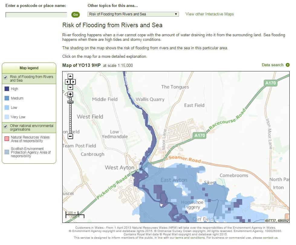
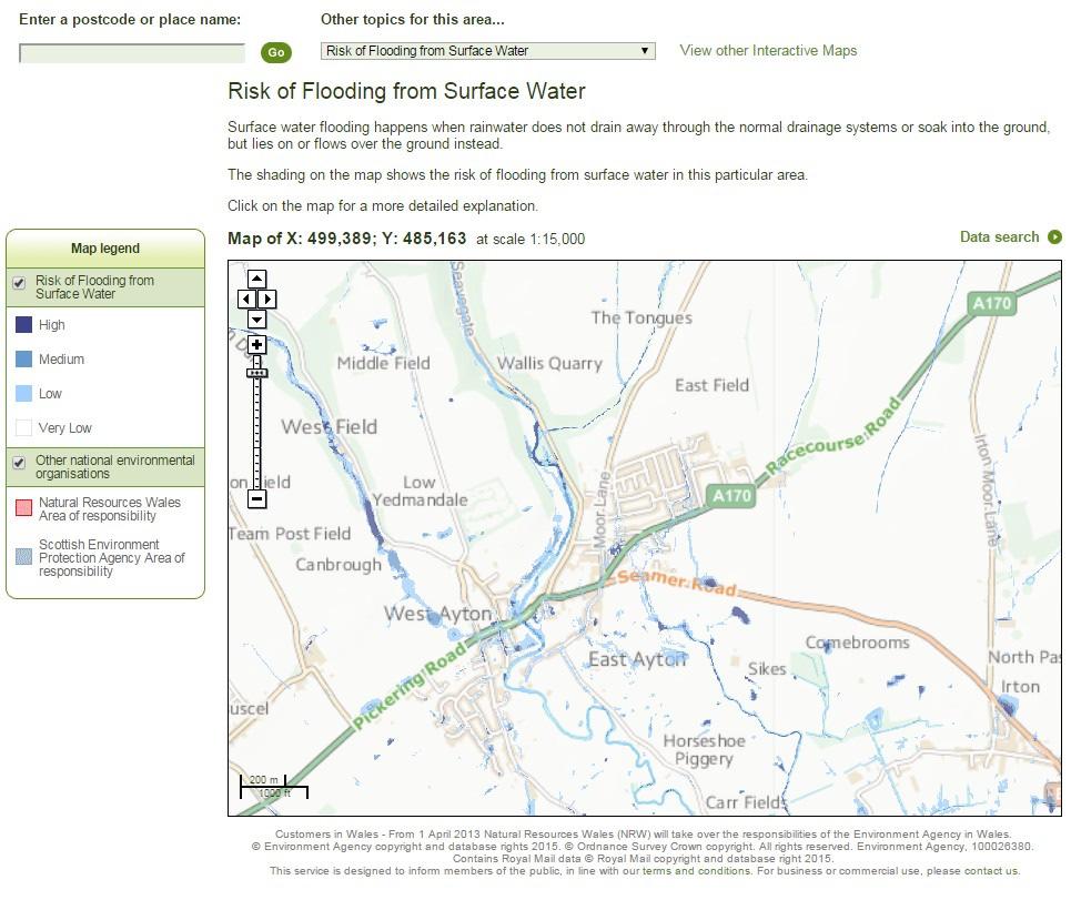
8 8
9 8. SUSTAINABILITY The dwellings will comply with current building regulations and be efficient in terms of thermal insulation and energy consumption which assists in minimising the carbon footprint. Construction materials and components wherever possible will be selected with regard to life cycle costing impact, the amount of energy embodied within and with a view to recyclability. Reclaimed and recycled materials will also be used, sourced locally wherever possible to benefit the local economy and community. The scheme design aims to create a living environment, which will enhance the health and wellbeing of both its residents and the surrounding community. The houses will benefit from thermally efficient heating systems and it is intended to supplement the domestic hot water with solar panels included within the design. NB these have not been indicated on the accompanying drawings as they will be sized and designed by specialist installer. They will be located on the south facing roof pitches wherever possible. The use of these zero carbon technologies is intended to reduce the demand on fossil fuels. The village is served by a regular bus service between Scarborough and Pickering. The national Rail network is available at Scarborough or York, and the A64 trunk road connects to the motorway network. The facilities in East Ayton include a Parish Church, a Public House, Restaurant, Petrol Station, a Hotel and Country House and a Primary School. 9. DESIGNING OUT CRIME The proposed dwellings are arranged to provide close supervision of the shared access road, the parking spaces, the public areas and the private gardens. The provision of distinct borders with well-defined public and private spaces discourage antisocial behaviour and reduces the risk of crime. The development is intended to encourage a community feel and promote a crime-watch conscious neighbourhood. The scheme at detailed stage would be considered in conjunction with the police architectural liaison officer. 10. CONCLUSIONS The site currently consists of open arable farmland set on the eastern edge of the village, with few features other than the existing hedges to the boundary along the western perimeter. The existing adjoining properties consist of a housing estate to the north beyond Racecourse Road, which is a mixture of dwelling types but predominantly bungalows, and a similar site to the west with mainly corporation style two storey dwellings. 9
10 The proposed new dwellings are intended to sit sympathetically and unobtrusively in this part of the village and provide much sought after residential accommodation in this rural village location. The additional new residents, by increasing the village population, will help to improve the viability of the village community and with use of the local facilities, will promote the sustainability of the village. We believe this design statement has set out a well-considered scheme and how it has evolved to provide a good mix of types to meet the local housing need. The material planning considerations relevant to the determination of this application have been set out in relation to the national, regional and local plan policy as described in the Planning Supporting Statement by Yew Tree Associates. We hope to have demonstrated that the broad principle of development on this site complies with these policies on many levels. The applicant hopes that Scarborough Borough Council is able to support this planning application for the development of a range of high quality dwellings to be constructed on the site. 10
DESIGN & ACCESS STATEMENT
 DESIGN & ACCESS STATEMENT January 2016 Contents Introduction section 1 Section 1 - Introduction Section 2 - Assessment Section 3 - Involvement Section 4 - Evaluation Section 5 - Design Section 6 - Layout
CAERNARFON DEPENDENCY CATCHMENT AREA
 CAERNARFON DEPENDENCY CATCHMENT AREA GWYNEDD UNITARY DEVELOPMENT PLAN - HOUSING Map not to scale Dependency Catchment Area Location 2 Caernarfon Topic Housing To the rear of Bro Eglwys, Bethel. Grid Ref.
Site north of Hattersley Road West (east of Fields Farm Road), Hattersley
, Hattersley") Application Number 17/00982/REM Proposal Site Applicant Recommendation Reason for report Application for the approval of reserved matters (means of access, landscaping, layout, scale and appearance) relating
Application Number 17/00982/REM Proposal Site Applicant Recommendation Reason for report Application for the approval of reserved matters (means of access, landscaping, layout, scale and appearance) relating
Harrow Lane, St Leonards-on-Sea, East Sussex, TN37 7JZ ERECTION OF 113 DWELLINGS TOGETHER WITH ESTATE ROADS (DETAILED SUBMISSION)
") AGENDA ITEM NO: Report to: PLANNING BOARD Date: 10 September, 2003 Report from: Borough Planning Officer Application Address: Proposal: Application No: Recommendation: Ward: File No: Applicant: Interest:
AGENDA ITEM NO: Report to: PLANNING BOARD Date: 10 September, 2003 Report from: Borough Planning Officer Application Address: Proposal: Application No: Recommendation: Ward: File No: Applicant: Interest:
CALA HO ME S WELCOME
 WELCOME Welcome to this public consultation event for our proposed residential development of 56 high quality homes on land to the north east of Station Road in Earls Colne. Thank you for taking the time
SOUTH CAMBRIDGESHIRE DISTRICT COUNCIL. Executive Director (Operational Services) Corporate Manager (Planning and New Communities)
 Corporate Manager (Planning and New Communities)") SOUTH CAMBRIDGESHIRE DISTRICT COUNCIL REPORT TO: Planning Committee 12 January 2011 AUTHOR/S: Executive Director (Operational Services) Corporate Manager (Planning and New Communities) Notes: S/1848/10
SOUTH CAMBRIDGESHIRE DISTRICT COUNCIL REPORT TO: Planning Committee 12 January 2011 AUTHOR/S: Executive Director (Operational Services) Corporate Manager (Planning and New Communities) Notes: S/1848/10
3 Abbey View Mill Hill London NW7 4PB
 Location 3 Abbey View Mill Hill London NW7 4PB Reference: 15/03203/HSE Received: 26th May 2015 Accepted: 16th June 2015 Ward: Mill Hill Expiry 11th August 2015 Applicant: Proposal: Mr Richard Benson Alterations
South of Hillside Road West, Rothbury. Design and Access Statement with Design Code. Outline Planning Application May 2016
 Outline Planning Application May 2016 Design and Access Statement with Design Code Jane Darbyshire and David Kendall Ltd This Design and Access Statement has been produced by Jane Darbyshire and David
Public Consultation. Land at Monks Farm, North Grove. Welcome
 Welcome Welcome to our public exhibition for development on Land at Monks Farm, orth Grove. Gallagher Estates and Gleeson Strategic Land are preparing an outline planning application for new homes, open
Schedule of Planning Applications Committee Date: 23 May Reference: 06/17/0726/F Parish: Hemsby Officer: Mr J Beck Expiry Date:
 Schedule of Planning Applications Committee Date: 23 May 2018 Reference: 06/17/0726/F Parish: Hemsby Officer: Mr J Beck Expiry Date: 22-05-2018 Applicant: Proposal: Site: Mr Gillett Change of use to the
PROPOSED RESIDENTIAL DEVELOPMENT LAND AT TRETHURFFE LADOCK, TRURO Design & Access Statement
 PROPOSED RESIDENTIAL DEVELOPMENT LAND AT TRETHURFFE LADOCK, TRURO Design & Access Statement Heron Way, Newham, Truro, Cornwall, TR1 2XN Tel: 08453 707 111 Fax: 08453 707 113 www.csa-architects.co.uk E:
Statement of Community Involvement LAND OFF SOUTHDOWN ROAD HORNDEAN, HAMPSHIRE
 LAND OFF SOUTHDOWN ROAD HORNDEAN, HAMPSHIRE CONTENTS Page 1. Introduction 3 2. Pre-application Discussions 4 3. The Consultation Process 5 4. Consultation Feedback 7 5. Responses to Consultation Feedback
Housing Development at Balloonagh Tralee Co Kerry
 Design Statement Housing Development at Balloonagh Tralee Co Kerry Area of site 10,400m2 24 houses-12no 3 bed, 12no 2 bed and 4 single bed apartments total residential area of 2411m2 Open space provided
Derry City and Strabane District Council Planning Committee Report
 Derry City and Strabane District Council Planning Committee Report COMMITTEE DATE: 23 rd March 2016 APPLICATION No: APPLICATION TYPE: PROPOSAL: LOCATION: APPLICANT: LA11/2015/0395/F Residential Development
Welcome. Land adjacent Sandy Lane WALTHAM CHASE THE PROPOSED SITE
 Land adjacent Sandy Lane WALTHAM CHASE Existing Linden Homes developments Welcome Welcome to Linden Homes Southern s ( Linden ) public exhibition about its proposals for a range of high-quality homes for
Application Recommended for Approval Hapton with Park Ward
 Application Recommended for Approval Hapton with Park Ward APP/2017/0036 Outline Planning Application Outline application for the construction of a new 3 bedroom dwelling (with all matters reserved for
DEVELOPMENT MANAGEMENT REPORT
 ITEM A08-1 DEVELOPMENT MANAGEMENT REPORT TO: BY: DATE: DEVELOPMENT: SITE: WARD: APPLICATION: APPLICANT: Development Management Committee Development Manager Proposed live/work unit in connection with existing
Land Adj. 63 Sunny Bank Road, Sutton Coldfield, Birmingham, B73 5RJ
 Committee Date: 11/07/2013 Application Number: 2013/03520/PA Accepted: 20/05/2013 Application Type: Full Planning Target Date: 15/07/2013 Ward: Sutton Vesey Land Adj. 63 Sunny Bank Road, Sutton Coldfield,
INTRODUCTION. Land south of Bishopswood Lane, Tadley
 0 INTRODUCTION THE SITE Introduction Gladman Developments Ltd. has successfully invested in communities throughout the UK over the past 0 years, developing high quality and sustainable residential, commercial
Section Three, Appendix 16C Medium Density Housing, Design Assessment Criteria (Residential 8A zone)
") APPENDIX 16C MEDIUM DENSITY HOUSING, DESIGN ASSESSMENT CRITERIA (RESIDENTIAL 8A ZONE) PURPOSE OF APPENDIX 16C (RESIDENTIAL 8A ZONE) In the Residential 8A Zone the following are defined as restricted discretionary
APPENDIX 16C MEDIUM DENSITY HOUSING, DESIGN ASSESSMENT CRITERIA (RESIDENTIAL 8A ZONE) PURPOSE OF APPENDIX 16C (RESIDENTIAL 8A ZONE) In the Residential 8A Zone the following are defined as restricted discretionary
DESIGN & ACCESS STATEMENT
 DESIGN & ACCESS STATEMENT Land to the South East of the A495, Bronington Erection of 31 Dwellings (27 dwellings and 4 bungalows including 4 Affordable Dwellings), Realignment and Improvements to A495 (including
Reference: 16/1447/FUL Received: 7th March 2016 Accepted: 7th March 2016 Ward: East Finchley Expiry 2nd May 2016
 Location 374B Long Lane London N2 8JX Reference: 16/1447/FUL Received: 7th March 2016 Accepted: 7th March 2016 Ward: East Finchley Expiry 2nd May 2016 Applicant: Ms Katrin Hirsig Proposal: Single storey
PLANNING COMMITTEE. 14 October 2014
 AGENDA ITEM NO 8 PLANNING COMMITTEE 14 October 2014 APPLICATION NUMBER : CA//14/01744/FUL PROPOSAL : Extension and conversion of roof space of an existing detached bungalow together with enhanced parking
Section Three, Appendix 17C Multiple Unit Housing Design Assessment Criteria
 APPENDIX 17C MULTIPLE UNIT HOUSING DESIGN ASSESSMENT CRITERIA Purpose of Appendix 17C In the Residential 9 Zone the construction and use of multiple household units located within the Multiple Household
DESIGN & ACCESS STATEMENT. REVISION A Residential Development, Neon Social Club, Nairn Street, Jarrow.
 DESIGN & ACCESS STATEMENT. REVISION A Residential Development, Neon Social Club, Nairn Street, Jarrow. The following Design & Access Statement is in support of a Full Planning Application for a residential
8.0 Design and Form of Development 43/
 42/ 8.0 Design and Form of Development 43/ Rothwells Farm, Golborne/ Development Statement Figure 7. Site Constraints Key 44/ Site Boundary 360 Bus Route/Stops Existing Trees Underground Water Pipe Sensitive
BLACKHEATH SQUASH CLUB Blackheath Sports Club, Rectory Field, Charlton Road, London, SE7 7EY. Planning, Design and Access Statement
 Planning, Design and Access Statement Revised: 28 th Jan 2016 Peter Pendleton & Associates Ltd Introduction Planning permission will be sought for a refurbishment of existing courts and extension to provide
Site off Hattersley Road West (bound by Hattersley Road West to the north west and Sandy Bank Avenue to the south and west), Hattersley
, Hattersley") Application Number 17/00984/REM Proposal Site Applicant Recommendation Reason for report Application for the approval of reserved matters (means of access, landscaping, layout, scale and appearance) relating
Application Number 17/00984/REM Proposal Site Applicant Recommendation Reason for report Application for the approval of reserved matters (means of access, landscaping, layout, scale and appearance) relating
Welcome to our public exhibition
 About our development Welcome to our public exhibition This exhibition gives you the chance to view and comment on our proposals for a new residential development of 165 high-quality homes, along with
Mr & Mrs Connolly per Pump House Designs Pump House Yard The Green SEDLESCOMBE, East Sussex. TN33 0QA
 AGENDA ITEM NO: 5 (c) Report to: PLANNING COMMITTEE Date: 03 June 2015 Report from: Head of Housing and Planning Services Application Address: Proposal: Application No: Recommendation: Ward: File No: Applicant:
Environmental and Landscape Mapping
 Environmental and Landscape Mapping In support of the Calveley Neighbourhood Plan November 2016 Project Name and Number: Calveley Neighbourhood Plan 16-025 Document Name and Revision: Environmental and
5 Gratton Terrace London NW2 6QE. Reference: 17/5094/HSE Received: 4th August 2017 Accepted: 7th August 2017 Ward: Childs Hill Expiry 2nd October 2017
 Location 5 Gratton Terrace London NW2 6QE Reference: 17/5094/HSE Received: 4th August 2017 Accepted: 7th August 2017 Ward: Childs Hill Expiry 2nd October 2017 Applicant: WSD (Gratton) Ltd Proposal: The
PLANNING COMMITTEE 15 September 2015
 AGENDA ITEM NO 12 PLANNING COMMITTEE 15 September 2015 APPLICATION NUMBER : CA//15/01402/FUL PROPOSAL : Single-storey conservatory to rear. LOCATION OF SITE : 5 Mill Lane, Herne, CT6 7ED APPLICATION TYPE
Welcome to our Public Consultation
 About our development This exhibition gives you the chance to view and comment on our emerging plans for a proposed residential development located on land to the West of Alwyn Road, Rugby. Welcome to
Duplex Design Guidelines
 Duplex Design Guidelines Adopted by Council May 29, 2006 Prepared By: Table of Contents 1.0 Application and Intent 1 2.0 Areas of Application 2 3.0 Design Principles 3 4.0 Design Guidelines 4 4.1 Site
INTRODUCTION CURRENT APPLICATION
 05/01805/FUL & 05/01807/LBC ERECTION OF A SINGLE DWELLING HOUSE WITH ANCILLARY ACCOMMODATION AT Flamingo Zoological Gardens, Olney Road, Weston Underwood FOR Mr A J Crowther (as amended by letter dated
Welcome to our public exhibition
 About Our Scheme Welcome to our public exhibition This exhibition gives you the chance to view and comment upon our emerging proposals for a new residential development of 68 new homes on the site of the
Design and Access Statement. Redevelopment of Marcris House, Coopersale Lane, Theydon Boise to provide 11 new apartments.
 Design and Access Statement for Redevelopment of Marcris House, Coopersale Lane, Theydon Boise to provide 11 new apartments Prepared by ISL Architecture For Chigwell Homes Ltd dated October 2015 1 Introduction
Ground Floor Flat 15 Redbourne Avenue London N3 2BP
 Location Ground Floor Flat 15 Redbourne Avenue London N3 2BP Reference: 17/4160/FUL Received: 28th June 2017 Accepted: 29th June 2017 Ward: West Finchley Expiry 24th August 2017 Applicant: Proposal: Mr
WELCOME. Land North of STEVENAGE. We would like to thank you for attending our public exhibition today.
 WELCOME We would like to thank you for attending our public exhibition today. The purpose of this event is to share our proposals and hear your thoughts on our ideas. Members of the project team are on
6. Design and Architectural Guidance
 6. Design and Architectural Guidance The following Design Guidelines are proposed to apply to all areas of Haslemere. They are intended to enhance and maintain the character and scale of the area. Principles
This image is an illustration of a similar scale scheme on a different site by Stitch
 Stitch design approach Site 74 - MALTON HOUS This image is an illustration of a similar scale scheme on a different site by Stitch Stitch has been appointed as architect for six sites across the northern
Derry City and Strabane District Council Planning Committee Report
 Derry City and Strabane District Council Planning Committee Report COMMITTEE DATE: 29 th November 2017 APPLICATION No: APPLICATION TYPE: PROPOSAL: LOCATION: APPLICANT: AGENT: LA11/2016/0854/O Outline Shared
ENVIRONMENTAL AND LANDSCAPE MAPPING
 APPENDIX IV : Environmental and Landscape Mapping ENVIRONMENTAL AND LANDSCAPE MAPPING Calveley Neighbourhood Plan November 2016 ENVIRONMENTAL AND LANDSCAPE MAPPING Calveley Neighbourhood Plan Calveley
Ward: Southbourne. Outline application with all matters reserved. Erection of 5 no. dwellings and associated works.
 Parish: Southbourne Ward: Southbourne SB/16/00205/OUT Proposal Site Outline application with all matters reserved. Erection of 5 no. dwellings and associated works. Dunkirk South Lane Southbourne Emsworth
RESIDENTIAL ACTIVITY PERFORMANCE STANDARDS
 Preferred Options Consultation Q&A Sheet RESIDENTIAL ACTIVITY PERFORMANCE STANDARDS What are the key goals for managing the design of residential buildings in the Second Generation Plan (2GP)? The key
6B Bertram Road London NW4 3PN
 Location 6B Bertram Road London NW4 3PN Reference: 16/6621/RCU Received: 14th October 2016 Accepted: 19th October 2016 Ward: West Hendon Expiry 14th December 2016 Applicant: Proposal: Ms Kavita Singh Erection
Story Homes. Land at Thirsk Road, Kirklevington. An Introduction to Story Homes. Our Foundations. Commitment to Consultation.
 Story Homes An Introduction to Story Homes Founded by Fred Story in 1987, Story Homes has a long and successful reputation of building high quality and high specification homes. The family owned business
1 The development hereby permitted shall be carried out in accordance with the following approved plans:
 Location 59 Greenway Close London N20 8ES Reference: 16/00011/HSE Received: 30th December 2015 Accepted: 7th January 2016 Ward: Totteridge Expiry 3rd March 2016 Applicant: Mr Ankit Shah Proposal: Part
Chapter 2: OUTLINE PLANNING APPLICATION PROPOSALS. A New Garden Neighbourhood Matford Barton 17
 Chapter 2: OUTLINE PLANNING APPLICATION PROPOSALS A New Garden Neighbourhood Matford Barton 17 2.1. SUMMARY AND STATUS OF THE PROPOSALS 2.1.1. The parameter plans and associated wording in this chapter
25 Clarry Drive, Sutton Coldfield, Birmingham, B74 2QT
 Committee Date: 04/09/2014 Application Number: 2014/02480/PA Accepted: 09/04/2014 Application Type: Full Planning Target Date: 04/06/2014 Ward: Sutton Four Oaks 25 Clarry Drive, Sutton Coldfield, Birmingham,
Neighbourhood Planning Site Assessment Pro-forma and Guide Version 2
 Neighbourhood Planning Site Assessment Pro-forma and Guide Version 2 September 2014 Site HNP 006 Land East of Stanbridge Road and North of Lower Road 1. Background information Site location and use Site
PLANNING, DESIGN AND ACCESS STATEMENT
 PLANNING, DESIGN AND ACCESS STATEMENT PROPOSED FREE RANGE CHICKEN SHED AT LAND NORTH OF GLANMYDDYFI, PENTREFELIN, LLANDEILO On behalf of Our Ref: 0161.a Date: February 2018 Prepared by: JDE 1.0 INTRODUCTION...3
DESIGN & ACCESS STATEMENT
 DESIGN & ACCESS STATEMENT Demolition of Detached Dwellinghouse and Construction of 11 Dwellinghouses with Access Road & Associated Infrastructure, Ystradgynlais, Powys On Behalf of Watree Homes Limited
Kibworth Harcourt. Introduction. Introduction
 Introduction Introduction Welcome to this public exhibition on the proposals for the delivery of new homes on land at The Kibworths. The purpose of today s exhibition is to give you the opportunity to
1.0 INTRODUCTION. Brantham Industrial Area Regeneration - Factory Lane - Brantham
 1.0 INTRODUCTION Welcome to this exhibition of our proposals for the regeneration of the Brantham Industrial Area located off Factory Lane in Brantham. This presentation will give you an opportunity to
DELEGATED DECISION on 1st September 2015
 Application N o : 14/04810/OUT LONDON BOROUGH OF BROMLEY TOWN PLANNING RENEWAL AND RECREATION DEPARTMENT DELEGATED DECISION on 1st September 2015 14/04810/OUT Claire Harris 4 Oaklands Road Bromley BR1
Reference: 16/1234/HSE Received: 25th February 2016 Accepted: 2nd March 2016 Ward: High Barnet Expiry 27th April 2016
 Location 7 Sunset View Barnet EN5 4LB Reference: 16/1234/HSE Received: 25th February 2016 Accepted: 2nd March 2016 Ward: High Barnet Expiry 27th April 2016 Applicant: Proposal: Mr & Mrs Peter & Anny Woodhams
ALLERTHORPE NEIGHBOURHOOD PLAN
 Allerthorpe s Neighbourhood Plan sets out a vision for the Parish for the next 15 years (2018 2033) that builds on and reflects the opinions and views of parish residents. VISION In 2033 Allerthorpe will
3 Tretawn Gardens London NW7 4NP
 Location 3 Tretawn Gardens London NW7 4NP Reference: 16/7886/HSE Received: 12th December 2016 Accepted: 19th December 2016 Ward: Mill Hill Expiry 13th February 2017 Applicant: Proposal: Mr Murray Two storey
Site ref: AS06 Site Name or Address: Murreys Court, Agates Lane
 Site ref: AS06 Site Name or Address: Murreys Court, Agates Lane Proposed Land Use: Total Site Area (Ha): Housing 1.85 Ha Description: It is understood that the owner has no plans to dispose of the site
BUILDING PLOT ADJACENT TO 21 NOTTINGHAM ROAD, BOTTESFORD LEICESTERSHIRE NG13 0AP GUIDE PRICE 120, Market Place Bingham Nottingham NG13 8AR
 11 Market Place Bingham Nottingham NG13 8AR Tel: (01949) 87 86 85 bingham@hammondpropertyservices.com BUILDING PLOT ADJACENT TO 21 NOTTINGHAM ROAD, BOTTESFORD LEICESTERSHIRE NG13 0AP Selected as the best
September A new neighbourhood at Kemsing Station. Concept Masterplan
 September 2018 A new neighbourhood at Kemsing Station Concept Masterplan 1 Kemsing Station Neighbourhood - Key Benefi ts Transport Hub Extra parking, station improvements and links across the district
DESIGN AND ACCESS STATEMENT Reserved Matters Application
 DESIGN AND ACCESS STATEMENT Reserved Matters Application Submitted to: Newcastle Under Lyme Borough Council Prepared by: Nicol Thomas Architects On behalf of: Kier Living Proposed Residential Development
EXTRACT FROM THE CUDDINGTON NEIGHBOURHOOD PLAN The Policies
 EXTRACT FROM THE CUDDINGTON NEIGHBOURHOOD PLAN The Policies Environment and Landscape Policy 1 - Landscape Setting Development should respect and wherever possible enhance the landscape setting of Cuddington
Carterton Construction Ltd is bringing forward plans for up to 85 new family homes and extra care facilities on land east of Burford.
 Welcome Carterton Construction Ltd is bringing forward plans for up to 85 new family homes and extra care facilities on land east of. We are at the early stages of designing our proposals and have a number
SOUTH EAST LINCOLNSHIRE LOCAL PLAN: HOUSING PAPER DONINGTON (JUNE 2016)
") SOUTH EAST LINCOLNSHIRE LOCAL PLAN: HOUSING PAPER DONINGTON (JUNE 2016) 1 DONINGTON S PLACE IN THE SPATIAL STRATEGY 1.1 Policy 2 of the South East Lincolnshire Local Plan 2011-2036 Draft for Public Consultation
SOUTH EAST LINCOLNSHIRE LOCAL PLAN: HOUSING PAPER DONINGTON (JUNE 2016) 1 DONINGTON S PLACE IN THE SPATIAL STRATEGY 1.1 Policy 2 of the South East Lincolnshire Local Plan 2011-2036 Draft for Public Consultation
ABOUT CALA HOMES CALA HOMES
 WELCOME Welcome to this public consultation event for our proposed development on land to the east of Salisbury Road, in Hungerford. Thank you for taking the time to come along today. Homes and Wates Developments
Introduction. Welcome to this consultation regarding the draft redevelopment proposals for the former CeramTec factory on Sidmouth Road, Colyton.
 Introduction Welcome to this consultation regarding the draft redevelopment proposals for the former CeramTec factory on Sidmouth Road, Colyton. We are currently considering options for the mixed-use redevelopment
SOUTH CAMBRIDGESHIRE DISTRICT COUNCIL. Director of Development Services
 SOUTH CAMBRIDGESHIRE DISTRICT COUNCIL REPORT TO: Development and Conservation Control Committee 5 th April 2006 AUTHOR/S: Director of Development Services S/2290/05/F Haslingfield House (Revised Design)
Welcome to our public exhibition
 About our scheme Welcome to our public exhibition Taylor Wimpey East Anglia intends to submit a detailed planning application for a new residential development of 39 high-quality homes at the B&M Concrete
edge of gas line corridor setback edge of gas line corridor aligned with Schlumberger building 37.0 m AOD 33.0 m AOD max
 7. Heights and Street Frontage: In accordance with the approved heights parameters, heights to along Western Access Road must respond to the existing low density character in this location. Heights are
4 Residential and Urban Living Zones
 4 Residential and Urban Living Zones Refer to Chapters 11 to 20 for additional rules that may apply to these zones. 4.1 OBJECTIVES AND POLICIES Objective Res1 Policy 1 Policy 2 Policy 3 Policy 4 Policy
STATEMENT OF OBJECTION TO THE PROPOSED DEVELOPMENT OF LAND AT CHURCH CLIFF DRIVE FILEY
 STATEMENT OF OBJECTION TO THE PROPOSED DEVELOPMENT OF LAND AT CHURCH CLIFF DRIVE FILEY You will be aware that Scarborough borough council have adopted a new local plan that includes land at Church Cliff
VIEW PLANS AT: mmary&keyval=ny3yzlhy0b100
 HARROGATE BOROUGH COUNCIL 09/6.49.165.A.OUT /15/05195/OUT/0 09/6.49.165.A.OUT /15/05195/OUT/1 DATE: 12 May 2016 PLAN: 09 CASE NUMBER: 15/05195/OUT GRID REF: EAST 416110 NORTH 465707 APPLICATION NO. 6.49.165.A.OUT
Land off Arbour Close and Cotswold Edge Mickleton, Gloucestershire. Design and Access Statement Mickleton, Gloucestershire
 Land off Arbour Close and Cotswold Edge Contents INTRODUCTION Vision SITE DESCRIPTION The site Technical Assessment ASSESSMENT & EVALUATION Constraints and opportunities SITE CONTEXT Pattern of Development
WELCOME GYPSY LANE. Wider Site Location plan. Proposals for the development of LAND OFF FOXLYDIATE LANE WEBHEATH. Proposals for the development of
 WELCOME The developers are preparing an outline planning application for a residential led development and need the community s views in order to develop the proposals further WHAT IS PROPOSED? A high
Land at Rampton Road. Cottenham
 Land at Rampton Road Cottenham Introduction TEP is preparing an outline planning application for 54 dwellings on 6.9 hectares of land adjacent to Rampton Road, Cottenham on behalf of the owners Cambridgeshire
an Inspector appointed by the Secretary of State for Communities and Local Government Decision date: 13 February 2018
 Appeal Decision Site visit made on 23 January 2018 by Stephen Hawkins MA MRTPI an Inspector appointed by the Secretary of State for Communities and Local Government Decision date: 13 February 2018 Appeal
LAND TO THE NORTH OF ASTON ROAD HADDENHAM
 LAND TO THE NORTH OF ASTON ROAD HADDENHAM Design & Access Statement Incorporating Design Code IN SUPPORT OF RESERVED MATTERS APPLICATION PHASE 1 & 2 May 2017 FOREWORD ABOUT DANDARA Emerging over the last
LONGDEN VILLAGE DEVELOPMENT STATEMENT
 LONGDEN VILLAGE DEVELOPMENT STATEMENT 2017-2027 1 Longden Development Statement 2017-2027 15/01/18 1. Background 1.1 Longden Village Longden village is a very rural and traditional community first mentioned
CHANGE OF USE FROM PADDOCK TO RESIDENTIAL GARDEN LAND AT Yew Tree Cottage, Timpson Lane, Clifton Reynes FOR Iain Morrison
 08/01064/FUL CHANGE OF USE FROM PADDOCK TO RESIDENTIAL GARDEN LAND AT Yew Tree Cottage, Timpson Lane, Clifton Reynes FOR Iain Morrison INTRODUCTION Yew Tree Cottage is a detached dwelling at the northern
GREENFORD HALL & ADJOINING LAND
 GREENFORD HALL & ADJOINING LAND CONTENTS 1. Introduction 1. Introduction 2. Urban Context 2.1 The Site and Surroundings 2.2 Urban Context Map 2.3 Access and Movement 3. Planning Context 3.1 Planning History
Briefing Document of CNP. June 2017
 Cholsey Parish Council Cholsey Neighbourhood Plan Briefing Document of CNP June 2017 Cholsey Neighbourhood Plan Page! 1 of! 8 Cholsey Plan Briefing v1.4 Page Left Intentionally Blank Cholsey Neighbourhood
PLANNING COMMITTEE REPORT
 PLANNING COMMITTEE REPORT TO: BY: Planning Committee South Head of Development DATE: 19 December 2017 DEVELOPMENT: SITE: WARD: APPLICATION: APPLICANT: Conversion of existing water storage reservoir to
18 Birkbeck Road London NW7 4AA. Reference: 15/02994/HSE Received: 14th May 2015 Accepted: 26th May 2015 Ward: Mill Hill Expiry 21st July 2015
 Location 18 Birkbeck Road London NW7 4AA Reference: 15/02994/HSE Received: 14th May 2015 Accepted: 26th May 2015 Ward: Mill Hill Expiry 21st July 2015 Applicant: Proposal: Mrs Tania Kallis Single storey
Case Officer: Sarah Kay File No: CHE/14/00515/REM Tel. No: (01246) Plot No: 2/6132 Ctte Date: 15 th September 2014 ITEM 1
 Plot No: 2/6132 Ctte Date: 15 th September 2014 ITEM 1") Case Officer: Sarah Kay File No: CHE/14/00515/REM Tel. No: (01246) 345786 Plot No: 2/6132 Ctte Date: 15 th September 2014 ITEM 1 APPROVAL OF RESERVED MATTERS FROM APPLICATION CHE/12/00234/OUT (1) LAYOUT,
Case Officer: Sarah Kay File No: CHE/14/00515/REM Tel. No: (01246) 345786 Plot No: 2/6132 Ctte Date: 15 th September 2014 ITEM 1 APPROVAL OF RESERVED MATTERS FROM APPLICATION CHE/12/00234/OUT (1) LAYOUT,
Land at the Junction of White Farm Road & Harrison Road, Four Oaks, Sutton Coldfield, B74 4LQ
 Committee Date: 18/04/2013 Application Number: 2013/00924/PA Accepted: 13/02/2013 Application Type: Full Planning Target Date: 15/05/2013 Ward: Sutton Four Oaks Land at the Junction of White Farm Road
Derry City and Strabane District Council Planning Committee Report. Amended layout from approval A/2004/0462/F with reduction from 166 units
 Derry City and Strabane District Council Planning Committee Report COMMITTEE DATE: 1 st February 2017 APPLICATION No: APPLICATION TYPE: PROPOSAL: LOCATION: APPLICANT: AGENT: Full Planning application Amended
OKEFORD FITZPAINE NEIGHBOURHOOD PLAN
 OKEFORD FITZPAINE NEIGHBOURHOOD PLAN Dear Parishioner, The Neighbourhood Plan Project Team have prepared this leaflet to summarise the full Neighbourhood Plan document. It provides a summary of the Vision,
MATURE SUBURBS RESIDENTIAL DEVELOPMENT GUIDELINES
 MATURE SUBURBS RESIDENTIAL DEVELOPMENT GUIDELINES DRAFT FEBRUARY 2005 BIRMINGHAM CITY COUNCIL 1 Introduction Mature Suburbs Residential Development Guidelines - Interim Supplementary Planning Advice -
Cape Cabarita (Formerly known as the Wellcome Site) Development Control Plan. Date of Adoption: 4 September 2007 Effective Date: 7 March 2008
 Development Control Plan. Date of Adoption: 4 September 2007 Effective Date: 7 March 2008") Cape Cabarita (Formerly known as the Wellcome Site) Development Control Plan Date of Adoption: 4 September 2007 Effective Date: 7 March 2008 Development Control Plan Index 1 INTRODUCTION...3 1.1 LAND TO
Cape Cabarita (Formerly known as the Wellcome Site) Development Control Plan Date of Adoption: 4 September 2007 Effective Date: 7 March 2008 Development Control Plan Index 1 INTRODUCTION...3 1.1 LAND TO
Subdivision Design Criteria. Penihana North GUIDELINES TO THE RULES
 Created September 2013 Penihana North Subdivision Design Criteria GUIDELINES TO THE RULES This part of the Plan sets out the design criteria for subdivision in Penihana North. The criteria will be considered
Memorial Business Park Site. Proposed Future Development. Design guidelines. August
 Memorial Business Park Site Proposed Future Development Design guidelines August 2014 www.designenvironment.co.nz 0064 3 358 3040 Contents 1.0 Background 1.1 Introduction 3 1.2 Objectives 4 2.0 Context
St Michaels C of E Junior & Infant School, Nantmel Grove, Bartley Green, Birmingham, B32 3JS
 Committee Date: 06/03/2014 Application Number: 2013/08595/PA Accepted: 19/11/2013 Application Type: Full Planning Target Date: 14/01/2014 Ward: Bartley Green St Michaels C of E Junior & Infant School,
Land at BROOK STREET PROPERTIES TENCREEK FARM, LISKEARD. Environmental Statement: Non-Technical Summary
 BROOK STREET PROPERTIES TENCREEK FARM, LISKEARD Land at Environmental Statement: Non-Technical Summary Introduction Brook Street Properties is applying to Cornwall Council for outline planning permission
Appendix 1
 Appendix 1 Appendix 2 PLANNING COMMITTEE 31 March 2015 APPLICATION NUMBER : CA//14/02087/FUL PROPOSAL : Redevelopment of site to provide two detached dwellings with detached garages, shared access
Land at Weather Oaks, Harborne, Birmingham, B17 9DD. Erection of 11 new dwellings and associated infrastructure, parking and landscaping
 Committee Date: 23/07/2015 Application Number: 2015/03396/PA Accepted: 29/04/2015 Application Type: Full Planning Target Date: 29/07/2015 Ward: Harborne Land at Weather Oaks, Harborne, Birmingham, B17
Introduction & Proposals
 Introduction & Proposals This exhibition is being arranged to seek the views of the local community for the initial proposals of a residential led development of land at Picket Piece, Andover. This could
Application and Proposals. Part 211
 Application and Proposals Part 211 Site Location and Context The application site comprises two distinct land parcels totalling some 135 hectares. The site is bisected eastwest by Churchlands Development.