WASHINGTON COUNTY OREGON
|
|
|
- Kory Shaw
- 5 years ago
- Views:
Transcription

1 WASHINGTON COUNTY OREGON LONG RANGE PLANNING DIVISION North Bethany Subarea Stream Corridors: Existing Regulations In Oregon, there is a distinct difference between the land use rules that apply in rural areas versus those that apply in urban areas. Applying existing urban regulations to the formerly rural North Bethany Subarea (North Bethany) is a necessary preliminary step in the urbanization process. The focus of this fact sheet is to identify the relevant regulatory programs that apply to natural water features. In some cases more than one program will apply to a specific feature; for instance, some floodplain areas may also be jurisdictional wetlands. This paper describes each program individually, and explains generally how those rules are applied. Only existing regulatory programs are being applied to North Bethany. While no new rules are proposed, new information is being incorporated for wetland areas. The wetland data update is required under state law, as further explained below. The county has multiple existing regulatory programs that apply to various types of water features, including Drainage Hazard Areas (DHA), Floodplain areas, Jurisdictional Wetlands, Water Quality Sensitive Areas and Vegetated Corridors (regulated by Clean Water Services), and Fish & Wildlife Habitat (county Goal 5 program). Each program is designed to mitigate impacts of development relative to a particular natural process, feature or function. Related development standards are found in the county s Community Development Code (CDC) and in Clean Water Services Design and Construction Standards for Sanitary Sewer and Surface Water Management (D&C Standards). In some cases more than one regulatory program applies to a subject area or feature, and often those regulatory boundaries are not the same. For instance, natural stormwater drainage ways are typically existing stream channels, which also qualify as jurisdictional wetlands. In these situations, the regulatory measures overlap. Because of this overlap, regulations applied in isolation do not paint a complete scenario. For example, a wetland boundary is not sufficient to determine the extent of a wildlife habitat area, nor the boundaries of a DHA or 100-year floodplain. Likewise, necessary alterations within a given resource area such as culvert installation or replacement for a road crossing may be subject to more than one set of regulations, some of which may have ramifications for other applicable regulatory programs. The purpose of a particular program can be either to protect natural areas from development impacts, as is the case for certain fish and wildlife habitat areas (Goal 5), preserve water quality (Goal 6), and/or to protect development improvements from the negative effects of natural hazards, as is the case with floodplain restrictions (Goal 7, FEMA). This fact sheet explains how these existing regulations are applied and assesses the general implications of each for affected areas in North Bethany. Department of Land Use & Transportation Long Range Planning Division 155 N First Avenue, Suite , Hillsboro, OR Phone: (503) Fax: (503)
2 Page 2 of 6 Under the county s Comprehensive Plan, areas subject to regulations are identified on Community Plans or other adopted maps in a generalized fashion and at a relatively large scale. For example, the light blue color on the Significant Natural and Cultural Resources Maps that indicates Water Areas and Wetlands generally corresponds with the extent of the known DHA and floodplain areas at the time that map was adopted. For planning purposes, this broad-scale level of detail provides a preliminary indication of significant natural features that can be found in a given vicinity. Site-specific information about a given feature is expected to be acquired at the pre-development stage. This typically involves a surveyed delineation of any protected areas in order to clearly demarcate portions of a property to be avoided by development. Site specific analysis may also be necessary to understand the extent of a feature. In North Bethany, some of the pre-development stage site analysis is being conducted as part of the planning work. This will provide a greater degree of certainty regarding the general location and extent of various features. The table below summarizes applicable county regulations for various types of water resources 1 and notes associated planning analyses. Table: Summary of Existing Regulations Applicable in North Bethany Related to Natural Resource / Water Areas resource type applicable existing regulations proposed for North Bethany preliminary planning analysis completed drainage hazard areas (DHA) CDC Section 421 same - peak channel volume & velocity to be conducted by first development within 250 feet of a designated reach - may be prepared by CWS in association with plans for regional stormwater facilities along Bethany Ck floodplain areas CDC Section 421 same - best available information from county, CWS and federal flood agency (FEMA) jurisdictional wetlands CDC Section 422 CWS D&C standards Goal 5 OAR same, based on new inventory - North Bethany Local Wetland Inventory (LWI) wetland buffer areas / vegetated corridors CWS D&C Standards same, based on new inventory - based on new wetland inventory (LWI) and latest topographic data fish & wildlife habitat areas riparian CDC Section 422 same - Wildlife Habitat Assessment prepared for planned residential areas adjacent to Bethany Creek corridor 1 Only county/cws regulatory programs are listed here; other federal and state programs may apply directly, such as those of the Department of State Lands for jurisdictional wetlands and the US Army Corps of Engineers for navigable waterways.

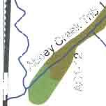
3 Page 3 of 6 Drainage Hazard Areas Drainage Hazard Areas are stream channels that are important for the drainage of large volumes of stormwater. These channels have been determined to be subject to flooding as a result of 25-year storm events. The presence of a DHA requires an engineered hydrology analysis to determine the peak volume and velocity of flow that will travel through the channel given build-out of the up-stream areas of the drainage basin. This determines the width of the DHA. Until this analysis is conducted, the locations of DHAs are identified on county maps with a generic buffer width of 250 feet. The adjacent image shows the DHA buffer associated with Bethany Creek just north of Springville Road. Existing regulations, per CDC Section 421, require a DHA analysis for any proposed development within the 250-foot buffer area. Typically, the first urban development proposal along an identified DHA triggers the required DHA analysis. In the case of Bethany Creek, this may fall to CWS for their preliminary work on locating and sizing regional stormwater facilities. Floodplain Areas Floodplain areas are mapped to generally indicate the limits of flooding for typical 100-year flood events. The maps depict a known flood elevation based on best available topographic and flood information. Any proposed development within 250 feet of the mapped floodplain area is required to perform a sitespecific delineation of the floodplain elevation in order to assure that development is sufficiently outside of the flood-prone area. The adjacent image shows the floodplain area in the vicinity of North Bethany.

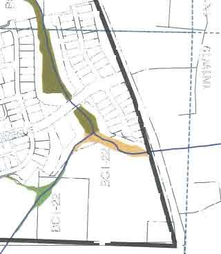
4 Page 4 of 6 The county participates in the federal flood insurance program that involves the federal government s concurrence with the county s maps and development regulations. Clean Water Services assumes a primary administrative role in the regulation of floodplain areas given the importance of these features in the management of storm events. As the Tualatin River Basin has developed over time, the watershed s hydrology has evolved. This is one reason federal flood insurance maps are periodically updated. Clean Water Services recently coordinated with the federal flood insurance program to revise floodplain maps for the Tualatin River basin; these were submitted for federal review in Wetlands and Adjacent Buffer Areas Jurisdictional wetlands are regulated by the Oregon Department of State Lands (DSL). Not all wetland areas are known; many are discovered as part of the site development process. The adjacent image shows wetlands in North Bethany that were known prior to the start of the concept planning work (based on the National Wetland Inventory, or NWI). Additional wetlands may be present; these areas would be identified through more specific site evaluation. State and federal law provides a definition for determining the presence of a wetland, as well as a standard methodology for the identification of significant wetland areas. In Oregon, wetlands are Goal 5 resources. Neither the county s nor the Metro-Tualatin Basin s Goal 5 programs include a wetland element. The adoption of urban land use designations in North Bethany triggers the application of the Goal 5 Administrative Rule. The Goal 5 Rule requires local governments to conduct a local wetlands inventory (LWI) 2, adopt the LWI, make a significance determination [per ORS (3)(b)] and adopt a list of significant wetlands. For significant wetlands, local governments must complete an ESEE analysis (to weigh the environmental, social, energy and economic consequences of allowing conflicting uses) and adopt a program pursuant to OAR and The program must require notification to DSL concerning permits or land use decisions affecting inventoried wetlands [OAR (7)]. 2 LWI Standards and Guidelines are outlined under OAR The LWI is subject to approval by DSL; it is to be used in place of National Wetland Inventory and can be used for Goal 5 purposes.

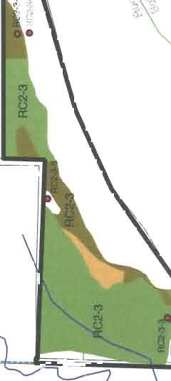
5 Page 5 of 6 A LWI determines the presence of wetlands based on wetland determinations; a standard methodology for this is provided in state law 3. Subsequent delineation locates the specific wetland area on a given site; this typically occurs as part of a development request. A LWI for North Bethany was completed by PHS in February The attached image shows a draft map of the wetlands identified through that process. The inventory is undergoing a concurrence review by DSL to determine whether or not the inventory and methodology are consistent with what is required by law. Development near wetlands identified in the LWI and protected through the ESEE analysis will be subject to county Goal 5 standards for wetlands. In addition, CWS D&C standards apply to these wetlands and others delineated at the development review stage. Under CWS D&C Standards, wetlands are considered water quality sensitive areas for the management of water quality and quantity. Buffer areas are important to protect both of these wetland functions and therefore are regulated by CWS. Under the CWS program, buffer areas associated with streams are called vegetated corridors. Vegetation is an important buffer feature and any nearby development triggers the enhancement of vegetation if it is in a condition that is considered to be less than good. Significant Fish & Wildlife Habitat for Riparian Corridors These Goal 5 elements are covered under the county s existing program and the adopted Metro- Tualatin Basin Goal 5 program (also known as Nature In Neighborhoods). The Concept Plan for North Bethany Subarea does not propose any changes to the Metro-Tualatin Basin program. In North Bethany, applicability of the county s Goal 5 existing program is limited to primarily the Bethany Creek corridor, identified as a Water Areas & Wetlands and Fish & Wildlife Habitat in the Bethany Community Plan and as shown in the adjacent image. The dark blue color shown on the Significant Natural and Cultural Resources Maps indicates the standard 200- foot buffer width which, under CDC Section 422, requires a biologist s Wildlife 3 The required function and condition assessment of mapped wetlands must use the Oregon Freshwater Wetland Assessment Methodology (OFWAM, DSL 1996). This was used by Pacific Habitat Services for North Bethany area wetland determination. This method provides information for planning purposes on the location of potentially regulated wetlands but is not of sufficient detail for permitting purposes under the state Removal-Fill Law (ORS through ).
6 Page 6 of 6 Habitat Assessment (WHA), delineation of the resource area and findings that the proposed development impacts will not seriously interfere with habitat function. While in practice, map amendments to the dark blue color are not common, the WHA is essentially a refinement of those mapped boundaries. For North Bethany, the only program adjustment will be the refinement of this dark blue designation, based on more specific site information. The biologist assessment will be addressed as part of Ordinance No. 730 so that a more specific delineation of the habitat resource can be depicted on the adopted map. This is similar to what was done as part of the plan amendment for what is now the Arbor Oaks Subarea area via Ordinance No (The Ord. 546 process actually refined the delineation to distinguish between resource types, resulting in both dark blue and light blue colors on the amended map.) In effect, CDC Section 422 will be addressed through the ordinance process and will result in protection of the habitat area by including those areas in a no build district on the adopted plan. The preliminary habitat assessment is pending. It therefore will not be necessary for future residential development on adjacent lands to address CDC Section 422. Exceptions to this will be the two planned road crossings. Impacts associated with the crossings and necessary culvert installations will be addressed as part of the development review for requests that include each of the local streets/stream crossings. Attachment
7
8 North Bethany Facilitated Workgroup Process Overview of Meeting Topics to Address Outstanding Issues for 2010 Ordinance Group 1: Natural Resources / Open Spaces Meeting Meeting Purpose Agenda Topics Materials Provided in Advance / at Meeting #1: April 27 Address facilitation preliminaries Describe various analyses that have been conducted to provide more specific site information for North Bethany than is typical for other areas of the county Provide a foundation upon which to discuss future meeting topics by explaining existing county regulations and how they apply to the North Bethany Subarea 1. Welcome and Introductions 2. Meeting Agenda, Ground Rules and Procedures 3. Overview of Issue List and Objectives for Workgroup #1 4. Planning-Level Site Analyses 5. Existing Natural Resource Areas and Regulations Fact Sheet No. 8: North Bethany Subarea Stream Corridors: Existing Regulations (incl. map images) Series of annotated North Bethany Subarea maps highlighting locations of existing regulation areas for existing programs Composite map showing overlap among applicable regulation areas #2 May 13 Describe which additional Goal 5 requirements applicable to North Bethany are required under the Goal 5 Administrative Rule Get feedback on proposed solution for addressing significant wetland areas, including process for determining more accurate boundaries on-site 1. Required Goal 5 Update: Wetlands and Open Spaces 2. Determine Preferred Land Use Designations for Wetland Corridors 3. Development Standards and Review Procedures for Wetland Corridors Annotated North Bethany Subarea maps showing new resources mapped as part of North Bethany Concept Planning. Discuss case study for a disputed site along Bethany Creek Possible Fact Sheet explaining required Goal 5 update. o:\workgroups\workgroup 1\grp1_mtg1_materials_042710\group1mtg_overview.doc
9 Meeting Meeting Purpose Agenda Topics Materials Provided in Advance / at Meeting #3 May 20 Describe objectives for incorporating new site data and requirements on steep slopes and potential landslide hazard areas; discuss options for implementing appropriate land use standards 1. Steep Slopes Land Use Designation and Development Standards 2. Potential Landslide Hazard Area Development Standards Fact Sheet No. 5: Potential Landslide Hazard Areas Fact Sheet No. 15: Update to Grading Standards Senior Planner Paul Schaefer and County Building Division staff to attend this meeting and present on grading and landslide issues #4 June 3 Introduce and resolve outstanding issue related to the intent and design of the parks program 1. Park Location Criteria and Flexibility Fact Sheet No. 13: Park Location Objectives, Flexibility and Approval Criteria acronyms used: CWS = Clean Water Services ESEE = Economic, Social, Environmental and Energy consequences analysis (part go Goal 5 OAR) THPRD = Tualatin Hills Park & Recreation District o:\workgroups\workgroup 1\grp1_mtg1_materials_042710\group1mtg_overview.doc
STREAM BUFFERS
 88-415 STREAM BUFFERS 88-415-01 PURPOSE In the Kansas City region and throughout the nation, vegetated stream buffers have been clearly shown to protect stream stability and related infrastructure, improve
WASHINGTON COUNTY OREGON
 WASHINGTON COUNTY OREGON July 9, 2009 Revisions to Chapter 2 of the Bethany Community Plan The North Bethany Subarea Plan Exhibit pages 7 and 8 The sections for the Core and Flexible Streets were amended
HAZARD MITIGATION GOALS AND OBJECTIVES
 SEWRPC Community Assistance Planning Report No. 282, 2nd Edition CITY OF MILWAUKEE ALL HAZARDS MITIGATION PLAN UPDATE Chapter IV HAZARD MITIGATION GOALS AND OBJECTIVES [NOTE: Throughout this plan update
Staff will be providing an overview of the project need, purpose and intent for consideration as part of the Amendment cycle.
 Agenda Item D-2 City of Tacoma Planning and Development Services To: Planning Commission From: Stephen Atkinson, Planning Services Division Subject: Open Space Corridors Project Meeting Date: March 1,
When planning stormwater management facilities, the following principles shall be applied where possible.
 2.0 Principles When planning stormwater management facilities, the following principles shall be applied where possible. 2.0.1 Drainage is a regional phenomenon that does not respect the boundaries between
Working Group Meeting
 April 4,, 2017 Parks Operations Bldg Working Group Meeting Arts Districts Overview Stormwater/RPA/Stream Considerations First Principles Agenda 7:00pm 7:05pm 7:10pm 7:40pm 8:30pm 9:40pm 9:45pm Welcome
Stormwater Regulations & Considerations Morse Study Area. Pam Fortun, P.E. CFM Senior Stormwater Treatment Engineer Engineering Services Division
 Stormwater Regulations & Considerations Morse Study Area Pam Fortun, P.E. CFM Senior Stormwater Treatment Engineer Engineering Services Division Stormwater Regulations Development Considerations Floodplain
DRAFT MAP AMENDMENT FLU 04-4
 DRAFT MAP AMENDMENT FLU 04-4 SW 24 TH AVENUE ROADWAY CORRIDOR The University of Florida participates with the Metropolitan Transportation Planning Organization (MTPO) in its responsibilities for the continuing,
City of Waco Stormwater Management Regulations
 1.0 Applicability: City of Waco Stormwater Management Regulations These regulations apply to all development within the limits of the City of Waco as well as to any subdivisions within the extra territorial
Appendix E Preliminary Location Hydraulic Study
 Appendix E Prepared for: State of Alaska Department of Transportation and Public Facilities Prepared by: HDR Alaska, Inc. 2525 C Street, Suite 305 Anchorage, Alaska 99503 February 2014 This page intentionally
Zoning Ordinance Chapter 10
 CHAPTER 10 - WASHES SECTION 10.0 GENERAL: A. The purpose of this Ordinance is to establish standards for development in or near Major and Minor Washes as defined in Appendix A Glossary of Terms and Definitions
Shoreline Master Program Town of La Conner, Washington
 Shoreline Master Program Town of La Conner, Washington Department of Ecology approval effective Adopted September 24, 2013 by Town of La Conner Ordinance No.1106 Amended May 13, 2014 by Town of La Conner
Zoning Ordinance Article 3
 Article 3 Natural Resources Protection Section 301 Natural Resources Protection 301.1. Purpose - The following natural resources protection standards are established to protect the public health, safety
TOWNSHIP OF LOGAN SOIL & FILL IMPORTATION AND PLACEMENT APPLICATION SUBMITTAL CHECKLIST
 TOWNSHIP OF LOGAN SOIL & FILL IMPORTATION AND PLACEMENT APPLICATION SUBMITTAL CHECKLIST Applications: 5 copies of application - Applicant will reproduce the copies at his/her costs. The Township Clerk
Conservation Corridor Base and Thematic Maps
 Conservation Corridor Base and Thematic Maps August 20, 2010 This project is funded in part by the Virginia Coastal Zone Management Program at the Department of Environmental Quality through Grant #NAO9NOS4190163
Chapter 4 - Preparation of Stormwater Site Plans
 Chapter 4 - Preparation of Stormwater Site Plans The Stormwater Site Plan is the comprehensive report containing all of the technical information and analysis necessary for the City to evaluate a proposed
SENSITIVE LANDS OVERLAY
 SENSITIVE LANDS OVERLAY Chapter 22 Sensitive Lands Overlay 22.1 PURPOSE 22.2 APPLICATION AND ANALYSIS REQUIREMENTS 22.3 SENSITIVE LAND REGULATIONS 22.4 ADMINISTRATIVE PROVISIONS 22.5 DESIGN STANDARDS 22.6
Existing Conditions and Environmental Consequences Floodplains
 3.9 Environmental Consequences 3.8 3.8.1 WHAT ARE FLOODPLAINS? are low-lying areas adjacent to rivers, streams, and other waterbodies that are susceptible to inundation (flooding) during rain events. These
AMENDMENT NO. 30 TO THE OFFICIAL PLAN OF THE TOWN OF MILTON
 AMENDMENT NO. 30 TO THE OFFICIAL PLAN OF THE TOWN OF MILTON Subject: Boyne Survey Secondary Plan and Related Official Plan Amendments The following text and schedules constitute Amendment No. 30 to the
Vaughan Metropolitan Centre (VMC) Black Creek Renewal CLASS ENVIRONMENTAL ASSESSMENT
 Black Creek Renewal CLASS ENVIRONMENTAL ASSESSMENT") PUBLIC INFORMATION CENTRE Vaughan Metropolitan Centre (VMC) Black Creek Renewal Wednesday, May 10, 2017 6:00 p.m. to 8:00 p.m. Add photo Project Management, Environmental Assessment, Stormwater Management
PUBLIC INFORMATION CENTRE Vaughan Metropolitan Centre (VMC) Black Creek Renewal Wednesday, May 10, 2017 6:00 p.m. to 8:00 p.m. Add photo Project Management, Environmental Assessment, Stormwater Management
NORTH BETHANY ELEMENTARY SCHOOL SITE ASSESSMENT
 NORTH BETHANY ELEMENTARY SCHOOL SITE ASSESSMENT Prepared for: Prepared by: October 10, 2014 Page 2 Introduction and Purpose This report provides an assessment of two potential sites for a new elementary
City of East Point Comprehensive Floodplain Management Program
 City of East Point Comprehensive Floodplain Management GAFM 2012, 7 th Annual Technical Conference Reza Aral, CFM, CPESC (City of East Point, GA) Shayne Wood, P.E. (CDM Smith) March, 28, 2012 Agenda Overview
Part 5. Environmental Protection Overlay District Regulations
 Part 5 Environmental Protection Overlay District Regulations Section 501. Statement of Intent. As established through the goals, objectives and policies of the Amity Township Comprehensive Plan, it is
COLVER ROAD INDUSTRIAL CONCEPT PLAN
 COLVER ROAD INDUSTRIAL CONCEPT PLAN A CONCEPTUAL LAND USE AND TRANSPORTATION PLAN FOR TA-4 AN URBAN RESERVE AREA OF THE CITY TALENT City of Talent Adopted by City Council Resolution No., June, 2015 PART
General Location Annex, Rezone & Preliminary Plat Lansdowne Addition, Unit Three
 NEWFOUNDLAND I-5 Agricultural District Subject Site SUNDANCE ANDERSON Single Family Residential CHRISTY PUD Agricultural District Highway Business General Location Annex, Rezone & Preliminary Plat Lansdowne
7th Avenue Creek Master Plan Development Project. City of St. Charles, IL. IAFSM CONFERENCE March 14, 2018 MARKET
 7th Avenue Creek Master Plan Development Project MARKET City of St. Charles, IL IAFSM CONFERENCE March 14, 2018 7 TH AVENUE CREEK PROJECT AREA 2 2008 RAIN EVENT 3 RESIDENTIAL STRUCTURE FLOODING COMMERCIAL
STORMWATER MANAGEMENT CODES ANALYSIS RICHLAND COUNTY, SC SITE PLANNING ROUNDTABLE
 STORMWATER MANAGEMENT CODES ANALYSIS RICHLAND COUNTY, SC SITE PLANNING ROUNDTABLE Codes analyses for each subcommittee were completed to assist participants of the Richland County Site Planning Roundtable.
Chapter 3 Site Planning and Low Impact Development
 CHAPTER 3 Site Planning and Low Impact Development Chapter 3 Site Planning and Low Impact Development 3.0 Introduction The City of Charleston requires that major residential, large commercial (>1 acre),
17.18 SENSITIVE AREAS
 17.18 SENSITIVE AREAS 17.18.010 Purpose...1 17.18.020 Definitions...1 17.18.030 Review Process...1 17.18.040 Sensitive Areas Analysis...2 17.18.050 Standards and Development Plan...3 17.18.060 Geotechnical
Conservation Corridor Planning and Green Infrastructure Themes
 Conservation Corridor Planning and Green Infrastructure Themes Prepared by the Green Infrastructure Center Inc. and the Northern Virginia Regional Commission February 22, 2011 Brief Overview Project Background
DANE COUNTY COMPREHENSIVE PLAN 5-YEAR UPDATE. Madison Area Surveyors March 12, 2014 Resource Protection Corridors
 DANE COUNTY COMPREHENSIVE PLAN 5-YEAR UPDATE Madison Area Surveyors March 12, 2014 Resource Protection Corridors Resource Protection Corridors Part 1: Purposes and Concepts Resource Protection Corridors
THREE-STEP DESIGN PROCESS FOR OPEN SPACE SUBDIVISIONS
 00216106.DOC NMA/RRK 1/30/14 THREE-STEP DESIGN PROCESS FOR OPEN SPACE SUBDIVISIONS Open space subdivisions, sometimes called cluster developments, maintain a significant portion of a development site in
Descriptive Summary of the Comprehensive Plan Amendment
 Applicant City of Virginia Beach Public Hearing October 12, 2016 2016 Comprehensive Plan Amendment Establishing the Historic Seatack & Vicinity Suburban Focus Area (SFA) in Chapter 1, Section 1.3 Agenda
Location. Need GOAL 14 URBAN GROWTH BOUNDARY. Urban Planning in Oregon 7/8/2015
 Urban Planning in Oregon June 24, 2015 Redmond, Oregon Gordon Howard, DLCD Urban Planning Specialist GOAL 14 URBAN GROWTH BOUNDARY To provide for an orderly and efficient transition from rural to urban
City of Tacoma Planning and Development Services
 Agenda Item D-1 City of Tacoma Planning and Development Services To: Planning Commission From: Elliott Barnett, Planning Services Division Subject: Application #2014-08 Open Space Element Update Meeting
Checklists. Project Name: Location: File Number: Date of Submittal: Reviewer: Date: Applicant: Contact Name: Phone Number:
 Applicant: Contact Name: Phone Number: Email: Project Name: Location: File Number: Date of Submittal: Reviewer: Date: Concept Plan Requirements: I. General Project Information 1. Address or parcel number
Draft Rhode Island Stormwater Design and Installation Standards Manual
 Draft Rhode Island Stormwater Design and Installation Standards Manual Summary The May 2009 Public Review Draft version of the RI Stormwater Design and Installation Standards Manual consists of approximately
Riparian Buffer on the Bushkill Creek. Policies
 Riparian Buffer on the Bushkill Creek Riparian buffers provide numerous benefits to landowners and the community by protecting groundwater recharge areas, providing flood control, providing stormwater
Pennsylvania Stormwater Best Management Practices Manual. Chapter 1. Introduction and Purpose
 Pennsylvania Stormwater Best Management Practices Manual Chapter 1 Introduction and Purpose Chapter 1 Introduction and Purpose 1.1 Purpose of this Manual 1 1.2 How to Use this Manual...1 1.3 Overview
Chapter 1: General Program Information
 Chapter 1: General Program Information 1.1 Introduction The Montgomery County Stormwater Management Resolution (#03-1-5) was adopted by the County Board of Commissioners on January 22, 2003. The purpose
CAO Update Status Work continues on products: Draft ordinance BAS report CAO process summary (2002 to present) Comprehensive e Plan policy review Some
 Comprehensive e Plan policy review Some") Critical Areas Ordinance Update Wetlands Andrew Deffobis Jeremy Davis Cynthia Wilson Thurston County Planning April 6, 2011 CAO Update Status Work continues on products: Draft ordinance BAS report CAO
Critical Areas Ordinance Update Wetlands Andrew Deffobis Jeremy Davis Cynthia Wilson Thurston County Planning April 6, 2011 CAO Update Status Work continues on products: Draft ordinance BAS report CAO
Problem Understanding
 Introduction...2-1 Previous Data and Mapping...2-2 Known Problem Areas...2-3 Resident Survey.2-3 Introduction The Village of Downers Grove stormwater system includes storm sewers, streams, wetlands, roadway
PURPOSE: The purpose is to provide commercial facilities in the Vancouver and Clark County vicinity.
 US Army Corps of Engineers Seattle District Joint Public Notice Application for a Department of the Army Permit and a Washington Department of Ecology Water Quality Certification and/or Coastal Zone Management
Chesapeake Bay Critical Area Conservation Plan
 The Maryland-National Capital Park and Planning Commission Prince George s County Planning Department Development Review Division 301-952-3530 Note: Staff reports can be accessed at www.mncppc.org/pgco/planning/plan.htm.
ST. MARY S SOIL CONSERVATION DISTRICT (SMSCD) AND DPW&T CONCEPT EROSION AND SEDIMENT CONTROL AND STORMWATER MANAGEMENT GUIDELINES AND CHECKLIST
 AND DPW&T CONCEPT EROSION AND SEDIMENT CONTROL AND STORMWATER MANAGEMENT GUIDELINES AND CHECKLIST") St. Mary s Soil Conservation District 26737 Radio Station Way, Suite B Leonardtown, MD 20650 Phone: 301-475-8402 ext. 3 Fax: 301-475-8391 www.stmarysscd.com St. Mary s County Government Department of Public
St. Mary s Soil Conservation District 26737 Radio Station Way, Suite B Leonardtown, MD 20650 Phone: 301-475-8402 ext. 3 Fax: 301-475-8391 www.stmarysscd.com St. Mary s County Government Department of Public
CLACKAMAS COUNTY ZONING AND DEVELOPMENT ORDINANCE
 704 RIVER AND STREAM CONSERVATION AREA (RSCA) 704.01 PURPOSE Section 704 is adopted to: A. Maintain the integrity of the rivers and streams in the County by minimizing erosion, promoting bank stability,
Site Plan Review Residential Accessory Building
 COMMUNITY DEVELOPMENT DEPARTMENT Planning Division P.O. Box 490 333 Broadalbin Street SW Albany, OR 97321 Phone (541) 917-7550 Fax (541) 917-7598 www.cityofalbany.net Site Plan Review Residential Accessory
ARTICLE 6: Special and Planned Development Districts
 ARTICLE 6: Special and Planned Development Districts 6-10 Traditional Neighborhood Development (TND) District 6-10.10 Purpose and Intent The Traditional Neighborhood Development (TND) District provides
Parks, Trails, and Open space Element
 Parks, Trails, and Open space Element Parks, Trails, and Open Space element Parks, Recreation, and Open Space are important components of the quality of life desired by the residents of Elk Grove. This
PCE PRELIMINARY DRAINAGE ANALYSIS REPORT FOR WESTWOOD MIXED USE NEIGHBORHOOD PROJECT 772 NORTH FOREST ROAD TOWN OF AMHERST, ERIE COUNTY, NEW YORK
 PCE PRELIMINARY DRAINAGE ANALYSIS REPORT FOR WESTWOOD MIXED USE NEIGHBORHOOD PROJECT 772 NORTH FOREST ROAD TOWN OF AMHERST, ERIE COUNTY, NEW YORK MAY 19, 2014 Prepared By: Timothy M. Lavocat, P.E., CFM
Parks, Trails, and Open Space Element
 P arks, Recreation, and Open Space are important components of the quality of life desired by the residents of Elk Grove. This Element of the General Plan addresses the City s goals, policies, and actions
County of Fairfax, Virginia
 County of Fairfax, Virginia To protect and enrich the quality of life for the people, neighborhoods and diverse communities of Fairfax County TO: SUBJECT: All Architects, Builders, Developers, Engineers,
TO: Port of Orcas FROM: Tina Whitman, Science Director SUBJECT: Master Plan Update DATE: September 7, 2018
 TO: Port of Orcas FROM: Tina Whitman, Science Director SUBJECT: Master Plan Update DATE: September 7, 2018 Friends of the San Juans appreciates the opportunity to provide input to the Port of Orcas Master
CONSERVATION ELEMENT GOALS, OBJECTIVES, AND POLICIES
 CONSERVATION ELEMENT GOALS, OBJECTIVES, AND POLICIES Goal 4 To conserve, manage, appropriately use and protect the natural resources of the City ensuring continued resource availability and environmental
Town of Peru Comprehensive Plan Executive Summary
 Town of Peru Comprehensive Plan Executive Communities that plan grow by choice, not by chance. A plan makes growth thoughtful, understandable, and predictable. A plan shows that a community is managing
PROJECT BACKGROUND. Preliminary Design Scope and Tasks
 PROJECT BACKGROUND Preliminary Design Scope and Tasks The purpose of this Study is the development of preliminary designs for intersection improvements for Trunk Highway (TH) 36 at the intersections of
Section 3 Non-Structural BMPs
 3.1 Stream Buffers A stream buffer or stream setback is a designated area around a stream, lake, or wetland left in a natural, densely vegetated state so as to protect the receiving water quality and provide
Clackamas County Comprehensive Plan. Chapter 4: LAND USE
 Chapter 4: LAND USE When the pioneers settled Clackamas County, the land resource appeared infinite. They cleared forest, carved towns from the wilderness, and used waterways as the arterials of commerce.
Westbound: A One-day Exploration of Growth
 Westbound: A One-day Exploration of Growth Frog Pond Area 2018 UGB Expansion Proposal June 13, 2018 Growing Out: UGB Asks Four cities submitted proposals to expand greater Portland s urban footprint by
POLICY 41, URBAN GROWTH BOUNDARY EXPANSIONS:
 POLICY 41, URBAN GROWTH BOUNDARY EXPANSIONS: It is the policy of Washington County to ensure an efficient and effective transition of rural land to urban development when an Urban Growth Boundary (UGB)
COUNTY COUNCIL OF PRINCE GEORGE'S COUNTY, MARYLAND SITTING AS THE DISTRICT COUNCIL 2010 Legislative Session. Council Members Dernoga and Olson
 DR- COUNTY COUNCIL OF PRINCE GEORGE'S COUNTY, MARYLAND SITTING AS THE DISTRICT COUNCIL 00 Legislative Session Bill No. CB--00 Chapter No. Proposed and Presented by Introduced by Co-Sponsors The Chairman
Drexel, Barrell & Co.
 Drexel, Barrell & Co. June 18, 2018 Engineers/Surveyors Boulder Colorado Springs Greeley 3 South 7 th Street Colorado Springs, Colorado 80905-1501 719 260-0887 719 260-8352 Fax El Paso County Planning
Northern Branch Corridor DEIS December 2011
 16 Floodplains 161 Chapter Overview 1611 Introduction The flowing chapter identifies floodplains found within the Northern Branch Corridor in accordance with Executive Order 11988, Floodplain Management
INTRODUCTION PLANNING HISTORY
 INTRODUCTION The Upper Rock Creek Master Plan Area lies in the east central part of Montgomery County. The Master Plan Area is adjacent to the City of Rockville to the south, the Olney Planning Area to
NORTHEAST RIVER CROSSING FUNCTIONAL PLANNING STUDY
 WELCOME Northeast River Crossing Functional Planning Study Phase 2 Public Meeting 4 to 8 PM Informal drop-in format and discussion tables Meeting Purpose Introduce the Northeast River Crossing Functional
TOWN OF BETHLEHEM MEETING SUMMARY LOCAL WATERFRONT REVITALIZATION PROGRAM UPDATE
 TOWN OF BETHLEHEM LOCAL WATERFRONT REVITALIZATION PROGRAM UPDATE MEETING SUMMARY Purpose: LWRP Update Public Workshop #3 Date and Time: October 24, 2017, 6:00 pm - 8:00 pm Location: Town Hall, 445 Delaware
CITY OF TIGARD EXPECTED SERVICE AREA
 CITY OF TIGARD EXPECTED SERVICE AREA City overview / Background Incorporated in 1961, the has experienced rapid growth over the years. This growth can be attributed to many factors, primarily the close
Lower Meramec Multi-Jurisdictional Floodplain Management Plan Public Involvement (Results of Early Public Engagement) 27 June 2018
 27 June 2018") Lower Meramec Multi-Jurisdictional Floodplain Management Plan Public Involvement (Results of Early Public Engagement) 27 June 2018 Public Involvement Summary: The planning process includes opportunities
Lower Meramec Multi-Jurisdictional Floodplain Management Plan Public Involvement (Results of Early Public Engagement) 27 June 2018 Public Involvement Summary: The planning process includes opportunities
7.0 SOCIAL, ECONOMIC, AND ENVIRONMENTAL ISSUES
 7.0 SOCIAL, ECONOMIC, AND ENVIRONMENTAL ISSUES The following list of social, economic, and environmental issues have been identified based on a preliminary inventory of resources in the project area, an
CHARLES COUNTY GOVERNMENT RFP NO POPES CREEK RAIL TRAIL DESIGN
 CHARLES COUNTY GOVERNMENT Department of Fiscal and Administrative Services Purchasing Division Telephone: 301-645-0656 July 7, 2015 RFP NO. 16-02 POPES CREEK RAIL TRAIL DESIGN ADDENDUM NUMBER ONE TO: All
Chapter 5: Natural Resources and Environment
 NATURAL RESOURCES AND ENVIRONMENT 5-1 5 Chapter 5: Natural Resources and Environment BACKGROUND AND INTENT Urban expansion represents the greatest risk for the future degradation of existing natural areas,
North Bethany Subarea Plan
 North Bethany Subarea Plan Washington County A-Engrossed Land Use Ordinance No. 739 9/28/2011 September 30, 2011 Page 2 require the Vegetation Buffer with Fencing along the eastern perimeter to put the
A larger version of this map is located on the last page of this PDF.
 MAP Committee Input McLoughlin Area Draft Vision Map A larger version of this map is located on the last page of this PDF. 1. The map above is intended to portray a vision for the McLoughlin area. It highlights
STORMWATER GREEN INFRASTRUCTURE AND PLANNING/ZONING BOARDS
 STORMWATER GREEN INFRASTRUCTURE AND PLANNING/ZONING BOARDS Source: Center for Watershed Protection, 2007 Southern Tier Central Regional Planning & Development Board Chemung County Stormwater Team OUTLINE
ALL SECURE SELF STORAGE SEPA APPEAL RECOMMENDATION TO THE HEARING EXAMINER
 KITSAP COUNTY DEPARTMENT OF COMMUNITY DEVELOPMENT 619 DIVISION STREET MS-36, PORT ORCHARD WASHINGTON 98366-4682 LOUISA GARBO, DIRECTOR (360) 337-5777 FAX (360) 337-4415 HOME PAGE - www.kitsapgov.com ALL
Venice Pumping Plant Dual Force Main Project Draft EIR
 City of Los Angeles 5.9 LAND USE PLANS 5.9.1 Environmental Setting Venice Pumping Plant Dual Force Main Project Draft EIR The Project lies within the bounds of Los Angeles County and the City of Los Angeles.
Sanford/Lee County Technical Review Committee (TRC) DEADLINES & MEETING DATES
 DEADLINES & MEETING DATES") Sanford/Lee County Technical Review Committee (TRC) DEADLINES & MEETING DATES The following 2019 information is based on the information available to staff at the time of creation. Dates & time may change
Sanford/Lee County Technical Review Committee (TRC) DEADLINES & MEETING DATES The following 2019 information is based on the information available to staff at the time of creation. Dates & time may change
CITY COUNCIL AGENDA REPORT
 CITY COUNCIL AGENDA REPORT Subject: DESIGNATED FLOOD LINE CARROT CREEK Recommendation(s) That Administration bring forward a Land Use Bylaw amendment in October 2014 establishing the Designated Flood Line
CITY OF SCANDIA ORDINANCE NO. 174
 CITY OF SCANDIA ORDINANCE NO. 174 AN ORDINANCE AMENDING ORDINANCE NO. 122, THE SCANDIA DEVELOPMENT CODE, CHAPTER 2, SECTION 4.34, REGARDING SOLAR FARMS AND COMMUNITY SOLAR GARDENS The City Council of the
SUMMARY. Support the Southeast Arkansas Regional Intermodal Facility.
 SUMMARY THE I-69 LOCATION STUDY The proposed I-69 Location Study from El Dorado to McGehee, Arkansas, represents one section (Section of Independent Utility No. 13) of the nationally designated I-69 Corridor
Lower Don River West Remedial Flood Protection Project TABLE OF CONTENTS. Page. Executive Summary
 TABLE OF CONTENTS Page Executive Summary 1.0 INTRODUCTION...1-1 1.1 Purpose of the Undertaking...1-1 1.2 Study Area Description...1-1 1.3 Description of the Undertaking...1-1 1.4 Rationale for the Undertaking...1-2
Washington County, Maryland Division of Public Works Policy Manual
 Washington County, Maryland Division of Public Works Policy Manual Subject: Downstream Drainage Easement Category: Land Development Engineering Number: 7-4.1 Date: June 1, 2009 (effective) PURPOSE: The
SECTION II SECTION II STATEMENT OF GOALS, OBJECTIVES, PRINCIPLES, ASSUMPTIONS, POLICIES AND STANDARDS
 STATEMENT OF GOALS, OBJECTIVES, PRINCIPLES, ASSUMPTIONS, POLICIES AND STANDARDS 1 2 STATEMENT OF GOALS, OBJECTIVES, PRINCIPLES, ASSUMPTIONS, POLICIES AND STANDARDS INTRODUCTION The New Jersey Municipal
PRELIMINARY CONDITIONAL USE SUBMITTAL CHECKLIST REQUIREMENTS
 This checklist must accompany your submittal as the cover page. CONDITIONAL USE Application Submittal Checklist for PRELIMINARY AND FINAL APPROVAL Per Winter Park Land Development Code Sec. 58-90 PRELIMINARY
Note: Staff reports can be accessed at Zone: I-3. Tier:
 The Maryland-National Capital Park and Planning Commission Prince George s County Planning Department Development Review Division 301-952-3530 Note: Staff reports can be accessed at www.mncppc.org/pgco/planning/plan.htm.
GENERAL LAND USE PLAN ELEMENT
 CITY OF Prepared by City of Medford Planning Department 200 South Ivy Street Medford, Oregon 97501 plnmed@ci.medford.or.us James E. Huber, AICP, Planning Director COMPREHENSIVE PLANNING SECTION John Adam,
APPENDIX 1: SCOPED ENVIRONMENTAL IMPACT STATEMENT (EIS) FORM
 FORM") APPENDIX 1: SCOPED ENVIRONMENTAL IMPACT STATEMENT (EIS) FORM This form is intended for use by applicants (primarily private landowners) who need to conduct a Scoped EIS in support of minor development
APPENDIX 1: SCOPED ENVIRONMENTAL IMPACT STATEMENT (EIS) FORM This form is intended for use by applicants (primarily private landowners) who need to conduct a Scoped EIS in support of minor development
Table of Contents TABLE OF CONTENTS SECTION TITLE PAGE
 TABLE OF CONTENTS SECTION TITLE PAGE 1 INTRODUCTION AND OVERVIEW 1-1 1.1 Purpose and Need 1-1 1.2 Goals and Objectives 1-3 1.3 Overview of the Planning Process 1-5 1.4 Federal and State Requirements and
26/Old Dominion Task Force
 26/Old Dominion Task Force Meeting #9: March 21, 2019 Study Area Overview Staff Name, Department (DEPT ACRONYM) Preferred Scenarios Outline 1. Task Force Feedback from 3/7 2. Refined Concepts 3. Implementation
I. STAFF POLICY RECOMMENDATIONS. The following RMP policy strategies are proposed by staff in support of a Scenic Resource Protection Program:
 Policy Consideration: Scenic Resource Protection Program Status: For Consideration by the Highlands Council at September 14, 2006 Work session Date: September 12, 2006 I. STAFF POLICY RECOMMENDATIONS The
Drexel, Barrell & Co.
 Drexel, Barrell & Co. December 21, 2018 Engineers/Surveyors Boulder Colorado Springs Greeley 3 South 7 th Street Colorado Springs, Colorado 80905-1501 719 260-0887 719 260-8352 Fax El Paso County Planning
Mitchell Ranch South MPUD Application for Master Planned Unit Development Approval Project Narrative. Introduction
 Mitchell Ranch South MPUD Application for Master Planned Unit Development Approval Project Narrative Introduction Mitchell Ranch South is a proposed single family (detached) residential development on
Chapter 10 IMPLEMENTATION RECOMMENDATIONS
 Chapter 10 IMPLEMENTATION RECOMMENDATIONS The recommended land use plan presented in the previous chapter provides a design for the attainment of the urban and rural development and open space preservation
WILLIAM STREET STORM SEWER OUTFALL. PUBLIC INFORMATION CENTRE March 23, 2017
 WILLIAM STREET STORM SEWER OUTFALL Municipal Class Environmental Assessment PUBLIC INFORMATION CENTRE March 23, 2017 ACCESSIBILITY Under the Accessibility Standards 2015 for Customer Service Regulation
Environmental Protection Ordinances (Performance Zoning) Bedminster Township, Bucks County
 Bedminster Township, Bucks County") Environmental Protection Ordinances (Performance Zoning) Bedminster Township, Bucks County ARTICLE VI. PERFORMANCE STANDARDS Section 600 Compliance All uses, activities, subdivisions and/or land developments
Environmental Protection Ordinances (Performance Zoning) Bedminster Township, Bucks County ARTICLE VI. PERFORMANCE STANDARDS Section 600 Compliance All uses, activities, subdivisions and/or land developments
Richton Park Western Development Corridor Green Infrastructure Development Plan August 18, 2017
 Richton Park Western Development Corridor Green Infrastructure Development Plan August 18, 2017 Conservation Design Forum Geosyntec Consultants 403 W. St. Charles Road 1420 Kensington Road, Suite 103 Lombard,
Appendix I. Checklists
 Appendix I Checklists Town of Greenwich Drainage Manual Department of Public Works - Engineering Division Town Hall - 101 Field Point Road, Greenwich, CT 06836-2540 Phone 203-622-7767 - Fax 203-622-7747
Highlands Region Stormwater Management Program Guidance
 DRAFT Highlands Region Stormwater Management Program Guidance Release Date: January 2016 Abstract This guidance document provides an overview of the Highlands Stormwater Management Program. It is intended
STORMWATER SITE PLAN INSTRUCTIONS AND SUBMITTAL TEMPLATE Medium and Large Projects
 DEPARTMENT OF COMMUNITY DEVELOPMENT 621 Sheridan Street, Port Townsend, WA 98368 Tel: 360.379.4450 Fax: 360.379.4451 Web: www.co.jefferson.wa.us/communitydevelopment E-mail: dcd@co.jefferson.wa.us STORMWATER
Rule D Wetland and Creek Buffers
 Rule D Wetland and Creek Buffers 1 Policy It is the policy of the Board of Managers to ensure the preservation of the natural resources, recreational, habitat, water treatment and water storage functions