Green Infrastructure Planning for Sustainability and Resiliency
|
|
|
- Valerie Walters
- 5 years ago
- Views:
Transcription

1 Green Infrastructure Planning for Sustainability and Resiliency Linking Lands and Communities in the Land-of-Sky Region SAMAB Conference - November 18, Linda Giltz, AICP, Regional Planner linda@landofsky.org

2 Outline Intro to region Growth and climate change challenges Linking Lands and Communities project Designing resiliency into the Regional Network Planning for climate change using the LLC framework next steps


3 Multi-county, local government planning and development organization (Council of Governments) Council board is made up of chief elected officials from member governments, economic development representatives and others Council s mission: to work with local governments, the Region s leadership and state and federal agencies to foster desirable social, economic, cultural and ecological conditions in Buncombe, Henderson, Madison and Transylvania Counties. For more information, see

4 Western NC and the Land-of-Sky Region
5 Natural History & Resources Rugged Mountains Fertile Valleys French Broad River 1,867 sq. miles Rich Biodiversity Globally Outstanding Ecoregion


6 Challenges Facing Our Region Steady population growth; Spread-out pattern of growth 450, , , , , , , ,000 50, Development on mountain ridges and steep slopes is breaking up large parcels of mostly forested land, resulting in habitat loss, loss of scenic quality, water quality issues, Need to preserve rich biodiversity


7 Mapping historical development patterns and forecasting urban growth in Western North Carolina, The Center for Applied GIScience at UNC Charlotte, 2009.

8 Satellite imagery from 1976, 1985, 1995 and 2006 used to track the advance of impervious surfaces, a key indicator of development. Projections of development potential were constructed from statistical models using variables that help predict growth patterns: distance to roads, interchanges and urban areas; the attraction of employment centers; slope; and pressure from previously developed areas.

9 Challenges Facing our Region Loss of Farmland and Farming Approx. 16% of land is farmland; 86,000 acres lost between 1987 and 2007 Fragmentation into smaller parcels; Loss of rural lifestyle and character. Agriculture key to local economy and to region s resiliency


10 Climate Change Expected Impacts Water Flooding Drought Decreased availability Agriculture Changes in crops and growing seasons Changes in tree species More loss due to fire Humans, Communities Stress due to increased air and water temps Sever weather events Degraded ecosystem services Wildlife Habitat & Biodiversity Changes in sizes and locations of habitat Species adaptation, migration or extinction


11 The Challenges of Growing Communities Communities need tools to make strategic and informed land use decisions Where to encourage development? Which lands to conserve? Where to construct roads & utilities? To bring together divergent interests!

12 Linking Lands and Communities Goals Identify where the most valuable natural resources are located and how they might be interconnected; Bring together a diverse group of organizations and individuals to explore common values and identify opportunities to work together to maintain our valued resources; Provide a set of tools and resources to help local governments and communities make more informed land use and development decisions.
13 Project Partners Appalachian Sustainable Agriculture Project (ASAP) Appalachian Trail Conservancy Friends of DuPont State Forest NC Wildlife Federation Open Space Institute RiverLink Southern Appalachian Forest Coalition Southern Environmental Law Center Sustainable Big Ivy WNC Green Building Council Western North Carolina Alliance Asheville Convention and Visitors Bureau The Biltmore Estate Mountain Council for Accountable Development Self Help Credit Union/Self Help Ventures Fund Sustainability Strategies, LLC NC Cooperative Extension County Offices NC Department of Agriculture NC Department of Environment and Natural Resources NC Division of Community Assistance NC Division of Forest Resources NC Farm Bureau NCSU Mountain Horticultural Crops Research & Ext Center NC Wildlife Resources Commission Buncombe County Buncombe County Greenways and Trails Commission Buncombe County Soil & Water Conservation District City of Asheville City of Hendersonville Transylvania County Blue Ridge Forever Carolina Mountain Land Conservancy Southern Appalachian Highlands Conservancy Blue Ridge National Heritage Area Blue Ridge Parkway Natural Resources Conservation Service U.S.D.A. Forest Service Southern Research Station U.S. Fish & Wildlife Service Mars Hill College UNC Asheville UNC Asheville Warren Wilson College

14 Project Funding $$ The Community Foundation of Western North Carolina Blue Ridge National Heritage Area Federal Highway Administration RENCI at UNC Asheville Z. Smith Reynolds Foundation Lyndhurst Foundation Wildlife Conservation Society


15 Why a Regional Network Approach? Nature functions as a system that does not match or respect jurisdictional boundaries Healthy natural systems provide valuable goods and services for the health and well-being our communities


16 Benefits that people obtain from healthy natural systems Clean water and air Food Timber Pollination of crops and other vegetation Flood and drought mitigation Soil formation and maintenance Recreation and aesthetic and spiritual benefits

17 Economic Benefits - Ecosystem Services Storm water management Lands preserved for flood storage have an 8:1 dollar savings over manmade flood control structures Supplying drinking water 105 of world s biggest cities rely on protected forests for drinking water (e.g. NYC - $1.5 billion to protect watershed vs. $6-8 billion).


18 HOW we are developing the network Using a community- and sciencebased approach Green Infrastructure planning: Is a nationally recognized collaborative method for land use planning, and designed to meet the needs of ALL stakeholders. is not an advocacy tool designed to favor a specific point of view Focus is on interconnectivity and the importance of having a network

19 Green Infrastructure is our region s Natural Life Support System an interconnected network of land and water that contributes to the health, economic well being & quality of life for communities & people. A Green Infrastructure Network may include: Natural areas Public and private conservation lands Farmlands and lands managed for forestry Outdoor recreation areas and trails Cultural resources and sites Green Infrastructure networks exist at various scales (parcel, community, regional)


20 What are the most valuable resources in the region? Water and water quality Farming and forestry Cultural heritage Scenic views Recreation Wildlife habitat and biodiversity 20
21 Project Staff from Land-of-Sky Regional Council Leadership Group Guides network priorities based on scientific recommendations & community values and plays key role in outreach and implementation Science Team Conduct ecological assessments and make recommendations for the network based on sound science. Recreation Sub-Committee Cultural Resources Sub-Committee Outreach & Implementation Sub- Committee Agriculture Assessment Working Group Wildlife Habitat & Biodiversity Working Group Water Quality Working Group
22 Resource Assessments Water Quality Which lands are valuable for their contribution to water quality? Agriculture Which lands are valuable for farming and forestry? Wildlife Habitat & Biodiversity Which lands are valuable for wildlife habitat and supporting & maintaining biodiversity? The Green Infrastructure Network is developed by using the highest priority lands identified in these assessments 22
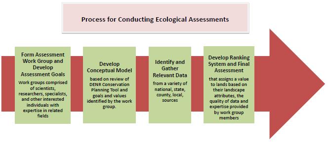
23 For each assessment:


24 Assessment Approach/Standards Assessments and ranking criteria developed by each working group Raster based modeling (30- meter pixels) Ordinal ranking scale of 1-10 Use the most current and accurate data available Data incorporated must be region-wide
 have productive soils AND have forest or cropland")
25 Primary Indicators of High Value Lands: Presence of an existing farm/forest operation Land Cover Vegetation Type Most productive soils Highest Ranking Lands (10) have productive soils AND have forest or cropland vegetation
26 Primary Indicators of High Value Lands: Sub-watersheds that: are primarily forested have some level of protection contains a water supply watershed contain a stream rated good or excellent by DWQ
27 The WHB Assessment identifies lands that: 1.Provide large blocks of natural habitat 2.Support high levels of biodiversity 3.Support priority ecological systems as identified in the NC State Wildlife Action Plan developed by the Wildlife Resources Commission 4.Provide associated ecosystem services and functions to local communities. 27
28 Identifying Resource Hubs Highest ranking lands (ranks 7-10) Minimum size criteria >= 100 acres Combined with public and protected lands


29 Network Design driven by Landscape Ecology Principles larger hubs are better than smaller hubs; one large hub is better than multiple smaller hubs with the same total area; more compact hubs are better than less compact hubs; connected hubs are better than isolated hubs.
30 Contribution to Green Infrastructure Network: Agricultural Resource Hubs 30
31 Contribution to Green Infrastructure Network: Water Quality Hubs 31
32 Contribution to Green Infrastructure Network: Wildlife Habitat and Biodiversity Hubs and Corridors 32
 from each assessment")
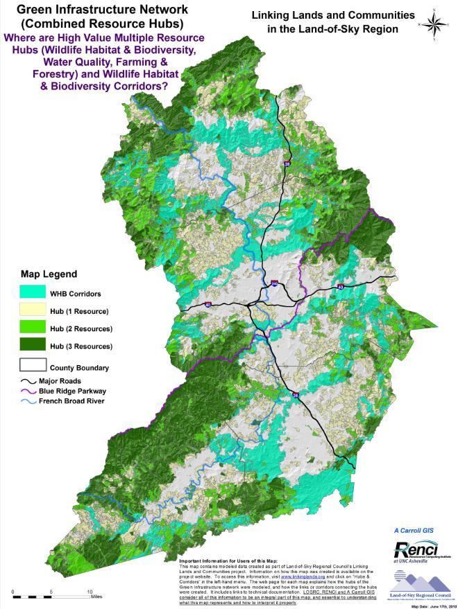
33 Combined Resource Hubs Lands with multiple resource values Combined highest ranking lands (7-10) from each assessment 33

34 Wildlife Habitat & Biodiversity Corridors 12 sources chosen from hubs along perimeter Corridors contains lands of high ecological value provide areas for plant and animal species to move as climate changes
35 35
36 Hub and Corridor Evaluation: Habitat Suites Hubs and proposed corridors contain: - 91% of all natural habitat above 4,000 ft - 74% of all forested riparian habitat - 70% of all natural habitat below 4,000 ft -25% of all agricultural and open space
37 Hub and Corridor Evaluation: Natural Heritage Data 74% of EO source points captured in WHBD hubs and corridors Fragmented or isolated populations represent remaining 26% of source points

38 Implementation / Action Series of actions that bring the GI network into reality on the ground and manage it in sustainable ways Resource planning; Conservation; Restoration; Development; and Management Management practices key to implementation


39 Variety of Implementers Local Governments State and Federal Agencies Land Owners Developers Land Trusts Environmental and other Non-profits
40 Variety of actions examples: A county uses the tools in its Comprehensive Plan update and/or its Development Review process Developer uses the tools to ID best orientation and layout for a planned subdivision NCDOT and MPO use the tools to mitigate negative impacts of intersection improvements upon wildlife crossings NCDOT and MPO use the tools to help identify best new alignment for a road NC Wildlife Federation works with a developer to facilitate a Wildlife- Friendly Development Certification A greenways commission uses the tools to plan a regional greenway A land trust uses the tools to prioritize key agricultural lands for protection The USFS uses the tools to make resource management decisions The NCWRC uses the tools to prioritize land management practices for a newly-acquired gamelands tract A developer uses the tools to gain regional credit for LEED certification of his/her project


41 Implementation Resources Linking Lands and Communities Data, Maps, Information State Government Resources NC Div. of Community Assistance County Planning and Permitting Offices Local, Regional and Statewide Land Trusts Studies, Toolkits, Best Management Practices Quality Growth Toolbox Mountain Landscapes Initiative

42 For Transportation Planning and Mitigation


43 To Support City/County Planning Additional data, maps and tools to enhance current data and planning tools Provides additional information for planning for conservation, recreation and development


44 Structuring zoning and development ordinances to conserve priority habitats alongside development Minimum 25% of site must be in permanent conservation Priority on floodplains, stream buffers and slopes >30% Density bonus for greater open space OR agricultural preservation Must submit management plan

45 Development Review & Site Design Using the GI network, LLC assessments and other conservation data to review development proposals Applying wildlife-friendly development principles to site design

46 Development Review & Site Design

47 Land Trust Example Use the tools to prioritize lands for agricultural preservation: Look at the Agricultural Hubs map Look at the GI network map Look at the various layers included in the Agricultural Assessment; then seek out other data and resources
48


49 Communication & Outreach Provide informational materials and promote use of products maps, documentation, website, fact sheets Presentations to a variety of groups Training workshops


50 Next steps Share project and process with other regions Update data as new data are available Design various development scenarios and compare development needs to natural resource priorities and needs Design regional climate change scenarios and examine impacts ID a set of best practices that increase resilience of resources, ecosystems
51 Questions? Discussion Project website: Land-of-Sky website:
National Association of Conservation Districts. Kris Hoellen Vice President, Sustainable Programs The Conservation Fund September 19, 2013
 National Association of Conservation Districts Kris Hoellen Vice President, Sustainable Programs The Conservation Fund September 19, 2013 Our Mission The Conservation Fund forges partnerships to conserve
Green Infrastructure Policies and Ordinances
 Green Infrastructure Policies and Ordinances October 23, 2013 By Karen Firehock, Green Infrastructure Center 2013 Georgia Urban Forest Council s 23 rd Annual Conference The mission of the nonprofit Green
Preface. Erie. Scranton. Allentown. Pittsburgh. Harrisburg. Philadelphia
 The Southern Alleghenies Region The Southern Alleghenies Region spans the Laurel Highlands and Allegheny Front in the west across the Appalachians to the east. It is comprised of Blair, Bedford, Cambria,
Presentation Outcomes
 Green Infrastructure Rappahannock-Rapidan Living Lands Planning Workshop September 17, 2009 Presentation Outcomes Define green infrastructure principles and concepts (video). How are green infrastructure
Green Infrastructure. by Karen Engel, NYS DEC. NYS Department of Environmental Conservation
 Green Infrastructure by Karen Engel, NYS DEC What is Green Infrastructure? For some it s all about water Green Infrastructure techniques use soils and vegetation to infiltrate, evapotranspirate, and/or
Town of Peru Comprehensive Plan Executive Summary
 Town of Peru Comprehensive Plan Executive Communities that plan grow by choice, not by chance. A plan makes growth thoughtful, understandable, and predictable. A plan shows that a community is managing
CHAPTER 1 Introduction
 CHAPTER 1 Introduction From sea to summit, Lane County covers almost 4,800 square miles of diverse Oregon landscape. Stretching from the Pacific Ocean through the Coastal Range, the Willamette Valley to
Blue/Green Infrastructure Study Accomack County, VA
 Blue/Green Infrastructure Study Accomack County, VA Draft Asset Maps March 8-9, 2010 Green Infrastructure Center, Inc. 2 Overview What is Green and Blue Infrastructure Project Timeline & Tasks Literature
Statewide Greenways Vision
 Greenways Vision The formation of a greenways vision is based on a thorough analysis of the current state of recreation and open space in a region and the existing pressures that threaten it. Lehigh and
Countywide Green Infrastructure
 Montgomery County s Countywide Green Infrastructure F U N C T I O N A L M A S T E R P L A N The Maryland National Capital Park and Planning Commission INFRASTRUCTURE An underlying base or foundation especially
Rural Land Use Designations Kittitas County December 6, 2007 Draft
 KITTITAS COUNTY COMMUNITY DEVELOPMENT SERVICES 411 N. Ruby St., Suite 2, Ellensburg, WA 98926 CDS@CO.KITTITAS.WA.US Office (509) 962-7506 Fax (509) 962-7682 Rural Land Use Designations Kittitas County
Map Development 5/15/2012. New Virginia Modeling Tools
 Regional Green Infrastructure Base Map Development 5/15/2012 RRRC Land Use & Environment Committee New Virginia Modeling Tools VA Natural Landscape Assessment Forest Habitats Cultural Model Historic Resources
RECREATION, OPEN SPACE AND GREENWAYS ELEMENT GOALS, OBJECTIVES, AND POLICIES
 RECREATION, OPEN SPACE AND GREENWAYS ELEMENT GOALS, OBJECTIVES, AND POLICIES GOAL R-1: DEVELOP A RECREATION, OPEN SPACE AND GREENWAYS SYSTEM AS AN INTEGRAL COMPONENT OF AN OVERALL, COUNTY-WIDE ECONOMIC
Chapter 1 Vision Statement & Goals
 Chapter 1 Section 1.1 Section 1.2 Section 1.3 Section 1.4 Section 1.5 Introduction Vision Statement Visioning Exercise Prioritization of Land Use Issues Goals of the Comprehensive Plan CHAPTER 1 SECTION
Exhibit A. 8:9 Scuffletown Rural Conservation District
 Exhibit A 8:9 Scuffletown Rural Conservation District 8:9.1 Intent and Purpose The Scuffletown Rural Conservation (SRC) District is intended to provide for residential development that supports the development
This page intentionally blank.
 This page intentionally blank. Parks, Recreation, and Open Space Chapter Relationship to Vision Vision Parks, Recreation and Open Space Chapter Concepts County Government. County government that is accountable
Regional Context Statement
 Regional Context Statement REGIONAL CONTEXT STATEMENT 3. REGIONAL CONTEXT STATEMENT In 1995, the Provincial Government passed into law the Growth Strategies Act. The purpose of this provincial initiative
Middle Mississippi River. Regional Corridor
 Middle Mississippi River St. Louis District Regional Corridor Lessons Learned from a Collaborative Planning Study Brian Johnson US Army Corps of Engineers 12 th Biennial Governor s Conference on the Management
Carrboro Greenways Commission January 9 th, 2007
 Carrboro Greenways Commission January 9 th, 2007 Statewide The flooding of Crabtree Valley in the early 1970 s (right before Crabtree Valley Mall was set to open) caused city, state, and federal officials
IMPLEMENTING SOMERSET COUNTY S INVESTMENT FRAMEWORK
 IMPLEMENTING SOMERSET COUNTY S INVESTMENT FRAMEWORK SMART CONSERVATION THROUGH SMART GROWTH NJ LAND CONSERVATION RALLY March 22, 2014 Laurette Kratina, PP, AICP, Supervising Planner Somerset County Planning
SUSTAINABILITY PLAN OTTAWA COUNTY PARKS AND RECREATION COMMISSION FALL 2017
 SUSTAINABILITY PLAN OTTAWA COUNTY PARKS AND RECREATION COMMISSION FALL 2017 Table of Contents Introduction Natural Resources Quality of Life Community Continuing the Mission Sustainability Measuring Sustainability
Conservation Corridor Planning and Green Infrastructure Themes
 Conservation Corridor Planning and Green Infrastructure Themes Prepared by the Green Infrastructure Center Inc. and the Northern Virginia Regional Commission February 22, 2011 Brief Overview Project Background
2014 South Atlantic LCC
 2014 South Atlantic LCC Annual Report 1 Allie Stewart, U.S. FWS The South Atlantic LCC s 2014 Annual Report this year of progress and accomplishments is dedicated to South Atlantic LCC Coordinator, Ken
Photo by Carlton Ward Jr. Executive Summary
 Photo by Carlton Ward Jr. Executive Summary The Cooperative Conservation Blueprint (Blueprint) is a multi-partner strategic conservation process developed by the Florida Fish and Wildlife Commission (FWC)
CALGARY: City of Animals Edited by Jim Ellis
 CALGARY: City of Animals Edited by Jim Ellis ISBN 978-1-55238-968-3 THIS BOOK IS AN OPEN ACCESS E-BOOK. It is an electronic version of a book that can be purchased in physical form through any bookseller
FUTURES: Regional Growth Modeling for NC Building a FUTURES Forecasting Model for the Triangle and Rocky Mount Regions
 FUTURES: Regional Growth Modeling for NC Building a FUTURES Forecasting Model for the Triangle and Rocky Mount Regions Presented by: Jeff Michael, RENCI at UNC Charlotte John Vogler, UNCC Center for Applied
EXECUTIVE SUMMARY DRAFT CHAPTER 1 INTRODUCTION EXECUTIVE SUMMARY
 CHAPTER 1 EXECUTIVE SUMMARY INTRODUCTION Through the joint efforts of the City of Tulsa planning staff and the Land Services division of Indian Nations Council of Governments (INCOG), the Berryhill Land
Henderson County Project Prioritization Discussion
 French Broad River MPO Henderson County Project Prioritization Discussion A discussion on projects considered for MPO Local Input Points in the tier for P 5.0 French Broad River MPO 8-8-2018 INTRODUCTION
Member Service Plan Sierra Nevada AmeriCorps Partnership
 Member Service Plan Sierra Nevada AmeriCorps Partnership Service plans lay the framework for what each Member will be doing during their service. Service plans detail the major projects and expected results
HALIFAX GREEN NETWORK PLAN
 HALIFAX GREEN NETWORK PLAN Community Planning & Economic Development Standing Committee June 21, 2018 Photo credit: Vlastimil Koutecky, Flickr Creative Commons HGNP PROCESS PHASE 1 FOUNDATIONS PHASE 2
4. What are the goals of the Kawarthas, Naturally Connected project? 7. What are watersheds and why are they being used as the project boundaries?
 Frequently Asked Questions (FAQs) 1. What are Natural Heritage Systems (NHS)? 2. Why are they important? 3. Which areas of the province have undertaken NHS projects? 4. What are the goals of the Kawarthas,
Green Infrastructure. NYS Department of Environmental Conservation
 Green Infrastructure Green infrastructure is an interconnected network of natural areas and open spaces that sustains ecosystems. Benedict, M.A. and E.T. McMahon. 2006. Green Infrastructure Linking Landscapes
Planning for Staten. Habitat Restoration and Green Infrastructure. Island s North Shore
 Habitat Restoration and Green Infrastructure Planning for Staten Island s North Shore Community Board 1 March 1, 2018 NYC Parks Forestry, Horticulture, and Natural Resources Funded by the NYS Department
Overview of Southwestern Pennsylvania Commission s (SPC) 2040 Long Range Transportation Plan (LRTP)
 2040 Long Range Transportation Plan (LRTP)") Overview of Southwestern Pennsylvania Commission s (SPC) 2040 Long Range Transportation Plan (LRTP) Presented to Pennsylvania Agency Coordination Meeting May 27, 2015 Doug Smith & Ryan Gordon 1 Southwestern
Overview of Southwestern Pennsylvania Commission s (SPC) 2040 Long Range Transportation Plan (LRTP) Presented to Pennsylvania Agency Coordination Meeting May 27, 2015 Doug Smith & Ryan Gordon 1 Southwestern
THREE-STEP DESIGN PROCESS FOR OPEN SPACE SUBDIVISIONS
 00216106.DOC NMA/RRK 1/30/14 THREE-STEP DESIGN PROCESS FOR OPEN SPACE SUBDIVISIONS Open space subdivisions, sometimes called cluster developments, maintain a significant portion of a development site in
STEWARDSHIP OF LONG ISLAND SOUND S ECOLOGICAL AND RECREATIONAL RESOURCES
 STEWARDSHIP OF LONG ISLAND SOUND S ECOLOGICAL AND RECREATIONAL RESOURCES Robin Kriesberg, Save the Sound, Inc. Thomas Halavik, US Fish and Wildlife Service Coastal Program An Initiative to Identify, Protect
Parks, Open Space and Trails
 Introduction Parks have often been referred as the lungs of our cities, cleansing the air of pollutants and particulate matter. Parks are also gathering places for families and community. They offer spaces
Innovative Land Use Techniques
 Innovative Land Use Techniques A Handbook for Sustainable Development Eric Williams, Assistant Administrator, NHDES Carolyn Russell, Principal Planner, NHDES Cliff Sinnott, Executive Director, RPC Jill
1 Introduction. Chapter. In this chapter:
 Chapter 1 Introduction In this chapter: 1.1 A Snapshot of the Region 1.2 Towards a Sustainable Region 1.3 The Provincial Context 1.4 Purpose and Organization The Regional Municipality of York Official
Section 4 BUILDING THE MASTER PLAN
 The Master Plan 33 Section 4 BUILDING THE MASTER PLAN Figure 4:1. A collaborative effort characterized the two design workshops sponsored by DISC to create hypothetical Master Plans for the Towers Property
SALISBURY TOMORROW Our Vision
 SALISBURY TOMORROW Our Vision Salisbury is committed to supporting a high quality of life and sense of community for all residents. These commitments need to be reflected in our community programs, services
Minnesota Department of Natural Resource - Natural Resource Guidance Checklist Conserving Natural Resources through Density Bonuses
 Minnesota Department of Natural Resource - Natural Resource Guidance Checklist Conserving Natural Resources through Density Bonuses NRDB Why Use Density Bonuses & This Checklist Local units of government
TOWN OF BETHLEHEM OPEN SPACE CONSERVATION PLAN PUBLIC MEETING: OCTOBER 12, 2017
 TOWN OF BETHLEHEM OPEN SPACE CONSERVATION PLAN PUBLIC MEETING: OCTOBER 12, 2017 Welcome and Agenda 6:00 6:45: Open House, Part One 6:45 7:15: Presentation and Questions 7:15 8:00: Open House, Part Two
Applicant Name Phone / Fax / Address City State Zip Code . Property Owner Phone / Fax / Address City State Zip Code
 Master Development Plan Application Community Development Department City of Redmond 411 SW 9 th Street Redmond, Oregon 97756 541-923-7721 541-548-0706 FAX Master Development Plan Fee $38,862.52 File Number
CHAPTER 7: Transportation, Mobility and Circulation
 AGLE AREA COMMUNITY Plan CHAPTER 7 CHAPTER 7: Transportation, Mobility and Circulation Transportation, Mobility and Circulation The purpose of the Transportation, Mobility and Circulation Chapter is to
CHAPTER 4 FUTURE LAND USE AND URBAN SERVICES DISTRICTS
 CHAPTER 4 FUTURE LAND USE AND URBAN SERVICES DISTRICTS Introduction This chapter discusses how Benzie County should grow and change in the future. A community can grow and change in many different ways.
GIS to Estimate Archaeological Site Loss and Develop Conservation Strategies
 GIS to Estimate Archaeological Site Loss and Develop Conservation Strategies Terry Jackson Office of Decision Support Systems Planning and Environmental Management Division Georgia Department of Community
New Official Plan Quest November 2013
 City of Markham New Official Plan Quest November 2013 Building Markham s Future Together - 6 Key Strategic Priorities 1. Growth - Managing our Growth 2. Transportation/Transit - Improving transportation
Riparian Buffer on the Bushkill Creek. Policies
 Riparian Buffer on the Bushkill Creek Riparian buffers provide numerous benefits to landowners and the community by protecting groundwater recharge areas, providing flood control, providing stormwater
Chapter 5: Natural Resources and Environment
 NATURAL RESOURCES AND ENVIRONMENT 5-1 5 Chapter 5: Natural Resources and Environment BACKGROUND AND INTENT Urban expansion represents the greatest risk for the future degradation of existing natural areas,
Virginia DCR- Natural Heritage Program. Tools for Linking Conservation and Transportation Planning
 Virginia DCR- Natural Heritage Program Tools for Linking Conservation and Transportation Planning November 9, 2009 MISSION: to conserve Virginia's biodiversity through statewide biological inventory, protection,
COMMUNITY ENVIRONMENTAL MANAGEMENT
 COMMUNITY ENVIRONMENTAL MANAGEMENT CEM HANDBOOK FOR COMMUNITY CONSERVATION PLANNING ----- Draft ----- Prepared by the CENTER FOR COMMUNITY ENVIRONMENTAL MANAGEMENT in association with the NEW YORK STATE
Large Landscape Restoration and the National Park System
 National Park Service U.S. Department of the Interior Large Landscape Restoration and the National Park System April 21, 2016 National Conference on Ecosystem Restoration Raymond M. Sauvajot, Ph.D. Associate
Conservation Development
 Acknowledgements RIDEM: Scott Millar Anthony Lachowicz-Planning and Zoning Consultant Director of Planning 1 : a creative land use technique that allows a community to guide growth to the most appropriate
Whitemarsh Township Greenway Plan
 Whitemarsh Township Greenway Plan Prepared for: Whitemarsh Township August 16, 2007 Table of Contents Table of Contents... i Introduction... 1 Study Area Setting... 2 Regional Setting... 2 Township Character...
Cooperative Extension s Role in Land Use Planning and Conservation. Sabrina Drill UCCE- Los Angeles/Ventura Integrated Hardwood Range Mgmt.
 Cooperative Extension s Role in Land Use Planning and Conservation Sabrina Drill UCCE- Los Angeles/Ventura Integrated Hardwood Range Mgmt. Program Cooperative Extension Land Grant Universities: 1862 Agricultural
KEEPING IT GREEN IN THE MIDLANDS: Preserving Open Space in South Carolina s Capitol Region
 KEEPING IT GREEN IN THE MIDLANDS: Preserving Open Space in South Carolina s Capitol Region Introduction The Central Midlands Council of Governments (CMCOG) has been working to produce a concept document
Remi Mendoza City Planning Academy March 13, 2017
 Remi Mendoza City Planning Academy March 13, 2017 1 What is the General Plan? The 2030 General Plan 5-Year Update (2035 General Plan) Questions and Answers 2 Guidebook for development and growth Required
TERRESTRIAL NATURAL HERITAGE SYSTEM STRATEGY APPENDIX F: MODEL POLICIES FOR THE IMPLEMENTATION OF THE TARGET TERRESTRIAL NATURAL HERITAGE SYSTEM
 TERRESTRIAL NATURAL HERITAGE SYSTEM STRATEGY APPENDIX F: MODEL POLICIES FOR THE IMPLEMENTATION OF THE TARGET TERRESTRIAL NATURAL HERITAGE SYSTEM C H A P T E R 1 M O D E L P O L I C I E S F O R I M P L
City of Brevard 2015 Comprehensive Plan
 City of Brevard 2015 Comprehensive Plan Plan Functional Elements Arts & Culture Brevard enjoys a rich mix of artistic and cultural resources, from music venues to historic sites to multi-day festivals.
MAYFIELD WEST SECONDARY PLAN PHASE 2
 MAYFIELD WEST SECONDARY PLAN PHASE 2 Public Open House #3 February 25, 2010 Draft Preferred Land Use Scenario TOWN OF CALEDON PLANNING & DEVELOPMENT DEPARTMENT Open House Agenda TOWN OF CALEDON 1. Welcome
EC Conference on Green Infrastructure Green Infrastructure Applications in the U.S. Kris Hoellen, The Conservation Fund
 EC Conference on Green Infrastructure Green Infrastructure Applications in the U.S. Kris Hoellen, The Conservation Fund The Conservation Fund Partners in Land & Water Conservation Mission & Program Areas
PSRC REVIEW REPORT & CERTIFICATION RECOMMENDATION
 PSRC REVIEW REPORT & CERTIFICATION RECOMMENDATION KITSAP COUNTY COUNTYWIDE PLANNING POLICIES July 2, 2012 BACKGROUND A major emphasis of the Washington State Growth Management Act (GMA) is the need to
DRAFT FOR PUBLIC REVIEW. Game Plan for a Healthy City
 DRAFT FOR PUBLIC REVIEW 2018 Game Plan for a Healthy City 2 Denveright. Parks & Recreation Game Plan Draft for Public Review Draft for Public Review Executive Summary Game Plan Overview Executive Summary
Portage County Parks, Trails and Greenways Plan
 Portage County Parks, Trails and Greenways Plan Agenda for Local Planning Meeting Introductory Presentation Why we need a Plan Plan project goals and process Benefits Overview of local planning region
Figure 1. Proposed Strategic Habitat Conservation Areas for Florida
 Figure 1. Proposed Strategic Habitat Conservation Areas for Florida Critical Lands and Waters Identification Project (CLIP) Cooperative Effort Century Commission for Sustainable Florida Florida Natural
LAND USE Land Use 219
 3.2 2040 LAND USE One purpose of the 2040 Plan is to provide a public policy basis for making decisions regarding growth and development in the County. The number, size, and complexity of land use proposals
Rural Conservation. Rural Conservation. Moving Forward ~ Planning Ahead. Introduction
 Introduction Minnehaha County expresses at least two very different styles of character. The City of Sioux Falls provides a strong urban atmosphere because of its size and regional status, and the unincorporated
One County s Success in Linking Watershed Protection and Land Use Planning
 One County s Success in Linking Watershed Protection and Land Use Planning Bob Thompson Porter County Plan Commission March 28, 2012 Indiana Watershed Leadership Academy Population 160,000 Approximately
IV. Development in the Rural Overlay District
 Intracoastal Waterway Route 17 Route 168 Great Dismal Swamp VIRGINIA NORTH CAROLINA IV. Development in the Rural Overlay District IV-1 Route 17 in Chesapeake s Rural Overlay District affords distant views
I. STAFF POLICY RECOMMENDATIONS. The following RMP policy strategies are proposed by staff in support of a Scenic Resource Protection Program:
 Policy Consideration: Scenic Resource Protection Program Status: For Consideration by the Highlands Council at September 14, 2006 Work session Date: September 12, 2006 I. STAFF POLICY RECOMMENDATIONS The
Working Group Meeting
 April 4,, 2017 Parks Operations Bldg Working Group Meeting Arts Districts Overview Stormwater/RPA/Stream Considerations First Principles Agenda 7:00pm 7:05pm 7:10pm 7:40pm 8:30pm 9:40pm 9:45pm Welcome
WASHINGTON COUNTY OREGON
 WASHINGTON COUNTY OREGON LONG RANGE PLANNING DIVISION North Bethany Subarea Stream Corridors: Existing Regulations In Oregon, there is a distinct difference between the land use rules that apply in rural
GREEN INFRASTRUCTURE for the U.S.
 GREEN INFRASTRUCTURE for the U.S. Maps and Apps to connect the most valuable landscapes in the nation By Arancha Munoz-Criado Green Infrastructure for the U.S. 1 2 Green Infrastructure for the U.S. What
Green Infrastructure Mapping Exercise
 Green Infrastructure Mapping Exercise One Water Summit March 3, 2017 Mead Mier Sustainability Coordinator, Watershed Planning Lead Josh Pope GIS Manager Pima Association of Governments Outline What is
Colorado Outdoor Partnership
 Colorado Outdoor Partnership Quick Facts 2017 SHIFT Award Winner Public Land Management Innovation Category Year Founded: 2016 Member agencies and organizations: 32 Executive Summit Coalition The Problem:
3. VISION AND GOALS. Vision Statement. Goals, Objectives and Policies
 Vision Statement Queen Creek s interconnected network of parks, trails, open spaces and recreation opportunities provide safe and diverse activities and programs that sustain its unique, small town, equestrian
Conserving Illinois North Shore Ravines
 Conserving Illinois North Shore Ravines Rebecca Grill, Natural Areas Manager, Park District of Highland Park, rgrill@pdhp.org Jeff Boeckler, Principal Water Resource Specialist, Northwater Consulting,
Policy & Procedure Effective Date: Parks Department Page of
 City of Arvada Policy & Procedure Effective Date: Parks Department Page of TITLE: City of Arvada Prairie Dog Habitat Plan APPROVAL: PURPOSE: To establish a plan for the preservation of black-tailed prairie
PRINCIPLE 6: Preserve open space, farmland, natural beauty, and critical environmental areas
 HOW TO APPLY SMART GROWTH PRINCIPLES TO RURAL COMMUNITIES PRINCIPLE 6: Preserve open space, farmland, natural beauty, and critical environmental areas A product of AND A cooperative publication from the
Florida Forever Conservation Needs Assessment Overview Maps
 Florida Forever Conservation Needs Assessment Overview Maps Prepared by Florida Natural Areas Inventory, The maps in this document are derived from the Florida Forever Conservation Needs Assessment, an
Florida Greenways and Trails System (FGTS) Plan Goals, Strategies and Objectives
 Plan Goals, Strategies and Objectives") Identification and Prioritization of the FGTS The Florida Greenways and Trails System (FGTS) is made up of existing, planned and conceptual trails and ecological greenways that form a connected, integrated
Identification and Prioritization of the FGTS The Florida Greenways and Trails System (FGTS) is made up of existing, planned and conceptual trails and ecological greenways that form a connected, integrated
INTRODUCTION Key Issues and Findings Goals, Objectives, and Policies - Natural Resources - Map M18 - Environmental Resources
 Natural, Environmental, Cu INTRODUCTION This Element provides policies related to the preservation and protection of the Centre Region s natural, environmental, cultural, and historic resources. This Element
Oakland County s Green Infrastructure Vision. L. Brooks Patterson Oakland County Executive
 Oakland County s Green Infrastructure Vision L. Brooks Patterson Oakland County Executive Southeast Michigan 20 miles northwest of Detroit Consists of 910 square miles Population of 1.2 million More than
Office of Greenways & Trails Providing Statewide Leadership and Coordination. Southeast Greenways and Trails Summit October 1-3, 2017
 Office of Greenways & Trails Providing Statewide Leadership and Coordination Southeast Greenways and Trails Summit October 1-3, 2017 1 Office of Greenways and Trails The Office of Greenways and Trails
Arlington, Virginia is a worldclass
 EXECUTIVE S U M M A RY Arlington maintains a rich variety of stable neighborhoods, quality schools and enlightened land use policies, and received the Environmental Protection Agency s highest award for
TOWN OF SPRINGFIELD, NEW HAMPSHIRE
 TOWN OF SPRINGFIELD, NEW HAMPSHIRE NATURAL RESOURCES INVENTORY EXECUTIVE SUMMARY March 2008 Prepared by: Watershed to Wildlife, Inc. Natural Resource Consultants 42 Mill Street, Suite 3 Littleton, NH 03561
Planning for and Managing Open Space and Natural Areas
 Planning for and Managing Open Space and Natural Areas Increasingly, development proposals in Delaware include large amounts of open space and natural areas. While open space is important as a community
Shared History, Shared Future
 Open Space is Shared History, Shared Future Builds upon past and current regional planning: PSP Action Agenda, Vision 2040, the Cascade Agenda, and Mountains to Sound Greenway The ROSS Approach Building
Resolution XII NOTING also that with the increasingly rapid urbanization, wetlands are being threatened in two principle ways:
 12 th Meeting of the Conference of the Parties to the Convention on Wetlands (Ramsar, Iran, 1971) Punta del Este, Uruguay, 1-9 June 2015 Resolution XII.10 Wetland City 1 Accreditation of the Ramsar Convention
Key Elements of Successful Conservation Planning. John Paskus October 17, 2013 Pierce Cedar Creek Institute Michigan Natural Features Inventory
 Key Elements of Successful Conservation Planning John Paskus October 17, 2013 Pierce Cedar Creek Institute Michigan Natural Features Inventory What is Conservation Planning? Pressey et al (2008): The process
2018 Northampton Township Comprehensive Plan
 2018 BUCKS COUNTY, PENNSYLVANIA What is a? A comprehensive plan is a municipality s main policy document that details the collective vision for the future, the historic, environmental, and cultural facilities
OPEN SPACE CHAPTER 7: OVERVIEW. Preserve open space to protect natural resources, enhance character and provide passive recreation opportunities
 CHAPTER 7: OPEN SPACE OVERVIEW Ridgefield has made tremendous progress permanently preserving areas of town as open space. Open space preservation can serve many important purposes, including: protect
3.9 Systems Interrelationships
 191 Sustainability Building Blocks: The Comprehensive Plan Systems Community Form Economy Social Transportation Natural Resources Housing and Neighborhoods Utilities and Infrastructure Institutions.9 Systems
Master Plan Objectives and Policies
 Master Plan Objectives and Policies Introduction This chapter identifies the Park issues and recommended policies established by this Master Plan. The issues were identified through meetings with staff,
Cumberland Region Tomorrow is a private, non-profit, citizen based regional organization working with Greater Nashville Regional Council
 Cumberland Region Tomorrow is a private, non-profit, citizen based regional organization working with Greater Nashville Regional Council and others in the public and private sectors, dedicated to planning
Extension Master Gardener Volunteer Program Information Session. Charlotte Glen, Extension Agent Horticulture NCCE - Chatham County Center
 Extension Master Gardener Volunteer Program Information Session Charlotte Glen, Extension Agent Horticulture NCCE - Chatham County Center Overview What is NC Cooperative Extension? Extension s Horticulture
Conservation Corridor Base and Thematic Maps
 Conservation Corridor Base and Thematic Maps August 20, 2010 This project is funded in part by the Virginia Coastal Zone Management Program at the Department of Environmental Quality through Grant #NAO9NOS4190163
Community Conservation Workshop. Lake Placid
 Community Conservation Workshop Lake Placid 2 Community Conservation Program Welcome! We have designed a Community Conservation Program that listens to the needs of community members. We are conducting
CITY OF LANGLEY OFFICIAL COMMUNITY PLAN BYLAW, 2005, NO APPENDIX II - REGIONAL CONTEXT MAP
 CITY OF LANGLEY OFFICIAL COMMUNITY PLAN BYLAW, 2005, NO. 2600 APPENDIX II - REGIONAL CONTEXT MAP ± Legend Agricultural Mixed Employment Industrial Conservation & Recreation Regional City Centre Urban Containment