Point A Point B Point C Point D. City of Hapeville Public Meeting July 25, 2017
|
|
|
- Debra Parks
- 5 years ago
- Views:
Transcription
1 City of Hapeville Public Meeting July 25, 2017
2 Fulton County Transit Master Plan Overview Following last year s ¾-cent TSPLOST effort, the Mayors of the 14 Cities outside of Atlanta and the Fulton County Commission affirmed that a plan was needed to determine potential expansion of transit services in Fulton County. The Mayors and County approached ARC to help fund and manage the study in collaboration with MARTA, Fulton County, and the 14 participating cities.


3 Fulton County Transit Master Plan Overview Lead Consultants: Point Team D members focused on community outreach and transit funding: The Collaborative Firm/Sycamore Consulting and Boothe Transit
4 Fulton County Transit Master Plan Overview Phase 1 Community Vision and Existing Transit Conditions Phase 2 Scenario Development Phase 3 Transit Master Plan Refinement April - July July - October November - December
5 Public Engagement Public Meetings Online Engagement Key Stakeholder and Population Group Meetings June/July September November/December Ongoing July - December Ongoing June December up to 10 meetings
6 Potential Transit Objectives in Fulton County 1. Provide greater access to employment centers and regional destinations 2. Catalyze economic development, investment and placemaking 3. Provide faster, more reliable mobility and mitigate highway congestion (short-term and long-term)
7 Fulton County Corridors of Interest South Fulton: I-85 South South Fulton Parkway Highway 29 / Roosevelt Highway Norfolk Southern rail line to Clayton Highway 74 North Fulton: Georgia 400 I-285 Holcomb Bridge Road / Highway 92 Old Milton Parkway Highway 141
8 Last Mile Connectivity 1. Perimeter Center and City Springs 2. College Park MARTA rail station 3. East Point MARTA rail station 4. Bus Shelters on existing bus routes 5. Pedestrian crossings on major corridors to more safely access bus stops 6. Park and Ride lots 7. Technology to support evolving modes and transportation management measures
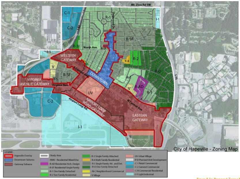
9 Hapeville LCI Study, 2017 TRANSPORTATION HIGHLIGHTS Add and improve sidewalks along both Central Avenues, especially Porsche Avenue (South Central) east of the Hapeville business district Plan for access improvements to potential transit stations on the existing Norfolk Southern Point corridor C Point Explore Dfeasibility of a circulator shuttle to connect the Virginia Avenue-Central Avenue business corridors Combine this shuttle with existing airport shuttle service to create a larger circulator system Work with City of Atlanta and partner agencies on bicycle sharing or short-term rental programs Work with GDOT and City of Atlanta to pursue relocation of State Route 3 from Dogwood Drive and Central Avenue
10 Hapeville LCI Study, 2017 TRANSIT RECOMMENDATIONS The city of Hapeville is encouraged to work closely with MARTA as they continue to develop Point routes Bfor the Clayton County MARTA line. A rail stop in Hapeville could have a positive impact on drawing new employers to the area, and could allow the city to connect to the larger metro Point system. C Coordination with local hotels and the airport shuttle, may provide new opportunities for additional Point D connectivity to downtown Hapeville. Relocating SR-19/US-41 to Cleveland Avenue and I-75 will allow Hapeville to obtain local control of Dogwood Drive and North Central Avenue, allowing the city to design pedestrian oriented streetscapes, wayfinding, and control maintenance.
11


12 Potential Transit in Fulton County Current Modes Under Consideration Heavy Rail Light Rail Bus Rapid Transit (BRT) Bus
13 Current State of Transit: Fulton County MARTA Local Bus (Paratransit corridor within ¾ mile each side of each route below) Northern Region of the County is served by Routes 85, 87, 140, 141, 143 and 185 connecting to North Springs Station Route 148 connecting to Sandy Springs Station, Route 25 connecting to Medical Center Station. Point DSouthern Region of the County is served by: Routes 78, 79, 84, 93, 193, and 194 connecting to East Point Station Routes 82, 89, 172, 180, 181, 189, 195 and 196 connecting to College Park Station Heavy Rail Northern Region of the County is served by: North Springs, Sandy Springs, Dunwoody and Medical Center Stations Southern Region of the County is served by: East Point and College Park Stations
14 Current State of Transit: Fulton County GRTA - Xpress Bus Commuter Service Northern Region of the County is served by: Route 408 originating at Emory Johns Creek Hospital and connecting to MARTA heavy rail at Doraville Station Southern Region of the County is served by: Route 453 originates in Newnan with a stop at the Union City Park Ride lot. This route connects to MARTA heavy rail at Arts Center Station Perimeter Center Shuttle Serves corporate campuses along Glenlake Parkway, Embassy Row and Peachtree Dunwoody corridors, connects to Sandy Springs Station Sanctuary Park Shuttle Serves the corporate campus in Alpharetta, connects to North Springs Station. Fulton County Dial-a-Ride Transportation Services (DARTS) DARTS is an age-based service funded 100% by the Fulton County Board of Commissioners.

15 South Fulton Combined Community Vision
16 Community Input 1. EXAMPLES - Where have you experienced successful transit? 2. ENGAGE - Review existing plans and transit services 3. EVALUATE - What criteria should we use to evaluate potential scenarios? 4. ENHANCE - Where are enhanced transit services needed and what mode is desired?
17 Other Upcoming Community Meetings Alpharetta July 26 Sandy Springs July 27 South Fulton August 1 East Point August 3 Palmetto and Johns Creek Meetings anticipated late summer/fall Visit our website at
REVIEW AND EVALUATION OF REGIONAL LAND USE
 REVIEW AND EVALUATION OF REGIONAL LAND USE AND TRANSPORTATION SCENARIOS #220831 Environmental Justice Task Force October 7, 2014 VISION 2050 Process Development of Guiding Vision for Land Use and Transportation
BeltLine Corridor Environmental Study
 BeltLine Corridor Environmental Study Citywide Conversation on Transit and Trails April 2, 2009 Agenda & Introductions Introductions Environmental Study Process Overview of the BeltLine Project BeltLine
Atlanta BeltLine, Inc. Pathways to Urban Sustainability
 Atlanta BeltLine, Inc. Pathways to Urban Sustainability September 30, 2010 WHAT IS THE ATLANTA BELTLINE? Transit 22-mile loop Parks 1300 + new acres Trails 33 miles Jobs & Economic Development 20 areas,
Draft Plan Recommendations
 Draft Plan Recommendations Sponsored by Henry County and the Atlanta Regional Commission T S W TEAM Tunnell-Spangler-Walsh & Associates URS Corporation Marketek Study Area 1,300 acres Includes parts of
BeltLine Corridor Environmental Study
 BeltLine Corridor Environmental Study Joint TAC and SAC Meeting December 8, 2008 What We Will Discuss Today Outreach and Agency Coordination Scoping Results Existing Conditions Historical and Archeological
Atlanta BeltLine Corridor Environmental Study. Scoping Meeting August 2008
 Atlanta BeltLine Corridor Environmental Study Scoping Meeting August 2008 What Will We Be Discussing Today? Study Overview - How Did We Get Here? - What Is the Study About? - Who Is Involved? - Where Is
South Fulton Parkway Transit Feasibility Study
 South Fulton Parkway Transit Feasibility Study Study Purpose To conduct a high level assessment of potential transit improvements in the South Fulton Parkway Corridor through the evaluation of various
GPA FALL 2017 CONFERENCE
 Change in Doraville Doraville at the beginning of a new era Design Doraville (Comp. Plan) adopted in 2016 Doraville Town Center Masterplan LCI (2005) Downtown Doraville Masterplan LCI (2010) 2014 Adoption
South Davis County COMMUNITY SPOTLIGHT
 South Davis County COMMUNITY SPOTLIGHT Davis/SLC Community Connector Bus Rapid Transit line connecting SLC & Davis County RTP Phase 1 Project Generate 3,100 average weekday riders Relieve congestion on
Date: April 10, 2017 City Council Work Session April 24, 2017: Status Report on the Comprehensive Plan Update and Transportation Master Plan
 AGENDA REPORT To: From: By: Honorable Mayor and City Council Members Warren Hutmacher, City Manager Sharon Ebert, Director Community Development Date: April 10, 2017 Agenda: City Council Work Session April
Gold Line Bus Rapid Transit Transit Oriented Development (BRTOD) Helmo Station Area Plan
 Helmo Station Area Plan") Appendix F Gold Line Bus Rapid Transit Transit Oriented Development (BRTOD) Helmo Station Area Plan Introduction and Purpose of the Plan The Gold Line Bus Rapid Transit facility is an eleven-mile dedicated
Appendix F Gold Line Bus Rapid Transit Transit Oriented Development (BRTOD) Helmo Station Area Plan Introduction and Purpose of the Plan The Gold Line Bus Rapid Transit facility is an eleven-mile dedicated
Knoxville Area Transit (KAT) Transit Development Plan Corridor Analysis
 Transit Development Plan Corridor Analysis") Knoxville Area Transit (KAT) Transit Development Plan Submitted to: Knoxville-Knox County Metropolitan Planning Commission Submitted by: PB Americas, Inc. Under contract to: The Corradino Group, Inc. October
Knoxville Area Transit (KAT) Transit Development Plan Submitted to: Knoxville-Knox County Metropolitan Planning Commission Submitted by: PB Americas, Inc. Under contract to: The Corradino Group, Inc. October
38 Queen s University Campus Master Plan Part 1
 38 Queen s University Campus Master Plan Part 1 46 The Campus at the City Scale Chapter 4 The Campus at the City Scale 39 Queen s is an urban University centrally located in Kingston. Decisions made by
Route 110 Alternatives Analysis
 Route 110 Alternatives Analysis Public Meeting #1 December 15, 2014 Source: Town of Babylon Agenda Welcome/Introduction Hon. Antonio A. Martinez Deputy Supervisor, Town of Babylon Update on East Farmingdale
SCTPO Project Summary September 2014
 A1A MULTIMODAL CORRIDOR PLANNING AND ENGINEERING ANALYSIS Florida Department of Transportation SCTPO Project Summary September 2014 PRESENTATION FOOTER Meeting Agenda What We Plan To Do Project Background
Midtown Greenway Land Use and Development Plan Executive Summary
 Midtown Greenway Land Use and Development Plan Executive Summary Introduction The Midtown Greenway Land Use and Development Plan sets policy direction for land use and development in the Midtown Greenway
Denver Moves: Transit Task Force
 Insert transit picture Denver Moves: Transit Task Force Meeting #8 October 5, 2017 1. Welcome & Introductions Opening remarks and housekeeping Task Force and audience introductions Upcoming events and
2035 General Plan Update and Belmont Village Specific Plan. Joint Study Session with the City Council and Planning Commission April 12, 2016
 2035 General Plan Update and Belmont Village Specific Plan Joint Study with the City Council and Planning Commission April 12, 2016 Agenda 1. Welcome and Introductions 2. General Plan Update Status of
2030 Transit System Plan Refresh
 2030 Transit System Plan Refresh Centers and Corridors Project Connect Growth Concept Map Joint use Task Force CRTPO Technical Coordinating Committee July 6, 2017 City of Charlotte The Origin Story Centers
Transit Implementation Strategy Westside Study Group Meeting
 Westside Study Group Meeting February 27, 2012 The Portland Streetcar Passing Through a Park Near Portland State University Westside Study Group Meeting February 27, 2012 1. TIA Update 2. TIS Process To-Date
CHAPTER 7: Transportation, Mobility and Circulation
 AGLE AREA COMMUNITY Plan CHAPTER 7 CHAPTER 7: Transportation, Mobility and Circulation Transportation, Mobility and Circulation The purpose of the Transportation, Mobility and Circulation Chapter is to
Mountain View & Old Dixie Node Master Plans CLAYTON COUNTY BOARD OF COMMISSIONERS. October 16, 2018
 Mountain View & Old Dixie Node Master lans CLAYTON COUNTY BOARD OF COMMISSIONERS October 16, 2018 Downtown Hapeville MOUNTAIN VIEW Hartsfield-Jackson Atlanta International Airport Mountain View: 750 Acres
SOUTHEAST CORRIDOR EXTENSION. PUBLIC SCOPING MEETING/OPEN HOUSE October 15, 2008
 SOUTHEAST CORRIDOR EXTENSION PUBLIC SCOPING MEETING/OPEN HOUSE October 15, 2008 PROJECT BACKGROUND Project Overview Southeast Light Rail opened 2006 Southeast Corridor/Lone Tree Light Rail Extension Limited
Northwest commuter rail station US 36 BRT. Westminster Station
 Northwest commuter rail station Westminster Station US 36 BRT Westminster Center US 36 & Church Ranch Broomfield Flatiron/96 th St. US 36 & McCaslin Table Mesa Boulder Junction 13-month effort that will
Transportation. Strategies for Action
 Transportation A major priority for the Overlake Neighborhood is to develop a multimodal transportation system. To achieve this system, a balance has to be found among travel, circulation and access needs;
Silver Line Gateway. Extension of Silver Line Bus Rapid Transit (BRT) to Chelsea and East Boston. Public Informational Meeting Chelsea, MA
 to Chelsea and East Boston. Public Informational Meeting Chelsea, MA") Silver Line Gateway Extension of Silver Line Bus Rapid Transit (BRT) to Chelsea and East Boston Public Informational Meeting Chelsea, MA August 18, 2014 Introduction / Design Process Design Team Joe Pavao,
Silver Line Gateway Extension of Silver Line Bus Rapid Transit (BRT) to Chelsea and East Boston Public Informational Meeting Chelsea, MA August 18, 2014 Introduction / Design Process Design Team Joe Pavao,
Application for LCI Supplemental Study FY 2012 Dec. 16, 2011
 Perimeter Community Improvement Districts LCI Supplemental Study FY 2012 Application for LCI Supplemental Study FY 2012 Dec. 16, 2011 Perimeter Community Improvement Districts LCI Supplemental Study FY
NORTH CLAYMONT AREA MASTER PLAN COMMUNITY WORKSHOP #1 FEBRUARY 3, 2016
 NORTH CLAYMONT AREA MASTER PLAN COMMUNITY WORKSHOP #1 FEBRUARY 3, 2016 1. Introduction To the team and to the Plan Planning Partners The Claymont Community WILMAPCO New Castle County Claymont Renaissance
RESOLUTION NO. R Refining the route, profile and stations for the Downtown Redmond Link Extension
 RESOLUTION NO. R2018-32 Refining the route, profile and stations for the Downtown Redmond Link Extension MEETING: DATE: TYPE OF ACTION: STAFF CONTACT: Capital Committee Board PROPOSED ACTION 09/13/2018
POLICY ADVISORY COMMITTEE
 July 26, 2018 POLICY ADVISORY COMMITTEE ENVIRONMENTAL ANALYSIS PHASE Agenda 1. Welcome and introductions. 2. Overview of project activities. 3. Community Advisory Committee update. 4. Public engagement
State Route 6 Corridor Study Final Report
 D R A F T State Route 6 Corridor Study Final Report Atlanta Regional Commission State Route 6 Corridor Study Final Report Prepared for: Atlanta Regional Commission Prepared by: URS Corporation 1000 Abernathy
12/9/2013. HOLLYWOOD/PINES CORRIDOR PROJECT AMPO 2013 Annual Conference October 24, Our Perspective. Broward.
 HOLLYWOOD/PINES CORRIDOR PROJECT AMPO 2013 Annual Conference October 24, 2013 Our Perspective Broward Fort Lauderdale 1 Broward Metropolitan Planning Organization Fort Lauderdale Fort Lauderdale Skyline
3. Endorse the LRT vision in transforming Surrey into Connected-Complete-Livable communities, and more specifically, the official vision statement:
 CORPORATE REPORT NO: R038 COUNCIL DATE: February 20, 2017 REGULAR COUNCIL TO: Mayor & Council DATE: February 16, 2017 FROM: General Manager, Engineering FILE: 8740-01 SUBJECT: Surrey Light Rail Transit
MARTA STATION AREAS. SMALL AREA PLAN Sandy Springs, Georgia
 MARTA STATION AREAS SMALL AREA PLAN Sandy Springs, Georgia ADOPTED FEBRUARY 21, 2017 The MARTA Station Areas Small Area Plan has been prepared as an addendum to The Next Ten: Comprehensive Plan for Sandy
Mountain View & Old Dixie Master Plans DACC Meeting. July 10, 2018
 Mountain View & Old Dixie Master Plans DACC Meeting July 10, 2018 Agenda I. Project Schedule II. Goals III. Design Workshop Our Team Sizemore Group: Award-Winning Planning and Architecture Principal: Bill
greenprint midtown SUSTAINABILITY ACTION PLAN 2012
 greenprint midtown SUSTAINABILITY ACTION PLAN 2012 MIDTOWN ALLIANCE SOUTHFACE ENERGY INSTITUTE RENAISSANCE PLANNING GROUP SUSTAINABLE ATLANTA PERKINS+WILL 2 GREENPRINT MIDTOWN 1. Introduction Sustainability
Attachment 1 PFAC Resolution #394 of December 4, 2014
 Attachment 1 PFAC Resolution #394 of December 4, 2014 Sections of Plan 2040 updated to reflect current status of the Nassau Hub study (revisions attached): Chapter 1, page 1 8 Chapter 1, page 1 19 Chapter
Planning for TOD Implementation at a Corridor Scale
 Planning for TOD Implementation at a Corridor Scale Catherine Cox Blair, Reconnecting America Presentation to DRCOG and the Sustainable Communities Initiative May 14, 2012 What is Reconnecting America?
1.0 PROJECT PURPOSE AND NEED
 1.0 PROJECT PURPOSE AND NEED The FasTracks Plan includes the extension of the Central Corridor from its current terminus at 30th/Downing to a connection to the East Corridor commuter rail service planned
Right-of-Way Acquisitions and Relocations Technical Memorandum
 Right-of-Way Acquisitions and Relocations Technical Memorandum Southeast Extension Project Lincoln Station to RidgeGate Parkway Prepared for: Federal Transit Administration Prepared by: Denver Regional
Planning for TOD Implementation at a Corridor Scale
 Planning for TOD Implementation at a Corridor Scale Bill Sadler, Reconnecting America Presentation to Gold Line Corridor Working Group July 2, 2013 What is Reconnecting America? Reconnecting America is
DOMINION BOULEVARD CORRIDOR STUDY AND ECONOMIC DEVELOPMENT STRATEGIC PLAN A MODEL FOR CHESAPEAKE S FUTURE
 DOMINION BOULEVARD CORRIDOR STUDY AND ECONOMIC DEVELOPMENT STRATEGIC PLAN A MODEL FOR CHESAPEAKE S FUTURE Overview I. Draft Plan Process II. Draft Plan Overview a. Market Analysis b. Master Land Use Plan
Ashland BRT Environmental Assessment: logos of CTA, CDOT, Chicago Department of Housing and Economic Development
 Ashland BRT Environmental Assessment: logos of CTA, CDOT, Chicago Department of Housing and Economic Development Overview The Chicago Transit Authority (CTA), in partnership with the Chicago Department
PLAN ELEMENTS WORKSHOP. April 5, 2016
 PLAN ELEMENTS WORKSHOP April 5, 2016 needs more housing. But there is no one-size fits-all solution. Every neighborhood has its own character. In some places, density is not only appropriate it is badly
Seneca Meadows. Block 4 Locate office, technology, and medical development adjacent to I Screen views of garage structures from I-270.
 Seneca Meadows Seneca Meadows has an industrial park in its southern end and a mixed-use employment area planned for the north end. The district benefits from extensive I-270 visibility, stream valley
Planning Commission Report
 Planning Commission Report To: From: Subject: Planning Commission Meeting: January 6, 2016 Agenda Item: 8-B Planning Commission David Martin, Planning & Community Development Director Introduction to the
COUNCIL COMMUNICATION
 Meeting Date: June 13, 2017 COUNCIL COMMUNICATION Agenda Item: Agenda Location: Consent Calendar Work Plan # 194,195, 196 Legal Review: 1 st Reading 2 nd Reading Subject: A resolution approving Thornton
TOD 101 CREATING LIVABLE COMMUNITIES WITH TRANSIT
 1 CREATING LIVABLE COMMUNITIES WITH TRANSIT What are transit Centered Communities? Benefits of Partnerships to Support and Implement What You Will Learn Portland s Pearl District Your Trainers Today Catherine
Blue Line LRT Extension
 v e Noble Pkwy Noble Pkwy Xerxes Ave N Shingle Creek Penn Ave N Penn Ave N Fremont Ave N Lyndale Ave N S Washington Ave University Ave NE Blue Line LRT Extension LIGHT RAIL PLATFORM AND STATION DESIGN
Chapter 1: Introduction
 Chapter 1: Introduction The Penn Avenue Community Works Corridor Vision and Implementation Framework presents an integrated communitybased vision and a coordinated, long-term implementation framework for
Plan Overview. Manhattan Area 2035 Reflections and Progress. Chapter 1: Introduction. Background
 Plan Overview The Manhattan Urban Area Comprehensive Plan (the Comprehensive Plan) is a joint planning initiative of the City of Manhattan, Pottawatomie County, and Riley County. The 2014 Comprehensive
TRANSIT SUPPORTIVE DEVELOPMENT ANALYSIS
 7 TRANSIT SUPPORTIVE DEVELOPMENT ANALYSIS One of the key comments heard over and over through the public involvement process was that the region needs a more robust transit system to provide a viable alternative
WHAT MAKES A GREAT PLACE?
 ARCHITECTURAL QUALITY ARCHITECTURAL QUALITY IN THE CORRIDOR ARCHITECTURAL QUALITY The Potential of a Multimodal Terminal Would bring provide alternate forms of transportation to Atlanta s major destinations
Issues Requiring Future Study
 Issues Requiring Future Study Transportation planning is an ongoing process that tends to identify new issues as it finds solutions for others. Some issues are so complex that a solution to one problem
University of the District of Columbia Van Ness Campus Master Plan Community Open House 3. December 8, 2010
 University of the District of Columbia Van Ness Campus Master Plan Open House 3 December 8, 2010 Introductions Sequence of Work: Campus Master Plan BEGIN: INTRODUCE AND START WORK Project Initiation Team
Harlem Avenue Corridor Plan: Corridor Planning Across Municipal Boundaries
 Harlem Avenue Corridor Plan: Corridor Planning Across Municipal Boundaries Heather Tabbert, Manager, Local Planning and Programs Division Regional Transportation Authority (RTA) Jen McNeil Dhadwal, Principal
SH 199 Corridor Master Plan. Community Meeting No. 2 May 31, 2017
 Community Meeting No. 2 May 31, 2017 Transportation Projects On or Near SH 199 SH 199 from 0.3 miles south of FM 1886 to south end of Lake Worth bridge Construct freeway mainlanes and frontage roads 10-Year
EXPANDING THE NETWORK ALEXANDRIA, VIRGINIA
 EXPANDING THE NETWORK ALEXANDRIA, VIRGINIA David Whyte david.whyte@kimley-horn.com Overview Project Context Corridors Land Use Coordination Concepts Outreach and Coordination Results Core of the region
Eglinton West LRT Update
 Eglinton West LRT Update Community Consultation Update May 16, 2016 Background Rapid transit along Eglinton Ave between Kennedy Station and Pearson Airport was included in the Metrolinx Regional Transportation
Implementation Guide Comprehensive Plan City of Allen
 Implementation Guide 2030 Comprehensive Plan City of Allen DRAFT 2015 Implementation Guide Allen 2030 Comprehensive Plan INTRODUCTION The Comprehensive Plan serves as a guide for the growth and development
Mississippi Skyway Preliminary Engineering Report
 EXECUTIVE SUMMARY Mississippi Skyway Preliminary Engineering Report CITY OF RAMSEY, MINNESOTA DECEMBER 2014 City of RAMSEY EXECUTIVE SUMMARY Project Need and Intent The Mississippi Skyway pedestrian bridge
Oconee Rivers Greenway Project. TSPLOST 2018 Project # 5 Project Concept Sub-projects 7, 8, 9, 10, & 11. Mayor & Commission Work Session
 Oconee Rivers Greenway Project Project # 5 Project Concept Sub-projects 7, 8, 9, 10, & 11 Mayor & Commission Work Session February 13, 2018 North Oconee River Greenway 1 Project # 05 - Oconee Rivers Greenway
Study Area. Capitol Way. Greening America s Capitals 11/13/2014. A Greening America s Capitals Project
 Olympia, WA: Greening Capitol Way Supporting Communities move towards sustainability is a priority for the federal government. A Greening America s Capitals Project Office of Sustainable Communities U.S.
The University District envisions, in its neighborhood
 Envisioning the University District Link Light Rail in Seattle s neighborhoods CIY OF SEALE CONCEP-LEVEL SAION AREA PLANNING RECOMMENDAION RESOLUION # 30165 EXHIBI L Vision 08.2000 he University District
Southeast Extension to RidgeGate Parkway Scoping Booklet
 Southeast Extension to RidgeGate Parkway Scoping Booklet PUBLIC SCOPING MEETING SCHEDULE Public Scoping Meeting Wednesday, November 2, 2011 6:00pm to 7:30pm City of Lone Tree Recreation Center Willow Room
Union Station Master Plan Task 2 Briefing
 Union Station Master Plan Task 2 Briefing Goals and Organization for Tonight s Meeting Presentation Master Plan Schedule and Scope Key Findings Guiding Principles Alternatives Process Draft Alternatives
REGIONAL ACTIVITY CENTER
 DRAFT REGIONAL ACTIVITY CENTER 70 EAST BENCH MASTER PLAN DRAFT 06 Introduction The East Bench Regional Activity center is comprised of large educational, research, medical, and employment centers. These
Coordinated Transit Planning in Toronto SmartTrack GO RER Scarborough Relief Line Waterfront Transit
 Coordinated Transit Planning in Toronto SmartTrack GO RER Scarborough Relief Line Waterfront Transit Public Information Centres February 2016 Transportation Planning Section City Planning Division Toronto
I-84 Hartford Project Open Planning Studio #12. April 25, 2017
 I-84 Hartford Project Open Planning Studio #12 April 25, 2017 Meeting Agenda 1. I-84 Hartford Project alternatives update 2. Multimodal station area planning 3. I-84 / I-91 Interchange Study coordination
Chapter 1.0 Introduction
 Chapter 1.0 Introduction 1.1 Background The North Metro commuter rail line is part of the RTD FasTracks regional transit system expansion program to build more than 100 miles of rail transit throughout
ULI St. Louis Technical Assistance Panel
 ULI St. Louis Technical Assistance Panel ULI St. Louis Technical Assistance Panel Sponsored by: Citizens for Modern Transit in partnership with METRO ULI St. Louis Mission Statement The mission of the
S C O P E O F W O R K A P R I L
 white flint 2 sector plan S C O P E O F W O R K A P R I L 2 0 1 2 MONTGOMERY COUNTY PLANNING DEPARTMENT M-NCPPC MontgomeryPlanning.org 1 white flint 2 sector plan Scope of Work abstract This scope of work
Route 1 Corridor Study
 Route 1 Corridor Study Westbrook, Connecticut A Vision for the Connecticut Shoreline Public Informational Meeting July 28, 2015 Lower Connecticut River Valley Council of Governments Fitzgerald & Halliday,
BETTER PUBLIC TRANSPORT PROJECT WATERBEACH TO SCIENCE PARK AND EAST CAMBRIDGE CORRIDORS
 Report To: Greater Cambridge Partnership Joint Assembly 20 th September 2018 Lead Officer: Peter Blake GCP Director of Transport BETTER PUBLIC TRANSPORT PROJECT WATERBEACH TO SCIENCE PARK AND EAST CAMBRIDGE
3.0 Action Plan. Strategic Recommendations Regulatory Enhancements Five- Year Action Plan 25-Year Projections LCI Goals
 3.0 3.1 3.2 3.3 3.4 3.5 Strategic Recommendations Regulatory Enhancements Five- Year 25-Year Projections LCI Goals JSA McGill LCI Plan Prepared by: Urban Collage, Inc. in association with Cooper Carry,
Strachan Ave. Overpass Community Design Update. October 26, 2010 Stephen Lipkus Executive Director Georgetown South Project GO Transit
 Strachan Ave. Overpass Community Design Update October 26, 2010 Stephen Lipkus Executive Director Georgetown South Project GO Transit Welcome Program Overview 6:30 8:30 p.m.: Storyboard Review Project
Hillsborough County MPO Transit Study. Citizens Team Workshop Wednesday, February 28 th, 2006 Hillsborough Community College - Brandon
 Hillsborough County MPO Transit Study Citizens Team Workshop Wednesday, February 28 th, 2006 Hillsborough Community College - Brandon What is the MPO Transit Study? An effort to look at the full range
1.0 VISION STATEMENT. December 6, PRINCIPLES
 Vision Statement Lincoln Regional Airport 1.0 VISION STATEMENT 1.1 City LOCATION of AND OVERVIEW The Easton Lincoln Place Land Use Master Plan identifies the principles, goals, policies, and standards
CHAIR AND MEMBERS CIVIC WORKS COMMITTEE MEETING ON JULY 17, 2017
 TO: FROM: CHAIR AND MEMBERS CIVIC WORKS COMMITTEE MEETING ON JULY 17, 2017 KELLY SCHERR, P.ENG., MBA, FEC MANAGING DIRECTOR, ENVIRONMENTAL & ENGINEERING SERVICES AND CITY ENGINEER SUBJECT: HIGH SPEED RAIL
JANUARY 19, 2011 CENTRAL AVENUE-METRO BLUE LINE TRANSIT-ORIENTED DEVELOPMENT IMPLEMENTATION PROJECT COMMUNITY FORUM
 CENTRAL AVENUE-METRO BLUE LINE TRANSIT-ORIENTED DEVELOPMENT IMPLEMENTATION PROJECT COMMUNITY FORUM JANUARY 19, 2011 THE MARYLAND-NATIONAL CAPITAL PARK AND PLANNING COMMISSION PRINCE GEORGE S COUNTY PLANNING
Developer s Program. The Station at East 54
 Developer s Program The Station at East 54 Existing Conditions The Station at East 54 is proposed for a 1.12 acre site at the northeast corner of Hamilton Road and Prestwick Road, tucked between the East
Introduction and Overview
 Introduction and Overview Articulate local values and priorities Guide land use and development decisions Coordinate transportation, infrastructure, and City services with expected growth and available
Port Credit Local Advisory Panel October 20 th Meeting
 Port Credit Local Advisory Panel October 20 th Meeting Focus Of This Evening s Meeting: 1. Hurontario Main Street Higher Order Transit Study 2. Port Credit Mobility Hub & GO Station Parking Structure Study
CITY OF NORCROSS LILLIAN WEBB PARK REDEVELOPMENT AREAS
 7/2/2016 CITY OF NORCROSS LILLIAN WEBB PARK REDEVELOPMENT AREAS 2016 Potential Development Around Lillian Webb Park The Lillian Webb Park Development Project is located north of Buford Highway; east of
CHARLES PUTMAN CHARLES PUTMAN AND ASSOCIATES, INC
 MEMORANDUM CHARLES PUTMAN & ASSOCIATES, INC. LAND DEVELOPMENT CONSULTANTS PLANNING ZONING PERMITTING 4722 NW Boca Raton Boulevard, Suite C-106 Boca Raton, Florida 33431 Phone: 561/994-6411 FAX: 561/994-0447
Project Update. Hillsborough County 2045 Population and Employment Projections and Allocations. Board of County Commissioners February 13, 2018
 Hillsborough County 2045 Population and Employment Projections and Allocations Project Update Board of County Commissioners February 13, 2018 What will Hillsborough County look like in 25 years? Working
ROBBINSDALE LRT STATION CDI DEVELOPMENT GUIDELINES
 August 2018 OVERVIEW The City of Robbinsdale has a prime-opportunity site in the middle of the 13 mile stretch of the Bottineau LRT corridor / Blue Line extension. Robbinsdale offers a prominent, vital,
Don Mills Crossing Study and Celestica Lands Development Application Community Meeting, Open House, and Breakout Discussions
 Consultation Summary Don Mills Crossing Study and Celestica Lands Development Application Community Meeting, Open House, and Breakout Discussions This report is not intended to provide a verbatim transcript
Overview and Update of the Rutgers-New Brunswick Physical Master Plan. January 2015
 Overview and Update of the Rutgers-New Brunswick Physical Master Plan January 2015 Failure To Plan, is Planning For Failure Winston Churchill 2 Good Planning; The Key to Success 3 The university physical
Hopkins. Development Guidelines May Overview. Sponsored by: Blake Road Corridor Collaborative City of Hopkins
 Hopkins Blake Road LRT Station Area Development Guidelines May 2015 Sponsored by: Blake Road Corridor Collaborative City of Hopkins Overview Hopkins is a dynamic community of over 17,000 residents located
C. Westerly Creek Village & The Montview Corridor
 C. Westerly Creek Village & The VISION Community Vision When the goals of the city are achieved Westerly Creek Village, a distinctive community defined by Montview Boulevard and Westerly Creek, is a strong
Robbinsdale LRT Station. CDI Development Guidelines. August Overview
 Robbinsdale LRT Station August 2018 Overview The City of Robbinsdale may have the coolest opportunity site along the 13 mile stretch of the Bottineau LRT corridor / Blue Line extension. Located a block
Rapid Transit Implementation Working Group
 Rapid Transit Implementation Working Group October 12, 2017 1 Agenda 1. Consultation Update 2. Technical Work Update 3. LTC Rapid Transit Integration 4. Next Steps 2 Consultation Update 3 Consultation
UPDATE ON THE INDEPENDENCE BOULEVARD AREA PLAN. Citizen Advisory Group Meeting March 3, 2011
 UPDATE ON THE INDEPENDENCE BOULEVARD AREA PLAN Citizen Advisory Group Meeting March 3, 2011 Purpose: Why are we here? To provide an update on the Independence Boulevard Area Plan 1. Overview of the ULI
Making Transit Oriented Development Work For Boonton, NJ
 Making Transit Oriented Development Work For Boonton, NJ Bloustein School of Planning and Public Policy Studio Dan Burton Loannie Dao Webster Slater Brandon Williams Ian Watson Maria Laham Nicola Mammes
Corridor Vision. 1Pursue Minnehaha-Hiawatha Community Works Project. Mission of Hennepin County Community Works Program
 1Pursue Minnehaha-Hiawatha Community Works Project Minnehaha-Hiawatha Community Works is a project within the Hennepin Community Works (HCW) program. The mission of the HCW program is to enhance how the
1.0 Introduction. Purpose and Basis for Updating the TMP. Introduction 1
 1.0 Introduction The Town of Castle Rock is situated between the metropolitan areas of Denver and Colorado Springs, amidst a unique terrain of rolling hills, mesas, ravines, and waterways. Like many Front
Project Overview. Get Involved. Public Information Meeting. Contact Information
 Get Involved VDOT representatives will review and evaluate information received as a result of this meeting. Please fill out the comment sheet provided in this brochure if you have any comments or questions.
NorthPoint, Inc. Community-Based Development Concept
 NorthPoint, Inc. Community-Based Development Concept 6.0.01 EXECUTIVE SUMMARY The NorthPoint Community Board Development concept is a community development strategy. It leverages NorthPoint s mission,
master plan of highways bus rapid transit amendment
 Scope of Work master plan of highways bus rapid transit amendment September 2011 Montgomery County Planning Department M-NCPPC MontgomeryPlanning.org 1 Scope of Work master plan of highways bus rapid transit