LAND USE MODEL UPDATE. Planning and Land Use Advisory Committee Meeting #2 September 4, 2014
|
|
|
- Phoebe Weaver
- 5 years ago
- Views:
Transcription
1 1 LAND USE MODEL UPDATE Planning and Land Use Advisory Committee Meeting #2 September 4, 2014
2 2 Presentation Outline Introduction and Recap Model Process Study Design Place Types Suitability Factors
3 3 Summary of Previous PLAC Meeting Model Background Project Scope Study Design Current Model Limitations Best Practices Model Enhancements and Recommendations Group Discussion Data Collection Next Steps

4 Model Process 4

5 5 How does the Model Use Place Types? Represents various development forms in the region Estimates land use potential for undeveloped or potentially redeveloped areas Describes the form and function takes place Context and Design Character and Purpose

6 6 How does the Model Use Place Types? Categories that describe, measure, and evaluate the built environment Each Place Type is assigned specific attributes Place Type DNA Current model uses 18 place types

7 Assigning the DNA of a place Residential density Floor area ratio (FAR) Occupancy Land use mix Building height Trip generation rates Water consumption rates Etc.

8 Rural/Spread out Suburban Urban/Compact Small Rural Residential Rural Neighborhood Large Rural Highway Suburban Res. Suburban Apt. Strip Commercial Industrial/ Bus. Park Transitional Neigh. Office Park Community Commercial Center Regional Commercial Center Traditional Neigh. Small Town Mixed Use Community Mixed Use Urban Neigh. Mixed Use Center/Corr. Regional Mixed Use Center
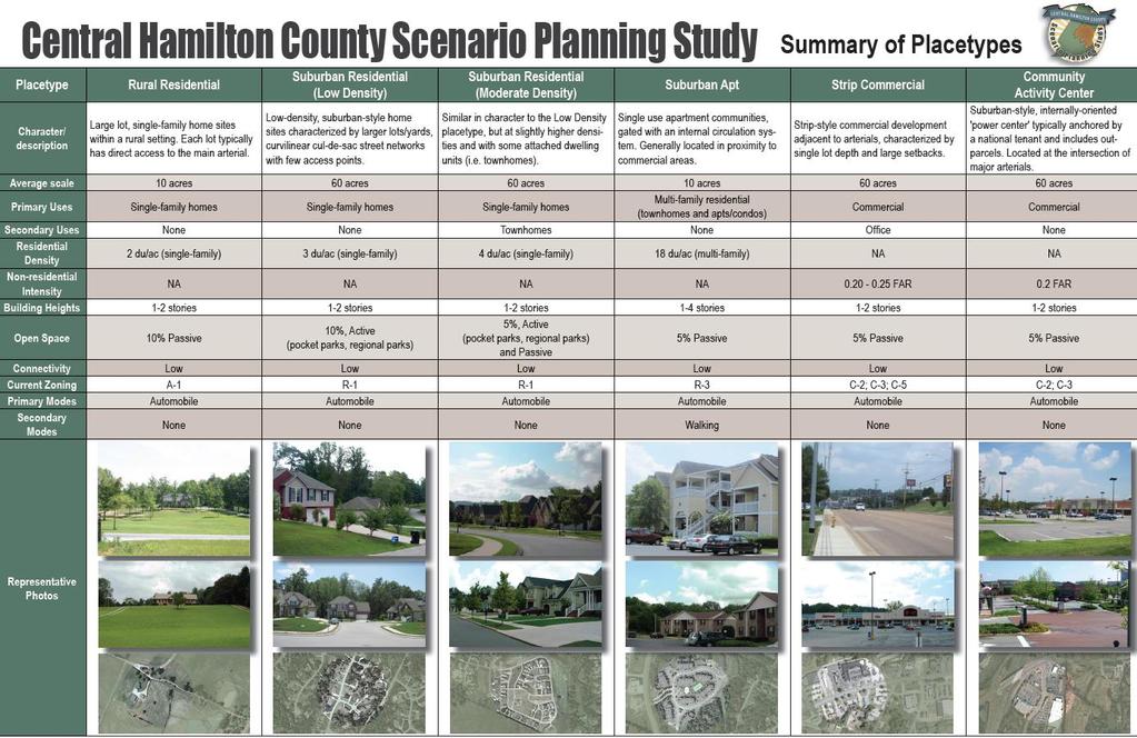
9 CHCSPS Placetypes
10 Placetypes in Practice

11 Placetypes in Practice Suburban Residential Moderate
12 Placetypes in Practice Polygon characteristics: ¼ mile (40 acres) 0% existing development 0% undevelopable 40 acres developable land Suburban Res. Mod. Placetype: MF Res. 0% SF Res. 75% Comm. 0% Off. 0% Ind. 0% Civc/Inst. 0% Park/Open 5% ROW/Inf. 20%
13 Placetypes in Practice Polygon Characteristics: MF Res. 0 acres SF Res. 30 acres Comm. 0 acres Off. 0 acres Ind. 0 acres Civc/Inst. 0 acres Park/Open 2 acres ROW/Inf. 8 acres Dwelling Units: SF res. density: SF res. LU: SF res. du s: 4 du/ac 30 acres 120 du s
14 Placetypes in Practice Polygon characteristics: ¼ mile (40 acres) 0% existing development 50% undevelopable (water) 20 acres developable land Suburban Res. Mod. Placetype: MF Res. 0% SF Res. 75% Comm. 0% Off. 0% Ind. 0% Civc/Inst. 0% Park/Open 5% ROW/Inf. 20%
15 Placetypes in Practice Polygon Characteristics: MF Res. 0 acres SF Res. 15 acres Comm. 0 acres Off. 0 acres Ind. 0 acres Civc/Inst. 0 acres Park/Open 1 acres ROW/Inf. 4 acres Dwelling Units: SF res. density: SF res. LU: SF res. du s: 4 du/ac 15 acres 60 du s

16 Example: Impervious surface Components Building area Parking area Pavement Placetype DNA Land use Density FAR Occupancy rates Avg. home sq. ft. Avg. bldg. height Spaces per home Spaces per employee Avg. parking space size % streets and driveways
17

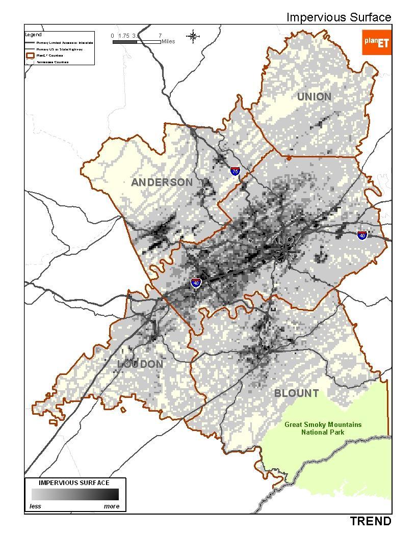
18 PRIORITY : NEW IMPERVIOUS SURFACE
19 Example: Water consumed Components Dwelling units by density (gallons consumed per DU) Placetype DNA Land use Density Commercial square footage (gallons consumed per 1KSF) Office/professional employment (gallons consumed per emp.) Etc. Land use FAR Land use FAR Employment rates (employees per 1KSF)
20 Existing water service area. Unserved water demand. Water Demand TREND
21 PRIORITY : NEW INFRASTRUCTURE Acres of new development outside of water service areas.
22 22 Place Type Attributes Land use % Density/intensity Average living area (sq. ft.) Occupancy rate (emp./s.f.) Building height Parking rate/size/height Student rates Trip generation rates Water consumption rate Wastewater generation rate Solid waste generation rate Network density Water/sewer infrastructure
23 23 Model Indicators Total residents Total dwelling units Total employment Commercial Office Industrial Proximity of people/jobs to: Work Transit Shopping Etc. Land consumption Impervious surface Water/wastewater demand Green infrastructure impacts Trips generated Total students (K-12) Police/fire demand Infrastructure cost

24 24 Redevelopment Growth is allocated to vacant land What about redevelopment? Intensification of existing places Example: Mid-town
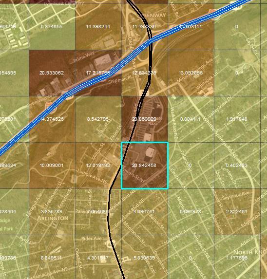
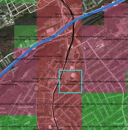


25 25 PlanET redevelopment approach 20.8 acres are redevelopable 50% redevelopment rate for Mixed Use Corridor

26 Rural/Spread out Suburban Urban/Compact Rural Residential Rural Neighborhood Rural Highway Suburban Res. Suburban Apt. Strip Commercial Industrial/ Bus. Park Transitional Neigh. Office Park Community Commercial Center Regional Commercial Center Traditional Neigh. Small Town Mixed Use Community Mixed Use Urban Neigh. Mixed Use Center/Corr. Regional Mixed Use Center Lowest (0-10%) Redevelopment rate Highest (70-80%)

27 27 Southeast Area Corridor Study Property values Non-residential Improved-to-property ratio General Urban - < 0.75 Town Center - < 1.25 TOD - < 2.00
28 28 Different approaches to redevelopment potential All non-residential land Improved-to-land value ratio Dilapidated/poor housing stock What else?
29 29 PLACE TYPES Discussion
30 30 Grid Framework Uniform polygon structure. Uniform data visualization. More precise application of placetypes. Examples: PlanET, Imagine Central Arkansas, DeSoto Discovery.


31 31 PlanET Five-county region ¼ mile (40-acre) grid
32 32 Integrated Regional Model One model run per scenario Regional systems modeling Less than 50,000 polygons (ideally closer to 30,000) Examples: PlanET; Imagine Central Arkansas
")

33 33 ¼ Mile Grid ¼ Mile (40-acre) grid Typical definition of place ¼ mile

34 34 Study Area with ¼ Mile Grid 76,000 records Too many

35 35 Refinements TAZs (80 acres or less)
 Water")
36 36 Refinements TAZs (80 acres or less) Water bodies
 Water bodies One-mile grid")
37 37 Refinements TAZs (80 acres or less) Water bodies One-mile grid Non-MPO

38 38 Refinements TAZs (80 acres or less) Water bodies One-mile grid Non-MPO Non-urban

39 39 Proposed polygon structure 34,380 total records 31,450 ¼ Mile grid 2,930 One-mile grid

40 40 Suitability Factors Measures the attractiveness of areas for accommodating new development Rates different locations in the region based on different geographical factors Assists in measuring the level of development or redevelopment of an area


41 41 How does the Model Use Suitability Factors? Uses geographical layers to determine desirable locations for development or constraints for development Weights the suitability factors based on preference

42 Various Suitability Factors to Consider Regional data coverage Focus on data that provides: Development potential Development constraints
43 Example: DeSoto Discovery Plan

44 Example: 100-Year Floodplain

45 Example: 100-Year Floodplain SCORE lower higher
46 Example: New Parks
47 Example: New Parks SCORE lower higher
48 Example: I-269 Interchanges
49 Example: I-269 Interchanges SCORE lower higher

50 Suitability Factors Natural Systems Topography Proximity to existing hospitals Farmland soils Community services Proximity to parks Proximity to proposed parks, bike paths, greenways Proximity to emergency response Proximity to major roads Proximity to secondary roads Proximity to interchanges Proximity to rail Proximity to sewer Proximity to gas Proximity to water Proximity to broadband Infrastructure/Accessibility Other Redevelopment (penalty) Residential (penalty) Proximity to employment centers Proximity to retail centers Parcel size Cemeteries (penalty)
51 Suitability: Today (2011) SCORE lower higher
52 Suitability: Proposed Conditions SCORE lower higher
53 Topography Floodplains Farmland Soils Wetlands Proximity to major roads Proximity to secondary roads Proximity interchanges Proximity to transit Proximity to rail lines Proximity to sewer Proximity to gas lines Proximity to water Proximity to broadband infrastructure Proximity to parks Proximity to schools Proximity to proposed bike routes Proximity to proposed greenways Proximity to emergency response Redevelopment Redevelopment potential Proximity to employment centers Proximity to retail centers Proximity to existing residential Regional accessibility Residential Parcel size Cemeteries Zoning compatibility Future land use policy Growth hotspot Approved development Airport landing routes 53 Peer comparison Chattanooga (CHCSPS) DeSoto Discovery PlanET (Knoxville) Imagine Central Arkansas
54 54 Current Suitability Factors Residential Suitability Factor On/Off +/- relationship Current Weight Appraised Value of Land on - 3 Availability of Water and Sewer on + 10 Distance to Airport off 0 Distance to Congested Corridors on 0 Distance to Employment Centers on + 6 Distance to Intermodal Facility off 0 Distance to Major Road on + 6 Distance to Retail Centers on + 6 Distance to Roads on + 0 Livability / Walkability on + 3 Perception of Crime on - 10 Perception of Public School System on - 10 Property Tax Rate on - 10 Within Block groups with Skilled Workforce off 0 Within Half Mile of Railroad off 0 Within Floodplain on - 10 Within High-Income Block groups off 0
55 55 Current Suitability Factors Non-Residential Suitability Factor On/Off +/- relationship Current Weight Appraised Value of Land on - 3 Availability of Water and Sewer on + 10 Distance to Airport off 0 Distance to Congested Corridors on + 10 Distance to Employment Centers on + 6 Distance to Intermodal Facility off 0 Distance to Major Road on + 10 Distance to Retail Centers off 0 Distance to Roads off 0 Livability / Walkability off 0 Perception of Crime on - 10 Perception of Public School System off 0 Property Tax Rate on - 10 Within Block groups with Skilled Workforce on + 0 Within Half Mile of Railroad off 0 Within Floodplain on - 10 Within High-Income Block groups on + 10
56 56 Current Suitability Factors Industrial Suitability Factor On/Off +/- relationship Current Weight Appraised Value of Land on - 3 Availability of Water and Sewer on + 10 Distance to Airport on + 3 Distance to Congested Corridors off 0 Distance to Employment Centers off 0 Distance to Intermodal Facility on + 10 Distance to Major Road on + 10 Distance to Retail Centers off 0 Distance to Roads off 0 Livability / Walkability off 0 Perception of Crime off 0 Perception of Public School System off 0 Property Tax Rate on - 10 Within Block groups with Skilled Workforce on + 10 Within Half Mile of Railroad on + 3 Within Floodplain on - 10 Within High-Income Block groups off 0
57 57 Suitability Factors - Survey
58 58 Suitability Factors - Survey Cost of Land Proximity to Water and Sewer Services Proximity to Airport Service Regional Accessibility to Employment and Services Proximity to Intermodal Facility Proximity to Major Road/Interchange Proximity to Retail/Commercial Centers Proximity to Schools Proximity to Livability Corridors throughout Region Avoiding Floodplain Proximity to Active Transportation Modes Proximity to Civic, Recreational and Mid-South Greenprint Assets Zoning and Land Use Compatibility Redevelopment Potential
59 PollEv.com/MemphisMPO 59
60 60 SUITABILITY FACTORS Discussion
61 61 Next Steps Refine Suitability Factors and Place Types for Model Provide the PLAC with a Draft of the LUM Study Design Update Model Existing Conditions Scenario Run Allocation (2017, 2020, 2030, 2040) Present Initial Results for Comments PLAC Meeting #3 - October 9 th ETC Work Session - October 9 th Refine Allocation Present Final Allocation Results ETC and TPB Approval (November)
 ETC and TPB Meeting (August) Model Validation Training")
62 62 Timeline PLUAC Meeting #1 (July) PLUAC Meeting #2 (September) Data Collection PLUAC Meeting #3 (October) Study Design Model Development Transportation Policy Board Approval (November) ETC and TPB Meeting (August) Model Validation Training
63 63 QUESTIONS? Thanks for your time!
Communities Plan. Parkland-Spanaway-Midland. LUAC Review of Draft Policies
 Parkland-Spanaway-Midland Communities Plan LUAC Review of Draft Policies Presented by: Tiffany O Dell, Senior Planner Planning & Public Works Tiffany.Odell@co.pierce.wa.us 253-798-6859 November 1, 2017
Project Update. Hillsborough County 2045 Population and Employment Projections and Allocations. Board of County Commissioners February 13, 2018
 Hillsborough County 2045 Population and Employment Projections and Allocations Project Update Board of County Commissioners February 13, 2018 What will Hillsborough County look like in 25 years? Working
NACCED/NACo CONFERENCE JULY 10, 2015
 NACCED/NACo CONFERENCE JULY 10, 2015 Regional Growth Framework 2 Regional Growth Framework Regional Priorities Preferred Growth Concept Tools to Support Local Governments 3 Top Priorities for the CONNECT
A BLUEPRINT FOR BROCKTON A CITY-WIDE COMPREHENSIVE PLAN
 A BLUEPRINT FOR BROCKTON A CITY-WIDE COMPREHENSIVE PLAN Public Meeting October 2016 1 Plan Summary and Discussion Public Meeting May 4 2017 City of Brockton Bill Carpenter, Mayor Department of Planning
Tri-County Transportation & Land Use Study. Steering Committee Meeting May 14, 2009
 Tri-County Transportation & Land Use Study Steering Committee Meeting May 14, 2009 Agenda Recap of Study Goals and Objectives Update on CV Land Use Model: Business as Usual (BAU) Growth Scenario Pros vs
DOMINION BOULEVARD CORRIDOR STUDY AND ECONOMIC DEVELOPMENT STRATEGIC PLAN A MODEL FOR CHESAPEAKE S FUTURE
 DOMINION BOULEVARD CORRIDOR STUDY AND ECONOMIC DEVELOPMENT STRATEGIC PLAN A MODEL FOR CHESAPEAKE S FUTURE Overview I. Draft Plan Process II. Draft Plan Overview a. Market Analysis b. Master Land Use Plan
REVIEW AND EVALUATION OF REGIONAL LAND USE
 REVIEW AND EVALUATION OF REGIONAL LAND USE AND TRANSPORTATION SCENARIOS #220831 Environmental Justice Task Force October 7, 2014 VISION 2050 Process Development of Guiding Vision for Land Use and Transportation
Joint Meeting City Council and the Plan Commission. September 1st, 2015
 Joint Meeting City Council and the Plan Commission September 1st, 2015 1 The City Plan Commission shall recommend a City Plan for the physical development of the City Article IX Section 2 of the City of
Planning Charlotte s Future. Planning Committee June 21, 2016
 Planning Charlotte s Future Planning Committee June 21, 2016 Charlotte s Vision Livable city Vibrant economy Thriving natural environment Diverse population Choices for housing, education, employment Safe
Secrest Short Cut and Monroe Expressway Small Area Plan AUGUST 29, 2018
 Secrest Short Cut and Monroe Expressway Small Area Plan AUGUST 29, 2018 Background and Process Monroe Expressway will be open by the end of 2018 Union County and Indian Trail identified a need to revisit
Gold Line Bus Rapid Transit Transit Oriented Development (BRTOD) Helmo Station Area Plan
 Helmo Station Area Plan") Appendix F Gold Line Bus Rapid Transit Transit Oriented Development (BRTOD) Helmo Station Area Plan Introduction and Purpose of the Plan The Gold Line Bus Rapid Transit facility is an eleven-mile dedicated
Appendix F Gold Line Bus Rapid Transit Transit Oriented Development (BRTOD) Helmo Station Area Plan Introduction and Purpose of the Plan The Gold Line Bus Rapid Transit facility is an eleven-mile dedicated
MORRISVILLE TRANSPORTATION PLAN TOWN COUNCIL PRESENTATION AUGUST 22, 2017
 TOWN COUNCIL PRESENTATION AUGUST 22, 2017 SCENARIO PLANNING CORRIDORS Town Hall Drive Baseline + 2 McCrimmon Parkway Baseline + 2 NC 54 Baseline + 2 7 subregion model runs determining carrying capacity
S C O P E O F W O R K A P R I L
 white flint 2 sector plan S C O P E O F W O R K A P R I L 2 0 1 2 MONTGOMERY COUNTY PLANNING DEPARTMENT M-NCPPC MontgomeryPlanning.org 1 white flint 2 sector plan Scope of Work abstract This scope of work
MAYFIELD WEST SECONDARY PLAN PHASE 2
 MAYFIELD WEST SECONDARY PLAN PHASE 2 Public Open House #3 February 25, 2010 Draft Preferred Land Use Scenario TOWN OF CALEDON PLANNING & DEVELOPMENT DEPARTMENT Open House Agenda TOWN OF CALEDON 1. Welcome
495/MetroWest Development Compact Plan Citizen Planner Training Collaborative Conference. March 17, 2012
 495/MetroWest Development Compact Plan Citizen Planner Training Collaborative Conference March 17, 2012 Project Process Local and Regional Priority Areas Growth Scenarios Transportation Investment Categories
Staff Report and Recommendation
 Community Planning and Development Planning Services 201 W. Colfax Ave., Dept. 205 Denver, CO 80202 p: 720.865.2915 f: 720.865.3052 www.denvergov.org/cpd TO: City Council Neighborhoods and Planning Committee
Atlanta BeltLine Corridor Environmental Study. Scoping Meeting August 2008
 Atlanta BeltLine Corridor Environmental Study Scoping Meeting August 2008 What Will We Be Discussing Today? Study Overview - How Did We Get Here? - What Is the Study About? - Who Is Involved? - Where Is
Definitions. Average Daily Traffic Demand (ADT): The actual number or projected number of cars that pass a point in a 24-hour period.
: The actual number or projected number of cars that pass a point in a 24-hour period.") Definitions Access Management: A combination of physical techniques and transportation policies used to control the flow of traffic between roads and the surrounding lands. Alternative City Form Scenarios:
Definitions Access Management: A combination of physical techniques and transportation policies used to control the flow of traffic between roads and the surrounding lands. Alternative City Form Scenarios:
TOWN OF NEW CASTLE - Master Plan Update
 Our Presentation Today (1) Recap the Master Planning Process To Date (2) Present the Outline of the Master Planning Work Plan (3) Present the Calendar for the Master Plan (4) Outline the scope of a Downtown
Public Open House #1
 Public Open House #1 TONIGHT S AGENDA Welcome Project Overview The Big Picture The Station Area The Analysis Thoughts about Future Change Breakout Group Discussions Summation / Next Steps Project Overview
Silver Line CPAM UPDATE. Transportation and Land Use Committee October 14, 2016
 Silver Line CPAM UPDATE Transportation and Land Use Committee October 14, 2016 Purpose Recap Project History and Map Changes Provide Overview of CPAM Components Discuss Transportation Impacts Discuss Fiscal
PLAN ELEMENTS WORKSHOP. April 5, 2016
 PLAN ELEMENTS WORKSHOP April 5, 2016 needs more housing. But there is no one-size fits-all solution. Every neighborhood has its own character. In some places, density is not only appropriate it is badly
Today s Topics. 1. Master Plan Conformance discussion. 2. Planned Unit Development (PUD) Guide Review discussion
 Guide Review discussion") Today s Topics 1. Master Plan Conformance discussion 2. Planned Unit Development (PUD) Guide Review discussion 3. Market Study & Fiscal Impacts discussion 2 2013 Mid Valley Area Community Plan Project
Today s Topics 1. Master Plan Conformance discussion 2. Planned Unit Development (PUD) Guide Review discussion 3. Market Study & Fiscal Impacts discussion 2 2013 Mid Valley Area Community Plan Project
Prosperity Hucks Area Plan. Transportation and Planning Committee May 11, 2015
 Prosperity Hucks Area Plan Transportation and Planning Committee May 11, 2015 Presentation Outline 1. Background and Location 2. Community Dialog Process 3. Activity Center Recommendations 4. Wedge Recommendations
Elderberry, Pioneer, Junction
 February 15, 2018 Pioneer Road Pioneer Mineral Point Road Elderberry Pleasant View Road Junction Junction Road Agenda Recap of Background Information, Open House #1 Draft Neighborhood Development Plan
Chapter 1.0 Introduction
 Chapter 1.0 Introduction 1.1 Background The North Metro commuter rail line is part of the RTD FasTracks regional transit system expansion program to build more than 100 miles of rail transit throughout
MAYFIELD WEST SECONDARY PLAN PHASE 2
 MAYFIELD WEST SECONDARY PLAN PHASE 2 Council Information Workshop February 16, 2010 Draft Preferred Land Use Plan TOWN OF CALEDON PLANNING & DEVELOPMENT DEPARTMENT Workshop Agenda TOWN OF CALEDON 1. Welcome
2.7 ac park. TOTAL 5,403 DU 1,297,900 sf 1,105,450 sf 3.87 ac 5,563 DU 1,121,200 sf 1,105,450 sf 3.87 ac
 PLAN AMENDMENT 2013-I-B1: SEVEN CORNERS SPECIAL STUDY Summary of Pre-staffing Comments Planner: Bernard Suchicital bsuchi@fairfaxcounty.gov (703) 324-1254 Background On October 29, 2013, the Board of Supervisors
FUTURE LAND USE PLAN 7
 FUTURE LAND USE PLAN 7 The recommendations of each of the preceding chapters can be combined to present an overall Future Land Use Plan for Wilton. The Future Land Use Plan, presented on the following
AWH REPORT OF THE PLANNING AND DEVELOPMENT DEPARTMENT FOR APPLICATION FOR REZONING ORDINANCE TO PLANNED UNIT DEVELOPMENT
 AWH REPORT OF THE PLANNING AND DEVELOPMENT DEPARTMENT FOR APPLICATION FOR REZONING ORDINANCE TO PLANNED UNIT DEVELOPMENT MAY 8, 2014 The Planning and Development Department hereby forwards to the Planning
COLVER ROAD INDUSTRIAL CONCEPT PLAN
 COLVER ROAD INDUSTRIAL CONCEPT PLAN A CONCEPTUAL LAND USE AND TRANSPORTATION PLAN FOR TA-4 AN URBAN RESERVE AREA OF THE CITY TALENT City of Talent Adopted by City Council Resolution No., June, 2015 PART
Proposed Comprehensive Plan Strategies DRAFT for discussion June 28, 2017
 Proposed Comprehensive Plan Strategies DRAFT for discussion June 28, 2017 Land Use Rural Areas Refine the Farm and Forest area (FF) Update FF boundaries to account for existing lots less than five acres
IMPLEMENTING SOMERSET COUNTY S INVESTMENT FRAMEWORK
 IMPLEMENTING SOMERSET COUNTY S INVESTMENT FRAMEWORK SMART CONSERVATION THROUGH SMART GROWTH NJ LAND CONSERVATION RALLY March 22, 2014 Laurette Kratina, PP, AICP, Supervising Planner Somerset County Planning
3 Vision and Goals. Vision and Goals. Blueprint for Bloomsburg. Vision. Town of Bloomsburg Comprehensive Plan,
 Vision and Goals 3 Vision and Goals Citizens of the Town of Bloomsburg clearly value their natural and cultural heritage, the walkable, mixed use pattern of downtown, the access to education, and the community
2040 LUP is a part of the Comprehensive Plan and carries the same legal authority. Economic Challenges
 1.1. Guiding Anchorage s Growth Where will new residents settle over the next two decades? Where will people work, shop, and play? Will there be enough room to grow? How will Anchorage look? Will growth
open public hearing and allow public comment request to continue LPA public hearing to January 16, 2014 at 10:30 am
 TODAY S AGENDA Work Session LPA Transmittal Public Hearing open public hearing and allow public comment request to continue LPA public hearing to January 16, 2014 at 10:30 am staff will issue a recommendation
Subregion 4 Central Avenue-Metro Blue Line Corridor Transit-Oriented Development (TOD) Implementation Project. Community Meeting April 27, 2011
 Implementation Project. Community Meeting April 27, 2011") Subregion 4 Central Avenue-Metro Blue Line Corridor Transit-Oriented Development (TOD) Implementation Project Community Meeting April 27, 2011 Overview Introduction to Subregion 4 TOD Implementation Program
Subregion 4 Central Avenue-Metro Blue Line Corridor Transit-Oriented Development (TOD) Implementation Project Community Meeting April 27, 2011 Overview Introduction to Subregion 4 TOD Implementation Program
Newton Town Centre. Land Use, Urban Design & Transportation Plan
 Newton Town Centre Land Use, Urban Design & Transportation Plan Public Workshop - June 2-4, 2009 6:15 6:30 Sign-in & conversations Tonight s Agenda 6:30 6:55 Project introduction and summary of previous
LAND USE DESIGNATIONS AND ZONING CLASSIFICATIONS
 LAND USE DESIGNATIONS AND ZONING CLASSIFICATIONS One of the most significant issues addressed within the community plan process is land use. How land is utilized within a community directly affects the
BeltLine Corridor Environmental Study
 BeltLine Corridor Environmental Study Joint TAC and SAC Meeting December 8, 2008 What We Will Discuss Today Outreach and Agency Coordination Scoping Results Existing Conditions Historical and Archeological
PART 1: PROJECT SUMMARY. The application is Attachment A. The site plan is Attachment B.
 Belleterre Subdivision Sketch Plan Town Board 8.7.17 Belleterre Subdivision Sketch Plan PART 1: PROJECT SUMMARY Applicant: Bowman Development Project Size: +/- 20.85 acres Parcel Number: 01115104 and 01115121
12 AMENDMENT NO. 149, TOWN OF MARKHAM HIGHWAY 404 NORTH SECONDARY PLAN
 12 AMENDMENT NO. 149, TOWN OF MARKHAM HIGHWAY 404 NORTH SECONDARY PLAN The Planning and Economic Development Committee recommends the adoption of the recommendation contained in the following report August
New Auburn Village Center Study Auburn, Maine
 Auburn, Maine Option Review Summary Prepared for: Androscoggin Transportation Resource Center and City of Auburn Prepared by: T.Y. Lin International MRLD October 10, 2013 1. Introduction This memo summarizes
Natomas Vision Plan and PLNP
 Natomas Vision Plan 20030171 and PLNP2014-00172 Department of Community Development Planning and Environmental Review Leighann Moffitt Sub-Agenda 1. Staff Presentation Leighann Moffitt, County Planning
Chapter #3 LAND USE AND SCENARIO PLANNING
 Chapter #3 LAND USE AND TABLE OF CONTENTS 3.0 Land Use and Scenario Planning...3-1 3.1 Introduction IMAGINE 2040...3-1 3.2 Background...3-3 3.2.1 4D Analysis...3-3 3.3 Imagine 2040 Scenario Planning...3-7
C l e a r L a k e G a l v e s t o n B a y CLEAR LAKE SHORES ")2094 KEMAH. Columbia Memorial Pkwy. Smith Ln. Louisiana Ave. Austin St.
2094 KEMAH. Columbia Memorial Pkwy. Smith Ln. Louisiana Ave. Austin St.") Vacant Land 4 - Growth Analysis Redevelopment Areas Planned Unit Developments The focus of this element is two fold - first, to identify and assess current conditions and ey issues in League City that
Vacant Land 4 - Growth Analysis Redevelopment Areas Planned Unit Developments The focus of this element is two fold - first, to identify and assess current conditions and ey issues in League City that
12/9/2013. HOLLYWOOD/PINES CORRIDOR PROJECT AMPO 2013 Annual Conference October 24, Our Perspective. Broward.
 HOLLYWOOD/PINES CORRIDOR PROJECT AMPO 2013 Annual Conference October 24, 2013 Our Perspective Broward Fort Lauderdale 1 Broward Metropolitan Planning Organization Fort Lauderdale Fort Lauderdale Skyline
Warren County/Bowling Green Focus 2030 Comprehensive Plan VOLUME 1 INDEX
 Appendix 5: Index VOLUME 1 INDEX A Aesthetics ES-6, FLU-15, FLU-17, FLU-24, NCR-7 Agricultural Base FLU-18, FLU-20 Agricultural Centers, Rural FLU-11 Agricultural District NCR-17-NCR-18 Agricultural Economy
City of Long Beach. creating vibrant and exciting places
 City of Long Beach creating vibrant and exciting places Land Use Element Urban Design Element Overview of the two draft General Plan elements Discuss areas of change Economic goals of the plans Case study
Danvers High Street I-1 District Study
 Danvers High Street I-1 District Study Presentation of Final Recommendations Planning Board Presentation June 26 th, 2018 1 Introductions Metropolitan Area Planning Council Sam Cleaves AICP, Principal
Atlanta BeltLine Subarea 3 Master Plan Update
 Atlanta BeltLine Subarea 3 Master Plan Update April 14, 2018 Workshop Meeting 1 22 miles, connecting 45 neighborhoods 22 MILES of transit 46 MILES of streetscapes and complete streets 33 MILES of urban
Access to the University of North Carolina at Chapel Hill, UNC Hospitals, and Chapel Hill Transit.
 M 1/ 4 1/ 2 E IL M E IL Station Family: County: City: UNC Hospitals WHY THIS STATION? University Village Orange Chapel Hill Access to the University of North Carolina at Chapel Hill, UNC Hospitals, and
CHUGIAK-EAGLE RIVER SITE-SPECIFIC LAND USE PLAN
 CHUGIAK-EAGLE RIVER SITE-SPECIFIC LAND USE PLAN JUNE 2010 Final Prepared for The Heritage Land Bank, Municipality of Anchorage by Agnew: :Beck Consulting www.agnewbeck.com 907.222.5424 Chugiak-Eagle River
DESIGN WORKSHOP. November 17, 2015
 DESIGN WORKSHOP November 17, 2015 needs more housing. But there is no one-size fits-all solution. Every neighborhood has its own character. In some places, density is not only appropriate it is badly -
This chapter describes the purpose of the Plan, introduces how the Plan is organized and provides contextual background for the Plan.
 Chapter 1: INTRODUCTION Purpose of a Comprehensive Plan The 2040 Comprehensive Plan establishes Medina s vision as a community and sets goals and objectives which guide future decisions and policies. The
Tyvola & Archdale Transit Station Area Plan. May 15, 2008
 Tyvola & Archdale Transit Station Area Plan First Public Meeting May 15, 2008 Presentation Outline 1. Purpose and Process 2. Station Area Overview 3. Plan Recommendations Vision Land Use Transportation
Planning Commission Special Workshop. October 25, 2018
 Planning Commission Special Workshop October 25, 2018 Composition of Committee Steven Neeves, Chair Marvin Heyd, Vice-Chair Joe Burch Pam Creech Ruth Anne Ellis Rick Elliott Christy Everett Chris Hennigan
BeltLine Corridor Environmental Study
 BeltLine Corridor Environmental Study Citywide Conversation on Transit and Trails April 2, 2009 Agenda & Introductions Introductions Environmental Study Process Overview of the BeltLine Project BeltLine
Colchester Growth Management Strategy. Open House Meeting October 1, 2015
 Colchester Growth Management Strategy Open House Meeting October 1, 2015 6:00 View panels and meet the consultant team 6:30 Presentation and Q&A 7:30 Informal discussion and fill out comment sheets The
DRAFT Land Use Chapter
 Stevens Creek Urban Village DRAFT 1 18 17 Land Use Chapter INTRODUCTION This Land Use Chapter describes how the Stevens Creek Urban Village will accommodate the growth that is planned for it in the Envision
Environmental: Urban land..51 acre wet (.30%); 1.01 acres/.59% within a 100 year floodplain; no other environmental indicators limit development.
; 1.01 acres/.59% within a 100 year floodplain; no other environmental indicators limit development.") A N DOV ER Downtown: Designated a State PDA Land Use: Downtown Andover (171.61 acres) is the Town s traditional central business district. It consists of offices, shops, restaurants, civic and institutional
A N DOV ER Downtown: Designated a State PDA Land Use: Downtown Andover (171.61 acres) is the Town s traditional central business district. It consists of offices, shops, restaurants, civic and institutional
Presentation Outline. Southwest Area Plan. Slide 1. Slide 2. Presentation to the Committee of the Whole. September 20, 2011
 Slide 1 Southwest Area Plan Presentation to the Committee of the Whole September 20, 2011 Slide 2 Presentation Outline City-Wide Growth Planning Link Official Plan Policies Current Situation and Projections
DELIVERING ON THE TRANSIT PROMISE
 DELIVERING ON THE TRANSIT PROMISE Dena Belzer October 6, 2015 Presentation Overview 1. Puget Sound As a Transit Region: Putting SeaTac in Context 2. Starting at the Beginning: How Does TOD Work? 3. Strategies
INDEPENDENCE BOULEVARD AREA PLAN
 INDEPENDENCE BOULEVARD AREA PLAN Public Meeting October 28, 2008 Tonight s Agenda Introduction 4:00 4:05 Tom Warshauer Presentation 4:05 5:00 Blake Drury Group Exercises 5:00 5:50 All Wrap Up & Next Steps
Integrated Urban Development. April Reflections from the NZPI Study Tour of Portland, Seattle and Vancouver
 Integrated Urban Development April 2009 Reflections from the NZPI Study Tour of Portland, Seattle and Vancouver Integrated Urban Development Urban Growth Management Transportation Transit Orientated Mixed
Getting and Giving the Most
 Getting and Giving the Most It s OUR meeting participate enthusiastically Focus on the future Terminology expertise is secondary There is such a thing as a bad idea! Respect (for each other and the process)
Developer s Program. The Station at East 54
 Developer s Program The Station at East 54 Existing Conditions The Station at East 54 is proposed for a 1.12 acre site at the northeast corner of Hamilton Road and Prestwick Road, tucked between the East
VILLAGE OF CLEMMONS PLANNING BOARD DRAFT STAFF REPORT
 VILLAGE OF CLEMMONS PLANNING BOARD DRAFT STAFF REPORT PETITION INFORMATION Docket # C-226 Staff Megan Ledbetter Petitioner(s) JBJH Properties, LLC Owner(s) JBJH Properties, LLC Subject Property 5892-49-1766
Floyds Fork Area Study Project Overview, Suitability Analysis, & Form Districts July 29, title
 Floyds Fork Area Study Project Overview, Suitability Analysis, & Form Districts July 29, 2008 Agenda Floyds Fork Area Study Project overview and purpose Process and schedule Ongoing initiatives Floyds
Create Policy Options Draft Plan Plan Approval. Public Consultation Events. Phase 2
 Background Grandview-Woodland Community Plan In the spring of 2012, the City of Vancouver embarked on a comprehensive community planning program in the Grandview-Woodland neighbourhood. The process has
9 CITY OF VAUGHAN OFFICIAL PLAN AMENDMENT NO BOCA EAST INVESTMENTS LIMITED
 9 CITY OF VAUGHAN OFFICIAL PLAN AMENDMENT NO. 631 - BOCA EAST INVESTMENTS LIMITED The Planning and Economic Development Committee recommends the adoption of the recommendations contained in the following
Table IX-1 LAND USES IN WASHINGTON COUNTY: 2006
 #128550 v1 - WASH CO CP TBL I-1 2006 LU NMA/RLR 12/21/07 Table I-1 LAND USES IN WASHINGTON COUNTY: 2006 Note: This table, and the accompanying map, is more general than the land use inventory conducted
Citizen Comment Staff Response Staff Recommended Revision Planning Committee
 Citizen Comment Staff Response Staff Recommended Revision Planning Committee Area No. 1: Owner desires retail land uses. Area No. 1a: Owner of two small parcels adjacent to Area No. 1 desires retail land
2010 Plan of Conservation and Development
 2010 Plan of Conservation and Development Wilton Planning and Zoning Commission Adopted November 2, 2009 Effective January 1, 2010 WILTON 2010 PLAN OF CONSERVATION & DEVELOPMENT PARTICIPANTS Planning &
Section 4 BUILDING THE MASTER PLAN
 The Master Plan 33 Section 4 BUILDING THE MASTER PLAN Figure 4:1. A collaborative effort characterized the two design workshops sponsored by DISC to create hypothetical Master Plans for the Towers Property
Official Plan Review
 Official Plan Review Summary Report - The Built Environment August 2014 Part 1: Introduction Planning for a healthy, prosperous and sustainable community is an important goal for our municipality. From
Atlanta BeltLine. Subareas 9 & 10. Master Plan Updates. March 26, Washington Park Jamboree 1
 Atlanta BeltLine Subareas 9 & 10 Master Plan Updates March 26, 2018 Washington Park Jamboree 1 22 miles, connecting 45 neighborhoods 22 MILES of transit 46 MILES of streetscapes and complete streets 33
RE-Imagining the Downtown Colorado Springs Master Plan
 RE-Imagining the Downtown Colorado Springs Master Plan 2016 APA Colorado State Conference October 25, 2016 Overview 8:00 Welcome, Introductions, and Overview 8:15 Downtown s Planning History 8:30 A Market
LAND USE ELEMENT. Purpose. General Goals & Policies
 LAND USE ELEMENT Purpose This Land Use Element contains the goals and policies necessary to support the City s responsibility for managing land resources and guiding development through implementing regulations,
Municipal Development Plan Update Urban Service Area and Hamlets
 ENCLOSURE 1 Municipal Development Plan Update Urban Service Area and Hamlets Priorities Committee January 24, 2017 MUNICIPAL DEVELOPMENT PLAN UPDATE SHAPING OUR FUTURE MDP Update - Agenda MDP Update Public
TREASURE COAST REGIONAL PLANNING COUNCIL M E M O R A N D U M. To: Council Members AGENDA ITEM 5H
 TREASURE COAST REGIONAL PLANNING COUNCIL M E M O R A N D U M To: Council Members AGENDA ITEM 5H From: Date: Subject: Staff October 17, 2008 Council Meeting Local Government Comprehensive Plan Review Draft
Coronation Park Neighbourhood Plan. Open House #2 15 September 2016
 Coronation Park Neighbourhood Plan Open House #2 15 September 2016 Outline What is a Neighbourhood Plan? Project Status Update Policy Context Refresher Coronation Park Yesterday & Today What We Heard -
Union City General Plan Update. City Council Meeting Item VII.a July 28, 2015 Land Use Concepts and Evaluation Criteria
 Union City General Plan Update City Council Meeting Item VII.a July 28, 2015 Land Use Concepts and Evaluation Criteria Meeting Outline The Update Process Overview and Purpose Draft Focus Area Concepts
Laberge Group. Town of Coeymans. Draft Comprehensive Plan. Overview of Planning Process
 Draft : Presentation of Goals & Strategies Laberge Group Benjamin H. Syden, A.I.C.P., E.D.P Director in Charge Nicole Allen, A.I.C.P. Senior Planner Anjali Malhotra Planner Presentation Outline Introductions
REQUEST Current Zoning: O-15(CD) (office) Proposed Zoning: TOD-M(CD) (transit oriented development mixed-use, conditional)
 (office) Proposed Zoning: TOD-M(CD) (transit oriented development mixed-use, conditional)") Rezoning Petition 2016-117 Zoning Committee Recommendation January 4, 2017 REQUEST Current Zoning: O-15(CD) (office) Proposed Zoning: TOD-M(CD) (transit oriented development mixed-use, conditional) LOCATION
Rezoning Petition 2016-117 Zoning Committee Recommendation January 4, 2017 REQUEST Current Zoning: O-15(CD) (office) Proposed Zoning: TOD-M(CD) (transit oriented development mixed-use, conditional) LOCATION
ATTACHMENT A 09/12/2011. Attachment A - 1. A. Preliminary Future Transit Station Sub-area
 ATTACHMENT A A. Preliminary Future Transit Station Sub-area The Centers, Corridors and Wedges Growth Framework describes Transit Station Areas, which are sub-areas within Growth Corridors, as areas surrounding
TRANSPORTATION AND LAND USE
 CHAPTER 10 TRANSPORTATION AND LAND USE Transportation and land use are intimately linked. The expansion of a highway typically spurs housing, employment growth and land development in the communities that
Westbound: A One-day Exploration of Growth
 Westbound: A One-day Exploration of Growth Frog Pond Area 2018 UGB Expansion Proposal June 13, 2018 Growing Out: UGB Asks Four cities submitted proposals to expand greater Portland s urban footprint by
Prepared for the Citizens of Forsyth County by the City-County Planning Board
 Prepared for the Citizens of Forsyth County by the City-County Planning Board Bryce A. Stuart Municipal Building 100 East First Street, Winston-Salem, NC 27101 336.727.8000 www.cityofws.org/planning www.legacy2030.com
DRAFT PLAN PRESENTATION
 DRAFT PLAN PRESENTATION 1.23.2018 AGENDA Process Project Schedule Results from Visioning Workshop Draft Plan Highlights Concept Plans Feedback Next Steps PROJECT SCHEDULE KICK-OFF WORKSHOP August 29 th
Future Land Use and Transportation
 Planning & Zoning Board Workshop Comprehensive Plan for Village of Estero Future Land Use and Transportation April 6, 2017 January Kick-off Meeting Public Input What do you like about Estero? Location
CITY OF PUYALLUP. Background. Development Services
 CITY OF PUYALLUP Development Services 333 South Meridian Puyallup WA 98371 To: City Council From: Katie Baker, AICP, Planning Division Re: South Hill Neighborhood Plan Adoption Date: (Meeting date: February
Transportation. Strategies for Action
 Transportation A major priority for the Overlake Neighborhood is to develop a multimodal transportation system. To achieve this system, a balance has to be found among travel, circulation and access needs;
Implementation Guide Comprehensive Plan City of Allen
 Implementation Guide 2030 Comprehensive Plan City of Allen DRAFT 2015 Implementation Guide Allen 2030 Comprehensive Plan INTRODUCTION The Comprehensive Plan serves as a guide for the growth and development
Public Meeting March 10 th 2011
 Public Meeting March 10 th 2011 Agenda 6:00-6:15 6:15-7:00 7:00-8:00 8:00-8:30 8:30-9:00 9:00 Welcome and Introductions Presentation» Project Overview» Recap Existing Conditions / Issues & Opportunities»
5 Land Use Element49
 5 Land Use Element 49 City of Forney - Comprehensive Plan Land Use Introduction Forney s Comprehensive Plan is a guide for physical and economic development in the City of Forney over the next 20-years.
A. WHAT IS A GENERAL PLAN?
 I. Introduction A. WHAT IS A GENERAL PLAN? A general plan is the planning guideline for the future of a city. It contains goals and policies which regulate urban development, the protection of the natural
Tyvola & Archdale Transit Station Area Plan. June 5, 2008
 Tyvola & Archdale Transit Station Area Plan Second Public Meeting June 5, 2008 Presentation Outline 1. Purpose and Process 2. Station Area Overview 3. Plan Recommendations 4. Comments Received and Proposed
Hillsborough County MPO Transit Study. Citizens Team Workshop Wednesday, February 28 th, 2006 Hillsborough Community College - Brandon
 Hillsborough County MPO Transit Study Citizens Team Workshop Wednesday, February 28 th, 2006 Hillsborough Community College - Brandon What is the MPO Transit Study? An effort to look at the full range
Improve Neighborhood Design and Reduce Non Point Source Water Pollution
 HOW TO Planning Guide Improve Neighborhood Design and Reduce Non Point Source Water Pollution This document was funded by a grant from the New Hampshire Coastal Program with funding from the National Oceanic