EACCS Goal: provide guidelines for mitigation practices and overall conservation in east Alameda County
|
|
|
- Lindsey Miller
- 5 years ago
- Views:
Transcription
1 EAST ALAMEDA COUNTY CONSERVATION STRATEGY: A BLUEPRINT FOR ACTION Community Meeting June 11, 2009 Agenda Welcome and Introductions Project Update o Introduction o Progress to Date o Next Steps Perspectives from Participants 1
2 Key Points EACCS Goal: provide guidelines for mitigation practices and overall conservation in east Alameda County Key Points Biologically og based strategy Voluntary program Would not result in permits but would support the permitting process for local projects Will not create new mandates on private land in Alameda County 2
3 Steering Committee Alameda County Alameda County Congestion Management Agency Alameda County Resource Conservation District Alameda County Waste Management Authority California Department of Fish and Game City of Dublin City of Livermore City of Pleasanton East Bay Regional Park District Natural Resources Conservation Service San Francisco Bay Regional Water Quality Control Board U.S. Fish and Wildlife Service Zone 7 Water Agency User s Advisory Group Alameda Creek Alliance Alameda LAFCO Audubon Society Ohlone Chapter California Coastal Conservancy California Native Plant Society Fletcher Conservation Properties Friends of Livermore Friends of Springtown Preserve Friends of the Vineyards Greenbelt Alliance Hacienda Business Park Home Builders Association of Northern California Individual Rural Landowners Lawrence Livermore Laboratories Livermore Area Recreation and Park District Robert Harris & Associates Save Mount Diablo San Francisco Public Utilities Commission Sierra Club The Nature Conservancy Tri-Valley Conservancy 3
4 A Regional Conservation Strategy EACCS will: o Document important biological resources in eastern Alameda County o Set priorities for mitigation and conservation o Include clear standards for avoidance, minimization, and monitoring o Set mitigation ratios where appropriate Phase 1 Phase 2 Phase 3 UAG 4
5 EACCS Conservation Process Focal Species Needs -Occurrence data -Habitat Models -Recovery Needs Land Cover Data -Rarity or Irreplaceability -Level of Current Protection Open Space Data -Level of Protection -Basis for Gap Analysis Habitat Goals -Upland Habitat Goals Project -Existing Land Use Plans -Adjacent Conservation Plans Future Threats -Expected Land Cover Changes -Lack of Management EACCS Conservation Strategy Landscape Linkages -Within Study Area -To Contra Costa, San Joaquin, Santa Clara Co. Wildlife Corridors -Across I-580 -Across I-680 -Aquatic and Upland Habitat Conservation Guidance -Grant Funded Conservation -Parks and Land Conservancies -Voluntary Easements Implementation Project-Level Mitigation Guidance -Mitigation Ratios -Mitigation Opportunities -Mitigation Toolbox A Focal Species Is likely rare and often protected Could serve as an indicator for the health h of the habitat where it lives Could serve as an indicator for the population health of other native species Could be used to answer regional conservation questions (i.e., habitat connectivity) Extends conservation benefits to other native species and natural communities 5
6 Species Selection Process Selection Criteria Range is the species in the study area? Status is the species listed or expected to be listed by state or feds? Threats what are they and can they be mitigated? Data is the species well understood? Other Criteria Are there conservation opportunities? i Are there accepted mitigation practices for the species? Is the species included in other conservation plans in the region? Focal Species List 2 invertebrates 2 amphibians 1 reptile 3 birds 2 mammals 6 plants 6
 Callippe silverspot butterfly (FE) Longhorn")
 California red-legged")

7 Invertebrates Vernal pool fairy shrimp (FT) Longhorn fairy shrimp (FE) Callippe silverspot butterfly (FE) Longhorn fairy shrimp Vernal pool fairy shrimp Amphibians and Reptiles Alameda whipsnake (ST, FT) California red-legged frog (CSC, FT) California tiger salamander (SC, FT) Alameda whipsnake California red-legged frog California tiger salamander 7


")
 American")
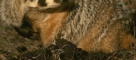
8 Birds Golden eagle (BGPA, CSC, Fully Protected, MBTA) Western burrowing owl (CSC, MBTA) Tricolored blackbird (CSC, MBTA) Tricolored blackbird Golden eagle Western burrowing owl Mammals American badger (CSC) San Joaquin kit fox (FE, ST) American badger San Joaquin kit fox 8

 Palmate-bracted")
 Livermore Valley tarplant")


9 Plants San Joaquin spearscale (CNPS 1B.2) Big tarplant (CNPS 1B.1) Congdon s tarplant (CNPS 1B.1) Palmate-bracted bird s beak (SE, FE, CNPS 1B.1) Livermore Valley tarplant (CNPS 1B.1) Recurved larkspur (CNPS 1B.2) Palmate-bracted bird s beak Big tarplant San Joaquin spearscale Recurved larkspur Congdon s tarplant *May add a few more plant species. 9
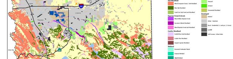
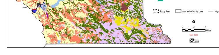
10 EACCS Conservation Process Focal Species Needs -Occurrence data -Habitat Models -Recovery Needs Land Cover Data -Rarity or Irreplaceability -Level of Current Protection Open Space Data -Level of Protection -Basis for Gap Analysis Habitat Goals -Upland Habitat Goals Project -Existing Land Use Plans -Adjacent Conservation Plans Future Threats -Expected Land Cover Changes -Lack of Management EACCS Conservation Strategy Landscape Linkages -Within Study Area -To Contra Costa, San Joaquin, Santa Clara Co. Wildlife Corridors -Across I-580 -Across I-680 -Aquatic and Upland Habitat Conservation Guidance -Grant Funded Conservation -Parks and Land Conservancies -Voluntary Easements Implementation Project-Level Mitigation Guidance -Mitigation Ratios -Mitigation Opportunities -Mitigation Toolbox Land Cover Map: Methods Developed land cover classification based on standard references (Manual of California Vegetation) and needs of EACCS and focal species Mapped ~32 land cover types including: o o o o o o o o o o Annual grassland Chaparral and scrub Oak woodland Mixed evergreen forest Coulter pine forest Riparian woodland Ponds & Quarry ponds Wetlands Cultivated agriculture Developed 10


11 Land Cover Mapping Process Heads-up digitizing (on screen) Standardized di d and consistent t approach Photo signature recognition training Photo signature consistency testing Standard minimum mapping unit (MMU) o 10-acre for most types o 0.25-acre for riparian, wetlands, ponds, rock outcrops 11
12 12


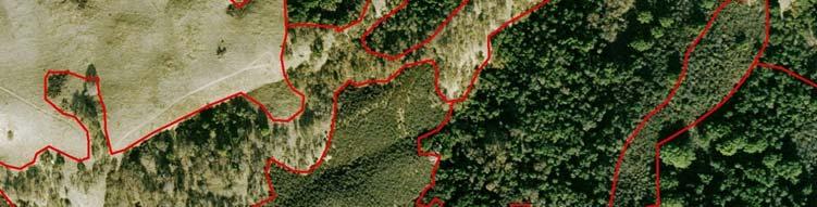
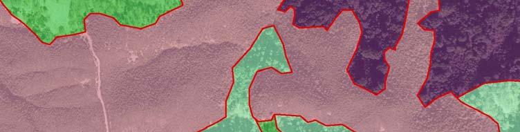
13 Insert aerial map of study area Insert new land cover map 13


14 Key Points 5100 individual polygons Dominant land cover types include: Annual grassland 116,827 ac 43% Foothill pine/oak Woodland 22,694 ac 8% Least common land cover types: Coulter pine woodland d 74 ac % Perennial freshwater marsh 62 ac % 14


15 Land Cover Acreages Land Cover* Number of Total Acres in Percent of Study Polygons Digitized Study Area Area Annual Grassland Blue Oak Woodland Mixed Serpentine Chaparral Sycamore Alluvial Woodland ,827 43% ,476 10% 54 3,788 1% % *All land cover types are shown in Table
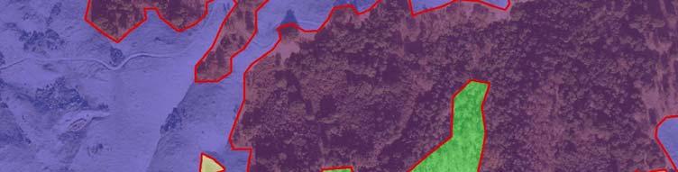
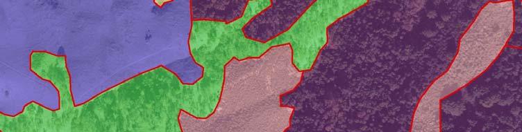
16 EACCS Conservation Process Focal Species Needs -Occurrence data -Habitat Models -Recovery Needs Land Cover Data -Rarity or Irreplaceability -Level of Current Protection Open Space Data -Level of Protection -Basis for Gap Analysis Habitat Goals -Upland Habitat Goals Project -Existing Land Use Plans -Adjacent Conservation Plans Future Threats -Expected Land Cover Changes -Lack of Management EACCS Conservation Strategy Landscape Linkages -Within Study Area -To Contra Costa, San Joaquin, Santa Clara Co. Wildlife Corridors -Across I-580 -Across I-680 -Aquatic and Upland Habitat Conservation Guidance -Grant Funded Conservation -Parks and Land Conservancies -Voluntary Easements Implementation Project-Level Mitigation Guidance -Mitigation Ratios -Mitigation Opportunities -Mitigation Toolbox Open Space Map Map all open space areas in study area Open Space = all publicly owned parklands or private lands with easements or deed restrictions Open space lands can range from EBRPD parkland to private mitigation banks to city parks and golf courses. Basically these lands are undeveloped and will remain so for the foreseeable future 16

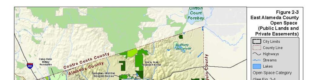
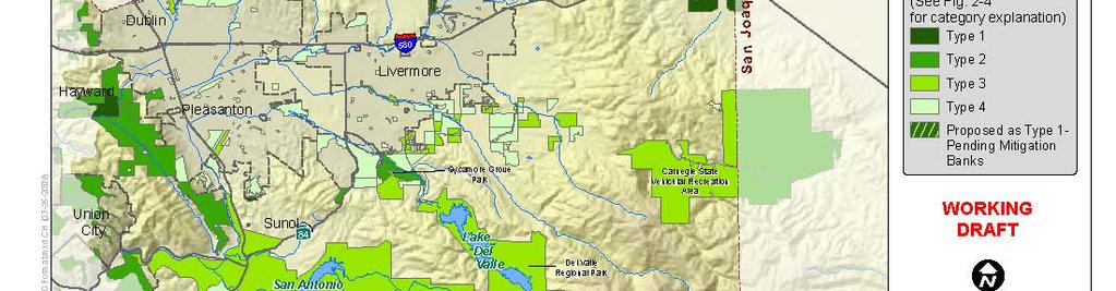
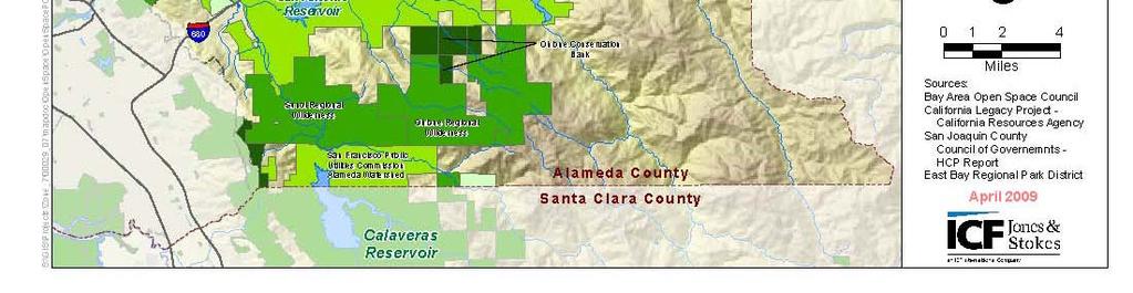
17 Open Space Map 17
18 Open Space Total study area = 271,485 acres Open Space currently under some level of protection = 91,301* acres (34% of study area) o Type 1 = 4,463* ac (2%) o Type 2 = 46,248 ac (17%) o Type 3 = 27,663 ac (10%) o Type 4 = 12,927 ac (5%) *1,238 acres are currently proposed Type 1 Current Level of Protection Land Cover Total Acres in Type 1 Type 2 Type 3 Type 4 Study Area (Acres/%) (Acres/%) (Acres/%) (Acres/%) Annual Grassland 116,827 2,810/2% 9,087/8% 12,950/11% 3,384/3% Blue Oak Woodland 26, /1% 4,009/15% 3,225/12% 936/4% Mixed Serpentine 3,788 0/0% 48/1% 24/<1% 0/0% Chaparral Sycamore Alluvial Woodland 597 0/0% 299/50% 239/40% 26/4% 18
19 Developing the Conservation Strategy EACCS Conservation Process Focal Species Needs -Occurrence data -Habitat Models -Recovery Needs Land Cover Data -Rarity or Irreplaceability -Level of Current Protection Open Space Data -Level of Protection -Basis for Gap Analysis Habitat Goals -Upland Habitat Goals Project -Existing Land Use Plans -Adjacent Conservation Plans Future Threats -Expected Land Cover Changes -Lack of Management EACCS Conservation Strategy Landscape Linkages -Within Study Area -To Contra Costa, San Joaquin, Santa Clara Co. Wildlife Corridors -Across I-580 -Across I-680 -Aquatic and Upland Habitat Conservation Guidance -Grant Funded Conservation -Parks and Land Conservancies -Voluntary Easements Implementation Project-Level Mitigation Guidance -Mitigation Ratios -Mitigation Opportunities -Mitigation Toolbox 19
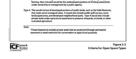
20 Next Steps Complete Chapter 3 (Conservation Strategy) and Chapter 4 (Implementation) June Agst August. Receive comments on Draft Chapters 1 (Introduction) and 2 (Environmental Setting) through July. Receive comments on Chapters 3 and 4 through August/September. Next Public meeting ~September/October. Upcoming Events UAG meetings each month (third Thursday). Discussion i of Chapter 2 Components of the Conservation Strategy Conservation Goals for east Alameda County Implementation of the EACCS Alameda County RCD Land Owner meeting Public meeting ~September/October to coincide with the release of the Public Draft EACCS. 20
21 Perspectives on the EACCS Steering Committee California Department of Fish and Game User s Advisory Group Questions? 21
22 Communications Tools Weblink: EACCS Coordinator Mary Lim
Antioch Habitat Conservation Plan/Natural Community Conservation Plan
 Antioch Habitat Conservation Plan/Natural Community Conservation Plan Science Advisor Workshop February 8, 2018 Kathryn Gaffney Project Manager Matt Ricketts Lead Biologist 1 PRESENTATION OUTLINE Background
San Francisco Bay Area Upland Habitat Goals Project
 San Francisco Bay Area Habitat Preserving Biological Diversity for Future Generations A of the Bay Area Open Space Council funding provided by: California State Coastal Conservancy Gordon and Betty Moore
APPENDIX C NATURAL RESOURCES MANAGEMENT PLAN: ACTIONS AND PRIORITIES
 APPENDIX C NATURAL RESOURCES MANAGEMENT PLAN: ACTIONS AND PRIORITIES TABLE C-1: Resource Actions and Priorities GOAL NRM-4 Objective 4.1: Restore Natural floodplain functions. Objective 4.2: Define and
Goleta Community Plan Update
 Goleta Community Plan Update Ecology, Biology, and Habitats GVPAC Meeting Agenda [Wednesday, December 17, 2008, 6:00PM] Pledge of Allegiance and Roll Call Public Comment Period Administrative December
3.10 Land Use and Planning
 3.10 This section describes the regulatory and environmental setting for land use and planning in the program and individual project areas. It also describes impacts on land use and planning that could
Florida s Ephemeral Ponds and Pond-Breeding Amphibians
 Florida s Ephemeral Ponds and Pond-Breeding Amphibians What are Ephemeral Ponds? Ephemeral ponds are small, isolated wetlands that dry periodically. These ponds can be deep, sand-bottomed depressions with
Planning for Staten. Habitat Restoration and Green Infrastructure. Island s North Shore
 Habitat Restoration and Green Infrastructure Planning for Staten Island s North Shore Community Board 1 March 1, 2018 NYC Parks Forestry, Horticulture, and Natural Resources Funded by the NYS Department
Community Conservation Workshop. Lake Placid
 Community Conservation Workshop Lake Placid 2 Community Conservation Program Welcome! We have designed a Community Conservation Program that listens to the needs of community members. We are conducting
Biodiversity Conservation
 Biodiversity Conservation and Site Plan Review Biodiversity conservation principles Threats to biodiversity Location of development Reviewing site plans Lunch Reviewing site plans (continued) LEED and
Conservation Plan. I. Property Information. II. Objectives. Natural Resource Objectives. Sustainability in Practice (SIP) Certified
 Certified") Conservation Plan Sustainability in Practice (SIP) Certified I. Property Information Vineyard Name and Establishment Date: Location: Map (attach showing blocks and acres): II. Objectives Natural Resource
Conservation Plan Sustainability in Practice (SIP) Certified I. Property Information Vineyard Name and Establishment Date: Location: Map (attach showing blocks and acres): II. Objectives Natural Resource
An Update on the Air Force Pilot Project: Developing the Florida Strategic Plan for Sustaining Military Readiness through Conservation Partnerships
 An Update on the Air Force Pilot Project: Developing the Florida Strategic Plan for Sustaining Military Readiness through Conservation Partnerships 18 November 2015 Quick Overview Pilot Project Background
6.1. East Bay Regional Conservation Investment Strategy (RCIS) Regional Advance Mitigation Planning (RAMP) Alameda County Technical Advisory Committee
 Regional Advance Mitigation Planning (RAMP) Alameda County Technical Advisory Committee") 6.1 Replace with photo from CC/AC East Bay Regional Conservation Investment Strategy (RCIS) Regional Advance Mitigation Planning (RAMP) Alameda County Technical Advisory Committee Liz O Donoghue The Nature
6.1 Replace with photo from CC/AC East Bay Regional Conservation Investment Strategy (RCIS) Regional Advance Mitigation Planning (RAMP) Alameda County Technical Advisory Committee Liz O Donoghue The Nature
Countywide Green Infrastructure
 Montgomery County s Countywide Green Infrastructure F U N C T I O N A L M A S T E R P L A N The Maryland National Capital Park and Planning Commission INFRASTRUCTURE An underlying base or foundation especially
OPEN SPACE CHAPTER 7: OVERVIEW. Preserve open space to protect natural resources, enhance character and provide passive recreation opportunities
 CHAPTER 7: OPEN SPACE OVERVIEW Ridgefield has made tremendous progress permanently preserving areas of town as open space. Open space preservation can serve many important purposes, including: protect
Community Conservation Workshop. Saranac River Basin Communities
 Community Conservation Workshop Saranac River Basin Communities 2 Community Conservation Program Welcome! We have designed a Community Conservation Program that listens to the needs of community members.
CHINO HILLS CHINO HILLS. September 6, 2012 OPEN SPACE MANAGEMENT PLAN
 September 6, 2012 Welcome! Today s Agenda Introduction Purpose and Scope of the Open Space Management Plan Where Have We Been? Presentation of Preliminary Findings Exercise: Issue identification and Priority
5. Environmental Analysis
 5.3 BIOLOGICAL RESOURCES 5.3.1 Methodology The following assessment of biological resources is based on historical information compiled through previous documentation and appropriate reference materials.
The Conservation Lands Network
 The Conservation Lands Network CLN 1.0 Progress Report Think Big. Connect More. www.bayarealands.org Table of Contents Foreword...i 1 The Conservation Lands Network...1 2 CLN 1.0 Progress Report...9 3
5 ENVIRONMENTAL RESOURCES ELEMENT
 5 ENVIRONMENTAL RESOURCES ELEMENT 5.1 PURPOSE This section identifies environmentally sensitive resources found within the Rio Del Oro Specific Plan (RDOSP) Area and outlines policies to guide the conservation,
Open Space Element. General Plan. County of Sacramento Community Planning and Development Department
 General Plan Open Space Element Adopted December 15, 1993 Amended November 9, 2011 County of Sacramento Community Planning and Development Department This Page blank. Table of Contents SECTION I... 1 OPEN
Executive Summary. Essential Connectivity Map (Figure ES-1)
") Executive Summary The California Department of Transportation (Caltrans) and California Department of Fish and Game (CDFG) commissioned the because a functional network of connected wildlands is essential
Executive Summary The California Department of Transportation (Caltrans) and California Department of Fish and Game (CDFG) commissioned the because a functional network of connected wildlands is essential
ROBERT SIBLEY VOLCANIC REGIONAL PRESERVE LAND USE PLAN AMENDMENT COMMUNITY MEETING #2 NOVEMBER 16, 2016
 ROBERT SIBLEY VOLCANIC REGIONAL PRESERVE LAND USE PLAN AMENDMENT COMMUNITY MEETING #2 NOVEMBER 16, 2016 Presentation Overview Introduction Project Overview LUPA Project Status Technical studies Preliminary
ROLE OF LANDSCAPE CONSERVATION COOPERATIVES IN EVERGLADES RESTORATION
 ROLE OF LANDSCAPE CONSERVATION COOPERATIVES IN EVERGLADES RESTORATION GEER April 2017 Steve Traxler 1, Todd Hopkins 1, Beth Stys 2 1 US Fish and Wildlife Service 2 Florida Fish & Wildlife Conservation
Baylands Segment J. Bay between the Golden Gate and Segment J. Coyote Point. of For managed ponds. included habitat enhancement.
 Baylands Segment J Crissy Field Alameda Naval Air Station Heron's Head Park COLMA CREEK SFO Millbrae San Mateo BAYLANDS 2009 SAN FRANCISCO AREA san francisco area Western side of central San Francisco
Brockton. Produced in This report and associated map provide information about important sites for biodiversity conservation in your area.
 CONSERVING THE BIODIVERSITY OF MASSACHUSETTS IN A CHANGING WORLD Brockton Produced in 2012 This report and associated map provide information about important sites for biodiversity conservation in your
Port of San Diego Sea Level Rise Ad Hoc Committee Meeting 1 of 3.. September 18, 2018
 Port of San Diego Sea Level Rise Ad Hoc Committee Meeting 1 of 3. September 18, 2018 Agenda Welcome Introductions Rules of the Ad-Hoc Presentation Background Vulnerability Assessment Results Non-Agenda
Planning for Staten. Habitat Restoration and Green Infrastructure. Island s North Shore
 Habitat Restoration and Green Infrastructure Planning for Staten Island s North Shore Walker Park December 7, 2017 NYC Parks Forestry, Horticulture, and Natural Resources Funded by the NYS Department of
CHAPTER 10-D GREATER MONTEREY PENINSULA AREA PLAN
 CHAPTER 10-D GREATER MONTEREY PENINSULA AREA PLAN GREATER MONTEREY PENINSULA AREA PLAN SUPPLEMENTAL POLICIES 1.0 - Land Use GMP-1.1 GMP-1.2 GMP-1.3 GMP-1.4 GMP-1.5 GMP-1.6 GMP-1.7 The County shall overlay
Florida Forever Conservation Needs Assessment Overview Maps
 Florida Forever Conservation Needs Assessment Overview Maps Prepared by Florida Natural Areas Inventory, The maps in this document are derived from the Florida Forever Conservation Needs Assessment, an
Minnesota Department of Natural Resource - Natural Resource Guidance Checklist Conserving Natural Resources through Density Bonuses
 Minnesota Department of Natural Resource - Natural Resource Guidance Checklist Conserving Natural Resources through Density Bonuses NRDB Why Use Density Bonuses & This Checklist Local units of government
SITE INTRODUCTIONS AND OVERVIEW
 SITE INTRODUCTIONS AND OVERVIEW The City s formal Open Space Program was established in 1990 to implement long-standing policies that called for the protection of the farmlands and wild areas that surround
Dedham. Produced in This report and associated map provide information about important sites for biodiversity conservation in your area.
 CONSERVING THE BIODIVERSITY OF MASSACHUSETTS IN A CHANGING WORLD Dedham Produced in 2012 This report and associated map provide information about important sites for biodiversity conservation in your area.
Regional Open Space Conservation Plan. Regional Staff Committee January 18, 2018
 Regional Open Space Conservation Plan Regional Staff Committee January 18, 2018 Schedule We are here Task 1 - Stakeholder Input & Work Plan Dev. v z 2016 2017 2018 Oct Nov Dec Jan Feb Mar Apr May Jun Jul
Planning and Building Inspection Department Mitigation Monitoring Reporting Plan (MMRP) Potrero Subdivision Santa Lucia Preserve
 Potrero Subdivision Santa Lucia Preserve") Planning and Building Inspection Department Mitigation Monitoring Reporting Plan (MMRP) Potrero Subdivision Santa Lucia Preserve Project Name: Potrero Area Subdivision File No: PLN010001 APNs: 239-102-001-000;
Planning and Building Inspection Department Mitigation Monitoring Reporting Plan (MMRP) Potrero Subdivision Santa Lucia Preserve Project Name: Potrero Area Subdivision File No: PLN010001 APNs: 239-102-001-000;
Using the Past to Understand the Present Emerging Lessons for Environmental Planning in the Santa Clara Valley
 Using the Past to Understand the Present -- -- -- Emerging Lessons for Environmental Planning in the Santa Clara Valley Robin Grossinger Director of the Historical Ecology Program San Francisco Estuary
ADDENDUM TO BIOLOGICAL SCOPING SURVEY REPORT, BOTANICAL SURVEY AND WETLAND DELINEATION
 ADDENDUM TO BIOLOGICAL SCOPING SURVEY REPORT, BOTANICAL SURVEY AND WETLAND DELINEATION FOR AVALON INN (APN 069-241-27 & -04) 1201 & 1211 NORTH MAIN STREET FORT BRAGG, CA MENDOCINO COUNTY prepared for:
Executive Summary Purpose of the Plan Defining Open Space and Greenways
 Executive Summary Bucks County possesses a vast array of open space resources including natural areas, parks, farmland and historic and cultural resources that contribute to a high quality of life valued
Peninsular Florida Landscape Conservation Cooperative. Marine and Estuarine Priority Resources and Conservation Targets
 Peninsular Florida Landscape Conservation Cooperative Marine and Estuarine Priority Resources and Conservation Targets Why are we here today? Workshop Goals: Develop a list of potential conservation targets
3-2 Environmental Systems
 3-2 Environmental Systems 3.0 ENVIRONMENTAL SYSTEMS CONTENTS 3.1 GREENWAY SYSTEM 3.1.1 General Policies 3.1.2 Natural Heritage Network 3.1.3 Natural Heritage Network Enhancement Lands 3.1.4 Rouge Watershed
COLORADO S Comprehensive Wildlife Conservation Strategy Linking Conservation and Transportation Planning August 15, 2006
 COLORADO S Comprehensive Wildlife Conservation Strategy Linking Conservation and Transportation Planning August 15, 2006 The Input Process Input from DOW experts List of scientific experts Mailing to 1000
CHAPTER 10-D GREATER MONTEREY PENINSULA AREA PLAN
 CHAPTER 10-D GREATER MONTEREY PENINSULA AREA PLAN GREATER MONTEREY PENINSULA AREA PLAN SUPPLEMENTAL POLICIES 1.0 - Land Use GMP-1.1 GMP-1.2 GMP-1.3 GMP-1.4 GMP-1.5 GMP-1.6 GMP-1.7 GMP-18.6 The County shall
Riparian Buffer on the Bushkill Creek. Policies
 Riparian Buffer on the Bushkill Creek Riparian buffers provide numerous benefits to landowners and the community by protecting groundwater recharge areas, providing flood control, providing stormwater
Pequotsepos Brook Preserve
 AVALONIA LAND CONSERVANCY, Inc. P.O. Box 49, Old Mystic, CT 06372 Pequotsepos Brook Preserve Property Management Plan Maritime Drive Mystic, New London County, Connecticut Stonington Town Committee is
Town of Sahuarita Open Space Plan Element. University of Arizona Planning Program Projects Team
 Town of Sahuarita Open Space Plan Element University of Arizona Planning Program Projects Team Introduction Planning students in the Planning Program Project Class Overall Goal Potential uses of $1.5 Million
Burrowing Owl Habitat Project at the Albany Plateau. (a component project of the Gilman Street Playing Fields Project City of Berkeley) March 10, 2006
 March 10, 2006") Burrowing Owl Habitat Project at the Albany Plateau (a component project of the Gilman Street Playing Fields Project City of Berkeley) March 10, 2006 Submitted by The City of Berkeley Project history During
Burrowing Owl Habitat Project at the Albany Plateau (a component project of the Gilman Street Playing Fields Project City of Berkeley) March 10, 2006 Submitted by The City of Berkeley Project history During
COASTAL CONSERVANCY. Staff Recommendation March 25, 2004 LOS ANGELES GREEN VISION PLAN. File No.: Project Manager: Marc Beyeler
 COASTAL CONSERVANCY Staff Recommendation March 25, 2004 File No.: 04-014 Project Manager: Marc Beyeler RECOMMENDED ACTION: Authorization to disburse up to $50,000 to the University of Southern California
DRAFT MAP AMENDMENT FLU 04-4
 DRAFT MAP AMENDMENT FLU 04-4 SW 24 TH AVENUE ROADWAY CORRIDOR The University of Florida participates with the Metropolitan Transportation Planning Organization (MTPO) in its responsibilities for the continuing,
Coyote Hills Restoration and Public Access Project Coyote Hills Regional Park C o n c e p t P l a n a n d S i t e P r o g r a m
 Coyote Hills Restoration and Public Access Project Coyote Hills Regional Park C o n c e p t P l a n a n d S i t e P r o g r a m Chris Barton Environmental Programs Manager Aquisition Stewardship Development
Conservation Corridor Planning and Green Infrastructure Themes
 Conservation Corridor Planning and Green Infrastructure Themes Prepared by the Green Infrastructure Center Inc. and the Northern Virginia Regional Commission February 22, 2011 Brief Overview Project Background
Planning for and Managing Open Space and Natural Areas
 Planning for and Managing Open Space and Natural Areas Increasingly, development proposals in Delaware include large amounts of open space and natural areas. While open space is important as a community
ADOPTED CAPITAL IMPROVEMENT PROGRAM BUDGET ARROYO PROJECTS
 ADOPTED CAPITAL IMPROVEMENT PROGRAM BUDGET ARROYO PROJECTS HAHAMONGNA FY 212-216 Capital Improvement Program Priority Description Total Estimated Costs Appropriated Through FY 211 Adopted FY 212 FY 213
Verde Valley Landscape Character Type
 Existing Condition Landscape Character The existing landscape character describes the existing set of valued aesthetic attributes for the current landscape. The landscape character descriptions include
TOWN OF BETHLEHEM OPEN SPACE CONSERVATION PLAN PUBLIC MEETING: OCTOBER 12, 2017
 TOWN OF BETHLEHEM OPEN SPACE CONSERVATION PLAN PUBLIC MEETING: OCTOBER 12, 2017 Welcome and Agenda 6:00 6:45: Open House, Part One 6:45 7:15: Presentation and Questions 7:15 8:00: Open House, Part Two
[FWS R8 R 2015 N087; FXRS282108E8PD0 156 F ] South Bay Salt Pond Restoration Project, Phase 2; Don Edwards National Wildlife
![[FWS R8 R 2015 N087; FXRS282108E8PD0 156 F ] South Bay Salt Pond Restoration Project, Phase 2; Don Edwards National Wildlife](/thumbs/84/90602803.jpg "[FWS R8 R 2015 N087; FXRS282108E8PD0 156 F ] South Bay Salt Pond Restoration Project, Phase 2; Don Edwards National Wildlife") Surname Billing Code: 4310 55 Deputy RD ARD Refuges DEPARTMENT OF THE INTERIOR Fish and Wildlife Service Solicitor Refuge Supervisor Asst. Refuge Supervisor Ch. Natural Resources Project Leader [FWS R8
Surname Billing Code: 4310 55 Deputy RD ARD Refuges DEPARTMENT OF THE INTERIOR Fish and Wildlife Service Solicitor Refuge Supervisor Asst. Refuge Supervisor Ch. Natural Resources Project Leader [FWS R8
Photo by Carlton Ward Jr. Executive Summary
 Photo by Carlton Ward Jr. Executive Summary The Cooperative Conservation Blueprint (Blueprint) is a multi-partner strategic conservation process developed by the Florida Fish and Wildlife Commission (FWC)
Improving Communities Through the Arroyo Seco Sustainability Campaign and Watershed Assessment
 Improving Communities Through the Arroyo Seco Sustainability Campaign and Watershed Assessment Arroyo Seco Headwaters in the San Gabriel Mountains Major tributary to the Los Angeles River 44 square mile
Department of Community Development. Planning and Environmental Review Division Revised Notice of Preparation
 Department of Community Development Michael J. Penrose, Acting Director Divisions Building Permits & Inspection Code Enforcement County Engineering Economic Development & Marketing Planning & Environmental
NOTICE OF PREPARATION
 NOTICE OF PREPARATION DATE: January 6, 2016 TO: LEAD AGENCY: Responsible Agencies, Organizations, and Interested Parties Contact: Tyler Barrington, Principal Planner Planning Department Community Development
Regional Open Space Conservation Plan Putting the Plan into Action
 Regional Staff Committee June 21, 2018 Regional Open Space Conservation Plan Putting the Plan into Action Comments on the draft Include more discussion of urban open space Benefits, challenges to maintaining/increasing
Public Review Draft Oceanside Subarea Habitat Conservation Plan/ Natural Communities Conservation Plan
 Oceanside Subarea Habitat Conservation Plan/ Natural Communities Conservation Plan Prepared for City of Oceanside Planning Department 300 N. Coast Highway Oceanside, CA 92054 Prepared by Ogden Environmental
Table of Contents. Executive Summary...S-1
 Table of Contents Executive Summary...S-1 1: Project Description... 1-1 A. Project Identification... 1-1 B. Background to the Proposed Project... 1-5 C. Description of the Project Site... 1-8 D. Description
Network Chapter Leader Handbook and Other Updates from the October Advisory Board Meeting
 Volume 51 September/October 2018 Welcome to the September/October Network Pulse Newsletter. The Network Advisory Board is excited to announce the release of the Draft Community Leader Handbook and some
Appendix Q. Baseline Biology Report
 Appendix Q Baseline Biology Report A u g u s t 2 0 1 4 (DRECP) Baseline Biology Report Prepared for: California Energy Commission 1516 Ninth Street Sacramento, California 95814 Under Contract to: Aspen
Landscape Conservation Design April, 2014
 Designing Sustainable Landscapes in the Northeast A project of the North Atlantic Landscape Conservation Cooperative & Northeast Climate Science Center Landscape Conservation Design April, 2014 Conceptual
Table of Contents TABLE OF CONTENTS SECTION TITLE PAGE
 TABLE OF CONTENTS SECTION TITLE PAGE 1 INTRODUCTION AND OVERVIEW 1-1 1.1 Purpose and Need 1-1 1.2 Goals and Objectives 1-3 1.3 Overview of the Planning Process 1-5 1.4 Federal and State Requirements and
TABLE OF CONTENTS. Tables Table UC Davis Park and Open Space Resources
 TABLE OF CONTENTS 4.13 Recreation... 4.13-1 4.13.1 Environmental Setting... 4.13-1 4.13.2 Impacts and Mitigation Measures... 4.13-4 4.13.3 References... 4.13-8 Tables Table 4.13-1 UC Davis Park and Open
Meeting Agenda. City of Guelph. River Systems Advisory Committee. Agenda Items. Item 1, 2 and 3. Item 4 Ward to Downtown Pedestrian Bridge
 Meeting Agenda City of Guelph River Systems Advisory Committee September 19, 2018 City Hall, Meeting Room B From 4:00 to 6:00 p.m. Meeting Chair: Mariette Pushkar Agenda Items Welcome to all Item 1, 2
Developing Landscape Conservation Designs & Adaptation Strategies for the GCPO LCC
 Developing Landscape Conservation Designs & Adaptation Strategies for the GCPO LCC D. Todd Jones-Farrand Science Coordinator david_jones-farrand@fws.gov 29-30 June 2015 Replace this box with key image
Memorandum Planning. Thursday, January 8, 2015
 Memorandum Planning Thursday, January 8, 2015 7.A. To: Coastal Advisory Committee From John Ciampa, Associate Planner Subject: Review Draft Local Coastal Program Copies: James Pechous, City Planner Purpose
McArthur Swamp Planning Unit. Fish, Plant, and Wildlife Habitat MCARTHUR SWAMP PLANNING UNIT
 McArthur Swamp Planning Unit Fish, Plant, and Wildlife Habitat Conduct surveys of the planning unit to identify biological resources and enable their protection. Most of the McArthur Swamp land acreage
TOTAL $795,376 $1,169,593
 2013 California Fire Safe Clearinghouse Grant Awards Cohesive Wildland Fire Management Strategy Focus- X Organization Name Project Name Funded Amount Match Provided Big Sur Land Trust Glen Deven Fuels
Isabel Neighborhood Plan: Alternatives
 Isabel Neighborhood Plan: Alternatives Presented by: Lori Parks, Associate Planner February 2, 2015 Agenda 1. Background on BART to Livermore 2. Isabel Neighborhood Plan 3. Alternative Scenarios 4. General
SOUTHWEST CORRIDOR EXTENSION. Environmental Evaluation and Basic Engineering Results PUBLIC MEETING/OPEN HOUSE November 18, 2009
 SOUTHWEST CORRIDOR EXTENSION Environmental Evaluation and Basic Engineering Results PUBLIC MEETING/OPEN HOUSE November 18, 2009 AGENDA I. Welcome/Introductions II. Project Review and Status III. Environmental
At the Heart of the Great Lakes
 Walpole Island Heritage Centre May 2010 At the Heart of the Great Lakes Bkejwanong: Where the Waters Divide Bkejwanong s Ecosystems OVERVIEW Walpole Island supports a rich mosaic of natural areas including
6 COMMUNITY SERVICES AND FACILITIES
 6 COMMUNITY SERVICES AND FACILITIES 6.1 PARKS AND OPEN SPACE The Hecker Pass Specific Plan provides over 98 acres of public parks and open space as shown in Figure 6-1. The bulk of this acreage is located
APPENDIX I Presentations
 APPENDIX I Presentations Workshop Summary Report 11 Peel Region Official Plan Review May 5, 2010 Compatible Active Recreation Workshop July 29, 2010 Components of PROPR Sustainability Planning Tools/Updates
The Napa River Flood Protection Project
 The Napa River Flood Protection Project Creating Flood Protection and Restoring Geomorphic and Biological Processes Jeremy Sarrow, Napa County Flood Control & Water Conservation District June 2, 2014.
Whitemarsh Comprehensive Plan Update: Housing & Land Use. Public Workshop #3: September 20, 2018
 Whitemarsh Comprehensive Plan Update: Housing & Land Use Public Workshop #3: September 20, 2018 Agenda Welcome Process Recap What We ve Heard The Plan Framework Review of Recommended Actions Land Use Housing
Conserving Ca[ifomiaJs Wi[tf[ife Si~e 1870
 State of California - The Resources Aqency DEPARTMENT OF FISH AND GAME huo:/ /www.dfg.ca.gov POST OFFICE BOX 47 YOUNTVillE, CALIFORNIA 94599 (707) 944-5500 ARNOLD SCHWARZENEGGER. Governor October 5,2007
Ventura County Stormwater Technical Guidance Manual
 Ventura County Stormwater Technical Guidance Manual City of San Buenaventura Standard Construction Details c. Technical Guidance Manual for Stormwater Quality Control Measures d. County of Ventura Standard.
The scope of the plan will focus on the Prospect Heights Slough and Hillcrest Lake as one entity.
 Plan for Prospect Heights Natural Resources Commission Plan for Improved Public Access and Enjoyment of the Prospect Heights Slough and Hillcrest Lake July 23, 2018 The City Council has requested the Natural
APPENDIX 1: SCOPED ENVIRONMENTAL IMPACT STATEMENT (EIS) FORM
 FORM") APPENDIX 1: SCOPED ENVIRONMENTAL IMPACT STATEMENT (EIS) FORM This form is intended for use by applicants (primarily private landowners) who need to conduct a Scoped EIS in support of minor development
APPENDIX 1: SCOPED ENVIRONMENTAL IMPACT STATEMENT (EIS) FORM This form is intended for use by applicants (primarily private landowners) who need to conduct a Scoped EIS in support of minor development
This page intentionally blank.
 This page intentionally blank. Parks, Recreation, and Open Space Chapter Relationship to Vision Vision Parks, Recreation and Open Space Chapter Concepts County Government. County government that is accountable
FEGN Update Goals and Objectives
 FEGN Update Goals and Objectives Update the FEGN to identify a functionally connected statewide ecological network of public and private conservation lands that incorporates new and updated GIS data. Ensure
ALUS Alberta Municipal Alliance & ALUS Canada
 ALUS Alberta Municipal Alliance & ALUS Canada The Alberta Common Ground Alliance and the Alberta Public Works Association, Alberta s New Wetlands Policy Red Deer, February 4, 2016 Daryl Watt, Reeve, County
2 PLANNING AREA DESCRIPTION
 2 PLANNING AREA DESCRIPTION 2.1 LOCATION Hecker Pass is located within the City of Gilroy near the western city limit. Figure 2-1 illustrates the regional location of the Hecker Pass Area. Figure 2-1:
RECREATION, OPEN SPACE AND GREENWAYS ELEMENT GOALS, OBJECTIVES, AND POLICIES
 RECREATION, OPEN SPACE AND GREENWAYS ELEMENT GOALS, OBJECTIVES, AND POLICIES GOAL R-1: DEVELOP A RECREATION, OPEN SPACE AND GREENWAYS SYSTEM AS AN INTEGRAL COMPONENT OF AN OVERALL, COUNTY-WIDE ECONOMIC
ADOPTION OF THE REVISED OPEN SPACE AND CONSERVATION ELEMENT OF THE GENERAL PLAN
 TO: FROM: SUBJECT: Honorable Mayor and City Council Planning Department ADOPTION OF THE REVISED OPEN SPACE AND CONSERVATION ELEMENT OF THE GENERAL PLAN RECOMMENDATION: It is recommended that the City Council:
March 21, Mayor Gillmor and Santa Clara City Council members City of Santa Clara 1500 Warburton Avenue Santa Clara, CA 95050
 March 21, 2016 Mayor Gillmor and Santa Clara City Council members City of Santa Clara 1500 Warburton Avenue Santa Clara, CA 95050 Re: Santa Clara City Place - Comments for Study Sessions Honorable Mayor
Setting a Course for a Sustainable Landscape
 Setting a Course for a Sustainable Landscape Landscape Conservation Cooperatives: Geographic Areas SALCC Basics 89 million acres Over 18,000 miles of shoreline (calculated from the NOAA Medium Resolution
3. VISION AND GOALS. Vision Statement. Goals, Objectives and Policies
 Vision Statement Queen Creek s interconnected network of parks, trails, open spaces and recreation opportunities provide safe and diverse activities and programs that sustain its unique, small town, equestrian
Comprehensive Park System Master Plan
 PARKS AND RECREATION Comprehensive Park System Master Plan Citizen Advisory Committee, June 5, 2012 - Meeting Notes Transcription MIG met with the Parks Citizen Advisory Committee on Tuesday, June 5th,
Central Lake Ontario Conservation Conservation Lands Master Plan
 Conservation Lands Master Plan Top 13 Frequently Asked Questions 1. What are conservation lands? Where are these conservation lands located in the Central Lake Ontario Conservation watershed? Conservation
COASTAL CONSERVANCY. Staff Recommendation June 5, 2008 SAN DIEGO RIVER TRIBUTARY CANYONS PROJECT. File No Project Manager: Megan Johnson
 COASTAL CONSERVANCY Staff Recommendation June 5, 2008 SAN DIEGO RIVER TRIBUTARY CANYONS PROJECT File No. 08-059 Project Manager: Megan Johnson RECOMMENDED ACTION: Authorization to disburse an amount not
KEEPING IT GREEN IN THE MIDLANDS: Preserving Open Space in South Carolina s Capitol Region
 KEEPING IT GREEN IN THE MIDLANDS: Preserving Open Space in South Carolina s Capitol Region Introduction The Central Midlands Council of Governments (CMCOG) has been working to produce a concept document
4. ENVIRONMENTAL IMPACT ANALYSIS 7. LAND USE AND PLANNING
 4. ENVIRONMENTAL IMPACT ANALYSIS 7. LAND USE AND PLANNING 4.7.1 INTRODUCTION The following analysis discusses the consistency of the Proposed Project with the corresponding land use and zoning designations
Blue/Green Infrastructure Study Accomack County, VA
 Blue/Green Infrastructure Study Accomack County, VA Draft Asset Maps March 8-9, 2010 Green Infrastructure Center, Inc. 2 Overview What is Green and Blue Infrastructure Project Timeline & Tasks Literature
PICTURE CANYON Planning Riparian-Wetland Refugia in an Urban Setting
 PICTURE CANYON Planning Riparian-Wetland Refugia in an Urban Setting Rio De Flag Existing Conditions. Ephemeral stream; Limited riparian plants, habitats.. & Opportunities Water (effluent) available Restore
TO MEMBERS OF THE COMMITTEE ON GROUNDS AND BUILDINGS:
 Office of the President June 22, 2004 102 TO MEMBERS OF THE COMMITTEE ON : For Meeting of ITEM FOR ACTION Click here for EXECUTIVE SUMMARY CERTIFICATION OF ENVIRONMENTAL IMPACT REPORT AND APPROVAL OF DESIGN,
Baylands Segment P. 206 The Baylands and Climate Change: What We Can Do COYOTE CREEK
 Baylands Segment P BAYLANDS coyote 2009 creek area COYOTE Southern CREEK end of San Francisco Bay AREA between Alviso Slough and Albrae Slough Southern end of San Francisco Bay Baylands between Alviso