Planning and Development Committee
|
|
|
- Matthew Pearson
- 5 years ago
- Views:
Transcription
1 Planning and Development Committee Date 2019/03/04 Time 1:30 PM Location Civic Centre, Council Chamber, 300 City Centre Drive, Mississauga, Ontario, L5B 3C1 Members Councillor George Carlson Ward 11 (Chair) Mayor Bonnie Crombie Councillor Stephen Dasko Ward 1 Councillor Karen Ras Ward 2 Councillor Chris Fonseca Ward 3 Councillor John Kovac Ward 4 Councillor Carolyn Parrish Ward 5 Councillor Ron Starr Ward 6 Councillor Dipika Damerla Ward 7 Councillor Matt Mahoney Ward 8 Councillor Pat Saito Ward 9 Councillor Sue McFadden Ward 10 Contact Angie Melo, Legislative Coordinator, Legislative Services ext angie.melo@mississauga.ca Find it Online Meetings of Council streamed live and archived at Mississauga.ca/videos
2 Planning and Development Committee 2019/03/04 2
3 Planning and Development Committee 2019/03/04 3 PUBLIC MEETING STATEMENT: In accordance with the Ontario Planning Act, if you do not make a verbal submission to the Committee or Council, or make a written submission prior to City Council making a decision on the proposal, you will not be entitled to appeal the decision of the City of Mississauga to the Local Planning and Appeals Tribunal (LPAT), and may not be added as a party to the hearing of an appeal before the LPAT. Send written submissions or request notification of future meetings to: Mississauga City Council Att: Development Assistant c/o Planning and Building Department 6 th Floor 300 City Centre Drive, Mississauga, ON, L5B 3C1 Or application.info@mississauga.ca 1. CALL TO ORDER 2. DECLARATION OF CONFLICT OF INTEREST 3. MINUTES OF PREVIOUS MEETING Approval of Minutes of February 19, 2019, 1:30 PM and 6:30 PM Sessions 4. MATTERS TO BE CONSIDERED 4.1. PUBLIC MEETING INFORMATION REPORT (WARD 1) Applications to permit a 4 to 12 storey apartment building proposing 397 units and ground floor commercial facing Lakeshore Road East 1345 Lakeshore Road East, northwest corner of Lakeshore Road East and Dixie Road Owner: Vandyk Group of Companies File: OZ 18/009 W1 Bill PUBLIC MEETING INFORMATION REPORT (WARD 7) Applications to permit 112 Back to Back Stacked Townhomes 2512, 2522 and 2532 Argyle Road, south of Dundas Street West, west of Confederation Parkway Owner: Plazacorp Properties Limited (by Agreement of Purchase and Sale) File: OZ 18/017 W7 Bill 139
4 Planning and Development Committee 2019/03/ PUBLIC MEETING INFORMATION REPORT (WARD 3) Applications to permit two new 8 storey rental apartment buildings consisting of 202 residential units 1485 Williamsport Drive and 3480 Havenwood Drive, northwest corner of Williamsport Drive and Havenwood Drive Owner: Starlight Group Property Holdings Inc. File: OZ 18/014 W3 Bill PUBLIC MEETING INFORMATION REPORT (WARD 5) Applications to permit six condominium apartment buildings with 2,668 units and heights of 28, 33, 35, 40, 40 and 45 storeys, 14 three storey condominium townhomes, 4 three storey common element condominium townhomes, and a public park 91 and 131 Eglinton Avenue East and 5055 Hurontario Street North side of Eglinton Avenue East, East of Hurontario Street Owner: Liberty Development Corporation (91 Eglinton Limited Partnership) File: T-M18005 W5 and OZ 18/016 W5 Bill RECOMMENDATION REPORT (WARD 11) Application to permit a six storey self storage facility 250 Derry Road West, south side of Derry Road West, east of McLaughlin Road Owner: Derry Storage Corporation File: OZ 17/019 W11 Bill ADJOURNMENT
5 Date: February 8, 2019 To: Chair and Members of Planning and Development Committee From: Andrew Whittemore, M.U.R.P., Commissioner of Planning and Building Originator s file: OZ 18/009 W1 Meeting date: 2019/03/04 Subject PUBLIC MEETING INFORMATION REPORT (WARD 1) Applications to permit a 4 to 12 storey apartment building proposing 397 units and ground floor commercial facing Lakeshore Road East 1345 Lakeshore Road East, northwest corner of Lakeshore Road East and Dixie Road Owner: Vandyk Group of Companies File: OZ 18/009 W1 Bill 139 Recommendation That the report dated February 8, 2019, from the Commissioner of Planning and Building regarding the applications by Vandyk Group of Companies to permit a 4 to12 storey apartment building proposing 397 units and ground floor commercial facing Lakeshore Road East, under File OZ 18/009 W1, 1345 Lakeshore Road East, be received for information. Background The applications have been deemed complete and circulated for technical comments. The purpose of this report is to provide preliminary information on the applications and to seek comments from the community. The report consists of two parts, a high level overview of the applications and a detailed information and preliminary planning analysis (Appendix 1). PROPOSAL The official plan amendment and rezoning applications are required to permit a 4 to 12 storey apartment building proposing 397 units and ground floor commercial facing Lakeshore Road East. The proposal includes underground parking and has vehicular access points on Dixie Road and St. James Avenue. The applicant is proposing to amend the Mixed Use Special Site 7 policies and Greenlands designation to reflect the additional height being sought and the delineation of the lands designated Greenlands associated with the Applewood Creek. The zoning will also need to change from C4-13 (Mainstreet Commercial) to C4 Exception (Mainstreet Commercial) and G1 (Greenlands Natural Hazards) to implement the proposal.
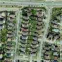
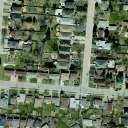
6 Planning and Development Committee 2019/02/08 2 Originator's file: OZ 18/009 W1 During the ongoing review of the applications, staff may recommend a different land use designations and zoning categories to implement the proposal. Comments The property is located on the northwest corner Dixie Road, (a Regional Major Collector road) and Lakeshore Road East, (an Arterial road) within the Lakeview Neighbourhood Character Area. The site is also subject to the Lakeview Local Area Plan and is considered within the Lakeshore Corridor Precinct Outer Core Area. The site previously operated as the former Sheridan Ford Car Dealership. The building is currently vacant. North of the subject property to the railway tracks are detached homes that are mostly bungalows. On the north side of the railway tracks is the Lakeview Golf Course. At the north east corner of the Lakeshore Road East and Dixie Road intersection is the Dixielake Plaza that has retail and commercial tenants. South of the site is the Small Arms Inspection Building on the former Arsenal Lands, which are currently owned by the City of Mississauga. West of the site contains the Green Acres motel and an apartment building. Applewood Creek is located just to the west of the site and is facilitated by a culvert under Lakeshore Road that has recently been expanded. Aerial image of 1345 Lakeshore Road East
7 Planning and Development Committee 2019/02/08 3 Applicant s rendering Originator's file: OZ 18/009 W1 LAND USE POLICIES AND REGULATIONS The relevant policies of Mississauga Official Plan are consistent with the Provincial Policy Statement (PPS), Growth Plan for the Golden Horseshoe (Growth Plan) and Regional of Peel Official Plan (ROP). No other provincial policies apply. The proposed development is generally consistent with the PPS and conforms to the Growth Plan and the ROP. The applicant is proposing to amend the special site policies that apply to the site. The request, and its conformity with the policies of Mississauga Official Plan, is under review. Additional information and details are found in Appendix 1, Section 6. AGENCY AND CITY DEPARTMENT COMMENTS Agency and department comments are summarized in Appendix 1, Section 9. Financial Impact All fees paid by developers are strictly governed by legislation, regulation and City by-laws. Fees are required to be paid prior to application approval, except where otherwise may be prescribed. These include those due to the City of Mississauga as well as any other external agency.
8 Planning and Development Committee 2019/02/08 4 Originator's file: OZ 18/009 W1 Conclusion All agency and City department comments have been received. The Planning and Building Department will make a recommendation on this project after the public meeting has been held and the issues, including the refinement of the access from Dixie Road and St. James Avenue and the delineation of the hazard lands associated with Applewood Creek, have been resolved. Attachments Appendix 1: Detailed Information and Preliminary Planning Analysis Andrew Whittemore, M.U.R.P., Commissioner of Planning and Building Prepared by: David Ferro, Development Planner
9 Appendix 1, Page 1 File: OZ 18/009 W1 Detailed Information and Preliminary Planning Analysis Owner: Vandyk Group of Companies Table of Contents 1. Site History Site Context Neighbourhood Context Project Details... 5 Concept Plan and Elevations Community Comments Land Use Policies and Regulations... 9 Excerpt of Lakeview Neighbourhood Character Area... 9 Existing Zoning and General Context...10 Proposed Zoning and General Context...10 Summary of Applicable Policies...11 Existing and Proposed Mississauga Official Plan Designation for the Subject Site...12 Existing Designation...12 Proposed Designation...12 Provincial Policy Statement (PPS) and Growth Plan Analysis...12 Consistency with Provincial Policy Statement Conformity with Growth Plan Region of Peel Official Plan...24 Relevant Mississauga Official Plan Policies...25 Lakeview Local Area Plan...32 Existing and Proposed Zoning Section 37 Community Benefits (Bonus Zoning) School Accommodation Development Issues...37 Development Requirements...41 Other Information...41
10 Appendix 1, Page 2 File: OZ 18/009 W1 1. Site History November 14, 2012 Mississauga Official Plan came into force except for those site/policies which have been appealed. The subject lands were designated Mixed Use Special Site 18 in the Lakeview Neighbourhood Character Area that allowed for a car dealership in addition to the uses permitted under the Mixed Use designation May 1, 2013 Applications for Official Plan Amendment and Rezoning submitted for the subject property, under file OZ 13/008 W1, from the previous property owner Lago Terrace Inc., which proposed a 10 storey apartment building October 14, 2015 Lakeview Local Area Plan came into force and is applicable to the subject property, which designated the subject property Mixed Use Special Site 7 maintaining the uses in the Mixed Use designation and adding townhouse dwellings as an additional permitted use October 3, 2017 Lago Terrace Inc. communicates to City staff that the proposal under file OZ 13/008 W1 will not be pursued and the file is subsequently cancelled by the applicant and closed June 3, 2018 Vandyk Group of Companies, new property owners of 1345 Lakeshore Road East, submit applications for Official Plan Amendment and Rezoning and is deemed complete
 and Dixie Road (a Regional Major Collector road) within the Lakeview Neighbourhood")
11 Appendix 1, Page 3 File: OZ 18/009 W1 2. Site Context The property is located on the northwest corner of Lakeshore Road East (a Major Collector road) and Dixie Road (a Regional Major Collector road) within the Lakeview Neighbourhood Character Area. Both roads traverse the City. The site was previously used for the Sheridan Ford Car Dealership. The building is currently vacant. At the northwest corner of the site there is a portion of the floodplain associated with Applewood Creek and regulated by Credit Valley Conservation. Lands west of Applewood Creek along the north side of Lakeshore Road East are characterized by apartment buildings ranging from 7 10 storeys and a motel. To the east, there is the Dixielake commercial plaza which has a tattoo parlour, spa and a discount store, among other tenants, Green Acres motel and lands are pending redevelopment for a 4 storey mixed use residential and commercial buildings. Opposite of the property, on the south side of Lakeshore Road East, is the Small Arms Inspection Building on lands that are currently owned by the Toronto Region Conservation Authority (TRCA), commonly known as the Arsenal Lands. The site is currently serviced by MiWay transit Routes 23 Lakeshore and 5 Dixie, with both routes terminating approximately one kilometre east of the site in the City of Toronto boundary at the Long Branch GO Station. The routes also provides service to the Dixie GO Station. Approximately 500 m (1,640.4 ft.) east of the site is a local neighbourhood park named Orchard Hill Park. In addition, approximately 2000 m (6, ft.) south east of the site is Lakefront Promenade Park, which is a large waterfront park with trails, baseball diamonds, volleyball courts, spray pads and a marina. Aerial Photo
 1.26 ha (3.12 ac.")
12 Appendix 1, Page 4 File: OZ 18/009 W1 Property Size and Use Frontages: Lakeshore Rd. E. Dixie Road St. James Ave Gross Lot Area: Existing Uses: m ( ft.) m ( ft.) m ( ft.) 1.26 ha (3.12 ac.) Former Sheridan Ford Car Dealership (now vacant) The surrounding land uses are: North: Detached homes, railway tracks and Lakeview Golf Course East: Commercial plaza (Dixielake Plaza) and detached homes South: Lands subject to Lakeview Village Masterplan, Small Arms Inspection Building West: Applewood Creek, Green Acres Motel and apartment Image of existing conditions facing north 3. Neighbourhood Context Demographics Lakeview Neighbourhood Character Area The subject property is located within a neighbourhood that is undergoing transition and growth. The surrounding residential neighbourhood was originally developed in the 1920s and 1930s with the majority of the residential built form being detached bungalows. The apartment building to the west was built in the 1990s. The population for the area is two-thirds middle aged, while children and seniors make up one-third of the population. On average, the number of people per household is three, with over half of the population living in detached dwellings. By 2031 and 2041, the population for this character area is forecasted to be 26,600, and 27,900, respectively. Other Development Applications East of the subject property, the City has been processing Site Plan applications for residential
13 Appendix 1, Page 5 File: OZ 18/009 W1 and commercial uses located at 1041 and 1407 Lakeshore Road East. West of the subject property and south of Lakeshore Road East are the former Ontario Power Generation lands that are currently undergoing a master planning exercise in anticipation of future development applications to accommodate a mixed use community of 6800 residential units and an innovation corridor. The City is undertaking a study called Lakeshore Connecting Communities that is reviewing future planning along the Lakeshore Road corridor. The intent of the study is to ensure that all modes of transportation can be accommodated within the corridor and will consider future options for the corridor. The Lakeview Neighbourhood Character Area has been subject to development activity in the form of infill intensification occurring in different parts of the neighbourhood and the construction of newer two storey detached homes replacing older detached bungalows. Community Facilities and Services The proposal is served by major City of Mississauga facilities such as Carmen Corbasson Community Centre (within 2 km), Lakeview Golf Course (within 300 m) and Lakeview Library (within 900 m). The site is also served by nearby Orchard Hill Park, Douglas Kennedy Park and Lakefront Promenade Park. In addition, there is planning for future parks and community facilities as part of the future major development located on the former Ontario Power Generation (OPG) lands. Additional comments from Community Services regarding City parks and facilities can be reviewed within Section 9 of this Appendix. 4. Project Details The applications are to permit a 4 to12 storey apartment building proposing 397 units, including townhouse units fronting onto St. James Avenue, and ground floor commercial uses facing Lakeshore Road East. The proposal includes underground parking with access onto Dixie Road and St. James Avenue. Also the application is proposing to identify and prohibit any development on lands associated with the Applewood Creek Development Proposal Applications submitted: Received: May 14, 2018 Deemed Complete: June 13, 2018 Developer/ Owner: Vandyk Group of Companies Number of units: 397 units Proposed Gross Floor Area: Residential Commercial Height: m 2 (383,797 ft 2 ) 296 m 2 (3, ft 2 ) 4-12 storeys
14 Appendix 1, Page 6 File: OZ 18/009 W1 Development Proposal Lot Coverage: 73% Floor Space Index: 2.8 Landscaped Area: 27% Anticipated Population: 870* *Average household sizes for all units (by type) based on the 2016 Census Parking: resident spaces visitor spaces commercial spaces Total Concept Plan and Elevations Required Proposed Site Plan


15 Appendix 1, Page 7 File: OZ 18/009 W1 Elevations North Elevation South Elevation West Elevation East Elevation

16 Appendix 1, Page 8 File: OZ 18/009 W1 Applicant's rendering proposed apartment dwelling. 5. Community Comments No community meeting was held at the time of preparing this report, yet staff anticipate a community meeting being held within the near future. Comments from area residents have been received by the Planning and Building Department and are summarized as follows: The proposed development will impact the available parking supply within the surrounding area and in particular on St. James Avenue. The access point on St. James Avenue will negatively impact the existing traffic patterns surrounding the site. The addition of 397 units will negatively impact the neighbourhood.

17 Appendix 1, Page 9 File: OZ 18/009 W1 6. Land Use Policies and Regulations Excerpt of Lakeview Neighbourhood Character Area
18 Appendix 1, Page 10 File: OZ 18/009 W1 Existing Zoning and General Context Proposed Zoning and General Context
19 Appendix 1, Page 11 File: OZ 18/009 W1 Summary of Applicable Policies The following table summarizes the applicable policy and regulation documents that affect these applications: Policy Provincial Policy Statement (PPS) Growth Plan for the Greater Golden Horseshoe (Growth Plan) Mississauga Official Plan (MOP) Policies The existing policies of MOP are consistent with the PPS The existing policies of MOP are in conformity with the Growth Plan. Mississauga Official Plan must conform with a hierarchy of policy and legislation at the federal, provincial, regional and municipal levels. Proposal The proposed development is generally consistent with the PPS The proposed development is generally in conformity with the Growth Plan Greenbelt Plan n/a n/a Parkway Belt Plan n/a n/a Region of Peel Official Plan The existing policies of MOP are consistent with the ROP. The proposed application is exempt from Regional approval. Mississauga Official Plan Zoning By-law The lands are located within the Lakeview Neighbourhood Character Area and are designated Mixed Use Special Site 7 which permits commercial and residential uses. The Lakeview Local Area Plan allows building heights of 2-10 storeys for the site. In addition, the western portion of the site is designated Greenlands, which recognizes natural lands. The lands are currently zoned C4-13 (Mainstreet Commercial) which permits residential and commercial uses, including a car dealership. The Greenlands overlay is on the west side of the property. The applicant is proposing an amendment to the existing Mixed Use Special Site 7 to allow for an additional height permission of 12 storeys. The Greenlands designation will be amended to reflect the delineation of the valley lands associated with the Applewood Creek. A rezoning is proposed from C4-13 (Mainstreet Commercial) to C4- Exception (Mainstreet Commercial) to permit a 4-12 storey apartment building proposing 397 units, including townhouse units fronting onto St. James Avenue, and ground floor commercial facing Lakeshore Road East. The western portion of the property contains a greenbelt overlay and will be rezoned to G1 (Greenbelt Natural Hazards).
20 Appendix 1, Page 12 File: OZ 18/009 W1 Existing and Proposed Mississauga Official Plan Designation for the Subject Site Existing Designation Mixed Use Special Site 7 and Greenlands: The Mixed Use portion of the site permits commercial and residential uses, with townhouses facing St. James Avenue. The Greenlands portion of the site permits conservation uses, stormwater management facilities, flood control and passive recreational activities, among other uses. In addition, the site is subject to the Lakeview Local Area Plan policies in Mississauga Official Plan. These policies contain a schedule titled Map 3 Lakeview Local Area Plan Height Limits which prescribes a height limit of 2 10 storeys for the site. Proposed Designation Mixed Use Special Site: to add an additional permission for a maximum height of 12 storeys to the existing special site policies. In addition, through the processing of the application, an amendment to the Greenlands portion of the site will be required to reflect the revised delineation of the floodplain that will be confirmed in consultation with the Credit Valley Conservation. Provincial Policy Statement (PPS) and Growth Plan Analysis Consistency with Provincial Policy Statement 2014 The Provincial Policy Statement 2014 (PPS) is issued under Section 3 of the Planning Act and all decisions affecting land use planning matters "shall be consistent" with the Provincial Policy Statement. The following table has been prepared to demonstrate how MOP policies are consistent with the relevant PPS policies (i.e. "Mississauga Official Plan Policies" column). In addition, the table provides a preliminary assessment as to how the proposed development is consistent with PPS and MOP policies (i.e. "OZ 18/009 W1 Consistency" column). Only key policies relevant to the application have been included, and the table should be considered a general summary of the intent of the policies. Official Plan Amendment No. 47 to MOP added and amended policies in the Official Plan so that it is consistent with the PPS. This amendment came into force on May 18, 2016.
21 Appendix 1, Page 13 File: OZ 18/009 W1 Consistency Analysis Provincial Policy Mississauga Official Plan Statement (PPS) Policies (MOP) 1.0 Building Strong Healthy Communities General Statement of The development of Intent: Neighbourhoods through Promoting efficient land use infilling supports the general and development patterns intent of the PPS. are important to sustainable, liveable, healthy, resilient Neighbourhood Character communities, protecting the Areas are stable residential environment, public health areas, but they are not to and safety and facilitating remain static. Intensification economic growth. may be considered where the proposed development is compatible in built form and scale to the surrounding context and is consistent with other MOP policies related to appropriate built form and design. (MOP policies , , ) OZ 18/009 W1 Consistency Infill development within Neighbourhoods that is context sensitive and designed to respect and relate to the adjacent low density character is consistent with the PPS and fulfills the general intent of the OP by facilitating better efficiency of land on appropriate sites in neighbourhoods and contributing to strong healthy communities. As part of the next staff report, the applications will be assessed with regard to whether the proposal represents appropriate infill Land use patterns within settlement areas shall be based on: a) Densities and a mix of land uses which: 1. efficiently use land and resources 2. are appropriate for and efficiently use infrastructure and public service facilities 3. minimize negative impacts to air quality and climate change and promote energy efficiency 4. support active transportation 5. are transit supportive b) A range of uses and opportunities for intensification and redevelopment in MOP policies establish the framework for planning policies that guide development in different areas of the City, including the locations for and level of intensification. Consistent with the PPS, available and planned infrastructure are key in determining where growth should occur. Lakeview Neighbourhood Character Area is identified as a Non-Intensification area. However, Neighbourhood policies in MOP make the provision for the allowance of intensification that is context appropriate. (MOP policies 5.1.9, ) Development within Neighbourhoods can occur subject to meeting MOP policies with respect to appropriate design and sensitivity to the surrounding context. The proposed development provides for a range of units types, is located at the intersection of two corridors, is in proximity to surrounding community infrastructure and has access to adequate servicing.
22 Provincial Policy Statement (PPS) accordance with criteria in Planning authorities shall identify appropriate locations for intensification and redevelopment where it can be accommodated taking into account building stock, brownfields, availability of infrastructure and public service facilities required to accommodate projected needs Appropriate development standards should facilitate intensification, redevelopment and compact form, while mitigating risks to public health and safety. 1.4 Housing Planning Authorities shall provide for an appropriate range and mix of housing that is affordable 1.5 Public Spaces, Recreation, Parks, Trails and Open Space a Healthy, active communities should Mississauga Official Plan Policies (MOP) The Built Form policies of MOP provide direction on appropriate standards to facilitate intensification with respect to transition, sun/shadow impacts, compact urban form and public realm. Policies also require development applications to provide appropriate height and built form transitions between sites and their surrounding area (MOP policy ). Neighbourhoods are not intended to be the focus of intensification and should be regarded as stable residential areas. However, Neighbourhoods are intended to receive intensification in an appropriate manner that is context sensitive. Envisioned in this is the accommodation of intensification that makes more efficient use of land and is compact in built form. (MOP policy ) Mississauga will promote and protect green infrastructures. Buffers, which are vegetated protected areas, will provide for an appropriate separation Appendix 1, Page 14 File: OZ 18/009 W1 OZ 18/009 W1 Consistency The proposal is being evaluated on its built-form and land use compatibility with the surrounding context, which includes an assessment relating to MOP policies. The proposal provides a range and mix of unit types in a neighbourhood that has predominantly detached dwellings. The rezoning and designation of a portion of the property next to the Applewood Creek will ensure proper protection and conservation of valley lands.
23 Provincial Policy Statement (PPS) be promoted by: recognizing provincial parks, conservation reserves, and other protected areas, and minimizing negative impacts on these areas Mississauga Official Plan Policies (MOP) between development and the green system. (MOP Policy 6.3.7) Appendix 1, Page 15 File: OZ 18/009 W1 OZ 18/009 W1 Consistency 2.0 Wise Use and Management of Resources 2.1 Natural Heritage A portion of the lands at the Natural features and northwest corner of the site is areas shall be protected for identified as a Significant the long term. Natural Area (LV1) forms part The diversity and of the Applewood Creek. connectivity of natural MOP contains policies that features in an area, and the require the protection, long-term ecological function conservation and and biodiversity of natural enhancement of the City s heritage systems, should be Natural Heritage System. maintained, restored or, (MOP Policies where possible, improved, ) recognizing linkages between and among natural heritage features and areas, surface water features and ground water features. 3.0 Protecting Public Health and Safety 3.1 Natural Hazards Development shall generally be directed to areas outside of: a. hazardous lands adjacent to the shorelines of the Great Lakes - St. Lawrence River System and large inland lakes which are impacted by flooding hazards, erosion hazards and/or dynamic beach hazards; b. hazardous lands adjacent to river, stream and small Mississauga Official Plan requires new development to be located outside of floodplain areas. It also requires property owners to submit the necessary studies to ensure that the appropriate limits of development can be identified. (MOP Policy , ) The applicant has submitted an Environmental Impact Study in support of the application. A portion of the subject property is located within the Natural Heritage System. The applicant is currently working with the Credit valley Conservation to determine the limits of development. The applicant has submitted an environmental impact study to delineate the floodplain boundaries and the exact limits of development.
24 Mississauga Official Plan Policies (MOP) Provincial Policy Statement (PPS) inland lake systems which are impacted by flooding hazards and/or erosion hazards; and c. hazardous sites Sites with contaminants in land or water shall be assessed and remediated as necessary prior to any activity on the site associated with the proposed use such that there will be no adverse effects. Policy ) 4.0 Implementation and Interpretation General Statement of Intent: Provides direction on how the Provincial Policy Statement is to be implemented and interpreted. 4.2 Decisions of the council of a municipality shall be consistent with the Provincial Policy Statement 4.7 The Official Plan is the most important vehicle for implementation of the Provincial Policy Statement Mississauga Official Plan requires applicants to address remediation issues on site and to submit the necessary information to determine the extent of contamination and suggested remediation actions. (MOP As outlined in this table, the policies of Mississauga Official Plan are generally consistent with the relevant policies of the Provincial Policy Statement. As permitted by the Planning Act, land owners have the ability to submit applications to amend the Official Plan and Zoning By-law. MOP states that City Council will consider applications for site specific amendment to this Plan, and identifies the criteria for site specific official plan amendments (Section 19.5). Appendix 1, Page 16 File: OZ 18/009 W1 OZ 18/009 W1 Consistency The applicant has submitted the required environmental reports which is currently under review and will be addressed. As outlined in this table, the policies of Mississauga Official Plan and the proposed applications by Vandyk Group of Companies are generally consistent with relevant policies of the Provincial Policy Statement. The proposal is being further evaluated on MOP policies with respect to access, traffic, servicing capacity and height and transition to surrounding land uses, among other facets. Conformity with Growth Plan 2017 The Growth Plan for the Greater Golden Horseshoe (Growth Plan) (2017) was issued under Section 7 of the Places to Grow Act and all decisions affecting lands within this area will conform with this Plan. The following table has been prepared to demonstrate how MOP policies conform with the relevant Growth Plan policies (i.e. "Mississauga Official Plan Policies" column). In addition, the table provides a preliminary assessment as to how the proposed development conforms with Growth Plan and MOP policies (i.e. "OZ 18/009 W1 Conformity" column). Only key policies relevant to the applications have been included, and that table should be considered a general
25 Appendix 1, Page 17 File: OZ 18/009 W1 summary of the intent of the policies. MOP was prepared and approved in accordance with the Growth Plan Mississauga is in the process of reviewing MOP policies to ensure conformity with the new Growth Plan The development application has been reviewed against Growth Plan 2017 policy direction to ensure conformity. Conformity Analysis Growth Plan for the Greater Golden Horseshoe Mississauga Official Plan Policies (MOP) 1.1 The Greater Golden Horseshoe General Statement of MOP directs growth to Intent: Intensification Areas and The Greater Golden contains direction on how Horseshoe plays an intensification occurs based important role in on the City s Urban accommodating growth, Hierarchy. However, for however, the magnitude of areas identified as Nonanticipated growth will Intensification areas, MOP present challenges to provides policies that relate to infrastructure, congestion, limited intensification through sprawl, healthy sensitive and modest infilling. communities, climate change and healthy environment This direction helps in fulfilling the goals and objectives in MOP that guide Mississauga to develop in a manner that provides for complete communities that are healthy and efficient. (MOP policy 4.3) 1.2 The Growth Plan for the Greater Golden Horseshoe Guiding Principles General Statement of MOP is based on an urban Intent for this Section: hierarchy that is The policies of this Plan are accompanied by overarching based on the following policies that provide guidance principles: of where growth is to occur. a. Complete These policies go on to communities further ensure that growth is b. Prioritize done in a manner that is intensification compact, makes for efficient c. Provide flexibility to use of land, takes advantage capitalize on new of existing services, supports employment complete communities and is opportunities appropriate in built form and d. Support a range design. OZ 18/009 W1 Conformity The development applications represent intensification within the existing urban boundary. The subject property is located within Lakeview Neighbourhood Character Area. The proposal provides the surrounding neighbourhood with more choice in housing types and is conducive to a healthy and efficient type of development. However, any potential issues associated with accommodating growth on the subject site will be further evaluated. The proposal makes efficient use of underutilized and serviced land by providing a mix of unit types within the development and is located at the intersection of two corridor roads. The applications are supportive of many Growth Plan principles, however, the manner in which the applications implement those principles will be evaluated against applicable official plan policies.
26 Appendix 1, Page 18 File: OZ 18/009 W1 Growth Plan for the Greater Golden Horseshoe and mix of housing options e. Integrate land use planning and investment in infrastructure f. Provide different approaches to manage growth that recognize diversity of communities g. Protect natural heritage, hydrologic, landforms h. Conserve and promote cultural heritage i. Integrate climate change considerations Legislative Authority General Statement of Intent: All decisions made on or after July 1, 2017 will conform to this plan. Mississauga Official Plan Policies (MOP) (MOP policies 4.5, 5.3.5, 7.2.1, LLAP 6.2) As illustrated through this table, MOP generally conforms to the growth plan. OZ 18/009 W1 Conformity The applications were deemed complete on February 12, How to Read This Plan General Statement of MOP policies have been Intent for this Section: reviewed in relation to the Outlines the relationship Growth Plan and other between the Growth Plan applicable Provincial and other planning planning documents documents, and how to read the plan The applications have been reviewed accordingly. 2. Where and How to Grow 2.1 Context General Statement of Intent: This Plan is about building compact and complete communities. Better use of land and infrastructure can be made by prioritizing intensification, building compact and complete Mississauga will develop a city pattern that is more sustainable and supports complete communities by directing growth to Intensification Areas and managing growth in other areas (MOP, Section 9.2). The proposal makes efficient use of underutilized and serviced land by providing a mix of unit types within the development and is located at the corner of two corridors. It is important to ensure the manner in which these uses are
27 Appendix 1, Page 19 File: OZ 18/009 W1 Growth Plan for the Greater Golden Horseshoe communities, and increasing the modal share for transit and active transportation. Mississauga Official Plan Policies (MOP) OZ 18/009 W1 Conformity planned and designed are appropriate and subject to further analysis. 2.2 Policies For Where and How To Grow Managing Growth General Statement of MOP directs growth to Intent for this Section: Intensification Areas. While Growth will be primarily the Lakeview Neighbourhood directed to appropriate Character Area is not an locations that support Intensification Area, complete communities and development is still infrastructure, as directed anticipated through modest by the upper tier and sensitive infilling. municipality. (LLAP policy 6.2) The subject lands are within a Neighbourhood Character Area, which allows for limited intensification in accordance with applicable MOP design policies. The site is located on two corridors, where development is encouraged to be located. Relevant Policies: a. Growth should be primarily directed to settlement areas that: i. Are within the built boundary and have planned municipal water and wastewater systems and support complete communities ( a i, ii, iii) ii. that are in delineated built-up areas, strategic growth areas, locations with existing or planned transit and public service facilities ( c i, ii, iii, iv), iii. that is generally away from hazardous lands Policies within MOP direct intensification in Neighbourhoods to develop on corridors to take advantage of existing services. (MOP policy 5.3.5) City Structure MOP policies establish the framework for planning policies that guide development in different areas of the City, including the locations for and level of intensification (MOP policy 5.3). Conforming to the Growth Plan, available and planned infrastructure as well as the existing context are key determinants in directing growth within MOP. a. The Lakeview Neighbourhood Character is an existing and established residential neighbourhood. b. While Neighbourhoods are not an area where intensification will be focused, appropriate infill redevelopment is The subject lands are within a Neighbourhood and the proposed development will be evaluated against applicable official plan policies.
28 Appendix 1, Page 20 File: OZ 18/009 W1 Growth Plan for the Greater Golden Horseshoe ( e) b. Integrated planning to manage forecasted growth will: i. Be supported by planning for infrastructure and public service facilities that consider the full life cycle cost and payment ( b) ii. Provide direction for an urban form that will optimize infrastructure ( c) iii. Support the environment ( d) iv. Be implemented through a municipal comprehensive review ( e) c. The Growth Plan will support the achievement of complete communities that i. Features a diverse mix of land uses ii. Improves social equity iii. Provides mix of housing options iv. Expands convenient access to transportation, public service facilities, open space, healthy food options v. Ensures high quality compact built form, attractive public realm, including Mississauga Official Plan Policies (MOP) encouraged to support and take advantage of existing services. c. MOP includes policies to ensure high quality compact built form, attractive public realm, including open spaces, through site design and urban design (MOP section 9.1). Appropriate infill in Neighbourhoods will help revitalize existing communities by replacing aged buildings, developing vacant or underutilized lots and by adding to the variety of building forms and tenures. OZ 18/009 W1 Conformity
29 Growth Plan for the Greater Golden Horseshoe open spaces, through site design and urban design vi. Mitigates climate change vii. Integrates green infrastructure Delineated Built-up Areas Statement of Intent: The majority of growth is directed to lands within the delineated built-up area (i.e. limits of the developed urban area identified by the Minister of Municipal Affairs and Housing). Mississauga Official Plan Policies (MOP) Transit Corridors and Station Areas Statement of Intent: Given Provincial investment in higher order transit municipalities are to plan for major transit station areas on priority transit corridors as identified on Schedule 5 of the Growth Plan ( ) MOP provides the framework for the City to achieve a sustainable urban form. While most of the City is included within the delineated built-up area, MOP contains policies how each character area is to development. Policies within MOP direct intensification in Neighbourhoods to be context sensitive and develop on corridors and commercial sites to take advantage of existing services. (MOP policy 5.3.5) Lakeshore Road and Dixie Road are not identified in the Growth Plan as a transit priority corridor, and therefore MOP policies do not have to address this issue. However, MOP does identify Lakeshore Road and Dixie Road as corridors which are to accommodate growth in order to be transit supportive. Appendix 1, Page 21 File: OZ 18/009 W1 OZ 18/009 W1 Conformity The subject property is located within a Neighbourhood which is considered to be within the built-up area. The proposal and how growth is accommodated will be further evaluated. The subject site is located on two corridors and is supportive of higher transit usage on the corridors Housing General Statement of Intent: A range and mix of housing MOP policies support intensification that is appropriate and requires high levels of transit use within corridors. (MOP policy 5.1). Mississauga Council has recently approved a citywide affordable housing strategy The proposal provides for a range and mix of units types within a neighbourhood that has
30 Appendix 1, Page 22 File: OZ 18/009 W1 Growth Plan for the Greater Golden Horseshoe is to be provided, including affordable housing. A housing strategy prepared by the Region is an important tool that can be used. Relevant Policies: a. The Region is responsible for preparing a housing strategy ( ) b. Municipalities will support complete communities by accommodating growth forecasts, achieve minimum intensification targets, consider a range of housing options, and planning to diversify the housing stock. ( ) Mississauga Official Plan Policies (MOP) that is currently being implemented. The strategy can be accessed at: ocuments/pb/planreports/201 7/Affordable_Housing_Strate gy_appendix1&2-web.pdf OZ 18/009 W1 Conformity predominantly detached dwellings. How the proposal addresses this strategy will be further evaluated Transportation - General 1. The transportation MOP contains policies that system within the GGH will encourage the development be planned and managed of a multi-modal to: transportation system that a. provide connectivity includes all modes of travel. among In addition, policies look to transportation encourage redevelopment to modes for moving support multi-modal people and for transportation. (MOP Policy moving goods; , , ) b. offer a balance of transportation choices that reduces reliance upon the automobile and promotes transit and active transportation; c. be sustainable and reduce greenhouse gas emissions by The proposed development will provide for a more efficient use of land and aims to support the modes of traffic currently servicing the site. The site is serviced by 2 MiWay bus routes. Currently existing along the Dixie Road frontage of the site is a bike lane within the right-of-way. The proposal also incorporates both long term and short term bicycle parking.
31 Growth Plan for the Greater Golden Horseshoe encouraging the most financially and environmentally appropriate mode for trip-making and supporting the use of zero- and lowemission vehicles; d. offer multimodal access to jobs, housing, schools, cultural and recreational opportunities, and goods and services; e. accommodate agricultural vehicles and equipment, as appropriate; and f. provide for the safety of system users. 4.0 Protecting What is Valuable The Province will map a Natural Heritage System for the GGH to support a comprehensive, integrated, and long-term approach to planning for the protection of the region's natural heritage and biodiversity. The Natural Heritage System mapping will exclude lands within settlement area boundaries that were approved and in effect as of July 1, Mississauga Official Plan Policies (MOP) A portion of the lands at the northwest corner of the site is identified as a Significant Natural Area (LV1) forms part of the Applewood Creek. MOP contains policies that require the protection, conservation and enhancement of the City s Natural Heritage System. (MOP Policies ) Appendix 1, Page 23 File: OZ 18/009 W1 OZ 18/009 W1 Conformity The applicant has submitted an Environmental Impact Study in support of the application. A portion of the subject property is located within the Natural Heritage System. The applicant is currently working with the Credit valley Conservation to determine the limits of development Within the Natural Heritage System: new development or site alteration will demonstrate that: 1. there are no negative impacts on key natural heritage features or key hydrologic features
32 Appendix 1, Page 24 File: OZ 18/009 W1 Growth Plan for the Greater Golden Horseshoe or their functions; 5.0 Implementation Statement of Intent: Comprehensive municipal implementation is required to implement the Growth Plan. Where a municipality must decide on planning matters before its official plan has been updated it must still consider impact of decision as it relates to the policy of the plan. The policies of this section address implementation matters such as: how to interpret the plan, supplementary direction on how the Province will implement, co-ordination of the implementation, use of growth forecasts and targets, performance indicators and monitoring, interpretation of schedules and appendices. Mississauga Official Plan Policies (MOP) MOP has been reviewed in the context of the Growth Plan and conforms to the applicable policies as demonstrated. OZ 18/009 W1 Conformity The proposed applications have regard for the applicable Growth Plan policies and Mississauga Official Plan policies. Region of Peel Official Plan The Region of Peel approved MOP on September 22, The proposed development applications were circulated to the Region who has advised that in its current state, the applications meets the requirements for exemption from Regional approval. Local official plan amendments are generally exempt from approval where they have had regard for the Provincial Policy Statement and applicable Provincial Plans, where the City Clerk has certified that processing was completed in accordance with the Planning Act and where the Region has advised that no Regional official plan amendment is required to accommodate the local official plan amendment. The Region provided additional comments which are discussed in Section 9 of this report.
33 Appendix 1, Page 25 File: OZ 18/009 W1 Relevant Mississauga Official Plan Policies There are other policies in Mississauga Official Plan (MOP) that are also applicable in the review of these applications, some of which are found below. Section 4 Vision Specific Policies Section Section Section 4.5 General Intent Mississauga will provide the guiding principles that are to assist in implementing the long-term land use, growth and development plan for Mississauga and sets out how the City will achieve these guiding principles. Section 5 Direct Growth Section Section Section Section Most of Mississauga s future growth will be directed to Intensification Areas. Mississauga encourages compact, mixed use development that is transit supportive, in appropriate locations, to provide a range of live/work opportunities. Mississauga will protect and conserve the character of stable residential Neighbourhoods. New development will not exceed the capacity of existing and planned engineering services, transit services and community infrastructure. Development proposals may be refused if existing or planned servicing and/or infrastructure are inadequate to support the additional population and employment growth that would be generated or be phased to coordinate with the provision of services and infrastructure.
34 Appendix 1, Page 26 File: OZ 18/009 W1 Section 5 Direct Growth Neighbourhoods Specific Policies Section Section Section Section Section Section General Intent Neighbourhoods will not be the focus for intensification and should be regarded as stable residential areas where the existing character is to be preserved. Residential intensification within Neighbourhoods will generally occur through infilling and the development of existing commercial sites as mixed use areas. Where higher density uses are proposed, they should be located on sites identified by a local area review, along Corridors or in conjunction with existing apartment sites or commercial centres. Intensification of commercial sites that results in a significant loss of commercial floor space will be discouraged. Intensification within Neighbourhoods may be considered where the proposed development is compatible in built form and scale to surrounding development, enhances the existing or planned development and is consistent with the policies of this Plan. Section 5 Direct Growth Corridors Section Section Section Section Section Development will be sensitive to the existing and planned context and will include appropriate transitions in use, built form, density and scale. Where Corridors run through or when one side abuts the Downtown, Major Nodes, Community Nodes and Corporate Centres, development in those segments will also be subject to the policies of the City Structure element in which they are located. Where there is a conflict, the policies of the Downtown, Major Nodes, Community Nodes and Corporate Centres will take precedence. Development on Corridors should be compact, mixed use and transit friendly and appropriate to the context of the surrounding Neighbourhood and Employment Area. Where higher density uses within Neighbourhoods are directed to Corridors, development will be required to have regard for the character of the Neighbourhoods and provide appropriate transitions in height, built form and density to the surrounding lands.
35 Appendix 1, Page 27 File: OZ 18/009 W1 Section 6 Value The Environment Specific Policies Section Section Section Section Section Section Section Section General Intent Mississauga will: a. protect, enhance, restore and expand the Natural Heritage System; b. encourage the stewardship and enhancement of other areas within the Green System, particularly where it contributes to the function and linkage of the Natural Heritage System; c. protect life and property from natural and human made hazards; d. promote pollution prevention, reduction of natural resource consumption and increased use of renewable energy; e. ensure land use compatibility; and f. develop monitoring and information/education programs. The exact limit of components of the Natural Heritage System will be determined through site specific studies such as an Environmental Impact Study Significant Natural Areas are areas that meet one or more of the following criteria: a. provincially or regional significant life science areas of natural and scientific interest (ANSI); b. environmentally sensitive or significant areas; c. habitat of threatened species or endangered species; d. fish habitat; e. significant wildlife habitat; f. significant woodlands are those that meet one or more of the following criteria: woodlands, excluding cultural savannahs, greater than or equal to four hectares; woodlands, excluding cultural woodlands and cultural savannahs, greater than or equal to two hectares and less than four hectares; any woodland greater than 0.5 hectares that: o supports old growth trees (greater than or equal to 100 years old); o supports a significant linkage function as determined through an Environmental
36 Appendix 1, Page 28 File: OZ 18/009 W1 Specific Policies General Intent Impact Study approved by the City in consultation with the appropriate conservation authority; o is located within 100 metres of another Significant Natural Area supporting a significant ecological relationship between the two features; o is located within 30 metres of a watercourse or significant wetland; or o supports significant species or communities; g. significant wetlands are one of the following: Provincially significant coastal wetlands; Provincially significant wetlands; Coastal wetlands; other wetlands greater than 0.5 hectares; and h. significant valleylands are associated with the main branches, major tributaries and other tributaries and watercourse corridors draining directly to Lake Ontario including the Credit River, Etobicoke Creek, Mimico Creek and Sixteen Mile Creek. Development and site alteration will not be permitted within erosion hazards associated with valleyland and watercourse features. In addition, development and site alteration must provide appropriate buffer to erosion hazards, as established to the satisfaction of the City and appropriate conservation authority. Development adjacent to valleyland and watercourse features may be required to be supported by detailed slope stability and stream erosion studies, where appropriate. Development in flood plains will be subject to the one-zone concept, except where a special policy area or two-zone floodplain management concept has been approved. Surface drainage and stormwater management facilities will be installed for the safety of residents and to protect infrastructure and property.
37 Appendix 1, Page 29 File: OZ 18/009 W1 Section 7 Complete Communities Specific Policies Section Section Section Section General Intent To ensure that contaminated sites are identified and appropriately addressed by the proponent of development, the following will be required: a. the owners of lands proposed for development will submit information as required by the City to identify the potential for contamination; Mississauga will encourage the provision of services, facilities and housing that support the population living and working in Mississauga. In order to create a complete community and develop a built environment supportive of public health, the City will: a. encourage compact, mixed use development that reduces travel needs by integrating residential, commercial, employment, community, and recreational land uses; b. design streets that facilitate alternative modes of transportation such as public transit, cycling, and walking; c. encourage environments that foster incidental and recreational activity; and d. encourage land use planning practices conducive to good public health. Mississauga will ensure that the housing mix can accommodate people with diverse housing preferences and socioeconomic characteristics and needs. Mississauga will provide opportunities for: a. the development of a range of housing choices in terms of type, tenure and price; b. the production of a variety of affordable dwelling types for both the ownership and rental markets; and c. the production of housing for those with special needs, such as housing for the elderly and shelters. Section 9 Building a Desirable Urban Form Section Section Section Section Mississauga will develop an urban form based on the urban system and the hierarchy identified in the city structure as shown on Schedule 1: Urban System. Infill and redevelopment within Neighbourhoods will respect the existing and planned character.
38 Appendix 1, Page 30 File: OZ 18/009 W1 Section 9 Intensification Areas Section 9 Site Development Buildings Specific Policies Section Section Section Section Section General Intent Development on Corridors will be consistent with existing or planned character, seek opportunities to enhance the Corridor and provide appropriate transitions to neighbouring uses. Heights in excess of four storeys will be required to demonstrate that an appropriate transition in height and built form that respects the surrounding context will be achieved. While new development need not mirror existing development, new development in Neighbourhoods will: a. respect existing lotting patterns; b. respect the continuity of front, rear and side yard setbacks; c. respect the scale and character of the surrounding area; d. minimize overshadowing and overlook on adjacent neighbours; e. incorporate stormwater best management practices; f. preserve mature high quality trees and ensure replacement of the tree canopy; and g. be designed to respect the existing scale, massing, character and grades of the surrounding area. Development on Corridors will be encouraged to: a. assemble small land parcels to create efficient development parcels; b. face the street, except where predominate development patterns dictate otherwise; c. not locate parking between the building and the street; d. site buildings to frame the street and where nonresidential uses are proposed to create a continuous street wall; e. provide entrances and transparent windows facing the street for non-residential uses; f. support transit and active transportation modes; g. consolidate access points and encourage shared parking, service areas and driveway entrances; and h. provide concept plans that show how the site can be developed with surrounding lands. Developments will provide a transition in building height and form between Intensification Areas and adjacent Neighbourhoods with lower density and heights. New residential development abutting major roads should be designed with a built form that mitigates traffic noise and ensures the attractiveness of the thoroughfare.
39 Appendix 1, Page 31 File: OZ 18/009 W1 Section 11 General Land Use Designation Section 16 Neighbourhoods Section 19 Implementation Specific Policies Section Section Section Section General Intent Lands designated Mixed Use will be encouraged to contain a mixture of permitted uses. Mixed Use development will be encouraged through infilling to consolidate the potential of these areas and to restrict their linear extension into stable, non-commercial areas. Proposals for heights more than four storeys or different than established in the Character Area policies, will only be considered where it can be demonstrated to the City s satisfaction, that: a. an appropriate transition in heights that respects the surrounding context will be achieved; b. the development proposal enhances the existing or planned development; c. the City Structure hierarchy is maintained; and d. the development proposal is consistent with the policies of this Plan. This section contains criteria which requires an applicant to submit satisfactory planning reports to demonstrate the rationale for the proposed amendment as follows: the proposal would not adversely impact or destabilize the following: the overall intent, goals and objectives of the Official Plan; and the development and functioning of the remaining lands which have the same designation, or neighbouring lands; the lands are suitable for the proposed uses, and compatible with existing and future uses of surrounding lands; there are adequate engineering services, community infrastructure and multi-modal transportation systems to support the proposed application; a planning rationale with reference to Mississauga Official Plan policies, other relevant policies, good planning principles and the merits of the proposed amendment in comparison with the existing designation has been provided by the applicant.
40 Appendix 1, Page 32 File: OZ 18/009 W1 Lakeview Local Area Plan Section 5 Guiding Principles Specific Policies Section Section Section General Intent Strengthen distinct neighbourhoods by preserving heritage features, protecting established stable neighbourhoods and ensuring appropriate built form transitions for development. Support complete communities through compact, mixed use development and a pedestrian oriented mainstreet that offers a range of culture, residential and employment opportunities. Section 6 Direct Growth Section Section Section Section Section Section Although Lakeshore Corridor is a non-intensification area, the Area Plan has identified sites along the corridor which are appropriate for intensification. Intensification will be through modest infilling, redevelopment along the corridors, or on commercial sites. Neighbourhoods are encouraged to provide a variety of housing forms to meet the needs of a range of household types. Intensification will be sensitive to the existing character of the residential areas and the planned context. Intensification will occur through infilling or redevelopment. Intensification will be sensitive to the existing and planned context of the corridor and adjacent residential uses. Intensification will address matters such as: a. contribution to a complete community; b. contribution to the mainstreet character; c. respecting heritage; and d. protecting views to the waterfront Section 7 Value The Environment Section Section Mississauga will give priority to actions that protect, enhance, and restore the Green System in Lakeview. Opportunities to create an interconnected network of open spaces, including parks, trails, and bicycle facilities, with linkages to the surrounding areas will be encouraged.
41 Appendix 1, Page 33 File: OZ 18/009 W1 Section 8 Complete Communities Section 9 Multi Modal City Specific Policies Section Section Section Section General Intent The Lakeshore Corridor is encouraged to develop using a range of housing choices in terms of type, tenure and price. Lakeshore Road East will be planned to accommodate, to the extent possible, all modes of transportation, including pedestrian facilities, cycling facilities, and higher order transit facilities. The City may acquire lands for a public transit right-of-way along Lakeshore Road East where the creation of a public transit right-of-way separate from, adjacent to, or in addition to, a road right-of-way is deemed appropriate. The City will, through the review of development applications, eliminate and/or consolidate vehicular turning movements to and from Lakeshore Road East and direct traffic towards signalized intersections, where appropriate. Vehicle access to redevelopment opportunities should be considered from existing north-south side streets or existing or proposed laneways parallel to Lakeshore Road East.
42 Appendix 1, Page 34 File: OZ 18/009 W1 Section 10 Desirable Urban Form Specific Policies Section Section Section Section Section General Intent Development will be encouraged to locate parking to the rear of buildings or underground. Development along Lakeshore Road East is encouraged to be two to four storeys in height; however, some sites will be permitted building heights greater than four storeys as shown on Map 3. Appropriate transition to adjacent low density residential will be required. To promote a pedestrian friendly mainstreet environment, street related commercial uses will front onto and be located along Lakeshore Road East. Development should address the following, among other items: a. maintaining an appropriate average lot depth for mainstreet commercial; b. buildings should be closely spaced with minimal breaks to ensure a continuous building or street frontage; c. buildings should incorporate active uses at grade, in order to animate the public realm and pedestrian environment; and d. building entrances should be located along and face Lakeshore Road East, and should be clearly identifiable with direct access from the sidewalk. Criteria for apartment development will include, among other things: a. a minimum separation distance to ensure light and permeability; b. a maximum floor plate to ensure minimal impact on residential areas; and c. transition to adjacent lower built forms.
43 Appendix 1, Page 35 File: OZ 18/009 W1 Existing and Proposed Zoning Existing Zone - C4 (Mainstreet Commercial) which permits apartment dwelling, dwelling units located above commercial, restaurants, medical office and office, among other retail, service, hospitality and entertainment uses. Proposed Zoning Regulations - C4 - Exception (Mainstreet Commercial) Zone Regulations Maximum Floor Space Index (FSI) Maximum Height Total Number of Loading Spaces Current C4 Zone Proposed C4 - Exception Regulations Zone Regulations Flat Roof 3 Storeys or 12.5 m (41.0 ft.) Commercial 3 spaces Residential 1 space Flat Roof 12 Storeys or 46.0 m (151.0 ft.) 3 spaces total Note: The provisions listed are based on information provided by the applicant, which is subject to revisions as the applications are further refined. The applicant has provided a draft site exception schedule as follows: 7. Section 37 Community Benefits (Bonus Zoning) Should these applications be approved by Council, the City will report back to Planning and Development Committee on the provision of community benefits as a condition of approval.
44 Appendix 1, Page 36 File: OZ 18/009 W1 8. School Accommodation The Peel District School Board The Dufferin-Peel Catholic District School Board Student Yield: Student Yield: 36 Kindergarten to Grade 6 16 Grade 7 to Grade 8 19 Grade 9 to Grade 12 8 Junior Kindergarten to Grade 8 7 Grade 9 to Grade 12 School Accommodation: School Accommodation: Janet I McDougald PS Queen of Heaven Enrolment: 463 Capacity: 552 Portables: 0 Enrolment: 348 Capacity: 579 Portables: 0 Allan A Martin Senior PS St. Paul Secondary School Enrolment: 478 Capacity: 538 Portables: 0 Enrolment: 424 Capacity: 579 Portables: 0 Cawthra Park SS Enrolment: 1,295 Capacity: 1,044 Portables: 5
45 Appendix 1, Page 37 File: OZ 18/009 W1 9. Development Issues The following is a summary of comments from agencies and departments regarding the applications: Agency / Comment Date Region of Peel (August 14, 2018) Comment Water Service There is an existing 600 mm (23.6 in.) and 300 mm (11.8 in.) diameter water main located on Lakeshore Road. There is also an existing 600 mm (23.6 in.) diameter water main located on Dixie Road. Sanitary Sewer There is an existing 250 mm (9.8 in.) diameter sanitary sewer located on Dixie Road and an existing 1500 mm (59.0 in.) diameter sanitary sewer located on Lakeshore Road. Waste Collection Front end collection of garbage and recyclable materials will be provided by the Region of Peel. At the Site Plan stage, a revised site plan or waste collection plan must be submitted to reflect the conditions of sections 2, 4, 5 and 6 of the Waste Collection Design Standards Manual. Access, property dedication and engineering details will be addressed prior to approval of the subject applications. Dufferin-Peel Catholic District School Board (July 6, 2018) and the Peel District School Board (July 3, 2018) City Community Services Department Parks and Forestry Division/Park Planning Section (November 23, 2018) Both School Boards responded that they are satisfied with the current provision of educational facilities for the catchment area and, as such, the school accommodation condition as required by City of Mississauga Council Resolution pertaining to satisfactory arrangements regarding the adequate provision and distribution of educational facilities need not be applied for these development applications. The proposed development site is adjacent to City owned lands identified as Appledale Park (P-329), zoned G1 and classified as a Significant Natural Area in the Natural Area Survey (NAS). A top-of-bank staking was conducted on July 11, 2018 with the City and CVC staff to determine hazard and natural features and establish limits of development. The lands below the established top-of-bank, the Regional Storm floodplain, or within the stability and/or erosion component of the valley slope, including natural area dripline whichever is
46 Appendix 1, Page 38 File: OZ 18/009 W1 Agency / Comment Date Comment greater, is recommended to be deeded gratuitously to the City along with the 10 meters buffer as Greenlands, and shall be appropriately zoned. Orchard Hill Park (P-145) which contains a community play site is approximately 400 m ( ft.) from the proposed development. Furthermore, Douglas Kennedy Park (P-021) and Lakefront Promenade Park (P-323) are approximately 900 m (2, ft.) from the subject site and include a community play site, a spray pad, volleyball courts, and a lit baseball diamond. If the proposed development is approved and hazard lands including associated buffer lands are gratuitously dedicated to the City for long term conservation purposes, securities for fencing, hoarding and cleanup work for Greenlands will be required. Furthermore, prior to the issuance of building permits for each lot or block cash-in-lieu for park or other public recreational purposes is required pursuant to Section 42 of the Planning Act and in accordance with City's Policies and By-laws. City Community Services Department Heritage Planning (July 10, 2018) Credit Valley Conservation (November 27, 2018) City Transportation and Works Department (November 27, 2018) The property at 1352 Lakeshore Road East is designated under the Ontario Heritage Act. Submission of a Heritage Impact Assessment is requested in order to ensure no negative impacts are imposed on the heritage resource. CVC staff have received and reviewed the technical studies submitted in support of the proposed Zoning By-Law Amendment, in particular an FSR by Cole Engineering (July 2018), Slope Stability Study by Toronto Inspections Ltd. (May 2018) and an EIS by Aquafor Beech (May 2018). Staff have provided detailed technical comments on the studies and are working with the applicant to resolve the various matters related to flooding, erosion, stormwater management and limits of development. Staff anticipate the resubmission of these studies and will continue the dialogue with the applicant as necessary to work through any outstanding issues. The owner has been requested to provide additional technical details and revisions in support of the application, as follows:
47 Appendix 1, Page 39 File: OZ 18/009 W1 Agency / Comment Date Comment The initial Noise Study is to be updated to provide further analysis of noise levels impacting the Outdoor Living Areas and private patios. It is also to include original AADT data from the Region of Peel. Rail traffic information/report is to be updated as per Metrolinx comments/requirements and off-site stationary noise is to be included in the report to address any stationary noise impacts caused by existing commercial/industrial facilities. The Storm Water Management report is to be updated to verify external drainage areas, overland flow, water balance and CVC flood mapping, among other related matters. It should be noted that currently there are improvement works being completed on the Applewood Creek culvert crossing. The Urban Transportation Considerations Report will require additional coordinated comments with the Region of Peel with respect to the access as Dixie Road is under their jurisdiction. The report is to incorporate TDM measures (i.e. bicycle parking and storage facilities to the satisfaction of the City). In addition, there are truck loading and internal vehicle circulation concerns that are to be addressed. The Draft Phase 1 ESA must be finalized and resubmitted with a letter of reliance for review. Phase 2 ESA is required on the site. The above aspects are to be addressed prior to the Recommendation Report meeting. Metrolinx (June 25, 2018) The subject site is located within 300 m (984.2 ft.) of GO Transit s Lakeshore West rail corridor. Based on a review of the information, Metrolinx requests the following: Changes to the Noise Study are requested to reflect current rail traffic forecast. Inclusion of a warning clause in the development agreement and offers to agreement of purchase and
48 Appendix 1, Page 40 File: OZ 18/009 W1 Agency / Comment Date Comment sale of each unit. Environmental easement required. Other City Departments and External Agencies The following City Departments and external agencies offered no objection to these applications provided that all technical matters are addressed in a satisfactory manner: Canada Post City Planning Strategies Economic Development Rogers Cable Greater Toronto Airport Authority Alectra Utilities Public Art The following City Departments and external agencies were circulated the applications but provided no comments: Fire Realty Services Bell Canada Enbridge Gas Trillium Health Partners Ratepayers Association
49 Appendix 1, Page 41 File: OZ 18/009 W1 Based on the comments received and the applicable Mississauga Official Plan policies, the following matters will have to be addressed: Are the policies and principles of Mississauga Official Plan maintained by this project? Is the proposal compatible with the character of the area given the project's land use, massing, density, setbacks and building configuration? Are the proposed zoning by-law exception standards appropriate? Resolution of environmental issues associated with Applewood Creek. Resolution of access issues to the site from Dixie Road. Development Requirements There are engineering matters including: site clean up, grading, engineering, servicing and stormwater management that will require the applicant to enter into agreements with the City. Prior to any development proceeding on-site, the City will require the submission and review of an application for site plan approval. Other Information The applicant has submitted the following information in support of the applications: Planning Justification Report Concept Plan Elevations Shadow Study Environmental Impact Statement Noise Study Wind Study Survey Traffic Impact Study Draft Zoning By-law Amendment Draft Official Plan Amendment Slope Stability Study Urban Design Brief Phase 1 ESA Archaeological Assessment Letter Low Impact Development Letter
50
51 Date: February 15, 2019 To: Chair and Members of Planning and Development Committee From: Andrew Whittemore, M.U.R.P., Commissioner of Planning and Building Originator s file: OZ 18/017 W7 Meeting date: 2019/03/04 Subject PUBLIC MEETING INFORMATION REPORT (WARD 7) Applications to permit 112 Back to Back Stacked Townhomes 2512, 2522 and 2532 Argyle Road, south of Dundas Street West, west of Confederation Parkway Owner: Plazacorp Properties Limited (by Agreement of Purchase and Sale) File: OZ 18/017 W7 Bill 139 Recommendation That the report dated February 15, 2019, from the Commissioner of Planning and Building regarding the applications by Plazacorp Properties Limited (by Agreement of Purchase and Sale) to permit 112 Back to Back Stacked Townhomes, under File OZ 18/017 W7, 2512, 2522 and 2532 Argyle Road, be received for information. Background The applications have been deemed complete and circulated for technical comments. The purpose of this report is to provide preliminary information on the applications and to seek comments from the community. The report consists of two parts, a high level overview of the applications and a detailed information and preliminary planning analysis (Appendix 1). PROPOSAL The official plan amendment and rezoning applications are required to permit 112 back to back stacked townhomes on a private road. The applicant is proposing to amend the official plan from Residential Low Density I to Residential Medium Density. The zoning by-law will also need to be amended from R3 (Detached Dwellings) to RM9 (Horizontal Multiple Dwellings with more than 6 dwelling units) to implement this development proposal. During the ongoing review of these applications, staff may recommend different land use designations and zoning categories to implement the proposal.

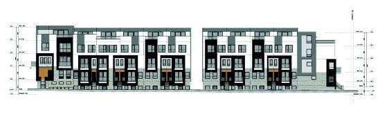
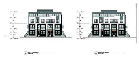
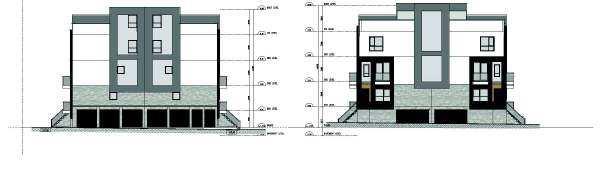
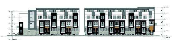
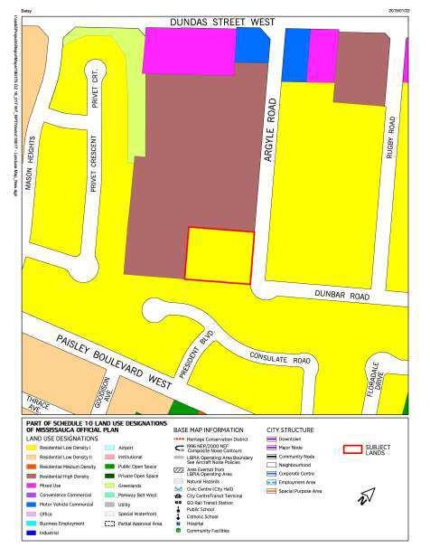
52 Planning and Development Committee 2019/02/15 2 Originator's file: OZ 18/017 W7 Applicant s elevations of the proposed back to back stacked townhomes Comments The property is located on the west side of Argyle Road south of Dundas Street West within the Cooksville Neighbourhood Character Area. The site is currently occupied by 3 detached dwellings.
, Growth Plan for the Golden Horseshoe (Growth Plan) and Region of Peel Official Plan (ROP).")
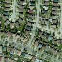
53 Planning and Development Committee 2019/02/15 3 Originator's file: OZ 18/017 W7 Aerial image of 2512, 2522 and 2532 Argyle Road LAND USE POLICIES AND REGULATIONS The relevant policies of Mississauga Official Plan are consistent with the Provincial Policy Statement (PPS), Growth Plan for the Golden Horseshoe (Growth Plan) and Region of Peel Official Plan (ROP). The Greenbelt Plan and Parkway Belt Plan policies do not apply. The proposed development is generally consistent with the PPS and generally conforms to the Growth Plan and the ROP. The conformity of this proposal with the policies of Mississauga Official Plan is under review. Additional information and details are found in Appendix 1, Section 6. AGENCY AND CITY DEPARTMENT COMMENTS Agency and department comments are summarized in Appendix 1, Section 9. Financial Impact All fees paid by developers are strictly governed by legislation, regulation and City by-laws. Fees are required to be paid prior to application approval, except where otherwise may be prescribed. These include those due to the City of Mississauga as well as any other external agency.
54 Planning and Development Committee 2019/02/15 4 Originator's file: OZ 18/017 W7 Conclusion Most agency and City department comments have been received. The Planning and Building Department will make a recommendation on this project after the public meeting has been held and the issues have been resolved. The issues to be addressed include appropriateness of the proposed density, provision of adequate amenity area, landscaping and buffers, and storm sewer capacity. Comments received through community consultation and input will also be addressed prior to making a recommendation. Attachments Appendix 1: Detailed Information and Preliminary Planning Analysis Andrew Whittemore, M.U.R.P., Commissioner of Planning and Building Prepared by: Jonathan Famme, Development Planner
55
56

57
58
59
60
61
62
63
64
65
66
67
68
69
70
71
72
73
74
75
76
77
78
79
80
81
82
83
84
85
86
87 Date: February 8, 2019 To: Chair and Members of Planning and Development Committee From: Andrew Whittemore, M.U.R.P., Commissioner of Planning and Building Originator s file: OZ 18/014 W3 Meeting date: 2019/03/04 Subject PUBLIC MEETING INFORMATION REPORT (WARD 3) Applications to permit two new 8 storey rental apartment buildings consisting of 202 residential units 1485 Williamsport Drive and 3480 Havenwood Drive, northwest corner of Williamsport Drive and Havenwood Drive Owner: Starlight Group Property Holdings Inc. File: OZ 18/014 W3 Bill 139 Recommendation That the report dated February 8, 2019, from the Commissioner of Planning and Building regarding the applications by Starlight Group Property Holdings Inc. to permit two 8 storey rental apartment buildings consisting of 202 residential units, under File OZ 18/014 W3, 1485 Williamsport Drive and 3480 Havenwood Drive, be received for information. Background The applications have been deemed complete and circulated for technical comments. The purpose of this report is to provide preliminary information on the applications and to seek comments from the community. The report consists of two parts, a high level overview of the applications and a detailed information and preliminary planning analysis (Appendix 1). PROPOSAL The official plan amendment and rezoning applications are required to permit two new 8 storey rental apartment buildings consisting of 202 residential units. The two existing buildings will remain. The applicant is proposing to maintain the Residential High Density designation but increase the permitted Floor Space Index (FSI) to 2.1, whereas currently a maximum of 1.2 is permitted. The zoning by-law will also need to be amended from RA2-1 and RA3-1 (Apartments) to RA3-Exception (Apartments) to implement this development proposal.
88 Planning and Development Committee 2019/02/08 2 Applicant s rendering of proposed two 8 storey rental apartment buildings Originator's file: OZ 18/014 W3 During the ongoing review of these applications, staff may recommend different land use designations and zoning categories to implement the proposal. Comments The property is located within the Applewood Neighbourhood Character Area at the northwest corner of Williamsport Drive and Havenwood Drive. The area contains a mix of residential, commercial and community uses. The subject property is currently occupied by two 9 storey rental apartment buildings and a mix of surface and underground parking and landscaping.
, Growth Plan for the Golden Horseshoe (Growth Plan) and Region of Peel Official Plan (ROP).")
89 Planning and Development Committee 2019/02/08 3 Aerial Photo of 1485 Williamsport Drive and 3480 Havenwood Drive Originator's file: OZ 18/014 W3 LAND USE POLICIES AND REGULATIONS The relevant policies of Mississauga Official Plan are consistent with the Provincial Policy Statement (PPS), Growth Plan for the Golden Horseshoe (Growth Plan) and Region of Peel Official Plan (ROP). The Greenbelt Plan and Parkway Belt Plan policies do not apply. The proposed development is generally consistent with the PPS and generally conforms to the Growth Plan and the ROP. The conformity of this proposal with the policies of Mississauga Official Plan is under review. Additional information and details are found in Appendix 1, Section 6. AGENCY AND CITY DEPARTMENT COMMENTS Agency and department comments are summarized in Appendix 1, Section 9. Financial Impact All fees paid by developers are strictly governed by legislation, regulation and City by-laws. Fees are required to be paid prior to application approval, except where otherwise may be prescribed. These include those due to the City of Mississauga as well as any other external agency.
90 Planning and Development Committee 2019/02/08 4 Originator's file: OZ 18/014 W3 Conclusion All agency and City department comments have been received. The Planning and Building Department will make a recommendation on this project after the public meeting has been held and the issues have been resolved. The matters to be addressed include: provision of additional technical information, review of the reduced parking standards, and ensuring compatibility of the new buildings. Attachments Appendix 1: Detailed Information and Preliminary Planning Analysis Andrew Whittemore, M.U.R.P., Commissioner of Planning and Building Prepared by: Tori Stockwell, Development Planner
91
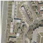
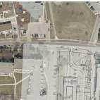
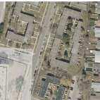
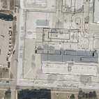
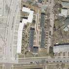
92

93
94
95
96
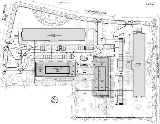
97
98
99
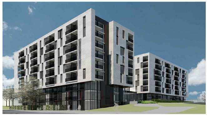
100
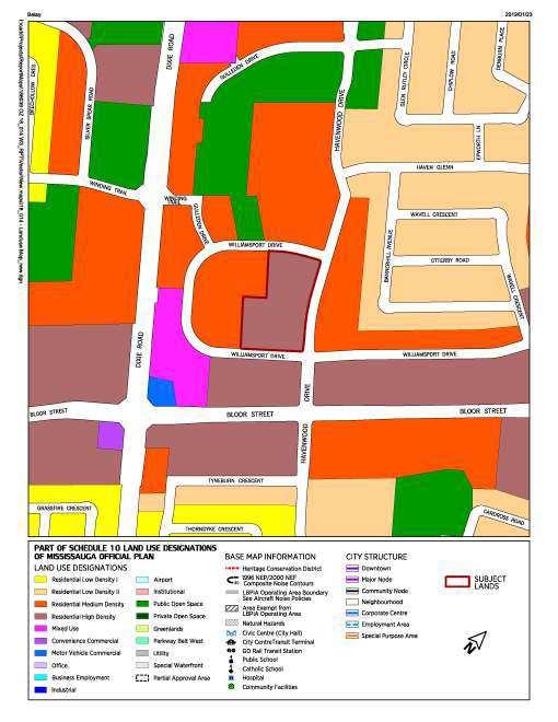
101
102
103
104
105
106
107
108
109
110
111
112
113
114
115
116
117
118
119
120
121
122
123 Date: 2019/02/08 Originator s file: To: Chair and Members of Planning and Development Committee T-M18005 W5 and OZ 18/016 W5 From: Andrew Whittemore, M.U.R.P., Commissioner of Planning and Building Meeting date: 2019/03/04 Subject PUBLIC MEETING INFORMATION REPORT (WARD 5) Applications to permit six condominium apartment buildings with 2,668 units and heights of 28, 33, 35, 40, 40 and 45 storeys, 14 three storey condominium townhomes, 4 three storey common element condominium townhomes, and a public park 91 and 131 Eglinton Avenue East and 5055 Hurontario Street North side of Eglinton Avenue East, East of Hurontario Street Owner: Liberty Development Corporation (91 Eglinton Limited Partnership) File: T-M18005 W5 and OZ 18/016 W5 Bill 139 Recommendation That the report dated January 29, 2019, from the Commissioner of Planning and Building regarding the applications by Liberty Development Corporation to permit six apartment buildings with 2,668 units and heights of 28, 33, 35, 40, 40 and 45 storeys, 14 three storey condominium townhomes, 4 three storey common element condominium townhomes, and a public park, under Files T-M18005 W5 and OZ 18/016 W5, 91 and 131 Eglinton Avenue East and 5055 Hurontario Street, be received for information. Background The applications have been deemed complete and circulated for technical comments. The purpose of this report is to provide preliminary information on the applications and to seek comments from the community. The report consists of two parts, a high level overview of the applications and a detailed information and preliminary planning analysis (Appendix 1). PROPOSAL
124 Planning and Development Committee 2019/02/08 2 Originator's file:t-m18005 W5 and OZ 18/16 W5 Official plan amendment and rezoning applications have been submitted to permit six apartment buildings with 2,668 units and heights of 28, 33, 35, 40, 40 and 45 storeys, 14 three storey condominium townhomes, 4 three storey common element condominium townhomes on abutting lands, a public park, and public and private roads. A draft plan of subdivision has also been submitted to create 8 blocks including one for the park, two for the development and the proposed extension of Thornwood Drive as well as reserves and the widening of Eglinton Avenue East. In order to accommodate this proposal, Mississauga Official Plan (MOP) will require the following changes: Amend Map 13-4 to delete the existing floor space index (FSI) range between Amend Residential High Density Special Site 2 of the Uptown Major Node Character Area to permit building heights in excess of 25 storeys Amend Schedule 10 Land Use Designations from Residential High Density to Public Open Space and Residential Medium Density to permit a public park and townhomes, and from Residential Medium Density to Residential High Density to permit a proposed 28 storey apartment building and townhomes at the southeast quadrant of the site The zoning by-law will also need to be amended from D (Development) to RA5-Exception to permit the condominium apartment buildings and 14 three storey condominium townhomes, RM6-13 to permit the completion of a townhome project on abutting lands with 4 three storey common element condominium (CEC) townhomes and OS1 (Open Space Community Park) to permit a public park. During the ongoing review of these applications, staff may recommend different land use designations and/or provisions and/or zoning categories and regulations to implement this proposal or a modified proposal. Applicant s rendering of the proposed development

125 Planning and Development Committee 2019/02/08 3 Originator's file:t-m18005 W5 and OZ 18/16 W5 Comments The property is located on the north side of Eglinton Avenue East, east of Hurontario Street within the Uptown Node Neighbourhood Character Area. The site is currently occupied by a detached dwelling. The surrounding neighbourhood contains commercial plazas to the west and south across Eglinton Avenue East. There are townhomes, semi-detached and detached homes to the north and townhomes to the east of the site.
, Growth Plan for the Golden Horseshoe (Growth Plan) and Region of Peel")
126 Planning and Development Committee 2019/02/08 4 Aerial image of 91 and 131 Eglinton Avenue East and 5055 Hurontario Street Originator's file:t-m18005 W5 and OZ 18/16 W5 LAND USE POLICIES AND REGULATIONS The relevant policies of Mississauga Official Plan are consistent with the Provincial Policy Statement (PPS), Growth Plan for the Golden Horseshoe (Growth Plan) and Region of Peel Official Plan (ROP). The Greenbelt Plan and Parkway Belt Plan policies do not apply. The conformity of this proposal with the policies of Mississauga Official Plan (MOP) is under review. Additional information and details are found in Appendix 1, Section 5. AGENCY AND CITY DEPARTMENT COMMENTS Agency and department comments are summarized in Appendix 1, Section 8. Financial Impact All fees paid by developers are strictly governed by legislation, regulation and City by-laws. Fees are required to be paid prior to application approval, except where otherwise may be prescribed. These include those due to the City of Mississauga as well as any other external agency.
127 Planning and Development Committee 2019/02/08 5 Originator's file:t-m18005 W5 and OZ 18/16 W5 Conclusion All agency and City department comments have been received. The Planning and Building Department will make a recommendation on this project after the public meeting has been held and the issues addressed. Major issues include: Confirmation of the adequacy of the existing sewer and waste services Impacts on traffic Confirmation of the street network including the Belbin Street extension Ensuring appropriate transition in heights Provision of affordable housing Mix of uses on the site including addressing the provincial policies requiring that people and jobs be provided on site NAV Canada clearance regarding potential impact on the runway approach procedures Location of the proposed park and/or the shadow impacts of the proposed apartment buildings on the park Attachments Appendix 1: Detailed Information and Preliminary Planning Analysis Andrew Whittemore, M.U.R.P., Commissioner of Planning and Building Prepared by: Caleigh McInnes, Development Planner
128 Appendix 1, Page 1 File: OZ 18/016 W5 and T-M18005 W5 Detailed Information and Preliminary Planning Analysis Owner: Liberty Development Corporation Table of Contents 1. Site History Site and Neighbourhood Context... 2 Other Development Applications... 4 Community Services Project Details... 5 Concept Plan and Elevations Community Comments Land Use Policies and Regulations...11 Excerpt of Uptown Major Node Land Use...11 Existing Zoning and General Context...12 Proposed Zoning and General Context...12 Summary of Applicable Policies...13 Existing and Proposed Mississauga Official Plan Designation for the Subject Site...14 Existing Designations...14 Proposed Designations...15 Provincial Policy Statement (PPS) and Growth Plan Analysis...15 Consistency with Provincial Policy Statement Conformity with Growth Plan Region of Peel Official Plan...25 Relevant Mississauga Official Plan Policies...25 Existing and Proposed Zoning Section 37 Community Benefits (Bonus Zoning) School Accommodation Development Issues...32 Development Requirements...35 Other Information...35
129 Appendix 1, Page 2 File: OZ 18/016 W5 and T-M18005 W5 1. Site History There is one detached dwelling located on the subject property The lands were historically used as an orchard. Two single-storey storage barns, a two storey barn and a wood shed were present 1975 A detached home was built on the property March 5, 2003 The Region of Peel approved the Mississauga Plan policies for the Hurontario District, designating the subject lands as Residential Medium Density I and Residential High Density II June 20, 2007 Zoning By-law came into force except for those sites which were appealed. The subject lands were zoned D (Development) which only permits legally existing uses December 12, 2012 City Council enacted By-law to amend Mississauga Official Plan (MOPA 3) from Residential Medium Density I and Residential High Density II to Residential High Density: Special Site 2 and Residential Medium Density 2. Site and Neighbourhood Context The property is located on the north side of Eglinton Avenue East, east of Hurontario Street, within the Uptown Major Node Character Area. The site is currently occupied by a detached home. The Uptown Major Node is centred on the Hurontario Street and Eglinton Avenue intersection and is undergoing significant transition and growth. A future Light Rail Transit (LRT) stop is proposed at the intersection of Hurontario Street and Eglinton Avenue East, west of the subject property. Land uses within the node consist of apartment buildings, retail and office commercial, and some vacant parcels. Generally, there is a transition from high density development to medium and low density residential buildings further from the Hurontario/Eglinton intersection. The population of this Major Node is forecast to more than double between 2011 (9,465) and 2041 (19,700), with a population density of people/ha. Seventy percent of the population within this area are working age (15 to 64 years of age), 17% are children (0-14 years) and 13% are seniors (65 years and over). There are slightly fewer children and more seniors living in the Uptown Major Node Character Area when compared to the City as a whole. On average, the total number of persons within a household in this area is 2. Approximately 87% of the population living in apartments of five storeys or higher, which is significantly greater than the City s average (25%). The mix of housing tenure for the node is 2,665 units (67%) owned and 1,290 units (33%) rented, with a vacancy rate of approximately 0.8%. The node contains the Emerald Centre (west side of Hurontario Street, south of Eglinton Avenue West), Cityside Shopping Centre (northeast corner of Hurontario Street and Eglinton
130 Appendix 1, Page 3 File: OZ 18/016 W5 and T-M18005 W5 Avenue East), Mississauga Marketplace Plaza (southeast corner of Hurontario Street and Eglinton Avenue East) and 30 Eglinton West Commercial Centre (southwest corner of Hurontario Street and Eglinton Avenue West). These plazas provide a range of services including a grocery store, drug store, medical offices, gym, Service Ontario, and restaurants. The Frank McKechnie Community Centre and Library are located on Bristol Road East, east of Hurontario Street, approximately 1.5 km (0.93 miles) northeast of the site. There are several Miway bus routes (19, 19A, 19B, 19C, and 103) that provide access directly to the Downtown Transit Terminal, which connect to the Cooksville GO Station and to the Transit Way. There are also bus routes on Eglinton Avenue (35 and 35A) which provide access to the Islington (TTC) Station. Aerial Photo Property Size and Use Frontages: 5055 Hurontario Street 91 Eglinton Avenue East 131 Eglinton Avenue East Depth: Total Gross Lot Area: Existing Uses: 120 m (394 ft.) via Armdale Road 223 m (732 ft.) 27 m (89 ft.) 183 m (600.4 ft.) 4.83 ha (11.93 ac.) One storey detached home

131 Appendix 1, Page 4 File: OZ 18/016 W5 and T-M18005 W5 The surrounding land uses are: North: Three and three and a half storey townhomes and vacant lands zoned for three apartment buildings with maximum heights of 21, 27 and 30 storeys East: Three storey townhomes and a 20 storey apartment building South: A commercial plaza across Eglinton Avenue East and vacant lands zoned for apartments with maximum heights of 20 and 25 storeys. The plaza contains restaurants, banks, and a grocery store (Oceans) West: A commercial plaza containing restaurants and a variety of shops Image of existing conditions looking northeast from across Eglinton Avenue East Other Development Applications There is an active site plan for two apartment buildings with heights of 15 and 34 storeys on the north side of Watergarden Drive, directly east of Four Springs Avenue. There are also active development applications for five apartment buildings containing 2,095 units with heights of 30, 35, 38, 50 and 50 storeys on the west side of Hurontario, north and south of Watergarden Drive. There is a 33 storey apartment building (under construction), at the southeast corner of Hurontario Street and Nahani Way.
132 Appendix 1, Page 5 File: OZ 18/016 W5 and T-M18005 W5 Community Services Sandalwood Park is located on the north side of Nahani Way, east of Thornwood Drive, which is less than 378 m (1,240 ft.) from the subject lands. There is also a proposed park on the west side of Hurontario along Cooksville Creek. Given the limited number of parks within the immediate area and the proposed density and units being requested, Community Services has requested a park on the subject lands to serve this development and immediate area. Nahani Way Public School is located on the north side of Nahani Way, east of Thornwood Drive. Bristol Road Middle School is located on the south side of Bristol Road East, east of Hurontario Street, and Applewood Heights Secondary School is located on the north side of Bloor Street west of Tomken Road. 3. Project Details The existing Uptown Major Node official plan policies require a minimum floor space index (FSI) of 1.9 and a maximum of 2.9 on the portion of the subject lands located west of the proposed Thornwood Drive extension. An FSI of 2.9 would allow almost three times the amount of building gross floor area as compared to the size of the lot. The applications are to permit six apartment buildings containing 2,668 units with heights of 28, 33, 35, 40, 40 and 45 storeys and permissive zoning to allow the ground floor to be converted to office and retail commercial uses. They are proposing fourteen three storey condominium townhomes and 4 three storey common element condominium townhomes to align with those on abutting lands to the north. A public park is also proposed on the subject property. A maximum floor space index (FSI) of 5.96 is proposed. Development Proposal Applications Received: October 5, 2018 submitted: Deemed complete: October 12, 2018 Developer/ Liberty Development Corporation Owner/Applicant: Number of units: 2,668 Proposed Residential Gross m 2 (2,278,798 sq.ft.) Floor Area: Proposed Non-Residential 0 m 2 (0 sq.ft.) The applicant is requesting that the Gross Floor Area: proposed zoning by-law include provisions to allow for the conversion of ground floor space to commercial use in the future. Total Gross Floor Area (GFA) m 2 (2,278,798 sq.ft.) Height: 28, 33, 35, 40, 40 and 45 storeys Lot Coverage: 45.28% Floor Space Index: 5.96 Landscaped Area: 37.83% Net Density: Anticipated Population: Parking: resident spaces visitor spaces 1,212 people/ha 5,855 people* *Average household sizes for all units (by type) based on the 2016 Census Required 3, Proposed 2,

133 Appendix 1, Page 6 File: OZ 18/016 W5 and T-M18005 W5 Development Proposal commercial spaces total Green Initiatives: 0 0 4,065 2,892 Rainwater harvesting Green roofs Enhanced grass swale and bioretention Permeable pavement Enhanced topsoil Soft landscaping and pedestrian comfort strategies Concept Plan and Elevations Site Plan 35 storeys Public Park 3 storeys 40 storeys 33 storeys 3 storeys 45 storeys 40 storeys 28 storeys


134 Appendix 1, Page 7 File: OZ 18/016 W5 and T-M18005 W5 Elevations North and East Elevations (Right to Left) Proposed Buildings A and B South Elevation Proposed Buildings A, B and C

135 Appendix 1, Page 8 File: OZ 18/016 W5 and T-M18005 W5 West Elevation Proposed Buildings F, E and A


136 Appendix 1, Page 9 File: OZ 18/016 W5 and T-M18005 W5 North, East and West Elevations (Top Right to Bottom Left) East and West Elevations Proposed Building G (Right to Left)
137 Appendix 1, Page 10 File: OZ 18/016 W5 and T-M18005 W5 Applicant's rendering 4. Community Comments The following comments received through letters and s from the community as well as any other issues raised at the public meeting will be addressed in the Recommendation Report, which will come at a later date. Concern with proposed height and density Additional traffic generated by the development will further impact the entire neighbourhood and, in particular, the intersection of Hurontario Street and Eglinton Avenue Concern with air pollution and noise from increased traffic Concern over loss of view and shadow impacts as a result of the proposed buildings No community meetings have been held.

138 Appendix 1, Page 11 File: OZ 18/016 W5 and T-M18005 W5 5. Land Use Policies and Regulations Excerpt of Uptown Major Node Land Use
139 Appendix 1, Page 12 File: OZ 18/016 W5 and T-M18005 W5 Existing Zoning and General Context Proposed Zoning and General Context
140 Appendix 1, Page 13 File: OZ 18/016 W5 and T-M18005 W5 Summary of Applicable Policies The following table summarizes the applicable policy and regulation documents that affect these applications: Policy Provincial Policy Statement (PPS) Growth Plan for the Greater Golden Horseshoe (Growth Plan) Mississauga Official Plan (MOP) Policies The existing policies of MOP are consistent with the PPS The existing policies of MOP conform with the Growth Plan Proposal The proposed development is being reviewed for consistency with the PPS. The proposed development is being reviewed for conformity with the Growth Plan. Greenbelt Plan n/a n/a Parkway Belt Plan n/a n/a Region of Peel Official Plan The existing policies of MOP are consistent with the ROP The proposed application is exempt from Regional approval Mississauga Official Plan The lands are located within the Uptown Major Node Character Area and are designated Residential High Density Special Site 2 which permits apartment dwellings and a floor space index of between 1.9 and 2.9 and Residential Medium Density which permits low rise apartment buildings, and all forms of townhouse dwellings. Major Node policies are intended to ensure they develop as a prominent centre with a regional and city focus, and will be served by higher order transit. Major Nodes will provide a mix of uses including employment, commercial, residential, educational and open space. It is also anticipated that Major Nodes will provide a variety of higher density housing for people in different phases of their lifecycle and for a variety of income groups. Major Nodes will be developed to support and encourage active transportation as a mode of transportation. Official plan amendment and rezoning applications are required to permit six apartment buildings with 2,668 units and heights of 28, 33, 35, 40, 40, and 45 storeys, 14 three storey condominium townhomes, 4 three storey common element condominium townhomes on abutting lands, and a public park all on public and private roads with a maximum FSI of In order to accommodate this proposal, Mississauga Official Plan (MOP) will require the following changes: Amend Map 13-3 to delete the existing floor space index (FSI) of 1.9 to 2.9 Amend Residential High Density Special Site 2 of the Uptown Major Node Character Area to permit building heights in excess of 25 storeys and townhomes Amend Schedule 10 Land Use Designations from Residential High Density to Public Open Space and Residential Medium Density to permit a public park and townhomes from Residential Medium Density to Residential High Density to permit a 28 storey apartment

141 Appendix 1, Page 14 File: OZ 18/016 W5 and T-M18005 W5 Policy Zoning By-law Mississauga Official Plan (MOP) Policies The lands are currently zoned D (Development) Proposal building at the southeast quadrant of the site These designations are consistent with the intent of the official plan but will need to address transitions, the City Structure hierarchy, as well as servicing and built form policies, as outlined in the Development Issues section below. The applicant is proposing to change the existing zoning to RA5- Exception (Apartments), RM6-13 (Common Element Condominium Townhomes) and OS1 (Community Park). Existing and Proposed Mississauga Official Plan Designation for the Subject Site Existing Designations Residential High Density Special Site 2 permits apartment buildings. Notwithstanding the provisions of MOP, the following additional policy also applies: a. A concept plan will be required to address, among other matters: compatibility of building form and scale with existing and proposed surrounding land uses; and acceptable ingress and egress arrangements for Hurontario Street, Eglinton Avenue East, and Thornwood Drive
142 Appendix 1, Page 15 File: OZ 18/016 W5 and T-M18005 W5 Notwithstanding the provision of the Residential High Density designation, the subject lands will be permitted to develop to a maximum floor space index (FSI) of between 1.9 and 2.9 Residential Medium Density includes and permits all forms of townhouse dwellings. Major Node policy indicates that Notwithstanding the Residential Medium Density policies of this Plan, low-rise apartment dwellings will be permitted. Uptown Major Node policy indicates that for lands designated Residential Medium Density, building heights will not exceed three storeys. Proposed Designations Residential High Density Special Site 2 permits apartment buildings, however, the following additional policies will apply: a. A concept plan will be required to address, among other matters: compatibility of building form and scale with existing and proposed surrounding land uses; and acceptable ingress and egress arrangements for Hurontario Street, Eglinton Avenue East, and Thornwood Drive b. Notwithstanding the provision of the Residential High Density designation, the Special Site 2 lands identified as Areas 2D will be permitted to develop to a maximum floor space index (FSI) of 5.96 c. Townhomes will be permitted Residential Medium Density to permit townhomes. Public Open Space to permit a community park. Provincial Policy Statement (PPS) and Growth Plan Analysis Consistency with Provincial Policy Statement 2014 The Provincial Policy Statement 2014 (PPS) is issued under Section 3 of the Planning Act and all decisions affecting land use planning matters "shall be consistent" with the Provincial Policy Statement. The following table has been prepared to demonstrate how MOP policies are consistent with the relevant PPS policies (i.e. "Mississauga Official Plan Policies" column). In addition, the table provides a preliminary assessment as to how the proposed development is consistent with PPS and MOP policies (i.e. "OZ 18/016 W5 Consistency" column). Only key policies relevant to the application have been included, and the table should be considered a general summary of the intent of the policies. Official Plan Amendment No. 47 to MOP added and amended policies in the Official Plan so that it is consistent with the PPS. This amendment came into force on May 18, Consistency Analysis Provincial Policy Mississauga Official Plan Statement (PPS) Policies (MOP) 1.0 Building Strong Healthy Communities General Statement of MOP provides for efficient Intent: land use patterns by OZ 18/016 W5 Consistency The proposed redevelopment represents a significant
143 Appendix 1, Page 16 File: OZ 18/016 W5 and T-M18005 W5 Provincial Policy Statement (PPS) Promoting efficient land use and development patterns are important to sustainable, liveable, healthy, resilient communities, protecting the environment, public health and safety and facilitating economic growth Land use patterns within settlement areas shall be based on: a) Densities and a mix of land uses which: 1. efficiently use land and resources 2. are appropriate for and efficiently use infrastructure and public service facilities 3. minimize negative impacts to air quality and climate change and promote energy efficiency 4. support active transportation 5. are transit supportive b) A range of uses and opportunities for intensification and redevelopment in accordance with criteria in Planning authorities shall identify appropriate locations for intensification and redevelopment where it can be accommodated taking into account building stock, brownfields, availability of infrastructure and public service facilities required to accommodate Mississauga Official Plan Policies (MOP) recognizing that development and intensification will occur; however, the magnitude will vary in accordance with the City s urban hierarchy. (5.3 City Structure). The Uptown Major Node is identified as a Major Node which is an element in the City s urban structure that is intended for intensification and provides a mix of uses (as identified on Schedule 10 Land Uses of MOP) and allows for higher density housing). As described in policy 5.3.2, Major Nodes among other things are intended to: Be a prominent centre with a regional and city focus Provide access to a mix of uses including employment, commercial, residential, educational and open space and a variety of higher density housing for people in different phases of their lifecycle and for a variety of income groups Achieve a targeted gross density of between 200 and 300 residents plus jobs per hectare. The Uptown Major Node is an area intended for intensification (MOP policy 5.3.2). The proposed development can utilize surrounding community infrastructure (library, schools and places of religious assembly) and has access to adequate servicing (water, OZ 18/016 W5 Consistency intensification. As part of the next staff report, the applications will be assessed with regard to whether the proposed built form appropriately addresses the City Structure. The proposed development intensifies the use of the land and resources, infrastructure and public service facilities; it supports active transportation and is transit supportive. An evaluation of the mix of jobs and people will be provided in the recommendation report. The extent to which growth should be accommodated on the subject site, and the built form of the development is subject to further review and will be included in the next staff report. The proposed development responds to intensification policies. Careful attention, however, is required to confirm appropriate scale and transitions to adjacent land uses, as well as the overall capacity of the Uptown Major Node. These issues will be discussed in the next staff report.
144 Appendix 1, Page 17 File: OZ 18/016 W5 and T-M18005 W5 Provincial Policy Statement (PPS) projected needs. Mississauga Official Plan Policies (MOP) sanitary and storm facilities). Policies in MOP ensure intensification is in accordance with the wise management of resource and protecting health and safety. OZ 18/016 W5 Consistency Appropriate development standards should facilitate intensification, redevelopment and compact form, while mitigating risks to public health and safety. 1.4 Housing Planning Authorities shall provide for an appropriate range and mix of housing that is affordable The Built Form policies of MOP (MOP policies contained in section 9) provide direction on appropriate standards to facilitate intensification with respect to transition, sun/shadow impacts, compact urban form and public realm. The proposed development provides significant intensification within the Major Node and is being evaluated with respect to providing appropriate transitions to the surrounding properties. MOP includes policies that require development applications to provide appropriate height and built form transitions between sites and their surrounding area ( ). Major Nodes are intended to provide a variety of higher density housing for people in different phases of their lifecycle and for a variety of income groups (5.3.2) 4.0 Implementation and Interpretation General Statement of As outlined in this table, the Intent: policies of Mississauga Provides direction on how Official Plan are generally the Provincial Policy consistent with the relevant Statement is to be policies of the Provincial implemented and Policy Statement. interpreted. 4.2 Decisions of the council The proposed development responds to intensification policies. The proposed transitions to adjacent properties are being evaluated. These issues will be discussed in the subsequent staff report. Additional information is required to determine if the proposed development improves the range and variety of housing in the City. The applicant has not yet indicated the amount of affordable housing proposed. These applications are generally supportive of a number of PPS and MOP policies. The applications are also being further evaluated with respect to MOP policies concerning traffic, servicing capacity, height and transition to surrounding land
145 Appendix 1, Page 18 File: OZ 18/016 W5 and T-M18005 W5 Provincial Policy Statement (PPS) of a municipality shall be consistent with the Provincial Policy Statement 4.7 The Official Plan is the most important vehicle for implementation of the Provincial Policy Statement Mississauga Official Plan Policies (MOP) OZ 18/016 W5 Consistency uses. Conformity with Growth Plan 2017 The Growth Plan for the Greater Golden Horseshoe (Growth Plan) (2017) was issued under Section 7 of the Places to Grow Act and all decisions affecting lands within this area will conform with this Plan. The following table has been prepared to demonstrate how MOP policies conform with the relevant Growth Plan policies (i.e. "Mississauga Official Plan Policies" column). In addition, the table provides a preliminary assessment as to how the proposed development conforms with Growth Plan and MOP policies ("OZ 18/016 W5 Conformity" column). Only key policies relevant to the application(s) have been included, and that table should be considered a general summary of the intent of the policies. MOP was prepared and approved in accordance with the Growth Plan Mississauga is in the process of reviewing MOP policies to ensure conformity with the new Growth Plan The development application has been reviewed against Growth Plan 2017 policy direction to ensure conformity. Conformity Analysis Growth Plan for the Greater Golden Horseshoe Mississauga Official Plan Policies (MOP) 1.1 The Greater Golden Horseshoe General Statement of The policies of MOP will Intent: accommodate growth within The Greater Golden the existing urban boundary, Horseshoe plays an helping to reduce sprawl. important role in The policies provide a accommodating growth, planning framework to however, the magnitude of address the challenges of anticipated growth will accommodating growth. present challenges to infrastructure, congestion, Section 4 of MOP outlines the sprawl, healthy City s Vision, and Guiding communities, climate Principles which will help change and healthy shape change that the environment Growth Plan anticipates. OZ 18/016 W5 Conformity The development applications represent growth within the existing urban boundary. Any potential issues associated with accommodating additional growth on the subject site will be further evaluated based on relevant policies and guidelines.
146 Appendix 1, Page 19 File: OZ 18/016 W5 and T-M18005 W5 Growth Plan for the Greater Golden Horseshoe Mississauga Official Plan Policies (MOP) OZ 18/016 W5 Conformity 1.2 The Growth Plan for the Greater Golden Horseshoe General Statement of The Vision for Mississauga is Intent: that it will be a beautiful The Vision for the Greater sustainable city that protects Golden Horseshoe is that it its natural and cultural will be a great place to live, heritage resources and its supported by a strong established stable economy, a clean and neighbourhoods (MOP healthy environment, and section 4). social equity, with an extraordinary waterfront. The City is planning for a strong economy supported by a range of mobility options and a variety housing and community infrastructure to create distinct, complete communities. MOP directs growth to areas that support existing and planned transit facilities and other infrastructure improvements (MOP Section 4.5). The site location on Eglinton Avenue East, approximately 130 m (426.5 ft.) from Hurontario Street is supportive of existing and future public transit (LRT). The appropriateness of the built form as it relates to implementing the Vision is being further evaluated Guiding Principles General Statement of Intent for this Section: The policies of this Plan are based on the following principles: a. Complete communities b. Prioritize intensification c. Provide flexibility to capitalize on new employment The intent is to further develop the Uptown Major Node as a prominent centre with a regional and city focus, by serving it with higher order transit, providing access to a mix of uses, and by promoting an urban form and development that supports and encourages active transportation. MOP policies include but are not limited to: a. Providing for a mix of uses including employment, commercial, residential, educational and open space. b. Identifying the area as a Major Node which is intended to The development applications are supportive of many Growth Plan principles; however, the manner in which the applications implement those principles will be evaluated against official plan policies and city guidelines. The mix of uses and housing affordability will need further review through the processing of this application.
147 Appendix 1, Page 20 File: OZ 18/016 W5 and T-M18005 W5 Growth Plan for the Greater Golden Horseshoe opportunities d. Support a range and mix of housing options e. Integrate land use planning and investment in infrastructure f. Provide different approaches to manage growth that recognize diversity of communities g. Protect natural heritage, hydrologic, landforms h. Conserve and promote cultural heritage i. Integrate climate change considerations Mississauga Official Plan Policies (MOP) accommodate intensification with a gross density of between 200 and 300 residents plus jobs (MOP Section 5.3.2); c. Providing for a variety of higher density housing for people in different phases of their lifecycle and for a variety of income groups. d. Ensuring that development in Major Nodes will be in a form and density that achieves a high quality urban environment. OZ 18/016 W5 Conformity Legislative Authority General Statement of Intent: All decisions made on or after July 1, 2017 will conform with this Plan How to Read this Plan General Statement of Intent for this Section: Outlines the relationship between the Growth Plan and other planning documents, and how to read the plan 2. Where and How to Grow 2.1 Context General Statement of Intent: This Plan is about building compact and complete communities. Better use of land and infrastructure can be made by prioritizing intensification, building compact and complete As illustrated through this table, MOP generally conforms to the Growth Plan, as it pertains to the proposed development. Relevant MOP policies have been reviewed in respect of the Growth Plan and other planning documents. The MOP policies conform with the general intent, as summarized in the Vision and Guiding Principle section of the document (Section 4). As the decision on the applications will occur after July 1, 2017, the application must conform to the Growth Plan MOP has been reviewed in respect to the Growth Plan and other applicable Provincial planning documents. The Uptown Major Node is planned as a complete community and identified as a Major Node which is an area for intensification that provides for a mix of uses including employment, commercial, residential, educational and open space. This node is situated on
148 Appendix 1, Page 21 File: OZ 18/016 W5 and T-M18005 W5 Growth Plan for the Greater Golden Horseshoe communities, and increasing the modal share for transit and active transportation. Mississauga Official Plan Policies (MOP) OZ 18/016 W5 Conformity existing transit routes, as well as the future LRT, and is in proximity to existing community infrastructure (schools, parks, libraries, community centres, emergency services and places of religious assembly. 2.2 Policies For Where and How To Grow Managing Growth General Statement of The Uptown Major Node is Intent for this Section: designated as an area for Growth will be primarily intensification to be a directed to appropriate prominent centre with a locations that support regional and city focus. This complete communities and will include a variety of higher infrastructure, as directed density housing, employment, by the upper tier commercial, residential, municipality. educational and open space. Relevant Policies: a. Growth should be primarily directed to settlement areas that: i. Are within the built boundary and have planned municipal water and wastewater systems and support complete communities ( a i, ii, iii) ii. that are in delineated built-up areas, strategic growth areas, locations with existing or planned transit and public service facilities ( c i, ii, iii, iv), iii. that is generally away from hazardous lands ( e) b. Integrated planning to a. The Uptown Major Node is an appropriate location for growth as it is within the delineated boundary of a settlement area, with access to municipal water and wastewater, and is planned to provide a range of land uses to support a complete community. b. MOP ensures forecasted growth is properly managed as development may be phased if satisfactory arrangements for infrastructure are not made. The Node includes a mix of land uses and housing types. MOP includes polies to ensure high quality compact built form, attractive public realm, including open spaces, through site design and urban The next step in the planning process is to determine whether the development applications are accommodating growth in a built form that appropriately responds to the existing and planned character for the area. The proposed development will be evaluated against the applicable MOP policies. Given the number of development applications in the Uptown Major Node, staff have undertaken a limited capacity study to determine if there is sufficient infrastructure to accommodate the growth that is being proposed. The proposed development will be evaluated against the applicable MOP policies.
149 Appendix 1, Page 22 File: OZ 18/016 W5 and T-M18005 W5 Growth Plan for the Greater Golden Horseshoe manage forecasted growth will: i. Be supported by planning for infrastructure and public service facilities that consider the full life cycle cost and payment ( b) ii. Provide direction for an urban form that will optimize infrastructure ( c) iii. Support the environment ( d) iv. Be implemented through a municipal comprehensive review ( e) c. The Growth Plan will support the achievement of complete communities that i. Features a diverse mix of land uses ii. Improves social equity iii. Provides mix of housing options iv. Expands convenient access to transportation, public service facilities, open space, healthy food options v. Ensures high quality compact built form, attractive public realm, including open spaces, through site design and urban design vi. Mitigates climate Mississauga Official Plan Policies (MOP) design (MOP section 9.1). Developing vacant and underutilized lots appropriately and providing for a variety of higher density housing will help to establish the Node as a prominent centre. OZ 18/016 W5 Conformity
150 Appendix 1, Page 23 File: OZ 18/016 W5 and T-M18005 W5 Growth Plan for the Greater Golden Horseshoe change vii. Integrates green infrastructure Delineated Built-up Areas Statement of Intent: The majority of growth is directed to lands within the delineated built-up area (i.e. limits of the developed urban area identified by the Minister of Municipal Affairs and Housing). Mississauga Official Plan Policies (MOP) Transit Corridors and Station Areas Statement of Intent: Given Provincial investment in higher order transit municipalities are to plan for "major transit station areas on priority transit corridors" as identified on Schedule 5 of the Growth Plan ( ) Employment General Statement of Intent for this Section: It is important to ensure an adequate supply of employment land Housing General Statement of Intent: A range and mix of housing is to be provided, including affordable housing. A housing strategy prepared by the Region is an important tool that can be used. The Uptown Major Node is located within the delineated built-up area and will assist in achieving intensification targets. Hurontario Street is identified in the Growth Plan as a transit priority corridor. MOP identifies Hurontario Street as an intensification / higher order transit corridor. The site is also located within a Major Transit Station Area. MOP policies support intensification that is appropriate for the location. Intensification Areas (e.g. corridors and station areas) will be planned to reflect their role in the City Structure hierarchy (5.5.4). The Major Node policies encourage a variety of uses including employment, commercial, residential, educational and open space. Mississauga Council has recently approved a citywide affordable housing strategy that is currently being implemented. The strategy can be accessed at: ocuments/pb/planreports/201 7/Affordable_Housing_Strate gy_appendix1&2-web.pdf OZ 18/016 W5 Conformity The development applications are supportive of the Growth Plan intent to direct development within the built-up area. However, the manner in which growth is accommodated on the site is subject to further review. The development applications are supportive of policies that direct development to intensification areas that are transit supportive. The applications propose to include zoning provisions that will allow for the conversion of ground floor space to office and retail commercial uses. The Region of Peel and the City of Mississauga are working together to address housing issues. A diverse range of housing options is encouraged by MOP (Section 7.2.2). Through the next step in the planning process, staff will assess whether the proposed applications contribute to the
151 Appendix 1, Page 24 File: OZ 18/016 W5 and T-M18005 W5 Growth Plan for the Greater Golden Horseshoe Relevant Policies: a. The Region is responsible for preparing a housing strategy ( ) b. Municipalities will support complete communities by accommodating growth forecasts, achieve minimum intensification targets, consider a range of housing options, and planning to diversify the housing stock. ( ) 5 Implementation Statement of Intent: Comprehensive municipal implementation is required to implement the Growth Plan. Where a municipality must decide on planning matters before its official plan has been updated it must still consider impact of decision as it relates to the policy of the plan. The policies of this section address implementation matters such as: how to interpret the plan, supplementary direction on how the Province will implement, co-ordination of the implementation, use of growth forecasts and targets, performance indicators and monitoring, interpretation of schedules and appendices. Mississauga Official Plan Policies (MOP) MOP policies provide opportunities for a range of housing choices, a variety of affordable dwellings, and production of housing for those with special needs such as the elderly (Section 7.2.2). MOP must conform with a hierarchy of policy and legislation at the federal, provincial, regional, and municipal level. In particular provincial policy initiatives provide strong direction for the growth management and development strategies found in MOP. OZ 18/016 W5 Conformity range of housing options and affordable housing in the City. The Region of Peel and the City of Mississauga are working together to address affordable housing issues. Through the next step in the planning process, staff will assess whether the proposed applications contribute to affordable housing in the City. Not directly applicable, as these policies speak to interpretation and how to read the plan and are contained in Section 1.0 of the Mississauga Official Plan.
152 Appendix 1, Page 25 File: OZ 18/016 W5 and T-M18005 W5 Region of Peel Official Plan The Region of Peel approved MOP on September 22, The proposed development applications were circulated to the Region who has advised that in its current state, the applications meet the requirements for exemption from Regional approval. Local official plan amendments are generally exempt from approval where they have had regard for the Provincial Policy Statement and applicable Provincial Plans, where the City Clerk has certified that processing was completed in accordance with the Planning Act and where the Region has advised that no Regional official plan amendment is required to accommodate the local official plan amendment. The Region provided additional comments which are discussed in Section 9 of this report. Relevant Mississauga Official Plan Policies There are other policies in Mississauga Official Plan (MOP) that are also applicable in the review of these applications, some of which are found below. Section 4 Vision Section 5 Direct Growth Section 5 Direct Growth- Major Nodes Specific Policies Section Section Section 4.5 Section Section Section Section 5.3 Section General Intent Mississauga will provide the guiding principles that are to assist in implementing the long-term land use, growth and development plan for Mississauga and sets out how the City will achieve these guiding principles. Most of Mississauga s future growth will be directed to Intensification Areas. Mississauga encourages compact, mixed use development that is transit supportive, in appropriate locations, to provide a range of live/work opportunities. New development will not exceed the capacity of existing and planned engineering services, transit services and community infrastructure. Development proposals may be refused if existing or planned servicing and/or infrastructure are inadequate to support the additional population and employment growth that would be generated or be phased to coordinate with the provision of services and infrastructure. MOP will ensure that Major Nodes develop as prominent centres with regional and city focus, and will be served by higher order transit. Major Nodes will provide a mix of uses including employment, commercial, residential, educational and open space. It is also anticipated that Major Nodes will provide a variety of higher density housing for people in different phases of their lifecycle and for a variety of income groups. Major Nodes will achieve a gross density of between 200 and 300 residents and jobs per hectare (81 and 121 residents and jobs combined per acre), and an average employment ratio of between 2:1 to 1:2, measured as an average across the entire area of each node.
153 Appendix 1, Page 26 File: OZ 18/016 W5 and T-M18005 W5 Section 5 Direct Growth- Corridors Specific Policies Section Section Section Section Section Section Section Section Section Section General Intent Development applications within a Major Node proposing a change to the designated land use which results in a significant reduction in the number of residents or jobs that could be accommodated on the site will not be permitted unless considered through a municipal comprehensive review. Major Nodes will be developed to support and encourage active transportation as a mode of transportation. Corridors connect various elements of the city to each other. Over time, many of these Corridors will evolve and accommodate multi-modal transportation and become attractive public spaces in their own right. Some Corridors have been identified as appropriate locations for intensification. A corridor is generally comprised of the road right-of-way as well as the lands on either side of the road. Development on Corridors should be compact, mixed use and transit friendly and appropriate to the context of the surrounding Neighbourhood.
154 Appendix 1, Page 27 File: OZ 18/016 W5 and T-M18005 W5 Section 7 Complete Communities Section 8 Create a Multi- Modal City Section 9 Building a Desirable Urban Form Section Section Section Section 7.2 Housing Section Section Section Section Section 8.1 Section 8.2 Section Section Section Section 8.3 Section Section Section 9.1 Section Section Section Section Section Section Section Section 9.3 The official plan supports the creation of complete communities that meet the day-to-day needs of people through all stages of their life offering a wide assortment of housing options and employment opportunities as well as numerous commercial and social venues. The provision of suitable housing is important to ensure that youth, older adults and immigrants thrive. Mississauga will ensure that housing is provided in a manner that maximizes the use of community infrastructure and engineering services, while meeting the housing needs and preferences of Mississauga residents. Mississauga will provide opportunities for: a. The development of a range of housing choices in terms of type, tenure and price: b. The production of a variety of affordable dwelling types for both the ownership and rental markets; and, c. The production of housing for those with special needs, such as housing for the elderly and shelters. Design solutions that support housing affordability while maintaining appropriate functional and aesthetic quality will be encouraged. The provision of housing that meets the needs of young adults, older adults and families will be encouraged in the Downtown, Major Nodes and Community Nodes. Housing is to be provided in a manner that maximizes the use of community infrastructure and engineering services, while meeting the housing needs and preferences of Mississauga residents. A range of housing types, tenure and price is to be provided. Mississauga will strive to create a fine-grained system of roads to increase the number of road intersections and overall connectivity throughout the City. Future additions to the road network should be public roads. Public easements may be required where private roads are permitted. Within Intensification Areas an urban form that promotes a diverse mix of uses and supports transit and active transportation modes will be required. Appropriate infill in both Intensification Areas and Non- Intensification Areas will help to revitalize existing communities by replacing aged buildings, developing vacant or underutilized lots and by adding to the variety of building forms and tenures. It is important that infill "fits" within the existing urban context
155 Appendix 1, Page 28 File: OZ 18/016 W5 and T-M18005 W5 Section Section 9.4 Section 9.5 and minimizes undue impacts on adjacent properties. Residential developments of a significant size, except for freehold developments, will be required to provide common outdoor on-site amenity areas that are suitable for the intended users. Section 9 Intensification Areas Section 9 Site Development Buildings Section 13 Major Nodes Section Section Section Section Section Section Section Section Section Section Section Section Section Section Section through to Section Various Sections Section 13.1 Section 13.4 Buildings and site design will be compatible with site conditions, the surrounding context and surrounding landscape of the existing or planned character of the area. Developments will provide a transition in building height and form between Intensification Areas and adjacent Neighbourhoods with lower density and heights. Development proposals will demonstrate compatibility and integration with surrounding land uses and the public realm by ensuring that adequate privacy, sunlight and sky views are maintained. Site development should respect and maintain the existing grades on-site. Appropriate infill in both Intensification Areas and Non- Intensification Areas will help to revitalize existing communities by replacing aged buildings, developing vacant forms and tenures. It is important that infill "fits" within the existing building context and minimizes undue impacts on adjacent properties. Redevelopment projects include a range of scales, from small residential developments to large scale projects, such as the redevelopment of strip malls. In appropriate locations, tall buildings will be required to incorporate podiums to mitigate wind impacts on the pedestrian environment and maximize sunlight on the public realm. High quality, diverse and innovative design will be promoted in a form that reinforces and enhances the local character. Development will be sited and massed to contribute to a safe and comfortable environment. Site development should respect and maintain the existing grades, conserve energy, provide enhanced streetscaping and contribute to the quality and character of existing streets. Buildings will minimize undue negative physical and visual impacts relating to noise, sun, shadow, views, skyview and wind. Developments will provide a transition in building height and form between Intensification Areas and adjacent Neighbourhoods with lower density and heights. Site designs and buildings will create a sense of enclosure along the street edge with heights appropriate to the surrounding context. In order to enhance a sense of community, a number of major streetscapes should be developed in a manner that will impact
156 Appendix 1, Page 29 File: OZ 18/016 W5 and T-M18005 W5 Section 19 Implementation Section a sense of character. Community form along Hurontario Street should be integrated with the overall community design by providing for a graduated transition in development intensity and building scale, as well as the orientation of buildings. This section contains criteria which requires an applicant to submit satisfactory planning reports to demonstrate the rationale for the proposed amendment as follows: the proposal would not adversely impact or destabilize the following: the overall intent, goals and objectives of the Official Plan; and the development and functioning of the remaining lands which have the same designation, or neighbouring lands; the lands are suitable for the proposed uses, and compatible with existing and future uses of surrounding lands; there are adequate engineering services, community infrastructure and multi-modal transportation systems to support the proposed application; a planning rationale with reference to Mississauga Official Plan policies, other relevant policies, good planning principles and the merits of the proposed amendment in comparison with the existing designation has been provided by the applicant Existing and Proposed Zoning Existing Zones D (Development), which only permits existing uses. Proposed Zoning Regulations RA5-Exception (Apartment Dwellings), to permit apartment buildings and condominium townhomes OS1 (Open Space Community Park), which permits active and passive recreational space. A portion of the subject lands will also be rezoned to RM6-13 (Townhouse Dwellings on a CEC- Private Road) to allow the completion of the existing townhome development on the abutting lands located on the north side of Armdale Road, and OS1 (Open Space 1 Community Park) to permit the public park. Further information will be required to assess the 14 proposed condominium townhomes and the zone provisions that will permit the conversion of residential space to office and retail commercial uses on the ground floor of the apartment buildings. Zone Regulations RA5 Base Zone Regulations Proposed RA5-Exception Zone Regulations Minimum Floor Space Index (FSI)
157 Appendix 1, Page 30 File: OZ 18/016 W5 and T-M18005 W5 Zone Regulations RA5 Base Zone Regulations Maximum Floor Space Index (FSI) 2.9 Proposed RA5-Exception Zone Regulations 5.96 Maximum Building Height Maximum Number of Dwelling Units Minimum front yard Minimum rear yard Minimum interior side yard Minimum exterior side yard Minimum setback from a parking structure below finished grade, inclusive of covered or uncovered external access stairwells and air shafts Minimum number of resident parking spaces Minimum number of visitor parking spaces per apartment dwelling unit Minimum amenity area to be provided Minimum landscaped 25 storeys 45 storeys - 2, m to 10.0 m (24.6 ft. to 32.8 ft.) 7.5 m to 15.0 m (24.6 ft. to 49.2 ft.) 4.0 m (13.1 ft.) 2.0 m (6.6 ft.) 4.5 m to 9.0 m (14.8 ft. to 29.5 ft.) 5.0 m (16.4 ft.) 7.5 m to 10.0 m (24.6 ft. to 32.8 ft.) 2.0 m (6.6 ft.) 3.0 m (9.8 ft.) to any lot line 0 m (0 ft) a. bachelor 1.0 b. one-bedroom 1.25 c. two-bedroom d. three-bedroom e. bachelor f. one-bedroom g. two-bedroom h. three-bedroom The greater of 5.6 m 2 (60.2 sq.ft) per dwelling unit or 10% of the site area area Maximum retail commercial and office space m 2 40% of the lot area 37.7% of the lot area Office and retail commercial space will be permitted on the ground floor of the apartment buildings 6. Section 37 Community Benefits (Bonus Zoning) Should these applications be approved by Council, staff will report back to Planning and Development Committee on the provision of community benefits as a condition of approval.
158 Appendix 1, Page 31 File: OZ 18/016 W5 and T-M18005 W5 7. School Accommodation The Peel District School Board The Dufferin-Peel Catholic District School Board Student Yield: Student Yield: 272 Kindergarten to Grade 6 84 Grade 7 to Grade Grade 9 to Grade Junior Kindergarten to Grade 8 36 Grade 9 to Grade 12 School Accommodation: School Accommodation: Nahani Way Public School St. Jude Elementary School Enrolment: 498 Capacity: 614 Portables: 0 Enrolment: 431 Capacity: 755 Portables: 0 Bristol Road Middle Public School St. Francis Xavier Secondary School Enrolment: 632 Capacity: 601 Portables: 3 Enrolment: 1877 Capacity: 1500 Portables: 17 Applewood Heights Secondary School Enrolment: 1193 Capacity: 1284 Portables: 0 * Note: Capacity reflects the Ministry of Education rated capacity, not the Board rated capacity, resulting in the requirement of portables.
159 Appendix 1, Page 32 File: OZ 18/016 W5 and T-M18005 W5 8. Development Issues The following is a summary of comments from agencies and departments regarding the applications: Agency / Comment Date Region of Peel (December 20, 2018) Comment Municipal sanitary sewer facilities consist of a 540 mm (21.26 in.) sewer on Eglinton Avenue East. Existing water infrastructure consists of 300 mm (11.81 in.) on Preston Meadow Avenue, Nahani Way, and Forum Drive. There is also a 300 mm (11.81 in.) watermain on Eglinton Avenue East between Forum Drive and the site. A satisfactory Functional Servicing Report (FSR) and multiuse demand table will be required to determine the adequacy of the existing services for the proposed development prior to the approval of the Zoning and Official Plan Amendments. Servicing of this plan will require the Region to construct a 373 mm (14.69 in.) sewer on the Thornwood Drive extension from Eglinton Avenue East to Armdale Road, the twinning of the existing 525 mm (20.67 in.) and 625 mm (24.61 in.) sewers on Tailfeather Crescent. This construction will be included in the Region s Five Year Capital Budget and Forecast. The estimated construction year is Should the applicant wish to obtain clearance of the Draft Plan of Subdivision Conditions in advance of regional funding, they will be required to enter into a front-ending agreement with the Region of Peel that is subject to the approval by Regional Council. At the Draft Plan of Condominium stage, the Region will require the applicant to enter into a Condominium Water Servicing Agreement. The Region requires review of the Condominium Declaration and Description prior to the registration of the Condominium. An executed Subdivision Agreement will be required prior to registration of the Plan of Subdivision. Dufferin-Peel Catholic District School Board and the Peel District School Board (November 13, 2018 and November 2, 2018) The Peel District School Board indicated that there is no available capacity to accommodate students generated by these applications. Accordingly, the Board has requested that in the event that the applications are approved, the standard school accommodation condition in accordance with City of Mississauga Resolution , adopted by Council on May 27, 1998 be applied. Among other things, this condition requires that a development application include the following as a condition of approval:
160 Appendix 1, Page 33 File: OZ 18/016 W5 and T-M18005 W5 Agency / Comment Date Comment "Prior to the passing of an implementing zoning by-law for residential development, the City of Mississauga shall be advised by the School Board that satisfactory arrangements regarding the adequate provision and distribution of educational facilities have been made between the developer/applicant and the School Board for the subject development." The Dufferin-Peel Catholic District School Board responded that it is satisfied with the current provision of educational facilities for the catchment area and, as such, the school accommodation condition as required by City of Mississauga Council Resolution pertaining to satisfactory arrangements regarding the adequate provision and distribution of educational facilities need not be applied for this development application. City Community Services Department Parks and Forestry Division/Park Planning Section (January 9, 2019) In addition, if approved, the Peel District School Board and/or the Dufferin-Peel Catholic District School Board also require certain conditions be added to the applicable Development Agreements and to any purchase and sale agreement. Proposed Park Block 3, having an area of 0.33 ha (0.8 ac.) along Armdale Road is an inappropriate location for a park. Given the amount of height and density surrounding this proposed park, the park will be in shadow the entire day between March 21 st and September 21 st. There will also be a significant shadow impact on June 21 st. Please address the shadow impacts by relocating the park and/or through other design solutions. Sandalwood Park (P-309), zoned OS1, located on the north side of Nahani Way, east of the subject lands, which is less than 400 m (1,312 ft.) from the subject lands. This 1.86 ha (4.60 acre) park contains a playground and an 11v11 soccer field. Given the limited number of parks within the immediate area and the proposed density and units being requested, Community Services has requested a park on the subject lands to service this development and the immediate neighbourhood. City Community Services Department Culture Division (November 5, 2019) City Community Services Department Fire and Please contact the Archaeological Program Unit at the Ministry of Tourism, Culture and Sport to determine the status of the property and provide a letter from the Ministry stating that the property has no further archaeological concerns. The proposal is located within the response area of Fire Station 120. At present, average travel times to emergencies
161 Appendix 1, Page 34 File: OZ 18/016 W5 and T-M18005 W5 Agency / Comment Date Emergency Services Division (December 17, 2018) City Transportation and Works Department (January 24, 2019) Comment in this area of the City are within five minutes based on normal traffic and weather conditions. The adequacy of the water supply for fire protection purposes is under review. Confirmation from the Region of Peel is required. The applicant has been requested to provide additional technical details and materials, including a geotechnical report. Development matters currently under review and consideration by this department include: Noise Study Engineering Drawings Functional Servicing Report Environmental Traffic Impact Study In addition, municipal works will be required to support this development and these works shall form part of the Subdivision Agreement. Greater Toronto Airport Authority (November 14, 2018) Other City Departments and External Agencies The above aspects are to be addressed prior to the preparation of the recommendation report. According to the Airport Zoning Regulations for Toronto Lester B. Pearson International Airport, development elevations on the property are not affected by any airport restrictions related to obstacle zoning. As the proposed development is located in proximity to Toronto Pearson Airport, the development could impact on NAV CANADA s instrument runway approach procedures. In order to determine if the proposed residential towers would comply with the Airport s runway approach procedures, the Greater Toronto Airport Authority (GTAA) and NAV CANADA will need to conduct a detailed evaluation of the proposed development and, therefore, the following additional information is required: (1) The geographic coordinates of the four outside corners for each proposed building. (2) Building elevation drawings showing the full height of the structures including any rooftop units (3) The materials to be used on the outside walls of the buildings The following City Departments and external agencies offered no objection to these applications provided that all technical matters are addressed in a satisfactory manner: Bell Canada Canada Post
162 Appendix 1, Page 35 File: OZ 18/016 W5 and T-M18005 W5 Agency / Comment Date Comment Enbridge Alectra Utilities Hydro One Arborist City Property Arborist Private Property Trillium Health Partners Public Art Based on the comments received and the applicable Mississauga Official Plan policies, the following matters will have to be addressed: Does the proposal comply with the Growth Plan policies for people and jobs? Are the policies and principles of Mississauga Official Plan maintained by this project? Do the proposed building heights appropriately address the City Structure? Does the proposal to include zone provisions to allow the conversion of residential space to office and commercial uses address the need to balance population and jobs in major nodes? Does the proposal contribute to the range of housing options and affordable housing in the City? Is the massing, density, setbacks and building configuration of the proposal appropriate? Are the transitions to neighbouring properties appropriate? What are the expected traffic impacts? Should Belbin Street be extended through the site as a public road to Eglinton Avenue East? Provision of a satisfactory Functional Servicing Report to determine if there is adequate capacity and resolution of all servicing and utility issues, including the resolution of the need for a sewer on the future Thornwood Drive extension from Eglinton Avenue East to Armdale Road and the twinning of sewers on Tailfeather Crescent Is there likely to be a cumulative impact on capacity in the Uptown Major Node should this proposal be approved in terms of community centres and parks, traffic on abutting streets, fire protection, and physical infrastructure? How is the plaza to the east likely to redevelop and does the proposal adversely impact its redevelopment potential? Is the proposed location of the public park appropriate? How will parking associated with the potential office and retail uses be provided? Have NAV Canada requirements been met? Development Requirements There are engineering matters including: grading, engineering, servicing and stormwater management that will require the applicant to enter into agreements with the City. Prior to any development proceeding on-site, the City will require the submission and review of an application for site plan approval. Other Information The applicant has submitted the following information in support of the applications:
163 Appendix 1, Page 36 File: OZ 18/016 W5 and T-M18005 W5 Context Plan Concept Plan Typical Parking Floor Plan Elevations Phasing Plan Planning Justification Report Traffic Impact Study Phase I and II Environmental Site Assessments Draft Plan of Subdivision Ground Floor Plan Green Roof Plan Fill Characterization Test Pitting Program Tree Inventory and Preservation Plan Report Functional Servicing and Stormwater Management Report Survey and Parcel Abstracts Draft Zoning By-law Amendment Draft Official Plan Amendment Preliminary Wind and Sun/Shadow Studies Noise Feasibility Report Landscape Plan Low Impact Design Features Preliminary Grading and Site Servicing Plan Urban Design and Streetscape Feasibility Studies Photometric Plan Stage 1 and 2 Archaeological Assessment
164
165 Date: February 8, 2019 To: Chair and Members of Planning and Development Committee From: Andrew Whittemore, M.U.R.P., Commissioner of Planning and Building Originator s file: OZ 17/019 W11 Meeting date: 2019/03/04 Subject RECOMMENDATION REPORT (WARD 11) Application to permit a six storey self storage facility 250 Derry Road West, south side of Derry Road West, east of McLaughlin Road Owner: Derry Storage Corporation File: OZ 17/019 W11 Bill 139 Recommendation 1. That notwithstanding that subsequent to the public meeting, changes to the application have been proposed, Council considers that the changes do not require further notice and, therefore, pursuant to the provisions of subsection 34(17) of the Planning Act, any further notice regarding the proposed amendment is hereby waived. 2. That the application under File OZ 17/019 W11, Derry Storage Corporation, 250 Derry Road West to change the zoning from D (Development) to H-E2-Exception (Employment with Holding Provision) and G1 (Greenlands) to permit a six storey self storage facility and a greenlands area be approved subject to the conditions referenced in the staff report dated February 8, 2019 from the Commissioner of Planning and Building. 3. That the applicant agree to satisfy all the requirements of the City and any other external agency concerned with the development. 4. Notwithstanding subsection of the Planning Act, subsequent to Council approval of the development application, the applicant can apply for a minor variance application, provided that the height and FSI shall not increase.
166 Planning and Development Committee 2019/02/08 2 Originator's file: OZ 17/019 W11 Report Highlights The applicant has made revisions to the proposal to address issues raised by staff, including a modification to the internal roadway, justifying a reduction in required parking, and providing an appropriate setback from the natural feature It has been concluded that the proposed development is supportable from a planning perspective Staff are satisfied with the changes to the proposal and find them to be acceptable from a planning standpoint, and recommend that the application be approved subject to an "H" holding provision to address outstanding technical items Background A public meeting was held by the Planning and Development Committee on June 11, 2018, at which time an Information Report was received for information. Appendix 1 contains the Information Report and the following is a link to the digital copy: 0pm_Session.pdf Recommendation PDC was then adopted by Council on June 20, That the report dated April 30, 2018, from the Commissioner of Planning and Building regarding the application by Derry Storage Corporation to permit a six storey self storage facility under File OZ 17/019 W11, 250 Derry Road West, be received for information. Comments REVISED DEVELOPMENT PROPOSAL The applicant has made the following modifications to the proposed concept plan: Reconfiguration of the building to accommodate a modified internal roadway (with a public pedestrian and vehicular easement) to connect to the property to the west known as 270 Derry Road West The building was also redesigned to include a breezeway tunnel to accommodate parking and loading spaces at ground level and floor space above Reduction of the parking rate to 0.6 spaces/100 m 2 of gross floor area non-residential COMMUNITY ENGAGEMENT A notice sign was placed on the subject lands advising of the proposed zoning change. All property owners within 120 m (393 ft.) were notified of the application on February 14, No community meetings were held for the subject application. The public meeting was held on
167 Planning and Development Committee 2019/02/08 3 Originator's file: OZ 17/019 W11 June 11, 2018 and no members of the public made deputations regarding the application. Written correspondence from the public was received by the Planning and Building Department. Responses to the issues raised from correspondence received can be found in Appendix 2. UPDATED AGENCY AND CITY DEPARTMENT COMMENTS The application was originally circulated to all City departments and commenting agencies on February 6, Department/agency comments are included in Appendix 1 to this report. Transportation & Works Department Comments updated January 24, 2019, state that should the Rezoning application be approved in principle, the outstanding matters noted below are to form part of the conditions to lift the "H" holding symbol. Provision of any outstanding technical plans, studies and reports to the satisfaction of the City of Mississauga and the Region of Peel; Provision of concept plans to the satisfaction of the Transportation & Works Department confirming the feasibility of above and below ground services to service this site and adjacent properties; Delivery of a fully executed Development Agreement in a form satisfactory to the City of Mississauga, Region or any other appropriate authority, prior to any development within the site. These agreements may deal with matters including, but not limited to, the following: engineering matters such as municipal services, watercourse works, road widenings, construction and reconstruction, signals, grading, fencing, noise mitigation, and warning clauses: financial issues such as cash contributions, land dedications or reserves, easements, securities or letters of credit; planning matters such as residential reserve blocks, buffer blocks, site development plan and landscape plan approvals and conservation. The Development Agreement shall include, without limitation, provisions for the construction of a municipal storm sewer and conveyance of a municipal storm sewer easement, as well as the conveyance of a Public Vehicular and Pedestrian Easement over the internal road from the west limit to the east limit of the property. Municipal Infrastructure and Servicing Works Schedules shall be in a form satisfactory to the Commissioner of Transportation and Works. Community Services Department Comments updated January 18, 2019, state that should an "H" holding symbol be placed on the property, that the following form part of the conditions to lift the "H" holding symbol: Gratuitous dedication and transfer of all lands proposed to be rezoned to G1 (Greenlands) to the City for the long-term protection of Fletcher s Creek Satisfactory submission of an Environmental Site Assessment (ESA) for lands to be dedicated
168 Planning and Development Committee 2019/02/08 4 Originator's file: OZ 17/019 W11 Submission of a Reference Plan for land dedication Satisfactory submission of an updated Environmental Impact Statement (EIS) PLANNING ANALYSIS SUMMARY A detailed Planning Analysis is found in Appendix 2. The application is consistent with the Provincial Policy Statement and conforms to the Growth Plan for the Greater Golden Horseshoe, the Region of Peel Official Plan, provided any remaining technical comments are satisfactorily addressed. Mississauga Official Plan The subject lands are located within the Meadowvale Village Neighbourhood Character Area and are designated Business Employment which permits self storage facilities and other business employment uses including offices, warehousing, restaurants, financial institution, and banquet hall/conference centre. Natural hazards are identified at the rear of the property due to the adjacent Fletcher's Creek Valley. The applicant is to dedicate all lands 10.0 m (32.8 ft.) from the Top of Bank limit to the City to ensure protection of Fletcher's Creek. Since Greenlands uses are permitted in all land use designations, the proposed development conforms to the applicable policies of MOP. The proposed rezoning of the site from D (Development) to H-E2-Exception (Employment with Holding Provision) and G1 (Greenlands) to permit a six storey self storage facility and a greenlands area, conforms to the policies of MOP. Strategic Plan The proposal is consistent with the Connect and Prosper Pillars in the Mississauga Strategic Plan. The Connect Pillar encourages the development of vibrant and connected communities, choice in mobility and the creation of public spaces. The Prosper Pillar encourages employment uses to foster a prosperous and sustainable economy. The addition of a self storage facility and protection of greenlands will further contribute to an already transitioning employment area. Financial Impact All fees paid by developers are strictly governed by legislation, regulation and City by-laws. Fees are required to be paid prior to application approval, except where otherwise may be prescribed. These include those due to the City of Mississauga as well as any other external agency.
169 Planning and Development Committee 2019/02/08 5 Originator's file: OZ 17/019 W11 Conclusion In summary, the proposed development is for a six storey self storage facility and the establishment of a greenlands protection area abutting the Fletcher's Creek Valley. In accordance with subsection 34(17) of the Planning Act, Council is given the authority to determine if further public notice is required. Since the requested revisions to the concept plan are not considered major changes to the development, it is recommended that no further public notice be required. The proposed rezoning is acceptable from a planning standpoint and should be approved for the following reasons: 1. The proposed self storage facility is consistent with the PPS, conforms to the Growth Plan and the applicable MOP policies. 2. The proposed use and built form is compatible with the overall intent, goals and objectives of the official plan and the Meadowvale Village Neighbourhood Character Area which is planned as a future employment area. 3. The proposed Greenlands zone satisfactorily addresses the environmental constraints of the site and provides for the long-term protection of Fletcher s Creek. 4. It has been demonstrated that the proposed zoning standards are appropriate to accommodate the proposed development based on the submitted concept plan. Should the applications be approved by Council, the implementing zoning by-law will be brought forward to Council at a future date. Attachments Appendix 1: Appendix 2: Information Report Detailed Planning Analysis Andrew Whittemore, M.U.R.P., Commissioner of Planning and Building Prepared by: Shaesta Hussen, Development Planner
170 Appendix 1

171
172

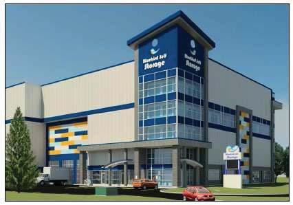
173
174
175
176
> \"C \"C (I) :l c.")
177 z ~..,.,..,. '-"" '... -~. Hi' ~ L ~, CJ SUBJECT LANDS DATE OF AERIAL IMAGERY: SPRING 2017 $ 111Tl.E: DERRY STORAGE CORPORATION I ru! NO: oz 17 / 019 wn I!I. t.,''....;_ f=-~ =--=.!l"' ~ MISSISSaUGa Produt:fdby a. -~...., ',,, ~ raw, GllOll'lltfcl I l:laldd\pnljadalrapor!mlpll\ OZ 17 _019 W11 _RP1\Veclol\OZ 17 _019_Aaflll.clgn )> "C "C (I) :l c.. x "'
178 ϭϭζ t/ E/E' z /E^d EK s^ϯϭϭϭ ϭϳζ t/ E/E' z /E^d EK ϭϯϲθϰϭ / d ^ Wh >/,/',t z ^ /E zͳ> t EK ϳϬͲϴϳ ϰϭϭ Ϭ ϬϬϬ Wz>KE ^/'E ϴϴϬϬ ϳϵϬϬ ϭϯϳϱ K^ ϭϭϭ ϭϯϭϭ ϭϭϭ >/E K& Ks Z, E' ϬϬ Zϭϱ ϴ ϯϵθϯ & K K^ ϭϭ ϮϲϬϬ ϮϲϬϬ ϮϲϬϬ ϭϯ >/E K& Ks Z, E' ^>KW ϭθϭϭŵŵ dž ϲϭϭŵŵ / z > ^W t / z > Z < ^ Ϯ ϭϭϭͿ ϭϯ WZKs/ ϮϬϬŵŵ Z /E&KZ KE Z d &>KKZ &KZ ' Z ' ZKKD ' Z ' ZKKD ϭϯϭϭ ϮϬϬϵϮ ϮϲϬϬ dzw ^W ϬϬ >/E K& ^ KE &>KKZ Ks d,z s,/ h> Z EdZ E ^ >/E K& Ks Z, E' ϮϬ ϲ ϰϯ &d D /E ^>KW ϰ ϱŵ ^ d < >/E K& Ks Z, E' ϱϳϳϯϳ ))( %/'* )22735,17 VT P VT IW (' 6725(< 6725$*( )$&,/,7< t ϯ Ks Z, KKZ^ ϭϰζdžϭϲζͿ Θ ϯ >K /E' ^W ^ ϯ ϱŵ dž ϭϯŵ dž ϳŵ s Zd/ >, /',dͿ Ϯ ^dkz z >K /E' K < EdZ E ^/ D ^ KEE d/ke ϮϲϬϬ ϭϭ ϮϬϬϬŵŵ dž ϮϬϬϬŵŵ KE Z d W d y/d KKZ & ϯϰϭϭ dzw ϵ EdZ E ϭϱϭϭ ϱ ϱϯϭϭ dzw ^EKt ^dkz ' ϭϳ ϭϲ ϭϱ ϭϰ ϰϱϳϯ ϭϱϭϭ ϭ dk^ ϭϭϭϭϭ ^ d < ^ dk d < ϭϭϭϭϭ ^ WZKWK^ >/D/d K& s >KWD Ed ϭϭŵ ^ d < &ZKD >> / Ed/&/, Z KE^dZ /Ed^Ϳ ϭ ϱŵ ^ d < &ZKD WZKWK^ >/D/d K& s >KWD Ed ^ dk Z/W >/E ^ ^d < z d, /dz K& D/^^/^^ h' E d, Z /d s >> z KE^ Zs d/ke hd,kz/dz KE ^ Wd D Z ϲ ϮϬϭϳ ϮϬϬϬŵŵ dž ϮϬϬϬŵŵ KE Z d W d y/d KKZ ϭθϭϭ Ϭ ϱϭ < d Ϭ ^ ϭϭϭϭ ϯϭŵ Z ^/ ^ d < dk^ dk K^^ K ϯϱϭϭ ϮϲϬϬ ϲϳϭϭ dzw W Z >> > ^W ϰ dkw K& E< ^ ^d < z d, /dz K& D/^^/^^ h' E d, Z /d s >> z KE^ Zs d/ke hd,kz/dz KE ^ Wd D Z ϲ ϮϬϭϳ ϲ Ϭŵ ^ d < K^ Zϭ ϱϭ dk^^ ϯϭϭϳϵ ^ d < dk > ZZz ZK ϱϭϭ d dk dk^ &/Z,z Z Ed ϳ ϮϰϬϬ dzw dz E Z Ed dk E ϯ dk^ ddk^^ K^ dk^ dk K^^ K Ϯ Zϭ WZ >/D/E Zz D E Z >d K^ d < ϰ ϱŵ ^ K^ $SSHQGL[ )LOH 2= : 3URSRVHG &RQFHSW 3ODQ ϵϭϭϭ &/Z > E ϱϯϭϭ dzw ^W ϮϭϬϬ ϱϳϯϭ /Z, z ddk^^ ϭϯϯ ϰŵ > K& EdZ E dk > K& &hdhz : Ed EdZ E ' K& y/^d/e' ^W, >d ZK y/^d/e' KE Z d ^/ t >< ϭϱϭϭ ϭϵθϱϰ & K^ K ddk K^ K dk^ dk^ dk^ dk^ dk^ dk^ ϭϰϳϰ y/^d/e' > K& ZK ϳ ϱŵ ^ d < dk^ dk^ dk^ dk^ dk^ dk^ dk^ dk^ y/d ϮϲϬϬ ϮϲϬϬ ϮϲϬϬ ϮϲϬϬ ϮϲϬϬ ϭθϭϭ ϱϯϵϯ ϯϲϭϲϳ &/Z > E > E'd, dk dk^ y/d ϵϭϭϭ &/Z > E ϱϯϭϭ dzw W Z</E' ^W ϮϭϬϬ ϭϯϱϭ ϭθϭϭ ϰϱϳϯ ϭ K^ K ^ dk dz E^&KZD Z K^ K ϬϬ ϰϱθϭϯ ϰϱϲϵ ϰϭ y/d K^^ dk dk^ dk^ dk^ ZK >>Kt E dt E >Kd^ ϭϭ E ϭϭ KE ^^/KE ϭ t ^d K&,hZKEd Z/K ^dz dͿ ZZz ZK t ^d 'HUU\ 6WRUDJH &RUSRUDWLRQ ϯϭϭϭϭ Z/',d dhze > E ϳϰŵ d W Z dk y/^d/e' hz >/E ^ W Z Z '/KE ^d E Z ^ dk^ dk^ dk^ dk^ dk^ dk^ dk dk^ dk^ dk^ K dk^ dk dk^ K^ ddk^ ϯϵθϯ dk^ dk^ dk^ dk^ dk^ K K^^ K^ K K^ dk^ K^ K^ dk^ K^ dk^ K^ dk^ K ^ dk^ K^ dk^ K^ ϵϭϭ ^ K^ K^ K^ K^ dk^ K^ K ^ K^ y/d K K^ K dk dk K^^ K K^ ϱϭϭ Ϯϴ dk^ K^ K^ K^ dk^ dk^ ϭϲ ^>KW ^d />/dz Z ^d dk^ K^ dk^ ϭϭй & dkz K& ^ & dz ^ dk^ dk^ ^ dk K W KddKD K& ^>K K^ Ϯϰϯ K^ ^ K K ^ K^ K^ K^ K^^ K K^ Ϭ ϳ ϱŵ ^ d < dk^ dk^ dk^ dk^ dk^ ^ dk ϱϭϭϭ


179 1st Floor U/S Deck th Floor th Floor th Floor 3rd Floor nd Floor L K1 K J H G F E D C B1 B A2 A U/S Deck th Floor th Floor th Floor rd Floor nd Floor st Floor U/S Deck th Floor th Floor th Floor rd Floor nd Floor st Floor 0 A A1 B C D E E1 F G G1 H J K K1 L U/S Deck th Floor th Floor th Floor rd Floor nd Floor st Floor 0

180 1r================================================ ~ DERRY ROAD WEST, PART OF SCHEDULE 10 LAND USE DESIGNATIONS OF MISSISSAUGA OFFICIAL Pl.AN LAND USE DESIGNATIONS D Residential Low Density J D Airport D Residential Low Density II D Institutional - Residential Medium Density - Public Open Space - Residential High Density - Private Open Space - MixedUse D Greenlands - Convenience Commercial D Parkway Belt West - Motor Vehicle Commercial D Utility D Office ~ Special Waterfront D Business Employment i:::: Partial Approval Area - Industrial... ~ Civic Centre (City Hall) City CentreTransit Terminal = GO Rail Transit Station - LBPIA Operating Area Boundary Public School See Aircraft Noise Policies i Catholic School 1?Zii11 Area Exempt from LBPIA Operating Area Hospital m Natural Hazards tll Community Facilities BASE MAP INFORMATION H Heritage Conservation District c NEP/2000 NEF :!O Composite Noise Contours City Structure ~ Downtown ~ Corporate Centre!iii Major Node H Employment Area ~ Community Node!iii Special Purpose Area D Neighbourhood ~\; I I SUBJECT LANDS.p TTTLE: EVAN PERLMAN GLEN SCHNARR & ASSOCIATEs INC. (GSAI) IFILE NO: oz 17/019 W11 I!I' ;;, / ;;, y " / ;;, / / 1 ~ M1ss1ssauGa,.~...:. I l:lcadd\projects\reportmaps\ OZ 17_019 W11_RP'TWec!Dr\OZ 17 _019_L.andllae.dgn )> "C "C (I) ::::I a. )(" U'I

181 .... ~ ! Existing Zoning and General Context Map OZ 17/019 W11 Appendix 6 ~~~~;;;;;;;;~~..-~~;;;;;;;;~~;p;;;~~;;;;;;;;;;l;;;;;;;;;;;;;;;;;;;;;~~~llllllllllllllfj D E2-119 R11-1 E2-120 E2-78 C:Z-14 C3-46 D C5 OS3-4 DER!1Y ROAD WEST C5-12 I,.., D RM4 E2-28 ~~.. ::~- E2-28 E2-28 ~ OS1 ~i I RM2-32 Ji ~ G:Z-1 KROTON CRESCENT"' 10 E2 LONGSIDE DRIVE H-E2-126 RM2-32 E2 E2 G2-3 H-E:Z-126 ~ ~i...;;;... ~~~~~~~~~~~"-'-~~ ~~~~~~~... ~;...~~~~~...i...i..~~~~~~~~~... ~.i...~~.1" julrwya
Edward R. Sajecki Commissioner of Planning and Building
 Corporate Report Clerk s Files Originator s Files CD.03.POR DATE: TO: FROM: SUBJECT: Chair and Members of Planning and Development Committee Meeting Date: February 27, 2012 Edward R. Sajecki Commissioner
Edward R. Sajecki Commissioner of Planning and Building. SUBJECT: Draft Lakeview Local Area Plan (January 2014)
") Corporate Report Clerk s Files Originator s Files CD.03.LAK DATE: TO: FROM: Chair and Members of Planning and Development Committee Meeting Date: February 3, 2014 Edward R. Sajecki Commissioner of Planning
Corporate Report Clerk s Files Originator s Files CD.03.LAK DATE: TO: FROM: Chair and Members of Planning and Development Committee Meeting Date: February 3, 2014 Edward R. Sajecki Commissioner of Planning
and Richmond Street West - Official Plan Amendment Application - Preliminary Report
 STAFF REPORT ACTION REQUIRED 822-838 and 860-862 Richmond Street West - Official Plan Amendment Application - Preliminary Report Date: August 14, 2017 To: From: Wards: Reference Number: Toronto and East
1071 King Street West Zoning Amendment Application - Preliminary Report
 STAFF REPORT ACTION REQUIRED 1071 King Street West Zoning Amendment Application - Preliminary Report Date: August 9, 2012 To: From: Wards: Reference Number: Toronto and East York Community Council Director,
Bloor St. W. Rezoning - Preliminary Report
 STAFF REPORT ACTION REQUIRED 1638-1644 Bloor St. W. Rezoning - Preliminary Report Date: April 1, 2008 To: From: Wards: Reference Number: Toronto and East York Community Council Acting Director, Community
10 Park Lawn Rd - Zoning Amendment Application- Preliminary Report
 STAFF REPORT ACTION REQUIRED 10 Park Lawn Rd - Zoning Amendment Application- Preliminary Report Date: March 9, 2012 To: From: Wards: Reference Number: Etobicoke York Community Council Director, Community
Official Plan Review: Draft Built Form Policies
 PG.30.1 REPORT FOR ACTION Official Plan Review: Draft Built Form Policies Date: May 15, 2018 To: Planning and Growth Management Committee From: Chief Planner and Executive Director, City Planning Division
Figure 1- Site Plan Concept
 Figure 1- Site Plan Concept Parking will be provided underground on three levels at rate of 1.0 space/ unit; this rate includes all visitors parking. MMM Group has prepared a parking assessment (April,
30 and 44 Zorra Street - Zoning By-law Amendment Application - Preliminary Report
 STAFF REPORT ACTION REQUIRED 30 and 44 Zorra Street - Zoning By-law Amendment Application - Preliminary Report Date: March 14, 2016 To: From: Wards: Reference Number: Etobicoke York Community Council Director,
1296 Kennedy Road - Zoning Amendment Application - Preliminary Report
 STAFF REPORT ACTION REQUIRED 1296 Kennedy Road - Zoning Amendment Application - Preliminary Report Date: January 15, 2016 To: From: Wards: Reference Number: Scarborough Community Council Acting Director,
178 Carruthers Properties Inc.
 178 Carruthers Properties Inc. Planning Rationale for 178 Carruthers Avenue Site Plan Control Application June 2014 Table of Contents 1.0 Introduction 2.0 Overview of Subject Property 3.0 Current Zoning
Official Plan Review
 Official Plan Review Summary Report - The Built Environment August 2014 Part 1: Introduction Planning for a healthy, prosperous and sustainable community is an important goal for our municipality. From
4780 Eglinton Avenue West - Zoning By-law Amendment and Draft Plan of Subdivision Applications - Preliminary Report
 STAFF REPORT ACTION REQUIRED 4780 Eglinton Avenue West - Zoning By-law Amendment and Draft Plan of Subdivision Applications - Preliminary Report Date: May 29, 2014 To: From: Wards: Reference Number: Etobicoke
5959 Yonge Street Rezoning Application - Preliminary Report
 STAFF REPORT ACTION REQUIRED 5959 Yonge Street Rezoning Application - Preliminary Report Date: February 23, 2011 To: From: Wards: Reference Number: North York Community Council Director, Community Planning,
280 Manse Road - Official Plan Amendment, Zoning Amendment, Draft Plan of Subdivision Applications - Preliminary Report
 STAFF REPORT ACTION REQUIRED 280 Manse Road - Official Plan Amendment, Zoning Amendment, Draft Plan of Subdivision Applications - Preliminary Report Date: March 11, 2014 To: From: Wards: Reference Number:
7437, 7439 and 7441 Kingston Road - Zoning By-law Amendment and Site Plan Control Applications - Preliminary Report
 STAFF REPORT ACTION REQUIRED 7437, 7439 and 7441 Kingston Road - Zoning By-law Amendment and Site Plan Control Applications - Preliminary Report Date: August 13, 2015 To: From: Wards: Reference Number:
Eglinton Avenue East & 50 Thermos Road - Official Plan Amendment Application Preliminary Report
 STAFF REPORT ACTION REQUIRED 1966 2050 Eglinton Avenue East & 50 Thermos Road - Official Plan Amendment Application Preliminary Report Date: March 15, 2016 To: From: Wards: Reference Number: Scarborough
Trafalgar Road Corridor Planning Study Open House
 Trafalgar Road Corridor Planning Study Open House June 24, 2013 6:30-8:30 p.m. Oakville & Trafalgar Rooms Overview The Livable Oakville Plan identifies the lands along Trafalgar Road, between the QEW and
Queen Street West - Zoning Amendment Application - Preliminary Report
 STAFF REPORT ACTION REQUIRED 944-952 Queen Street West - Zoning Amendment Application - Preliminary Report Date: February 6, 2013 To: From: Wards: Reference Number: Toronto and East York Community Council
4155 Yonge Street Official Plan Amendment and Rezoning Application Preliminary Report
 STAFF REPORT ACTION REQUIRED 4155 Yonge Street Official Plan Amendment and Rezoning Application Preliminary Report Date: May 5, 2011 To: From: Wards: Reference Number: North York Community Council Director,
5 TOWN OF MARKHAM OFFICIAL PLAN AMENDMENT NO. 144 MILLIKEN MAIN STREET SECONDARY PLAN
 5 TOWN OF MARKHAM OFFICIAL PLAN AMENDMENT NO. 144 MILLIKEN MAIN STREET SECONDARY PLAN The Planning and Economic Development Committee recommends the following: 1. The communication from Brendan O Callaghan,
ONTARIO MUNICIPAL BOARD
 PL 120483 ONTARIO MUNICIPAL BOARD Applicant/Appellant: 2124123 Ontario Limited Subject: OPA, Rezoning and Draft Plan of Subdivision Municipal Address: 3940 Highway 7 East Municipality: City of Markham
599 Kennedy Road - Official Plan Amendment and Zoning Amendment Application - Preliminary Report
 STAFF REPORT ACTION REQUIRED 599 Kennedy Road - Official Plan Amendment and Zoning Amendment Application - Preliminary Report Date: March 7, 2017 To: From: Wards: Reference Number: Scarborough Community
Planning and Growth Management Committee. Chief Planner and Executive Director, City Planning Division. Pg12013 (File No NNY 34 OZ)
") 865 York Mills Road Official Plan Amendment Application Preliminary Report STAFF REPORT ACTION REQUIRED Date: February 28, 2012 To: From: Wards: Reference Number: Planning and Growth Management Committee
865 York Mills Road Official Plan Amendment Application Preliminary Report STAFF REPORT ACTION REQUIRED Date: February 28, 2012 To: From: Wards: Reference Number: Planning and Growth Management Committee
4121 Lawrence Avenue East Rezoning Application Preliminary Report
 STAFF REPORT ACTION REQUIRED 4121 Lawrence Avenue East Rezoning Application Preliminary Report Date: October 11, 2011 To: From: Wards: Reference Number: Scarborough Community Council Director, Community
YONGE STEELES CORRIDOR SECONDARY PLAN. Young + Wright / IBI Group Architects Dillon Consulting Ltd. GHK International (Canada) Ltd.
 Ltd.") PART A: PREAMBLE 1.0 PURPOSE The purpose of this Secondary Plan is to provide a development framework for intensification of the Yonge/ Steeles corridor including the north side of Steeles Avenue West
PART A: PREAMBLE 1.0 PURPOSE The purpose of this Secondary Plan is to provide a development framework for intensification of the Yonge/ Steeles corridor including the north side of Steeles Avenue West
8 Oak Street - Official Plan and Zoning By-law Amendment Application - Preliminary Report
 STAFF REPORT ACTION REQUIRED 8 Oak Street - Official Plan and Zoning By-law Amendment Application - Preliminary Report Date: March 17, 2014 To: From: Wards: Reference Number: Planning and Growth Management
9 CITY OF VAUGHAN OFFICIAL PLAN AMENDMENT NO BOCA EAST INVESTMENTS LIMITED
 9 CITY OF VAUGHAN OFFICIAL PLAN AMENDMENT NO. 631 - BOCA EAST INVESTMENTS LIMITED The Planning and Economic Development Committee recommends the adoption of the recommendations contained in the following
2136 & 2148 Trafalgar Road Town of Oakville Region of Halton
 PLANNING JUSTIFICATION REPORT 2136 & 2148 Trafalgar Road Town of Oakville Region of Halton Zoning By-Law Amendment Application 2500674 Ontario Inc. November 2016 Table of Contents Page 1.0 Location/Summary
LAKEVIEW LOCAL ADVISORY PANEL. THE COPORATION OF THE CITY OF MISSISSAUGA THURSDAY, NOVEMBER 18, 2010
 LAKEVIEW LOCAL ADVISORY PANEL THE COPORATION OF THE CITY OF MISSISSAUGA www.mississauga.ca/lakeviewportcreditreview THURSDAY, NOVEMBER 18, 2010 MISSISSAUGA SENIORS CENTRE LUCY TURNBALL ROOM (1389 Cawthra
13 THORNHILL YONGE STREET STUDY IMPLEMENTATION CITY OF VAUGHAN OPA 669 AND TOWN OF MARKHAM OPA 154
 13 THORNHILL YONGE STREET STUDY IMPLEMENTATION CITY OF VAUGHAN OPA 669 AND TOWN OF MARKHAM OPA 154 The Planning and Economic Development Committee recommends the adoption of the recommendations contained
150 Eighth Street Zoning By-law Amendment Application Preliminary Report
 REPORT FOR ACTION 150 Eighth Street Zoning By-law Amendment Application Preliminary Report Date: March 27, 2019 To: Etobicoke York Community Council From: Director, Community Planning, Etobicoke York District
240 and 242 Finch Avenue West Zoning By-law Amendment Application Preliminary Report
 REPORT FOR ACTION 240 and 242 Finch Avenue West Zoning By-law Amendment Application Preliminary Report Date: March 1, 2019 To: North York Community Council From: Director, Community Planning, North York
QUEEN-RIVER SECONDARY PLAN
 34 QUEEN-RIVER SECONDARY PLAN 34. QUEEN RIVER SECONDARY PLAN 1. INTRODUCTION The Queen-River area is approximately 6.4 hectares and is located at the eastern edge of the Downtown as shown on Map 34-1.
MOUNT PLEASANT SECONDARY PLAN & VILLAGE BLOCK PLAN. Wednesday, March 5, 2008 Informal Public Open House
 MOUNT PLEASANT SECONDARY PLAN & VILLAGE BLOCK PLAN Wednesday, March 5, 2008 Informal Public Open House 1. Welcome & Introductions 2. Highlights of Provincial Growth Plan 3. Overview and Status Update -
Table of Contents 1.0 Introduction
 Table of Contents 1.0 Introduction..1 2.0 Site Description and Surrounding Land Uses 1 3.0 Redevelopment Proposal..3 4.0 Provincial, Regional and Municipal Policy Context... 10 4.1 The Provincial Policy
1.0 Purpose of a Secondary Plan for the Masonville Transit Village
 Report to Planning and Environment Committee To: Chair and Members Planning & Environment Committee From: John M. Fleming Managing Director, Planning and City Planner Subject: Masonville Transit Village
393, 395, 397, 399, 401 and 403 Spring Garden Avenue Official Plan and Zoning By-law Amendment Application Preliminary Report
 STAFF REPORT ACTION REQUIRED 393, 395, 397, 399, 401 and 403 Spring Garden Avenue Official Plan and Zoning By-law Amendment Application Preliminary Report Date: March 29, 2010 To: From: Wards: Reference
5 Direct Growth. 5.1 Introduction
 5 Direct Growth 5.1 Introduction Mississauga s population and employment growth prospects are expected to remain strong over the next 25 years. Mississauga has sufficient land to accommodate projected
646 Kingston Road - Official Plan Amendment and Zoning Amendment Applications - Preliminary Report
 STAFF REPORT ACTION REQUIRED 646 Kingston Road - Official Plan Amendment and Zoning Amendment Applications - Preliminary Report Date: December 8, 2014 To: From: Wards: Reference Number: Toronto and East
1 Introduction. Chapter. In this chapter:
 Chapter 1 Introduction In this chapter: 1.1 A Snapshot of the Region 1.2 Towards a Sustainable Region 1.3 The Provincial Context 1.4 Purpose and Organization The Regional Municipality of York Official
Mark-up of the effect of the proposed Bronte Village Growth Area OPA No.18 on the text of section 24, Bronte Village, of the Livable Oakville Plan
 Mark-up of the effect of the proposed Bronte Village Growth Area OPA No.18 on the text of section 24, Bronte Village, of the Livable Oakville Plan Notes: This document is provided for information purposes
Edward R. Sajecki Commissioner of Planning and Building. Land Use Review- Former Parkway Belt West Lands- Fieldgate Drive and Audubon Boulevard
 Corporate Report Clerk s Files Originator s Files CD.04.FOR DATE: November 15, 2011 TO: FROM: SUBJECT: Chair and Members of Planning and Development Committee Meeting Date: December 5, 2011 Edward R. Sajecki
Welcome. Walk Around. Talk to Us. Write Down Your Comments
 Welcome This is an information meeting introducing the applications for proposed redevelopment of the Yorkdale Shopping Centre site at 3401 Dufferin Street and 1 Yorkdale Road over the next 20+ years,
Sustainable Growth. Sustainable Growth
 2 Sustainable Growth Sustainable Growth SUSTAINABLE GROWTH 2.1 COMMUNITY VISION... 2-5 2.2 THE CITY SYSTEM... 2-7 2.2.1 AREAS... 2-7 2.2.2 CITY-WIDE SYSTEMS... 2-8 2.2.3 PROVINCIAL PLAN BOUNDARIES AND
K. SMART ASSOCIATES LIMITED
 Planning Justification Report Zoning By-Law Amendment 185 King Street North Waterloo, Ontario April 7th, 2017 Project Reference Number 16-245 K. SMART ASSOCIATES LIMITED CONSULTING ENGINEERS AND PLANNERS
Draft Urban Hamilton Official Plan. Amendment No. XX
 1 of 75 The following text, together with: Draft Appendix A Appendix B Volume 1, Schedule E-1 Urban Land Use Designations Appendix C Volume 1, Appendix A Parks Classification Map Appendix D Volume 1, Appendix
2901 Bayview Avenue and 630 Sheppard Avenue East - Official Plan Amendment and Zoning Amendment Application - Preliminary Report
 STAFF REPORT ACTION REQUIRED 2901 Bayview Avenue and 630 Sheppard Avenue East - Official Plan Amendment and Zoning Amendment Application - Preliminary Report Date: September 27, 2017 To: From: Wards: Reference
A Growing Community Rural Settlement Areas
 Town of Huntsville Official Plan Review - POLICY BACKGROUND PAPER A Growing Community Rural Settlement Areas BACKGROUND: In addition to the fully municipally-serviced Urban Settlement Area and the Hidden
Bayview Avenue Official Plan Amendment, Zoning Amendment and Site Plan Control Applications Request for Direction Report
 STAFF REPORT ACTION REQUIRED 2425 2427 Bayview Avenue Official Plan Amendment, Zoning Amendment and Site Plan Control Applications Request for Direction Report Date: May 28, 2015 To: From: Wards: Reference
HEMSON C o n s u l t i n g L t d.
 INVENTORY & ASSESSMENT OF INTENSIFICATION OPPORTUNITIES City of Brampton Discussion i Paper for Public Review C o n s u l t i n g L t d. November 2008 EXECUTIVE SUMMARY This report is one of the key background
PLANNING AND URBAN DESIGN RATIONALE REPORT. Hunters Pointe Golf Course Redevelopment 289 Daimler Parkway Prepared For: Ontario Ltd.
 PLANNING AND URBAN DESIGN RATIONALE REPORT Hunters Pointe Golf Course Redevelopment 289 Daimler Parkway Prepared For: 2599587 Ontario Ltd. February 2018 Redevelopment of Hunters Pointe Golf Course, Welland
60-64 Queen Street East and Church Street - Zoning Amendment Application - Preliminary Report
 STAFF REPORT ACTION REQUIRED 60-64 Queen Street East and 131-135 Church Street - Zoning Amendment Application - Preliminary Report Date: March 15, 2018 To: From: Wards: Reference Number: Toronto and East
Table 8-4: Road Classification Local Roads, second table, of Chapter 8 Create a Multi-Modal City, be amended by adding the following:
 1 Port Street East Official Plan Amendment APPENDIX 3 Amendments to Mississauga Official Plan Table 8-4: Road Classification Local Roads, second table, of Chapter 8 Create a Multi-Modal City, be amended
From: Director, Community Planning, Scarborough District. Ward 40 Scarborough-Agincourt
 STAFF REPORT ACTION REQUIRED 2967 Sheppard Ave E - Zoning Amendment Application - Preliminary Report Date: July 18, 2014 To: Scarborough Community Council From: Director, Community Planning, Scarborough
Director, Community Planning, Etobicoke York District
 STAFF REPORT ACTION REQUIRED Baby Point Gates Planning Study 227-430 Jane Street, 665-685 Annette Street, 494 Armadale Avenue, 143 Evans Avenue and 502 504 Willard Avenue Status Report Date: August 11,
STAFF REPORT. December 20, North York Community Council. Director, Community Planning, North York District
 STAFF REPORT December 20, 2005 To: From: Subject: North York Community Council Director, Community Planning, North York District Preliminary Report Application to Amend the Official Plan and Zoning By-law
523, 525 and 525A Adelaide Street West - Zoning Amendment Application - Preliminary Report
 STAFF REPORT ACTION REQUIRED 523, 525 and 525A Adelaide Street West - Zoning Amendment Application - Preliminary Report Date: May 12, 2012 To: From: Wards: Reference Number: Toronto and East York Community
THE CORPORATION OF THE TOWN OF OAKVILLE BY-LAW NUMBER
 THE CORPORATION OF THE TOWN OF OAKVILLE BY-LAW NUMBER 2017-120 A by-law to adopt an amendment to the Livable Oakville Plan, Official Plan Amendment Number 20 (Downtown Oakville Growth Area) WHEREAS the
TABLE OF CONTENTS 1.0 INTRODUCTION... 3
 TABLE OF CONTENTS 1.0 INTRODUCTION... 3 1.1. BACKGROUND... 3 1.2. THE PROPOSAL... 5 2.0 EXISTING POLICY FRAMEWORK... 5 2.1. PROVINCIAL POLICY STATEMENT (PPS)... 5 2.2. CITY OF LONDON OFFICIAL PLAN (OP)...
SUBJECT: Proposed Downtown Mobility Hub Precinct Plan and Proposed Official Plan Policies
 Page 1 of Report PB-81-17 SUBJECT: Proposed Downtown Mobility Hub Precinct Plan and Proposed Official Plan Policies TO: FROM: Committee of the Whole Planning and Building Department Report Number: PB-81-17
PUBLIC MEETING April, 20161
 PUBLIC MEETING April, 20161 The Study Area Study Area Focus Area Corridor Neighbourhoods 2 Today s Presentation This material is aimed at providing viewers with enough background to be able to think about
2494 Danforth Avenue - Official Plan Amendment and Zoning Amendment Application - Preliminary Report
 STAFF REPORT ACTION REQUIRED 2494 Danforth Avenue - Official Plan Amendment and Zoning Amendment Application - Preliminary Report Date: March 15, 2018 To: From: Wards: Reference Number: Toronto and East
Proposed High-Density Apartment Building
 Planning Justification Report 1287 Costigan Road, Milton Proposed High-Density Apartment Building by IBI Group July 6, 2016 Table of Contents 1 Introduction... 1 2 Site and Area Details... 1 2.1 Neighbourhood
112 College Street Zoning Amendment Application Preliminary Report
 ~TORONTO REPORT FOR ACTION 112 College Street Zoning Amendment Application Preliminary Report Date: January 25, 2019 To: Toronto and East York Community Council From: Director, Community Planning, Toronto
1120 Haist Street - Pelham Arena Community Co-Design Recommendation Report Haist Street - Pelham Arena Community Co-Design Recommendation Report
 1120 Haist Street - Pelham Arena Community Co-Design Executive Summary: In May, 2017 the Town retained the services of The Planning Partnership to undertake a community design charrette process to determine
6 Growth Management Challenges and Opportunities
 6 Growth Management Challenges and Opportunities The Town has established a goal of attaining a 50% participation rate with respect to employment opportunities versus residential population. The Town s
Brampton. Secondary Plan. Review. Bram West. A New Direction in Planning & Public Consultation
 Brampton Bram West Secondary Plan Review A New Direction in Planning & Public Consultation Introduction The Bram West Secondary Plan Review offers an important opportunity for the community to define a
The protection of the agricultural resources of the Province;
 PART II INTRODUCTION An Official Plan is a policy document, which is intended to serve as the basis for making land use decisions and managing change in any municipality in Ontario. According to the Planning
808 Mount Pleasant Road Zoning Amendment Application Request for Interim Direction Report
 STAFF REPORT ACTION REQUIRED 808 Mount Pleasant Road Zoning Amendment Application Request for Interim Direction Report Date: June 15, 2018 To: From: Wards: Reference Number: Toronto and East York Community
Background Summary Report
 Background Summary Report May 2014 Submitted by Macaulay Shiomi Howson Ltd. In association with AMEC MMM Group Brook McIlroy Inc. Hemson Consulting Ltd. Table of Contents 1. Introduction... 1 2. Why is
PUBLIC OPEN HOUSE HURONTARIO-MAIN CORRIDOR SECONDARY PLAN
 PUBLIC OPEN HOUSE HURONTARIO-MAIN CORRIDOR SECONDARY PLAN Tuesday, February 28, 2012 6pm 9pm 1 st Floor Atrium, City Hall 2 Wellington Street West, Brampton 1 POLICY FRAMEWORK The 2006 Provincial Growth
1.0 PLANNING MARKHAM S FUTURE CONTENTS
 1-1 Planning Markham s Future 1.0 PLANNING MARKHAM S FUTURE CONTENTS 1.1 THE PURPOSE OF THE OFFICIAL PLAN 1.2 THE MARKHAM CONTEXT 1.3 THE REGULATORY CONTEXT 1.3.1 Province of Ontario 1.3.2 York Region
4800 Yonge Street - Official Plan Amendment, Zoning Amendment and Site Plan Applications - Request for Direction Report
 STAFF REPORT ACTION REQUIRED 4800 Yonge Street - Official Plan Amendment, Zoning Amendment and Site Plan Applications - Request for Direction Report Date: April 16, 2018 To: From: Wards: Reference Number:
NOTE: PLEASE REFER TO CITY PLAN FOR ADDITIONAL CITY-WIDE POLICIES WHICH APPLY TO THIS DISTRICT.
 NOTE: THE POLICIES IN THIS DOCUMENT ARE SPECIFIC TO THE SHERIDAN RESIDENTIAL PLANNING DISTRICT OF, AND MUST BE READ IN CONJUNCTION WITH ALL THE POLICIES OF CITY PLAN PLEASE REFER TO FOR ADDITIONAL CITY-WIDE
Director, Community Planning, North York District
 STAFF REPORT ACTION REQUIRED 36 and 37 Jane Osler Boulevard and 42 and 44 Cartwright Avenue Zoning By-law Amendment and Draft Plan of Subdivision Approval Applications - Preliminary Report Date: May 22,
1-17 Anndale Drive, Bales Avenue and Glendora Avenue Zoning Amendment Application Preliminary Report
 STAFF REPORT ACTION REQUIRED 1-17 Anndale Drive, 31-35 Bales Avenue and 22-70 Glendora Avenue Zoning Amendment Application Preliminary Report Date: August 20, 2007 To: From: Wards: Reference Number: North
CONTENTS 8.0 LAND USE 8.1 GENERAL LAND USE 8.2 RESIDENTIAL 8.3 MIXED USE 8.4 COMMERCIAL 8.5 EMPLOYMENT LANDS
 8-2 Land Use 8.0 LAND USE CONTENTS 8.1 GENERAL LAND USE 8.1.1 Uses provided for in all Land Use Designations 8.1.2 Uses prohibited in Hazardous Lands, Hazardous Sites and Special Policy Areas 8.1.3 Uses
and services The protection and conservation of environmentally significant and sensitive natural heritage features and functions.
 6. Land Use 6.0 Preamble A healthy and livable city is one in which people can enjoy a vibrant economy and a sustainable healthy environment in safe, caring and diverse neighbourhoods. In order to ensure
30 Bay Street and 50 Harbour Street - Zoning Amendment Application - Preliminary Report
 STAFF REPORT ACTION REQUIRED 30 Bay Street and 50 Harbour Street - Zoning Amendment Application - Preliminary Report Date: May 18, 2018 To: From: Wards: Reference Number: Toronto and East York Community
1151 Queen Street East - Zoning Amendment Application - Preliminary Report
 STAFF REPORT ACTION REQUIRED 1151 Queen Street East - Zoning Amendment Application - Preliminary Report Date: June 12, 2018 To: From: Wards: Reference Number: Toronto and East York Community Council Acting
THE CITY OF VAUGHAN BY-LAW BY-LAW NUMBER A By-law to adopt Amendment Number 1 to the Official Plan of the Vaughan Planning Area.
 THE CITY OF VAUGHAN BY-LAW BY-LAW NUMBER 015-2014 A By-law to adopt Amendment Number 1 to the Official Plan of the Vaughan Planning Area. NOW THEREFORE the Council of the Corporation of the City of Vaughan
CITY CLERK. Parkland Acquisition Strategic Directions Report (All Wards)
") CITY CLERK Clause embodied in Report No. 10 of the, as adopted by the Council of the City of Toronto at its meeting held on November 6, 7 and 8, 2001. 10 Parkland Acquisition Strategic Directions Report
CITY CLERK Clause embodied in Report No. 10 of the, as adopted by the Council of the City of Toronto at its meeting held on November 6, 7 and 8, 2001. 10 Parkland Acquisition Strategic Directions Report
North York Community Council. Director, Community Planning, North York District. Ward No. 26, Don Valley West
 STAFF REPORT ACTION REQUIRED 85 Laird Drive Zoning Application - Final Report Date: December 18, 2007 To: From: Wards: Reference Number: North York Community Council Director, Community Planning, North
PORT WHITBY COMMUNITY
 PORT WHITBY COMMUNITY SECONDARY PLAN UPDATE COMMUNITY IMPROVEMENT PLAN URBAN DESIGN GUIDELINES September 2015 DRAFT PROPOSED AMENDMENT NUMBER # to the Whitby Official Plan PURPOSE: The intent of this Amendment
1285 Queen Street East - Zoning Amendment Application - Request for Direction Report
 STAFF REPORT ACTION REQUIRED 1285 Queen Street East - Zoning Amendment Application - Request for Direction Report Date: June 14, 2018 To: From: Wards: Reference Number: Toronto and East York Community
1407 Military Trail Zoning Amendment Application Final Report
 STAFF REPORT ACTION REQUIRED 1407 Military Trail Zoning Amendment Application Final Report Date: October 17, 2013 To: From: Wards: Reference Number: Scarborough Community Council Director, Community Planning,
20 & 50 Ashtonbee Road, 1920 & 1940 Eglinton Avenue East, and 880, 890 & 900 Warden Avenue Zoning Amendment Application Final Report
 STAFF REPORT ACTION REQUIRED 20 & 50 Ashtonbee Road, 1920 & 1940 Eglinton Avenue East, and 880, 890 & 900 Warden Avenue Zoning Amendment Application Final Report Date: August 16, 2012 To: From: Wards:
Corporation of the City of Cambridge Planning and Development Committee Meeting No
 Corporation of the City of Cambridge Planning and Development Committee Meeting No. 02-19 Historic City Hall - 46 Dickson Street Tuesday, January 29, 2019 7:00 p.m. AGENDA Meeting Called to Order Disclosure
THE STRUCTURE OF THE PLAN...
 TABLE OF CONTENTS THE STRUCTURE OF THE PLAN... 1 A1 THE COMMUNITY VISION... 3 A2 GOALS AND OBJECTIVES... 3 A2.1 THE NATURAL ENVIRONMENT... 3 A2.1.1 Goal... 3 A2.1.2 Objectives... 3 A2.2 GROWTH AND SETTLEMENT...
Urban Design Manual PLANNING AROUND RAPID TRANSIT STATIONS (PARTS) Introduction. Station Study Areas
 Introduction. Station Study Areas") 111111 PLANNING AROUND RAPID TRANSIT STATIONS (PARTS) Introduction The ION rapid transit system will link Waterloo, Kitchener and Cambridge through a central transit corridor (CTC). There are a number
111111 PLANNING AROUND RAPID TRANSIT STATIONS (PARTS) Introduction The ION rapid transit system will link Waterloo, Kitchener and Cambridge through a central transit corridor (CTC). There are a number
burlington mobility hubs study Downtown Burlington Mobility Hub
 burlington mobility hubs study Downtown Burlington Mobility Hub Draft Precinct Plan Workbook PIC #3, September 7, 2017 downtown mobility hub objectives City staff and their consultants are proposing an
70 and 80 Wicksteed Avenue, 202, 204 and 206. Parkhurst Boulevard and 99 Vanderhoof Avenue
 STAFF REPORT ACTION REQUIRED 70 and 80 Wicksteed Avenue, 202, 204 and 206 Zoning By-law Amendment Application Preliminary Report Date: December 13, 2011 To: From: Wards: Reference Number: North York Community
2655 Lawrence Ave East - Rezoning Application - Preliminary Report
 STAFF REPORT ACTION REQUIRED 2655 Lawrence Ave East - Rezoning Application - Preliminary Report Date: June 17, 2008 To: From: Wards: Reference Number: Scarborough Community Council Director, Community
Summary of Changes for the Comprehensive Draft Proposed Official Plan Amendment
 Summary of Changes for the Comprehensive Draft Proposed Official Plan Amendment Note: Due to the broad scope of the Official Plan Review, this list is not exhaustive of the extent of changes in the comprehensive
SUBJECT: Revised proposed new official plan recommended for adoption
 Page 1 of Report PB-04-18 SUBJECT: Revised proposed new official plan recommended for adoption TO: FROM: Planning and Development Committee Department of City Building Report Number: PB-04-18 Wards Affected:
12 AMENDMENT NO. 149, TOWN OF MARKHAM HIGHWAY 404 NORTH SECONDARY PLAN
 12 AMENDMENT NO. 149, TOWN OF MARKHAM HIGHWAY 404 NORTH SECONDARY PLAN The Planning and Economic Development Committee recommends the adoption of the recommendation contained in the following report August
Report to: Development Services Committee Report Date: September 11, 2017
 ~RKHAM Report to: Development Services Committee Report Date: September 11, 2017 SUBJECT: PREPARED BY: Conceptual Master Plan for the Future Urban Area - Community Structure Plan and Key Policy Direction
350, 370, and 390 Queens Quay West Official Plan Amendment and Zoning Amendment Applications - Preliminary Report
 STAFF REPORT ACTION REQUIRED 350, 370, and 390 Queens Quay West Official Plan Amendment and Zoning Amendment Applications - Preliminary Report Date: April 22, 2016 To: From: Wards: Reference Number: Toronto
NOTE: PLEASE REFER TO MISSISSAUGA PLAN FOR ADDITIONAL CITY-WIDE POLICIES WHICH APPLY TO THIS DISTRICT.
 NOTE: THE POLICIES IN THIS DOCUMENT ARE SPECIFIC TO THE FAIRVIEW PLANNING DISTRICT OF, AND MUST BE READ IN CONJUNCTION WITH ALL THE POLICIES OF PLEASE REFER TO FOR ADDITIONAL CITY-WIDE POLICIES WHICH APPLY