Level 1 Downstream Analysis
|
|
|
- Alban Holt
- 5 years ago
- Views:
Transcription
1 Level 1 Downstream Analysis Newcastle Way Apartments Newcastle, Washington King County April 14, 2014 Revised July 10, 2014 Prepared by: Dean A. Furr, P.E. Reviewed by: Donald Scarberry, P.E. Coffman Engineering, Inc. # /10/14
2 NEWCASTLE WAY APARTMENTS NEWCASTLE, WA LEVEL 1 DOWNSTREAM 3.0 OFF-SITE ANALYSIS The new 80-unit mixed-use multi-family development, Newcastle Way Apartments, is located adjacent to the City of Newcastle City Hall, near the intersection of Newcastle Way SE and 129 TH Avenue SE. More generally the site is located at the NE ¼ of Section 28, Township 24N, Range 5 WM in the City of Newcastle, Washington. Task 1: Study Area Definition and Maps Contributory upstream drainage from the adjacent PSE transmission line easement is considered insignificant because most of the surface runoff is intercepted by the gravel trail and conveyed south around the project site. Surface runoff from the development to the west is intercepted by the ditch within the PSE easement and conveyed south around the site. All upstream drainage north of the site is conveyed by the existing drainage ditches and culverts located along Newcastle Way SE and within city right of way and converges with the sites runoff. The Newcastle Way Apartments project contributes only a small percentage of the tributary drainage within the Coal Creek Basin. All onsite runoff flows eastward and is intercepted by the unimproved ditch and culvert drainage system along Newcastle Way SE. Stormwater enters a catch basin at the end of the improved Newcastle Way SE curb/gutter/sidewalk located near the south east corner of the site. Stormwater continues southward through the improved storm drainage system where it flows southward within 129th Avenue SE. This exceeds the ¼ mile downstream analysis. The site contributes less than 15 percent of the total tributary sub-basin at the downstream analysis limit, in accordance with the King County SWDM. Task 2: Resource Review Adopted Basin Plans and Finalized Drainage Studies The project site is within the Coal Creek Basin Plan, published by King County, in The conditions noted and recommendations for development have been incorporated into current storm water control design requirements (KCSWDM) and the City of Newcastle Storm and Surface Water Comprehensive Plan. Basin Reconnaissance Summary Reports: Drainage patterns and conditions for much of King County were outlined in the King County Basin Reconnaissance Program in approximately Recommendations were incorporated into the current design. CEI Project Page 1
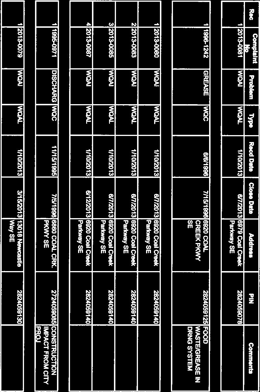
3 NEWCASTLE WAY APARTMENTS NEWCASTLE, WA Floodplain/Floodway (FEMA) maps: LEVEL 1 DOWNSTREAM There are no FEMA floodplains within the study area of the Coal Creek Basin Offsite Analysis Reports: The Newcastle Professional Center is located adjacent to the site to the east. The TIR (Hugh Goldsmith and Associates, Inc., October 2005) was reviewed for potential additional drainage related problems, existing or predicted, within the common downstream reach of this development. It is was found that this development is within the Lake Boren drainage basin and has no effect on the proposed project. Senstitive Areas Folio: Review of the Geologic and Hydrologic Maps on King County s IMAP the site is located within a: Upper tributary Basin - Coal Creek Drainage Basin High Basin Condition - Areas with low development intensity (e.g., substantial forest cover, relatively few roads crossing aquatic areas and wetlands, low amounts of impervious surfaces, and low amounts armoring and structures along shorelines) and a significant biological value (e.g., the presence or high use by critical species or the presence of rare, endangered or highly sensitive habitats). The site is located outside of an erosion, seismic, landslide, coal mine, susceptible to groundwater contamination, sole source aquifer, stream, channel migration hazard, 100year flood plain, Chinook distribution and wildlife network areas. Drainage Complaints: Review of the IMAP shows 8 drainage complaints occurred downstream from the project. The latest complaint date was on January 10, All drainage complaints have been closed. Wetlands Inventory: There is a wetland located beyond the downstream study area at the south end of an unknown tributary to Coal Creek and near the north end of QFC shopping. The wetland has been mapped by King County, map folio ID 0603 with a wetland rating of 2. Task 3: Field Inspection A field investigation was performed on April 9, The weather was approximately 60 degrees and partly sunny, am showers. Review of the historical data shows an accumulation of 0.43 inches for the month of April and inches for the year. March had 8.33 inches of rainfall. No signs of erosion were observed for the downstream conveyance and the current system appears to have capacity. CEI Project Page 2
4 NEWCASTLE WAY APARTMENTS LEVEL 1 DOWNSTREAM NEWCASTLE, WA Task 4: Drainage System Description and Problem Description The existing downstream drainage course for the project area starts at the catch basin located at the end of the Newcastle Way roadway improvements near the southeast corner of the site. Stormwater enters a 12 inch culvert and flows into the aforementioned Type 1 catch basin. Stormwater continues to flow southward and turning eastward within the storm system where it enters a catch basin at the southeast corner of the Newcastle Way and 129th Ave NE intersection. This catch basin is located within the sidewalk and has a solid cover. From there the stormwater flows eastward where it enters a Type 2 SDMH with a solid cover located in the bus lane. The stormwater is conveyed northward under Newcastle Way SE through an 18 CMP where it enters a SDMH with a solid cover in the sidewalk. The stormwater is conveyed through a 24 pipe to a SDMH located in the Coal Creek Village parking lot near the northwest corner of the Newcastle Way and Coal Creek Parkway intersection. The stormwater flows northward to a SDMH with solid cover. The stormwater flows eastward under Coal Creak Parkway through a series of catch basins that have solid covers within the Arco gas station parking lot. The storm water is conveyed to a SDMH in the landscape area between the Arco and Bank of America. The stormwater is conveyed eastward within the drive lane of the QFC loading area. This terminates the ¼ mile of the study area. Stormwater eventually flows northward where it enters Coal Creek and ultimately discharges into Lake Washington. Task 5: Mitigation of Existing or Potential Problems There are no significant existing or predicted drainage problems with respect to the proposed project. Mitigation of potential development impacts will be achieved by conformance to the 2009 KCSWDM and the current city municipal code and Storm water Management Plan. CEI Project Page 3
5 EXHIBITS


6
7


8
9
CHECKLIST FOR PHASE II DRAINAGE REPORT
 I. COVER SHEET CHECKLIST FOR PHASE II DRAINAGE REPORT A. Name of Project B. Address C. Owner D. Developer E. Engineer F. Submittal date and revision dates as applicable II. GENERAL LOCATION AND DESCRIPTION
Stormwater Regulations & Considerations Morse Study Area. Pam Fortun, P.E. CFM Senior Stormwater Treatment Engineer Engineering Services Division
 Stormwater Regulations & Considerations Morse Study Area Pam Fortun, P.E. CFM Senior Stormwater Treatment Engineer Engineering Services Division Stormwater Regulations Development Considerations Floodplain
When planning stormwater management facilities, the following principles shall be applied where possible.
 2.0 Principles When planning stormwater management facilities, the following principles shall be applied where possible. 2.0.1 Drainage is a regional phenomenon that does not respect the boundaries between
South Bismarck Watershed Model Update and Stormwater Improvement Project
 Preliminary Engineering Report Bismarck Tribune South Bismarck Watershed Model Update and Stormwater Improvement Project City of Bismarck, ND January 2017 14.105.0046 1.0 Executive Summary The focus of
Leduc Industrial Outline Plan SE W4
 Leduc Industrial Outline Plan SE 1-50-25-W4 Within the North Leduc Industrial ASP Prepared for: Leduc Energy Park Ltd. Prepared by: Stantec Consulting Ltd. File No. 1161 104655 V5 Table of Contents 1.0
Radnor Township. Factors affecting storm water issues.
 Radnor Township Factors affecting storm water issues. Climate Changes and Changing Weather Patterns Intensity of rains over the last 7 to 10 years. Larger number of smaller storms delivering greater amounts
Problem Understanding
 Introduction...2-1 Previous Data and Mapping...2-2 Known Problem Areas...2-3 Resident Survey.2-3 Introduction The Village of Downers Grove stormwater system includes storm sewers, streams, wetlands, roadway
PRELIMINARY DRAINAGE REPORT LATHAM 200 MMSCFD GAS PROCESSING PLANT
 PRELIMINARY DRAINAGE REPORT LATHAM 200 MMSCFD GAS PROCESSING PLANT LOTS B, RECORDED EXEMPTION 1211-2-1, RECX13-0096 LOCATED IN THE NORTH 1/2 OF SECTION 2, TOWNSHIP 3 NORTH, RANGE 66 WEST, 6 TH PRINCIPAL
MASTER DEVELOPMENT DRAINAGE PLAN FOR MONUMENT HEIGHTS
 MASTER DEVELOPMENT DRAINAGE PLAN FOR MONUMENT HEIGHTS DRAINAGE REPORT STATEMENT ENGINEER'S STATEMENT: The attached drainage plan and report were prepared under my direction and supervision and are correct
City of Waco Stormwater Management Regulations
 1.0 Applicability: City of Waco Stormwater Management Regulations These regulations apply to all development within the limits of the City of Waco as well as to any subdivisions within the extra territorial
Washington County, Maryland Division of Public Works Policy Manual
 Washington County, Maryland Division of Public Works Policy Manual Subject: Downstream Drainage Easement Category: Land Development Engineering Number: 7-4.1 Date: June 1, 2009 (effective) PURPOSE: The
7.0 SOCIAL, ECONOMIC, AND ENVIRONMENTAL ISSUES
 7.0 SOCIAL, ECONOMIC, AND ENVIRONMENTAL ISSUES The following list of social, economic, and environmental issues have been identified based on a preliminary inventory of resources in the project area, an
Stormwater Retrofitting: The Art of Opportunity. Presented by the Center for Watershed Protection
 Stormwater Retrofitting: The Art of Opportunity Presented by the Center for Watershed Protection What Are Stormwater Retrofits? Retrofits are stormwater management measures inserted in an urban or ultra-urban
Description of Preferred Alternative
 Chapter 2 Description of Preferred Alternative 2.1 Introduction This chapter of the programmatic Sammamish Town Center Sub-area Plan Final EIS provides a more detailed description of the Preferred Alternative
Urban Water Management and Soils (ESRM 311 & SEFS 507)
") Urban Water Management and Soils (ESRM 311 & SEFS 507) Cougar Mtn Regional Wildland Park & Lakemont Blvd, Bellevue WA Lecture Today Some Urban Water management terms Examples of water management in urban
Urban Water Management and Soils (ESRM 311 & SEFS 507) Cougar Mtn Regional Wildland Park & Lakemont Blvd, Bellevue WA Lecture Today Some Urban Water management terms Examples of water management in urban
Chapter 4 - Preparation of Stormwater Site Plans
 Chapter 4 - Preparation of Stormwater Site Plans The Stormwater Site Plan is the comprehensive report containing all of the technical information and analysis necessary for the City to evaluate a proposed
Existing Conditions and Environmental Consequences Floodplains
 3.9 Environmental Consequences 3.8 3.8.1 WHAT ARE FLOODPLAINS? are low-lying areas adjacent to rivers, streams, and other waterbodies that are susceptible to inundation (flooding) during rain events. These
Why a new Food & Farm Ordinance?
 Growing for Kane Why a new Food & Farm Ordinance? 1. Growing obesity issue 64% of Kane adults are overweight or obese 2. Low rates of fruit & vegetable consumption Healthy diets include more fruits & veggies.
ST. MARY S SOIL CONSERVATION DISTRICT (SMSCD) AND DPW&T CONCEPT EROSION AND SEDIMENT CONTROL AND STORMWATER MANAGEMENT GUIDELINES AND CHECKLIST
 AND DPW&T CONCEPT EROSION AND SEDIMENT CONTROL AND STORMWATER MANAGEMENT GUIDELINES AND CHECKLIST") St. Mary s Soil Conservation District 26737 Radio Station Way, Suite B Leonardtown, MD 20650 Phone: 301-475-8402 ext. 3 Fax: 301-475-8391 www.stmarysscd.com St. Mary s County Government Department of Public
St. Mary s Soil Conservation District 26737 Radio Station Way, Suite B Leonardtown, MD 20650 Phone: 301-475-8402 ext. 3 Fax: 301-475-8391 www.stmarysscd.com St. Mary s County Government Department of Public
Appendix K. Stormwater Management Plan
 Regional Municipality of Halton - Steeles Avenue (Regional Road 8) Class EA - Industrial Drive to Regional Road 25/Martin Street Appendix K Stormwater Management Plan PR226401.001 Rev. 2 PR.DOT, 00/01
Lincoln 270. City of Lincoln. Stormwater Management Plan. April 2, 2013
 Lincoln 270 City of Lincoln Stormwater Management Plan April 2, 2013 # 2005.48 Prepared By: Civil Engineering Solutions, Inc. 590 E Street Lincoln, Ca 95648 (916) 645 5700 1.0 Background: The project site
Appendix I. Checklists
 Appendix I Checklists Town of Greenwich Drainage Manual Department of Public Works - Engineering Division Town Hall - 101 Field Point Road, Greenwich, CT 06836-2540 Phone 203-622-7767 - Fax 203-622-7747
City of Elmhurst. City of Elmhurst. Storm Sewer System Workshop November 22, 2010
 City of Elmhurst City of Elmhurst Storm Sewer System Workshop November 22, 2010 1 City of Elmhurst Watershed divide (green dashed line) through Elmhurst Area east of divide drains to Addison Creek Area
ORDINANCE NUMBER DRAFT. An ordinance amending Title 12 Environmental Protection of the Los Angeles County
 ORDINANCE NUMBER DRAFT 1 1 1 1 1 1 0 1 An ordinance amending Title 1 Environmental Protection of the Los Angeles County Code, establishing Low Impact Development standards. The Board of Supervisors of
STORMWATER SITE PLAN INSTRUCTIONS AND SUBMITTAL TEMPLATE Medium and Large Projects
 DEPARTMENT OF COMMUNITY DEVELOPMENT 621 Sheridan Street, Port Townsend, WA 98368 Tel: 360.379.4450 Fax: 360.379.4451 Web: www.co.jefferson.wa.us/communitydevelopment E-mail: dcd@co.jefferson.wa.us STORMWATER
CITY OF TUMWATER 555 ISRAEL RD. SW, TUMWATER, WA (360) (360) (FAX)
 (360) (FAX)") CITY OF TUMWATER 555 ISRAEL RD. SW, TUMWATER, WA 98501 (360) 754-4180 (360) 754-4126 (FAX) Email: cdd@ci.tumwater.wa.us APPENDIX II-C SHORT FORM CONSTRUCTION STORMWATER POLLUTION PREVENTION PLAN (SWPPP)
CITY OF TUMWATER 555 ISRAEL RD. SW, TUMWATER, WA 98501 (360) 754-4180 (360) 754-4126 (FAX) Email: cdd@ci.tumwater.wa.us APPENDIX II-C SHORT FORM CONSTRUCTION STORMWATER POLLUTION PREVENTION PLAN (SWPPP)
Post Construction BMPs
 Post Construction BMPs Why are Post Construction BMPs important? With increased development brings the increase of impervious cover Parking lots, rooftops, driveways Storm water runoff volume increases
Floodplain Technical Memorandum
 Southeast Extension Project Lincoln Station to RidgeGate Parkway Prepared for: Federal Transit Administration Prepared by: Denver Regional Transportation District May 2014 Table of Contents Page No. Chapter
WQ-23 MOUNTAINOUS AND STEEP SLOPE SITES
 Greenville County Technical Specification for: WQ-23 MOUNTAINOUS AND STEEP SLOPE SITES 1.0 Mountainous and Steep Slope Sites 1.1 Description The geographic locations of portions of Greenville County are
HAZARD MITIGATION GOALS AND OBJECTIVES
 SEWRPC Community Assistance Planning Report No. 282, 2nd Edition CITY OF MILWAUKEE ALL HAZARDS MITIGATION PLAN UPDATE Chapter IV HAZARD MITIGATION GOALS AND OBJECTIVES [NOTE: Throughout this plan update
A. INTRODUCTION AND SUMMARY OF FINDINGS B. EXISTING CONDITIONS. Table 10-1 Adjacent Storm Drains
 Chapter 10: Stormwater Management A. INTRODUCTION AND SUMMARY OF FINDINGS This chapter describes existing and proposed stormwater management on the Site. Potential impacts to stormwater infrastructure
LOUISIANA STATE UNIVERSITY COMPREHENSIVE & STRATEGIC CAMPUS MASTER PLAN. APPENDIX G - Stormwater Study Findings & Stormwater Solutions
 LOUISIANA STATE UNIVERSITY COMPREHENSIVE & STRATEGIC CAMPUS MASTER PLAN APPENDIX G - Stormwater Study Findings & Stormwater Solutions LSU: MP Narrative July 2017 3.5 Open Space Existing Conditions The
Section 3 Non-Structural BMPs
 3.1 Stream Buffers A stream buffer or stream setback is a designated area around a stream, lake, or wetland left in a natural, densely vegetated state so as to protect the receiving water quality and provide
APPENDIX A SIMPLIFIED APPROACH TO STORMWATER MANAGEMENT FOR SMALL PROJECTS. In West Sadsbury Township, Chester County, Pennsylvania
 APPENDIX A SIMPLIFIED APPROACH TO STORMWATER MANAGEMENT FOR SMALL PROJECTS In West Sadsbury Township, Chester County, Pennsylvania TABLE OF CONTENTS I. Introduction 3 II. Importance of Stormwater Management
Better Cycling. The City will update the cycling master plan (London ON Bikes) based on the approved BRT network.
 based on the approved BRT network.") Better Cycling Dedicated bike facilities will be constructed along BRT corridors where space is available. Nearby bike routes will also be upgraded to ensure a complete network is available for cyclists.
Better Cycling Dedicated bike facilities will be constructed along BRT corridors where space is available. Nearby bike routes will also be upgraded to ensure a complete network is available for cyclists.
Pond Siting Report Update
 Pond Siting Report Update Prepared for: Florida Department of Transportation District 5 CR 46A Realignment from SR 46 to North of Arundel Way Lake County, Florida FPID No. 238275-8-32-02 October 2013 (Draft
Putting a LID on Stormwater Pollution. Michele Loudenback, RPES Stormwater Enforcement Water Quality Division
 Putting a LID on Stormwater Pollution Michele Loudenback, RPES Stormwater Enforcement Water Quality Division Outline Brief Regulatory History Conventional vs. Green Practices LID/GI Controls in Use Clean
Chesapeake Bay Critical Area Conservation Plan
 The Maryland-National Capital Park and Planning Commission Prince George s County Planning Department Development Review Division 301-952-3530 Note: Staff reports can be accessed at www.mncppc.org/pgco/planning/plan.htm.
POLE BRIDGE ROAD NEAR FIVE LOT FARM
 Drainage Improvements Village of Avon Pole Bridge Road near Five Lot Farm December 2014 POLE BRIDGE ROAD NEAR FIVE LOT FARM Pole Bridge Road is the eastern border of the Village south of NYS route 5 &
City of Troutdale South Troutdale Road Storm Drainage Plan
 City of Troutdale South Troutdale Road Storm Plan January 29 City of Troutdale SOUTH TROUTDALE ROAD STORM DRAINAGE PLAN January 29 Prepared for: City of Troutdale 342 SW 4th Street Troutdale, OR 976 Prepared
October 7, City of Thornton 9500 Civic Center Drive Thornton, CO (303) RE: Maverik Thornton, CO - Drainage Report
 RE: Maverik Thornton, CO - Drainage Report") October 7, 2016 City of Thornton 9500 Civic Center Drive Thornton, CO 80229 (303) 538-7295 RE: Maverik Thornton, CO - Drainage Report As per your request, we are submitting to you the drainage report and
October 7, 2016 City of Thornton 9500 Civic Center Drive Thornton, CO 80229 (303) 538-7295 RE: Maverik Thornton, CO - Drainage Report As per your request, we are submitting to you the drainage report and
Chapter 3 Site Planning and Low Impact Development
 CHAPTER 3 Site Planning and Low Impact Development Chapter 3 Site Planning and Low Impact Development 3.0 Introduction The City of Charleston requires that major residential, large commercial (>1 acre),
USF System Campus Master Plan Updates Goals, Objectives and Policies
 2015-2025 USF System Campus Master Plan Updates Goals, Objectives and Policies Tampa Goals, Objectives, and Policies Table of Contents Executive Summary 2015 2025 USF Campus Master Plan Update Introduction
STORMWATER MASTER PLAN
 STORMWATER MASTER PLAN Prepared for CITY OF DES PLAINES 1420 MINER STREET DES PLAINES, IL 60016 July 2003 CBBEL Project No. 02-73 TABLE OF CONTENTS Page # LIST OF TABLES... v LIST OF EXHIBITS... vi LIST
ENBRIDGE GAS DISTRIBUTION INC. Proposed Relocation for Ninth Line, Markham and Whitchurch-Stouffville. Environmental Screening Report
 Page 1 of 18 ENBRIDGE GAS DISTRIBUTION INC. Proposed Relocation for Ninth Line, Markham and Whitchurch-Stouffville Environmental Screening Report July 2011 Page 2 of 18 Table of Contents 1.0 INTRODUCTION
Understanding Stormwater Drainage Maintenance
 WARREN COUNTY STORMWATER DISTRICT Understanding Stormwater Drainage Maintenance Home Owner s Association Guide Introduction Our goal is to help property owners and Home Owner s Associations (HOA) understand
NAPA COUNTY PUBLIC WORKS Standards & Specifications
 Roadway Design & Construction Manual (Table of Contents) 1. Chapter 1: General Provisions 1.1 Short Title 1.2 Jurisdiction 1.3 Purpose and Effect 1.4 Enactment Authority 1.5 Amendment and Revisions 1.6
Draft Rhode Island Stormwater Design and Installation Standards Manual
 Draft Rhode Island Stormwater Design and Installation Standards Manual Summary The May 2009 Public Review Draft version of the RI Stormwater Design and Installation Standards Manual consists of approximately
Checklists. Project Name: Location: File Number: Date of Submittal: Reviewer: Date: Applicant: Contact Name: Phone Number:
 Applicant: Contact Name: Phone Number: Email: Project Name: Location: File Number: Date of Submittal: Reviewer: Date: Concept Plan Requirements: I. General Project Information 1. Address or parcel number
Urban Water Management (ESRM 311 & SEFS 507) Cougar Mtn Regional Wildland Park & Lakemont Blvd, Bellevue WA
 Cougar Mtn Regional Wildland Park & Lakemont Blvd, Bellevue WA") Urban Water Management (ESRM 311 & SEFS 507) Cougar Mtn Regional Wildland Park & Lakemont Blvd, Bellevue WA Lecture Today Urban Water management terms Examples of water management in urban areas Field
Urban Water Management (ESRM 311 & SEFS 507) Cougar Mtn Regional Wildland Park & Lakemont Blvd, Bellevue WA Lecture Today Urban Water management terms Examples of water management in urban areas Field
North Branch of Cypress Creek Ecological Restoration: A Comprehensive Approach to Stream Restoration
 North Branch of Cypress Creek Ecological Restoration: A Comprehensive Approach to Stream Restoration Rocky Powell Clear Creeks Consulting, LLC Keith D. Tate, P.E. BayLand Consultants & Designers, Inc.
PHASE III DRAINAGE REPORT
 PHASE III DRAINAGE REPORT FOR Eastlake Assisted Living & Memory Care April 20, 2016 June 3, 2016 August 5, 2016 Prepared for: 3301 E 120 th Ave, LLC. 8200 E. Maplewood Ave., Suite 150 Greenwood Village
TOWNSHIP OF LOGAN SOIL & FILL IMPORTATION AND PLACEMENT APPLICATION SUBMITTAL CHECKLIST
 TOWNSHIP OF LOGAN SOIL & FILL IMPORTATION AND PLACEMENT APPLICATION SUBMITTAL CHECKLIST Applications: 5 copies of application - Applicant will reproduce the copies at his/her costs. The Township Clerk
8.5 FLOODING. Environmental Setting
 8.5 FLOODING This section evaluates flooding impacts associated with the proposed General Plan, including whether implementing the plan will: (1) permit the construction of housing within a 100-year Flood
C. WATER. 1. Surface Water Runoff. See Section C.3, Flood Hazard/Mudflow Hazard, page Ground Water
 C. WATER 1. Surface Water Runoff See Section C.3, Flood Hazard/Mudflow Hazard, page 67. 2. Ground Water Determined not significant by the October 1984 and January 1999 Initial Studies conducted by the
Bostwick Road. Municipal Class Environmental Assessment. October 13, City of London. Bostwick Road Municipal Class Environmental Assessment
 Bostwick Road Municipal Class Environmental Assessment October 13, 2016 Welcome! Welcome to the first Public Information Centre for the Bostwick Road Municipal Class Environmental Assessment. Representatives
Major Subdivision Sketch Plan Checklist
 This checklist provides specific requirements that are apart of the Sketch process. The entire process is described by the Huntersville Subdivision Review Process which details all the submittal and resubmittal
Riparian Buffer on the Bushkill Creek. Policies
 Riparian Buffer on the Bushkill Creek Riparian buffers provide numerous benefits to landowners and the community by protecting groundwater recharge areas, providing flood control, providing stormwater
City of Elmhurst. Comprehensive Flood Plan. City of Elmhurst. City Council Meeting September 15, 2014
 City of Elmhurst City of Elmhurst Comprehensive Flood Plan City Council Meeting September 15, 2014 City of Elmhurst Presentation Overview Study Background Study Methodology Analysis of Three Additional
Community LID Workgroup Issue Paper #6
 Community LID Workgroup Issue Paper #6 Topic: Hard and Impervious Surface Coverage Limits Objective: Minimize the amount of hard and impervious surfaces in developments to allow more stormwater to infiltrate
City of Grande Prairie Development Services Department KENNEDY DEVELOPMENTS LTD. OUTLINE PLAN OP-09-01
 City of Grande Prairie Development Services Department KENNEDY DEVELOPMENTS LTD. OUTLINE PLAN OP-09-01 July 27, 2009 TABLE OF CONTENTS 1.0 Introduction... 1 1.1 Plan Area Location & Context... 1 1.2 Ownership
Drexel, Barrell & Co.
 Drexel, Barrell & Co. June 18, 2018 Engineers/Surveyors Boulder Colorado Springs Greeley 3 South 7 th Street Colorado Springs, Colorado 80905-1501 719 260-0887 719 260-8352 Fax El Paso County Planning
STORMWATER REPORT FOR WALMART SUPERCENTER STORE # SIOUX FALLS, LINCOLN COUNTY, SOUTH DAKOTA BFA PROJECT NO
 STORMWATER REPORT FOR WALMART SUPERCENTER STORE # 2443-00 SIOUX FALLS, LINCOLN COUNTY, SOUTH DAKOTA BFA PROJECT NO. 3286 March 1, 2012 I hereby certify that this engineering document was prepared by me
Storm Water Quality and Shoreline Restoration Improvements - Grant Funding Request City of Mound Carlson Park Bolton & Menk Project No.
 September 15, 2016 Brett Eidem Cost Share Grant Administrator Minnehaha Creek Watershed District 15320 Minnetonka Boulevard Minnetonka, MN 55345 RE: Storm Water Quality and Shoreline Restoration Improvements
Table of Contents G.1.a Water Resources - Surface Water - Drainage
 Table of Contents G.1.a Water Resources - Surface Water - Drainage 1. INTRODUCTION... 1335 2. ENVIRONMENTAL SETTING... 1335 a. Regional Hydrology... 1335 b. Local Hydrology... 1337 c. On-site Hydrology...
Stormwater Runoff and the District of Columbia RiverSmart Homes Defined:
 Stormwater Runoff and the District of Columbia Stormwater runoff is rainwater that flows off impervious surfaces such as rooftops, driveways, roads, sidewalks and sometimes even lawns. Stormwater runoff
5. FINAL DEVELOPMENT PLAN APPROVAL MENORAH MEDICAL CENTER OFFICE BUILDING Vicinity of the southwest corner of 119 th Street and Nall Avenue
 5. FINAL DEVELOPMENT PLAN APPROVAL MENORAH MEDICAL CENTER Avenue 1. APPLICANT: Hoefer Wysocki Architects, L.L.C., is the applicant for this request. 2. REQUESTED ACTION: The applicant is requesting final
Storm Water Management Workshop
 Storm Water Management Workshop The following questions were asked during the breakout sessions for the Storm Water Management Workshops held on February 26, 2018 and March 2, 2018. Wildlife / Vegetation
Review Zone Application for D&R Canal Commission Decision
 Review Zone Application for D&R Canal Commission Decision MEETING DATE: July 20, 2016 DRCC #: 16-4803 Latest Submission Received: June 13, 2016 Applicant: Robert McCarthy, PE PSE&G 4000 Hadley Road, 2
6.1. INTRODUCTION 6.2. EXISTING CONDITIONS
 Chapter 6: Stormwater Management 6.1. INTRODUCTION This Chapter describes the current drainage patterns on the Project Site, the stormwater management system that is proposed as part of the Proposed Project,
Schematic Design Stormwater Site Plan University Ridge Bellingham, Washington
 Schematic Design Stormwater Site Plan University Ridge Bellingham, Washington Tax Parcel Number: 380332 172175 Prepared By: Freeland & Associates, Inc. 220 West Champion St., Suite 290 Bellingham, WA 98225
MANUAL OF DESIGN, INSTALLATION, AND MAINTENANCE REQUIREMENTS FOR STORMWATER MANAGEMENT PLANS
 MANUAL OF DESIGN, INSTALLATION, AND MAINTENANCE REQUIREMENTS FOR STORMWATER MANAGEMENT PLANS May 2007 SECTION 1 Responsibility of Applicant TABLE OF CONTENTS A. Stormwater Management Plan Required Information
Introduction to Low Impact Development. Fred Milch. East Central Florida Regional Planning Council
 Introduction to Low Impact Development Fred Milch East Central Florida Regional Planning Council Low Impact Development (LID) Low impact development (LID) is a term used to describe a land planning and
OP Council Resolution June 16, Planning and Development Services
 OP-08-01 Council Resolution June 16, 2008 Planning and Development Services Kingsgate Landing Outline Plan Table of Contents 1.0 Introduction 1 1.1 Purpose of Plan 1 1.2 Plan Area Location 1 1.3 Ownership
A Review of Green Infrastructure Projects Implemented in the Grand Traverse Region
 A Review of Green Infrastructure Projects Implemented in the Grand Traverse Region Sarah U Ren Program Director The Watershed Center of Grand Traverse Bay 231-935-1514, suren@gtbay.org Our Mission: The
Working Group Meeting
 April 4,, 2017 Parks Operations Bldg Working Group Meeting Arts Districts Overview Stormwater/RPA/Stream Considerations First Principles Agenda 7:00pm 7:05pm 7:10pm 7:40pm 8:30pm 9:40pm 9:45pm Welcome
City of Dade City AMEC Project No Dade City Stormwater Master Plan September 2012 Page 32
 Page 32 3.0 MAJOR DRAINAGE SYSTEMS The 1965 Master Plan Report for Storm Drainage Facilities ( 1965 Master Plan ) identified six primary subwatersheds within the Dade City study area. Each of these areas
The Benefits and Challenges Associated with Green Infrastructure Practices
 The Benefits and Challenges Associated with Green Infrastructure Practices Thomas M. Evans ASLA, LEED AP Regional Green Infrastructure Design Services Director OWEA Technical Conference, June 20, 2013
Poisoned Park? How Exide s Lead Contamination Risks Frisco s Grand Park
 Frisco City Hall has big plans to transform Stewart Creek into a Grand Park with lots of water features for kids to play in. Poisoned Park? How Exide s Lead Contamination Risks Frisco s Grand Park But
Response to Comments (July 28, 2010 Oregon City Determination of Application Completeness Memo)
") Environmental Science & Assessment, LLC MEMORANDUM DATE: August 13, 2010 TO: Oregon City Planning CC: Jill Long Lane Powell FROM: RE: Jack Dalton Response to Comments (July 28, 2010 Oregon City Determination
Environmental Science & Assessment, LLC MEMORANDUM DATE: August 13, 2010 TO: Oregon City Planning CC: Jill Long Lane Powell FROM: RE: Jack Dalton Response to Comments (July 28, 2010 Oregon City Determination
Huntington Stormwater Utility
 Huntington Stormwater Utility Stormwater Management & Sediment and Erosion Control Requirements for Construction Sites Authorized by Huntington City Code Articles: 971, 970, 930, 935, 955, Revised April
AGENDA ITEM: IOWA. west] that were not FISCAL IMPACT. the City of Clive. STAFF REVIEW. Resolution II. Amendment PREPARED BY: REVIEWED BY:
![AGENDA ITEM: IOWA. west] that were not FISCAL IMPACT. the City of Clive. STAFF REVIEW. Resolution II. Amendment PREPARED BY: REVIEWED BY:](/thumbs/93/112428810.jpg "AGENDA ITEM: IOWA. west] that were not FISCAL IMPACT. the City of Clive. STAFF REVIEW. Resolution II. Amendment PREPARED BY: REVIEWED BY:") AGENDA ITEM: CITY OF WAUKEE, IOWA CITY COUNCIL MEETING COMMUNICATION MEETING DATE: March 7, 2016 AGENDA ITEM: Consideration of approval of a resolution approving Engineering Services Amendment No. 1 with
AGENDA ITEM: CITY OF WAUKEE, IOWA CITY COUNCIL MEETING COMMUNICATION MEETING DATE: March 7, 2016 AGENDA ITEM: Consideration of approval of a resolution approving Engineering Services Amendment No. 1 with
Staff will be providing an overview of the project need, purpose and intent for consideration as part of the Amendment cycle.
 Agenda Item D-2 City of Tacoma Planning and Development Services To: Planning Commission From: Stephen Atkinson, Planning Services Division Subject: Open Space Corridors Project Meeting Date: March 1,
Drexel, Barrell & Co.
 Drexel, Barrell & Co. December 21, 2018 Engineers/Surveyors Boulder Colorado Springs Greeley 3 South 7 th Street Colorado Springs, Colorado 80905-1501 719 260-0887 719 260-8352 Fax El Paso County Planning
Farmers Investment Co. (FICO) Continental Farms
 Continental Farms") Farmers Investment Co. (FICO) Continental Farms Planning & Zoning Commission Study Session (River Master Plan) January 25, 2012 FICO Property 7,000 acres total area 6,000 acres in Town of Sahuarita 1,000
Farmers Investment Co. (FICO) Continental Farms Planning & Zoning Commission Study Session (River Master Plan) January 25, 2012 FICO Property 7,000 acres total area 6,000 acres in Town of Sahuarita 1,000
Village of New Maryland. Storm Water Management Master Plan
 Village of New Maryland Storm Water Management Master Plan Village of New Maryland Storm Water Management Master Plan Fredericton Office 80 Bishop Drive Fredericton NB E3C 1B2 Canada Telephone: +1 506
IMPLEMENTING STORMWATER MANAGEMENT REQUIREMENTS FOR DEVELOPMENT
 IMPLEMENTING STORMWATER MANAGEMENT REQUIREMENTS FOR DEVELOPMENT 4.1 Overview Description: Requirements and standards for controlling runoff from development are critical to addressing water quantity and
Drainage Control Plans
 2016 Drainage Design and Erosion Control Manual - Guide Sheet 1C Drainage Control Plans A Drainage Control Plan is the comprehensive submittal package containing all of the technical information, analysis,
Stormwater Pollution Prevention Plan Oneonta Heights Oneonta, NY TABLE OF CONTENTS PAGE
 Oneonta Heights Oneonta, NY TABLE OF CONTENTS PAGE I. INTRODUCTION... 2 II. EXISTING CONDITIONS... 3 A. Topography/ Drainage... 3 B. Soils... 3 C. Wetlands... 3 D. Floodplain... 3 E. NYSDEC Environmental
WASHINGTON COUNTY OREGON
 WASHINGTON COUNTY OREGON LONG RANGE PLANNING DIVISION North Bethany Subarea Stream Corridors: Existing Regulations In Oregon, there is a distinct difference between the land use rules that apply in rural
Figure 1 Cypress Street Study Area Location Map
 July 20, 2016 TO: FROM: Jim Massarelli Director of Engineering Jeff Julkowski, PE Michael Burke, PE SUBJECT: Cypress Street Study Area Stormwater Analysis (CBBEL Project No. 16-0058) At the request of
2014 Stormwater Project Analysis
 Village of Downers Grove 2014 Stormwater Project Analysis FINAL REPORT Prepared by: Wills Burke Kelsey Associates, Ltd. 8 East Galena Boulevard Aurora, Illinois 60506 Phone: 630-701-2245 Fax: 630-800-1626
Caledon Villas Corp. c/o Mr. John Spina 55 Blue Willow Drive Woodbridge, ON L4L 9E8 May 14, Floodplain Characteristics, Old Church Road
 Caledon Villas Corp. c/o Mr. John Spina 55 Blue Willow Drive Woodbridge, ON L4L 9E8 May 14, 2013 Re: Floodplain Characteristics, Old Church Road This letter serves to confirm that I, Linda Sober, have
Introduction to the Shoreline Master Program (SMP) Update. City of Bellingham Planning Department 2005
 Update. City of Bellingham Planning Department 2005") Introduction to the Shoreline Master Program (SMP) Update City of Bellingham Planning Department 2005 Purpose of tonight s meeting: Specify which water-bodies are subject to the SMP. Identify the State
Introduction to the Shoreline Master Program (SMP) Update City of Bellingham Planning Department 2005 Purpose of tonight s meeting: Specify which water-bodies are subject to the SMP. Identify the State
PLANNING & DEVELOPMENT SERVICES 1800 Continental Place Mount Vernon, WA Inspections Office Fax
 PLANNING & DEVELOPMENT SERVICES 1800 Continental Place Mount Vernon, WA 98273 Inspections 360.336.9306 Office 360.336.9410 Fax 360.336.9416 Application will expire 6 mo from this date: Floodplain Development
City of Petersburg, VA Stormwater Utility Frequently Asked Questions
 Q. What is stormwater runoff? A. Stormwater runoff is the water that flows off roofs, driveways, parking lots, streets and other hard surfaces during rain storms. Stormwater runoff is also the rain that
Boeckman Road Extension
 Boeckman Road Extension Providing Safe Passage for Wildlife and Maintaining Habitat Connectivity By Kerry Rappold, City of Wilsonville Leslie Bliss-Ketchum, Portland State University October 20, 2008 Presentation
Highlands Region Stormwater Management Program Guidance
 DRAFT Highlands Region Stormwater Management Program Guidance Release Date: January 2016 Abstract This guidance document provides an overview of the Highlands Stormwater Management Program. It is intended
PARISH OF ASCENSION OFFICE OF PLANNING AND DEVELOPMENT PLANNING DEPARTMENT. Joint Planning and Zoning Meeting
 1. Call To Order 2. Roll Call of Members 3. Chairman's Comments PARISH OF ASCENSION OFFICE OF PLANNING AND DEVELOPMENT PLANNING DEPARTMENT Joint Planning and Zoning Meeting January 11, 2017 6:00 PM Courthouse
Red Fox Commercial Outline Plan
 Red Fox Commercial Outline Plan City of Cold Lake, Alberta Prepared by Durrance Projects Ltd and Ross W. Sharp & Associates Ltd October 2014 Rupert 1 Table of Contents 1. PURPOSE...3 1.1. Location...4