06.07 Urban Structure Urban Structure differentiated (2011 Edition)
|
|
|
- Sydney Curtis
- 5 years ago
- Views:
Transcription
1 Senate Department for Urban Development and the Environment Urban Structure Urban Structure differentiated (2011 Edition) Overview The effects of urban development upon the environment depend to a particular degree on the type and intensity of human use. For this reason, the effects on the environment are closely linked to uses and building structures. In the course of the urban development of Berlin, a multifaceted structure of buildings and open spaces has emerged. In Map 06.08, 50 differentiated section types are defined and described on the basis of their typical use, the time of their emergence and their structure of buildings and open spaces. For better readability, they have been grouped into urban structure types in Map The section types serve the purpose of further differentiating the use of the areas. Especially for the use type residential, further differentiation is required. On the one hand, areas with residential use account for more than half of the city s built-up area, and for more than one quarter of the entire area of Berlin, so that they assume a special position; on the other, the spectrum covers a broad range of other uses in residential areas which are of particular interest, since the various urban development and environmental indicators and key quanta are highly dependent on urban structure. Here, structural age, height, density, and arrangement of the buildings in relation to one another, as well as the characteristic structure of the open spaces, are particularly important. Knowledge of these various structural types, in connection with the actual use mapping in Maps and of the Environmental Atlas, constitute an essential foundation for the urban development and landscape planning investigations and development projects, both at the superordinate and the local levels. With the aid of these maps, it is also possible to derive information regarding the nature of biotope and vegetation structures, the climate situation, the consistency of the soil, the intensity of imperviousness, or the formation of new groundwater. Development of the Urban Settlement of Berlin Both the natural landscape and the development of urban settlement have made their mark on the urban structure of Berlin. Some remainders of the agriculturally used land, as well as landscapes characterized by water and forest, have to this day remained free of development: the forests in southeastern Berlin between the Spree and Dahme, and, in the West, along the Havel, and also some large contiguous agricultural areas in the north-eastern part of the city. Only a few of the once numerous creeks, ditches, ponds and wetlands are still present. After 1880: The Imperial-Era The appearance of Berlin changed most markedly at the end of the previous century, as the city developed into an industrial centre. With increasing job opportunities, many people moved to Berlin, and a growing need for housing was the result. The building activity was regulated by development plans and building codes, in which the street edge lines, the sizes of the blocks, the minimum sizes of courtyards, and the heights of buildings were stipulated. Thus, Berlin's typical dense block development with its courtyard structure emerged between 1880 and 1918 within the City Rail Circle Line. It was interspersed only by scattered decorative squares and parks, and by cemeteries. In the then-suburbs (such as Friedenau) the building code of 1892 permitted a lesser degree of property utilization than in the inner city. In these areas, lower and somewhat more generouslydimensioned block developments emerged, with decorative features and a garden-courtyard structure, as well as villa development. 1
, 3 5-storey Heterogeneous inner-city mixed development, post-war")
 Fig.")


2 Village-style mixed development in old village core areas Dense block development, closed courtyards (1870s-1918), 5-6-storey Block-edge development with large quadrangles (1920s-1940s), 3 5-storey Heterogeneous inner-city mixed development, post-war gap closures Large estates and single tower high-rise buildings (1960s- 80s), 4-11-storey Multi-storey residential development since the 1990s (1990s to present) Fig. 1: Several urban structural types from various phases of Berlin s urban development After 1918: Greater Berlin New designs developed extensively only after 1918, when the construction of wings and rear buildings was forbidden by law. At the same time, public housing construction companies took over the role of the main actors in the area of residential construction from private builders. They replaced the untilthen prevalent lot-by-lot development with the construction of larger, coherent estates outside the Circle Line, in what was then the outskirts. This development was favoured by the incorporation into Berlin of its surrounding communities in 1920, to form Greater Berlin, which made uniform planning possible. Also, the open spaces associated with housing developments were accorded greater significance, which was manifested in the greater size, usefulness and design of these open spaces, but also in the designing of public open space. Later, the large public parks and allotment garden facilities emerged, which extended in a ring shape around the turn-of-the-century inner-city core. 2
3 3 Some estates, such as the Uncle Tom Estate in Zehlendorf, continued to bear witness to the previous rural character of the area, with their woods and orchards. After 1945: The divided city Massive destruction during World War II and the political division of Berlin in 1948 influenced the further course of urban development. Some 30% of all buildings had been totally destroyed or severely damaged. Changes of almost the same proportion often with equally destructive effects on the historical plan of the city and on its structural substance ensued during the following decades, with the often radical implementation of such plans as the automobile-appropriate city and socialist urban development. The western part of Berlin received economic aid under the Reconstruction Programme (Marshall Plan). So that the war-time destruction could be removed quickly by large-scale building activity during the 50s and 60s. In the inner city, vacant lots caused by the war were closed, and whole blocks were reshaped by large-scale reconstruction and by de-coring, coupled with demolition and the construction of new buildings. The developmental goals at that time were relief of the density of inner-city development and the dispersion of municipal functions. In the outskirts, large new self-contained estates emerged with relatively high shares of open space, and with industrial areas on former open spaces between old village cores. Starting in the late 70s, construction policy began to be concentrated on the revival of the inner city. Building activity was essentially limited to small vacant lots all over West Berlin, and on the preservation-oriented reconstruction of existing structures. In the eastern part of Berlin, which received no economic support, but was in fact instead burdened by reparations, reconstruction began on a large scale only after construction of the Wall in 1961 and with the industrialization of the East Berlin construction industry. The emphasis during the 60s was on the new formation of the centre of the city on areas wiped out and cleared as the result of the war. At that time, the long-term plan was to tear down the entire pre-war building stock everywhere as the inheritance of capitalism, and to replace it with developments built in the socialist architectural style. Relatively little new living space was created during the 50s and 60s. In 1971 therefore, the housing programme was proclaimed as the main focus of the social programme. The large-scale residential areas of Marzahn, Hellersdorf etc. were built on the outskirts of town by means of industrial prefabrication. Only later did the existing old building stock regain its significance as living space worthy of preservation; it was rehabilitated with varying degrees of intensity. After 1989: The reunited city By 1992, all the concrete-plate residential estates still under construction in the eastern part of the city had been completed. In the western part, only insignificant amounts of additional construction were carried out during this period. From 1993 to 1997, construction activity involved on the one hand new suburbs at the outskirts, such as Karow-Nord, build on former farmland, and on the other, numerous major urban/capital city projects, such as the Potsdamer Platz complex, or government buildings. Moreover, other urban development projects, such as Johannistal/Adlershof or Rummelsburger Bucht, were planned and concepts were developed in order to promote the development of new urban neighbourhoods. Due to changed business conditions and development policies, some original development goals were modified, and the structural dimensions considerably reduced. Since 1997, new housing construction has been declining in the entire metropolitan area, and by 2000 had dropped back to the level of 1991, due to the reduction of subsidies; since then it has stagnated at a low level. In place of major construction projects, the first years of the 21 st century saw the closing of scattered gaps, the expansion of existing structures, and the densification of already developed areas, especially in the inner city. This involved primarily buildings with large condominiums, as well as single-family homes and duplexes. New housing construction was largely concentrated in the former East Berlin boroughs of Weißensee, Pankow, Treptow, Köpenick and Hellersdorf, where densification was carried out in existing loosely built estates (cf. FNP Report 2009). Moreover, large parts of the city centre with old buildings, especially in the eastern part of the city, have been reconstructed with the aid of various urban reconstruction and urban renewal subsidy programmes, which has involved both the building structures and the residential environment. The same is true of more than 80% of the concrete plate-type estates. Open spaces along the old Berlin Wall corridor, and abandoned railway grounds which, in the course of the decades of the division of the city, have in some cases developed into valuable segments of the natural habitat and open space system, have since reunification in some cases been re-dedicated as green spaces or memorial areas, and have thus become established as typical parts of Berlin's
4 structure of open spaces (e.g. the North Station, Gleisdreieck, Südgelände, the Berlin Wall Park, or the Bernauer Straße Berlin Wall Memorial. Statistical Base The present map was updated as of December 31, 2010, based on the 2008, 2005, 2002 and 1995 editions, where it is described in detail. The Environmental Atlas Maps Actual Use of Built-Up Areas, and 0602 Green and Open Spaces, were compiled parallel to the present maps. In the course of the updating process for the 2011 Edition (as of December 12, 2010), changes in land use between 2005 and 2010 were ascertained, and an update of the geometry of Block Map 1:5000 (ISU-5) was undertaken, and accordingly adapted to the urban structure maps. Moreover, the data base for actual use and structure mapping was subjected to an automated plausibility check on the basis of various geo-data available in the State of Berlin. Overall, the following statistical bases were used to update and check the actual use and urban structure maps: Block Map of Berlin 1:5000, Urban and Environmental Information System (ISU-5), Senate Department for Urban Development, III F; as of Dec. 31, 2010, with updated block sections Changes of the geometries of the blocks defined under the Spatial Reference System (Räumliches Bezugssystem RBS) of the Berlin-Brandenburg Office of Statistics (formerly Berlin State Statistical Office) Digital orthophotography, 2006, SenStadt Sect. III (Aerial Photography Archive) Area Monitoring, , SenStadt I A 1 Automatic Register of Properties (ALK) 1:1.000, SenStadt III C, as of June, 2010 Map of Berlin 1:5000 (K5), borough surveying offices, 1995, 2006, and January 2010 Land Use Plan, 1:50,000 (FNP), SenStadt I B 1, as of 2009 Cemetery Inventory 1:1000, SenStadt I C 2, as of 2009 Green Space Inventory 1:1000, SenStadt I C 2, as of 2010 Allotment Gardens Inventory 1:1000, SenStadt I C 2, as of 2009 Building age 1:1000, from: Städtebauliche Entwicklung Berlins seit 1650 in Karten (Development of the urban structur of Berlin since 1650 in maps), at building level, only as image, only inner city, only to ca Imperviousness 1:5000, SenStadt III F, as of 2005 Population data 1:5000, AFS and SenStadt III F, as of 2009 Habitat mapping 1:5000, SenStadt I E, as of 2009 Sports facilities, SenStadt III F, survey by the Sports Administration during the mid-1990s Land-to-Building Ratio (LBR) 1:5000, SenStadt III F, as of 2008 Vacancy analysis, SenStadt I A, as of 2009 School sites, Senate Department for Education, Science and Research, as of 2010 State Real Property 1:500, SenStadt I A, as of Methodology The maps of both the urban structure mapping system and those of the actual use mapping system used the block maps of the City and Environment Information System (ISU) as the spatial reference 4
5 5 system, and have been updated together. For the 2011 Edition, changes in land use between 2005 and 2010 have been ascertained, and updating of the geometries of the 1:5000 (ISU-5) block maps undertaken. The updating of the urban structure maps was generally carried out after that for the actual use maps, i.e., the block sections and block segments were in principle not subdivided further. The assignment of section types is generally undertaken by means of visual examination on the basis of current aerial photography and of the map of Berlin (K5) for block sections where the uses which cannot automatically be assigned to a certain section type. For areas assigned both to the Map Actual Use of Built-Up Areas and to Map Green and Open Spaces (dual use), there are generally two possible approaches: a) type assignment is carried out in accordance with structural use b) type assignment is carried out according to green and open space use. Previously, the data stock was structured in such a way that dual use areas were assigned to the section type of green and open space use. That meant that for these areas, the actual building structure type (structural use) could no longer be determined. For instance, a hospital, a Public facilities/special use area with dual use as a Park/green space, was mapped under the section type Parks/green spaces, and was thus no longer identifiable as a hospital. As a result, section type information from dual use blocks no longer permitted any statements to be made as to the actual use of those areas. In the current revision, this approach has been changed, so that the building structure for all structural uses can also be directly ascertained from the section type. The reason for this methodological change is that the section types of building uses are more strongly differentiated than those for open space uses, for which a direct transfer to the corresponding category of section types is then carried out. For the above example, that would mean that the corresponding block section would now be assigned to the section type Hospitals, so that a further differentiation with regard to the use mapping process would be carried out. All areas with dual use have been re-categorized accordingly. For those blocks for which dual use has been assigned, the type determination has thus in effect been carried out with priority for the buildings, i.e., the section type is fundamentally oriented toward the structural use. An exception here is sports use, which is counted as open space use, and is always categorized as dual use together with Public facilities/special use. In type categorization, covered and uncovered sports facilities are distinguished, with the latter assigned to the group Open space use section types. Updating of the geometry and the use data The updating of the urban structure mapping system is carried out parallel to the revision of the actual use maps of the Environmental Atlas (06.01 Actual Use of Built-Up Areas and Green and Open Spaces). In addition to the main emphasis update, which is carried out regularly at five-year intervals, the revision for the 2011 Edition focussed on a more far-reaching, partially automated update of the entire database, based on geo-data available in the State of Berlin, as well as a revision of mapping units, both of the actual use and of the urban structure mapping systems. Moreover, the rules for the admissibility of combinations of various land uses and section types was revised, and the plausibility check for the entire database was carried out on the basis of these rules. Revision of mapping units and of the ascertainment system The description of the mapping units was subjected to an extensive check, and to some extent adapted to the changing database. For instance a number of mapping units which continued to distinguish between East and West Berlin, were either combined to form uniform categories, or were remapped. In this process, nine section types were abolished, and each was assigned completely to another category. Four other section types were abolished, and the respective areas were in each case apportioned among a number of other categories. Six other section types were selectively remapped. Plausibility checks The plausibility checks consisted of a database analysis, under which areas with non-admissible combinations of uses and section types were ascertained and examined, and of an evaluation of various geo-data stocks which have been compiled in recent years at the Senate Administration for Urban Development for various purposes. These data stocks were either already available as block data of the ISU, or else could be merged and compared with the data of the ISU maps, thus providing
6 possibilities which permitted particular cases of use information to be re-examined. For instance, based on existing data on the Land-to-Building Ratio (LBR), the assignment of the blocks of the section types Commercial/industrial areas with dense or sparse construction could be examined. The LBR indicates the built-up proportion (cf. 19 Sect. 1 Land Use Ordinance). For this reason, commercial and industrial areas were checked to make sure that their LBR was greater or less than 0.5 (i.e., occupation by structures of more or less than 50%), respectively, in accordance with their classification as dense or sparse construction. In the current revision, 6239 areas of the total of 24,961 contained in the ISU-5 block map were checked. Of these, 5010 areas were assigned to a new use category, and as a result, to a new section type. The changes involved a total of 23% of the entire area of Berlin. Map Description Description of mapping units The 52 different section types which are available as mapping units for the urban structure are categorized into six groups. This is designed to facilitate a logical assignment of types to the various uses, to support the mapping process. For example, block sections with residential use can only be assigned to section types belonging to the group Section types with residential use and residentially characteristic mixed use. In Environmental Atlas Map 06.07, similar section types are grouped into 16 overarching structure types, for better readability. The definition and description of section types can also be seen in the report on the documentation of mapping units and updating of the database. Section types with residential use and residentially characteristic mixed use Table 1-5: Section types in Environmental Atlas Map 06:08 Group I TYPE 1 TYPE 2 TYPE 3 TYPE 6 TYPE 7 TYPE 8 TYPE 10 TYPE 72 TYPE 11 TYPE 9 TYPE 73 TYPE 22 TYPE 23 TYPE 24 TYPE 25 TYPE 21 TYPE 59 Section types with residential use and residentially characteristic mixed use Dense block development, closed rear courtyards (1870s-1918), 5-6 storey- Closed block development, rear courtyards (1870s-1918), 5-storey Closed and semi-open block development, decorative and garden courtyards (1870s-1918), 4-storey Mixed development, semi-open and open shed courtyards, 2-4-storey De-cored block development, post-war gap closures Heterogeneous inner-city mixed development, post-war gap closures Block-edge development with large quadrangles ( s), 3-5 storey- Parallel row buildings with architectural green strips ( s), 3-5 storey- Free row development, landscaped residential greenery ( s), 3-6 storey- Large estates with tower high-rise buildings (1960s-1980), 4-11 storey- Rental-flat buildings of the 1990s and later (1990 to present) Row houses and duplexes with yards Detached single-family homes with yards Villas and town villas with park-like gardens (mostly 1870s-1945) Densification in single-family home areas, mixed development with yards and semi-private greening (1870s to present) Village-like mixed development Weekend cottages and allotment-garden-type areas The section type Dense block development, closed rear courtyards (1870s-1918) emerged during the early 20 th century in order to maximize land utilization for residential purposes. It is largely found inside the city rail (S-Bahn) Circle Line, and is characterized by close blocks of 5-6 storey buildings. Often, there are several courtyards, usually entirely surrounded by buildings and connected with one another only by passageways; some of these courtyards are only the size of a light shaft. Sometimes, the courtyards are commercially used; usually however, they merely serve the purpose of access to the wings and rear buildings, and as placement for rubbish bins. Particularly in the case of commercial utilization, these courtyards are virtually completely impervious. This section type is thus the most densely built-up and also the most impervious type of residential area. 6
7 7 The section type Closed block development, rear courtyards (1870s-1918), 5-6 storey designates blocks with primarily closed 5-storey block construction, also built during the same period, also within the Circle Line, for the rapidly growing population of Berlin. The blocks consist largely of old buildings with wings and/or parallel rear buildings. In addition, there are also commercial and industrial buildings, public facilities buildings and restored or new buildings at the block-edges. The courtyards are encompassed by high buildings on several sides, but only rarely on all sides. There are often separated from neighbouring courtyards by walls or fences, so that they together constitute angled interior block spaces. Often, courtyard areas have been connected with one another in the context of renovation measures by means of partial demolitions, and are now used as comprehensive areas for such public facilities as childcare centres etc. This section type is characterized by considerable mixture of residential areas and workplaces. It also includes larger commercial operations which require large non-built-up spaces for storage purposes, deliveries, car parks etc. This category has a somewhat lesser degree of density and impermeability than the section type Dense block development. In better neighbourhoods, the courtyards often have with old trees, paved walkways and decorative flower beds. In residential areas with a lesser degree of renovation, the share of completely impervious and minimally green courtyards is higher. The section type Closed and semi-open block development, decorative and garden courtyards (1870s-1918), 4 storey, is characterized by 4-storey block construction, often with front yards. The blocks with decorative and garden courtyards were often built during the imperial era ( ) in the then-suburbs of Berlin outside the Circle Line (the edge of the inner city). These buildings have only wings or only parallel rear buildings, but generally not both. They are characterized by a much sunnier interior block space than is the case for the above two section types; it is usually designed as a garden. The section type Mixed development, semi-open and open shed courtyards, 2-4 storey is characterized by open mixed structures, particularly at the edge of the inner city and at the edge of the city, and is there especially associated with the old village cores and sub-centres. There are some remains of old structures which were there before 1870, sometimes low, old buildings, sheds and workshops in the courtyards, and these areas are also interspersed with buildings associated with the 4-storey construction of the decorative and garden courtyard type, as well as new buildings both single-family and multifamily houses, and rental-flat buildings built after Accordingly, the appearance of these areas is fairly heterogeneous. Their characteristic feature is interior block spaces broken down into small parts, often with commercially used workshops and storage areas and parking spaces, but also some privately used vegetable gardens and orchards. The section type De-cored block development, post-war gap closures is scattered throughout the imperial-era residential neighbourhoods in the inner-city and the inner-city edge. The old buildings destroyed in the Second World War were replaced by the reconstruction of those buildings, or by new buildings in the gaps. Generally, the new buildings were placed along the same building lines as the old ones, so that this section type is largely characterized by closed block-edge construction, which is however sometimes interrupted by driveways, car parks, gaps, etc. In the context of modernization with the new construction of front buildings, it was not uncommon for all lateral and rear buildings, as well as sheds, to be torn down. The result was a block interior area that was more open than the original structure; generally, it is subdivided at the lot boundaries by fences. In addition to the old structuring of the courtyards, these areas are often dominated by car parks surrounded by green space, such as lawns and bushes. In some cases, however, relatively large interior spaces were created, which have been designed as leisure spaces for the inhabitants, with green spaces and lawns, playgrounds and benches, or with such public facilities as childcare centres. The section type Heterogeneous inner-city mixed development, post-war gap closures is also located within the residential neighbourhoods built during the imperial era. Here, unlike the previous section type, high-rise buildings with rental flats and offices were often built as rows or single towers in the block sections, often with no regard for the historic building lines or building heights of those streets. Remainders of imperial-era buildings are only sporadically present. The blocks have neither block interior spaces nor closed semiprivate courtyard areas. The non-enclosed open areas serve as car parks in the form of underground or surface parking. The other open areas are largely designed as non-usable green fringe.
8 The section type Block-edge development with large quadrangles ( s), 3-5 storey designates the type of block-edge construction with large residential inner quadrangles, which was typical for the period from the late 20s to the mid- 40s. The large quadrangles were formed by the complete or near-complete enclosure by 3 or 4-storey buildings directly on the street line. They were associated with more or less representatively designed entry areas, and sometimes semi-public passageways connecting the quadrangles with the streets. The quadrangles were almost entirely green, and characterized by an architecturally symmetrical design. In some early estates, the quadrangle was apportioned into residents gardens surrounded by hedges. Otherwise, the predominant form was an open space design with lawns and scattered old trees. Particularly characteristic were such informal species as birch or willow, which contrasted with the symmetrically arranged, architecturally-shaped trees, such as cottonwood and spruce. Access paths were generally sparingly designed; however, parking garages were in some cases added later. The section type Parallel row buildings with architectural green strips ( s), 3-5 storey describes the row housing of the 1920s and 30s. During the late 20s and 30s, the first row houses in Berlin were built. The main purpose was to achieve optimum utilization of the lots, and to provide much light, air and sun to all the residences. The long rows of 3-5 storey houses were arranged parallel to one another. The free space between the houses is narrow and elongated, and open on the short sides. The row houses give the streets a spatial closure, since they were not detached in the middle of the lots, as would later, during the 50s, be common, cf. next section type. Rather, they were uniformly arranged at right angles to the street, so that their narrow edges together formed the building line. In some cases, terminal lateral buildings were arranged parallel to the street, so that a mixture of row and block-edge construction emerged, resulting in variegated exterior spaces. Passageways, vistas and jutties were used to visually break up the appearance of these streets. Moreover, the street space was varied by placing the buildings in front of or behind the building line, and with local extensions. Front yards were almost always provided. The section type Free row development with landscaped residential greenery ( s), 3-6 storey emerged during the post-war period, primarily during the 50s through the 70s, in the context of the reconstruction programmes. The elongated mostly 4-storey blocks of houses arranged in rows were for the most part build as coherent estates in former residential areas badly destroyed in the war in the inner-city, and along the edges of the densely built-up areas at the inner-city edge. Unlike the row housing of the 20s and 30s, the construction was no longer oriented directly toward the existing street grid. It is often oriented in an east-westerly direction, in order to provide more sunlight for the flats, but is no longer as strictly parallel as the rows built during the 20s and 30s. In the later years, the rows were often built in a staggered and shifted arrangement, or arbitrarily lined up along a curving pattern of streets. During the 1970s, designs in chain or spider-web form also emerged. By contrast with the next section type, Large estates with tower high-rise buildings, each estate generally had uniform designs and heights. The buildings of the section type Large estates with tower high-rise buildings (1960s-1980), 4-11 storey appeared between the late 1960s and the end of the 80s. Often, these were comprehensive large-scale residential areas at the edge of the city (satellite towns), mostly built by concrete plate construction. Smaller estates with row or block development can be found in the sub-centres and in the inner-city area. In the eastern part of the city, concrete plate construction was sporadically used even within the historic structural area. Typically, unlike the row development of the 1950s to 70s (cf. previous section type), various building heights and designs were used within the same estate. Often, these were 4-8 storey, semi-open block-edge developments, or mixtures of block-edge and row developments, which were in some cases combined with single tower high-rises or high-rise chains of ten storeys or more. Especially in the major estates, the buildings were often placed with no reference whatever to the streets, so that there is no homogeneous spatial street structure. Large, non-enclosed open spaces often exist between the buildings, surrounded by large numbers of surface car parks. The pervious surfaces are largely covered by lawns and shrubbery. The section type Rental-flat residential building of the 1990s and later includes those areas built since the beginning of the 1990s, which are considerably different from the typical large estates (cf. previous section type), and include a wide range of urban development structures, e.g. block-edge, row houses, town villas and townhouses. For the most part, these are major residential development projects of the 1990s and the first years of the 21 st century, which have been carried out in the context of major urban development measures such as Wasserstadt Spandau, Rummelsburger Bucht, Karow 8
9 9 Nord, Buchholz etc. By contrast, single-family housing areas, row house and duplex estates built during the 1990s and later are assigned to the section types with unspecified building age (cf. the next two section types described). Open spaces and interior courtyard areas of the estates built since the 1990s are often designed as semi-public green spaces with playgrounds and leisure areas; the ground-floor flats often have terraces or small garden areas. Car parking space is increasingly being provided in underground garages. Moreover, the estates built since the 1990s have a relatively energy-saving, in some cases ecologically oriented type of construction, thanks to current standards (relatively good insulation, in some cases passive houses, rainwater seepage, greened roofs, etc.). The section type Row houses and duplexes with yards describes row house estates or closely arranged duplexes with more or less longitudinally extended yards. Until 1945, the sizes of the garden plots were dimensioned so as to be able to provide subsistence in vegetables, potatoes and fruit, and permit holding of small animals and chickens. A certain share of vegetable and flower beds, fruit trees and bushes can still to some extent be seen in these old row yards, even to this day. Until 1945, these houses were always built around the block edges, so that the yards in the block interiors formed large continuous green spaces. The modern row houses are usually no longer built along the block edges, but rather arranged along spur roads or access paths which lead into the interior of the block sections. As a result, there is no longer any common open interior block space, but rather only rows of individual gardens screened off from the neighbours. Since the 1990s, there has been a trend toward space-saving construction, with smaller lot sizes resulting in increased shares of built-up areas on the lots, so that the yards barely cover half the lot areas. The yards of the duplexes are somewhat larger than those of the row houses. This section type is nonetheless one of those with the highest shares of open space. The section type Detached single-family homes with yards includes on the one hand single family housing areas, in which the houses are mostly built along a single building line behind front yards of equal depth, and in which small, single multifamily houses with appropriate garden plots are integrated only sporadically. Behind the houses are the actual yards, which are today largely used for leisure activity or as decorative gardens, and only to a lesser degree as fruit and vegetable gardens. At the level of the entire block, this yard area constitutes a large free space which is however subdivided by fences and hedges. On the other hand, this section type also includes residential areas characterized by usually unplanned, non-homogeneous building designs with a mixture of 1-2-storey buildings including singlefamily homes, bungalows, workshops and garages of various ages. Such open residential areas are located in the outer areas of the city adjacent to the more densely built-up areas, and at the city edge. Often, the structural density of these areas has been increased by the construction of buildings on so-called hammer lots (the rear half of a lot with a narrow driveway access), and later densification with multifamily houses and rental-flat buildings (cf. below, section type Densification of single family home areas ). The section type Villas and town villas with park-like gardens includes residential areas with villages and townhouses, largely from the imperial-era through the end of the Second World War ( ). Villas are representative single-family homes with yards. Town villas are similar to villas in design and overall appearance, but are multifamily houses with somewhat larger volumes. Although they have the same use characteristics, these areas have larger lots and greater building volumes than those of the section type Detached single-family homes with yards. These buildings have front yards of uniform width, along a single building line, and are relatively close together at the blockedges. They form easily recognizable interior block spaces. The lots are separated by hedges or walls, and in some cases my old brick buildings, which were previously sheds or guard houses. In the case of town villas, the interior block space is sometimes relatively small, due to the larger building volume. The park-like impression of these gardens is created by the old trees which are very large, and in some cases exotic species. Sometimes the gardens include vegetable and flower beds; however, lawns with trees are dominant. This section type rarely appears in pure form over an entire block, since the gaps caused by wartime damage have been filled by buildings of other styles. In addition, the pressure of change due to densification is great, due to the relatively large sizes of the plots in this section type (cf. also the next section type). The section type Densification of single-family home areas developed from areas of the section types Detached single-family homes with yards and Villas and town villas with park-like gardens.
10 Since, especially in West Berlin, there was not sufficient free construction land available, there was a tendency during the second half of the 20 th century to tear down old villas and single-family homes and to replace them with newly built larger rental-flat or studio-apartment buildings, or to divide the lots and to build more houses in the former park-like gardens. The generously dimensioned interior block sections are now interspersed with buildings. The new buildings are in many cases multifamily houses or rental-flat buildings where there are no longer any yards, but rather only a semiprivate green strip surrounding the entire building. The imperviousness and structural coverage degree of this section type is accordingly higher than it is for the two section types from which this emerged. This phenomenon is particularly notable in the southwestern part of the city. The section type Village-like mixed development is located in the area of the old village cores and, due to more recent development, particularly that in the open spaces, can only be found outside of the Circle Line, and very rarely in completely preserved village structures (e.g. Kladow, Marienfelde, Buchholz, or Heiligensee). The village buildings today consist of a mixture of new buildings and typical farmhouses, as well as the old buildings of the former village cores. The decisive factor is that the open space elements of the village, such as the old streets, the village green, the village pond, the manor park, the cemetery at the church, etc., are at least partially visible, and in the areas at the edge of the city are in some cases largely still preserved. The typical old village buildings are 1-2-storey residential buildings along the streets with farm yards behind them, often enclosed by farmyard buildings of brick. Behind these are fruit and vegetable gardens. The low height of the buildings has been supplemented around the edges of the inner-city by single and multifamily homes. In addition to their residential function, the old village areas today function as local sub-centres, with shops, retail facilities, administrative centres, small workshops, riding stables, restaurants and garden cafés in the old farm buildings. The section type Weekend cottages and allotment-garden-type areas includes all block sections which are shown on the actual use map as weekend cottage and allotment garden type uses. Weekend cottages are, by definition, not permanently inhabited, and are largely for leisure use. By contrast with single-family home construction for residential use, these blocks generally have low building volumes and small-scale land parcels. Compared with allotment garden areas, these areas are, however, more densely built up, and the parcels tend to be larger. Section types of mixed, commercial and industrial uses, and Utilities Group II TYPE 29 TYPE 31 TYPE 30 TYPE 38 TYPE 33 TYPE 32 Section types of mixed, commercial and industrial uses, and utilities Core areas Commercial and industrial areas, large-scale retail, dense development Commercial and industrial areas, large-scale retail, sparse development Non-residential mixed use areas, dense development Non-residential mixed use areas, sparse development Utilities areas The section type Core areas has all block sections assigned to it which are shown in the actual use map as core use areas. These are areas with high use intensity and density which are located exclusively in the central areas of the inner city and in the major borough centres. The core areas are of overarching significance for commerce, private and public services, and cultural and scientific institutions. Sometimes public facilities in the inner-city area, such as federal administrative buildings, embassies, etc., are assigned to this category. Structurally, there are major differences between particular areas. The spectrum extends from imperial-era block construction to more recent high-rise construction. Generally, these areas are characterized by a high degree of urban density and of imperviousness. The section type Commercial and industrial areas, large-scale retail, dense development describes areas with a corresponding use in which more than half of the area of the respective lot is built up and intensively used. Especially at the edge of the city, commercial and industrial areas have the typical structural design with large building cubatures. By contrast, the structural design in the inner-city areas, especially in small blocks, tends to include smaller structures adapted to the surroundings. 10
11 11 The section type Commercial and industrial areas, large-scale retail, sparse development describes areas with a corresponding use in which one half or less of the respective lot is built up. The use of these large lot areas is here almost exclusively for the purposes of commercial production, the storage and shipment of goods, or as car and truck parks. There is virtually no residential use here. Commercial areas with sparse development are increasingly located at the edge of the city, especially in areas with favourable traffic conditions, such as motorways, rail connections and waterways. There buildings are predominantly single-storey structures built during the post-war period, with generous surrounding spaces. In underused areas, these facilities are often interspersed with fallow areas. Generally these areas have a lower level of imperviousness than the commercial and industrial areas with dense development. The section type Non-residential mixed use areas, dense development describes block sections with mixed use, in which more than half of the respective lot is built up, and the open spaces are almost entirely used as car parks or storage space. They are characterized by a mixture of residential and commercial use. The external appearance is largely marked by commercial use; the characteristics of residential use are little in evidence, so that the block cannot be assigned to any of the section types with residential character (see above, Group I). This section type occurs mostly in inner-city densely built-up areas and in the centres of the outer areas of the city. It involves primarily multi-storey structures, often with storefronts and storage or manufacturing halls in the courtyards. The lot areas are more than half built-up. The section type Non-residential mixed use areas, sparse development describes block sections with mixed use in which half or less of the respective lot is built-up. The commercial structures, which were only recently built, particularly in the outer city boroughs, consist primarily of single-storey halls and building complexes with large surrounding open spaces. The commercially used areas involve primarily commercial operations with a high share of storage, shipment and car and truck parking (junkyards, dealers in building materials, shipping companies and retail businesses). They occupy a major part of the block section, so that the block cannot be assigned to any of the section types with residential character (see above, Group I). There are also large areas which are unused or only extensively used, on which spontaneous vegetation in varying phases of development is located (fallows). Generally, these areas have a lower degree of imperviousness than the mixed areas with dense development. The section type Utilities areas includes all block sections shown in the actual use map as Utilities areas. This category includes areas with facilities for electricity, gas, water and district heat supply, as well as waste and sewage disposal. Section types of public facilities/ special use Group III Section types of public facilities/ special use TYPE 41 Security and order TYPE 43 Administrative TYPE 46 Hospitals TYPE 49 Churches TYPE 45 Culture TYPE 44 Universities and research TYPE 12 Old schools (built before 1945) TYPE 13 New schools (built after 1945) TYPE 47 Children s day care centres TYPE 51 Other youth facilities TYPE 58 Camping grounds TYPE 60 Other and miscellaneous public facilities/ special use areas All block sections shown on the actual use map as Public facilities/special use areas are assigned to one of the following section types: The section type Security and order includes areas belonging to the police, the fire department, the prison system, the military etc.
12 The section type Administrative is assigned to the locations of public administrative offices. These include e.g. the borough offices, the town halls, the job centres, the courts, Senate departments, and such federal facilities as the Foreign Ministry and the Bundestag. By contrast, embassies are assigned to the category Public facilities/special use. The section type Hospitals includes both the structural facilities and the sometimes very extensive external grounds of each such institution. The time of construction of the hospitals is spread throughout the various construction eras. The hospital facilities built in the early 20 th century were in many cases built in pavilion style. The relatively large external areas were designed as parks, and include extensive access facilities. In later years, the style of construction was abandoned in favour of the central main building. However, large park-like external areas are usually typical here, too. The section type Churches is assigned if a considerable portion of the area of a block is occupied by church buildings. They often occur in connection with city squares or cemeteries, and may be mapped accordingly, as dual use areas. The section type Culture includes city museums, theatres, operas, the Philharmonic, etc. It also includes large-scale memorial graves and monuments. The section type Universities and research includes primarily the universities and colleges, as well as their associated teaching and experimental fields with agricultural or horticultural character, which are shown in the use map as public facilities/special use areas with corresponding open space dual use; in addition it includes several scientific research facilities. The section type Old schools (built before 1945) describes the schools built around the turn of the last century through 1945, on relatively small lots in the neighbourhoods characterized by imperial-era block construction. Their structural style is similar to that of the imperial-era section types. The nonbuilt-up areas are used as leisure courtyards with playgrounds, or, rarely, as sports facilities. The section type New schools (built after 1945) describes the schools built since Particularly the centres built during the 1970s have very large lots, the non-built-up areas of which are used as leisure courtyards, playgrounds, or sports facilities. Both section types, New schools and Old schools, include exclusively general educational and vocational schools. The locations of music schools, horticultural schools, people s colleges, etc., are assigned to the section type other public facilities/special use areas (see below), since they do not have the buildings and open spaces typical of schools. The section type Children s day care centres covers larger childcare centres occupying entire blocks. Smaller institutions are generally mapped in combination with other public facilities, such as schools or residential areas. The buildings built since the Second World War are usually 1-2 storeys high; in rare cases they have three or more storeys. The old buildings have been adapted to the building style of the surroundings. Childcare facilities have very high open space shares, which are often intensively designed and used as recreational and play areas. The section type Other youth facilities includes larger youth facilities sites which cannot be assigned to any other category, e.g. youth clubs, youth recreational centres, youth training centres, children s and young people s homes, children s and young people circuses, school country centres, traffic schools and youth hostels and guesthouses. The section type Camping grounds includes tent grounds and scouts tent grounds, camping grounds and permanent campgrounds with mobile shelters, but not purely caravan camping places with an impervious parking-area-like characters. Built-up areas include sanitary buildings, and some shops or restaurants, but the share of built-up areas overall is relatively slight. The section type Other and miscellaneous public facilities and special use areas includes all public facilities areas which, as a result of lack of information or due to the nature of the system described herein, cannot be assigned to any other common use or public facilities section type. Section types of green and open space uses Group IV TYPE 55 TYPE 100 TYPE 56 TYPE 36 TYPE 53 Section types of green and open space uses Forests Bodies of water Agriculture Tree nurseries/ horticulture Parks/ green spaces 12
13 13 TYPE 54 TYPE 27 TYPE 37 TYPE 57 TYPE 16 TYPE 17 City squares/ promenades Cemeteries Allotment gardens Fallows Sports facilities, uncovered Sports facilities, covered The section type Forests includes all areas mapped as the use category Forests, unless they at the same time have some structural use. In that case, the type assignment is in accordance with that structural use. In addition, some areas mapped in the use category Parks/green spaces may be assigned to this section type, if they are predominantly extensively cared for areas planted with trees (e.g. Glienicke Castle Park). The section type Bodies of water is assigned to all block sections which are also shown as bodies of water in the actual use map. Bodies of water include not only natural waters, such as rivers and lakes, but also canals and the retention and seepage basins of the Berlin Waterworks, provided they are recognizable as water surfaces. The section type Agriculture is assigned to all block sections which are shown on the actual use map either as pastures/meadows or farmland, provided they have no dual use as public facilities/ special use areas. In that case, they would be assigned to one of the above section types (see above, section types of public facilities and special use). The section type Tree nurseries/ horticulture is assigned only to those block sections which are shown with that use in the actual use map. These are areas with predominantly open land plantation. It includes not only the planning areas of private tree nurseries and horticultural businesses, but also the borough horticultural operations and the city horticultural vocational schools. Areas entirely inside halls, on the other hand, are counted as commercial and industrial use. Block sections with borough horticultural operations, city horticultural vocational schools, operational courtyards of the horticultural offices and certain research institutions such as the Institute for Crops Research and associated teaching and experimental fields of the universities are mapped as dual use public facilities/special use areas, and are then not assigned to the section type Tree nurseries/horticulture, but rather to the section type Public facilities/special use (see above). The section type Parks/ green spaces includes only block sections which are also assigned to the category Parks/green spaces on the actual use map, provided they have not been assigned any dual use as public facilities/special use or as traffic areas. In addition to the public green spaces listed in the Register of Green Spaces of the Senate Department of Urban Development, this category also includes other green areas, provided their appearance is similar to that of publicly accessible green spaces, and that they evidently enjoy regular horticultural care. The extensive park and leisure facilities mapped in the actual use map as parks or green spaces, which are almost exclusively characterized by extensively cared-for or non-cared-for forests or meadow-like areas, may be assigned to the section types Fallows or Forests (e.g. Klein-Glienicke People s Park). The section type City squares/ promenades includes all areas mapped for this use in the actual use map, provided they have not been assigned any dual use as Public facilities/ special use areas. These are public spaces in the life of the city which serve as places of leisure and recreation, assembly, or markets, or else as transit areas for pedestrians and bicyclists closed to street traffic. Urban squares and promenades generally have a higher degree of impermeability then do those of the section type Parks/green spaces. The section type Cemeteries includes all areas mapped for this use in the actual use map, provided they have not been assigned any dual use as Public facilities/special use areas. In addition to those areas currently used for burials, these include former cemeteries, provided that their character as cemeteries is still recognizable. Structurally, cemeteries vary primarily in terms of their stock of trees. While forests cemeteries and older park cemeteries are essentially characterized by their old tree stands, newer cemetery facilities may have almost no large trees.
14 The section type Allotment gardens includes all areas mapped for this use in the actual use map, provided they have not been assigned any dual use as traffic areas. The assignment and area delineation of the allotment gardens is based on the map and list of Berlin allotment garden colonies maintained by the Senate Department for Urban Development, which lists the allotment gardens with allotment garden use as per the Federal Allotment Garden Law. Other areas with similar use characteristics are assigned in the actual use map to the use categories Weekend cottages and allotment-garden-type use, and are therefore assigned to the section type Weekend cottages and allotment-garden-type use in the urban structure mapping system. The section type Fallows describes the usually no longer used areas on which a variegated array of vegetation, such as nutrient poor or dry meadows or ruderal fields may develop. All areas mapped under one of the fallow use categories are assigned to this section type, unless they also have a structural use; in that case there type assignment is in accordance with that structural use. Moreover certain facilities mapped under the use category Parks/green spaces may be assigned to this section type is the area evidently is not being cared for, and is dominated by ruderal vegetation (e.g. Tegel Creek). The section type Sports facilities, uncovered includes major sports locations in which the share of uncovered i.e. non-built-up sports facilities dominates the appearance. The buildings belonging to the sports facilities, such as dressing rooms and equipment storage facilities, are also included. Uncovered sports facilities may include stadiums, single sports fields, with or without tracks, in some cases located on the grounds of schools, tennis courts, outdoor swimming pools, golf courses and facilities used for riding, shooting or water sports. The section type Sports facilities, covered includes sports facilities in which the share of covered sports facilities (halls) is dominant. These may include combinations of sports fields and sports halls, stadiums and multipurpose halls with a predominantly structural character, indoor swimming pools, riding halls and ice-skating rinks, as well as covered over water sports facilities. Traffic use section types Group V TYPE 91 TYPE 93 TYPE 92 TYPE 99 TYPE 94 Group VI TYPE 98 Traffic use section types Parking areas Airports Railway stations and railway grounds, without track areas Track areas Other traffic areas Other section types Construction sites The section type Parking areas is only assigned for car parks, parking garage buildings and garage facilities which either occupy an entire statistical block, or which evidently are unconnected with the utilization in that block. For instance, the car parks in the areas of major estates do not constitute block segments, even if they exceed the ascertainment limit of 1 ha, since they are part of the specific structure of this residential use. However, if such car parks are located in a separate block, they will be assigned to the use category Traffic space and the section type Parking area. This procedure also applies to the car parks in the vicinity of Public facilities/special use areas, such as the Olympic Stadium and the Messe Berlin Fairgrounds. In addition, median strips used as car parks and scattered large car parks in the city area and in recreational areas are assigned to this type. The section type Airports includes both the runways, airport buildings and access areas such as roads and car parks, and the extensive open spaces surrounding the runways of airports, the latter being mapped as dual use traffic space and fallows. The section type Railway stations and railway grounds, without track areas includes all railway facilities except for the tracks, such as e.g. surface railway stations, railway freight stations, workshop areas, etc. Railway areas are a special case for the assignment of dual use categories. In order to reduce the formation of block segments to the necessary minimum, the possibility for assigning dual use is used very broadly in this case. Thus, areas of the categories Forests, Parks/green spaces, Urban squares/promenades, Allotment garden facilities and Fallows which are contained in railway blocks together with railway facilities are mapped as dual use traffic areas with the 14
15 15 corresponding green space category. If the area is used by the railway, the type assignment is carried out in accordance with the respective utilization by the railway; otherwise the area will be assigned to the section type Other traffic areas. The section type Track areas describes the track areas of the city railway and the long-distance railway, as well as those sections of the underground/subway running outside the tunnels in open cuts. The tracks are shown in their entirety. The section type Other traffic areas includes not only the operating facilities of the BVG and his ZOB, but also traffic islands (except those which are evidently car parks), green and fallow strips along traffic routes, and promenades. It also includes areas of the categories Forests, Parks/green spaces, Urban squares/promenades, Allotment garden facilities and Fallows within railway blocks which are not used by the railway. In the use map, they are shown as dual use traffic areas with the corresponding green space category. The section type Construction sites includes all areas designated as construction sites on the actual use map. These are areas with typical construction site characteristics, generally with bare soil. Once the foundations and/or the first storeys of a new building can be recognized, the site will be reclassified in accordance with its planned utilization. In the current edition, no block sections are assigned to this section type. Key characteristics of section types A differentiated definition and description of section types can be found in the report on Dokumentation der Kartiereinheiten und der Aktualisierung des Datenbestandes (Documentation of mapping units and updating of the data base). There, particular mapping units of the section types are described in detail with reference to particular representations. Each particular representation contains: a text description the mapping rules information as to how many sections are included in the respective category information on building age, provided characteristic statements can be made in that regard information on key characteristics exemplary representations showing the distribution of the block sections in the urban area, a section from the K5 1, a section from the digital orthophotography 2, and ground-level photos of typical blocks, as well as where appropriate, notes on changes in content undertaken since the last revision. The key characteristics in each case include the arithmetic mean and the typical range of values for the following quanta: degree of in permeability 3 the Floor Space Index 4 the Land-to-Building Ratio 3 the number of building storeys, 5 and 1 Map of Berlin, scale 1:5000 (K5) 2 Orthophotos, aerial survey April cf. Environmental Atlas Imperviousness (2007 Edition) 4 The Floor Space Index (FSI) is calculated as the ratio of the sum of the storeys of all main buildings in the block (not counting such ancillary buildings and garages, etc.) to the area of the block. (cf. Environmental Atlas Map Urban Development Density, 2010 Edition) 3 The Land-to-Building Ration (LBR) is calculated as the ratio between the built-up and/or build-under areas (mainly ancillary buildings, underground car parks etc.) to the block section. (cf. Environmental Atlas Map Urban Development Density, 2010 Edition) 5 For the calculation of the number of storeys, the quotient of the LBR and the FSI was used (FSU/ LBR = no. of storeys).

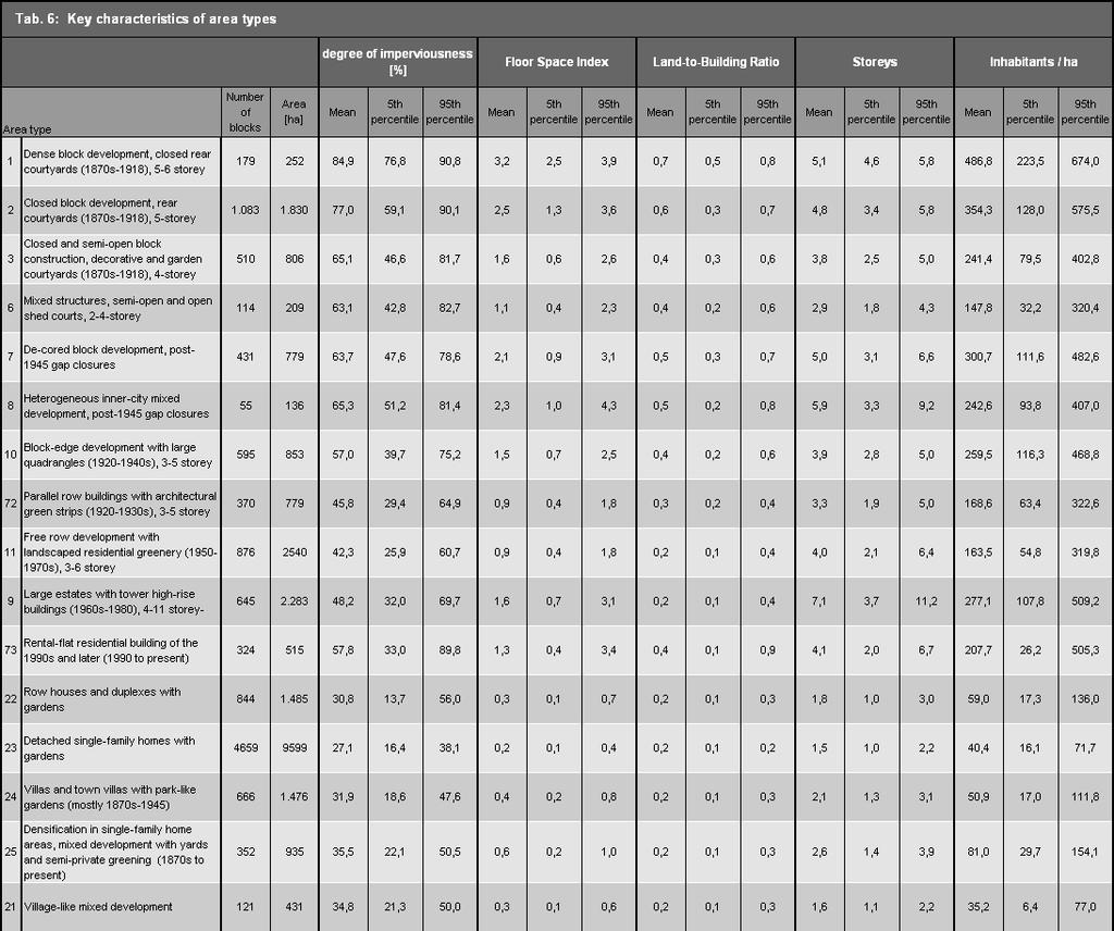
16 the number of inhabitants per ha. These quanta are the factual data available in the data bases which are regularly generated in the City and Environment Information System, with the block map as the spatial reference. The statements contained in the brief descriptions were calculated according to the current use maps by statistical evaluation. In order to ascertain the range, the lower limit was given as the 5 th percentile, and the upper limit as the 95 th percentile, in order to avoid including atypical outliers. In exceptional cases, there are indeed therefore sections which fall outside these characteristic ranges (10% of sections). In the context of the revision, automated plausibility checks were carried out on the basis of key characteristics, and exceptional sections were visually examined. For the statistical evaluation, only those sections could be used the geometry of which had not been changed with respect to ISU For the new areas, the necessary data were not yet available. The following table shows the key values ascertained by statistical evaluation for a selection of section types (section types of Groups I through III). For example, it shows that the dense block construction with closed courtyards is the most densely inhabited section type, with an average resident density of 487 inh./ha. The high use intensity of core areas can be seen from the high average floor space indices. A differentiated definition and description of section types can be seen in the report on the documentation of mapping units and the updating of the database. There, the particular section types are described in detail. Fig. 2: Representation of a single section type (example) from the report on the documentation of mapping units and the updating of the data base 16

17 17
18 Fig. 3: Evaluation of key characteristics for selected section types, inhabitants/ha as of: December 31, 2010; population data as of: December 31,
19 19 Fig. 4: Evaluation of key characteristics for selected section types, Land-to-Building Ratio as of: December 31, 2010, LBR data as of: December 31, 2008

20 Grouping by structure types In Environmental Atlas Map 06.07, similar section types are grouped into a total of 16 overarching structure types: 20
21 21 The representation of the structure types is concentrated, even more than that for the section types, on areas with primarily residential use. The 17 differentiated section types with primarily residential use are grouped into 11 structure types with such use, while the other 35 section types with other uses are grouped into the five remaining structure types. The 11 structure types with primarily residential use our differentiated on the basis of the structure of their buildings and open spaces, and of their building age. Tab. 8 Description of structure types with predominately residential use Structure type Building structure and age Open-space structure (1) Imperial-era block development with wings/ rear buildings (2) Imperial-era blockedge development with few wings/rear buildings (3) Imperial-era blockedge development with major changes (4) Block-edge and row development of 20s & 30s (5) Row development since the 50s (6) Post-war high-rise development (8) Residential development of the 90s (10) Low buildings with yards (11) Villa development with park-like gardens (12) Development with yards and semiprivate green fringes (13) Village-like development 5-6 storeys, closed or almost closed blockedge, front building, wings, rear building(s); built Usually 4 storeys, some lower, largely closed block-edge, front building, either wings or rear building, some 1-2 storey sheds, mostly built , some later 5 to 6 storeys, largely closed block-edge, older imperial-era buildings at the block-edge, mixed with many newer buildings; built after 1945, some older 3-4 storeys, large quadrangles with almost closed block-edge or parallel row development, with open block-edge Mostly 4 storeys, house rows either parallel, staggered arrangement along curved streets, or in chain or spider-web form Usually 4-6 storeys, row development or mixed block-edge and row development with concrete plate construction; interspersed with tower or rectangular high-rises in open arrangement within the block, with more than 6 storeys; mostly built storeys, block-edge development, row development, town-villa estates and townhouses, compact development; built since the early 90s 1 to 2 storeys, single-family homes and duplexes, row houses, smaller rental-flat buildings, weekend cottages and scattered workshops; older developments around blockedges, the more recent along spur streets and access paths into the block interiors; built since early 20 th century. 1-3 storeys; large rental-flat buildings between single-family homes with villas; built since 1950 Mostly 2-storey; block-edge development with villas, rental villas and country homes, large building volumes; built Mostly 2-storey; mixture of new buildings and farmhouses, also buildings in the former village cores Angled interior block spaces, narrow, largely impervious courtyards, often with small flower beds and/or single trees Jagged shaped or longitudinal interior block spaces divided by fences or separated into small segments by walls and sheds; usually with front yard and landscape or commercially used and hence impervious courtyards Block interior spaces divided by fences, walls or the wings or rear buildings, fairly large courtyards, as garden courts, storage spaces or car parks, often with a little greenery, or contiguous interior space, with pathways, playgrounds, with lawns and shrubbery as leisure areas for inhabitants Contiguous block interior spaces or subdivided block sections with longitudinal open space; with decorative lawns and scattered trees and hedges along the houses, play area and waste bin locations. Subdivided block sections with longitudinal free spaces; with parking spaces and play areas, as well as entry path-ways an decorative lawns with scattered trees and bushes Usually open structured but not enclosed block section; contiguous block interiors place only in case of block-edge development; with geometrical, broad entry pathways and parking spaces, as well as decorative lawns and shrubbery Block interior space either continuous or broken down by rows of houses or single villas; open free space with entry pathways and parking spaces, with decorative lawn, shrubbery and single trees Continuous interior block space, separated by fences on lot boundaries; in older estates, subdivided into longitudinal free spaces separated by fences and lot boundaries; decorative or vegetable gardens or orchards Subdivided interior block spaces; with mixture of decorative lawns and shrubbery around flats, and park-like gardens or decorative or vegetable gardens or orchards. Front yard; contiguous interior block spaces separated by fences and lot boundaries; with park-like gardens with old trees on lawns Village-like elements include layout of streets, village greens, village pond, manor parks, cemeteries around churches at least discernible; spaces with gardens, garden cafés, storage spaces for commercial and trade businesses This differentiated perspective has repeatedly proven to be effective. For example, the urban structure mapping system was taken as a secondary data source for the overall city biotope mapping process, and the description of the structure types on the basis of the structures of the buildings and free spaces has largely been adopted for the descriptions of the biotopes in built-up areas.

22 Distribution of structure types in Berlin The 11 structure types of primarily residential use occupy approx. half of the built-up areas of Berlin. The category Low buildings with yards occupies 46%, by far the largest portion of residential areas, followed by Row development since the 50s, with 10%. Village-like development and Residential development of the 90s have the lowest shares of the area, with 2% each (cf. Fig. 5). Fig. 5: Shares of structure types with primarily residential use of the total area of Berlin with primarily residential use, or mixed use with residential character, Area sizes based on block segment map ISU 5 The distribution of the urban structure types within the Berlin boroughs shows the different urban development character of these boroughs (cf. Fig. 6). 22

23 23 Fig. 6: Shares of structure types with primarily residential use of the total area of the Berlin boroughs, and of the entire city, in per cent In Mitte and Friedrichshain-Kreuzberg, a relatively high proportion of imperial-era block development has been preserved, amounting to between two thirds and three quarters of the residential area; in some cases however it has been considerably changed. In the other boroughs, that share is considerably less; citywide, the average of buildings from that era is only 15%. In Marzahn- Hellersdorf, both the share of imperial-era block development and that of row development is vanishingly small. The largest share of row development occurs in Tempelhof-Schöneberg, followed by Charlottenburg-Wilmersdorf and Neukölln. The high share of development of the post-war era accounts for an above-average share in the boroughs of Lichtenberg (40 %) and Marzahn-Hellersdorf (26 %). Low buildings with garden structures are absent in the inner-city borough of Friedrichshain- Kreuzberg, but account for approx. two thirds to three quarters of the residential area in the boroughs on the edge of the city, Steglitz-Zehlendorf, Treptow-Köpenick, Marzahn-Hellersdorf and Reinickendorf. Closed Imperial-era block development with wings and rear houses which have hardly changed since they were built can be found in parts of Charlottenburg and Wilmersdorf, between Lietzensee (Lake), Kurfürstendamm, Richard-Wagner-Straße and Spandauer Damm. In Moabit, Wedding and in Friedrichshain between the Circle Line and Petersburger Straße, along Warschauer Straße, and also in Kreuzberg, Neukölln and Schöneberg between the axes Neukölln Shipping Canal/Skalitzer Straße/Gitschiner Straße, Karl-Marx-Straße/Gneisenaustraße/Yorckstraße, and Potsdamer Straße/Hauptstraße, the dense development with typical rear courtyard structures have largely been preserved. The Imperial-era block-edge development with few wings/rear buildings, which includes the section types Decorative and garden courtyards and Shed courtyards, can be found in the former suburbs of Berlin outside the Circle Line. These building structures, too, have hardly been changed since they were built. Large such areas exist in Friedenau, in Steglitz, in Tempelhof and Friedrichshagen, in Oberschöneweide, Karlshorst, Pankow, Niederschönhausen, and Spandau, and in Reinickendorf west of Provinzstraße.
06.07 Urban Structure Urban Structure Area Types Differentiated (2016 Edition)
") 06.07 Urban Structure 06.08 Urban Structure Area Types Differentiated (2016 Edition) Overview The effects of urban development upon the environment depend to a particular degree on the type and intensity
06.07 Urban Structure 06.08 Urban Structure Area Types Differentiated (2016 Edition) Overview The effects of urban development upon the environment depend to a particular degree on the type and intensity
5.0 VILLAGE AREAS. February 2008 Municipality of West Elgin ~ Official Plan 5-1
 5.0 VILLAGE AREAS This section of the Official Plan deals with the villages of Rodney and West Lorne being the two largest and only fully serviced settlement areas in West Elgin and the most logical and
Chapter 1 - General Design Guidelines CHAPTER 1 GENERAL DESIGN GUIDELINES
 CHAPTER 1 GENERAL DESIGN GUIDELINES 1.0 INTRODUCTION This Publication has been developed to provide current, uniform procedures and guidelines for the application and design of safe, convenient, efficient
01.02 Impervious Soil Coverage (Sealing of Soil Surface) (Edition 2012)
 (Edition 2012)") Senate Department for Urban Development and the Environment 01.02 Impervious Soil Coverage (Sealing of Soil Surface) (Edition 2012) Overview Data on impervious soil coverage are regularly used in the offices
Senate Department for Urban Development and the Environment 01.02 Impervious Soil Coverage (Sealing of Soil Surface) (Edition 2012) Overview Data on impervious soil coverage are regularly used in the offices
ENVIRONMENTAL AND LANDSCAPE MAPPING
 APPENDIX IV : Environmental and Landscape Mapping ENVIRONMENTAL AND LANDSCAPE MAPPING Calveley Neighbourhood Plan November 2016 ENVIRONMENTAL AND LANDSCAPE MAPPING Calveley Neighbourhood Plan Calveley
E. RURAL COMMERCIAL/INDUSTRIAL PARK MODEL
 E. RURAL COMMERCIAL/INDUSTRIAL PARK MODEL 1. PURPOSE The purpose of the Rural Commerce/Industrial Park Model is to provide parameters within which a grouping of business buildings with parking, loading
Environmental and Landscape Mapping
 Environmental and Landscape Mapping In support of the Calveley Neighbourhood Plan November 2016 Project Name and Number: Calveley Neighbourhood Plan 16-025 Document Name and Revision: Environmental and
B L A C K D I A M O N D D E S I G N G U I D E L I N E S for Multi-family Development
 B L A C K D I A M O N D D E S I G N G U I D E L I N E S for Multi-family Development Adopted June 18, 2009 This section of the Design and focuses on site planning and design guidance for new multi-family
01.02 Impervious Soil Coverage (Sealing of Soil Surface) (Edition 2007)
 (Edition 2007)") Senate Department for Urban Development 01.02 Impervious Soil Coverage (Sealing of Soil Surface) (Edition 2007) Overview Data on impervious soil coverage are regularly used in the offices of the Berlin
Senate Department for Urban Development 01.02 Impervious Soil Coverage (Sealing of Soil Surface) (Edition 2007) Overview Data on impervious soil coverage are regularly used in the offices of the Berlin
CONTENTS 8.0 LAND USE 8.1 GENERAL LAND USE 8.2 RESIDENTIAL 8.3 MIXED USE 8.4 COMMERCIAL 8.5 EMPLOYMENT LANDS
 8-2 Land Use 8.0 LAND USE CONTENTS 8.1 GENERAL LAND USE 8.1.1 Uses provided for in all Land Use Designations 8.1.2 Uses prohibited in Hazardous Lands, Hazardous Sites and Special Policy Areas 8.1.3 Uses
6 PORT SYDNEY SETTLEMENT AREA
 Section 6 Port Sydney Page 61 6 PORT SYDNEY SETTLEMENT AREA 6.1 Basis and Principles Village of Port Sydney Waterfront Community Existing Services 6.1.1 Port Sydney is an historic settlement that has developed
Urban planning and Public Transport
 Urban planning and Public Transport MOJCA SASEK DIVJAK Urban Planning Institute of the Republic of Slovenia Trnovski pristan 2, 1000 Ljubljana SLOVENIA e-mail: mojca.sasek@uirs.si; http://www.uirs.si Abstract:
NATIONAL REGISTER OF HISTORIC PLACES MULTIPLE PROPERTY DOCUMENTATION FORM CONTINUATION SHEET ASSOCIATED PROPERTY TYPES
 Section F, Page 1 ASSOCIATED PROPERTY TYPES Six common property types are identified with the 48 cemeteries surveyed in the Town of Southampton. These six property types are identified as being associated
URBAN DESIGN BRIEF. 2136&2148 Trafalgar Road. Town of Oakville
 URBAN DESIGN BRIEF 2136&2148 Trafalgar Road Town of Oakville Prepared By: METROPOLITAN CONSULTING INC For 2500674 Ontario Inc November 2016 TABLE OF CONTENTS Page No. 1.0 Introduction/Description of Subject
Toddington Central Bedfordshire Stage 3 Green Belt Study December 2017
 Toddington Central Bedfordshire Stage 3 Green Belt Study December 2017 Site: ALP086 - Middle Lakes, Toddington Site size (ha): 2.83 Site: ALP086 - Middle Lakes, Toddington Site size (ha): 2.83 Site description
Metro. Activity Center Design Guidelines. Recommendations For Developing Focused, Mixed-Use Commercial/Residential Centers
 Metro Activity Center Design Guidelines Recommendations For Developing Focused, Mixed-Use Commercial/Residential Centers Metro Activity Centers What is a MAC? Legacy, the adopted guide for the future growth
Regency Developments. Urban Design Brief. Holyrood DC2 Rezoning
 Regency Developments Urban Design Brief Holyrood DC2 Rezoning Stantec Consulting Ltd. 7-31-2017 1. Overview Regency Developments intends to rezone the lands located at 8510 and 8511 93 Avenue, within the
Analysis of Environs of 1000 New York Street, German Methodist Episcopal Church
 Item No. 3: L-14-00028 p.1 Analysis of Environs of New York Street, German Methodist Episcopal Church Step One Historical Significance and Context According to the application for Historic Landmark Designation,
Colchester Northern Gateway Master Plan Vision Review Draft. July 2016
 Colchester Northern Gateway Master Plan Vision Review Draft July 2016 Contents Introduction 4 Context 8 Purpose of the Report 8 Strategic Position 9 Overview of the Process 11 2012 Master Plan Vision 12
KEY MAP DEVELOPMENT PERMIT AREA MAP. Sunnymede North Sub-Area Plan
 Richmond Official Community Plan BROADMOOR AREA SUNNYMEDE NORTH SUB-AREA PLAN Bylaw 7100 Schedule 2.6C SUNNYMEDE NORTH SUB-AREA PLAN SUNNYMEDE NORTH SUB-AREA PLAN SUNNYMEDE NORTH SUB-AREA PLAN KEY MAP
Highland Village Green Design Guidelines
 Highland Village Green Design Guidelines Publishing Information Title Highland Village Green Design Guidelins Author The City of Calgary Status DRAFT - Proposed document subject to changes Additional Copies
4.0 Design Guidelines For The Village Centre. South fields Community Architectural Design Guidelines Town of Caledon
 4.0 Design Guidelines For The Village Centre 4.0 Design Guidelines for the Village Centre The Village Centre is the focal point of the entire South Fields Community and is designed as a traditional commercial
Land Use. Chapter 8: Introduction. Land Use Vision. Section I: Current Land Use 8-1
 Introduction Land use is the defining element of the comprehensive plan. It will serve as a framework for decision makers, guiding future growth and development in the Town of Oconto Falls. This chapter
4 RESIDENTIAL ZONE. 4.1 Background
 4 RESIDENTIAL ZONE 4.1 Background The residential areas within the City are characterised by mainly lowrise dwellings sited on individual allotments. Past architectural styles, settlement patterns and
FORMER CANADIAN FORCES BASE (CFB) ROCKCLIFFE SECONDARY PLAN. Official Plan Amendment XX to the Official Plan for the City of Ottawa
 ROCKCLIFFE SECONDARY PLAN. Official Plan Amendment XX to the Official Plan for the City of Ottawa") FORMER CANADIAN FORCES BASE (CFB) ROCKCLIFFE SECONDARY PLAN Official Plan Amendment XX to the Official Plan for the City of Ottawa 1 INDEX THE STATEMENT OF COMPONENTS PART A THE PREAMBLE PAGE Purpose...
FORMER CANADIAN FORCES BASE (CFB) ROCKCLIFFE SECONDARY PLAN Official Plan Amendment XX to the Official Plan for the City of Ottawa 1 INDEX THE STATEMENT OF COMPONENTS PART A THE PREAMBLE PAGE Purpose...
National Character Area 70 Melbourne Parklands
 Summary The are a landscape of rolling farmland, parkland and woodland on the northern flanks of the ridge between Burton upon Trent and Swadlincote. The land slopes down to the River Trent, which borders
PLANNED UNIT DEVELOPMENT & SUBDIVISION STAFF REPORT Date: May 18, 2017
 & PUD-0000102-2017 PLANNED UNIT DEVELOPMENT & SUBDIVISION STAFF REPORT Date: May 18, 2017 NAME SUBDIVISION NAME Dauphin Creek Estates Subdivision Dauphin Creek Estates Subdivision LOCATION CITY COUNCIL
6 Site Framework Strategies
 6 Site Framework Strategies 6.1 Introduction Section 6 identifies a number of specific areas which are considered to be key sites within the Plan area and which may have potential for development / redevelopment.
4 Residential and Urban Living Zones
 4 Residential and Urban Living Zones Refer to Chapters 11 to 20 for additional rules that may apply to these zones. 4.1 OBJECTIVES AND POLICIES Objective Res1 Policy 1 Policy 2 Policy 3 Policy 4 Policy
Tazewell Pike. Neighborhood Conservation Overlay District Design Guidelines
 Tazewell Pike Neighborhood Conservation Overlay District Design Guidelines Knoxville Knox County Metropolitan Planning Commission November 2, 2000 These design guidelines were: Adopted by the Knoxville
5.1 Site Plan Guidelines
 5. Community Core Guidelines Development of the Community Core will take place by plan of subdivision and site plan approval. It will occur in a phased manner that will reflect the timing of residential
Section 9 NEIGHBORHOOD DESIGN
 Section 9 NEIGHBORHOOD DESIGN City of Lancaster Comprehensive Plan D u n k i n, S e f k o & A s s o c i a t e s, I n c. NEIGHBORHOOD DESIGN INTRODUCTION There are many ways in which a neighborhood can
Final Master Plan and Development Control Regulations
 1. INTRODUCTION CHECK LIST a. Introduction b. Table of contents c. Definitions. d. scope of works. 2. FINAL OVERALL MASTER PLAN a. SITE ANALYSIS and OVERVIEW: i. Existing and Proposed Site Plan Levels.
Infill Residential Design Guidelines
 Infill Residential Design Guidelines Adopted March 23, 2004 Amended September 10, 2013 City of Orange Community Development Department Planning Division Phone: (714) 744-7220 Fax: (714) 744-7222 www.cityoforange.org
3.10 LAND USE SETTING PROJECT SITE EXISTING LAND USE DESIGNATIONS AND ZONING. General Plan Land Use Designations.
 This section of the Draft EIR addresses the existing land uses on and adjacent to the project site and discusses the potential impacts of the proposed project on existing land uses. Key issues addressed
6.0 Land Use Policies for Rural Settlements. 6.1 Rural Settlement Strategy
 6.0 Land Use Policies for Rural Settlements 6.1 Rural Settlement Strategy INTRODUCTION AMENDMENT NO. 131 PURPOSE Designated rural settlements comprise Rural Clusters, Villages and Serviced Villages as
429 Lansdowne Road Building or Property Name. Original owner
 HERITAGE SURVEY AND EVALUATION FORM Municipal Address 429 Lansdowne Road Building or Property Name 042280293 Legal Description PLAN 92 PT BLK 13 JUNC GORE;PT LOT 1 RP4R8942 PART 1 Lot Block Plan Date of
LOW DENSITY RESIDENTIAL
 LOW DENSITY RESIDENTIAL Corner lots with coach houses to increase diversity, provide unity to the streetscape and increase eyes on the street. Garages and ancillary units accessed via rear lanes. Parking
SECTION UNIFIED DEVELOPMENT ORDINANCE SECTION Part 1 Ordinance. ARTICLE 1 Zoning Districts
 SECTION 1-100 UNIFIED DEVELOPMENT ORDINANCE SECTION 1-300 Part 1 Ordinance SECTION 1-100. Introduction. ARTICLE 1 Zoning Districts Crystal Lake strives to maintain a balance of various land uses for a
13. London Bridge London Bridge Area Vision
 13. 13.1. Area Vision 13.1.1. is: A globally significant central London business district which is home to international business headquarters; Internationally renowned for its prominent riverfront location
Settlement Boundaries Methodology North Northumberland Coast Neighbourhood Plan (August 2016)
") Introduction This background paper sets out a methodology for the definition of settlement boundaries in the North Northumberland Coast Neighbourhood Plan. The neighbourhood plan is planning positively
Introduction This background paper sets out a methodology for the definition of settlement boundaries in the North Northumberland Coast Neighbourhood Plan. The neighbourhood plan is planning positively
Trafalgar Road Corridor Planning Study Open House
 Trafalgar Road Corridor Planning Study Open House June 24, 2013 6:30-8:30 p.m. Oakville & Trafalgar Rooms Overview The Livable Oakville Plan identifies the lands along Trafalgar Road, between the QEW and
M E M O R A N D U M PLANNING AND COMMUNITY DEVELOPMENT DEPARTMENT CITY OF SANTA MONICA PLANNING DIVISION
 M E M O R A N D U M 10-B PLANNING AND COMMUNITY DEVELOPMENT DEPARTMENT CITY OF SANTA MONICA PLANNING DIVISION DATE: April 9, 2018 TO: FROM: SUBJECT: The Honorable Landmarks Commission Planning Staff 133
g) "Minor repair" means repairs dealing primarily with nonstructural portions of the fence, as well as appearance.
 Minor repair means repairs dealing primarily with nonstructural portions of the fence, as well as appearance.") 6.2.4 FENCES, WALLS AND SCREENS: To protect the use and enjoyment of residential property by providing for the passage of air and light; to protect public welfare and safety by providing for the safe movement
6.2.4 FENCES, WALLS AND SCREENS: To protect the use and enjoyment of residential property by providing for the passage of air and light; to protect public welfare and safety by providing for the safe movement
RESIDENTIAL ACTIVITY PERFORMANCE STANDARDS
 Preferred Options Consultation Q&A Sheet RESIDENTIAL ACTIVITY PERFORMANCE STANDARDS What are the key goals for managing the design of residential buildings in the Second Generation Plan (2GP)? The key
GUIDELINES REPLACEMENT HOUSING GUIDELINES LOCATION INTRODUCTION URBAN DESIGN GUIDELINES
 Replacement housing in the former City of North York will be consistent with the following urban design guidelines. They provide a framework for residential re-development in the former City of North York
FLORIN ROAD CORRIDOR Site Plan and Design Review Guidelines Checklist
 FLORIN ROAD CORRIDOR Site Plan and Design Review Guidelines Checklist Applicant s Name: Project Address: Phone: Email: Applicant shall fill out the design guidelines checklist for all guidelines applicable
8 & 10 Donalda Crescent Official Plan & Rezoning Application Final Report
 STAFF REPORT ACTION REQUIRED 8 & 10 Donalda Crescent Official Plan & Rezoning Application Final Report Date: July 26, 2010 To: From: Wards: Reference Number: Scarborough Community Council Director, Community
2.0 AREA PLANS. Lakeside Business District. Lakeside Business District Land Use Categories:
 Lakeside Business District Lakeside Business District Land Use Categories: Campus Commercial Campus Commercial means a mixture of uses which includes corporate offices, office parks, hotels, commercial,
Zoning Code Issues Prioritization
 City of Streetsboro The City of Streetsboro has begun the process of updating its Zoning Code. The new Zoning Code will be based on the recently adopted Comprehensive Plan, which establishes the overall
RIGA LATVIA. KEY FEATURES OF THE CITY Demographic Facts. Urban Figures. Heritage. EXISTING GOVERNANCE MECHANISMS Development and Management Plans
 RIGA LATVIA KEY FEATURES OF THE CITY Demographic Facts around 700.000 inhabitants in the city 1.15 million people in the Riga region Urban Figures the medieval core of the Old Town the 19th century grid
King s College Proposed Private Plan Change 41 Golf Avenue, Otahuhu URBAN DESIGN ASSESSMENT
 King s College Proposed Private Plan Change 41 Golf Avenue, Otahuhu URBAN DESIGN ASSESSMENT CONTENTS 1.0 EXCECUTIVE SUMMARY... 1 2.0 INTRODUCTION... 2 2.1 Purpose of document... 2 2.2 Report structure...
Rural Land Use Designations Kittitas County December 6, 2007 Draft
 KITTITAS COUNTY COMMUNITY DEVELOPMENT SERVICES 411 N. Ruby St., Suite 2, Ellensburg, WA 98926 CDS@CO.KITTITAS.WA.US Office (509) 962-7506 Fax (509) 962-7682 Rural Land Use Designations Kittitas County
Those uses will be allowed which are compatible with these overall objectives. 4. Public and private parks and playgrounds.
 CHAPTER 500. SECTION 503. ZONING STANDARDS A-C AGRICULTURAL DISTRICT 503.1. Purpose The purpose of the A-C Agricultural District is to preserve the rural and open character of various lands within the
POCKET COMMUNITY PLAN
 POCKET COMMUNITY PLAN Part Three : COMMUNITY PLAN AREAS AND SPECIAL STUDY AREAS CONTENTS Community Location... 3-P-3 Community Vision... 3-P-4 Community Profile... 3-P-4 Community Issues... 3-P-6 Land
L 4-1. Heritage Report: Reasons for Heritage Designation. Kodors House. 35 Rosedale Avenue West
 L 4-1 Brampton Heritage Board Date: January 17, 2012 Heritage Report: Reasons for Heritage Designation Kodors House 35 Rosedale Avenue West December 2011 1 L 4-2 Profile of Subject Property Municipal Address
Wide asphalt driveway abutting school property. garage built with incompatible materials, too close to park. incompatible fencing materials
 Wide asphalt driveway abutting school property incompatible fencing materials garage built with incompatible materials, too close to park Lack of plantings as a buffer between private property and open
06.05 Availability of Public, Nearresidential Green Spaces (Edition 2013)
") Senate Department for Urban Development and the Environment 06.05 Availability of Public, Nearresidential Green Spaces (Edition 2013) Overview Densely built-up urban space is characterized by high structural
Senate Department for Urban Development and the Environment 06.05 Availability of Public, Nearresidential Green Spaces (Edition 2013) Overview Densely built-up urban space is characterized by high structural
General Manager, Planning and Development; General Manager, Parks, Recreation and Culture. Proposed Mini-Park and Plaza Designations
 Corporate NO: R106 Report COUNCIL DATE: June 16, 2008 REGULAR COUNCIL TO: Mayor & Council DATE: June 12, 2008 FROM: SUBJECT: General Manager, Planning and Development; General Manager, Parks, Recreation
VEHICULAR AND PEDESTRIAN CIRCULATION
 This perspective sketch communicates the intended character and quality of a proposed streetscape design. Locate benches near a major intersection where people tend to gather. Seating and lighting provide
DESIGN & ACCESS STATEMENT. REVISION A Residential Development, Neon Social Club, Nairn Street, Jarrow.
 DESIGN & ACCESS STATEMENT. REVISION A Residential Development, Neon Social Club, Nairn Street, Jarrow. The following Design & Access Statement is in support of a Full Planning Application for a residential
City of Vaughan Urban Design Guidelines for Infill Development in Established Low-Rise Residential Neighbourhoods
 City of Vaughan Urban Design Guidelines for Infill Development in Established Low-Rise Residential Neighbourhoods DRAFT - September 2016 Contents 1. Introduction 1 2. Policy Context 3 3. Characteristics
THREE-STEP DESIGN PROCESS FOR OPEN SPACE SUBDIVISIONS
 00216106.DOC NMA/RRK 1/30/14 THREE-STEP DESIGN PROCESS FOR OPEN SPACE SUBDIVISIONS Open space subdivisions, sometimes called cluster developments, maintain a significant portion of a development site in
The broad range of permitted and special uses allowed in the district remain, but some descriptions have been clarified.
 Memorandum To: Emily Fultz, AICP City Planner, City of Edwardsville From: Michael Blue, FAICP Principal, Teska Associates Date: January 24, 2019 RE: B-1 Zoning District Update A draft, updated B-1 Central
II. SINGLE FAMILY RESIDENTIAL
 II. SINGLE FAMILY RESIDENTIAL Castle Rock is made up of numerous individually built houses and subdivision tracts that have been developed during the past century. Some of the tracts are diverse in architectural
Chapter PEDESTRIAN COMMERCIAL (PC) ZONING DISTRICT
 ZONING DISTRICT") Chapter 11-17 PEDESTRIAN COMMERCIAL (PC) ZONING DISTRICT Sections: 11-17-01 GENERAL PURPOSE 11-17-02 PERMITTED BUILDING TYPES 11-17-03 USES PERMITTED WITH DESIGN REVIEW 11-17-04 USES PERMITTED BY CONDITIONAL
Chapter 11-17 PEDESTRIAN COMMERCIAL (PC) ZONING DISTRICT Sections: 11-17-01 GENERAL PURPOSE 11-17-02 PERMITTED BUILDING TYPES 11-17-03 USES PERMITTED WITH DESIGN REVIEW 11-17-04 USES PERMITTED BY CONDITIONAL
PROPOSED REDEVELOPMENT OF THE GLEN ABBEY GOLF CLUB. STREETSCAPE DESIGN STUDY (excerpt from the Urban Design Brief) TOWN OF OAKVILLE.
 TOWN OF OAKVILLE.") PROPOSED REDEVELOPMENT OF THE GLEN ABBEY GOLF CLUB STREETSCAPE DESIGN STUDY (excerpt from the Urban Design Brief) TOWN OF OAKVILLE OCTOBER, 2016 for 2.4.2 STREETS Streets are the single largest component
PROPOSED REDEVELOPMENT OF THE GLEN ABBEY GOLF CLUB STREETSCAPE DESIGN STUDY (excerpt from the Urban Design Brief) TOWN OF OAKVILLE OCTOBER, 2016 for 2.4.2 STREETS Streets are the single largest component
Clairtrell Area Context Plan
 Clairtrell Area Context Plan March 2005 Urban Development Services City Planning Contents 1. Introduction... 4 2. Development Structure... 6 2.1 Streets... 7 2.1.1 Sheppard Avenue and Bayview Avenue...
BYLAW C A Bylaw of Rocky View County to amend Land Use Bylaw C
 BYLAW C-7720-2017 A Bylaw of Rocky View County to amend Land Use Bylaw C-4841-97. The Council of Rocky View County enacts as follows: PART 1 TITLE This Bylaw shall be known as Bylaw C-7720-2017. PART 2
58: 1285 Sedgewick Crescent, Rotary Gardens
 1. Description of Property Municipal Address Name (if applicable) Legal Description Location of Property Ownership Access Current Use Existing Designation General Description Priority Level 58: 1285 Sedgewick
Chapter 8: BEACH SOUTH OF ATLANTIC AVENUE NEIGHBORHOOD PLANNING AREA ANALYSIS
 Chapter 8: BEACH SOUTH OF ATLANTIC AVENUE NEIGHBORHOOD PLANNING AREA ANALYSIS The Beach South of Atlantic Avenue Neighborhood Planning Area includes the parcels adjacent to S Fletcher Avenue from Atlantic
YONGE STEELES CORRIDOR SECONDARY PLAN. Young + Wright / IBI Group Architects Dillon Consulting Ltd. GHK International (Canada) Ltd.
 Ltd.") PART A: PREAMBLE 1.0 PURPOSE The purpose of this Secondary Plan is to provide a development framework for intensification of the Yonge/ Steeles corridor including the north side of Steeles Avenue West
PART A: PREAMBLE 1.0 PURPOSE The purpose of this Secondary Plan is to provide a development framework for intensification of the Yonge/ Steeles corridor including the north side of Steeles Avenue West
Duplex Design Guidelines
 Duplex Design Guidelines Adopted by Council May 29, 2006 Prepared By: Table of Contents 1.0 Application and Intent 1 2.0 Areas of Application 2 3.0 Design Principles 3 4.0 Design Guidelines 4 4.1 Site
The Urban Environment
 9 The Urban Environment Overview of Chapter 9 Population and Urbanization Characteristics of Urban Population Urbanization Trends City as an Ecosystem Environmental Problems in Urban Areas Environmental
for THE PADDOCKS ON JARVIS CREEK
 ARCHITECTURAL GUIDELINES for THE PADDOCKS ON JARVIS CREEK BEAUFORT COUNTY S O U T H C A R O L I N A design guidelines FOR JARVIS CREEK DEVELOPMENT General Design control within Jarvis Creek Development
Covenant Design Review Committee Supplemental Design Criteria
 Covenant Design Review Committee Supplemental Design Criteria FENCESandWALLS ne of the defining characteristics of Rancho Santa Fe is the open character of its landscape. The Ranch s unique appearance
Newcourt Masterplan. November Exeter Local Development Framework
 Newcourt Masterplan November 2010 Exeter Local Development Framework Background The Exeter Core Strategy Proposed Submission sets out the vision, objectives and strategy for the development of Exeter up
SETTLEMENT ASSESSMENT PROFORMA
 SETTLEMENT ASSESSMENT PROFORMA Surveyors(s):Clare Sheridan Character Area: Park Estate = Midland Rd, Severn Rd, Festival Rd, Park Rd, Willow Rd, Rylands Rd. Date: Feb Weather: cloudy Look through all the
CHRISTELER Stéphane URBAN GROWTH WITHOUT SPRAWL: FOUR EXAMPLES IN THE GENEVESE REGION
 CHRISTELER Stéphane URBAN GROWTH WITHOUT SPRAWL: FOUR EXAMPLES IN THE GENEVESE REGION INDEX 1) Issues of urban densification 2) Perceptions of the urban densification 3) The consequences of urban densification
CHAPTER 4 COMMUNITY DEVELOPMENT AND DESIGN
 CHAPTER 4 COMMUNITY DEVELOPMENT AND DESIGN The Community Development and Design Chapter is extremely important because it, together with the Transportation and Circulation Chapter, provides the foundation
Conservation Area Designation, amendments and Review
 Conservation Area Designation, amendments and Review Location: No.s 37-49 (odd) Twickenham Road Date Assessed: January 2018 Adjacent Conservation Area Significance: Teddington Lock CA. The Teddington Lock
ELMVALE ACRES SHOPPING CENTRE MASTER PLAN
 ELMVALE ACRES SHOPPING CENTRE MASTER PLAN Contents 1.0 INTRODUCTION... 2 2.0 LOCATION... 2 3.0 EXISTING CONTEXT... 2 4.0 VISION & GUIDING PRINCIPLES... 2 5.0 LAND USE AND BUILT FORM... 4 5.1 St. Laurent
CHAPTER 5: GUIDING PRINCIPLES
 CHAPTER 5: GUIDING PRINCIPLES The following 10 principles were developed based on public consultation, planning policy and the background analysis conducted during Phase 1. The Guiding Principles significantly
MATURE SUBURBS RESIDENTIAL DEVELOPMENT GUIDELINES
 MATURE SUBURBS RESIDENTIAL DEVELOPMENT GUIDELINES DRAFT FEBRUARY 2005 BIRMINGHAM CITY COUNCIL 1 Introduction Mature Suburbs Residential Development Guidelines - Interim Supplementary Planning Advice -
CLOUGHJORDAN SETTLEMENT PLAN
 CLOUGHJORDAN SETTLEMENT PLAN 1.0 General Introduction and Development Context Location The market town of Cloughjordan lies close to the border with Offaly at the junction of the R490 and R491 Regional
To secure a Green Belt around Cambridge whose boundaries are clearly defined and which will endure for the plan period and beyond.
 4. GREEN BELT OBJECTIVES GB/a GB/b GB/c GB/d To secure a Green Belt around Cambridge whose boundaries are clearly defined and which will endure for the plan period and beyond. To maintain the purposes
GUILDFORD BOROUGH GREEN BELT AND COUNTRYSIDE STUDY
 GUILDFORD BOROUGH GREEN BELT AND COUNTRYSIDE STUDY Volume II - Addendum On behalf of Guildford Borough Council PPG Ref : BNL.0287 April 2014 COPYRIGHT The conents of this document must not be copied or
4780 Eglinton Avenue West - Zoning By-law Amendment and Draft Plan of Subdivision Applications - Preliminary Report
 STAFF REPORT ACTION REQUIRED 4780 Eglinton Avenue West - Zoning By-law Amendment and Draft Plan of Subdivision Applications - Preliminary Report Date: May 29, 2014 To: From: Wards: Reference Number: Etobicoke
Commercial, Retail and Tourism Executive Summary December 2018
 Town of Wasaga Beach Official Plan Review, Retail and Executive Summary December 2018 1 An Official Plan directs where and how to grow The preparation of a new Official Plan for Wasaga Beach is an opportunity
6. Bermondsey 6.1. Bermondsey Area Vision
 6. 6.1. Area Vision 6.1.1. is: An inner-london neighbourhood characterised by modest worker ho associated with the historic Rotherhithe docks and local manufacturing industries such as biscuits, jam, vinegar
APPENDIX 9 HERITAGE CHARACTER
 APPENDIX 9 HERITAGE CHARACTER Defining attributes and features Perth Official Plan Appendix 9 HERITAGE CHARACTER defining attributes and features This appendix includes a table describing heritage attributes
Community Mixed Use Zone Districts (CMU)
") 18.28.500 Community Mixed Use Zone Districts (CMU) The Community Mixed Use Zone Districts (CMU) are intended to help implement the land use goals and strategies found in the Golden Vision 2030 values,
18.28.500 Community Mixed Use Zone Districts (CMU) The Community Mixed Use Zone Districts (CMU) are intended to help implement the land use goals and strategies found in the Golden Vision 2030 values,
BORRISOKANE SETTLEMENT PLAN
 BORRISOKANE SETTLEMENT PLAN 1.0 General Introduction and Development Context Location Borrisokane is located 15km north of Nenagh on the N52. While the town is primarily residential, it acts as a market
Policies and Code Intent Sections Related to Town Center
 Policies and Code Intent Sections Related to Town Center The Town Center Vision is scattered throughout the Comprehensive Plan, development code and the 1994 Town Center Plan. What follows are sections
ACUPUNCTURAL ARCHITECTURE IN BURAIL
 ACUPUNCTURAL ARCHITECTURE IN BURAIL ADDITIONAL BOOKLET 2013 / 2014 Naisa Al Kailany, Mania Bien, Floor Brinks, Hans Kalkhoven REFLECTION GENERAL INFORMATION BURAIL Area of the Plot Permanent cluster 400
599 Kennedy Road - Official Plan Amendment and Zoning Amendment Application - Preliminary Report
 STAFF REPORT ACTION REQUIRED 599 Kennedy Road - Official Plan Amendment and Zoning Amendment Application - Preliminary Report Date: March 7, 2017 To: From: Wards: Reference Number: Scarborough Community
Chapter 10 The Urban World
 Chapter 10 The Urban World Overview of Chapter 10 Population and Urbanization Characteristics of Urban Population Urbanization Trends City as an Ecosystem Environmental Problems in Urban Areas Environmental
Former Rockcliffe Airbase Community Design Plan Guiding Design Vision and Principles December 4, 2013
 APPENDIX 5 - Guiding Design Vision and Principles Former Rockcliffe Airbase Community Design Plan Guiding Design Vision and Principles December 4, 2013 Vision Statement The redevelopment of the former
City of Kingston. North King s Town Secondary Plan Open House + Workshop #1 February 28, 2018
 City of Kingston North King s Town Secondary Plan Open House + Workshop #1 February 28, 2018 1 event agenda 30 min Panel Review + Discussion 30 min Presentation + Q&A 75 min Workshop Session 15 min Report
Stowford Mill, Ivybridge Introduction
 Stowford Mill, Ivybridge Introduction 1. What is the purpose of this exhibition? Burrington Estates would like residents and interested parties to have the opportunity to review updated proposals for the