CITY OF VAUGHAN EXTRACT FROM COUNCIL MEETING MINUTES OF DECEMBER 10, 2013
|
|
|
- Alexandra Carter
- 5 years ago
- Views:
Transcription
1 CITY OF VAUGHAN EXTRACT FROM COUNCIL MEETING MINUTES OF DECEMBER 10, 2013 Item 1, Report No. 55, of the Committee of the Whole (Working Session), which was adopted without amendment by the Council of the City of Vaughan on December 10, Regional Councillor Di Biase declared an interest with respect to the foregoing matter insofar as it relates to Block 27, as his children own land in Block 27 given to them by their maternal Grandfather and did not take part in the discussion or vote on the matter. 1 NATURAL HERITAGE NETWORK INVENTORY AND IMPROVEMENTS PHASES 2 TO 4 UPDATE REPORT FILE NO The Committee of the Whole (Working Session) recommends: 1) That the recommendation contained in the following report of the Commissioner of Planning, dated December 3, 2013, be approved; 2) That the following deputations and communication be received: 1. Mr. Sony Rai, Vaughan Mills Road, Vaughan; 2. Mr. Mark Inglis, Main Street, Kleinburg; 3. Mr. Jamie Maynard, William Street, Woodbridge; 4. Ms. Gloria Marsh, York Region Environmental Alliance; and 5. Mr. Gerry Lynch, Cole Engineering Group, on behalf of Block 27 Landowners Group and Communication C2; and 3) That Communication C1, presentation material, entitled, Natural Heritage Network, be received. Regional Councillor Di Biase declared an interest with respect to the foregoing matter insofar as it relates to Block 27, as his children own land in Block 27 given to them by their maternal Grandfather and did not take part in the discussion or vote on the matter. Recommendation The Commissioner of Planning recommends: 1. THAT the presentation and staff report, which provides an update on the progress of the Natural Heritage Network Study, BE RECEIVED for input and discussion. Contribution to Sustainability The Vaughan Official Plan (VOP 2010) was adopted by Council on September 7, 2010 and was subject to further Council modifications on September 27, 2011, March 20, 2012 and April 17, 2012 and was endorsed by York Region Council on June 28, VOP 2010 designates a natural heritage system, the Natural Heritage Network, which is delineated on Schedule 2. Environmental policies in Chapter 3 of VOP 2010 direct that appropriate studies be undertaken to determine the precise limits of natural heritage features and any additions to the mapped network. The Plan is consistent with York Region Official Plan policies directing local municipalities to develop local greenlands systems. Two specific action items in Green Directions Vaughan (2009), the City s Community Sustainability and Environmental Master Plan, relate to the need to complete a natural heritage system. /2
2 CITY OF VAUGHAN EXTRACT FROM COUNCIL MEETING MINUTES OF DECEMBER 10, 2013 Item 1, CW(WS) Report No. 55 Page Through the development of the City s new Official Plan, and in partnership with the Toronto and Region Conservation Authority, ensure protection of remaining natural features and explore opportunities for habitat restoration in headwater areas, along riparian corridors, and around wetlands Develop a comprehensive Natural Heritage Strategy that examines the City s natural capital and diversity and how best to enhance and connect it. As part of this action: Develop an inventory of Vaughan s natural heritage, and identify opportunities for habitat restoration; Ensure that policies in the City s new Official Plan protect all ecological features and functions as per current provincial and regional policies, and also include consideration for locally significant natural features and functions; Develop policies to create opportunities for near urban agriculture within Vaughan s rural areas, through policies described in the City s new Official Plan. The refinement of the Natural Heritage Network and development of a stewardship strategy in Phases 2 through 4 of the Natural Heritage Network Study fulfill key components of the Green Directions Vaughan plan. Economic Impact Funding for the Natural Heritage Network Study was included in the 2011 Capital Budget (PL ) on the basis of a two part allocation. Phase 1 was treated as a stand-alone project and was funded in the amount of $52,400. In the 2012 Capital budget, the funding for Phases 2, 3, and 4 was approved at $199,700. The total budget for the preparation of the Natural Heritage Network Study is $252,000. Communications Plan A communications plan in respect of this report is not required. A communications and public consultation plan has been prepared as part of the process of conducting Phases 2 to 4 of the Natural Heritage Network Study. A summary of stakeholder and broader public consultation is provided in this staff report. Purpose The purpose of this report is to inform Council of the work completed to date on Phases 2 to 4 of the Natural Heritage Network Study. This staff report marks the completion of Phase 2 and one round of consultation. The consulting team will integrate the information generated to date to inform updated ecosystem targets and prepare NHN scenarios in preparation of the next round of consultation. This will take place in the first quarter of 2014 with the draft and final reports being presented in the second quarter of Background - Analysis and Options The Policy and Planning Context A rigorous Provincial and Regional policy framework directs the maintenance, restoration or improvement of the diversity and connectivity of natural features and the long-term ecological function and biodiversity of natural heritage systems in the Greater Toronto Area. This policy framework is reflected in the environmental policies of VOP The following policy documents were consulted in the preparation of the environmental policies of VOP 2010 and the Terms of Reference for Phase 1 and Phases 2 to 4 of the Natural Heritage Network Study: /3
3 CITY OF VAUGHAN EXTRACT FROM COUNCIL MEETING MINUTES OF DECEMBER 10, 2013 Item 1, CW(WS) Report No. 55 Page 3 the Growth Plan for the Greater Golden Horseshoe (2006); the Provincial Policy Statement (2005) and the Natural Heritage Reference Manual - Second Edition (2010); the Greenbelt Plan (2005); the Oak Ridges Moraine Conservation Plan (2002); the Endangered Species Act (2007); the Ontario Biodiversity Strategy, 2011; the York Region Official Plan (2010); and Ontario Regulation 166/06 under the Conservation Authorities Act. i) Provincial Policies The Growth Plan for the Greater Golden Horseshoe Places to Grow The Province of Ontario approved the Growth Plan for the Greater Golden Horseshoe (GGH) - Places to Grow in The Growth Plan sets out a vision for growth in the GGH to the year This includes a set of long-range growth forecasts and directing how growth should be accommodated and managed effectively. The Growth Plan supports the role of municipal policy in providing leadership and innovation in developing a culture of conservation. The Growth Plan also encourages planning authorities to identify natural heritage features and areas that complement, link, or enhance natural systems. Municipalities are encouraged to develop a system of publicly accessible parkland, open space and trails embedded in a natural heritage system as well as establish an urban open space system within built-up areas, which include rooftop gardens, communal courtyards, and public parks. The Provincial Policy Statement The Provincial Policy Statement (PPS) has a strong focus on the long-term prosperity and environmental health of Ontario. It states that natural features and areas shall be protected for the long-term (2.1.1). The PPS defines natural features and areas as: features and areas, including significant wetlands, significant coastal wetlands, fish habitat, significant woodlands south and east of the Canadian Shield, significant valley lands south and east of the Canadian Shield, significant habitat of endangered species and threatened species, significant wildlife habitat, and significant areas of natural and scientific interest, which are important for their environmental and social values as a legacy of the natural landscapes of an area. The PPS also defines natural heritage system as: A system made up of natural heritage features and areas, linked by natural corridors which are necessary to maintain biological and geological diversity, natural functions, viable populations of indigenous species and ecosystems. These systems can include lands that have been restored and areas with the potential to be restored to a natural state. The Greenbelt Plan The Greenbelt Plan contains policies for providing permanent agricultural and environmental protection as well as providing for a wide range of recreation, tourism and cultural opportunities in the area. The Protected Countryside comprises an Agricultural System and a Natural System, together with a number of settlement areas and is intended to improve /4
4 CITY OF VAUGHAN EXTRACT FROM COUNCIL MEETING MINUTES OF DECEMBER 10, 2013 Item 1, CW(WS) Report No. 55 Page 4 linkages between these areas and surrounding systems. The Natural System identifies lands that support both natural heritage and hydrologic features and functions. The Greenbelt Plan recognizes that the Natural System extends beyond the boundaries of the Greenbelt and encourages connections between the Greenbelt s Natural System and the broader scale natural heritage systems of southern Ontario. Criteria have been defined to permit potential municipal requests to expand the Greenbelt. The Oak Ridges Moraine Conservation Plan The Oak Ridges Moraine Conservation Plan (ORMCP) is a fundamental component of the Greenbelt Plan. The Oak Ridges Moraine is an environmentally sensitive, geological landform located in south central Ontario, covering 190,000 ha. It has a unique concentration of environmental, geological and hydrological features that make its ecosystem vital to southcentral Ontario. The ORMCP identifies four categories of land use: Settlement; Countryside; Natural Linkage; and Natural Core. The latter two designations are the most restrictive, and provide the most aggressive goals for the protection of natural heritage. Endangered Species Act The new Endangered Species Act (2007) is the first in Canada to combine mandatory habitat protection with a science-based approach to listing species for protection. Species thought to be at risk are assessed by The Committee on the Status of Species at Risk in Ontario (COSSARO). COSSARO is an independent body that reviews species based on the best available science, including community knowledge, and Aboriginal Traditional Knowledge. Once species are classified as "at risk", they are added to the Species at Risk in Ontario (SARO) list in one of four categories. Endangered, threatened and extirpated species on this list automatically receive legal protection under the ESA Providing legal protection to threatened species is a change from the original Act which only applied to endangered species. Under the ESA 2007, it is required that direct and indirect habitat of endangered species be protected. Habitat regulations under the Act are available for Redside Dace (Regulation 293/11), which is relevant to the NHN Study in Vaughan. Ontario s Biodiversity Strategy, 2011 Ontario s Biodiversity Strategy, 2011 is the guiding framework for coordinating the conservation of Ontario s variety of life and ecosystems. The success of this Strategy will be tracked through 15 specific targets representing key areas of focus for biodiversity conservation in Ontario. The progress will be monitored and assessed over a 10-year time frame to encourage people across all sectors to take actions that will ultimately lead to securing and maintaining Ontario s biodiversity. Several of the 15 targets refer directly to implementing natural heritage systems for biodiversity conservation, maintaining and enhancing ecosystem services, and reporting on the state of Ontario s biodiversity. ii) York Region Official Plan (YROP) The York Region Official Plan (ROP 2010), approved by the Minister of Municipal Affairs and Housing on September 7, 2010, is the upper tier planning document that provides the framework for achieving the Region s urban structure. The Region s plan was appealed to the Ontario Municipal Board (OMB). A series of modifications have been approved by the OMB and the plan is substantially in effect. Any amendments to the City s Official Plan must conform to the Region s Official Plan. The ROP 2010 recognizes the importance of integrating the objectives of the natural environment with those for healthy communities and economic vitality as outlined in its Sustainability Strategy (2007). The importance of maintaining and enhancing a healthy Regional Greenlands System is emphasized in the ROP /5
5 CITY OF VAUGHAN EXTRACT FROM COUNCIL MEETING MINUTES OF DECEMBER 10, 2013 Item 1, CW(WS) Report No. 55 Page 5 The policy framework has been brought into conformity with the Greenbelt Plan, the Oak Ridges Moraine Conservation Plan, the York Region Significant Woodlands Study (2005) among other important instruments that will affect the outcomes for the Greenlands System. The primary function of the Regional Greenlands System is: the protection of natural heritage features in a system of cores connected by corridors and linkages. The Regional Greenlands System also provides opportunities for passive recreation in a future Regional Trails System such as hiking and nature appreciation. Urban uses and infrastructure projects should contribute ecological gains to the Regional Greenlands System through enhancement and restoration, and the strategic creation of natural habitat. It is the intent that the Vaughan Natural Heritage Network (NHN) and supporting policies be consistent with the objectives identified in the ROP iii) Toronto and Region Conservation Authority Policy and Regulation The province has delegated approval authority to the Toronto and Region Conservation Authority (TRCA) for the Natural Hazard section of the PPS. The TRCA also has a commenting role on development applications submitted to the municipality under the Planning Act for aspects of water resource systems and natural heritage. They rely on four key instruments to guide their comments and permitting: the Terrestrial Natural Heritage System Strategy (2007); watershed plans; the Valley and Stream Corridor Management Program (1994); and Regulation 166/06 under the Conservation Authorities Act. The objective of the TRCA Terrestrial Natural Heritage System (TNHS) is to identify and evaluate natural heritage features and functions in the landscape, for inclusion in a Natural Heritage System. The Humber River Watershed Plan and Don River Watershed Plan describe the TNHS for the respective watersheds and include implementation recommendations regarding land use, outreach and stewardship. Watershed Plans are mandated under the Oak Ridges Moraine Conservation Plan. The Humber River Watershed Plan: Pathways to a Healthy Humber and the Implementation Guide (2008) and the Don River Watershed Plan: Beyond 40 Steps and Implementation Guide (2009) provide guiding principles and objectives that support strategies and targets that include protecting and expanding the terrestrial natural heritage system, building sustainable communities and creating an enhanced regional open space system. The TRCA's Valley and Stream Corridor Management Program outlines policies that seek to retain watercourses and valley and stream corridors as open, natural landforms, from the headwaters to the river estuary marshes. These policies guide the TRCA Planning and Development staff when reviewing applications under Ontario Regulation 166/06 and in commenting on land use planning policy documents and development applications. Ontario Regulation 166/06, Development, Interference with Wetlands and Alterations to Shorelines and Watercourses, is the regulation under Section 28 of the Conservation Authorities Act that is specific to the TRCA. The main objectives of O.R. 166/06 are to ensure public safety and protect property with respect to natural hazards and to safeguard watershed health by preventing pollution and impacts to sensitive environmental areas such as wetlands, shorelines and watercourses. Relation to VOP 2010 and Green Directions Vaughan The overall Natural Heritage Network Study will assess the role of the existing Natural Heritage Network in maintaining elements of biodiversity and ecological functions for the long term, /6
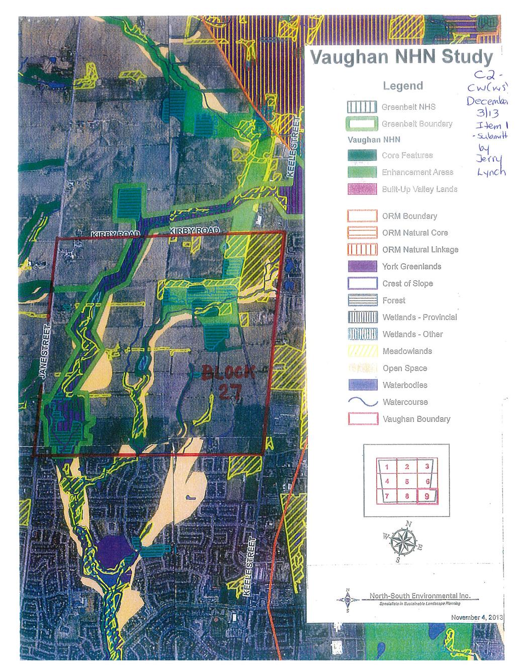
6 CITY OF VAUGHAN EXTRACT FROM COUNCIL MEETING MINUTES OF DECEMBER 10, 2013 Item 1, CW(WS) Report No. 55 Page 6 consistent with Provincial Policy Statement (PPS) At the completion of all phases of the Natural Heritage Network Study, additional NHN areas may be proposed to meet ecosystem targets of the natural heritage system related to biodiversity persistence and ecological function. At the completion of the Natural Heritage Network Study, an amendment to VOP 2010 will be prepared to implement the findings of the Natural Heritage Network Study, which will modify Schedule 2 and relevant policies in section 3.2.3, Components of Vaughan s Natural Heritage Network. Schedules may also be added to delineate natural features according to Section 3.3, Features of the Natural Heritage Network. Protection, restoration and enhancement of natural areas in the City s Natural Heritage Network are aspects of achieving healthy and vibrant communities that is reflected in the City s sustainability strategy, Green Directions Vaughan. While two action items in Green Directions Vaughan specifically address the Natural Heritage Network (Action Items and 2.2.4), related action items address green infrastructure (e.g. treatment train approach to stormwater management and urban forests), recreation and open space, trails and other active transportation paths, and agriculture. The scope of the Natural Heritage Network Study has a clear focus on biodiversity persistence and sustaining key ecological functions. However, the benefits to residents through the provision of ecosystem services (e.g. clean air, clean water, flood protection, carbon sequestration) and the amenity value of the City s existing and restored natural areas extend well beyond the limits of the Natural Heritage Network. Achieving certain key milestones of the NHN Study are also a requirement of initiating the New Community Areas Secondary Plan process. Policy of VOP 2010 requires the following prior to commencement of the New Community Areas Secondary Plan(s): the submission by the landowners within the ROPA 2 amendment area of information in a format and at a level of detail consistent with the TRCA, York Region and City of Vaughan policies; a report to Committee of the Whole and Council on the findings of Phase 1 of the Natural Heritage Network Study; and Council approval of the Terms of Reference for Phases 2-4. These steps have been substantially completed as discussed below. (i) (ii) (iii) Phase 1 of the NHN Study is complete and a staff report summarizing the findings was provided to Committee of the Whole (Working Session) on December 4, Committee of the Whole recommended that a summary of the public consultation component be provided to the January 15, 2013 Committee of the Whole meeting; and Phase 1 was subsequently approved by Council on January 29, The Terms of Reference for Phases 2-4 of the NHN Study was approved by Council on September 25, 2012, and the consulting contract for the corresponding Request for Proposal (RFP) was awarded on January 29, The work plan for Phases 2-4 of the NHN Study has been underway since May 2013 and is expected to be completed in the second quarter of A public consultation strategy is a critical component of the work plan for the Natural Heritage Network Study and includes meetings with landowners and their agents for the individual Blocks to be developed. These meetings are planned as technical sessions in January and February of 2014 to discuss data sharing and data interpretation, all of which is part of the Phase 3 objective to test NHN scenarios against ecosystem targets. The completion of these technical sessions in the first quarter of 2014 is anticipated to satisfy the test of the submission by the landowners within the ROPA 2 amendment area of information in a format and at a level of detail consistent with the TRCA, York Region and City of Vaughan policies. /7
7 CITY OF VAUGHAN EXTRACT FROM COUNCIL MEETING MINUTES OF DECEMBER 10, 2013 Item 1, CW(WS) Report No. 55 Page 7 Update on the Natural Heritage Network Study: Work To-date and Next Steps: Phase 1 of the Natural Heritage Network Study Phase 1 of the NHN Study was completed in November 2012 and a report provided to Committee of the Whole (Working Session) in December The expectations set out in the Terms of Reference for Phase 1 of the NHN Study were met. A comprehensive GIS database was developed and delivered to the City, recommendations to revise the Environmental Management Guideline were provided, and recommendations for field investigations assisted in identifying sample sites and finalizing survey protocols. One of the early findings of the effort to compile a comprehensive GIS database included the identification of data gaps. In particular, recent approvals of some developments have resulted in changes to feature boundaries, but the available environmental information layers show previous land classifications. Many of these situations for woodlands, wetlands and ANSIs have been corrected in Phase 1, but these situations will continue to be identified through review and consultation in Phase 3 of the Study. Such data discrepancies highlight the need for more detailed and refined GIS layers for Vaughan and an appropriate protocol to track changes. The development of NHN targets and an assessment of the NHN against the targets, to understand the biodiversity contribution of existing natural areas, required further work in Phases 2 and 3. The key lesson learned in Phase 1 was the need to undertake spatial modelling of enhancement area options to identify and test NHN targets in an iterative process. This will be the primary task of the consulting team in the coming months. Phases 2 to 4 of the Natural Heritage Network Study Phase 2 Field Investigations Field investigations were undertaken between April 2013 and September As described in the Terms of Reference for the NHN Study, the field investigations were targeted to sampling headwater drainage features (HDF) and lands potentially meeting criteria for Significant Wildlife Habitat as defined in the PPS. Of the 57 HDF sample sites visited in the Spring, 12 were re-visited to sample Summer conditions according to the standards in the Ontario Stream Assessment Protocol and Evaluation, Classification and Management of Headwater Drainage Features Guideline prepared by the Toronto and Region Conservation Authority and Credit Valley Conservation (TRCA 2013). Breeding bird sampling was undertaken targeting open meadow habitat and forest clusters, a total of 50 sites were sampled two times following Breeding Bird Atlas protocols. A total of 71 stations were sampled to assess potential amphibian breeding habitat, sites were sampled following Marsh Monitoring Protocols with each station survey three times. Bluff communities were visited to search for potential colony nesting bird habitat and to look for potential significant plant communities such as prairie. A total of 41 bluff communities were visited. Phase 3 NHN Summary, Recommendations and Reporting Phase 3 is now the main focus of the consulting teams work. NHN scenarios will be developed by integrating the information and input provided through the GIS compilation in Phase 1, the field sampling, and the consultation process. The scenarios will then be tested against ecosystem targets. The results of this iterative analysis will be the focus of the next round of the consultation in late January 2014 to March /8
8 CITY OF VAUGHAN EXTRACT FROM COUNCIL MEETING MINUTES OF DECEMBER 10, 2013 Item 1, CW(WS) Report No. 55 Page 8 Phase 4 Land Securement Strategy The public consultation venues provided the opportunity to introduce a range of land securement options. The focus at this point has been on education of the land securement approaches. The Land Securement Strategy will be developed in tandem with developing the NHN scenarios and will offer input into the NHN scenarios by considering feasibility of land securement options together with ecological criteria when evaluating enhancement and restoration priorities. Public Consultation Strategy The approach to community engagement will ensure that key stakeholder groups, as well as the general public, have an opportunity to participate in the development of Vaughan s NHN. The objectives of the community engagement process are to: Raise awareness about the importance of Vaughan s natural heritage assets to the city s environmental, social and economic well-being; Provide opportunities for both individuals and groups to be engaged in meaningful discussion about the development of Vaughan s NHN; Actively engage and inspire key audiences in the creation of the NHN strategy through the use of innovative tools and techniques; and Inform the development of Vaughan s NHN Study through a collaborative and participatory process. The public consultation approach emphasizes the following key messages. Balancing urban growth and natural heritage conservation is important to Vaughan s longterm development, and can be achieved in part through a NHN. The community engagement process will provide stakeholders and members of the public with the opportunity to participate in the development of Vaughan s NHN. The feedback collected through the engagement process will be used to inform decision-making as the NHN Study progresses. Everyone s voice is important. The City wants to hear from as many people as possible. The following activities have been undertaken. Targeted Stakeholder Meetings Meetings were held with the owners (and their agents) of lands within the planned urban envelope to provide an update on the NHN Study. The main action item from the meetings was to share information and to set the stage for discussion on data interpretation in subsequent technical meetings, which will be held in late January and early February Two stakeholder sessions were held for a range of interested parties including representatives of utilities, agencies, and environmental organizations. A session was also held for internal staff to update the consulting team on related projects, such as for infrastructure, parks and other matters related to asset management. First Nations A letter was sent to the First Nations contacts provided as part of the York Region First Nations and Metis Consultation Draft and the Region s Archaeological Management Plan. The City and consulting team have offered to meet with First Nations in Q1 of 2014 to seek input on the Phase 3 and Phase 4 recommendations of the NHN Study. /9
9 CITY OF VAUGHAN EXTRACT FROM COUNCIL MEETING MINUTES OF DECEMBER 10, 2013 Item 1, CW(WS) Report No. 55 Page 9 Public Meeting (Community Forum) A Public Meeting was held on November 13, 2013 as a joint Community Forum for both the NHN Study and the City s Community Climate Action Plan aimed at reducing community generated greenhouse gas emissions. After introductions and a world café, participants were asked to move to stations to participate in specific discussions. Two stations were set up for the NHN Study: a discussion of ecosystem targets and NHN scenarios facilitated by Brent Tegler of North- South Environmental; and a discussion of land securement mechanisms facilitated by Kate Potter of Orland Conservation. The joint Community Forum, together with provision of an online survey and map products on the City web site in advance of the meeting, was a success in attracting attendees and generating feedback. The City received constructive comments for changes to the materials on the project web site. During the meetings, input and questions ranged in scope from requests to expand the NHN in Vaughan to detailed requests or clarification on methodologies being employed and next steps. Several mapping issues were raised at the meeting and this feedback will be considered in the analysis comprising Phase 3. Interactive Information and Updates Prior to the Community Forum, the following materials were made available on the City s project web site and by notification. Next Steps Newsletter and Notification of Public Meeting An was sent to the broad distribution list established through the Official Plan review process and revised in Phase 1 of the NHN Study with a notification of the Public Meeting and Issue #1 of the NHN Newsletter. Interactive Maps in Adobe Acrobat Format Consistent feedback from the public in Phase 1 of the NHN Study was to provide NHN information such as map products, ideally as interactive data through a Geographic Information System (GIS). While the City is not able to provide interactive GIS data, the consulting team provided maps in Adobe Acrobat format with layers that can be turned off and on. While only a subset of data compiled in Phase 1 could be displayed in the Adobe Acrobat maps, it provides the opportunity for input into setting priorities for modifications to the NHN. Online Survey The online survey has the objective of seeking input from the public about areas of importance and/or priorities for conservation to support the refinement of the NHN. The survey is structured in three parts: Part A seeks input on the broad vision and goals of the NHN; Part B provides illustrative examples of ecosystem targets intended to generate qualitative feedback about specific areas and/or ecological themes of importance; and Part C invites the respondent to stay connected to the process. Twitter Messages Messages sent through the City s Twitter feed were coordinated with the Community Climate Action Plan. Completion of the field sampling season and a major round of consultation mark a significant milestone for the NHN Study. The consulting team will take the information and input provided to date to address the tasks of Phase 3 by developing NHN scenarios to test against ecosystem targets. /10
10 CITY OF VAUGHAN EXTRACT FROM COUNCIL MEETING MINUTES OF DECEMBER 10, 2013 Item 1, CW(WS) Report No. 55 Page 10 Phase 2 Field Investigations The main outstanding task of Phase 2 is to compile the field data and analyze the information together with information provided by landowners and data from other pertinent sources. A particular focus will be the consideration of a cumulative effects approach to assess headwater drainage features. This information will be the subject of future technical meetings with landowners in the parts of the City for planned future development. Phase 3 NHN Summary, Recommendations and Reporting Phase 3 is now the main focus of the consulting team s effort. Information from Phase 1 will be integrated with input provided through field sampling and the consultation process to develop NHN scenarios and test the scenarios against ecosystem targets. The results of this iterative analysis will be the focus of the next round of consultation in late January 2014 to March Phase 4 Land Securement Strategy The Land Securement Strategy will be developed in tandem with developing the NHN scenarios and will offer input into the NHN scenarios by considering feasibility of land securement options together with ecological criteria when evaluating enhancement and restoration priorities. Public Consultation Future rounds of public consultation will focus on the early results of the Phase 2 efforts and include: Technical meetings with landowners and agents, who own land in areas of the City planned for future development, to continue to share information and provide input to the NHN scenarios and ecosystem targets; Targeted stakeholder meetings; A possible meeting(s) with First Nations representatives; and A Public Meeting. The City will circulate at least one additional newsletter and continue to make information available on the project web site, as required. Reporting A draft report and final report will be provided in the second quarter of Relationship to Vaughan Vision 2020/Strategic Plan The Natural Heritage in the City report is consistent with the Vaughan Vision 2020 Strategic plan, through the following initiatives, specifically: Service Excellence: Lead & Promote Environmental Sustainability Management Excellence: Plan and Manage Growth & Economic Vitality Demonstrate Leadership & Promote Effective Governance This report is consistent with the priorities previously set by Council. /11
11 CITY OF VAUGHAN EXTRACT FROM COUNCIL MEETING MINUTES OF DECEMBER 10, 2013 Item 1, CW(WS) Report No. 55 Page 11 Regional Implications Policies in the ROP 2010 support the effort of local municipalities to identify local greenlands systems. Conclusion Phase 2 and a major round of the Natural Heritage Network Study consultation process are now complete. This report outlines the steps leading to the completion of the NHN study, which is anticipated for the second quarter of Therefore it is recommended that this report and the accompanying presentation on the progress of the Natural Heritage Network Study be received for input and discussion. Attachments n/a Report prepared by: Tony Iacobelli, Senior Environmental Planner ext Roy McQuillin, Manager, Policy Planning
12
13 PURPOSE OF THE PRESENTATION Provide an update on the status of the NHN Study; Explain preliminary findings and the approach to refining the NHN; Describe the community engagement process to inform the Study findings; and Explain next steps. 2
14 PROJECT BACKGROUND AND STATUS NHN Phase 1 4 study steps were identified in a June 1 st, 2010 staff report to CW, including the need to identify ecosystem targets and to conduct field work to assess Significant Wildlife Habitat (SWH) and Headwater Drainage Features (HDF); NHN Study providing input to help resolve VOP 2010 OMB appeals; and Provides increased certainty for developers and the City in planning for development (e.g. Secondary Plans, Block Plans). 3
15 PROJECT BACKGROUND AND STATUS Capital Budget request approved by Council in 2010 outlined justification for NHN Study including: meeting Provincial policy and regulatory requirements, particularly ESA (e.g. Redside Dace) conformity to Region policies regarding Greenlands ; understanding impact of the GTA West Corridor; input to Secondary Plans including for New Community Areas; input to the Greenbelt Plan and ORMCP review scheduled for 2015; and an improved NHN database to more efficiently and effectively process development applications. 4
16 CORPORATE BENEFITS Implementing action items in Green Directions Vaughan; Link to IT strategy for electronic data management and GIS; Improved data for better decision-making regarding development approvals and infrastructure requirements; Integrated with the Active Together Master Plan to inform parks development and planning. 5
 consisting of core areas & enhancement areas that")

17 NHN PROJECT GOAL To identify a Natural Heritage Network (NHN) consisting of core areas & enhancement areas that form a robust, linked ecological system of resilient natural habitats providing long term protection of native biodiversity 6
18 NHN PHASE 2 4 STUDY OBJECTIVES There are three main study objectives. Assess ecological features (biodiversity) and ecological functions within the existing NHN Develop a comprehensive GIS database of natural heritage information for environmental planning Prepare a strategy for long term enhancement of the NHN 7
19 NHN PHASE 2 4 STUDY COMPONENTS There are four main study components in the remaining phases: Field Investigations Headwater Drainage Features (HDF) and Significant Wildlife Habitat (SWH) Develop a recommended approach to identify and map a Natural Heritage Network (NHN) for Vaughan Prepare a Land Securement Strategy Develop & implement a Community Engagement Plan 8
20 Field Work Examples 9


21 SAMPLE RESULTS OF HDF FIELD WORK TRCA/CVC Management Recommendation HUM Mitigation HUM Mitigation 10


22 SAMPLE RESULTS OF HDF FIELD WORK TRCA/CVC Management Recommendation HUM 1305 Conservation HUM 1302 Conservation 11

23 SAMPLE RESULTS OF HDF FIELD WORK TRCA/CVC Management Recommendation HUM Mitigation HUM Mitigation 12


24 SAMPLE RESULTS OF HDF FIELD WORK TRCA/CVC Management Recommendation HUM Mitigation? HUM Mitigation? 13


25 SAMPLE RESULTS OF SWH FIELD WORK Open Habitat Breeding Birds in large Meadow Area 14
26 Approach to Mapping NHN 15
27 IDENTIFYING NHN SCENARIOS BASED ON POLICY & REGULATION TARGETS 1. Species at Risk Species Listed under the Endangered Species Act 2. ORM Core Areas & Linkage Areas Key Natural Heritage Features (KNHF) Hydrologically Sensitive Features (HSF) 3. Greenbelt Natural Heritage System Key Natural Heritage Features (KNHF) Key Hydrologic Features (KHF) 4. York Region Greenlands Key Natural Heritage Features (KNHF) & Key Hydrologic Features (KHF) 5. Provincial Policy Statement Significant Habitat of Endangered and Threatened Species Significant Woodlands Significant Valleylands Significant Wildlife Habitat Significant Areas of Natural and Scientific Interest Fish Habitat Adjacent Lands 6. Toronto Region Conservation Regulations Steep Slopes Wetlands Watercourses 16
28 IDENTIFYING NHN SCENARIOS BASED ON SYSTEM TARGETS 1. Enhancement Areas enhancement to create woodland interior enhancement to create core habitat clusters consisting of woodlands, wetlands, open habitat, watercourses, and water bodies enhancement to create regional centres for biodiversity 2. Ecological Linkage regional ecological linkages within and beyond the City of Vaughan local ecological linkages associated with woodlands, wetlands, open habitat and watercourses linkage providing connectivity between aquatic and terrestrial habitat linkage providing connectivity among watersheds multiple linkages providing redundancy of connectivity among features ecopassages where the NHN encounters barriers to wildlife movement (e.g. roads, railines) 3. Buffers provide protection of NHN features from impacts associated with adjacent land uses implement ORM, Greenbelt and York Region Greenlands criteria regarding Vegetation Protection Zones implement TRCA setbacks for wetlands, stable top of bank, floodplain, or meander belt 17
29 IDENTIFYING NHN SCENARIOS MAPPING STEPS There are four main steps to mapping the NHN. 1. Delineate an accurate starting point based on: a.) existing natural features present; and b.) correction of past approvals where necessary 2. Identify NHN areas with significant ecological features & functions, including areas suitable for restoration. 3. Identify Greenbelt, ORM and York Greenlands areas that contribute to the NHN. 4. Identify other ecologically important areas for inclusion in the NHN 18
 existing features 19")
30 NHN SCENARIOS MAPPING STEP 1 a.) existing features 19
 existing features 20")
31 NHN SCENARIOS MAPPING STEP 1 a.) existing features 20


32 NHN SCENARIOS MAPPING STEP 1 b.) Refining ANSI boundaries 21


33 NHN SCENARIOS MAPPING STEP 1 b.) Refining existing Tableland Woodlots in OPA


34 NHN SCENARIOS MAPPING STEP 1 b.) Refining existing NHN boundaries 23

35 NHN SCENARIOS MAPPING STEP 2 Identify Areas with restoration potential within NHN 24


36 NHN SCENARIOS MAPPING STEP 3 Identify areas in the Greenbelt NHS including potential restoration areas 25

37 NHN SCENARIOS MAPPING STEP 4 Identify other ecologically important areas such as open habitat for Species at Risk Barn Swallow Bobolink Eastern Meadowlark 26
38 Community Engagement 27
39 VAUGHAN NHN COMMUNITY ENGAGEMENT Community Engagement Objectives Raise awareness about the importance of Vaughan s natural heritage assets to the city s environmental, social and economic wellbeing; Provide opportunities for both individuals and groups to be engaged in meaningful discussion about the development of Vaughan s NHN; Actively engage and inspire key audiences in the creation of the NHN strategy through the use of innovative tools and techniques; and Inform the development of Vaughan s NHN Study through a collaborative and participatory process. 28
40 VAUGHAN NHN COMMUNITY ENGAGEMENT Key Messages Balancing urban growth and natural heritage conservation is important to Vaughan s long-term development, and can be achieved in part through a NHN. Providing stakeholders and members of the public with the opportunity to participate in the development of Vaughan s NHN. Using feedback collected through the engagement process to inform the decision-making of the NHN Study. Recognizing everyone s voice is important. The City wants to hear from as many people as possible. 29
41 VAUGHAN NHN COMMUNITY ENGAGEMENT Engagement Tools Target Audience Timeline Presentations and Discussions with Senior Management Working sessions and Updates with Council Stakeholder Workshops Landowner Meetings (1-on-1) Community Events and Meetings Senior Management Sept March 2014 Councillors November 2013 May 2014 City staff and Agencies Environmental Groups City Stakeholders Aboriginal groups Landowners (Blocks 27, 40/47, 41, 55, 59) City staff and Agencies Environmental Groups Aboriginal groups Community groups Members of the public Fall 2013 Spring 2014 Fall 2013 Spring 2014 Fall 2013 Spring 2014 Project Website All Fall 2013 All Fall 2013 E-newsletters Councillors newsletters Spring 2014 Staff Meeting Updates City staff Ongoing 30
42 Land Securement Strategy 31

43 VAUGHAN NHN LAND SECUREMENT TOOLS Land donation simple & direct Split receipt donate all of land receive $ value for a portion of land Conservation severance severe & donate a portion of land owned Bequest donate land & estate receives tax benefits Life interest agreement commit to protection while owning land Conservation easement agreement protection registered on title for perpetuity making a contribution to natural heritage protection 32
44 Next Steps 33
45 CITY OF VAUGHAN NHN PHASE 2-4 Dec Develop & evaluate NHN Scenarios Jan Conduct further stakeholder meetings (e.g. KARA) - Internal Land Securement Strategy meeting - Study Steering Committee meeting to review NHN Scenarios Feb Landowner meetings to review NHN Scenarios - Stakeholder meetings (First Nations, ENGOS) - Release Newsletter #2 Mar Conduct second Public Meeting Apr Prepare recommended NHN scenario and draft report for CoW & Council consideration May/June Final Report for CoW & Council consideration 34
46
47
48
49 COMMITTEE OF THE WHOLE (WORKING SESSION) DECEMBER 3, 2013 NATURAL HERITAGE NETWORK INVENTORY AND IMPROVEMENTS PHASES 2 TO 4 UPDATE REPORT FILE NO Recommendation The Commissioner of Planning recommends: 1. THAT the presentation and staff report, which provides an update on the progress of the Natural Heritage Network Study, BE RECEIVED for input and discussion. Contribution to Sustainability The Vaughan Official Plan (VOP 2010) was adopted by Council on September 7, 2010 and was subject to further Council modifications on September 27, 2011, March 20, 2012 and April 17, 2012 and was endorsed by York Region Council on June 28, VOP 2010 designates a natural heritage system, the Natural Heritage Network, which is delineated on Schedule 2. Environmental policies in Chapter 3 of VOP 2010 direct that appropriate studies be undertaken to determine the precise limits of natural heritage features and any additions to the mapped network. The Plan is consistent with York Region Official Plan policies directing local municipalities to develop local greenlands systems. Two specific action items in Green Directions Vaughan (2009), the City s Community Sustainability and Environmental Master Plan, relate to the need to complete a natural heritage system Through the development of the City s new Official Plan, and in partnership with the Toronto and Region Conservation Authority, ensure protection of remaining natural features and explore opportunities for habitat restoration in headwater areas, along riparian corridors, and around wetlands Develop a comprehensive Natural Heritage Strategy that examines the City s natural capital and diversity and how best to enhance and connect it. As part of this action: Develop an inventory of Vaughan s natural heritage, and identify opportunities for habitat restoration; Ensure that policies in the City s new Official Plan protect all ecological features and functions as per current provincial and regional policies, and also include consideration for locally significant natural features and functions; Develop policies to create opportunities for near urban agriculture within Vaughan s rural areas, through policies described in the City s new Official Plan. The refinement of the Natural Heritage Network and development of a stewardship strategy in Phases 2 through 4 of the Natural Heritage Network Study fulfill key components of the Green Directions Vaughan plan. Economic Impact Funding for the Natural Heritage Network Study was included in the 2011 Capital Budget (PL ) on the basis of a two part allocation. Phase 1 was treated as a stand-alone project and was funded in the amount of $52,400. In the 2012 Capital budget, the funding for Phases 2, 3, and 4 was approved at $199,700. The total budget for the preparation of the Natural Heritage Network Study is $252,000.
50 Communications Plan A communications plan in respect of this report is not required. A communications and public consultation plan has been prepared as part of the process of conducting Phases 2 to 4 of the Natural Heritage Network Study. A summary of stakeholder and broader public consultation is provided in this staff report. Purpose The purpose of this report is to inform Council of the work completed to date on Phases 2 to 4 of the Natural Heritage Network Study. This staff report marks the completion of Phase 2 and one round of consultation. The consulting team will integrate the information generated to date to inform updated ecosystem targets and prepare NHN scenarios in preparation of the next round of consultation. This will take place in the first quarter of 2014 with the draft and final reports being presented in the second quarter of Background - Analysis and Options The Policy and Planning Context A rigorous Provincial and Regional policy framework directs the maintenance, restoration or improvement of the diversity and connectivity of natural features and the long-term ecological function and biodiversity of natural heritage systems in the Greater Toronto Area. This policy framework is reflected in the environmental policies of VOP The following policy documents were consulted in the preparation of the environmental policies of VOP 2010 and the Terms of Reference for Phase 1 and Phases 2 to 4 of the Natural Heritage Network Study: the Growth Plan for the Greater Golden Horseshoe (2006); the Provincial Policy Statement (2005) and the Natural Heritage Reference Manual - Second Edition (2010); the Greenbelt Plan (2005); the Oak Ridges Moraine Conservation Plan (2002); the Endangered Species Act (2007); the Ontario Biodiversity Strategy, 2011; the York Region Official Plan (2010); and Ontario Regulation 166/06 under the Conservation Authorities Act. i) Provincial Policies The Growth Plan for the Greater Golden Horseshoe Places to Grow The Province of Ontario approved the Growth Plan for the Greater Golden Horseshoe (GGH) - Places to Grow in The Growth Plan sets out a vision for growth in the GGH to the year This includes a set of long-range growth forecasts and directing how growth should be accommodated and managed effectively. The Growth Plan supports the role of municipal policy in providing leadership and innovation in developing a culture of conservation. The Growth Plan also encourages planning authorities to identify natural heritage features and areas that complement, link, or enhance natural systems. Municipalities are encouraged to develop a system of publicly accessible parkland, open space and trails embedded in a natural heritage system as well as establish an urban open space system within built-up areas, which include rooftop gardens, communal courtyards, and public parks.
51 The Provincial Policy Statement The Provincial Policy Statement (PPS) has a strong focus on the long-term prosperity and environmental health of Ontario. It states that natural features and areas shall be protected for the long-term (2.1.1). The PPS defines natural features and areas as: features and areas, including significant wetlands, significant coastal wetlands, fish habitat, significant woodlands south and east of the Canadian Shield, significant valley lands south and east of the Canadian Shield, significant habitat of endangered species and threatened species, significant wildlife habitat, and significant areas of natural and scientific interest, which are important for their environmental and social values as a legacy of the natural landscapes of an area. The PPS also defines natural heritage system as: A system made up of natural heritage features and areas, linked by natural corridors which are necessary to maintain biological and geological diversity, natural functions, viable populations of indigenous species and ecosystems. These systems can include lands that have been restored and areas with the potential to be restored to a natural state. The Greenbelt Plan The Greenbelt Plan contains policies for providing permanent agricultural and environmental protection as well as providing for a wide range of recreation, tourism and cultural opportunities in the area. The Protected Countryside comprises an Agricultural System and a Natural System, together with a number of settlement areas and is intended to improve linkages between these areas and surrounding systems. The Natural System identifies lands that support both natural heritage and hydrologic features and functions. The Greenbelt Plan recognizes that the Natural System extends beyond the boundaries of the Greenbelt and encourages connections between the Greenbelt s Natural System and the broader scale natural heritage systems of southern Ontario. Criteria have been defined to permit potential municipal requests to expand the Greenbelt. The Oak Ridges Moraine Conservation Plan The Oak Ridges Moraine Conservation Plan (ORMCP) is a fundamental component of the Greenbelt Plan. The Oak Ridges Moraine is an environmentally sensitive, geological landform located in south central Ontario, covering 190,000 ha. It has a unique concentration of environmental, geological and hydrological features that make its ecosystem vital to southcentral Ontario. The ORMCP identifies four categories of land use: Settlement; Countryside; Natural Linkage; and Natural Core. The latter two designations are the most restrictive, and provide the most aggressive goals for the protection of natural heritage. Endangered Species Act The new Endangered Species Act (2007) is the first in Canada to combine mandatory habitat protection with a science-based approach to listing species for protection. Species thought to be at risk are assessed by The Committee on the Status of Species at Risk in Ontario (COSSARO). COSSARO is an independent body that reviews species based on the best available science, including community knowledge, and Aboriginal Traditional Knowledge. Once species are classified as "at risk", they are added to the Species at Risk in Ontario (SARO) list in one of four categories. Endangered, threatened and extirpated species on this list automatically receive legal protection under the ESA Providing legal protection to threatened species is a change from the original Act which only applied to endangered species. Under the ESA 2007, it is required that direct and indirect habitat of endangered
CITY OF VAUGHAN EXTRACT FROM COUNCIL MEETING MINUTES OF DECEMBER 10, 2013
 Item 1, Report No. 55, of the Committee of the Whole (Working Session), which was adopted without amendment by the Council of the City of Vaughan on December 10, 2013. Regional Councillor Di Biase declared
CITY OF VAUGHAN EXTRACT FROM COUNCIL MEETING MINUTES OF NOVEMBER 15, 2016
 Item 11, Report No. 38, of the Committee of the Whole, which was adopted without amendment by the Council of the City of Vaughan on November 15, 2016. Regional Councillor Di Biase declared an interest
3-2 Environmental Systems
 3-2 Environmental Systems 3.0 ENVIRONMENTAL SYSTEMS CONTENTS 3.1 GREENWAY SYSTEM 3.1.1 General Policies 3.1.2 Natural Heritage Network 3.1.3 Natural Heritage Network Enhancement Lands 3.1.4 Rouge Watershed
COMMUNITY SUSTAINABILITY AND ENVIRONMENTAL MASTER PLAN IMPLEMENTATION UPDATE
 Attachment 1 COMMUNITY SUSTAINABILITY AND ENVIRONMENTAL MASTER PLAN IMPLEMENTATION UPDATE Priorities and Key Initiatives Committee May 2013 Page E-1 How we grow Goal 2: To ensure sustainable development
~!VAUGHAN NOV Z November 21, Mr. Denis Kelly, Regional Clerk The Regional Municipality of York Yonge Street Newmarket, ON L3Y 6Z1
 ~!VAUGHAN NOV Z 5 2016 November 21, 2016 Mr. Denis Kelly, Regional Clerk The Regional Municipality of York 17250 Yonge Street Newmarket, ON L3Y 6Z1 Dear Mr. Kelly: RE: NEW KIRBY GO STATION IN BLOCK 27
CONSULTING SERVICES FOR THE WHITEBELT VISIONING EXERCISE ADDENDUM TO THE GTA WEST LAND USE STUDY WORK PROGRAM
 CONSULTING SERVICES FOR THE WHITEBELT VISIONING EXERCISE ADDENDUM TO THE GTA WEST LAND USE STUDY 1. Introduction WORK PROGRAM The Town of Caledon is a large, local municipality located in the Greater Toronto
TERRESTRIAL NATURAL HERITAGE SYSTEM STRATEGY APPENDIX F: MODEL POLICIES FOR THE IMPLEMENTATION OF THE TARGET TERRESTRIAL NATURAL HERITAGE SYSTEM
 TERRESTRIAL NATURAL HERITAGE SYSTEM STRATEGY APPENDIX F: MODEL POLICIES FOR THE IMPLEMENTATION OF THE TARGET TERRESTRIAL NATURAL HERITAGE SYSTEM C H A P T E R 1 M O D E L P O L I C I E S F O R I M P L
Peel Region. Greenbelt Plan Conformity. Plan Review. Background & Approach
 Peel Region Plan Review Background & Approach Greenbelt Plan Conformity November 2008 Page 2 of 13 2 COMMENT SHEET Region of Peel Greenbelt Plan Policy Review This comment sheet is to be used to provide
Infrastructure, Development and Enterprise Services. Natural Heritage Action Plan (NHAP) Project Initiation
 Project Initiation") Staff Report To Service Area Committee of the Whole Infrastructure, Development and Enterprise Services Date Monday, March 6, 2017 Subject Natural Heritage Action Plan (NHAP) Project Initiation Report
Staff Report To Service Area Committee of the Whole Infrastructure, Development and Enterprise Services Date Monday, March 6, 2017 Subject Natural Heritage Action Plan (NHAP) Project Initiation Report
Central Lake Ontario Conservation Conservation Lands Master Plan
 Conservation Lands Master Plan Top 13 Frequently Asked Questions 1. What are conservation lands? Where are these conservation lands located in the Central Lake Ontario Conservation watershed? Conservation
1 Introduction. Chapter. In this chapter:
 Chapter 1 Introduction In this chapter: 1.1 A Snapshot of the Region 1.2 Towards a Sustainable Region 1.3 The Provincial Context 1.4 Purpose and Organization The Regional Municipality of York Official
TRCA Field Staking Protocol December 2016
 Page 1 of 6 TRCA Field Staking Protocol December 2016 This Protocol describes TRCA staff s current practice for field staking the physical top of bank, the physical toe of slope, and the limit of existing
CITY OF VAUGHAN EXTRACT FROM COUNCIL MEETING MINUTES OF MAY 6, 2014
 CITY OF VAUGHAN EXTRACT FROM COUNCIL MEETING MINUTES OF MAY 6, 2014 Item 35, Report No. 18, of the Committee of the Whole, which was adopted, as amended, by the Council of the City of Vaughan on May 6,
Master Environmental Servicing Plan & Secondary Plan
 East Side Lands Stage 2 1 Master Environmental Servicing Plan & Secondary Plan Public Information Centre #1 June 16, 2016 Welcome! Today s Agenda Please sign in at the front desk. 5:30 pm 6:30 pm: Open
9 CITY OF VAUGHAN OFFICIAL PLAN AMENDMENT NO BOCA EAST INVESTMENTS LIMITED
 9 CITY OF VAUGHAN OFFICIAL PLAN AMENDMENT NO. 631 - BOCA EAST INVESTMENTS LIMITED The Planning and Economic Development Committee recommends the adoption of the recommendations contained in the following
Feasibility Analysis for Expansion of the Provincial Greenbelt Plan Area into Mississauga
 Feasibility Analysis for Expansion of the Provincial Greenbelt Plan Area into Mississauga November 8, 2013 Natural Heritage and Urban Forest Strategy: Draft Discussion Paper #3: Table of Contents 1.0 Introduction...
APPENDIX I Presentations
 APPENDIX I Presentations Workshop Summary Report 11 Peel Region Official Plan Review May 5, 2010 Compatible Active Recreation Workshop July 29, 2010 Components of PROPR Sustainability Planning Tools/Updates
PDS June 1, 2016 Page 1. Planning and Development Committee. MEETING DATE: Wednesday, June 01, 2016
 Page 1 REPORT TO: Planning and Development Committee MEETING DATE: Wednesday, June 01, 2016 SUBJECT: ROPA 12: Project Initiation Report Regional Official Plan Amendment (ROPA # 12) Watercourse Policies
Township of Adjala-Tosorontio Official Plan Review. Natural Heritage
 Township of Adjala-Tosorontio Official Plan Review 13 Natural Heritage Introduction What is an Official Plan? An official plan is a municipal policy document which sets out the community s vision and strategies
AMENDMENT NO. 30 TO THE OFFICIAL PLAN OF THE TOWN OF MILTON
 AMENDMENT NO. 30 TO THE OFFICIAL PLAN OF THE TOWN OF MILTON Subject: Boyne Survey Secondary Plan and Related Official Plan Amendments The following text and schedules constitute Amendment No. 30 to the
THE GREENBELT ACT AND PLAN
 Ontarians have come to value the Greenbelt since it was created in February 2005. It protects 1.8 million acres of environmentally sensitive and agricultural land around the Greater Golden Horseshoe. Growing
Official Plan Review: Draft Built Form Policies
 PG.30.1 REPORT FOR ACTION Official Plan Review: Draft Built Form Policies Date: May 15, 2018 To: Planning and Growth Management Committee From: Chief Planner and Executive Director, City Planning Division
Subject: Identification and Confirmation Procedure for Areas of Natural and Scientific Interest Compiled by Branch Ontario Parks
 Subject: Identification and Confirmation for Areas of Natural and Scientific Interest Compiled by Branch Ontario Parks Replaces Directive Title ANSI 2000 Section Planning & Research Number No. Date Issued
NEW REGIONAL OFFICIAL PLAN HIGH LEVEL PROCESS & FRAMEWORK
 NEW REGIONAL OFFICIAL PLAN HIGH LEVEL PROCESS & FRAMEWORK Why A New Official Plan Originally the role of Regionally Planning and content of Regional Official Plan (1970s) primarily focused on protecting
4. What are the goals of the Kawarthas, Naturally Connected project? 7. What are watersheds and why are they being used as the project boundaries?
 Frequently Asked Questions (FAQs) 1. What are Natural Heritage Systems (NHS)? 2. Why are they important? 3. Which areas of the province have undertaken NHS projects? 4. What are the goals of the Kawarthas,
SUBJECT: Waterfront Hotel Planning Study Update TO: Planning and Development Committee FROM: Department of City Building. Recommendation: Purpose:
 Page 1 of Report PB-23-18 SUBJECT: Waterfront Hotel Planning Study Update TO: Planning and Development Committee FROM: Department of City Building Report Number: PB-23-18 Wards Affected: 2 File Numbers:
Committee of the Whole Report
 Item: Committee of the Whole Report DATE: Monday, September 17, 2018 WARD: 4 TITLE: ZONING BY-LAW AMENDMENT FILE Z.17.036 SITE DEVELOPMENT FILE DA.17.083 IVANHOE CAMBRIDGE VICINITY OF JANE STREET AND RUTHERFORD
The protection of the agricultural resources of the Province;
 PART II INTRODUCTION An Official Plan is a policy document, which is intended to serve as the basis for making land use decisions and managing change in any municipality in Ontario. According to the Planning
RECOMMENDED DIRECTIONS REPORT FOR THE TOWN OF RICHMOND HILL
 RECOMMENDED DIRECTIONS REPORT ENVIRONMENTAL POLICY REVIEW FOR THE TOWN OF RICHMOND HILL Prepared for: Town of Richmond Hill 225 East Beaver Creek Road Richmond Hill, ON, L4B 3P4 Prepared by: SENES Consultants
Report to: Development Services Committee Report Date: September 11, 2017
 ~RKHAM Report to: Development Services Committee Report Date: September 11, 2017 SUBJECT: PREPARED BY: Conceptual Master Plan for the Future Urban Area - Community Structure Plan and Key Policy Direction
Albion Hills Conservation Area Master Plan. Public Information Session
 Albion Hills Conservation Area Master Plan Public Information Session 1 03.25.2014 Meeting Agenda 1. Project Introduction Property History Current Use Master Plan Process 2. Draft Vision Goals and Objectives
Elfrida Growth Area Study
 Elfrida Growth Area Study Public Information Centre #2 December 6, 2017 6:00-8:30 pm PLANNING & ECONOMIC DEVELOPMENT DEPARTMENT Purpose of the Study The Elfrida Area has been identified as the preferred
THE CORPORATION OF THE CITY OF WINDSOR Office of the City Solicitor Planning Department
 THE CORPORATION OF THE CITY OF WINDSOR Office of the City Solicitor Planning Department REPORT TO THE CITY OF WINDSOR PLANNING ADVISORY COMMITTEE DATE OF REPORT: August 19, 2010 SUBJECT: Official Plan
edmonton.ca/ribbonofgreen #ribbonofgreen
 WHAT IS THE RIBBON OF GREEN? The Ribbon of Green is Edmonton s entire river valley and ravine system. The Ribbon of Green (2018) Project will provide strategic guidance for the southwest and northeast
VILLAGE OF BOLTON HERITAGE CONSERVATION DISTRICT PLAN
 Page 1 1. INTRODUCTION AND BACKGROUND 1.1 THE PROJECT VILLAGE OF BOLTON HERITAGE CONSERVATION DISTRICT PLAN TERMS OF REFERENCE The Town of Caledon (Town) is a large, predominantly rural municipality with
systems is available on the Colorado Wetland Information Center (CWIC) website.
 website.") Colorado Natural Heritage Program Wetland Program Plan -- Dec 2015 Status Update and Addendum -- The Colorado Natural Heritage Program (CNHP) developed a Wetland Program Plan (WPP) in 2010 for the planning
Colorado Natural Heritage Program Wetland Program Plan -- Dec 2015 Status Update and Addendum -- The Colorado Natural Heritage Program (CNHP) developed a Wetland Program Plan (WPP) in 2010 for the planning
MAYFIELD WEST SECONDARY PLAN PHASE 2
 MAYFIELD WEST SECONDARY PLAN PHASE 2 Public Open House #3 February 25, 2010 Draft Preferred Land Use Scenario TOWN OF CALEDON PLANNING & DEVELOPMENT DEPARTMENT Open House Agenda TOWN OF CALEDON 1. Welcome
Report to: Development Services Committee Report Date: April 24, 2017
 SUBJECT: Cornell Rouge National Urban Park Gateway - Report on Design Charrette and Next Steps PREPARED BY: Lilli Duoba, MES, MCIP, RPP, Manager, Natural Heritage (ext. 7925) REVIEWED BY: Marg Wouters,
12 AMENDMENT NO. 149, TOWN OF MARKHAM HIGHWAY 404 NORTH SECONDARY PLAN
 12 AMENDMENT NO. 149, TOWN OF MARKHAM HIGHWAY 404 NORTH SECONDARY PLAN The Planning and Economic Development Committee recommends the adoption of the recommendation contained in the following report August
Planning for the Future Urban Area. in north Markham. Update. Development Services Committee. December 9, De Development Services Committee
 Planning for the in north Markham 1 Update De December 9, 2014 Overview - Growth Management Strategy and new Official Plan 2014 Status - Official Plan 2014 and ROPA3 Update - Planning for the Future Urban
Planning Department. Director of Planning. Manager of Planning. Planning Technician/ Sustainability Coordinator. Planner II/ Heritage Coordinator
 Department Director of Manager of Policy Planner Planner II (2) Planner II/ Heritage Coordinator Technician/ Sustainability Coordinator Technician Administrative Clerk March 2017 Department 2018 Business
Town of Cobourg Heritage Master Plan. Statutory Public Meeting
 Town of Cobourg Heritage Master Plan Statutory Public Meeting April 25 th 2016 Presentation Overview 1. Introduction 2. Project background and schedule overview 3. Review of strategic direction content
APPENDIX L3. Table of Contents. SWP EA Information Sheets
 E N V I R O N M E N T A L A S S E S S M E N T APPENDIX L3 SWP EA Information Sheets Table of Contents EA Info Sheet 1... L3-1 EA Info Sheet 2... L3-3 EA Info Sheet 3... L3-5 EA Info Sheet 4... L3-7 SCARBOROUGH
THE REGIONAL MUNICIPALITY OF PEEL BY-LAW NUMBER
 - 1 - THE REGIONAL MUNICIPALITY OF PEEL BY-LAW NUMBER 34-2010 A by-law to adopt Regional Official Plan Amendment Number 24 to the Region of Peel Official Plan in order to amend policies related to Growth
Ashbridges Bay Erosion and Sediment Control Project
 Ashbridges Bay Erosion and Sediment Control Project Project Brief Overview Toronto and Region Conservation Authority, in partnership with the City of Toronto, intends to carry out remedial erosion control
An Introduction to the Far North Land Use Strategy
 An Introduction to the Far North Land Use Strategy December, 2013 Ministry of Natural Resources Table of Contents PREFACE... 3 About the Far North... 3 Evolution of Land Use Planning in the Far North...
Great Lakes Conservation Blueprint for Terrestrial Biodiversity on the Canadian Shield
 Great Lakes Conservation Blueprint for Terrestrial Biodiversity on the Canadian Shield Bonnie L. Henson 1, Kara E. Brodribb 2 and John L. Riley 3 1 Ontario Ministry of Natural Resources 2,3 The Nature
CITY CLERK. Parkland Acquisition Strategic Directions Report (All Wards)
") CITY CLERK Clause embodied in Report No. 10 of the, as adopted by the Council of the City of Toronto at its meeting held on November 6, 7 and 8, 2001. 10 Parkland Acquisition Strategic Directions Report
CITY CLERK Clause embodied in Report No. 10 of the, as adopted by the Council of the City of Toronto at its meeting held on November 6, 7 and 8, 2001. 10 Parkland Acquisition Strategic Directions Report
AMENDMENT NO. 41 TO THE OFFICIAL PLAN FOR THE TOWN OF MONO
 AMENDMENT NO. 41 TO THE OFFICIAL PLAN FOR THE TOWN OF MONO This Amendment to the Official Plan for the Town of Mono, which has been adopted by the Corporation of the Town of Mono, is hereby approved in
TRCA Roles and Responsibilities in Planning and Development
 TRCA Roles and Responsibilities in Planning and Development Regional Watershed Alliance November 14, 2018 Laurie Nelson, MCIP, RPP Associate Director, Planning and Policy Outline Roles and Legislation
Appendix A. Planning Processes. Introduction
 1 Planning Processes Introduction This appendix outlines a number of planning processes which are used in the Auckland Region to support the effective management of development in the region s rural and
Planning and Growth Management Committee. Chief Planner and Executive Director, City Planning Division. Pg12013 (File No NNY 34 OZ)
") 865 York Mills Road Official Plan Amendment Application Preliminary Report STAFF REPORT ACTION REQUIRED Date: February 28, 2012 To: From: Wards: Reference Number: Planning and Growth Management Committee
865 York Mills Road Official Plan Amendment Application Preliminary Report STAFF REPORT ACTION REQUIRED Date: February 28, 2012 To: From: Wards: Reference Number: Planning and Growth Management Committee
Blue/Green Infrastructure Study Accomack County, VA
 Blue/Green Infrastructure Study Accomack County, VA Draft Asset Maps March 8-9, 2010 Green Infrastructure Center, Inc. 2 Overview What is Green and Blue Infrastructure Project Timeline & Tasks Literature
Background Summary Report
 Background Summary Report May 2014 Submitted by Macaulay Shiomi Howson Ltd. In association with AMEC MMM Group Brook McIlroy Inc. Hemson Consulting Ltd. Table of Contents 1. Introduction... 1 2. Why is
Environment and Sustainability. Environment and Sustainability
 4 Environment and Sustainability Environment and Sustainability ENVIRONMENT AND SUSTAINABILITY 4.1 CLIMATE CHANGE AND AIR QUALITY... 4-5 4.1.1 OBJECTIVES... 4-6 4.1.2 POLICIES... 4-6 4.2 NATURAL HERITAGE
SUBJECT: GO Station Mobility Hubs Preferred Concepts: Aldershot GO, Burlington GO and Appleby GO. Planning and Development Committee - Public Meeting
 Page 1 of Report PB-76-17 SUBJECT: GO Station Mobility Hubs Preferred Concepts: Aldershot GO, Burlington GO and Appleby GO TO: FROM: Planning and Development Committee - Public Meeting Planning and Building
SPECIAL COMMITTEE OF THE WHOLE DECEMBER 9, 2002 BLOCK 57/58 WEST BLOCK PLAN BLOCK PLAN FILE BL.57/58W.99 HUNTINGTON BUSINESS PARK LAND OWNERS
 SPECIAL COMMITTEE OF THE WHOLE DECEMBER 9, 2002 BLOCK 57/58 WEST BLOCK PLAN BLOCK PLAN FILE BL.57/58W.99 HUNTINGTON BUSINESS PARK LAND OWNERS Recommendation The Commissioner of Planning recommends: THAT
1.0 Purpose of a Secondary Plan for the Masonville Transit Village
 Report to Planning and Environment Committee To: Chair and Members Planning & Environment Committee From: John M. Fleming Managing Director, Planning and City Planner Subject: Masonville Transit Village
Conservation Area Master Plan
 Conservation Area Master Plan October 2011 A 1.0 INTRODUCTION TABLE OF CONTENTS PREPARED BY: Advisory Committee Conservation Lands Group, TRCA EXECUTIVE SUMMARY... iv Chapter 1. Introduction...1 1.1 Overview...
112 College Street Zoning Amendment Application Preliminary Report
 ~TORONTO REPORT FOR ACTION 112 College Street Zoning Amendment Application Preliminary Report Date: January 25, 2019 To: Toronto and East York Community Council From: Director, Community Planning, Toronto
Public Information Centre No. 1 King-Vaughan Road Bridge Replacement Municipal Class Environmental Assessment City of Vaughan
 Public Information Centre No. 1 King-Vaughan Road Bridge Replacement Municipal Class Environmental Assessment City of Vaughan Date: April 7, 2016 Location: Al Palladini Community Centre, Meeting Room #1
MAYFIELD WEST SECONDARY PLAN PHASE 2
 MAYFIELD WEST SECONDARY PLAN PHASE 2 Council Information Workshop February 16, 2010 Draft Preferred Land Use Plan TOWN OF CALEDON PLANNING & DEVELOPMENT DEPARTMENT Workshop Agenda TOWN OF CALEDON 1. Welcome
Countywide Green Infrastructure
 Montgomery County s Countywide Green Infrastructure F U N C T I O N A L M A S T E R P L A N The Maryland National Capital Park and Planning Commission INFRASTRUCTURE An underlying base or foundation especially
APPENDIX F: EXTERNAL APPROVALS
 1.0 RESPONSIBILITIES When the City is constructing the Park or Open Space Development lands (OPTION I), after the subdivision construction process is completed by the Developer, Open Space Development
Albion Hills Conservation Area Master Plan: Project Summary
 Albion Hills Conservation Area Master Plan- Project Summary December 9, 2014 Albion Hills Conservation Area Master Plan- Project Summary December 9, 2014 Albion Hills Conservation Area Master Plan: Project
Summary of Action Strategies
 Strategic Action Plan 6 Summary of Action Strategies Action Strategy Categories: 1. Organization and Management 2. Implementation 3. Marketing and Promotion This chapter summarizes all of the action strategies
CITY OF VAUGHAN EXTRACT FROM COUNCIL MEETING MINUTES OF MAY 27, 2014
 CITY OF VAUGHAN EXTRACT FROM COUNCIL MEETING MINUTES OF MAY 27, 2014 Item 6, Report No. 21, of the Committee of the Whole, which was adopted without amendment by the Council of the City of Vaughan on May
Vaughan Metropolitan Centre (VMC) Black Creek Renewal CLASS ENVIRONMENTAL ASSESSMENT
 Black Creek Renewal CLASS ENVIRONMENTAL ASSESSMENT") PUBLIC INFORMATION CENTRE Vaughan Metropolitan Centre (VMC) Black Creek Renewal Wednesday, May 10, 2017 6:00 p.m. to 8:00 p.m. Add photo Project Management, Environmental Assessment, Stormwater Management
PUBLIC INFORMATION CENTRE Vaughan Metropolitan Centre (VMC) Black Creek Renewal Wednesday, May 10, 2017 6:00 p.m. to 8:00 p.m. Add photo Project Management, Environmental Assessment, Stormwater Management
SUBJECT: Revised proposed new official plan recommended for adoption
 Page 1 of Report PB-04-18 SUBJECT: Revised proposed new official plan recommended for adoption TO: FROM: Planning and Development Committee Department of City Building Report Number: PB-04-18 Wards Affected:
Cc~tporate Sers~ic:es
 tg * Cc~tporate Sers~ic:es Csrmcil and Adnrirristrativs Services April 26,201 1 ". RE(;lr?N (1;. 1q.1 i Town of Caledon Region of Peel ci E~iliS DEP? Attn: Karen Landry, Director of Attn: Carol Reig, Regional
Scarborough Waterfront Project
 Scarborough Waterfront Project Public Information Centre #1 Environmental Assessment Terms of Reference September 10, 2014 Agenda Open House Presentation 7:00 to 7:30 pm Presentation 7:30 to 8:15 pm History
10 Park Lawn Rd - Zoning Amendment Application- Preliminary Report
 STAFF REPORT ACTION REQUIRED 10 Park Lawn Rd - Zoning Amendment Application- Preliminary Report Date: March 9, 2012 To: From: Wards: Reference Number: Etobicoke York Community Council Director, Community
Workshop #1 Outcomes. The Planning Partnership
 Workshop #1 Outcomes The Planning Partnership 1 Background Review Planning Provincial Policy Statement Greenbelt Plan Places to Grow: Growth Plan York Region Official Plan York Region Draft Official Plan
Streets for People, Place-Making and Prosperity. #TOcompletestreets
 COMPLETE STREETS FOR TORONTO Streets for People, Place-Making and Prosperity COMPLETE STREETS: A NEW APPROACH A Complete Streets design approach considers the needs of all users people who walk, bicycle,
Wetland Design Manual. A1: Vision, core outcomes and aspirational outcomes
 Wetland Design Manual A1: Vision, core outcomes and aspirational outcomes Table of contents Introduction 5 Vision 6 Core outcomes 7 Effective pollutant removal and flow management... 7 Community safety...
Chapter 6 cultural heritage
 6 Cultural Heritage 6.1 Protecting Vaughan s Cultural Heritage 165 6.1.1 Protecting Vaughan s Cultural Heritage 165 6.1.2 Maintaining a Heritage Inventory 166 6.1.3 Promoting Vaughan s Cultural Heritage
Regional Context Statement
 Regional Context Statement REGIONAL CONTEXT STATEMENT 3. REGIONAL CONTEXT STATEMENT In 1995, the Provincial Government passed into law the Growth Strategies Act. The purpose of this provincial initiative
THAT Site Development Application DA (Villa Charities Inc./Villa Colombo DiPoce Campus) BE APPROVED, subject to the following conditions:
 BE APPROVED, subject to the following conditions:") COMMITTEE OF THE WHOLE JUNE 16, 2003 SITE DEVELOPMENT FILE DA.02.058 VILLA CHARITIES INC./VILLA COLOMBO DIPOCE CAMPUS Recommendation The Commissioner of Planning recommends: THAT Site Development Application
COMMITTEE OF THE WHOLE JUNE 16, 2003 SITE DEVELOPMENT FILE DA.02.058 VILLA CHARITIES INC./VILLA COLOMBO DIPOCE CAMPUS Recommendation The Commissioner of Planning recommends: THAT Site Development Application
April 11, 2016 Park Board Chair and Commissioners General Manager Vancouver Board of Parks and Recreation New Brighton Salt Marsh - Preferred Concept
 TO: FROM: SUBJECT: April 11, 2016 Park Board Chair and Commissioners General Manager Vancouver Board of Parks and Recreation New Brighton Salt Marsh - Preferred Concept RECOMMENDATION A. THAT the Vancouver
CITY COUNCIL AGENDA REPORT
 CITY COUNCIL AGENDA REPORT Subject: COUNCIL MOTION LRT ALIGNMENT REMOVAL FROM THE TRANSPORTATION MASTER PLAN On February 10, 2016 Councillor Hughes provided notice in accordance with Section 23 of Procedure
Chair and Members of the Planning, Public Works and Transportation Committee. Tara Buonpensiero, Senior Planner Policy, MCIP, RPP
 REPORT TO: REPORT FROM: Chair and Members of the Planning, Public Works and Transportation Committee Tara Buonpensiero, Senior Planner Policy, MCIP, RPP DATE: April 9, 2018 REPORT NO.: RE: PLS-2018-0027
APPENDIX 1. Long Range Planning and the Vision for the Future of the Town
 APPENDIX 1 Long Range Planning and the Vision for the Future of the Town Long Range Planning and the Vision for the Future of the Town Given the requirements of the Provincial Policy Statement and Growth
3. VISION AND GOALS. Vision Statement. Goals, Objectives and Policies
 Vision Statement Queen Creek s interconnected network of parks, trails, open spaces and recreation opportunities provide safe and diverse activities and programs that sustain its unique, small town, equestrian
6 Growth Management Challenges and Opportunities
 6 Growth Management Challenges and Opportunities The Town has established a goal of attaining a 50% participation rate with respect to employment opportunities versus residential population. The Town s
North Fair Oaks Community Plan Summary and Information
 North Fair Oaks Community Plan Summary and Information WHAT IS THE NORTH FAIR OAKS COMMUNITY PLAN? The North Fair Oaks Community Plan is part of the San Mateo County General Plan, and establishes policies
Monitoring for Ecological Integrity and State of the Parks Reporting
 Monitoring for Ecological Integrity and State of the Parks Reporting Donald McLennan 1 and Paul Zorn 1 National Monitoring Biologist Parks Canada, Ecological Integrity Branch 25 Eddy Street Gatineau, Québec,
Objectives and Strategies for the Integration of Recreation, Parks and Open Space in Regional Plans
 BULLETIN 2 Objectives and Strategies for the Integration of Recreation, Parks and Open Space in Regional Plans TABLE OF CONTENTS Introduction 3 Land-use Framework Outcomes 1 4-8 Land-use Framework Outcomes
SCARBOROUGH SUBWAY EXTENSION. Scarborough Subway Extension. Final Terms of Reference
 Scarborough Subway Extension Final Terms of Reference 1 1.0 Introduction and Background 1.1 Introduction Toronto City Council recently confirmed support for an extension of the Bloor-Danforth Subway from
1.0 PLANNING MARKHAM S FUTURE CONTENTS
 1-1 Planning Markham s Future 1.0 PLANNING MARKHAM S FUTURE CONTENTS 1.1 THE PURPOSE OF THE OFFICIAL PLAN 1.2 THE MARKHAM CONTEXT 1.3 THE REGULATORY CONTEXT 1.3.1 Province of Ontario 1.3.2 York Region
13 Extending the Esri Enterprise Licence Agreement
 Clause 13 in Report No. 10 of Committee of the Whole was adopted, without amendment, by the Council of The Regional Municipality of York at its meeting held on May 21, 2015. 13 Extending the Esri Enterprise
OFFICIAL PLAN FOR THE TOWN OF NEW TECUMSETH
 OFFICIAL PLAN FOR THE TOWN OF NEW TECUMSETH Approved by Simcoe County- March 10, 2010 TABLE OF CONTENTS PAGE# 1.0 TITLE AND COMPONENTS... 5 2.0 INTRODUCTION... 6 2.1 Purpose... 6 2.2 Organization of the
BLACK/HARMONY/FAREWELL CREEK WATERSHED EXISTING CONDITIONS REPORT CHAPTER 5 IMPERVIOUS SURFACES
 BLACK/HARMONY/FAREWELL CREEK WATERSHED EXISTING CONDITIONS REPORT CHAPTER 5 IMPERVIOUS SURFACES Draft November 2009 TABLE OF CONTENTS 1.0 INTRODUCTION... 3 2.0 STUDY AREA AND SCOPE... 4 3.0 METHODOLOGY...
City of Missoula and Missoula County Open Space Planning Open House
 City of Missoula and Missoula County Open Space Planning Open House FEBRUARY 6, 2018 The following slides contain the display board content from the open house. Please use boards to answer questions in
11 APPEAL BY LEBOVIC ENTERPRISES INC. AND REVLIS LTD. TO OFFICIAL PLAN AMENDMENT D , TOWN OF AURORA
 11 APPEAL BY LEBOVIC ENTERPRISES INC. AND REVLIS LTD. TO OFFICIAL PLAN AMENDMENT D09-09-03, TOWN OF AURORA The Planning and Economic Development Committee recommends the following: 1. The deputation by
INTRODUCTION NORTH HEYBRIDGE GARDEN SUBURB
 INTRODUCTION This event is being hosted by the promoters of the proposed North Heybridge Garden Suburb who are working with Maldon District Council and other key stakeholders on the preparation of a comprehensive
Alternative Routes. St. Vital to La Verendrye Station - Southern Loop Transmission Corridor. 20 different segments 4 segments common to all routes
 Alternative Routes St. Vital to La Verendrye Station - Southern Loop Transmission Corridor In a fixed right-of-way St. Vital to Letellier Station 20 different segments 4 segments common to all routes Goal
DRAFT. & Secondary Plan Study. East Side Lands- Stage 2. Planning Rationale Report
 East Side Lands- Stage 2 Master Environmental SERVICING Plan & Secondary Plan Study Planning Rationale Report Draft April 24, 2018 QUALITY MANAGEMENT Issue/Revision First Issue Revision 1 Revision 2 Remarks
2 STATUTORY PUBLIC MEETING AND INFORMATION REPORT FOR PUBLIC MEETING ON AMENDMENT NO. 62 TO THE YORK REGION OFFICIAL PLAN
 2 STATUTORY PUBLIC MEETING AND INFORMATION REPORT FOR PUBLIC MEETING ON AMENDMENT NO. 62 TO THE YORK REGION OFFICIAL PLAN Pursuant to Section 17(15) of the Planning Act, as amended, the Regional Planning
Resolution XII NOTING also that with the increasingly rapid urbanization, wetlands are being threatened in two principle ways:
 12 th Meeting of the Conference of the Parties to the Convention on Wetlands (Ramsar, Iran, 1971) Punta del Este, Uruguay, 1-9 June 2015 Resolution XII.10 Wetland City 1 Accreditation of the Ramsar Convention
HAZARD MITIGATION GOALS AND OBJECTIVES
 SEWRPC Community Assistance Planning Report No. 282, 2nd Edition CITY OF MILWAUKEE ALL HAZARDS MITIGATION PLAN UPDATE Chapter IV HAZARD MITIGATION GOALS AND OBJECTIVES [NOTE: Throughout this plan update