To Adopt Amendment Number OP2006- to the Official Plan of the City of Brampton Planning Area
|
|
|
- Hannah Bruce
- 5 years ago
- Views:
Transcription
1 To Adopt Amendment Number OP2006- to the Official Plan of the City of Brampton Planning Area The Council of The Corporation of the City of Brampton, in accordance with the provisions of the Planning Act, R.S.O. 1990, c.p. 13, hereby ENACTS as follows: 1. Amendment Number OP2006- to the Official Plan of the City of Brampton Planning Area is hereby adopted and made part of this by-law. READ a FIRST, SECOND and THIRD TIME, and PASSED in OPEN COUNCIL, this day of SUSAN FENNELL - MAYOR
2 K. ZAMMIT CLERK Approved as to Content: Adrian Smith, MCIP, RPP Director, Planning and Land Development Services
3 AMENDMENT NUMBER OP to the Official Plan of the City of Brampton Planning Area
4 1 AMENDMENT NUMBER OP TO THE OFFICIAL PLAN OF THE CITY OF BRAMPTON PLANNING AREA 1.0 Purpose: The purpose of this amendment is to implement a new set of land use, design and other associated policies to the area known as Main Street North as generally outlined on Schedule A to this amendment. This amendment shall also implement the Development Permit System as a new process for the review and approval of development proposals in the area. 1.1 BACKGROUND AND BASIS In September 2005, the City of Brampton Planning, Design and Development Committee endorsed a report that dealt with an Urban Design Vision Study completed for the City of Brampton Downtown and Central Area. This vision was intended to be a comprehensive and realistic plan for the future development and redevelopment of the Central Area of the City. The Brampton Central Area is comprised of three precincts the historic Downtown, the Queen Street Corridor and Bramalea City Centre. The lands subject to this Amendment are located within the historic Downtown precinct. It is indicated in the staff report that the vision for the Downtown precinct is: As a destination, a civic and cultural centre, a liveable place with emphasis on quality, transit oriented, pedestrian friendly, based on mixed-use, mid-rise street oriented built forms with a strong urban character and a high level of design with coherent, traditional based forms and details. The 2005 Vision document further states: The vision for the downtown core builds on a well established area with a strong character, based on its urban tradition. Downtown development emphasis will be on quality and not quantity (scale, height and mass) and will share the following goals: Reinforce the downtown role as a destination, with the most important civic, institutional, cultural and entertainment facilities supported by residential, commercial and employment.
5 2 Downtown as a creative centre, a liveable place for entertainment, leisure, civic activities, to offer a variety of experiences, niche market retail, varied residential. A transit oriented, pedestrian friendly area, with easy access, for transit, cars, pedestrians and supportive built forms. Integrate built, natural and heritage elements with new development of mixed-use, mid-rise, street oriented built form with a strong urban character and a high level of design. New development shall be balanced, coherent development with traditional forms and details. Appropriate forms and building heights should be encouraged in the larger downtown area and beyond with denser forms at key locations. A complex network of public spaces in urban context shall complement built form. Quality streetscapes, gateways, comprehensive way-finding and signage, public art. The reintroduction of Etobicoke Creek as a major character element integrated with surrounding built form and open space system. Within the Downtown precinct, eleven special character areas were identified, one of which is the Main Street North area. The staff report to the 2005 Vision stated that redevelopment in this area will be based on building types integrating with the current form and higher intensity developments at the end complemented by the strong streetscape including street lights and other street furniture and the restoration of the canopy of trees and vegetation. On the basis of the Central Area Vision, work on a number of implementing tools began. With respect to the Main Street North study area, an informal public information session was held on March 20, 2006 to commence a process designed to determine how development should occur in the area. A comprehensive study entitled Main Street North Urban Design Study dated July 19, 2007 was prepared and presented at a second Public Information Session at Central Public School Recreation and Arts Centre featuring a detailed review of the existing character of Main Street North and its history. The study was formally endorsed by Council at their meeting of January 28, Included within the Main Street North Urban Design Study was a specific vision for the area: The Main Street North redevelopment will be based on building types integrating with the character of the surrounding area with higher intensity
6 3 developments at the edges complemented by strong streetscape and the restoration of the canopy of trees and landscaping. The July 2007 Main Street North Urban Design Study also identified the following principles: Preserve and enhance the street character by burying cables, replacing streetlights, adding new urban downtown street furniture, improving landscape elements, restoring tree canopies, and coordinating utilities. Preserve and re-use existing heritage buildings by facilitating their conversion to commercial uses, and carrying out small additions and renovations in order to retain their existing character. Permit new small-scale infill development to replace buildings without heritage value while preserving the character of the streetscape. This includes a maximum height of 3 storeys, designs that are sympathetic in terms of mass and articulation, quality construction and materials, architectural detailing, landscaping and signage. Consideration should also be given to transition and impact on the surrounding stable residential heritage character areas. Improve pedestrian amenities of the street by enhancing the pedestrian circulation, access to Etobicoke Creek and Central Public School, permitting on-street parking, and also including better sidewalks, pedestrian crossings, bus stops and public art in the design of the redevelopment. Permit more intensive development at the northern and southern nodes of the Main Street North Study Area (Church and Vodden Street intersections). Based on these principles, five guidelines to achieving the vision were prepared to provide a basis of support for proposed policy amendments. 1. Retain its Heritage Character and Image: The Main Street North Urban Design Study includes a number of directions that deal with heritage character. These include implementing a heritage designation program for high and medium heritage value resources, ensuring that a compatible range of building heights is maintained along Main Street and that a compatible range of architectural styles are promoted through the development and redevelopment process. In addition, a number of guidelines were established to provide the basis for considering building additions and the redevelopment. Lastly, guidelines for infill developments were established to deal with a range of circumstances including single lot redevelopment, double-lot redevelopment and other land assembly. This Amendment will provide the basis for and establish the criteria to be considered for these types of developments. 2. Support a Range of Mixed Land Uses: The Main Street North Urban Design Study suggested that two separate zoning classifications be established in the zoning by-law applying to the area. The Mixed-Use Zone One would apply to the
7 4 majority of the study area and Mixed-Use Zone Two would apply to certain lands at the northern and southern extents of the study area. The intent of the Mixed- Use Zone One category would be to provide for development and redevelopment that was compatible in terms of character and architectural style with existing buildings in the area. The intent of the Mixed-Use Zone Two category would be to promote the redevelopment and intensification of lands at the two gateways into the Main Street North area. A number of standards were also identified for discussion purposes in the context of the Main Street North Urban Design study. This Amendment will provide the basis for establishing these zone categories, and other zones as required and standards in the zoning bylaw. Within the Mixed-Use One, the following uses were suggested as being generally appropriate for the area, being generally of lower impact in terms of traffic generation and parking and that could be suitably accommodated in converted residential dwellings: Professional offices (excluding specific types of high traffic volume generating uses); Specialty retail stores; Bed and breakfast establishments; Hotels; Personal service shops; Creative art establishments; Small scale restaurants (without drive-throughs); and, Residential uses (which could be stand alone or on the second floor of a commercial building). It was also recommended that the following uses be prohibited within the study area: Massage parlours; Tattoo parlours; Drive-through service facilities; Adult entertainment uses; Auto related uses (such as gas stations and automobile repair and sales); and, Convenience stores This Amendment will clearly articulate what uses are permitted and to be prohibited in the area. It was also suggested that the parking requirements for the uses to be permitted be reviewed to determine whether they were appropriate for the area, given the urban design objectives of the City. On this basis, this Amendment provides for the reduction or elimination of parking requirements for certain uses.
8 5 3. Green the Street and Improve the Quality of Streetscape: The Main Street North Urban Design Study included a number of directions that were intended to support pedestrian and transit initiatives. It recommends establishing a multimodal street with a six metre wide pedestrian zone on either side, four travel lanes for motor vehicles, transit stops, crosswalks in appropriate locations, provision for bicycle routes and improving the quality of the existing transit stops in the area. In addition, it recommends that an Access Management Plan be established to reduce the number of driveways intersecting with Main Street North. This could be accomplished through the redevelopment process, particularly when multiple properties are involved. It was also recommended that on-street parking be permitted. This Amendment will provide the basis for the public work improvements planned for the area. 4. Support Pedestrian and Transit Initiatives: The Main Street North Urban Design Study recommended that special pavement, street furniture and signage be established along the corridor. It was also recommended that a tree canopy plan for the corridor be developed and that a landscape planting guideline also be prepared to provide the basis for the upgrading of private properties. As with Guideline 3 above, this Amendment will provide the basis for the public work improvements planned for the area. 5. Establish the Northern Gateway to Downtown Brampton: The study saw opportunity to establish a northern gateway to downtown Brampton. In this regard, development intensification is promoted at the northerly and southerly extents of the study area. Two higher intensity development nodes at Vodden Street and Church Street area identified. The Vodden Street gateway acts as an entry point into the downtown as a whole. The Church Street node would act as an extension of the existing downtown and mark the southerly gateway to Main Street North. A key component of the establishment of these gateways is the maintenance of the views towards Grace United Church and the downtown core (Four Corners). Recommendations regarding the integration of future Acceleride transit stops within the study area were also made as were a number of suggestions regarding the landscape treatment of gateway areas. Lastly, pedestrian-friendly crosswalk paving was suggested to clearly delineate those areas that are designed for the use of pedestrians. To implement this guideline, this Amendment establishes minimum standards for the development of the two gateway areas. Following the preparation of the July 2007 Main Street North Urban Design Study document, work on implementing components of the Design Study began. One of those components was the initiation of a process to amend the Official Plan, Central Area Secondary Plan and Zoning By-law to ensure that all planning documents worked in tandem to implement the planning objectives of the City of Brampton. It was through this process of review that it was determined that it would be appropriate to consider a Development Permit System to stimulate development in the area and streamline the approval process. In addition, a process was also required to provide the City with the ability to attach certain development conditions that would also provide the basis for the implementation for the City s vision. The product of this work is this Amendment.
9 6 1.2 DEVELOPMENT PERMIT SYSTEM 2.0 Location: Ontario Regulation 608/06 provides all municipalities with the authority to establish a Development Permit system. Such a system is intended to combine the zoning, site plan and minor variance processes into one application and approval process. A portion of Main Street North between Church and Vodden Streets has been identified as a candidate Development Permit area. In order to establish such a Development Permit system, an Amendment to the Official Plan is required in accordance with Ontario Regulation 608/06. On this basis, this Amendment: 1. establishes a Development Permit area on a portion of Main Street North between Church and Vodden streets; 2. articulates the long-term land use vision for the area; 3. identifies permitted and prohibited uses in the area; 4. establishes built form and site planning standards to implement the long-term land use vision; 5. identifies the criteria that would be used to assess a Development Permit application; 6. provides for the delegation of Development Permit approvals to the Commissioner of Planning, Design and Development Department or delegate to the Commissioner. 7. identifies the conditions that may be applied to Development Permit approvals; 8. identifies what information is required to support a Development Permit application; 9. Enables application submission and process requirements to be tailored to the type, scale and form of development proposed; and, 10. enables the City to provide for the granting of bonuses within specified ranges and only if certain community benefits are provided. The lands subject to this amendment are located shown on Schedule A to this Amendment and are generally described as follows: 1. All parcels of land on the west side of Main Street North between Vodden Street West, Isabella Street, David Street and Main Street North; 2. All parcels of land to the west of Main Street North between David Street, Thomas Street, Church Street West and Main Street North; 3. All parcels of land with frontage on the east side of Main Street North between Vodden Street East and Church Street East; 4. Certain lands fronting onto Victoria Terrace, William Street, Ellen Street, Alexander Street and the north side of Church Street East as shown on Schedule A to this amendment; and, 5, Lands located at the southeast corner of Vodden Street East as shown on Schedule A to this amendment.
10 7 The lands are located within part of Lots 6 and 7, Concession 1, EHS and part of Lots 6 and 7, Concession 1, WHS, in the City of Brampton. 3.0 Amendments and Policies Relative Thereto: 3.1 The document known as the Official Plan of the City of Brampton Planning Area is hereby amended: (1) By amending Section (Sustainable City Structure Central Area) of the Official Plan by adding the following sentence at the end of the final paragraph dealing with the Central Area. One of these implementation tools is the establishment of a Development Permit System in key areas of the Central Area to support the City s objectives. (2) By amending Section (Central Area Policies) of the Official Plan by adding a fifth bullet point to the second set of bullets in this section as set out below: Establishing a Development Permit System to serve as an incentive for development and redevelopment in the area. (3) By amending Section (Transportation Road Network- Road Functional Plan) of the Official Plan denoting the existing paragraph as section i) and adding the following new section: ii) Within the Central Area, it is the intent of this Plan to promote the shared use of Major and Minor Arterials and Collector Roads by transit, active transportation modes, pedestrians and automobiles and establish complete streets. To implement this intent, improvements to Major and Minor Arterials and Collector Roads that have the effect of improving the pedestrian environment will be encouraged and every effort will be made to accommodate all modes of travel within the municipal right-of-way. (4) By adding to Section (Transportation System and Demand Management Measures Maximize Road Efficiency) of the Official Plan the following sentence at the end of this section: Within the Central Area, parking requirements for certain uses may be eliminated or reduced within the implementing Zoning By-law to both encourage appropriate development and recognize the pedestrian oriented nature of the area.
11 8 (5) By amending Section (Parking Management Policies) of the Official Plan, adding the following words after arterial streets : with the exception of those Major and Minor Arterials within the Central Area. (6) By amending Section (Parking Management Policies) of the Official Plan, adding the words or eliminating after the word limiting and adding the words and within the Central Area as a whole after the words Business Retail Areas. (7) By amending Section (Stormwater Management Policies) of the Official Plan is amended by adding the following at the end of the section. In the Central Area, infiltration at source is encouraged to minimize the amount of stormwater that needs to be conveyed. (8) By amending Section (Stormwater Management Policies) of the Official Plan, adding the following at the end of the section. Within the Central Area, where the extent of impervious surfaces is high, infiltration at source shall be encouraged by limiting the amount of new pavement in private parking areas and developing strategies to direct run-off from roofs and driveways into the ground rather than being directed to the storm sewer system. (9) By adding thereto the following new section under Section (Woodlands and the Urban Forest) of the Official Plan: The protection of mature and healthy trees in the rear yards of lots within the Central Area should be protected, to the extent practical, to assist in maintaining the character of the area and to provide a buffer between new development and redevelopment and existing residential neighbourhoods. (10) By adding thereto the following new section under Section 5.20 (Central Area Revitalization) of the Official Plan as set out below: The City may establish a Development Permit Area within all or part of the Central Area pursuant to Section 70.2 of the Planning Act. The overall intent of establishing such a Development Permit Area is to shorten review times, add flexibility to and simplify the regulatory environment where possible and establish an comprehensive planning policy basis for the future development and redevelopment and protection of lands within the Central Area of the City of Brampton in accordance with the City s objectives and
12 and development permit 9 other policies of this Plan. Detailed policies regarding the establishment of a Development Permit System shall be contained within the applicable Secondary Plan in the Central Area. (11) By amending Section (Public Meetings Policies), adding a comma and the words development permit area after community improvement plan (12) By amending Section (Pre-consultation and Complete Submission Requirements) of the Official Plan, deleting the word and before the words site plans in the first sentence and by adding the following words at the end of the first sentence: and development permit applications. (13) By amending Section (Pre-consultation and Complete Submission Requirements) of the Official Plan, deleting the word and between draft plan of subdivision and draft plan of condominium and replacing it with a comma and adding the following after draft plan of condominium : (14) By amending Section (Pre-consultation and Complete Submission Requirements) of the Official Plan, adding the words and development permit after the words site plan in the first sentence. (15) By amending Section (Pre-Consultation and Complete Submission requirements), deleting the word and before draft plan of condominium and adding a comma and the words and development permit after the words draft plan of condominium. (16) By adding the following new section to Section 5.0 (Implementation): 5.33 DEVELOPMENT PERMIT SYSTEM AREAS The Development Permit System (DPS) is a tool set out under the Planning Act that is intended to combine the zoning, site plan and minor variance processes into one application and approval process. It provides a municipality with a greater degree of flexibility and scope in establishing planning regulations for a given area. It can also be used to help streamline processes in those situations where this would be beneficial to the overall development/redevelopment of an area.
13 10 Objective: To implement Development Permit System Areas, where appropriate, to facilitate desired high quality development and redevelopment or protection of areas and streamline the applicable approval processes. Policies The City of Brampton may establish a Development Permit System pursuant to Section 70.2 of the Planning Act for selected areas of the City, as and when it is deemed appropriate to achieve the objectives and policies of the Official Plan. Implementing a Development Permit System Area Implementation of a Development Permit System Area shall be undertaken by way of a supporting background study, outlining the desired land use planning objectives for the specified area, any potential changes to the policy framework, and establishing the appropriate development permit regulations and approval processes In addition to the other requirements of Section 5.29, Council shall ensure that at least one open house is held for the purpose of giving the public an opportunity to review and ask questions about any proposed Development Permit System Official Plan or By-law Amendment to be established in accordance with Section 70.2 of the Planning Act. Such an open house shall be held no later than 7 days before the public meeting otherwise required by the Planning Act for an Amendment to the Official Plan or By-law for a proposed Development Permit System Area. In addition, Council shall also ensure that a public meeting is held under the Planning Act for the purposes of giving the public an opportunity to review and ask questions about any proposed Official Plan and By-law Amendment that is intended to establish and implement a Development Permit System Area. Delegation of Approval Authority The approval authority of a Development Permit application in an established Development Permit Area may be delegated to the Commissioner of Planning, Development and Design Department. The Commissioner may further delegate any authority in this regard, as appropriate. The Commissioner may provide Council or other body appointed by Council with the opportunity to provide comments on the Development Permit application prior to being considered for approval by the Commissioner. Alternately, the Commissioner may refer an application to Council for their consideration and approval. Additional policies regarding the approval process related to Development Permits may be contained within the applicable Secondary Plan and implementing Development Permit By-law.
14 11 Complete Submission Requirements and Application Processing In addition to the submission requirements under Section 5.32 (Pre-Consultation and Complete Submission Requirements) Part I of the Official Plan, the following requirements apply with regard to the submission of plans and depiction of any proposed works. a) The City may require drawings showing plan, elevations and cross-section views for each building to be erected, which drawings are sufficient to display: i) Matters relating to exterior design, including the character, scale, appearance, materials, rooftop treatment and design features of buildings and their sustainable design; and, ii) The sustainable design elements on any adjoining highway under the City s jurisdiction, including without limitation: trees, shrubs, hedges, plantings or other ground cover, permeable paving materials, street furniture, curb ramps, waste and recycling containers and bicycle parking facilities To further streamline processes, the City will establish review procedures for Development Permit Applications that set out levels of review and procedures, application fees and submission requirements that correspond to the complexity, nature and extent of a proposal. These requirements shall be set out in a Development Permit System Manual approved by Council. Development Requires A Permit Where a Development Permit System is in place, no development or use shall occur unless in accordance with the policies of the Official Plan and the criteria set out in the Development Permit By-law. All identified types or classes of development as set out in the policies of the Official Plan shall be subject to the approval of a Development Permit. No building or other permit shall be issued for types of development subject to a Development Permit unless such approval is issued. In addition to the policies of the Official Plan, the Development Permit by-law shall set out the permissions, regulations and criteria for uses and proposals within the Permit System area. Site plan and minor variance approvals are replaced by the Development Permit regulations set out in the Official Plan and any site specific Development Permit by-law. (17) By amending the Table of Contents, adding the following text to Section 5.0 Implementation: 5.33: Development Permit System Areas
15 12 (18) by adding to the list of amendments pertaining to Secondary Plan Area Number 7: Downtown Brampton Secondary Plan as set out in Part II: Secondary Plans, Amendment Number OP (19) by changing on Schedule SP7(A) of Chapter 7: Downtown Brampton Secondary Plan of Part II: Secondary Plans, the land use designation of the lands shown outlined on Schedule A to this amendment from "Commercial: Convenience Commercial" to "Commercial: Central Area Mixed Use"; (20) by changing on Schedule SP7(A) of Chapter 7: Downtown Brampton Secondary Plan of Part II: Secondary Plans, the land use designation of the lands shown outlined on Schedule A to this amendment from Commercial: Central Area Mixed Use to Residential: Low Density Residential. (21) by changing on Schedule SP7(A) of Chapter 7: Downtown Brampton Secondary Plan of Part II: Secondary Plans, the designation of the lands shown outlined on Schedule A to this amendment from Central Area Mixed Use to Public Open Space: Parkette. designated Commercial: Convenience Commercial lands at the (22) by changing on Schedule SP7(C) of Chapter 7: Downtown Brampton Secondary Plan of Part II: Secondary Plans, the boundary of Special Policy Area 2, encompassing the previously southwest and southeast corners of Main Street North and Vodden Street and further designating those lands and adjacent lands to the south, Special Policy Area 2B, as shown outlined on Schedule B to this amendment. (23) by changing on Schedule SP7(C) of Chapter 7: Downtown Brampton Secondary Plan of Part II: Secondary Plans, the designation of the lands at the northwest and northeast corners of Church Street and Main Street North from Special Policy Area 2 to Special Policy Area 2B, as shown outlined on Schedule B to this amendment. (24) by changing on Schedule SP7(C) of Chapter 7: Downtown Brampton Secondary Plan of Part II: Secondary Plans, the lands designated Residential: Low Density Residential under this amendment from Special Policy Area 2 to Special Policy Area 2A as shown outlined on Schedule B to this amendment. (25) by adding on Schedule SP7(C) of Chapter 7: Downtown Brampton Secondary Plan of Part II: Secondary Plans, to the label for Special Policy Area 2 in the legend the following text Development Permit
16 13 System (DPS): Main Street North as shown outlined on Schedule B to this amendment. (26) by adding on Schedule SP7(C) of Chapter 7: Downtown Brampton Secondary Plan of Part II: Secondary Plans to the legend the entry, Special Policy Area 2A: Main Street North DPS-Historic Residential as shown outlined on Schedule B to this amendment. (27) by adding on Schedule SP7(C) of Chapter 7: Downtown Brampton Secondary Plan of Part II: Secondary Plans to the legend the entry, Special Policy Area 2B: Main Street North DPS-Gateway Areas as shown outlined on Schedule B to this amendment. (28) by removing on Schedule SP7(C) of Chapter 7: Downtown Brampton Secondary plan of Part II: Secondary Plans, the lands to the east of Main Street North that front onto Sproule Drive, William Street, Bird Avenue and the north side of Ellen Street and are designated Residential Medium Density from Special Policy Area 2 as shown outlined on Schedule A to this amendment. (29) by amending Section 4.0 (General Objectives and Criteria) of Chapter 7 (Downtown Brampton Secondary Plan) of Part II: Secondary Plans, adding the following bullet point at the end of the section. to establish process improvements that act as an incentive to development and redevelopment in the Central Area. (30) by deleting from Section 5.0 (Land Use Principles) of Chapter 7 (Downtown Brampton Secondary Plan) of Part II: Secondary Plans, the words plus those sites previously designated at Vodden Street and Main Street North from the second sentence of the third paragraph. (31) by amending Section (Commercial Preamble) of Chapter 7 (Downtown Brampton Secondary Plan) of Part II: Secondary Plans, adding the following text at the end of the section: Notwithstanding the above, the policies of Section 5.6 of this Secondary Plan may establish maximum coverages or permitted percentage of residential development that is unique to the area affected.
17 14 (32) by amending Section (Commercial-Central Area Mixed Use) of Chapter 7 (Downtown Brampton Secondary Plan) of Part II: Secondary Plans, adding the following words at the end of the section: Notwithstanding the above, this policy shall not apply to lands that are subject to Section (Special Policy Area # 2). The form and intensity of development shall be determined by the policies under Section (Special Policy Area 2). (33) by amending Section (Commercial-Central Area Mixed Use) of Chapter 7 (Downtown Brampton Secondary Plan) of Part II: Secondary Plans, deleting the row containing the words Main Street North north of Church Street (Special Policy Area 3) from Table 1. (34) by deleting Section (Commercial-Central Area Mixed Use) of Chapter 7 (Downtown Brampton Secondary Plan) of Part II: Secondary Plans, and renumbering the subsequent Sections accordingly. accordingly. (35) by deleting Section (Commercial-Central Area Mixed Use) of Chapter 7 (Downtown Brampton Secondary Plan) of Part II: Secondary Plans, and renumbering the subsequent Sections (36) by amending Section (Commercial-Central Area Mixed Use) of Chapter 7 (Downtown Brampton Secondary Plan) of Part II: Secondary Plans, adding the following sentence after the words Union Street : and that are outside of Special Policy Area 2 (37) by amending Section (Commercial-Central Area Mixed Use) of Chapter 7 (Downtown Brampton Secondary Plan) of Part II: Secondary Plans, adding the following at the end of the current section: For clarity, the proposals will be assessed against the land use permissions, open space and site planning, built form and other controls as established through the associated guidelines for single detached dwelling forms abutting Main Street North and within Special Policy Area 2 designation. The policies related to the process requirements of the development permit system shall not apply.
18 15 (38) by deleting Section (Special Policy Area # 2) of Chapter 7 (Downtown Brampton Secondary Plan) of Part II: Secondary Plans and replacing it with the following: SPECIAL POLICY AREA NUMBER 2 MAIN STREET NORTH REVITALIZATION AND DEVELOPMENT PERMIT SYSTEM AREA VISION The policies of this section of the Secondary Plan establish a Development Permit System (DPS) area on both sides of Main Street North between Church Street and Vodden Street in accordance with Section 70.2 of the Planning Act. The City of Brampton supports new investment and redevelopment along Main Street North however, it is the intent of the City to maintain and enhance the existing character of Main Street North, which is representative of the City's strong history and proud heritage. Thus the policies intend to balance these two objectives. At the north and south end of the Main Street North Area, existing land uses, parcel fabric and other considerations allow for more intensive development. Therefore, the policy framework encourages the development of higher density commercial and residential uses at both the north and south ends of the Main Street North Special Policy Area. fronting on Main Street North. These buildings typically occupy between In terms of character, the predominant built form in the policy area is made up of residential buildings that are located on deep rectangular lots 60% and 75% of the length of the front lot line, which has an average length of 15 metres. The remaining area on each lot is primarily utilized for driveway access to the rear for parking purposes. It is this pattern of development that this policy framework intends to maintain and protect. Small-scale additions or intensification and the adaptive reuse of existing buildings with suitable uses is promoted. It is the intent of the City of Brampton to utilize planning tools provided to the City by the Province of Ontario to stimulate development and redevelopment at the northern gateway to Downtown Brampton and streamline the planning approvals process GOALS AND OBJECTIVES a) Goal: To protect and enhance the character of the Main Street North Special Policy Area and to encourage its transition into a diverse, liveable, safe, thriving and attractive component of the historic Downtown precinct and the City as a whole.
19 16 b) Strategic Objectives: i) To encourage the sensitive intensification and use of the lands within the Main Street North Special Policy Area and its transformation into a mixed use district; ii) iii) To ensure that all new development has a positive contribution on urban life in the City; To ensure that the character and stability of existing and well-established residential neighbourhoods in the vicinity of the Main Street North Special Policy Area is maintained and enhanced; iv) To ensure that development and redevelopment is compatible, in terms of built form, with the character of adjacent buildings and neighbourhoods and the scale and density of existing development; v) To ensure that Main Street is defined by buildings and public spaces wherever possible; vi) To encourage a high quality of site and building design for all forms of development and redevelopment; vii) To exercise appropriate municipal development control to achieve a consistently high standard of site, building and landscape design; viii) To foster a sense of civic identity and pride through a high standard of urban design in all future developments; ix) To encourage the retention of built heritage resources wherever possible to provide continuity between the past and the present; x) To ensure that additions to heritage buildings are undertaken in a manner that is consistent and compatible with the character and scale of the existing building; xi) To encourage and promote development that combines commercial, residential and other land uses to facilitate the more efficient use of urban land and the establishment of a human scale and active pedestrian environment; and, xii) To continually make improvements to the public realm to enhance the character and attractiveness of the area.
20 17 xiii) To encourage reinvestment and revitalization by streamlining the development approval processes, utilizing a the Development Permit System to govern the review and approval of development proposals PERMITTED USES Permitted uses in the Main Street North DPS area are generally limited to, subject to any other additional policies for Special Policy Area 2A and 2B: a) retail and service commercial uses, including service shops and personal service shops; b) medical offices; c) hotels and bed and breakfast establishments; d) places of commercial recreation; e) day nurseries; f) private and commercial schools; g) religious institutions and other institutional uses; h) private recreational uses such as banquet halls, private clubs and children s or senior s activity centres; i) restaurants; j) museums and art galleries; k) custom workshops; l) business offices; and, m) residential uses including long term care facilities and retirement homes PROHIBITED USES Prohibited uses in the Main Street North DPS area are: a) Massage parlours; b) Tattoo parlours; c) Drive-through service facilities, associated with any use; d) Adult entertainment uses; e) Auto related uses (such as gas stations and automobile repair and sales); f) Convenience stores; and, g) The outdoor storage of goods or materials that are not contained within an outdoor display and sales area WHEN A DEVELOPMENT PERMIT REQUIRED a) In the Main Street North Revitalization and Development Permit System Area, a Development Permit is required: i) for a development proposed in accordance with Section of this Plan; ii) when a change the building materials used on any wall facing a street is proposed;
21 18 iii) when a modification the architectural style of an existing building is proposed ; iv) when a change the pitch and/or architectural style and/or materials used on the portion of any roof of a main building that is visible from a street is proposed; and, v) when the construction a deck, porch or patio between a main wall and the street is proposed; DEVELOPMENT POLICIES The following policies are intended to guide decisions on new development or redevelopment in the Main Street North DPS area as well as municipal initiatives, projects and capital works improvements. These policies and the detailed elements as set out in the Main Street North Urban Design Guidelines shall be implemented through the review of Development Permit applications and public works projects. a) Streetscape and the Public Realm Decisions affecting the public realm that can have a positive impact on the built form and liveability of Main Street North. Public and private sector developments and initiatives shall contribute to the revitalization of the streetscape and public realm of Main Street North. motor vehicles, equal emphasis shall be placed on i) Main Street North is planned to continue to function as a Minor Arterial road providing access to and from the Central Area. However, in addition to accommodating achieving a complete street, accommodating public transit, bicycles and pedestrians and enhancing the public realm amenities. In this regard, no less than 40% of the municipal right-of-way shall be devoted to pedestrian use, for landscaping and for use by non-motorized modes of travel. The width of the area not devoted to motor vehicle use shall generally be 6.0 metres. ii) In order to provide the basis over the continuing upgrading of the public realm, the City shall prepare Urban Design Guidelines for Main Street North that shall contain guidelines for the provision of streetscape and public realm sustainable design element that will assist in the review of development applications. Sustainable design elements include trees, shrubs, hedges, planting and other ground cover, permeable paving materials, street furniture, curb ramps, waste and recycling containers and bicycle parking facilities.
22 19 iii) iv) The provision of streetscape elements as identified in the Main Street North Urban Design Guidelines, shall be determined by the nature of the Development Permit Application and shall be a condition to the Development Permit approval. It is the long-term intent of the City to re-establish a mature canopy of trees along Main Street North. In order to achieve this objective, new street trees shall be provided in accordance with the Main Street North Urban Design Guidelines, as a condition of a Development Permit approval, in accordance with Section a) ii and iii. The requirement for the provision of street trees shall be determined by the nature of the Development Permit application. Street trees may be located on the private property if insufficient space is available within the public right-of-way. v) To establish a sense of place and location in Brampton that is unique to Main Street North, a distinctive public realm along Main Street North shall be created that has the effect of attracting new development and reducing the impact of the motor vehicle on the character of the area. In order to implement this intent, special pavement treatments, unique street furniture and signage, among other elements shall be established along the corridor. The Main Street North Urban Design Guidelines shall outline the various elements to be provided either through municipal projects or as a condition to a Development Permit approval, to improve the public realm. vi) vii) On-street parking shall be permitted wherever possible on Main Street North and on side streets within the Special Policy Area. The amount and location of parking permitted on side streets will be restricted to minimize the impacts of additional traffic on existing residential neighbourhoods. Patios for restaurants on Main Street North are encouraged in appropriate locations and with consideration for minimizing impacts on adjacent residential uses. Encroachments for such spaces into the municipal right-ofway may be considered provided the scale and extent of the patio area is appropriate for the character of the streetscape, pedestrian movement is not impeded and provision of municipal services is not impacted.
23 20 b) Building Design and Location Matters relating to exterior design, including without limitation, the character, scale, appearance and design features of buildings, and their sustainable design, but only to the extent that it is a matter of exterior design may be considered as part of the DPS approval process, subject to the policies of this Secondary Plan and implementing DPS By-law. i) The design of new buildings should achieve a complementary design relationship to existing buildings, while accommodating a diversity of architectural styles, building materials and colours, energy conservation techniques and innovative built forms. ii) The colour of the building materials shall be compatible with the colours used on adjacent buildings and in the surrounding area. iii) The design of all buildings shall have regard to pedestrian safety and direct street access. Buildings should be massed and be architecturally articulated to reinforce the pedestrian scale, provide an appropriate street wall height at the street line to provide visual variety and interest. iv) Buildings shall be encouraged to present their principal building facades with an appropriate building design and fenestration to the public street. The design of buildings located on corner lots, at major vista termini or on view corridors within a development site shall take into account exposure to multiple street frontages and high public exposure. Facades shall be given special treatment through the use of massing and building articulation strategies, such as added height, special roof treatments, and use of special cladding materials to address such locational conditions. v) For lots fronting onto Main Street North the establishment of private garages or garage doors facing the street is not permitted, with the exception of an entrance to an underground parking garage, or if the garage is located in the rear yard and detached from the primary dwelling. To ensure that landscape area is the primary element in the front yard, and thus retain the historical character of the area, driveway widths shall also be restricted in size. Parking between the building and street is to be avoided. The location and width of a garage shall be controlled to ensure that the garage is subordinate to the façade and massing of the primary dwelling on the lot.
24 21 vi) New development and redevelopment shall generally be compatible with adjacent land uses. Factors to consider in this regard include: vii) the relationship between the massing and height of existing and proposed buildings; the location of established building lines; the placement of existing and proposed buildings on a lot in relation to the street and lot lines; the lot coverage and floor area ratio of existing and proposed development; the nature of the existing and proposed exterior building materials and architectural elements; the location of driveways and private garages; and, protection of mature trees and provision of landscaping to buffer parking areas, enhance streetscape. In order to maintain a consistent street wall, the minimum height of buildings fronting on Main Street shall be 7.6 metres and the maximum height of the main building shall be 11.0 metres. Certain locations shall be permitted heights of 15.5 metres in the Development Permit By-law to accommodate areas with greater potential infill opportunities. No variances to the maximum building height will be permitted in the Development Permit By-law and application process. viii) All development proposals requiring a Development Permit may be required to restore or enhance their building façade in order to maintain the architectural character and identity of the DPS area in accordance with the following guidelines: original architectural details and features should be restored; where an existing building lacks significant architectural detail or a new building is to be built on a vacant lot, the façade should be representative of or consistent with adjacent architectural styles; building materials that are not in keeping with the architectural character of the DPS area will be discouraged; sign control shall be implemented by way of Urban Design Guidelines and a Sign by-law. Use of traditional signage and lighting in a design and scale appropriate to the character of the area shall be encouraged; the façade should incorporate broad window treatments at street level to maintain, pedestrian friendly environment.
25 22 ix) The treatment of the front façade facing Main Street and the use and design of the lands between the façade and the Main Street right-of-way is a key consideration. In this regard, building additions that would reduce the setback of the building from Main Street North when the Development Permit By-law came into effect, with the exception of appropriate front porches, are not permitted, unless they provide a transition between differing setbacks of two adjacent existing buildings. x) Use of massing controls such as angular planes shall be incorporated into the Development Permit By-law to provide for an appropriate transition between the mixed-use areas and existing residential properties. xi) Development proposals that would create a continuous streetwall along Main Street North shall be discouraged. The general pattern of distinct individual buildings separated by landscaping is to be maintained. xii) xiii) Roofscapes shall be an integral part of the design of a building and harmonize with the design of the rest of the building. Building massing, height and form shall have consideration for minimizing wind and shadow impacts. xiv) xv) xvi) Building entrances shall be located to be visible from the adjoining street(s) and, where possible, directly linked to the sidewalks through appropriately articulated walkways. Barrier free access for persons using walking or mobility aids shall be provided in all public and publicly accessible buildings and facilities and along major pedestrian routes.. Notwithstanding b) -xi), in the area bounded by Thomas Street, Market Street, Main Street and south of the lots fronting onto David Street, a greater amount of development intensity and built form can be accommodated to provide for a transition to the Gateway -designated lands. Continuous street walls, small-scale mixed use developments up to 5 storeys, street and stacked townhouses and apartment residential forms may be permitted. Integration of significant historic buildings and mature trees into the development fabric is encouraged. Notwithstanding c), land assembly to permit larger development blocks is permitted, subject to the provision of satisfactory concept plans that demonstrate adherence to the development objectives for Main Street North.
26 23 c) Lot Configuration and Assembly i) Land assembly that has the effect of increasing the frontage of any lot fronting on Main Street North by 25% or more is discouraged by this Plan unless it can be demonstrated that the existing relationship between the built form and the street frontage along Main Street North is generally maintained. Assembly of land that would facilitate a development with a continuous street wall for a building along the Main Street North frontage is discouraged. ii) In a circumstance where no Planning Act approvals are required for a land assembly, the implementing Development Permit By-law will preclude the establishment of a built form that is not consistent with the existing built form and façade relationship with the street line on Main Street North. d) Parking and Access i) The consolidation of driveway accesses to rear parking areas along Main Street North shall be strongly encouraged. In this regard, an Access Management Plan may be prepared by the City to guide decision-making as development and redevelopment is proposed. ii) While it is expected that on-site parking will be provided for uses, it is the intent of the City to provide opportunities for public parking for non-residential uses within the Main Street North right-of-way, along side streets and in municipal parking lots in the area and to minimize the need for on-site parking. iii) iv) Outside of Special Policy 2A and 2B areas, the City may only require on-site parking spaces for residential uses, restaurants, medical clinics and any accommodation facility where overnight stays are proposed. Use of shared parking facilities and interconnected rear parking areas is encouraged. v) Provision of parking between the building and the street for lots fronting onto Main Street North, shall be avoided wherever possible. Views of parking areas from the public realm shall be screened through the use of landscaping and decorative fencing.
27 24 vi) To ensure compatibility of parking in rear yards with adjacent uses, appropriate screen fencing and landscaping shall be provided along the property line adjacent to the parking area. e) Site Design and Landscaping i) Site design incorporates the built form of structures, landscaping, services and the layout of all amenities. Site design shall promote an appropriate design relationship between the public realm, adjacent land uses, on-site operations and visual aesthetics, in order to realize an environment that is pleasant and attractive to the community. ii) Site design shall address compatibility between differing adjacent land uses in context of density, height and massing through appropriate site layout, building locations and landscape treatments. iii) iv) Landscaping is a major contributor to a vibrant streetscape. Site design shall accommodate an appropriate landscaping/non-landscaping ratio in the front yard to further enhance the pedestrian environment. Continuous, highly visible, well-articulated and landscaped connections between building(s) and the street should be provided to enhance the streetscape, establish appropriate pedestrian linkages between the sidewalk and building entrances, and generally improve access for public transit users. v) Open porches and patios are permitted between main walls and the street provided the porch and/or porches compliment and enhance the character of the existing building. vi) vii) viii) ix) All landscape materials shall be selected for their aesthetic, ecological, disease-tolerance and maintenance characteristics. Appropriate landscaping shall be provided on either side of driveway entrances, to highlight entry points into the site. Landscaping shall be utilised to provide a visually subdivide parking areas. Significant trees on a development site shall be protected and if they are healthy shall be preserved, maintained and integrated into the landscape design and parking areas.
28 25 x) In order to encourage the retention of existing mature trees in the rear yards of lots fronting on Main Street North and to provide for an appropriate buffer between parking areas and adjacent residential uses, the implementing Development Permit By-law will limit the extent of a parking area in the rear yard. xi) Any lighting in rear yards shall be designed to minimize impacts on adjacent residential areas. f) Signage and Display Areas i) All signs shall be in accordance with the Main Street North Urban Design Guidelines and the City s Sign By-law. They shall be designed as an integral element of the site layout and/or building design and not dominate the overall development character. The height and overall size of the sign shall be to a pedestrian scale and be primarily in the form of a ground sign. Signs on listed or designated heritage properties pursuant to the Ontario Heritage Act are encouraged to be compatible with the architecture and character of the property. ii) Display areas should be designed to make a positive contribution to the streetscape and the overall site development. Generally, there shall be a limited percentage of site frontage devoted to outside display areas. Architectural and/or landscaping components shall be used as appropriate, to provide well-defined display areas that work in harmony with adjacent buildings and display areas. The Development Permit by-law shall impose appropriate limits to the nature and extent of the outdoor display of goods. g) Site Servicing Principles i) All lighting shall be internally oriented so as not to cause glare on adjacent properties or public roads. Outdoor lighting fixtures that reduce energy consumption and direct light away from the night sky shall be encouraged. ii) iii) Site and building services, utilities and mechanical equipment, shall be located and/or screened from public streets and adjacent residential areas or other sensitive land uses, in order to buffer their visual and operational impacts. Waste storage areas should be integrated into the main building on the lot. Waste storage areas external to the main building shall be enclosed and shall not face a public street.
29 26 iv) Service and loading areas shall be located away from streets so as to minimize disruption or conflicts with adjacent land uses and sidewalks and allow for the appropriate screening of such areas. Loading and service areas should be buffered for noise impacts, particularly when located in the vicinity of residential properties. h) Heritage Resources i) The retention and adaptive reuse of historic buildings within the Main Street North Special Policy Area is vital to the preservation of the area and its revitalization. Buildings with architectural and/or historical significance shall be retained in their original locations wherever possible. All options for on-site retention shall be considered before approval is given for relocation. The primary means to retain heritage structures is to encourage their adaptive reuse. ii) Council may by By-law designate cultural heritage resources such as individual properties pursuant to the Ontario Heritage Act and the policies of this section. Prior the passage of such a by-law, Council shall be satisfied: The building a property strongly associated with the life of a person who played an integral role in the development of this City and/or is well known locally, nationally or internationally; and/or The building or property is the location of, or it is CONDITIONS OF DEVELOPMENT associated in a significant way, with a significant local, national or international event; and/or The building has an architectural style that is distinctive and representative of a period of history and/or is the work of a recognized architect; and/or The building or property considered to be an easily recognizable landmark in the City and contributes to the character of the community. a) Types of Conditions In conjunction with the approval of a development permit, the City may impose conditions as set out in Section 9.4 IMPLEMENTATION DEVELOPMENT PERMIT SYSTEM AREAS of this Plan as well as those set out below: i) dedicate lands to the City of Brampton to provide a continuous 26 metre right-of-way along Main Street North; ii) Provide for the dedication of lands to the City of Brampton to provide for the designated right-of-way width along any abutting street frontage;
30 27 iii) iv) enhance the façade of any existing buildings in a manner that complements and is compatible with the character of adjacent development; provide services and matters in exchange for a specified height or density of development as set out in Section RANGE OF PERMITTED USES IN DPS AREA a) In addition to the provisions of Section with respect to the consideration for uses not listed in the range of uses permitted by the policies of this Plan, the following criteria are also to be considered: i) the development criteria in Section are met. b) An amendment to the Secondary Plan is not required if the above tests have been satisfied. c) Within Special Policy Area 2A the range of uses in this area shall generally be limited to those set out in Section The primary intent is to maintain the general residential character of the area within the Special Policy Area and that of the adjacent Residential-designated lands DENSITY BONUS Notwithstanding the policies set out above, the maximum permitted height may be exceeded for lands within the Special Policy Area 2B provided significant public benefits are provided that support the overall goals and objectives of the City, the criteria in Policy are met as well as specific provisions for contributions are set out in the Development Permit By-law SPECIAL POLICY AREA 2A (Main Street North Historic Residential) Lands within Special Policy Area 2A are intended to retain the historical residential character, uses and lot and development pattern. While some additional uses may be permitted as further set out within this section, these shall be complementary and minimize impacts to the existing residential use within Special Policy Area 2A and on adjacent lands. a) Complementary uses such as small-scale accommodation facilities, bed and breakfast facilities and ancillary uses may be permitted. In addition to the other relevant policies of this section, a Development Permit application that proposes the conversion of all or part of an existing building from a residential to a nonresidential use may be approved provided: i) the residential character of the building is maintained;
31 28 ii) the scale and type of use does not detract from the residential character of the area; iii) the use complements other uses in the DPS area; iv) the use will not cause significant negative traffic impacts; v) appropriate buffering such as setbacks, landscaping and fencing will be provided on-site to ensure the compatibility of the use with adjacent residential uses; vi) the signage will respect the residential character of the area; vii) an appropriate combination of on-site and off-site parking is available to service the proposed use, with all on-site parking on the lot being in the interior side and rear yards. b) Within Special Policy Area 2A, controls on private garages shall be established in the Development Permit By-law to ensure that the character of the area is maintained. The location and width of an attached or detached garage shall be controlled to ensure that the garage is subordinate to the façade and massing of the primary dwelling on the lot SPECIAL POLICY AREA 2B (Main Street North Gateways) The areas designated Special Policy Area 2B are intended to develop as gateways to Main Street North and be the location for higher-density, street-related mixed-use development. The southerly gateway is an extension of the characteristic urban form found in the historic commercial core found to the south, while the gateway site at Vodden Street and Main Street will also act as a general gateway to the historic Downtown and Central Area as a whole. These sites shall exhibit an urban character with buildings situated close to the street, containing commercial uses at grade and mixed uses above. The policies of the plan and the Development Permit by-law shall establish controls for height and massing to ensure that an appropriate transition to neighbouring low-rise areas is maintained. Standards for parking, building design, provisions of sustainable streetscape elements, among others shall also be established, to ensure a high quality urban environment is created. a) Notwithstanding Section b) vii), in the gateway areas as identified on Schedule SP7(C) as Special Policy Area 2B, shall permit high-density mixed-use residential and commercial development. The development shall take the form of mixed-use buildings with ground floor commercial uses. At the northerly gateway the minimum height of any new buildings shall be 15.5 metres and the maximum height 41.0 metres. For any new buildings within the southern gateway at Church Street and Main Street, the minimum height shall be 10.0 metres and the
32 iv) 29 maximum height 15.5 metres. All such development shall be appropriately set back from existing residential development located outside of the DPS area. In this regard, the implementing Development Permit by-law shall contain provisions that relate the maximum permitted height to the location of the building in relation to lot lines that serve as the boundary of the DPS area. b) Notwithstanding Section , a convenience store or grocery store is permitted within Special Policy Area 2B. c) All development within Special Policy Area 2B shall be supported by a Comprehensive Development Plan prepared to the satisfaction of the City. This plan shall include: i) a detailed overall Land Use Plan, identifying the location of all proposed uses; ii) a detailed phasing plan that describes the sequencing of development and the timing of any infrastructure improvements; iii) a Plan showing the location of any future public lands that may be dedicated to the City as part of the approval process; the proposed built-form of the development including type, height and architectural treatments; v) the location of appropriate access points onto the abutting road network; vi) the location of pedestrian, vehicular and service circulation and access and parking areas in the context of an overall parking management strategy; and, vii) urban design guidelines, proposed streetscape components and the location of proposed landscaping. c) All new buildings within Special Policy Area 2B area required to be located close to or at the streetline. In this regard, the implementing Development Permit by-law shall contain standards for maximum yard setbacks to a streetline. d) Notwithstanding Section b)-x) and c)-i, within Special Policy Area 2B, developments shall provide a continuous street wall along Main Street North and Vodden Street. e) To support the establishment of a gateway to the historic downtown at the southern corners of the Main Street and Vodden Street intersection, development proposals at these locations will be required to provide a semi-private urban space at the corner, as a condition to the development of the lands. This shall be established through increased building setbacks to the property line and provision of appropriate amenities.
33 30 f) The amount of land devoted to surface parking in these areas shall be minimized with the majority of the required parking being provided in a structured parking garage or underground. g) The parking requirement for residential uses shall be established at 1 space per unit. With respect to other permitted uses in the gateway areas, the implementing Development Permit By-law will reduce the standard City parking requirements for these uses by an appropriate percentage and cap the number of spaces that are permitted on a lot. This cap may be exceeded if any of the proposed parking is made available for use by the general public and other landowners in the area APPLICABILITY OF SECTIONS 8.1 TO 8.4 a) Sections 8.1 to 8.4 are not applicable to the lands that are subject to Section and within the DPS area. (39) by amending Section 6.2 (Road Network) of Chapter 7 (Downtown Brampton Secondary Plan) of Part II: Secondary Plan, adding the following Section: Roads by transit, active transportation modes, pedestrians and Complete Streets The general approach for the design of streets within Downtown Brampton Secondary Plan shall be to establish complete streets whereby the shared use of Major and Minor Arterials and Collector automobiles shall be promoted. The broader function of streets as a primary element of the City s public realm, a place for interaction of citizens and for accommodating all modes of travel shall be recognized and appropriately addressed in the development and implementation of street design standards and approval of public works. To implement this intent, improvements to Major and Minor Arterials and Collector Roads that have the effect of improving the pedestrian environment will be encouraged and every effort will be made to address the needs and/or accommodate all modes of travel within the municipal right-of-way. Alternative design standards shall be implemented to provide for the development of an attractive, safe and comfortable street environment for nonprivate vehicular modes. These may include, among others: - Use of reduced design speeds, street design standards and other measures to calm traffic and reduce conflicts between active transportation modes and vehicles; - Design of intersections and corner curb radii to minimize width of crossings;
34 9.4: DEVELOPMENT PERMIT SYSTEM AREAS 31 - Provision of street network with appropriately spaced intersections with aim to enhance pedestrian and active transportation mobility; and, - Provision of appropriate streetscape elements in locations that help provide a sense of separation between vehicles and pedestrians and provide for comfortable pedestrian spaces. i) In this regard, along Main Street North between Church Street and Vodden Street generally no more than 60% of the ultimate right-of-way shall be dedicated to the exclusive use of motor vehicles. The balance of the right-of-way shall be utilized for the pedestrian/boulevard zone with associated landscaping and to accommodate active transportation modes (bicycle path/lane). Exceptions may include the provision of bus bays for rapid transit and accommodation of turning lanes at intersections, however, a comfortable pedestrian environment in terms of quality and width shall be maintained in all locations. Where additional road facilities are required, all efforts to secure additional right-of-way to accommodate a suitable pedestrian area and maintain the 60/40 ratio shall be pursued. (40) by amending Section 9.0 (Implementation and Interpretation) of Chapter 7 (Downtown Brampton Secondary Plan) of Part II: Secondary Plan, adding the following Section: The City may establish a Development Permit Area within all or part of the Downtown Brampton Secondary Plan pursuant to Section 70.2 of the Planning Act. Such a system combines the zoning, site plan and minor variance processes into one application and approval process. The overall intent of establishing Development Permit Areas is to provide for a more flexible and simplified review procedures where possible, and establish a comprehensive planning policy and urban design framework for the future development and redevelopment or protection of lands and districts within the Downtown Brampton Secondary Plan.
35 Basis The City may as it deems appropriate establish Development Permit System Areas within the Downtown Brampton Secondary Plan Area, to achieve desired City objectives with respect to protection of areas or to facilitate their comprehensive revitalization and development. The following policies shall guide the application, processing, governance of the development permit system areas, in conjunction with any of the other related policies of the Official Plan and those set out under the applicable sections for a given Development Permit System Area When a Development Permit System is Required In an area identified as a Development Permit System Area, a development permit is required when it is proposed to: a) Construct, erect or place one or more buildings or structures; b) Increase the size of an existing building or structure; c) Establish additional parking spaces; d) Establish driveways or modify driveways for motor vehicle access; e) Alter the grade of the land and/or place or dump fill on the land; f) Notwithstanding the requirements of the City of Brampton Tree Removal By-law, remove one or more trees that have a diameter 0.15 metres at 1.37 metres from the base of the tree; g) Change the use of the land to a restaurant, religious institution or other institutional use, day nursery, private recreational use such as a banquet hall, private club and children s or senior s activity centre; h) Change the use of the land from office to retail; i) Change the use of all or part of a non-residential building to residential; j) Convert of all or a portion of a residential use into a nonresidential use(s); and, k) undertake a proposal that meets any additional criteria as may be set out in the policies for a specific Development Permit System area Range of Permitted Uses within DPS Area a) The uses permitted by the policies of this Plan as they apply to the area subject to a Development Permit System are not intended to be all-inclusive. The City may consider similar uses provided appropriate justification is made and it can be demonstrated that: i) The use is clearly similar in terms of function and scale with other permitted uses; ii) the use is compatible with other existing and permitted uses in the immediate area; iii) the proposed use supports the maintenance and enhancement of the pedestrian environment in the area; and, iv) the variance policies in the Development Permit By-law are met; and,
36 Brampton; 33 v) the specific development criteria under the applicable Development Permit System Area policies. b) An amendment to the Secondary Plan is not required if the above tests have been satisfied. c) If the above criteria are not met an amendment to the Secondary Plan and Development Permit by-law shall be required Conditions of Development a) Types of Conditions As a condition of approving a Development Permit, the City may require an applicant to: i) enter into a Development Agreement, dealing with such matters as the location of buildings, parking and landscaping and any other matter that would be included as a condition pursuant to this Section; ii) post securities, which have the effect of ensuring that any iii) required improvements are made; provide sustainable design elements, which include trees, shrubs, hedges, plantings and other ground cover, permeable paving materials, street furniture, curbed ramps, waste and recycling containers and bicycle parking facilities within the public realm at no charge to the City of iv) carry out landscaping enhancements in accordance with an approved landscaping plan; v) carry out drainage improvements to the satisfaction of the City and the Conservation Authority; vi) provide cash-in-lieu of parkland, if required by a By-law passed pursuant to Section 42 of the Planning Act; vii) use building materials and colours that are compatible with the character of existing buildings fronting on Main Street; x) limit, prohibit or provide for site alteration including the xi) xii) xiii) xiv) xv) xvi) placing or dumping of fill on the lands; require the dedication of land towards the identified ultimate public right-of-way for any abutting street; protect, maintain and enhance existing trees and other vegetation on the lands; provide for the monitoring of the use of lands, provided the monitoring was necessary for the protection of public health and safety and/or the protection of the natural environment; provide facilities that are intended to provide access to buildings and other components of a land use for persons with disabilities; provide easements for the purposes of allowing for shared parking or access to other lots in the specified area as may be required by the City; provide services and matters in exchange for a specified height or density of development as further outlined in the policies for the specific Development Permit System Area;
37 9.4.5 Variances to Development Permit Standards 34 xvii) improve, enhance, restore or provide items which are not explicitly identified in this sub section, but which are provided for in Sections 34, 40, 41 or 42 of the Planning Act; xviii) provide any applicable financial contribution as required by City policies and procedures, provided the contribution is supported by statute. b) Timing of Fulfilment of Conditions Any of the conditions identified in Section a) or under the policies related to a specific Development Permit System Area may require their fulfilment prior to the issuance of a Development Permit. In the alternative, the condition could be satisfied after the development has been commenced. c) Restrictions on Conditions Any condition shall be clear, precise and quantifiable and shall not deal with interior design, the layout of interior areas and the manner of construction and the constructions standards themselves. In addition, any condition imposed shall be of a type that is permitted by this Plan and which is reasonable for and related to the appropriate use of the land. Such a condition shall also not conflict with Federal and Provincial Statues and Regulations. a) The implementing Development Permit by-law contains a list of permitted and prohibited uses and minimum and maximum standards, within which all development is expected to comply. Given the intent of the City to encourage development and redevelopment in the area, the standards included within the Bylaw are broad and permissive, yet prescriptive in certain circumstances to achieve a number of urban design and character objectives. On the basis of the above, the applicable Development Permit by-law shall set out which standards may be varied and those for which sufficient flexibility is built into the provision and are considered fixed standards. b) Those standards for which a variance is not permitted shall only be amended if an Amendment to the Secondary Plan and Development Permit By-law is approved. Any such a change shall be in considered in a comprehensive manner within the context of the overall policy framework for the applicable Development Permit area. c) Variations to a standard may be considered in the context of a Development Permit application, provided it can be demonstrated that the variation is appropriate for the development of the lot and generally satisfies the intent of the Official Plan and the variance
38 35 provisions of the DPS By-law. In cases such as these, an Amendment to the Official Plan is not required. d) The City may establish process requirements with respect to the consideration and review of variances to zone provisions in a Development Permit System by-law, within the policies for the specific Development Permit System Area and the specific Development Permit System By-law Density Bonus a) Notwithstanding maximum densities or heights that may be set out in the policies for a Development Permit area and related By-law, the maximum permitted height and/or density may be exceeded in site specific areas set out in the detailed policies for a particular Development Permit Area, in exchange for contributions towards a public facility, service or matters. b) These public benefits include, but are not limited to: i) the provision of parking for use by the public; ii) the provision of transit infrastructure above standard City requirements in relation to a development permit application; iii) the provision public art or contribution to a City art program iv) the dedication of lands to a public authority for active park purposes beyond standard City requirements for dedications or provision of cash-in-lieu. v) preservation and integration of any identified heritage vi) resources beyond standard City requirements. Provision of off-site community improvements to the streetscape, parks and open space and other elements of the public realm c) Height exceedances shall not create adverse negative impacts including wind and shadow and the proposal shall be compatible with the character and scale of the surrounding neighbourhood. d) Notwithstanding Section of Part 1 of the Official Plan, and in accordance with regulations set out under Section 70.2 of the Planning Act, in areas subject to a Development Permit System, the general provisions or site specific Development Permit By-law shall: i) specifically set out a proportional relationship between the quantity or monetary value of the facilities, services and matters that may be required and the height or density of development that may be allowed; and, ii) identify the area in which a density bonus in exchange for the provision of specified facilities, services and matters
39 36 may be considered and imposed as a condition of issuance of a Development Permit, prior to any exchange of height and/or density for provision of facilities, services and/or other matters may be considered or undertaken. e) The provision of specified facilities, services and matters in exchange for a specified height and./or density of development shall be set out as a condition in the agreement to a Development Permit approval. f) Consideration for bonusing for height and/or density shall be subject to the policies under Section 5.12 of the Official Plan, as applicable. Approved as to Content: Adrian Smith, MCIP, RPP Director, Planning and Land Development Services
40 37 Background Material to Amendment Number OP2006- Attached is a copy of a planning report dated (date) and a report dated (date) forwarding the notes of the Public Meeting held on (date) after notification in the local newspaper and the mailing of notices to assessed owners of properties within 800 (900) metres of the subject lands. The following written submissions were received with respect to the proposed amendment: (list all external comments including those from public) (date received)
41
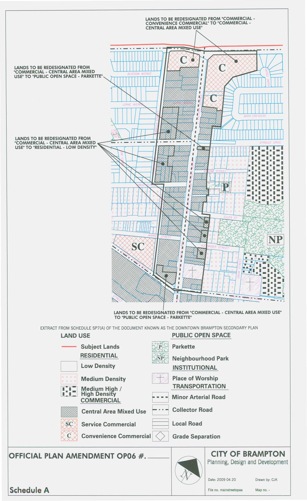
42
Mark-up of the effect of the proposed Bronte Village Growth Area OPA No.18 on the text of section 24, Bronte Village, of the Livable Oakville Plan
 Mark-up of the effect of the proposed Bronte Village Growth Area OPA No.18 on the text of section 24, Bronte Village, of the Livable Oakville Plan Notes: This document is provided for information purposes
To Adopt Amendment Number OP2006- to the Official Plan of the City of Brampton Planning Area
 To Adopt Amendment Number OP2006- to the Official Plan of the City of Brampton Planning Area The Council of The Corporation of the City of Brampton, in accordance with the provisions of the Planning Act,
PORT WHITBY COMMUNITY
 PORT WHITBY COMMUNITY SECONDARY PLAN UPDATE COMMUNITY IMPROVEMENT PLAN URBAN DESIGN GUIDELINES September 2015 DRAFT PROPOSED AMENDMENT NUMBER # to the Whitby Official Plan PURPOSE: The intent of this Amendment
DRAFT Northeast Quadrant of Kipling Avenue and Highway 7 DRAFT AUGUST 29, Goals Land Use. The goals of this Plan are to:
 AUGUST 29, 2017 12.15 Northeast Quadrant of Kipling Avenue and Highway 7 12.15.1 Goals 12.15.2 Land Use The goals of this Plan are to: 12.15.2.1 General Provisions: a) Ensure the development of a compact
Clairtrell Area Context Plan
 Clairtrell Area Context Plan March 2005 Urban Development Services City Planning Contents 1. Introduction... 4 2. Development Structure... 6 2.1 Streets... 7 2.1.1 Sheppard Avenue and Bayview Avenue...
SCHEDULE 'A' TO BY-LAW as Amended by AMENDMENT NO. 90 TO THE WHITBY OFFICIAL PLAN
 SCHEDULE 'A' TO BY-LAW 6413-10 as Amended by 6553-11 AMENDMENT NO. 90 TO THE WHITBY OFFICIAL PLAN SECTION A: GROWTH PLAN CONFORMITY PURPOSE: LOCATION: BASIS: The purpose of this Amendment is to: conform
TABLE OF CONTENTS 1.0 INTRODUCTION... 3
 TABLE OF CONTENTS 1.0 INTRODUCTION... 3 1.1. BACKGROUND... 3 1.2. THE PROPOSAL... 5 2.0 EXISTING POLICY FRAMEWORK... 5 2.1. PROVINCIAL POLICY STATEMENT (PPS)... 5 2.2. CITY OF LONDON OFFICIAL PLAN (OP)...
CONTENTS 8.0 LAND USE 8.1 GENERAL LAND USE 8.2 RESIDENTIAL 8.3 MIXED USE 8.4 COMMERCIAL 8.5 EMPLOYMENT LANDS
 8-2 Land Use 8.0 LAND USE CONTENTS 8.1 GENERAL LAND USE 8.1.1 Uses provided for in all Land Use Designations 8.1.2 Uses prohibited in Hazardous Lands, Hazardous Sites and Special Policy Areas 8.1.3 Uses
THE CITY OF VAUGHAN BY-LAW BY-LAW NUMBER A By-law to adopt Amendment Number 1 to the Official Plan of the Vaughan Planning Area.
 THE CITY OF VAUGHAN BY-LAW BY-LAW NUMBER 015-2014 A By-law to adopt Amendment Number 1 to the Official Plan of the Vaughan Planning Area. NOW THEREFORE the Council of the Corporation of the City of Vaughan
5.1 Site Plan Guidelines
 5. Community Core Guidelines Development of the Community Core will take place by plan of subdivision and site plan approval. It will occur in a phased manner that will reflect the timing of residential
THE CITY OF VAUGHAN BY-LAW BY-LAW NUMBER
 THE CITY OF VAUGHAN BY-LAW BY-LAW NUMBER 123-2013 A By-law to designate the whole of the City of Vaughan as a Site Plan Control Area, and to adopt site development guidelines and rules of procedure for
and services The protection and conservation of environmentally significant and sensitive natural heritage features and functions.
 6. Land Use 6.0 Preamble A healthy and livable city is one in which people can enjoy a vibrant economy and a sustainable healthy environment in safe, caring and diverse neighbourhoods. In order to ensure
URBAN DESIGN BRIEF. 2136&2148 Trafalgar Road. Town of Oakville
 URBAN DESIGN BRIEF 2136&2148 Trafalgar Road Town of Oakville Prepared By: METROPOLITAN CONSULTING INC For 2500674 Ontario Inc November 2016 TABLE OF CONTENTS Page No. 1.0 Introduction/Description of Subject
THE CORPORATION OF THE TOWN OF OAKVILLE BY-LAW NUMBER
 THE CORPORATION OF THE TOWN OF OAKVILLE BY-LAW NUMBER 2017-120 A by-law to adopt an amendment to the Livable Oakville Plan, Official Plan Amendment Number 20 (Downtown Oakville Growth Area) WHEREAS the
599 Kennedy Road - Official Plan Amendment and Zoning Amendment Application - Preliminary Report
 STAFF REPORT ACTION REQUIRED 599 Kennedy Road - Official Plan Amendment and Zoning Amendment Application - Preliminary Report Date: March 7, 2017 To: From: Wards: Reference Number: Scarborough Community
EXISTING COMPREHENSIVE PLAN
 EXISTING COMPREHENSIVE PLAN Town Center Land Use Element: V. LAND USE POLICIES Town Center Mercer Island's business district vision as described in "Your Mercer Island Citizen-Designed Downtown" was an
Urban Design Brief December 23, 2015 Southside Construction Group Official Plan & Zoning By-Law Amendment
 Urban Design Brief Proposed Official Plan & Zoning By-Law Amendment 3244, 3263 and 3274 Wonderland Road South Southside Group December 23, 2015 TABLE OF CONTENTS Page No. INTRODUCTION... 1 SECTION 1 LAND
11.4 Highway 400 North Employment Lands Secondary Plan APPROVED BY THE ONTARIO MUNICIPAL BOARD ON NOVEMBER 21, 2011
 11.4 Highway 400 North Employment Lands Secondary Plan APPROVED BY THE ONTARIO MUNICIPAL BOARD ON NOVEMBER 21, 2011 11.4.1 General 11.4.1.1. as approved by the Ontario Municipal Board on November 21, 2011,
DAVENPORT VILLAGE SECONDARY PLAN
 27 DAVENPORT VILLAGE SECONDARY PLAN 27. DAVENPORT VILLAGE SECONDARY PLAN 1. VISION FOR THE DAVENPORT VILLAGE SECONDARY PLAN Davenport Village, municipally known as 830, 940, 980 and 1100 Lansdowne Avenue,
URBAN DESIGN BRIEF URBAN DESIGN BRIEF 721 FRANKLIN BLVD, CAMBRIDGE August 2018
 URBAN DESIGN BRIEF URBAN DESIGN BRIEF 721 FRANKLIN BLVD, CAMBRIDGE August 2018 DESIGN BRIEF CONTENTS PART A 1.0 INTRODUCTION 2.0 DESCRIPTION & ANALYSIS OF SITE CONTEXT 3.0 DESIGN CONSTRAINTS AND OPPORTUNITIES
AMENDMENT NO. 42 TO THE OFFICIAL PLAN OF THE TOWN OF GRIMSBY
 AMENDMENT NO. 42 TO THE OFFICIAL PLAN OF THE TOWN OF GRIMSBY INITIATED BY TOWN OF GRIMSBY TABLE OF CONTENTS PART I: THE CERTIFICATION Certification Page Adopting By-law of the Town of Grimsby PART II:
Policies and Code Intent Sections Related to Town Center
 Policies and Code Intent Sections Related to Town Center The Town Center Vision is scattered throughout the Comprehensive Plan, development code and the 1994 Town Center Plan. What follows are sections
URBAN DESIGN BRIEF 181 Burloak Drive, Oakville
 URBAN DESIGN BRIEF 181 Burloak Drive, Oakville February 2017 Our File: 1730B 230-7050 WESTON ROAD / WOODBRIDGE / ONTARIO / L4L 8G7 / T: 905 761 5588/ F: 905 761 5589/WWW.MHBCPLAN.COM TABLE OF CONTENTS
Urban Design Brief 1576 Richmond Street City of London
 Urban Design Brief City of London Treadstone Developments October 31, 2014 Urban Design Brief October 31, 2014 TABLE OF CONTENTS Page No. INTRODUCTION... 1 SECTION 1 LAND USE PLANNING CONCEPT... 1 1.1
11.4 Highway 400 North Employment Lands Secondary Plan
 11.4 Highway 400 North Employment Lands Secondary Plan APPROVED BY THE ONTARIO MUNICIPAL BOARD ON NOVEMBER 21, 2011 11.4.1 General 11.4.1.1. The following policies and Schedules A - I form Official Plan
YONGE STEELES CORRIDOR SECONDARY PLAN. Young + Wright / IBI Group Architects Dillon Consulting Ltd. GHK International (Canada) Ltd.
 Ltd.") PART A: PREAMBLE 1.0 PURPOSE The purpose of this Secondary Plan is to provide a development framework for intensification of the Yonge/ Steeles corridor including the north side of Steeles Avenue West
PART A: PREAMBLE 1.0 PURPOSE The purpose of this Secondary Plan is to provide a development framework for intensification of the Yonge/ Steeles corridor including the north side of Steeles Avenue West
URBAN DESIGN BRIEF REPORT
 URBAN DESIGN BRIEF REPORT PREPARED FOR 2568401 ONTARIO INC NEW GASBAR, CONVENIENCE STORE & CARWASH DEVELOPMENT @ 1509 FANSHAWE PARK ROAD WEST LONDON, ONTARIO GAMA ENGINEERING INC. PROJECT NUMBER 1669 PREPARED
FORMER CANADIAN FORCES BASE (CFB) ROCKCLIFFE SECONDARY PLAN. Official Plan Amendment XX to the Official Plan for the City of Ottawa
 ROCKCLIFFE SECONDARY PLAN. Official Plan Amendment XX to the Official Plan for the City of Ottawa") FORMER CANADIAN FORCES BASE (CFB) ROCKCLIFFE SECONDARY PLAN Official Plan Amendment XX to the Official Plan for the City of Ottawa 1 INDEX THE STATEMENT OF COMPONENTS PART A THE PREAMBLE PAGE Purpose...
FORMER CANADIAN FORCES BASE (CFB) ROCKCLIFFE SECONDARY PLAN Official Plan Amendment XX to the Official Plan for the City of Ottawa 1 INDEX THE STATEMENT OF COMPONENTS PART A THE PREAMBLE PAGE Purpose...
Urban Design Manual PLANNING AROUND RAPID TRANSIT STATIONS (PARTS) Introduction. Station Study Areas
 Introduction. Station Study Areas") 111111 PLANNING AROUND RAPID TRANSIT STATIONS (PARTS) Introduction The ION rapid transit system will link Waterloo, Kitchener and Cambridge through a central transit corridor (CTC). There are a number
111111 PLANNING AROUND RAPID TRANSIT STATIONS (PARTS) Introduction The ION rapid transit system will link Waterloo, Kitchener and Cambridge through a central transit corridor (CTC). There are a number
BENSON / HUNT TERTIARY PLAN
 BENSON / HUNT TERTIARY PLAN TABLE OF CONTENTS 1.0 INTRODUCTION 1.1 Purpose 2 1.2 How to Read This Plan 3 1.3 Tertiary Plan Context 3 1.4 Vision and Principles 5 1.5 Public Consultation 5 2.0 PLANNING CONTEXT
Contact: Alex Taranu ( ) or Karl Walsh ( )
 or Karl Walsh ( )") Date: 09 September 2005 File: Subject: P03.DUDS Downtown Urban Design Vision Study Report Contact: Alex Taranu (905 874 3454) or Karl Walsh (905 874 2331) OVERVIEW Staff has produced an Urban Design Vision
Date: 09 September 2005 File: Subject: P03.DUDS Downtown Urban Design Vision Study Report Contact: Alex Taranu (905 874 3454) or Karl Walsh (905 874 2331) OVERVIEW Staff has produced an Urban Design Vision
[PLANNING RATIONALE] For Site Plan Control and Lifting of Holding Zone By-Law 101 Champagne Avenue. May 23, 2014
![[PLANNING RATIONALE] For Site Plan Control and Lifting of Holding Zone By-Law 101 Champagne Avenue. May 23, 2014](/thumbs/75/71599615.jpg "[PLANNING RATIONALE] For Site Plan Control and Lifting of Holding Zone By-Law 101 Champagne Avenue. May 23, 2014") [PLANNING RATIONALE] For Site Plan Control and Lifting of Holding Zone By-Law 101 Champagne Avenue May 23, 2014 Contents 1.0 Introduction... 2 2.0 Site Context... 2 2.1 Adjacent Uses... 2 Figure 1: Site
[PLANNING RATIONALE] For Site Plan Control and Lifting of Holding Zone By-Law 101 Champagne Avenue May 23, 2014 Contents 1.0 Introduction... 2 2.0 Site Context... 2 2.1 Adjacent Uses... 2 Figure 1: Site
Urban Design Brief Fanshawe Park Road. Competition Toyota
 Urban Design Brief 1300 Fanshawe Park Road Competition Toyota May 2, 2014 TABLE OF CONTENTS Page No. INTRODUCTION... 1 SECTION 1 LAND USE PLANNING CONTEXT... 1 1.1 The Subject Lands... 1 1.2 The Proposal...
Highland Village Green Design Guidelines
 Highland Village Green Design Guidelines Publishing Information Title Highland Village Green Design Guidelins Author The City of Calgary Status DRAFT - Proposed document subject to changes Additional Copies
Urban Design Guidelines Townhouse and Apartment Built Form
 Urban Design Guidelines Townhouse and Apartment Built Form Town of Wasaga Beach Table of Contents 1. Introduction 1.1. Purpose 1.2. Urban Design Principles 1.3. Application of Guidelines 2. Site Design,
Official Plan Review: Draft Built Form Policies
 PG.30.1 REPORT FOR ACTION Official Plan Review: Draft Built Form Policies Date: May 15, 2018 To: Planning and Growth Management Committee From: Chief Planner and Executive Director, City Planning Division
Bylaw A Bylaw to amend Bylaw 12800, as amended, The Edmonton Zoning Bylaw Amendment No. 2239
 Bylaw 17672 A Bylaw to amend Bylaw 12800, as amended, The Edmonton Zoning Bylaw Amendment No. 2239 WHEREAS City Council at its meeting of February 22, 2001, gave third reading to Bylaw 12800, as amended;
13 THORNHILL YONGE STREET STUDY IMPLEMENTATION CITY OF VAUGHAN OPA 669 AND TOWN OF MARKHAM OPA 154
 13 THORNHILL YONGE STREET STUDY IMPLEMENTATION CITY OF VAUGHAN OPA 669 AND TOWN OF MARKHAM OPA 154 The Planning and Economic Development Committee recommends the adoption of the recommendations contained
City of Vaughan Urban Design Guidelines for Infill Development in Established Low-Rise Residential Neighbourhoods
 City of Vaughan Urban Design Guidelines for Infill Development in Established Low-Rise Residential Neighbourhoods DRAFT - September 2016 Contents 1. Introduction 1 2. Policy Context 3 3. Characteristics
Housing and Coach House Guidelines - Ladner
 Housing and Coach House Guidelines - Ladner Policy D.8: Encourage Compatible Housing Design Encourage housing design that is sensitive to existing single family housing neighbourhoods by requiring a design
ELMVALE ACRES SHOPPING CENTRE MASTER PLAN
 ELMVALE ACRES SHOPPING CENTRE MASTER PLAN Contents 1.0 INTRODUCTION... 2 2.0 LOCATION... 2 3.0 EXISTING CONTEXT... 2 4.0 VISION & GUIDING PRINCIPLES... 2 5.0 LAND USE AND BUILT FORM... 4 5.1 St. Laurent
178 Carruthers Properties Inc.
 178 Carruthers Properties Inc. Planning Rationale for 178 Carruthers Avenue Site Plan Control Application June 2014 Table of Contents 1.0 Introduction 2.0 Overview of Subject Property 3.0 Current Zoning
QUEEN-RIVER SECONDARY PLAN
 34 QUEEN-RIVER SECONDARY PLAN 34. QUEEN RIVER SECONDARY PLAN 1. INTRODUCTION The Queen-River area is approximately 6.4 hectares and is located at the eastern edge of the Downtown as shown on Map 34-1.
6. REGIONAL AND COMMUNITY FACILITIES DESIGNATIONS 6.1. OBJECTIVES FOR REGIONAL AND COMMUNITY FACILITIES LAND USE DESIGNATIONS
 6. REGIONAL AND COMMUNITY FACILITIES DESIGNATIONS INTRODUCTION The Regional and land use designations provide the primary locations for uses which satisfy the health, education and other service needs
Dufferin Street and Centre Street Area Specific Policies
 12.XX 12.XX.1 12.XX.1.1. 12.XX.2. 12.XX.2.1. 12.XX.2.2 Dufferin Street and Centre Street Area Specific Policies Goals The goal of this Plan is to provide the necessary land use and development policies
East Bayshore Road Neighbourhood
 East Bayshore Road Neighbourhood Northridge Property Management Urban Design Brief 3195 East Bayshore Road City of Owen Sound January 2016 East Bayshore Road Neighbourhood Northridge Property Management
OFFICE CONSOLIDATION SECONDARY PLAN AREA 22 THE BRAMALEA SOUTH INDUSTRIAL SECONDARY PLAN
 OFFICE CONSOLIDATION SECONDARY PLAN AREA 22 THE BRAMALEA SOUTH INDUSTRIAL SECONDARY PLAN November 2010 EXPLANATORY NOTES (Secondary Plan Area 22) General (pertaining to all secondary plan office consolidations)
WINDSOR GLEN DESIGN GUIDELINES
 WINDSOR GLEN DESIGN GUIDELINES Adopted by Council, 2006 WINDSOR GLEN REDEVELOPMENT DESIGN GUIDELINES August 2006 1.0 Master Plan Organization For this area of the Coquitlam Town Centre, a mix of high,
Urban Design Brief Woodland Cemetery Funeral Home 493 Springbank Drive
 Urban Design Brief Woodland Cemetery Funeral Home The Incorporated Synod of the Diocese of Huron April 15, 2016 Urban Design Brief April 15, 2016 TABLE OF CONTENTS Page No. INTRODUCTION... 1 SECTION 1
*** DRAFT 2 FOR PUBLIC REVIEW ***
 6.7 The area is generally bounded by the Red Hill Valley Parkway to the west, Lake Avenue to the east, the Queen Elizabeth Way (QEW) to the north, and by the properties just south of Queenston Road to
URBAN DESIGN BRIEF Gordon Street City of Guelph. Prepared on behalf of Ontario Inc. March 25, Project No. 1507
 URBAN DESIGN BRIEF 1131 Gordon Street City of Guelph Prepared on behalf of 1876698 Ontario Inc. March 25, 2016 Project No. 1507 423 Woolwich Street, Suite 201, Guelph, Ontario, N1H 3X3 Phone (519) 836-7526
CONTENTS 6.1 URBAN DESIGN
 6-2 Urban Design and Sustainable Development 6.0 URBAN DESIGN AND SUSTAINABLE DEVELOPMENT CONTENTS 6.1 URBAN DESIGN 6.1.1 General Policies 6.1.2 The Public Realm 6.1.3 Streets and Blocks 6.1.4 Streetscapes
3. Urban Design in the Central Area
 3. Urban Design in the Central Area The Central Area Planning and Design Group assumes the responsibility to promote high quality urban and architectural design in the Central Area, plan and ensure the
OFFICE CONSOLIDATION CHAPTER 47 HIGHWAY 427 INDUSTRIAL SECONDARY PLAN
 OFFICE CONSOLIDATION CHAPTER 47 HIGHWAY 427 INDUSTRIAL SECONDARY PLAN NOTE: This Secondary Plan is partially in effect. Highlighted sections are under appeal. August 2017 1 EXPLANATORY NOTE Office Consolidation
Wide asphalt driveway abutting school property. garage built with incompatible materials, too close to park. incompatible fencing materials
 Wide asphalt driveway abutting school property incompatible fencing materials garage built with incompatible materials, too close to park Lack of plantings as a buffer between private property and open
1.0 Purpose of a Secondary Plan for the Masonville Transit Village
 Report to Planning and Environment Committee To: Chair and Members Planning & Environment Committee From: John M. Fleming Managing Director, Planning and City Planner Subject: Masonville Transit Village
Downtown Streetscape Manual & Built Form Standards
 City of Guelph Downtown Streetscape Manual & Built Form Standards July 2014 Prepared by Brook McIlroy Inc. in association with Unterman McPhail Associates and McCormick Rankin Inc. City of Guelph Downtown
Welcome. Walk Around. Talk to Us. Write Down Your Comments
 Welcome This is an information meeting introducing the applications for proposed redevelopment of the Yorkdale Shopping Centre site at 3401 Dufferin Street and 1 Yorkdale Road over the next 20+ years,
Urban Design Brief. 583, 585 and 589 OXFORD STREET EAST. Salt Clinic Canada Inc.
 Urban Design Brief 583, 585 and 589 OXFORD STREET EAST Salt Clinic Canada Inc. February 3, 2013 TABLE OF CONTENTS Page No. INTRODUCTION... 1 SECTION 1 LAND USE PLANNING CONCEPT... 1 1.1 The Subject Property...
KANATA CENTRUM 255 KANATA AVENUE OFFICIAL PLAN AMENDMENT ZONING BY-LAW AMENDMENT
 KANATA CENTRUM 255 KANATA AVENUE OFFICIAL PLAN AMENDMENT ZONING BY-LAW AMENDMENT JUNE 2015 PREPARED BY: FOTENN Consultants Inc. 223 Mcleod Street Ottawa, ON K2P OZ8 (613) 730-5709 PREPARED FOR: Kanata
4.11 Town Centre Secondary Plan (Former City of Cumberland)
") 4.11 Town Centre Secondary Plan (Former City of Cumberland) 4.11.1 Town Centre Objectives 4.11.1.1 Introduction The reason for the preparation of this Secondary Plan for the Town Centre is as follows:
4.11 Town Centre Secondary Plan (Former City of Cumberland) 4.11.1 Town Centre Objectives 4.11.1.1 Introduction The reason for the preparation of this Secondary Plan for the Town Centre is as follows:
Urban Design Brief to 1557 Gordon Street & 34 Lowes Road West
 Urban Design Brief 1533 to 1557 Gordon Street & 34 Lowes Road West Reid s Heritage Homes Ltd. & 883928 Ontario Ltd. and RHH Property Management Ltd. City of Guelph Zoning By-law Amendment November 2017
PLANNING JUSTIFICATION REPORT
 PLANNING JUSTIFICATION REPORT 55 DELHI STREET CITY OF GUELPH PREPARED FOR: VESTERRA PROPERTY MANAGEMENT PREPARED BY: LABRECHE PATTERSON & ASSOCIATES INC. SCOTT PATTERSON, BA, CPT, MCIP, RPP PRINCIPAL,
Duplex Design Guidelines
 Duplex Design Guidelines Adopted by Council May 29, 2006 Prepared By: Table of Contents 1.0 Application and Intent 1 2.0 Areas of Application 2 3.0 Design Principles 3 4.0 Design Guidelines 4 4.1 Site
A. Background Summary of Existing Challenges and Potential Possibilities. 1. Summary of Existing Assets and Potential Opportunities
 A. Background 1 A Main Street Master Plan Study was performed and completed in October of 2007. The study was initiated to review current land uses and development patterns along Main Street, from Parrish
Complete Neighbourhood Guidelines Review Tool
 Complete Neighbourhood Guidelines Review Tool Prepared By: City of Regina Planning Department October 2014 Page 1 of 14 Community Development Review Checklist for Secondary Plans and Concept Plans The
1296 Kennedy Road - Zoning Amendment Application - Preliminary Report
 STAFF REPORT ACTION REQUIRED 1296 Kennedy Road - Zoning Amendment Application - Preliminary Report Date: January 15, 2016 To: From: Wards: Reference Number: Scarborough Community Council Acting Director,
4.0 Design Guidelines For The Village Centre. South fields Community Architectural Design Guidelines Town of Caledon
 4.0 Design Guidelines For The Village Centre 4.0 Design Guidelines for the Village Centre The Village Centre is the focal point of the entire South Fields Community and is designed as a traditional commercial
Planning & Development. Background. Subject Lands
 Planning & Development APPLICATION BRIEFING Prepared For: Planning Advisory Committee Submitted by: Jason Fox, Director of Planning & Development Date: Subject: Development Agreement Application by Brentwood
PUBLIC OPEN HOUSE HURONTARIO-MAIN CORRIDOR SECONDARY PLAN
 PUBLIC OPEN HOUSE HURONTARIO-MAIN CORRIDOR SECONDARY PLAN Tuesday, February 28, 2012 6pm 9pm 1 st Floor Atrium, City Hall 2 Wellington Street West, Brampton 1 POLICY FRAMEWORK The 2006 Provincial Growth
BRAMPTON FLOWERTOWN SECONDARY PLAN Area 6
 BRAMPTON FLOWERTOWN SECONDARY PLAN Area 6 October 2018 EXPLANATORY NOTES Brampton Flowertown Secondary Plan Area 6 General i. Secondary plans form part of the Official Plan and are to be read in conjunction
Draft Urban Hamilton Official Plan. Amendment No. XX
 1 of 75 The following text, together with: Draft Appendix A Appendix B Volume 1, Schedule E-1 Urban Land Use Designations Appendix C Volume 1, Appendix A Parks Classification Map Appendix D Volume 1, Appendix
The West Vaughan Employment Area Secondary Plan Policies
 Part 2: The West Vaughan Employment Area Secondary Plan Policies 2.1 General Policies It is the policy of Council: 2.1.1. That the West Vaughan Employment Area (the WVEA), identified on Schedule 1, will
Tel: (705) Fax: (705)
 Fax: (705)") 521 and 525 Essa Road City of Barrie Tel: (705) 812-3281 Fax: (705) 812-3438 Email: INFO@IPSCONSULTINGINC.com 1 5 0 D U N L O P S T R E E T E A S T, S U I T E 2 0 1, B A R R I E O N T A R I O L 4 M 1 B
521 and 525 Essa Road City of Barrie Tel: (705) 812-3281 Fax: (705) 812-3438 Email: INFO@IPSCONSULTINGINC.com 1 5 0 D U N L O P S T R E E T E A S T, S U I T E 2 0 1, B A R R I E O N T A R I O L 4 M 1 B
Planning Districts INTRODUCTION
 INTRODUCTION To facilitate detailed examination of development prospects for all areas of the community, Delano has been divided into 14 planning districts. The location of these planning districts is
6 PORT SYDNEY SETTLEMENT AREA
 Section 6 Port Sydney Page 61 6 PORT SYDNEY SETTLEMENT AREA 6.1 Basis and Principles Village of Port Sydney Waterfront Community Existing Services 6.1.1 Port Sydney is an historic settlement that has developed
The transportation system in a community is an
 7 TRANSPORTATION The transportation system in a community is an important factor contributing to the quality of life of the residents. Without a sound transportation system to bring both goods and patrons
Proposed for Vic West Neighbourhood Plan. Design Guidelines for Intensive Residential Development - Townhouse and Attached Dwelling
 Proposed for Vic West Neighbourhood Plan Design Guidelines for Intensive Residential Development - Townhouse and Attached Dwelling Design Guidelines for Intensive Residential Development - Townhouse and
OFFICE CONSOLIDATION SECONDARY PLAN AREA 48. CHAPTER 48(b) COUNTRYSIDE VILLAGES SECONDARY PLAN
 COUNTRYSIDE VILLAGES SECONDARY PLAN") OFFICE CONSOLIDATION SECONDARY PLAN AREA 48 CHAPTER 48(b) COUNTRYSIDE VILLAGES SECONDARY PLAN October 2016 TABLE OF CONTENTS (Part II, Chapter 48(b)) Purpose. 1.0 Location 2.0 Effect of this Chapter and
OFFICE CONSOLIDATION SECONDARY PLAN AREA 48 CHAPTER 48(b) COUNTRYSIDE VILLAGES SECONDARY PLAN October 2016 TABLE OF CONTENTS (Part II, Chapter 48(b)) Purpose. 1.0 Location 2.0 Effect of this Chapter and
SUBCHAPTER 4-B GUIDELINES FOR THE B-3 COMMERCIAL CHARACTER AREA
 1 SUBCHAPTER 4-B GUIDELINES FOR THE B-3 COMMERCIAL CHARACTER AREA Downtown Bozeman should be the location of buildings of greatest height and intensity in the community. The following guidelines apply
(DC1) Direct Development Control Provision DC1 Area 4
 Direct Development Control Provision DC1 Area 4") . General Purpose (DC) Direct Development Control Provision DC Area 4 The purpose of this Provision is to provide for an area of commercial office employment and residential development in support of the
. General Purpose (DC) Direct Development Control Provision DC Area 4 The purpose of this Provision is to provide for an area of commercial office employment and residential development in support of the
Urban Design Brief. Garden Drive Townhouse Development Matas Development Group. Oakville, Ontario
 Garden Drive Townhouse Development Matas Development Group Oakville, Ontario February 8, 2013 Urban Design and Architecture 2 Introduction This Urban Design Brief has been prepared in support of a rezoning
Regency Developments. Urban Design Brief. Holyrood DC2 Rezoning
 Regency Developments Urban Design Brief Holyrood DC2 Rezoning Stantec Consulting Ltd. 7-31-2017 1. Overview Regency Developments intends to rezone the lands located at 8510 and 8511 93 Avenue, within the
Attachment 1 TOWN OF NEW TECUMSETH. Manual for the Preparation of an Urban Design Report
 Attachment 1 TOWN OF NEW TECUMSETH Manual for the Preparation of an Urban Design Report July 2010 TABLE OF CONTENTS Background, Policy Framework and the Preparation of Urban Design Reports 1. Introduction
30 and 44 Zorra Street - Zoning By-law Amendment Application - Preliminary Report
 STAFF REPORT ACTION REQUIRED 30 and 44 Zorra Street - Zoning By-law Amendment Application - Preliminary Report Date: March 14, 2016 To: From: Wards: Reference Number: Etobicoke York Community Council Director,
PLANNING RATIONALE FOR THE PROPOSED RIVERSIDE SOUTH ELEMENTARY SCHOOL 715 BRIAN GOOD AVENUE, OTTAWA, ON
 PLANNING RATIONALE FOR THE PROPOSED RIVERSIDE SOUTH ELEMENTARY SCHOOL 715 BRIAN GOOD AVENUE, OTTAWA, ON Conseil des écoles publiques de l'est de l'ontario (CEPEO) French Public School Board TABLE OF CONTENTS
COMMUNITY DESIGN. GOAL: Create livable and attractive communities. Intent
 COMMUNITY DESIGN Intent An attractive, well-designed County will attract quality development, instill civic pride, improve the visual character of the community, and create a strong, positive image for
MIXED-USE VILLAGE OVERLAY FLOATING DISTRICT
 MIXED-USE VILLAGE OVERLAY FLOATING DISTRICT Zoning regulations developed by committee to the Planning Board for the Town of DeWitt, NY Issue date: 13 July 2017 revised 3/12/2018, revised 4/26/2018, 5/9/2018
Official Community Plan Bylaw No. 4360, 2004, Amendment Bylaw No. 4897, 2016 (Sewell s Landing)
") District of West Vancouver Official Community Plan Bylaw No. 4360, 2004, Amendment Bylaw No. 4897, 2016 (Sewell s Landing) Effective Date: 1089612v1 District of West Vancouver Official Community Plan Bylaw
District of West Vancouver Official Community Plan Bylaw No. 4360, 2004, Amendment Bylaw No. 4897, 2016 (Sewell s Landing) Effective Date: 1089612v1 District of West Vancouver Official Community Plan Bylaw
Wellington Street West - Zoning Amendment Application - Preliminary Report
 STAFF REPORT ACTION REQUIRED 485-489 Wellington Street West - Zoning Amendment Application - Preliminary Report Date: September 26, 2016 To: From: Wards: Reference Number: Toronto and East York Community
Urban Design Brief. Watson Parkway North & Watson Road North Guelph, Ontario. Prepared by Coletara Development
 Urban Design Brief Watson Parkway North & Watson Road North Guelph, Ontario Prepared by Coletara Development December, 2013 Urban Design Brief, Coletara Development 1 Introduction This Urban Design Brief
4.1.3 LAND USE CATEGORIES
 4.1.3 LAND USE CATEGORIES a. City Center District The City Center District incorporates the existing character and mix of uses in downtown Belmont to encourage redevelopment and new development in keeping
Uptown Rideau Street Secondary Plan [Amendment #166, January 12, 2016]
![Uptown Rideau Street Secondary Plan [Amendment #166, January 12, 2016]](/thumbs/76/73760497.jpg "Uptown Rideau Street Secondary Plan [Amendment #166, January 12, 2016]") [Amendment #166, January 12, 2016] The policies of this Secondary Plan are in effect, save and except for the property at 560 Rideau Street, for which there remains a site specific appeal to this Secondary
[Amendment #166, January 12, 2016] The policies of this Secondary Plan are in effect, save and except for the property at 560 Rideau Street, for which there remains a site specific appeal to this Secondary
11.3 Steeles West Secondary Plan
 11.3 Steeles West Secondary Plan ADOPTED BY VAUGHAN CITY COUNCIL NOT YET APPROVED BY THE ONTARIO MUNICIPAL BOARD 11.3.1 Introduction This Secondary Plan recognizes that it will take a number of years for
Chapter PEDESTRIAN COMMERCIAL (PC) ZONING DISTRICT
 ZONING DISTRICT") Chapter 11-17 PEDESTRIAN COMMERCIAL (PC) ZONING DISTRICT Sections: 11-17-01 GENERAL PURPOSE 11-17-02 PERMITTED BUILDING TYPES 11-17-03 USES PERMITTED WITH DESIGN REVIEW 11-17-04 USES PERMITTED BY CONDITIONAL
Chapter 11-17 PEDESTRIAN COMMERCIAL (PC) ZONING DISTRICT Sections: 11-17-01 GENERAL PURPOSE 11-17-02 PERMITTED BUILDING TYPES 11-17-03 USES PERMITTED WITH DESIGN REVIEW 11-17-04 USES PERMITTED BY CONDITIONAL
John M. Fleming Managing Director, Planning and City Planner. Old East Village Dundas Street Corridor Secondary Plan Draft Terms of Reference
 Report to Planning and Environment Committee To: From: Subject: Chair and Members Planning & Environment Committee John M. Fleming Managing Director, Planning and City Planner Old East Village Dundas Street
Urban Design Brief Proposed Residential Development 5219 Upper Middle Road City of Burlington
 Urban Design Brief Proposed Residential Development 5219 Upper Middle Road City of Burlington Prepared by Weston Consulting Prepared for BLOOMFIELD DEVELOPMENT INC. Date: March 2017 Table of Contents 1.
CHAIR AND MEMBERS PLANNING & ENVIRONMENT COMMITTEE JOHN M. FLEMING MANAGING DIRECTOR, PLANNING AND CITY PLANNER
 TO: FROM: SUBJECT: CHAIR AND MEMBERS PLANNING & ENVIRONMENT COMMITTEE JOHN M. FLEMING MANAGING DIRECTOR, PLANNING AND CITY PLANNER APPLICATION BY: THE CORPORATION OF THE CITY OF LONDON OUTDOOR PATIOS IN
Bel-Air Lexus Automobile Service Station
 Bel-Air Lexus Automobile Service Station Design Brief 443-447 McArthur Avenue Ottawa April 30, 2015 14-1299-MCA Site Details Application: Site Plan Control Legal Description and Municipal Addresses: 443
SECTION UNIFIED DEVELOPMENT ORDINANCE SECTION Part 1 Ordinance. ARTICLE 1 Zoning Districts
 SECTION 1-100 UNIFIED DEVELOPMENT ORDINANCE SECTION 1-300 Part 1 Ordinance SECTION 1-100. Introduction. ARTICLE 1 Zoning Districts Crystal Lake strives to maintain a balance of various land uses for a