The Capital Design Advisory Committee St. Mary s College of Maryland & Historic St. Mary s City
|
|
|
- Brendan Miller
- 5 years ago
- Views:
Transcription
1 The Capital Design Advisory Committee St. Mary s College of Maryland & Historic St. Mary s City Welcome April 21, 2010 Capital Design Advisory Presentation: Relocating Margaret Brent Hall Traffic Calming HSMC Woodshop Chancellor s Point Project Joint Maintenance Storage Facility Anne Arundel Hall/ Maryland Heritage Interpretive Center Update


2 Relocating Margaret Brent Hall Provides 4,500 GSF for Philosophy & Religious Studies Will not increase impervious runoff Will require archaeology study under the existing parking lot New ADA Walk + Graves Campus Center Margaret Brent Will improve ADA accessibility between the parking lot and the main entrance to the Campus Center Is not in the viewshed traveling northbound on Route 5 New Parking Recycles an existing structure Loss of parking for building offset by new parking lot (AAH/MHIC)
3 Traffic Calming - Refresher Review of Past Actions The College originally proposed a pedestrian bridge overpass on Rt. 5 The College conducted a traffic study with input from a traffic consultant, State Highway Administration, and Community Design Advisory After careful consideration, the concept of traffic calming was determined to be the most appropriate and effective method of improving safety along the campus Rt. 5 corridor This information was presented at open houses and the February 17, 2009 Community Design Advisory Meeting Traffic Calming Goals (as prioritized by community survey results) Improve pedestrian safety Preserve environment Preserve archaeology Cost Improve bicycle safety Preserve viewshed Improve vehicle safety Improve accessibility Minimize vehicular congestion Enhance sense of arrival

4 Traffic Calming Conceptual Ideas Traffic Calming Project Limits Traffic Calming May Include: Narrowed traffic lanes from 11ft-12ft to 10ft- 11ft Median islands Enhanced crosswalks with colored/textured pavement and improved pavement markings Bicycle lanes in road shoulders Sidewalks with curbs for pedestrians Landscaping to alert motorists that they have entered a more urban area Street lighting at crosswalks and along sidewalks Improved intersection at Route 5 and Trinity Church Rd. Sidewalks leading to the North Field Landscaped medians to serve as gateways with signage welcoming travelers to St. Mary s City and the College Realigning Mill Field Drive with State House Road Traffic circles at intersections Improved access to the post office parking lot
5 Traffic Calming Upcoming Process Hire Traffic Engineer - Summer 2010 Hold 1 st public meeting to discuss the full palette of traffic calming options Fall 2010 Develop 3 option packages considering general feedback from 1 st public meeting - Fall 2010 Present option packages at 2 nd public meeting Winter 2011 Develop a final schematic design considering feedback from 2 nd public meeting - Winter 2011 Present schematic design at 3 rd public meeting Winter 2011 Develop design and present at 4 th public meeting Spring 2011 Complete construction documents Summer 2011 Bid project for construction Fall 2011 Construction project Spring/Summer 2012


6 HSMC Blue Barn Replacement: Woodshop CONSTRUCTION OF A TIMBER FRAME WOODSHOP MEETS A VARIETY OF NEEDS Workshop for maintenance and repair of Museum exhibits Maryland Dove Historic reconstructions Proposed timber frame woodshop is sympathetic to existing architecture Space for Instruction in Timber Framing Classes with SMCM Workshops for the public Opportunities for demonstrations of historic skills and crafts Proposed Woodshop

7 Chancellor s Point: Historic St. Mary s City Part of Historic St. Mary s City Commission 66 acre site on St. Mary s River St. Mary s College Special features of the property Nature Center building Archaeology Possibilities for water access Mostly wooded Views across the Bay Accessible on HSMC trail system Route 5


8 Chancellor s Point Project Once the site of HSMC Nature Center and the Woodland Indian Hamlet Now being rehabilitated for use as an environmental field station and to support study of: Water quality Shoreline Flora Art Literature Perma-culture/Sustainable farming Astronomy Leave No Trace (human impact)

9 Joint Maintenance Storage Facility Water Tower Barn Gated Driveway Entrance New Storage Facility 50 x 144 Graveled Area Wooded Areas Garage Existing HSMC Maintenance Building Shared Use HSMC/SMCM 7200 Sq. Ft. Pre-Engineered Metal Building Minimal Tree Removal No Archaeological Concerns No Increase of Impervious Surface 500 Set Back From Mattapany Road Mattapany Road

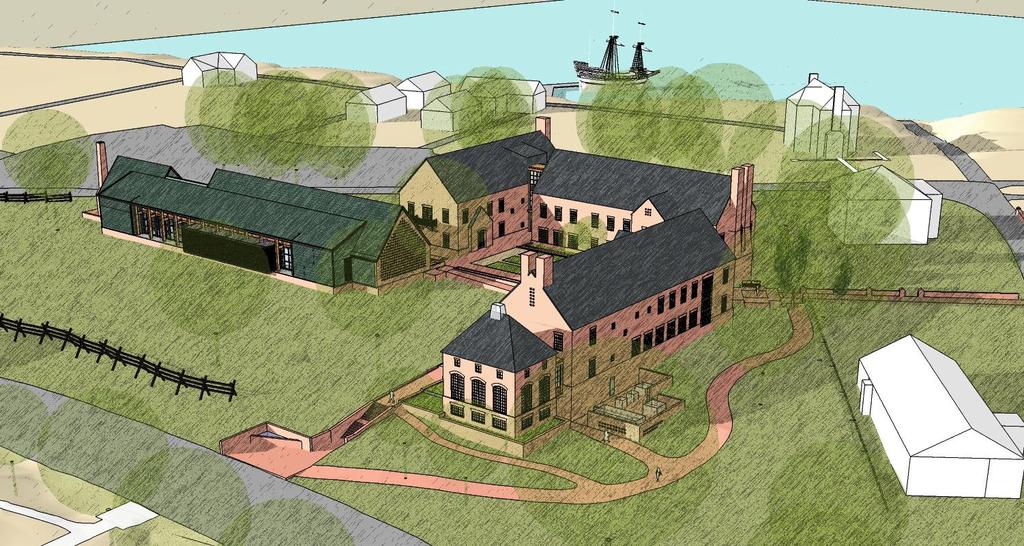
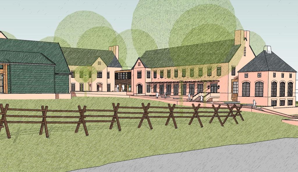
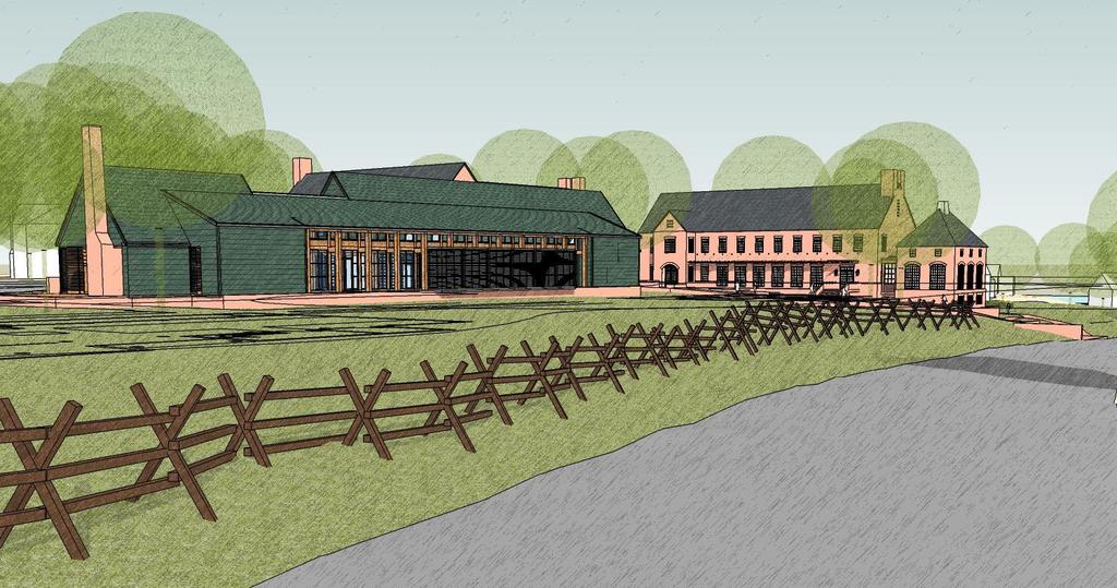
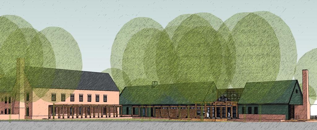
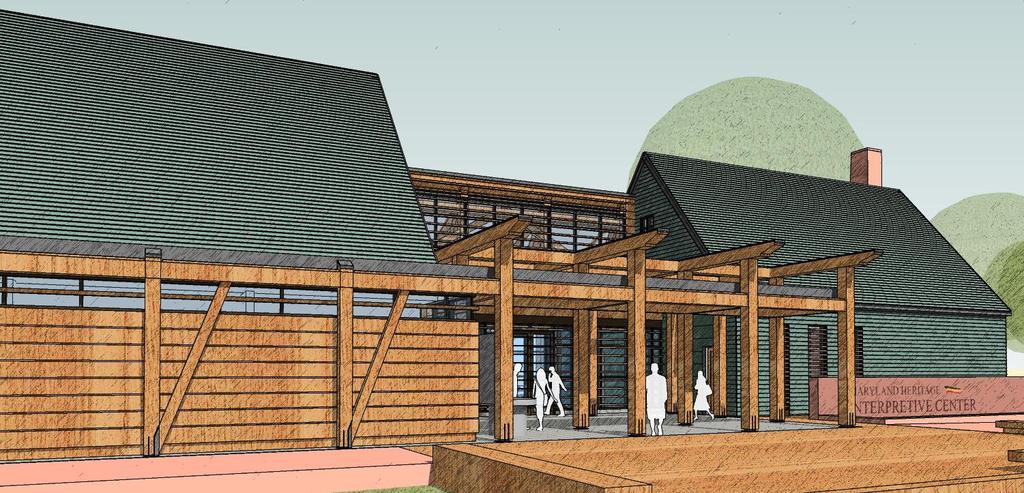
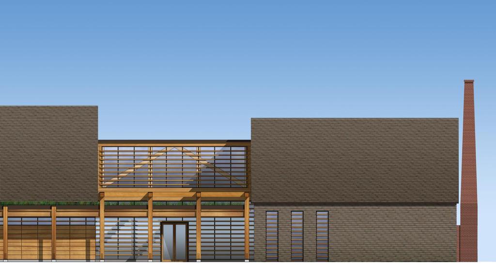
10 SITE PLAN Parish hall Rectory Anne Arundel Hall SMCM Academic Anne Arundel Hall SMCM Academic Anne Arundel Hall HSMC Archaeological Curation Maryland Heritage Interpretive Center Farthing s ordinary
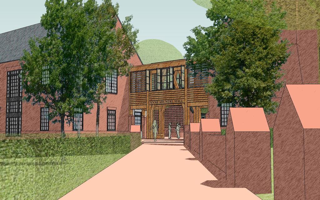
11 Program goals Anne Arundel Hall: College Academic Anthropology/Archaeology Colonial History Museum Studies Language & Cultures City archaeologists teach College courses Students work in City labs City archaeologists & College faculty mentor senior projects using collections Artifacts, Archives, and Research Library accessible for faculty research Promotes collaboration between College faculty and City archaeologists and curators Anne Arundel Hall: Archaeological Curation Research & Processing Collection Storage Library & Archives Interpretive Center serves as real life teaching lab for Museum Studies program Museum Studies senior projects develop changing exhibits for Interpretive Center Promotes collaboration between College faculty & City interpretive center staff Archaeology/Curation labs become exhibits of themselves and integrated into the visitor experience Interpretive Center Permanent Exhibits Changing Exhibits Theater

12 Project goal: Avoid areas of high archaeological significance Archaeology for construction: A practiced process In accordance with State and Federal requirements: Step 1- Survey the site, identify archaeology and its significance Step 2- Develop building plans that preserve/avoid archaeology to the extent possible Step 3- Develop an archaeological mitigation plan to be approved and permitted by the Maryland Historic Trust Step 4- Complete the excavations, then begin construction State House Legend Calvert Hall Kent Hall Area of high archaeological significance Anne Arundel Hall Interpretive Center


13 Archaeological Investigation Status Report Anne Arundel Hall Site Previous archaeological work in the site area was examined to best determine areas of high versus medium and low archaeological sensitivity. Existing parking lots: Findings show that each lot has varying amounts of preservation. Below the 1950s building:. Some areas are fully disturbed from 1950s construction, but other portions have varying levels of preservation in place. The project design is deliberately avoiding areas of high archaeological sensitivity. NEXT ACTION: Begin archaeological mitigation of specified areas of impact within the project area. Mill Field Site New parking entrance: 5 test pits were dug. Findings show that the archaeological deposit was already heavily disturbed by previous road and utility work. Mill Field: 21 additional test pits were dug further infield and demonstrated that, in this area, the archaeological deposits are intact. Cultural features and artifacts are present in this portion of the project area. The project design preserves the areas of high archaeological significance and most archaeological zones of lesser significance by constructing on graded fill rather than excavating into the existing soils. NEXT ACTION: Complete mitigation of areas directly impacted by utilities, drainage facilities and other services when project design is completed.
14
15
16
17
18
19
20
21
New York Avenue Streetscape and Trail Project Public Meeting #1 Summary
 New York Avenue Streetscape and Trail Project Public Meeting #1 Summary I. King Jordan Student Academic Center (SAC) Gallaudet University, Washington, DC February 23, 2017 Table of Contents 1.0 Introduction...
The Illinois Department of Transportation and Lake County Division of Transportation. Route 173, including the Millburn Bypass
 The Illinois Department of Transportation and Lake County Division of Transportation welcome you to this Public Hearing for U.S. Route 45 from Illinois Route 132 to Illinois Route 173, including the Millburn
West Dennis Center: Bass River to Old Main Street. West Dennis Business District: Old Main Street to Dennis Commons
 West Dennis Center: Bass River to Old Main Street West Dennis Business District: Old Main Street to Dennis Commons Dennisport Center: Dennis Commons to Division Street Main Street Project Goals Project
Alternatives Development Three conceptual alternatives were developed for the Race Road/Jessup Village Planning Study and are described below:
 Race Road/Jessup Village Planning Study (H550601) Project Newsletter Spring 2015 Project Description The Study Team, consisting of staff from Anne Arundel County (Department of Public Works and Department
APPENDIX D: Visual and Aesthetic Conditions for NCCU Station Refinement. Durham-Orange Light Rail Transit Project
 APPENDIX D: Visual and Aesthetic Conditions for NCCU Station Refinement Durham-Orange Light Rail Transit Project October 2016 1. Introduction The Combined FEIS/ROD summarizes the effects of the D-O LRT
BRADENTON RIVERWALK EXPANSION MASTER PLAN
 BRADENTON RIVERWALK EXPANSION MASTER PLAN INTRODUCTION & AGENDA Process Update Community Engagement Summary Center for Active Design (CfAD) Recommendations Context and Existing Conditions Master Plan Alternatives
CAMPUS MASTER PLAN UPDATE
 CAMPUS MASTER PLAN UPDATE Wayf inding and Signage DISCLAIMER: The following presentation represents in-progress work generated to test various elements of the ongoing campus planning effort along with
Capital Projects in and near Odenton Town Center
 Capital Projects in and near Odenton Town Center Map ID Anne Arundel County Department of Public Works This project provides for the design, right of way acquisition, and construction of approximately
Capital Projects impacting Odenton Town Center
 Capital Projects impacting Odenton Town Center 1 2 E549700 W801600/ W801602 Anne Arundel County Department of Public Works Manor View Elementary School Transmission Main - MD 32 @ Meade Phase 2 $34,399,000
Mississippi Drive Corridor Revitalization. A DestinationTransportation Project...
 Mississippi Drive Corridor Revitalization A DestinationTransportation Project... Mississippi Drive Corridor Revitalization Welcome! Tonight s Agenda: Further define the Scope of the Project Discuss the
Focus Group First Meeting Belfountain Community Centre Tuesday June 29, :00 p.m. to 9:00 p.m.
 Focus Group First Meeting Belfountain Community Centre 7:00 p.m. to 9:00 p.m. Mississauga Road/Old Main Street and Bush Street, from Olde Base Line Road to Winston Churchill Boulevard Environmental Assessment
The Auburn Plan Designing the Future of Auburn February 28, 2005
 The Auburn Plan Designing the Future of Auburn February 28, 2005 Block-by-Block Bicycle Tour Aerial survey Focus Group Meetings September 7 and 8 Design Workshops October 11, 14, and 21 Revitalization
38 Queen s University Campus Master Plan Part 1
 38 Queen s University Campus Master Plan Part 1 46 The Campus at the City Scale Chapter 4 The Campus at the City Scale 39 Queen s is an urban University centrally located in Kingston. Decisions made by
UNCW CAMPUS MASTER PLAN
 UNCW CAMPUS MASTER PLAN JULY 27, 2017 MASTER PLAN FRAMEWORK RECOMMENDATIONS BOARD OF TRUSTEES PRESENTATION UNCW Campus Master Plan Update Board of Trustees Presentation July 27, 2017 The attached Campus
Open House RIVER DES PERES GREENWAY: LANSDOWNE SHREWSBURY METROLINK TO FRANCIS R. SLAY PARK
 Open House 10.12.16 RIVER DES PERES GREENWAY: LANSDOWNE SHREWSBURY METROLINK TO FRANCIS R. SLAY PARK MEETING AGENDA Great Rivers Greenway and Project Partners River des Peres Greenway Overview Project
The Vision. Photo provided by The Minervini Group. 46 Vision, Objectives & Strategies
 Vision, Objectives & Strategies The is the public framework and guide for future development of the Grand Traverse Commons. The establishes public polices for infrastructure, the preservation of natural
Town of Peru Comprehensive Plan Executive Summary
 Town of Peru Comprehensive Plan Executive Communities that plan grow by choice, not by chance. A plan makes growth thoughtful, understandable, and predictable. A plan shows that a community is managing
Overview and Update of the Rutgers-New Brunswick Physical Master Plan. January 2015
 Overview and Update of the Rutgers-New Brunswick Physical Master Plan January 2015 Failure To Plan, is Planning For Failure Winston Churchill 2 Good Planning; The Key to Success 3 The university physical
FY STATEWIDE TRANSPORTATION IMPROVEMENT PROGRAM New Jersey Department of Transportation Project Descriptions ($ millions)
") ADA Central, Contract 1 DBNUM: 15417 / UPC: 154170 This contract will bring projects into compliance with current ADA design requirements that could not be completed within original design or construction
ADA Central, Contract 1 DBNUM: 15417 / UPC: 154170 This contract will bring projects into compliance with current ADA design requirements that could not be completed within original design or construction
AUSTIN MEDICAL DISTRICT MASTER PLAN"
 AUSTIN MEDICAL DISTRICT MASTER PLAN"!"#$%&'"()(&$*+,--$ ,$?+,'=2,)0$!)=@,+'=03$AB,+-(C)'$ DE,$!)=@,+'=03$C/$D,F-'$-0$%&'()$ $?-),H='0'P$.(/$0&1"23$ $ G,)=C+$,$?+,'=2,)0$ G,0C)$
WELCOME! 8 8:30 6: TH STREET IMPROVEMENTS. Open House. Presentation & Q&A
 WELCOME! 168 TH STREET IMPROVEMENTS 6:30 Open House 7 8 Presentation & Q&A 8 8:30 Open House WELCOME Todd Pfitzer City of Omaha Engineer Bob Stubbe City of Omaha Public Works Director Jon Meyer Project
SOUTH UNIVERSITY Street Design Alternatives in Progress
 1 Alternatives in Progress 2016.01.20 Meeting Agenda 2 1. Progress & Schedule 2. Utilizing the Street Design Manual 3. Site Characteristics and Input Received 4. Street Geometry What can we accomplish
TRANSPORTATION & STREET DESIGN
 TRANSPORTATION & STREET DESIGN Review of Goals Connect neighborhoods to Square Enable access to the river Improve pedestrian environment Reorient road network to local use Three Specific Areas of Intervention
FY STATEWIDE TRANSPORTATION IMPROVEMENT PROGRAM New Jersey Department of Transportation Projects
 Route 1&9, County Road 99380 99380 Improvements are planned at the Route 1&9, County Road intersection to address operational and safety issues in the vicinity of Manhattan Avenue and County Road. COUNTY:
Rt. 29 Solutions Project Delivery Advisory Panel. January 7, 2016
 Rt. 29 Solutions Project Delivery Advisory Panel January 7, 2016 Agenda item 1: Introductions Project Delivery Advisory Panel Technical Team 2 Agenda item 2: Interaction and Feedback Live Streaming Dec
Landscape Heritage Plan
 University of California, Berkeley Landscape Heritage Plan UC Berkeley Physical and Environmental Planning Sasaki Associates The Getty Foundation Planning Framework SAFER Study Seismic analysis and $1.2
Potential Green Infrastructure Strategies May 6, 2015 Workshop
 Potential Green Infrastructure Strategies May 6, 2015 Workshop Background The City of Cortland is developing the Tioughnioga Urban Headwaters Green Infrastructure Action Plan with funding from the National
FY STATEWIDE TRANSPORTATION IMPROVEMENT PROGRAM New Jersey Department of Transportation Projects
 69th Street Bridge 02311 02311 A grade separation at 69th Street would eliminate the current at-grade crossing which causes frequent automobile delays due to long freight trains moving through this area.
ESTABLISH AN EFFICIENT TOWN CENTER
 ESTABLISH AN EFFICIENT TOWN CENTER 4 Overview Lisbon residents are proud of the history of Newent and at the same time recognize its current importance as a centralized location for a variety of municipal
11.0 TRANSPORTATION ELEMENT
 11.0 TRANSPORTATION ELEMENT Transit, Circulation and Parking Sub-Element: For all campuses, FIU's goal is to increase multimodal access. In combination with other measures - such as the development of
A21. Start of works exhibition Tonbridge to Pembury. Welcome. Dualling Scheme
 Welcome We would like to welcome you to our start of works exhibition for the. On display you will see information about what is currently taking place and what will be happening during the coming months
FROST CAMPUS MASTER PLAN SIR SANDFORD FLEMING COLLEGE
 FROST CAMPUS MASTER PLAN SIR SANDFORD FLEMING COLLEGE SEPT 2015 TABLE OF CONTENTS 1.0 Introduction 01 1.1 Master Plan Purpose 1.2 About The Campus 2.0 The Campus Master Plan 05 2.1 Vision Statement 2.2
CITY OF BOYNTON BEACH SE 1 ST STREET COMPLETE STREETS IMPROVEMENTS
 CITY OF BOYNTON BEACH SE 1 ST STREET COMPLETE STREETS IMPROVEMENTS N Project Location -Town Square -Villages at Ocean SE 1st St, between E Woolbright Rd and SE 2nd Ave Project Location -Boynton One -Publix
FY STATEWIDE TRANSPORTATION IMPROVEMENT PROGRAM New Jersey Department of Transportation Projects
 ROUTE/ Project ID No. TIP No. Burlington County Computerized Signal Control, IV D9911 D9911 This ITS project will be a traffic responsive signal system, consisting of 24 intersections--9 on CR 607, 4 on
Secrest Short Cut and Monroe Expressway Small Area Plan AUGUST 29, 2018
 Secrest Short Cut and Monroe Expressway Small Area Plan AUGUST 29, 2018 Background and Process Monroe Expressway will be open by the end of 2018 Union County and Indian Trail identified a need to revisit
d Escoto, M. City of Chicago Streetscape and Urban Design Program, Chicago Department of Transportation. (2003). Streetscape Guidelines.
. Streetscape Guidelines.") WORKS CITED McCann, B., & Rynne, S. Planning Advisory Service, (n.d.). Complete streets: Best policies and implementation strategies (559). Retrieved from American Planning Association website: http://www.smartgrowthamerica.org/documents/cs/resources/cs-bestpractices-chapter5.pdf
WORKS CITED McCann, B., & Rynne, S. Planning Advisory Service, (n.d.). Complete streets: Best policies and implementation strategies (559). Retrieved from American Planning Association website: http://www.smartgrowthamerica.org/documents/cs/resources/cs-bestpractices-chapter5.pdf
SR-2 Freeway Terminus Improvement Project
 SR-2 Freeway Terminus Improvement Project Welcome! Public Hearing, Mayberry Elementary June 16, 2009, 6:30 p.m. 8:30 p.m. Agenda 6:30 PM 6:50 PM Registration and Open House 6:50 PM 7:00 PM Welcome and
Preliminary Sketch Plan for Fort Hunter Park
 Preliminary Sketch Plan for Fort Hunter Park Public Presentation November 19, 2009 Dauphin County Parks and Recreation 100 Fort Hunter Road Harrisburg, PA 17110 (717) 599-5188 www.dauphinc.org THOMAS COMITTA
Planning Districts INTRODUCTION
 INTRODUCTION To facilitate detailed examination of development prospects for all areas of the community, Delano has been divided into 14 planning districts. The location of these planning districts is
Mavis Road Class Environmental Assessment
 Mavis Road Class Environmental Assessment Public Information Centre #2 Wednesday November 9, 2016 6:00 to 8:00 p.m. Please sign in and complete a comment sheet Review the displays on your own or join in
BENJAMIN BANNEKER PARK FRAMEWORK PLAN (PLAN ADOPTION)
") BENJAMIN BANNEKER PARK FRAMEWORK PLAN (PLAN ADOPTION) COUNTY BOARD MEETING DECEMBER 16, 2017 County Board Consideration: Adopt the Benjamin Banneker Park Framework Plan and Design Guidelines Framework
BENJAMIN BANNEKER PARK FRAMEWORK PLAN (PLAN ADOPTION) COUNTY BOARD MEETING DECEMBER 16, 2017 County Board Consideration: Adopt the Benjamin Banneker Park Framework Plan and Design Guidelines Framework
LOS ANGELES MISSION COLLEGE MASTER PLAN Master Plan DESIGN & DEVELOPMENT PRINCIPLES
 LOS ANGELES MISSION COLLEGE MASTER PLAN DESIGN & DEVELOPMENT PRINCIPLES 34 Quality Learning Along the Arroyo PROGRAM SUMMARY BY PROJECT The following are program summaries for each of the projects planned
Derby-Shelton Bridge Pedestrian and Bicyclist Enhancements [1]
![Derby-Shelton Bridge Pedestrian and Bicyclist Enhancements [1]](/thumbs/96/128011958.jpg "Derby-Shelton Bridge Pedestrian and Bicyclist Enhancements [1]") nhancements [1] STATUS OF PROJECT: The project has recently moved from the Preliminary Design Phase to the Final Design Phase following the most recent Public Involvement Meeting held on January 9, 2019
nhancements [1] STATUS OF PROJECT: The project has recently moved from the Preliminary Design Phase to the Final Design Phase following the most recent Public Involvement Meeting held on January 9, 2019
John Portman Boulevard Corridor
 Corridor Multi-use Path + Streetscape Improvements February 8, 13 SOUTH SIDE BLOCK IMPROVEMENT NOTES: Consolidation of Utility/Sign Locations Remove Existing Trees Centennial Olympic Park Drive Planter
OPPORTUNITIES AND CONSTRAINTS - OXBOW PARK ENTRANCE AND PUT-IN
 OPPORTUNITIES AT OXBOW EXISTING WETLANDS Site is undeveloped and we can design a park that works well from the start. SAND BEACH Potential to eliminate invasive species. DEBRIS (CONCRETE, OLD CARS) VEGETATION
 Health Sciences City The available land area, although limited, combined with the unique partnership between the primary institutions and the supporting partnerships of the development interests within
DRAFT MAP AMENDMENT FLU 04-4
 DRAFT MAP AMENDMENT FLU 04-4 SW 24 TH AVENUE ROADWAY CORRIDOR The University of Florida participates with the Metropolitan Transportation Planning Organization (MTPO) in its responsibilities for the continuing,
Executive Summary. NY 7 / NY 2 Corridor
 Executive Summary NY 7 / NY 2 Corridor Transportation and Land Use Study December 2005 Prepared for: Town of Colonie Capital District Transportation Committee Prepared by: Introduction: Land use decisions
Municipal Class EA Study Public Information Centre No. 1 December 13, :00 pm 7:00 pm. Please sign in so we can keep you updated on this study
 Reconstruction of Regional Road 45 (Creek Road) Between Regional Road 27 (River Road) and Regional Road 63 (Canborough Road) in the Township of Wainfleet Municipal Class EA Study Public Information Centre
Project Goal. RRRC Living Towns Planning Workshp. Town of Halifax Revitalization Project. Dynamic Planning & Management Duo: July 12, 2006
 Project Goal Town of Halifax Revitalization Project RRRC Living Towns Planning Workshp July 12, 2006 Town of Halifax Halifax County *** Revitalization Project Goal*** To create Economic Opportunity and
Seneca Meadows. Block 4 Locate office, technology, and medical development adjacent to I Screen views of garage structures from I-270.
 Seneca Meadows Seneca Meadows has an industrial park in its southern end and a mixed-use employment area planned for the north end. The district benefits from extensive I-270 visibility, stream valley
Bethlehem Pike Streetscape Master Plan
 Bethlehem Pike Streetscape Master Plan Prepared for Springfield Township October 2008 By Michael Baker Jr., Inc. Carter Van Dyke Associates Table of Contents 1. Introduction 3 2. General Corridor Wide
FY 2005 TRANSPORTATION CAPITAL PROGRAM
 Camden County Civic Center Access Study, Pennsauken 03340 This project will address operational and access improvements on Routes 30, 73 and 90 related to the Crossroads redevelopment project around the
2017 General Obligation Bond
 2017 General Obligation Bond Presentation of Public and Council Projects to the Transportation & Mobility Stakeholder Committee April 13, 2017 Agenda Deferred Maintenance Project Development Process Projects
COMPLETE GREEN STREET CHECKLIST
 COMPLETE GREEN STREET CHECKLIST This document was developed to dissect the structure of an urban street and explore opportunities to make our streets more complete while also integrating green street strategies.
Section4 Design Vision & Implementation Plan
 Section4 Design Vision & Implementation Plan W Woodschurch Rd 4.1 Design Focus Areas The Framework Plan is simply the starting point for directing the design and implementation of a wide range of transportation
To qualify for federal Transportation Enhancement (TE) funds a project must meet two basic federal requirements:
 funds a project must meet two basic federal requirements:") Eligibility Requirements To qualify for federal Transportation Enhancement (TE) funds a project must meet two basic federal requirements: 1) Relate to surface transportation and 2) Be one of the 12 designated
Eligibility Requirements To qualify for federal Transportation Enhancement (TE) funds a project must meet two basic federal requirements: 1) Relate to surface transportation and 2) Be one of the 12 designated
Rt. 29 Solutions Project Delivery Advisory Panel. December 3, 2015
 Rt. 29 Solutions Project Delivery Advisory Panel December 3, 2015 Agenda item 1: Introductions Project Delivery Advisory Panel Technical Team 2 Agenda item 2: Interaction and Feedback Live Streaming Nov
VIRGINIA KEY CONSENSUS MASTER PLAN
 VIRGINIA KEY CONSENSUS MASTER PLAN JULY 2010 Existing Conditions JULY 2010 STAKEHOLDER INTERVIEW PROCESS, January 18-22, 2007 PUBLIC MEETING #1: SITE INVENTORY AND ANALYSIS, March 29, 2007 PUBLIC MEETING
Southern Gateway Project and Public Green
 Southern Gateway Project and Public Green Transportation and Trinity River Project Committee May 23, 2016 Purpose of Presentation Provide the history and an overview of the Southern Gateway Project (SGP)
I-95 Girard Avenue Interchange Near Neighbors Meeting. Project Status
 I-95 Girard Avenue Interchange Project Status Construction is underway for Phase 1 and 2. Phase 3 construction will begin early 2014. Overall Project Area and Schedule GR0: Completed GR0: Completed in
Fall 2017 Construction Update
 Fall 2017 Construction Update Ward 4 Southeast Engineering Department Riverwalk Red Multi-Use Trail Bridge Rehabilitation The Riverwalk Red Multi Use Trail Bridge was awarded to Cramer and Associates,
CITY OF NORCROSS LILLIAN WEBB PARK REDEVELOPMENT AREAS
 7/2/2016 CITY OF NORCROSS LILLIAN WEBB PARK REDEVELOPMENT AREAS 2016 Potential Development Around Lillian Webb Park The Lillian Webb Park Development Project is located north of Buford Highway; east of
4 CIRCULATION AND TRANSPORTATION
 4 CIRCULATION AND TRANSPORTATION 4.1 INTRODUCTION One of the central concepts of the Hecker Pass Specific Plan is to maintain the rural character and scenic qualities of the area. The transportation and
Johnson Street Bridge Public Realm Update
 Johnson Street Bridge Public Realm Update August 20, 2015 Background Johnson Street Bridge Replacement Project impacts a diverse range of stakeholders In addition to a new bridge, the project also includes
Preci nct P l ans Figure 56 Campus Aerial Photo, 2008 CAL STATE EAST BAY, HAYWARD CAMPUS MASTER PLAN
 9 Precinct Plans This section contains a detailed discussion of the planning and design concepts for specific areas or precincts of the Cal State East Bay Hayward campus. The Precinct Plans pertain to
I-494 Rehabilitation Project SP (I-394 to Fish Lake Interchange) June 2014 Section 4(f) De Minimis Determination
 June 2014 Section 4(f) De Minimis Determination") I-494 Rehabilitation Project SP 2785-330 (I-394 to Fish Lake Interchange) June 2014 Section 4(f) De Minimis Determination State Project Number 2785-330 Federal Project No. NHPP-I494 (002) Trunk Highway:
I-494 Rehabilitation Project SP 2785-330 (I-394 to Fish Lake Interchange) June 2014 Section 4(f) De Minimis Determination State Project Number 2785-330 Federal Project No. NHPP-I494 (002) Trunk Highway:
Cottage Grove Road Reconstruction. City of Madison Engineering
 Public Informational Meeting Cottage Grove Road Reconstruction October 8, 2015 Presentation Outline Introduction Project Purpose & Need Proposed Design Overview Environmental Concerns Pedestrian Needs
VILLAGE & TOWN OF BERGEN: COMPREHENSIVE PLAN
 VILLAGE & TOWN OF BERGEN: COMPREHENSIVE PLAN CPC Public Hearing April 21, 2016 History 1996 Comprehensive Plan Comprehensive Plan Update Committee Consultant (LaBella Associates): December 2014 Residents
CAMPUS PLANNING COMMITTEE STAFF REPORT SAMARITAN SPORTS MEDICINE INSTITUTE AT OSU 10/21/2013
 Office of Capital Planning and Development; 130 Oak Creek Building; Corvallis, Oregon 97331-2001 CPC STAFF REPORT: SAMARITAN SPORTS MEDICINE INSTITUTE AT OSU CAMPUS PLANNING COMMITTEE STAFF REPORT SAMARITAN
Status Update (2006 vs. Now) Citizen s Advisory Committee February Plan for Prosperity
 Citizen s Advisory Committee February Plan for Prosperity") Status Update (2006 vs. Now) Citizen s Advisory Committee February 2018 Plan for Prosperity 2000 2017 2000 2017 Gardnerville Population 6,000 5,760 5746 5,500 5,000 5,067 5,550 5,165 5,394 5,412 5,250
Status Update (2006 vs. Now) Citizen s Advisory Committee February 2018 Plan for Prosperity 2000 2017 2000 2017 Gardnerville Population 6,000 5,760 5746 5,500 5,000 5,067 5,550 5,165 5,394 5,412 5,250
Update. What is the Osborne Bridge Rehabilitation project all about and how is it being planned? Neighbourhood Advisory Committee (NAC)
") Update JANUARY 2010 Neighbourhood Advisory Committee (NAC) ARTS AND CULTURE Gas Station Theatre BUSINESS Osborne Village BIZ Downtown BIZ COMMERCIAL PROPERTY OWNER Great-West Life COMMUNITY ORGANIZATIONS
Update JANUARY 2010 Neighbourhood Advisory Committee (NAC) ARTS AND CULTURE Gas Station Theatre BUSINESS Osborne Village BIZ Downtown BIZ COMMERCIAL PROPERTY OWNER Great-West Life COMMUNITY ORGANIZATIONS
Daniels Park Master Plan
 Daniels Park Master Plan Prepared for: Douglas County & The City and County of Denver October, 2007 EXHIBIT A Contents Daniels Park Overview 2 Project History & Goals 2-3 Regional Context Map 4 Park Zone
FIRST BAPTIST CHURCH SITE DARTMOUTH
 FIRST BAPTIST CHURCH SITE DARTMOUTH LANCASTER DRIVE Public Information Meeting June 18, 2018 First Baptist Church- Dartmouth Lancaster site Introduction Thank you for coming tonight to provide feedback
theme 4 : Penn connects...
 38TH STREET STREETSCAPE WALNUT STREET STREETSCAPE GENERATIONAL BRIDGE LOCUST WALK RESTORATION SHOEMAKER GREEN 34TH STREET STREETSCAPE LOCUST WALK RESTORATION penn park SPRUCE STREET PLAZA HAMILTON WALK
CAMPUS MASTER PLAN DRAFT PLAN UPDATE JANUARY
 NEW MEXICO HIGHLANDS UNIVERSITY CAMPUS MASTER PLAN DRAFT PLAN UPDATE JANUARY 27 2010 MASTER PLANNING GOALS TO BALANCE THE STRATEGIC GOALS OF THE UNIVERSITY WITH THE PHYSICAL CAMPUS through the assessment
Public input has been an important part of the plan development process.
 Lakewood s Comprehensive Plan recognizes that transportation helps shape the community, and that the way the community provides for the safe and efficient movement of people affects the character of the
Courthouse Square Planning & Urban Design Study. Courthouse Square Working Group #13 October 15, 2014
 Courthouse Square Planning & Urban Design Study Courthouse Square Working Group #13 October 15, 2014 1 Courthouse Square Process Working Group Community Courthouse Square Advisory Groups & Civic Associations
This is the East Carolina University Comprehensive Facilities Master Plan Final Draft Plan Review. This workbook reviews the campus draft master plan
 This is the East Carolina University Comprehensive Facilities Master Plan Final Draft Plan Review. This workbook reviews the campus draft master plan first presented on campus on June 29 and June 30, 2011.
Public Meeting. US Highway 14 (6TH Street) from Main Ave to Medary Ave Urban Reconstruction Project Brookings, SD P-PH 0014(179)419 PCN 027B
 from Main Ave to Medary Ave Urban Reconstruction Project Brookings, SD P-PH 0014(179)419 PCN 027B") Public Meeting US Highway 14 (6TH Street) from Main Ave to Medary Ave Urban Reconstruction Project Brookings, SD P-PH 0014(179)419 PCN 027B Mark Leiferman Chief Road Design Engineer April 28, 2014 Why
Public Meeting US Highway 14 (6TH Street) from Main Ave to Medary Ave Urban Reconstruction Project Brookings, SD P-PH 0014(179)419 PCN 027B Mark Leiferman Chief Road Design Engineer April 28, 2014 Why
Commissioners Road West Realignment Environmental Assessment
 City of London Commissioners Road West Realignment Environmental Assessment Public Information Centre No. 1 March 30, 2017 Welcome to the Public Information Centre This first Public Information Centre
Achieving a Vision. Master Plan 2009 Belknap Campus August 10 11, UofL Belknap Campus Master Plan Update
 Achieving a Vision Master Plan 2009 Belknap Campus August 10 11, 2009 Consultant Team The Campus Studio Ann Arbor Michigan Team Leader Campus Planning Site Design JRA Architects Louisville Kentucky Assistant
TABLE OF CONTENTS. Transportation Chapter 1 - Introduction and Purpose of Planning to 1-3. Utilities
 Chapter 1 - Introduction and Purpose of Planning... 1-1 to 1-3 Pennsylvania Municipalities Planning Code (Act 247)...1-1 Previous County Planning Activities...1-1 Objectives of the Plan...1-2 Elements
Nuts and Bolts (or Gravel and Asphalt) of the Main Street Project
 of the Main Street Project") Nuts and Bolts (or Gravel and Asphalt) of the Main Street Project What is the Main Street Project? The Main Street Project is a roadway project that addresses pavement, infrastructure and safety issues
Nuts and Bolts (or Gravel and Asphalt) of the Main Street Project What is the Main Street Project? The Main Street Project is a roadway project that addresses pavement, infrastructure and safety issues
Civic Center District
 Civic Center District The Civic Center district is the civic and social heart of Warrenville, containing such public buildings as the City Hall, Warrenville Public Library, Police Station, Park District
Town Center (part of the Comprehensive Plan)
") Town Center (part of the Comprehensive Plan) Mercer Island Town Center Looking North (2014) In 1994, a year-long process culminated in a set of design guidelines and code requirements for the Town Center
Town Center (part of the Comprehensive Plan) Mercer Island Town Center Looking North (2014) In 1994, a year-long process culminated in a set of design guidelines and code requirements for the Town Center
Better Cycling. The City will update the cycling master plan (London ON Bikes) based on the approved BRT network.
 based on the approved BRT network.") Better Cycling Dedicated bike facilities will be constructed along BRT corridors where space is available. Nearby bike routes will also be upgraded to ensure a complete network is available for cyclists.
Better Cycling Dedicated bike facilities will be constructed along BRT corridors where space is available. Nearby bike routes will also be upgraded to ensure a complete network is available for cyclists.
SECTION 4(f) DE MINIMIS DOCUMENTATION
 DE MINIMIS DOCUMENTATION") SECTION 4(f) DE MINIMIS DOCUMENTATION Illinois Route 60/83 IL 176 to the intersection of IL 60 (Townline Road) Lake County P-91-084-07 Mundelein Park and Recreation District Project Limit SECTION 4(f)
SECTION 4(f) DE MINIMIS DOCUMENTATION Illinois Route 60/83 IL 176 to the intersection of IL 60 (Townline Road) Lake County P-91-084-07 Mundelein Park and Recreation District Project Limit SECTION 4(f)
Beckett Bridge PD& E Study. Presentation to: Board of County Commissioners
 Beckett Bridge PD& E Study Presentation to: Board of County Commissioners October 22, 2013 Introduction Study Began January 2012 Alternatives Presented to Commission October 2013 Alternatives Presented
Phasing and Implementation
 Phasing and Implementation Adaptive Reuse and New Construction Opportunities The reuse of existing buildings at UW Tacoma S 21st St S 17th St Tacoma Ave is highly valued for maintaining the history, character,
East Whiteland Township Current Land Development Projects
 Current Land Development Projects A. Lincoln Court (Lancaster Avenue / Malin Road) Demolish existing 2 story brick and stucco structure Build onto existing 1 story masonry shopping center to add 8 new
Access Management: An Overview
 Figures 1-5 Below Evolution of development along a highway. In the early stages, land along the road is used for farming with little traffic generated. As time passes, the highway corridor becomes a de
UAA School of Engineering Parking Garage Master Plan Amendment. 1. Purpose
 UAA School of Engineering Parking Garage Master Plan Amendment 1. Purpose Since the UAA campus master plan was drafted in 2003, adopted in 2004, and amended in 2009 a number of significant changes regarding
TRANSPORTATION ELEMENT GOALS, OBJECTIVES, AND POLICIES
 TRANSPORTATION ELEMENT GOALS, OBJECTIVES, AND POLICIES GOAL 2 The City shall provide a safe, convenient, effective, and energy efficient multimodal transportation system which is coordinated with the Future
Citizen s Advisory Committee
 Citizen s Advisory Committee 13 Members 6 Meetings (5 Locations) 1 Public Meeting Numerous Report Drafts Countless Hours of Review Immeasurable Input Special Thank You To: Jack Cohen Brian Kile George
SECTION TWO: Urban Design Concepts
 SECTION TWO: Urban Design Concepts The Gardnerville Plan for Prosperity shapes economic opportunities presented by regional growth. The Urban Design Concepts provide policies and concepts for land use,
SPRINGHILL LAKE TRANSIT VILLAGE
 Greenbelt Metro Area Sector Plan - Subarea Design Policies and Guidelines - Springhill Lake Transit Village 113 SPRINGHILL LAKE TRANSIT VILLAGE Residential Neighborhood and Village Center CONCEPT Springhill
City of Dallas Complete Streets Program. SAME Infrastructure Forum February 2, 2018
 City of Dallas Complete Streets Program SAME Infrastructure Forum February 2, 2018 Complete Streets Design Manual Adopted by City Council January 27, 2016 JANUARY 27, 2016 2 What are Complete Streets?
South Davis County COMMUNITY SPOTLIGHT
 South Davis County COMMUNITY SPOTLIGHT Davis/SLC Community Connector Bus Rapid Transit line connecting SLC & Davis County RTP Phase 1 Project Generate 3,100 average weekday riders Relieve congestion on
Fifth and Detroit Street Design May 2017 Capital Improvements Committee. DOWNTOWN Street Design
 1 Fifth and Detroit Street Design May 2017 Capital Improvements Committee Agenda 2 Review Street Configuration Prior Meeting Review Outreach Synopsis Functional Street Design Refinements Curb Edge, Turning