NAA SITE REF: HG2-22 CHURCH STREET, BOSTON SPA LEEDS LDF SITE ALLOCATIONS PLAN PRE-SUBMISSION CHANGES (FEBRUARY 2017) HERITAGE REPRESENTATIONS
|
|
|
- Lorin Campbell
- 5 years ago
- Views:
Transcription
1 NAA LEEDS LDF SITE ALLOCATIONS PLAN PRE-SUBMISSION CHANGES (FEBRUARY 2017) HERITAGE REPRESENTATIONS Northern Archaeological Associates Ltd. Marwood House Harmire Enterprise Park Barnard Castle Co. Durham DL12 8BN t: f: e: w: SITE REF: HG2-22 CHURCH STREET, BOSTON SPA prepared for Catholic Care Project No.: 1361 Text: Illustrations: Edited by: Mary Fraser Kate Chapman & Dawn Knowles Andy Crowson NAA 17/42 March 2017
2 NAA Document Authorisation Project name St Mary s, Boston Spa, Leeds Project number Report title Report No. 17/42 Leeds LDF Site Allocations Plan Pre-Submission Changes (February 2017) Site Ref: HG2-22, Church Street, Boston Spa - Heritage Representations. Revision Date Filename NAA_1361_Rpt_17-142_LDF-SAP-Heritage-Reps.pdf 1 26/03/17 Description Heritage Representations submitted in relation to the Pre-Submission Changes to Site ref: HG2-22, Church Street, Boston Spa. Prepared by Edited by Approved by 1361 Name Mary Fraser Andy Crowson Carol Hill, Catholic Care This document has been approved for release by:..
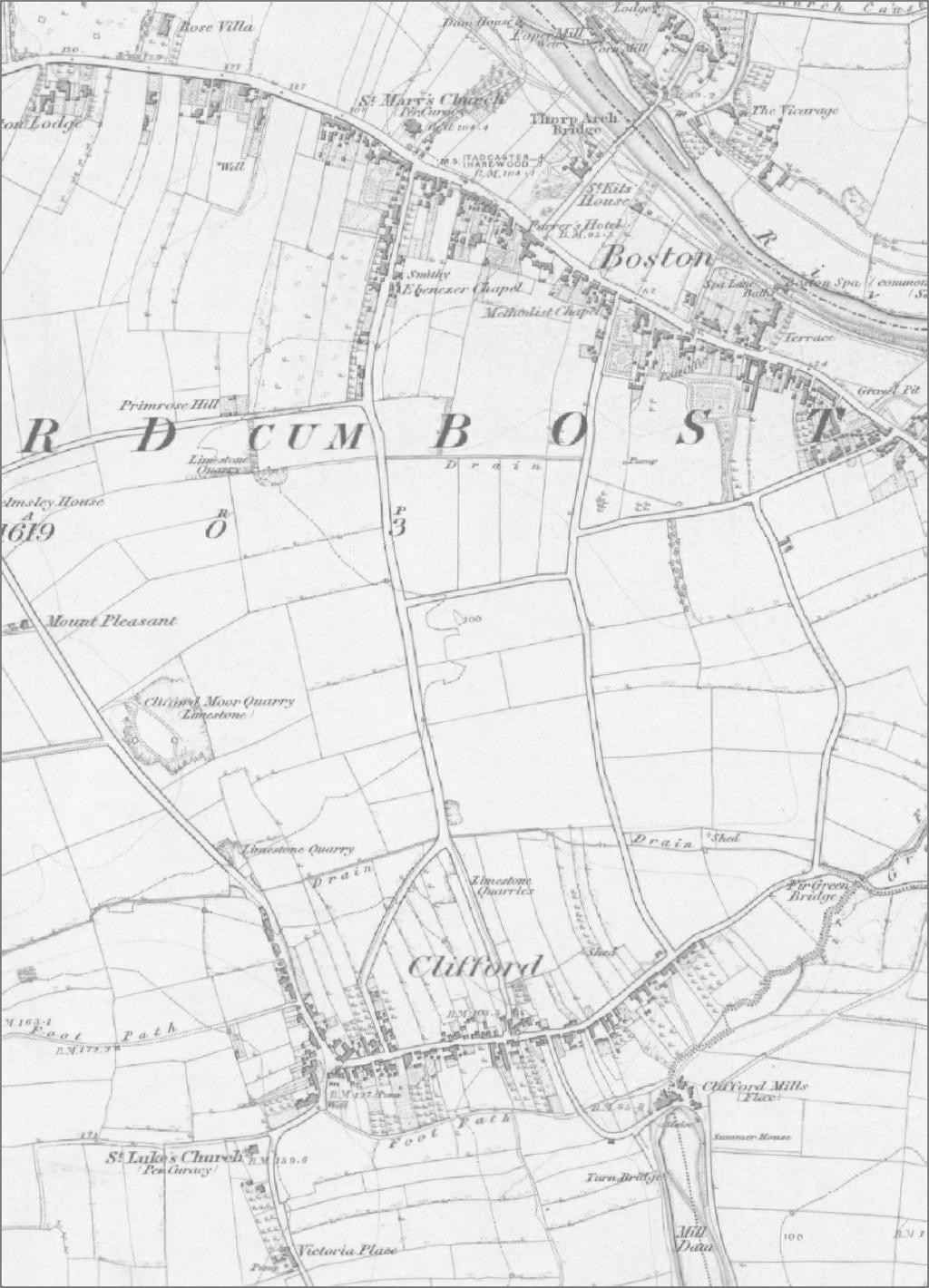
3 1.0 INTRODUCTION 1.1 This is a representation on the Leeds City Council LDF Draft Site Allocations Plan (SAP), Outer North East, Pre-Submission Changes published in February This submission relates to Pre-Submission Change No. 441, SAP site reference HG2-22, Church Street, Boston Spa and deals only with heritage representations. It has been prepared by Northern Archaeological Associates Ltd (NAA) and is being submitted, the landowners of the southern field included in this allocation and also owner of the adjacent St Mary s Children s Home (Fig. 1 Area A). Although this submission is confined to heritage considerations on behalf of Catholic Care, our client and its representatives have been liaising with Bradley Stankler Planning in respect of the representations they made which affect the former site allocations HG and HG2-23 2, and are in agreement as to the case for the two sites to be allocated separately (please refer to paragraphs 1.4 and 1.5 below). 1.3 The site lies within the southern part of the Boston Spa Conservation Area, to the south of the High Street and to the east of Church Street. It is an area of former medieval/post-medieval enclosure field system, elements of which are still legible in the landscape. The former St Mary s Children s Home is situated to the west of the site boundary, and is identified as a positive building in the conservation area 3 (Fig. 1). 1.4 Within the first SAP Publication Draft (September 2015), this land had been divided into two separate allocations HG2-23, the southern field owned by NAA s client (Fig. 1 Area A), and HG2-22, the northern field, known as Hollydene Nurseries (Fig. 1 Area B), which is in separate ownership. Both sites were identified as Phase 3 housing allocations. Following representations by Historic England about potential impact that development might have on the character and appearance of the Boston Spa Conservation Area, a heritage impact assessment was undertaken by Leeds City Council Conservation Officer 4. 1 Bradley Stankler Planning (October 2015) Written Submission in response to Leeds LDF Publication Draft Site Allocations Plan Site Ref: HG2-22 Church Street (land to the east of) Boston Spa 2 Bradley Stankler Planning (October 2016) Written Submission in response to Leeds LDF Publication Draft Site Allocations Plan Site Ref: HG2-23 Church Street (St Mary s) Boston Spa 3 Leeds City Council Boston Spa Conservation Area Appraisal and Management Plan (2009) 4 Leeds City Council LDF Site Allocations Plan Revised Publication Draft: Heritage Background Paper Outer North east (September 2016) 1
4 1.5 As a consequence of this assessment, the SAP Revised Publication Draft Section 3: Outer North East (September 2016) proposed that the two separate site allocations were conjoined and changed to a single allocation, HG2-22. The Pre-Submission Changes to the SAP has reaffirmed these proposed changes and under Pre-Submission Change No. 441 set out the details of the change. 1.6 Following representations from West Yorkshire Archaeology Advisory Service (WYAAS), the Pre-Submission Changes proposes a further amendment to the site requirements for this allocation, and states that an archaeological evaluation of the site needs to be undertaken prior to the development of the site. 1.7 Our client recognises the sensitivity of the site in terms of its heritage value and has commissioned NAA to provide heritage advice with respect to the contribution that the land specifically within their ownership makes to the significance of the conservation area, and also to advise whether the changes proposed in the Pre- Submission Changes documentation are justified. 1.8 In this submission, the south field of the current HG2-22 allocation is referred to either as Area A or as the former site allocation HG2-23On behalf of Catholic Care, this representation summarises the objections or queries to the heritage justifications which underpin the proposal to merge the sites and preserve the southern part of the south field as undeveloped open space. It also sets out the heritage reasons for why our client considers that: 1) Built development can be justified within the southern part of the former site allocation HG2-23, an area of identified higher sensitivity (Plate 2); 2) Combining the two sites is unnecessary in terms of heritage and that there are good heritage reasons why the south field (former site allocation HG2-23) can be developed independently of the north field (former site allocation HG2-22), in a manner that would preserve the character and appearance of the conservation area and be consistent with national policy; and 3) Archaeological evaluation of the site prior to development isn t justified with respect to development within the south field. 2
5 2.0 SAP CONTEXT 2.1 Figures 1 and 3 of this submission show the location of the various SAP sites referred to below in relation to - each other, the conservation area boundary, listed buildings, positive buildings in the conservation area and other heritage assets. 2.2 Within the SAP Publication Draft (September 2015) the land was divided into two separate allocations: HG2-23 (southern field) and HG2-22 (northern field and former Hollydene Nurseries) (Plate 1). Both were identified as Phase 3 housing allocations and suitable for older persons housing/independent living. The Site Capacity for HG2-22 (1.14 ha) was proposed as 19 units, HG2-23 (0.55 ha) was 17 units. Plate 1: SAP Publication Draft (September 2015) HG2-22 and HG2-23 3
6 2.3 Representations by Historic England during Public Consultationn (letters dated 21 October 2015) stated that, in order to meet the requirements of the SEA Directive, these two allocations required a more detailed heritage impact assessment due to the potential impact that development might have on the Boston Spa Conservation Area. This assessment was prepared by Leeds City Council Conservation Officers and the results presented in the SAP Heritage Background Paper (September 2016). 2.4 The outcome of this impact assessment was that both areas were considered positive spaces within the conservation area, but that the southern part of HG2-23 (as shown on Plate 2) was considered to be an area of higher sensitivity. Plate 2: Pink shaded area identified as being of higher sensitivity (Heritage Background Paper, p. 10). 2.5 In order to provide more flexibility within the allocation to respond to the heritage issues identified, it was therefore recommended that the allocations HG2-22 and HG2-23 should be combined into a single site allocation. 2.6 With respect specifically to HG2-23 (our client s landholding), the justifications for this merger were that: HG2-23 is a positive space within the conservation area which h marks the entrance or gateway into Boston Spa Conservation Area and the village of Boston Spa and 4
7 provides an important rural break and clear division between the historic village and the newer development to the south; The sensitivity of the site is increased through its location adjacent to St Mary s Children s Home, a positive building within the Conservation Area; The openness, together with the gardens of St Mary s Children s Home and the open land on the western side of Church Street, provides for a strong sense of arrival into Boston Spa. 2.7 It was concluded that the development of the majority of land at HG2-23 would therefore have a more significant impact on the conservation area, than development of the HG2-22 land, and that the loss of this site as an area of open space, would cause moderate to substantial harm. 2.8 Built development on the southern part of HG2-23 was also not considered appropriate, as it would impede the role this land has as a gateway into the historic village. However, it was considered that it could be utilised to meet the requirement for green space associated with development of HG2-22 and the less visible, less sensitive, land to the east of St Mary s Children s Home. 2.9 By combining the two allocations, and maintaining the area of higher sensitivity within the southern part of HG2-22 as open space, it was considered that this would reduce the level of harm to the conservation area, enable the net developable area of the combined area to be maximised, and so make the most efficient use of these sites overall It was further recommended that the preferred access should be through the adjacent St. Vincent s School (SAP site HG1-39 Phase 1 allocation; Fig. 1), as this would ensure that the role of the southern part of the site as a gateway into the Conservation Area is maintained (Heritage Background Paper, p. 11) The Pre-Submission Changes to the SAP has reaffirmed these proposed changes and details of the pre submission change for the amended HG2-22 site allocation (Pre- Submission Change No. 441) state that: Any development should preserve or enhance the character or appearance of the Conservation Area; 5
8 The openness of the southern part of the site has an important role in contributing to the significance of the Conservation Area, and so no built development should take place on this part of the site; Development should also seek to preserve historic field boundaries, and An archaeological evaluation of the site needs to be undertaken prior to the development of the site While our client is fully supportive of the identification of the area defined as Site HG2-22 for housing, the two former site allocations, HG2-22 and HG2-23, are in separate ownership. It is our client s view that there is no heritage reason why the two sites cannot be developed independently or why some level of development cannot be accommodated within the southern part of the site between Londsdale Meadows and St Mary s, despite its higher heritage sensitivity. 3.0 FORMER SITE REF. HG CONTRIBUTION TO SIGNIFICANCE IFICANCE OF THE BOSTON ON SPA CONSERVATION AREA Significance as gateway into Boston Spa settlement and rural divide 3.1 According to the Heritage Background Paper, the justifications for the merger of the two site allocations and for the requirement that the southern part of the former site allocation HG2-23 should remain as undeveloped open space, is that, whilst both the former sites HG2-22 and HG2-23 are both positive spaces within the conservation area, the perception of HG2-22 is very limited. HG2-23, however, lies adjacent to St Mary s Children s Home, a positive building within the conservation area, and is considered to: Mark the entrance or gateway into the Conservation Area and the village of Boston Spa. In terms of this sense of arrival, this site it particularly important as it provides a rural break between the 1980s suburban ban housing of Lonsdale Meadows and Clifton itself, and the distinctive forms that contribute to the significance of the conservation area (Leeds City Council Heritage Background Paper, 2015, p. 10) 3.2 Whilst the southern field may mark the entrance into Boston Spa Conservation Area, and Boston Spa civil parish, for reasons set out below, we would question whether its 6
9 significance as a gateway into the historic village of Boston Spa and as an area which provides a sense of arrival due to its importance as a meaningful rural break, is fully justified. 3.3 Boston Spa settlement originated in the mid-18th century and was not established as a separate civil parish until Prior to this date, from 1866 it had formed part of Clifford-cum-Boston Civil Parish, and prior to 1866, had formed part of Clifford Township, in the large ancient parish of Bramham. The 1896 civil parish boundary between Boston Spa and Clifford follows Primrose Lane, Church Street and Lonsdale Meadows, adjacent to the western and southern boundaries of the south field (Figs. 1 and 6). 3.4 Whilst the site marks the location of a relatively recent administrative gateway into Boston Spa, analysis of historic mapping indicates that it is not an historic gateway and that development had already occurred south of this area by the second half of the 19th century, prior to the establishment of the civil parish boundary. This development is first shown on the nd Edition Ordnance Survey plan and comprised St John s Institute, built prior to 1875, and three large detached family villa residences set back from the road in their own grounds Borlocco House (now St Mary s Children s Home) construction date unknown but pre-1891 and Belvedere and Claremont, which are said date from about 1864 (Figs. 2 and 5). 3.5 These buildings form a distinctive contemporary grouping on the outskirts of the village, and whilst very distinctly different in character to the earlier, smaller-scale, vernacular style buildings further to the north along Church Street, and infilling plots to the rear of High Street, they nonetheless form an integral part of Boston Spa s historic development. 3.6 We would contend that, although outside the conservation area boundary and civil parish boundary, St John s Institute, with its imposing end gables and elevations, provides a more meaningful historic gateway marking the arrival at Boston Spa, than the open space to the south of St Mary s Children s Home in the southern part of Site HG It is also clear from historic mapping that, whilst also outside the civil parish boundary, the inter-war development around the junction of Boston Road/St John s Road and along Clifford Road (Figs. 2, 3 and 7), also formed part of Boston Spa 7
10 settlement envelope in terms of its spatial relationship, rather than Clifford village. This lends further justification to querying whether too much importance is being placed on the significance of the open space as marking the entrance to the historic village. 3.8 Although St John s Institute, Claremont and Belvedere lay outside the Boston Spa Conservation Area and civil parish, they form part of the setting and historic context of the conservation area and provide a more meaningful visual and physical entrance into Boston Spa settlement. We would therefore contend that, despite technically being within Clifford parish, the gateway into Boston Spa is represented by the arrival at the junction between Boston Road and St John s Road, with St John s Institute to the west and inter-war detached houses to the east. We also consider that the open fields to the south of St John s Institute and St John s Road represent a much more meaningful historic rural divide between the Boston Spa village and Clifford village, than the open space of the southern part of SAP Site HG2-22. The significance of historic field boundaries 3.9 The area now occupied by the Boston Spa settlement historically formed part of the Clifford township field systems. As stated within the Heritage Background Paper (p.10), the site formerly identified in 2015 as HG2-22, is an area of space that respects the former medieval strip field system boundaries associated with Clifford Township, prior to the establishment of Boston Spa The significance of the division between the former allocations HG2-22 and HG2-23 is visible on the 1842 Tithe Map for the Township of Clifford-cum-Boston (Tracks in Time, The Leeds Tithe Map Project) and on the 1846 First Edition Ordnance Survey map (Fig. 4). At this date, the former HG2-22 site allocation clearly forms part of the township s former medieval strip field system, whereas the former HG2-23 site allocation, appears to form part of the larger, post-medieval enclosure field system The field boundary between the two former site allocations is therefore of some historic interest, as it appears to mark the transition between these two field systems. The hedgerow which defines this boundary, also meets the important criteria in terms of archaeology and history under Criteria 5a of the Hedgerows Regulations 1997, in that it forms an integral part of a field system recorded on a plan dated pre Similarly, the eastern hedgerow boundary of HG2-22/HG2-23 and the western hedgerow boundary of the northern field, are also important in terms of archaeology and history under the Regulations. 8
11 3.12 We would contend that the boundary that runs east from Church Street, demarcating the grounds of St Mary s Children s Home and the divide between the two former site allocations, has some significance as a historic division within the conservation area. It potentially marks the southern limit of the medieval strip field system, and also marks the change in historic building character from the small-scale vernacular style buildings alongside Church Street, and to the rear of High Street, to the group of large, detached, later-19th century buildings on the outskirts of the settlement alongside Church Street and Boston Road Both building forms contribute to the character and appearance of the conservation area and its setting and it will be important to ensure that new development respects the relevant character of the area within which it is located. Significance as an open space 3.14 Together with St Mary s Children s Home and grounds, we support the identification of the south field as a significant green open space within the conservation area The mature trees along the western boundary of both St Mary s Children s Home and the field to the south contribute significantly to the value of the streetscape and to the sense of green space within the conservation area. They are prominent in views north and south along Church Street, and continue the line of mature trees along the western side of Boston Road from St John s Institute to Belvedere villa. There is some limited visibility of the greenfield character and openness of the south field through the boundary along Church Street (Plates 3 and 4) The most open views across the former HG2-23 site allocation and into the conservation area are from Lonsdale Meadows (Plates 5 and 6). The significance of this view is that it enables an appreciation of the sense of enclosure of the grounds around the St Mary s building, but at the same time, the sense of its setting within a once rural context on the outskirts of Boston Spa. 9
12 Plate 3: View along Boston Road from near Belvedere villa, looking north towards Site HG2-22 and St Mary s Children s Home Plate 4: Site HG view of western boundary and south-west corner, from Boston Road at the junction between Church Street and Lonsdale Meadows 10
13 Plate 5: HG2-22 south boundary demonstrating minimal screening between the south field and Lonsdale Meadows Plate 6: Area B view north-west into the site from Lonsdale Meadows showing post and rail fence, open aspect and St Mary s Children s Home visible in background 3.17 We consider that one of the primary roles of the higher sensitivity area of green space is to preserve the essence of the character and setting of the suburban country villas built on the outskirts of Boston Spa and to serve as a meaningful linking space between St Mary s Children s Home (former Borlocco House) and the contemporary group of later 19 th -century buildings on the west side of Boston Road Belvedere, 11
14 Claremont and St John s Institute, which form part of the setting of the conservation area and St Mary s Children s Home Our client supports the importance of protecting the southern part the former HG2-23 site allocation from inappropriate modern development, and loss of trees. The southern field clearly has a role in maintaining the sense of a rural setting for St Mary s Children s Home, and the villas to the south, and maintaining an open aspect is important in this respect Our client, however, objects to the reasoning that development within this area would cause moderate to substantial harm to the conservation area (Historic Background Paper, p.21) Our client considers that with sensitive design and more detailed consideration of site capacity, there is potential for development within the south field which is sympathetic in character to the adjacent 19th century villas, which will retain the sense of openness and green space around these buildings and which would avoid harm to the significance of the conservation area. 4.0 WHY BUILT DEVELOPMENT CAN BE JUSTIFIED WITHIN THE SOUTHERN PART OF THE FORMER SITE ALLOCATION HG In the landowner s view, the SAP site requirements that no built development should take place within the area of higher sensitivity (Plate 2) cannot be justified on heritage grounds. 4.2 The site is green field open space within the conservation area, which makes a contribution to its character and appearance and to the setting of St Mary s Children s Home, a positive building within the conservation area. 4.3 Whilst a significant open space, the site is embedded within, and surrounded by, development of various dates, and, as discussed previously, there are good reasons to argue that the area does not represent a meaningful rural divide between the historic village and modern development, and does not represent a meaningful point of arrival into Boston Spa. 12
15 4.4 The site comprises the remains of a post-medieval enclosure field, which was subdivided in the later 19th-century so that its north-western sector could be developed as a large family villa style residence Borlocco House (now St Mary s Children s Home). Immediately outside the boundaries of the conservation area, similar subdivision of enclosure fields for development as large detached villas within areas adjacent to Boston Road, was occurring at around the same time on the west side of Boston Road and then continued during the interwar period with developments along Boston Road and St John s Road, and with further infill post-1950, between Belvedere and Claremont, and on the east side of Boston Road (Fig. 2). 4.5 Our client considers that, in addition to development within the less sensitive area to the east of St Mary s Children s Home, the site could also accommodate development within the western half of the southern area, providing it reflected the style and design of the adjacent, detached villa residence(s). Such development would need to be set back from the road within its own grounds and be on a scale and design similar to the two Victorian villas Belvedere and Claremont to the south on Boston Road. Like these villas, the building could be concealed from view by perimeter planting, which would also contribute to streetscape and preserving the sense of green space characteristic of this area. 4.6 If appropriately designed, this scale and design of development will respect the character and settlement form of this part of the conservation area, and enable open space to be maintained around the dwelling and within the south-east part of the field, thus protecting the setting of St Mary s Children s Home. 5.0 WHY THE SOUTH FIELD SHOULD BE DEVELOPED INDEPENDENTLY OF THE NORTH FIELD 5.1 The two sites are in separate ownership. Our client is the landowner of the south field and considers that there is no heritage reason why the sites should be combined and why development of the two sites should be jointly considered. 5.2 The field boundary between the north and south field potentially marks the southern limit of the medieval strip field system. It also marks the change in historic building character from the small-scale vernacular style back land and infill developments, characteristic of Church Street and the rear High Street, to the much larger, later 19th- 13
16 century detached suburban country villa-style residences set within their own grounds. 5.3 A presumption of development of the two sites as one may risk obscuring the distinction between these two distinctly different historic character areas, and may result in the loss of an important historic division within the conservation area; preserving historic field boundaries is one of the key site requirements of the Pre- Submission Changes. 5.4 The historic division between the north and south field contributes to the evidential, historic and aesthetic significance of the conservation area. The inclusion of these two fields as separate housing allocations within the SAP would help maintain this historic division and enable a positive bespoke design response to each area. 5.5 As set out above, it is considered that low density, sympathetic development, respecting the historic grain and historic character of the conservation area and its setting, is achievable within the southern part of the site. Given that development within the area to the east of St Mary s Children s Home may also need to be quite different in character to development within the field to the north, our client considers that there are very strong heritage grounds for maintaining separation between the two areas and for the SAP to revert back to including the fields as separate site allocations, but with a revised site capacity for the south field. 5.6 If this area continues to be allocated as a combined site within the SAP, then as set out in the current site requirements, the historic division between the two areas should be maintained through retention of all, or part, of the field boundary. The change in built form between the two areas should also be reflected through differences in the density and layout of new development within the two fields and also through a difference in the character and design of new build. 6.0 ARCHAEOLOGY 6.1 Pre-Submission Change No. 441 HG2-22 states that Areas of potential archaeological sensitivity are also present within the site. An archaeological evaluation of the site needs to be undertaken prior to the development of the site. 14
17 6.2 WYAAS has confirmed that the archaeological interest lies in the potential for unrecorded prehistoric or Roman remains. Aerial photographic evidence indicates that there are extensive areas of Late Iron Age-Romano-British cropmarks in the Boston Spa area (ditched enclosures, field systems, trackways, etc.). WYAAS is also concerned that unattributable linear cropmarks, identified in the field immediately to the west (Fig. 1 PRN6697), could extend into part of the application area and may be archaeologically sensitive. 6.3 It is WYAAS view that in accordance with the National Planning Policy Framework, the site would warrant pre-determination archaeological evaluation (geophysical survey and trial trenching). 6.4 In view of the small size of the south field (0.55ha), it may be difficult to obtain meaningful geophysical survey results, or a meaningful trial trenching strategy. Given these issues, and the limited archaeological potential of the site, our client considers that the requirement for pre-determination evaluation of this area is unreasonable and requests that this site requirement be amended to provide for the protection of archaeological interests through planning conditions. 15
18
19
20
21
22
23
Settlement Boundaries Methodology North Northumberland Coast Neighbourhood Plan (August 2016)
") Introduction This background paper sets out a methodology for the definition of settlement boundaries in the North Northumberland Coast Neighbourhood Plan. The neighbourhood plan is planning positively
Introduction This background paper sets out a methodology for the definition of settlement boundaries in the North Northumberland Coast Neighbourhood Plan. The neighbourhood plan is planning positively
Draft Hailey Neighbourhood Plan
 Persimmon Homes (Wessex) Draft Hailey Neighbourhood Plan Representations to West Oxfordshire District Council s Regulation 16 Consultation December 2018 2 Copyright 2018 Persimmon Homes Ltd. All rights
Examination of South Cambridgeshire Local Plan
 Matter SC6A - Policy SS/5 Waterbeach New Town Historic England( formerly English Heritage) 874 Rep Nos 59748, 60250, 60253 Examination of South Cambridgeshire Local Plan Historic England, Hearing Statement
LEEDS SITE ALLOCATIONS PLAN MATTER 3 GREEN BELT KCS DEVELOPMENT AUGUST 2017
 LEEDS SITE ALLOCATIONS PLAN MATTER 3 GREEN BELT KCS DEVELOPMENT AUGUST 2017 Smith Limited Suite 9C Joseph s Well Hanover Walk Leeds LS3 1AB T: 0113 2431919 F: 0113 2422198 E: planning@peacockandsmith.co.uk
Plaistow and Ifold Neighbourhood Plan Pre-Submission Consultation Draft
 Mrs Beverley Weddell Clerk to Plaistow And Ifold Parish Council Lock House Lodge Knightons Lane Dunsfold, GU8 4NU. Dear Mrs Weddell, Our ref: Your ref: Telephone Fax HD/P5402/ 01483 252040 18 th October
Historic England Advice Report 26 August 2016
 Case Name: Kingsland Castle Case Number: 1435892 Background Historic England has been asked to review the scheduling for Kingsland Castle. The land on which the monument lies is understood to be for sale.
MATURE SUBURBS RESIDENTIAL DEVELOPMENT GUIDELINES
 MATURE SUBURBS RESIDENTIAL DEVELOPMENT GUIDELINES DRAFT FEBRUARY 2005 BIRMINGHAM CITY COUNCIL 1 Introduction Mature Suburbs Residential Development Guidelines - Interim Supplementary Planning Advice -
DEVELOPMENT MANAGEMENT REPORT
 ITEM A08-1 DEVELOPMENT MANAGEMENT REPORT TO: BY: DATE: DEVELOPMENT: SITE: WARD: APPLICATION: APPLICANT: Development Management Committee Development Manager Proposed live/work unit in connection with existing
CAIRNGORMS NATIONAL PARK AUTHORITY
 Title: Prepared by: REPORT ON CALLED-IN PLANNING APPLICATION MARY GRIER, PLANNING OFFICER (DEVELOPMENT MANAGEMENT) DEVELOPMENT PROPOSED: REFERENCE: APPLICANT: FULL PERMISSION FOR ALTERATIONS, EXTENSIONS
Plumpton Neighbourhood Development Plan Revised Pre Submission Document - Regulation 14 Consultation
 REPRESENTATIONS... Plumpton Parish Council Plumpton Neighbourhood Development Plan Revised Pre Submission Document - Regulation 14 Consultation Representations submitted on behalf of: Cala Homes (South
Neighbourhood Plan Representation
 Date: 10 th November 2017 Neighbourhood Plan Representation Land to the east of Callow Hill Road, Alvechurch Introduction This representation has been prepared by RPS Planning and Development on behalf
Oxford Green Belt Study. Summary of Final Report Prepared by LUC October 2015
 Oxford Green Belt Study Summary of Final Report Prepared by LUC October 2015 Project Title: Oxford Green Belt Study Client: Oxfordshire County Council Version Date Version Details Prepared by Checked by
INCREMENTAL CHANGE AREA REVIEW March 2015 Page 1
 INCREMENTAL CHANGE AREA REVIEW March 2015 Page 1 Table of Contents Introduction... 3 Background to Review... 3 Comparison of the Schedules to the General Residential Zone... 7 Methodology... 7 Policy Context...
CA//17/02777/FUL. Scale 1:1,250. Planning Services Canterbury City Council Military Road Canterbury Kent CT1 1YW
 O CA//17/02777/FUL Scale 1:1,250 Map Dated: 15/03/2018 Planning Services Canterbury City Council Military Road Canterbury Kent CT1 1YW AGENDA ITEM NO 16 PLANNING COMMITTEE APPLICATION NUMBER: SITE LOCATION:
STATEMENT OF OBJECTION TO THE PROPOSED DEVELOPMENT OF LAND AT CHURCH CLIFF DRIVE FILEY
 STATEMENT OF OBJECTION TO THE PROPOSED DEVELOPMENT OF LAND AT CHURCH CLIFF DRIVE FILEY You will be aware that Scarborough borough council have adopted a new local plan that includes land at Church Cliff
Case Officer: Sarah Kay File No: CHE/14/00515/REM Tel. No: (01246) Plot No: 2/6132 Ctte Date: 15 th September 2014 ITEM 1
 Plot No: 2/6132 Ctte Date: 15 th September 2014 ITEM 1") Case Officer: Sarah Kay File No: CHE/14/00515/REM Tel. No: (01246) 345786 Plot No: 2/6132 Ctte Date: 15 th September 2014 ITEM 1 APPROVAL OF RESERVED MATTERS FROM APPLICATION CHE/12/00234/OUT (1) LAYOUT,
Case Officer: Sarah Kay File No: CHE/14/00515/REM Tel. No: (01246) 345786 Plot No: 2/6132 Ctte Date: 15 th September 2014 ITEM 1 APPROVAL OF RESERVED MATTERS FROM APPLICATION CHE/12/00234/OUT (1) LAYOUT,
SOUTH CAMBRIDGESHIRE DISTRICT COUNCIL. Executive Director (Operational Services) Corporate Manager (Planning and New Communities)
 Corporate Manager (Planning and New Communities)") SOUTH CAMBRIDGESHIRE DISTRICT COUNCIL REPORT TO: Planning Committee 12 January 2011 AUTHOR/S: Executive Director (Operational Services) Corporate Manager (Planning and New Communities) Notes: S/1848/10
SOUTH CAMBRIDGESHIRE DISTRICT COUNCIL REPORT TO: Planning Committee 12 January 2011 AUTHOR/S: Executive Director (Operational Services) Corporate Manager (Planning and New Communities) Notes: S/1848/10
Parish of Repton NEIGHBOURHOOD DEVELOPMENT PLAN
 Parish of Repton NEIGHBOURHOOD DEVELOPMENT PLAN BASIC CONDITIONS STATEMENT December 2018 CEF 4 Legal Requirements This statement has been produced by the NDP Working Group on behalf of Repton Parish Council
LONGDEN VILLAGE DEVELOPMENT STATEMENT
 LONGDEN VILLAGE DEVELOPMENT STATEMENT 2017-2027 1 Longden Development Statement 2017-2027 15/01/18 1. Background 1.1 Longden Village Longden village is a very rural and traditional community first mentioned
APP/G1630/W/15/
 Appeal Decision Site visit made on 20 October 2015 by William Fieldhouse BA (Hons) MA MRTPI an Inspector appointed by the Secretary of State for Communities and Local Government Decision date: 20 November
Archaeological evaluation at Willowdene, Chelmsford Road, Felsted, Essex
 Archaeological evaluation at Willowdene, Chelmsford Road, Felsted, Essex August 2013 report prepared by Ben Holloway on behalf of Mr Anthony McGurren Planning reference: UTT/13/0235 CAT project ref.: 13/07g
an Inspector appointed by the Secretary of State for Communities and Local Government
 Appeal Decision Site visit made on 14 July 2015 by I Radcliffe BSc(Hons) MCIEH DMS an Inspector appointed by the Secretary of State for Communities and Local Government Decision date: 18 August 2015 Appeal
GUILDFORD BOROUGH GREEN BELT AND COUNTRYSIDE STUDY
 GUILDFORD BOROUGH GREEN BELT AND COUNTRYSIDE STUDY Volume II - Addendum On behalf of Guildford Borough Council PPG Ref : BNL.0287 April 2014 COPYRIGHT The conents of this document must not be copied or
Perth and Kinross Council Development Management Committee 20 February 2013 Report of Handling by Development Quality Manager
 Perth and Kinross Council Development Management Committee 20 February 2013 Report of Handling by Development Quality Manager 4(4)(iii) 13/81 Erection of sports hall, associated changing facilities, offices
DESIGN & ACCESS STATEMENT
 DESIGN & ACCESS STATEMENT January 2016 Contents Introduction section 1 Section 1 - Introduction Section 2 - Assessment Section 3 - Involvement Section 4 - Evaluation Section 5 - Design Section 6 - Layout
EAST OF ENGLAND OFFICE
 Mr Philip Isbell Direct Dial: 01223 582751 Mid Suffolk District Council 131 high Street Our ref: P00524468 Needham Market Ipswich Suffolk IP6 8DL 18 January 2017 Dear Mr Isbell T&CP (Development Management
Harrow Lane, St Leonards-on-Sea, East Sussex, TN37 7JZ ERECTION OF 113 DWELLINGS TOGETHER WITH ESTATE ROADS (DETAILED SUBMISSION)
") AGENDA ITEM NO: Report to: PLANNING BOARD Date: 10 September, 2003 Report from: Borough Planning Officer Application Address: Proposal: Application No: Recommendation: Ward: File No: Applicant: Interest:
AGENDA ITEM NO: Report to: PLANNING BOARD Date: 10 September, 2003 Report from: Borough Planning Officer Application Address: Proposal: Application No: Recommendation: Ward: File No: Applicant: Interest:
DESIGN & ACCESS STATEMENT
 . DESIGN & ACCESS STATEMENT Site Adjacent to The Manor House, Upper Street,, Kingsdown, Deal, Kent. DESIGNS ARCHITECTURE + PLANNING CONTENTS Design and Access Statement Introduction Site and Location Planning
9 Archaeology & Cultural Heritage
 High Clachaig Wind Farm Scoping Report Page 56 9 Archaeology & Cultural Heritage 9.1 Introduction Cultural heritage in this context means the above- and below-ground archaeological resources, built heritage,
4 RESIDENTIAL ZONE. 4.1 Background
 4 RESIDENTIAL ZONE 4.1 Background The residential areas within the City are characterised by mainly lowrise dwellings sited on individual allotments. Past architectural styles, settlement patterns and
LETTER OF OBJECTION LAND TO THE SOUTH WEST OF FORGE GARAGE, HIGH STREET, PENSHURST, KENT, TN11 8BU
 Senior Planning Officer Andrew Byrne Sevenoaks District Council Community & Planning Services PO Box 183 Argyle Road Sevenoaks Kent TN13 1GN 04 November 2011 Your Ref: 11/02258/FUL For the attention of
A payment of 1080 is due in this instance, for a meeting and follow up written response, and will be made by card over the phone.
 JPPC ref: AG/6002 18 th September 2014 Planning Services Vale of White Horse District Council Benson Lane Crowmarsh Gifford Wallingford OX10 8ED Dear Sir/Madam REQUEST FOR PRE-APPLICATION ADVICE RE: RESIDENTIAL
Agenda Update Sheet. Planning Committee A
 Agenda Update Sheet Planning Committee A Date: 22 nd June 2017 Agenda Section 5: Applications Part I Recommended for Approval ITEM: 1 DM/16/5502 Summary of Consultees Surrey County Council No objection
INTRODUCTION. Land West of Main Road, Stanton Harcourt THE SITE. Why is the Site Suitable for Development?
 0 INTRODUCTION THE SITE Application Boundary Gladman Developments Ltd has successfully invested in communities throughout the UK over the past 0 years, developing high quality and sustainable residential,
Conservation Area Designation, amendments and Review
 Conservation Area Designation, amendments and Review Location: Any area largely confined to Park Road and St. James Avenue which includes the following properties: St. James Church, St. James Road; No.
Purpose of the Variation: The purpose of an ACA is to protect and enhance the special character of the ACA by:
 To the Lord Mayor and Report No. 202/2017 Members of Dublin City Council Report of the Assistant Chief Executive Proposed Draft Variation (No. 2) of Dublin City Development Plan 2016 2022 Designating Hollybrook
Salhouse Parish Council, 11 th November Response to Planning Application
 Salhouse Parish Council, 11 th November 2013 Response to Planning Application 20131408 Summary Salhouse Parish Council (SPC) has received via Broadland District Council a Planning Application for a 5MWp
Effingham Neighbourhood Plan 1. Basic Conditions Statement
 Effingham Neighbourhood Plan 1 Basic Conditions Statement Effingham Neighbourhood Plan 2016: Basic Conditions Statement 2 Contents This statement has been prepared by Effingham Parish Council to accompany
INTRODUCTION CURRENT APPLICATION
 05/01805/FUL & 05/01807/LBC ERECTION OF A SINGLE DWELLING HOUSE WITH ANCILLARY ACCOMMODATION AT Flamingo Zoological Gardens, Olney Road, Weston Underwood FOR Mr A J Crowther (as amended by letter dated
ROCHFORD LOCAL DEVELOPMENT FRAMEWORK: Sustainability Appraisal/ Strategic Environmental Assessment. Rochford Core Strategy Preferred Options Document
 ROCHFORD LOCAL DEVELOPMENT FRAMEWORK: Sustainability Appraisal/ Strategic Environmental Assessment Non Technical Summary Rochford Core Strategy Preferred Options Document October 2008 SUSTAINABILITY APPRAISAL
Joint Core Strategy Rushden Sustainable Urban Extension
 Date Page 1 of 18 Report Originator Title Planning Manager Joint Core Strategy Rushden Sustainable Urban Extension 1. PURPOSE OF REPORT 1.1 To consider representations received on the emerging Joint Core
BORRISOKANE SETTLEMENT PLAN
 BORRISOKANE SETTLEMENT PLAN 1.0 General Introduction and Development Context Location Borrisokane is located 15km north of Nenagh on the N52. While the town is primarily residential, it acts as a market
Open Report on behalf of Richard Wills Executive Director for Communities. Planning and Regulation Committee. County Council Application L/0736/13
 Agenda Item 7.3 Regulatory and Other Committee Open Report on behalf of Richard Wills Executive Director for Communities Report to: Planning and Regulation Committee Date: 15 July 2013 Subject: County
SOUTH EAST LINCOLNSHIRE LOCAL PLAN: HOUSING PAPER DONINGTON (JUNE 2016)
") SOUTH EAST LINCOLNSHIRE LOCAL PLAN: HOUSING PAPER DONINGTON (JUNE 2016) 1 DONINGTON S PLACE IN THE SPATIAL STRATEGY 1.1 Policy 2 of the South East Lincolnshire Local Plan 2011-2036 Draft for Public Consultation
SOUTH EAST LINCOLNSHIRE LOCAL PLAN: HOUSING PAPER DONINGTON (JUNE 2016) 1 DONINGTON S PLACE IN THE SPATIAL STRATEGY 1.1 Policy 2 of the South East Lincolnshire Local Plan 2011-2036 Draft for Public Consultation
Welcome to our exhibition
 Welcome to our exhibition The Homes & Communities Agency (HCA) welcomes you to this public exhibition explaining our proposals for the redevelopment of the former Lea Castle Hospital site. About the Homes
SOUTH CAMBRIDGESHIRE DISTRICT COUNCIL. Director of Development Services
 SOUTH CAMBRIDGESHIRE DISTRICT COUNCIL REPORT TO: Development and Conservation Control Committee 5 th April 2006 AUTHOR/S: Director of Development Services S/2290/05/F Haslingfield House (Revised Design)
Neighbourhood Planning Guidance Local Green Spaces
 Neighbourhood Planning Guidance Local Green Spaces Introduction This guidance note has been produced for communities preparing neighbourhood plans in North Dorset to help them to identify, assess and designate
Welcome. Land adjacent Sandy Lane WALTHAM CHASE THE PROPOSED SITE
 Land adjacent Sandy Lane WALTHAM CHASE Existing Linden Homes developments Welcome Welcome to Linden Homes Southern s ( Linden ) public exhibition about its proposals for a range of high-quality homes for
Newcourt Masterplan. November Exeter Local Development Framework
 Newcourt Masterplan November 2010 Exeter Local Development Framework Background The Exeter Core Strategy Proposed Submission sets out the vision, objectives and strategy for the development of Exeter up
PUBLIC REALM STRATEGY
 CONSULTATION DRAFT PUBLIC REALM STRATEGY Trenchard Street & Frogmore Street City Design Group Place Directorate Public Realm Strategy Trenchard Street & Frogmore Street Contents 1. Introduction 2. Understanding
Perth and Kinross Council Development Management Committee 24 April 2013 Report of Handling by Development Quality Manager
 Perth and Kinross Council Development Management Committee 24 April 2013 Report of Handling by Development Quality Manager Alterations,Carpenter House, Carpenter Street, Perth, PH1 5GB Ref. No: 13/00303/FLL
Toddington Central Bedfordshire Stage 3 Green Belt Study December 2017
 Toddington Central Bedfordshire Stage 3 Green Belt Study December 2017 Site: ALP086 - Middle Lakes, Toddington Site size (ha): 2.83 Site: ALP086 - Middle Lakes, Toddington Site size (ha): 2.83 Site description
SOUTH CAMBRIDGESHIRE DISTRICT COUNCIL. Planning and New Communities Director
 SOUTH CAMBRIDGESHIRE DISTRICT COUNCIL REPORT TO: Planning Committee 3 October 2012 AUTHOR/S: Planning and New Communities Director S/1723/12/OL CAXTON AND ELSWORTH OUTLINE APPLICATION FOR ERECTION OF RESTAURANT/TAKEAWAY
BEDFORD BOROUGH COUNCIL PLAN IMPLEMENTATION MONITORING REPORT
 BEDFORD BOROUGH COUNCIL PLAN IMPLEMENTATION MONITORING REPORT 2017-18 Summary 1 Progress on local development documents 1 Local development documents adopted in the monitoring period 1st April 2017 31st
Variation No 1: Dundalk & Environs Development Plan Core Strategy
 Variation No 1: Dundalk & Environs Development Plan 2009-2015 Core Strategy Adopted on 29 th August 2011 CONTENTS Page Section 1 1.0 Synopsis 1 1.1 Background Document 1 1.2 Variation of Dundalk and Environs
Ref: A073350/SM/sm Date: 13 September 2013
 Ref: A073350/SM/sm Date: 13 September 2013 Ian Parkinson Development Control Team Leader Planning Portsmouth City Council Civic Offices Guildhall Square Portsmouth PO1 2AY Dear Ian LIGHT & GLEAVE VILLA
Lancaster Conservation Area Appraisal. Character Area 8. Cathedral
 Lancaster Conservation Area Appraisal Character Area 8. Cathedral March 2013 118 3.8 Character Area 8. Cathedral 3.8.1. Definition of Special Interest "This character area is distinctive for the fine group
Blandford Forum Town Council, Blandford St Mary Parish Council and Bryanston Parish Council
 Blandford Forum Town Council, Blandford St Mary Parish Council and Bryanston Parish Council Blandford + Neighbourhood Plan 2 Pre-Submission Plan Consultation (November 2018) Representations submitted on
Persimmon Homes Thames Valley Date received: 2 nd April week date(major): 2 nd July 2014 Ward: Nascot
: 2 nd July 2014 Ward: Nascot") PART A Report of: DEVELOPMENT MANAGEMENT SECTION HEAD Date of Committee: 26 th June 2014 Site address: Rounton, 28, Nascot Wood Road Reference Number: 14/00497/REM Description of Development: Reserved
PART A Report of: DEVELOPMENT MANAGEMENT SECTION HEAD Date of Committee: 26 th June 2014 Site address: Rounton, 28, Nascot Wood Road Reference Number: 14/00497/REM Description of Development: Reserved
PHASE III: Reserved Matters Submission
 Statement of Compliance with the outline approval for the proposed residential development of land at: BURGES LANE, WIVELISCOMBE PHASE III: Reserved Matters Submission Foreword Contents: This Statement
About 10% of the Borough's population lives in the seven rural parishes. Population figures from the 1991 census are given below:-
 8. THE DISTRICT VILLAGES 8.1 Population About 10% of the Borough's population lives in the seven rural parishes. Population figures from the 1991 census are given below:- Village No. of Persons Cottingham
Oaksey Neighbourhood Plan
 Oaksey Neighbourhood Plan Oaksey Parish Council Housing Site Selection Methodology March 2018 Oaksey Neighbourhood Plan 2018-2026 Housing Site Selection Methodology March 2018 Pre-Submission draft of the
Alder View. Introduction. Alder View. Harwell. The Vision. The Team. Taylor Wimpey
 Introduction Welcome to the public exhibition for, a development by Taylor Wimpey on the land south of Grove Road,. This exhibition will provide an overview of the development proposals for the site and
an Inspector appointed by the Secretary of State for Communities and Local Government
 Appeal Decision Site visit made on 12 November 2015 by Helen Heward BSc Hons MRTPI an Inspector appointed by the Secretary of State for Communities and Local Government Decision date: 27 July 2016 Appeal
1. Local Plan Context
 1. Local Plan Context WHY ARE YOU HERE? ABOUT US PLANNING APPLICATION CONSULTATION Stewart Milne Homes are in the process of preparing a detailed planning application for a development of approximately
Designations protecting the historic designed landscape
 Historic Landscape Project Designations protecting the historic designed landscape A. Key national designations affecting the historic environment: 1. Listed buildings 2. Scheduled Monuments (generally
Archaeological Evaluation and Assessment of Land at Kent Cottage, 19 Chapel Street, Hythe, Kent
 Archaeological Evaluation and Assessment of Land at Kent Cottage, 19 Chapel Street, Hythe, Kent Planning Application Y13/0463/SH Date of Report: 29/04/2015 Report for Marc Carney SWAT. ARCHAEOLOGY Swale
OKEFORD FITZPAINE NEIGHBOURHOOD PLAN
 OKEFORD FITZPAINE NEIGHBOURHOOD PLAN Dear Parishioner, The Neighbourhood Plan Project Team have prepared this leaflet to summarise the full Neighbourhood Plan document. It provides a summary of the Vision,
Neighbourhood Planning Local Green Spaces
 Neighbourhood Planning Local Green Spaces Introduction... 2 1. Why green space is important... 4 2. Neighbourhood plans and green space... 6 3. Evidence... 8 Statutory designations... 9 Green space audit...
HERITAGE COUNTS 2017 East of England
 HERITAGE COUNTS 2017 East of England Introduction Heritage Counts 2017 is the sixteenth annual survey of the state of England s historic environment. This Regional Report is prepared by Historic England
There are two assessment methods used. The first is according to the criteria set out in the Neighbourhood Plan which are set out below.
 Background Paper 4 Site Assessments Context This background paper has been compiled to support the Gotham Neighbourhood Plan and is intended to document the viability of sites around Gotham with respect
3. Neighbourhood Plans and Strategic Environmental Assessment
 1. Introduction This report sets out a draft Screening Determination for the Preston Parish Council s Neighbourhood Plan and has been prepared by rth Hertfordshire District Council. The purpose of the
12 TH ANNUAL CHILTERNS AONB PLANNING CONFERENCE ENGLISH HERITAGE: HISTORIC ENVIRONMENT GOOD PRACTICE ADVICE
 12 TH ANNUAL CHILTERNS AONB PLANNING CONFERENCE ENGLISH HERITAGE: HISTORIC ENVIRONMENT GOOD PRACTICE ADVICE MARTIN SMALL HISTORIC ENVIRONMENT PLANNING ADVISER ENGLISH HERITAGE Policy ENGLISH HERITAGE GOOD
Useful Studio 1st Floor, The Clove Building 4 Maguire Street, Butler s Wharf London SE1 2NQ
 Ms M Barlow Useful Studio 1st Floor, The Clove Building 4 Maguire Street, Butler s Wharf London SE1 2NQ Our ref: PL00049085 By email: michelle.b@usefulstudio.co.uk 12 th December 2016 Dear Ms Barlow, Re:
An Archaeological Evaluation at Granta Cottages, Newmarket Road, Great Chesterford, Essex. August 2015
 An Archaeological Evaluation at Granta Cottages, Newmarket Road, Great Chesterford, Essex August 2015 by Pip Parmenter and Ben Holloway on behalf of Mr G Elmer and Mrs L King CAT project ref.: 15/06a NGR:
DONCASTER METROPOLITAN BOROUGH COUNCIL. PLANNING COMMITTEE - 15th October Expiry Date:
 DONCASTER METROPOLITAN BOROUGH COUNCIL PLANNING COMMITTEE - 15th October 2013 Application 3 Application Number: 13/01158/FUL Application Expiry Date: 31st July 2013 Application Type: Full Application Proposal
Eastern Golf Course, Doncaster Road, Doncaster
 , 463-535 Road, Heritage Assessment in accordance with Schedule to the Development Plan Overlay July 2013 bryce raworth conservation urban design 19 Victoria Street St Kilda Vic 3182 , 463-535 Road, Heritage
an Inspector appointed by the Secretary of State for Communities and Local Government
 Appeal Decision Site visit made on 6 November 2017 by Rachel Walmsley BSc MSc MA MRTPI an Inspector appointed by the Secretary of State for Communities and Local Government Decision date: 19 th January
SOUTH CAMBRIDGESHIRE DISTRICT COUNCIL. Planning and New Communities Director
 SOUTH CAMBRIDGESHIRE DISTRICT COUNCIL REPORT TO: Planning Committee 5 June 2013 AUTHOR/S: Planning and New Communities Director S/0747/13/FL HISTON Construction of Car Park at Histon Baptist Church, Station
Derry City and Strabane District Council Planning Committee Report. Amended layout from approval A/2004/0462/F with reduction from 166 units
 Derry City and Strabane District Council Planning Committee Report COMMITTEE DATE: 1 st February 2017 APPLICATION No: APPLICATION TYPE: PROPOSAL: LOCATION: APPLICANT: AGENT: Full Planning application Amended
Reserved Matters application for a site that straddles the boundary between CBC and BBC
 BBC APPLICATION 15/02682/MAR NUMBER CBC APPLICATION CB/15/04294/RM NUMBER LOCATION Wixams Land at former storage depot, Bedford Road, Wilstead Bedfordshire PROPOSAL Reserved Matters Application for Strategic
Mendip Local Plan Part II: Sites and Policies - Issues and Options Consultation MDC LPP2 consultation response.pdf
 From: Nicola Duke Sent: 15 February 2018 11:17 To: PlanningPolicy Subject: Mendip Local Plan Part II: Sites and Policies - Issues and Options Consultation Attachments: 180215
Site Assessment Technical Document Appendix A: Glossary
 Central Bedfordshire Council www.centralbedfordshire.gov.uk Site Assessment Technical Document Appendix A: Glossary July 2017 1.1.11-1 - ii Appendix A: Glossary Term Agricultural Land Classification AONB
Babergh and Mid Suffolk Joint Draft Local Plan Consultation, August 2017, Public Consultation
 Babergh and Mid Suffolk Joint Draft Local Plan Consultation, August 2017, Public Consultation Having reviewed the documents, the Society has made the following response: Housing Delivery Q 7. Do you agree
Local Development Scheme
 Local Development Scheme 2012 2016 The Local Development Scheme (LDS) is a project plan that outlines how and when the Authority will update its planning policies and other associated documents. It ensures
SOUTH CAMBRIDGESHIRE DISTRICT COUNCIL. Planning and New Communities Director
 SOUTH CAMBRIDGESHIRE DISTRICT COUNCIL REPORT TO: Planning Committee 9 January 2013 AUTHOR/S: Planning and New Communities Director S/2270/12/FL FEN DRAYTON 850m long flood defence embankment ranging in
Mid Coquetdale Neighbourhood Plan - Vision and Objectives Consultation
 Neighbourhood Planning came into force in 2011, through the Localism Bill. It gives us a unique opportunity to produce our own Neighbourhood Development Plan for our own area. Rothbury Parish Council,
WELCOME GYPSY LANE. Wider Site Location plan. Proposals for the development of LAND OFF FOXLYDIATE LANE WEBHEATH. Proposals for the development of
 WELCOME The developers are preparing an outline planning application for a residential led development and need the community s views in order to develop the proposals further WHAT IS PROPOSED? A high
Site north of Hattersley Road West (east of Fields Farm Road), Hattersley
, Hattersley") Application Number 17/00982/REM Proposal Site Applicant Recommendation Reason for report Application for the approval of reserved matters (means of access, landscaping, layout, scale and appearance) relating
Application Number 17/00982/REM Proposal Site Applicant Recommendation Reason for report Application for the approval of reserved matters (means of access, landscaping, layout, scale and appearance) relating
WOKING DESIGN SUPPLEMENTARY PLANNING DOCUMENT (SPD)
") Agenda Item No. 5 EECUTIVE - 15 JANUARY 2015 Executive Summary WOKING DESIGN SUPPLEMENTARY PLANNING DOCUMENT (SPD) The report outlines the various responses to the consultation on the Design Supplementary
Agenda Item No. 5 EECUTIVE - 15 JANUARY 2015 Executive Summary WOKING DESIGN SUPPLEMENTARY PLANNING DOCUMENT (SPD) The report outlines the various responses to the consultation on the Design Supplementary
PLANNING COMMITTEE. 14 October 2014
 AGENDA ITEM NO 8 PLANNING COMMITTEE 14 October 2014 APPLICATION NUMBER : CA//14/01744/FUL PROPOSAL : Extension and conversion of roof space of an existing detached bungalow together with enhanced parking
PLANNING COMMITTEE REPORT
 PLANNING COMMITTEE REPORT TO: BY: Planning Committee South Head of Development DATE: 19 December 2017 DEVELOPMENT: SITE: WARD: APPLICATION: APPLICANT: Conversion of existing water storage reservoir to
Great Easton Neighbourhood Plan Statement of Basic Conditions
 Great Easton Neighbourhood Plan 2017-2031 Statement of Basic Conditions OCTOBER 2016 GREAT EASTON PARISH COUNCIL Contents 1.0 Introduction....Page 2 2.0 Summary of Submission Documents and Supporting Evidence..
Derry City and Strabane District Council Planning Committee Report
 Derry City and Strabane District Council Planning Committee Report COMMITTEE DATE: 23 rd March 2016 APPLICATION No: APPLICATION TYPE: PROPOSAL: LOCATION: APPLICANT: LA11/2015/0395/F Residential Development
Environmental and Landscape Mapping
 Environmental and Landscape Mapping In support of the Calveley Neighbourhood Plan November 2016 Project Name and Number: Calveley Neighbourhood Plan 16-025 Document Name and Revision: Environmental and
Ebbsfleet Development Corporation
 Title of Paper Planning and Housing Delivery Report September 2018 Presented by Sub-Committee Mark Pullin, Chief Planning Officer Planning Committee Purpose of Paper and Executive Summary This paper provides
Replacement Golf Course Facilities and Residential Development, Churston. Environmental Statement Non-Technical Summary
 Replacement Golf Course Facilities and Residential Development, Churston Environmental Statement Non-Technical Summary July 2011 Reproduced from the Ordnance Survey s map with the permission of the Controller
ENVIRONMENTAL AND LANDSCAPE MAPPING
 APPENDIX IV : Environmental and Landscape Mapping ENVIRONMENTAL AND LANDSCAPE MAPPING Calveley Neighbourhood Plan November 2016 ENVIRONMENTAL AND LANDSCAPE MAPPING Calveley Neighbourhood Plan Calveley
STRENSALL RAILWAY BUILDINGS CONSERVATION AREA APPRAISAL. In association with Strensall with Towthorpe Parish Council
 STRENSALL RAILWAY BUILDINGS CONSERVATION AREA APPRAISAL In association with Strensall with Towthorpe Parish Council CONTENTS Page 1 Introduction 2 2 Location and Context 3 3 Topography and Setting 4 4
Welcome to our public exhibition
 About our development Welcome to our public exhibition This exhibition gives you the chance to view and comment on our proposals for a new residential development of 165 high-quality homes, along with